Fairfield, Wisconsin
Submit your own pictures of this town and show them to the world
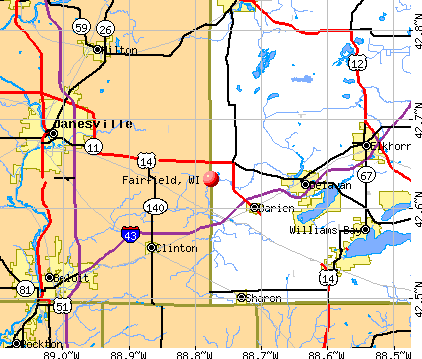
- OSM Map
- General Map
- Google Map
- MSN Map
Population change since 2000: +5.3%
 |
| Males: 548 | |
| Females: 529 |
| Median resident age: | 45.2 years |
| Wisconsin median age: | 42.6 years |
Zip codes: 53913.
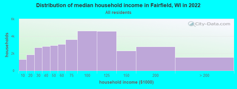
| Fairfield: | $83,860 |
| WI: | $70,996 |
Estimated per capita income in 2022: $41,310 (it was $22,155 in 2000)
Fairfield town income, earnings, and wages data
Estimated median house or condo value in 2022: $326,733 (it was $134,500 in 2000)
| Fairfield: | $326,733 |
| WI: | $252,800 |
Mean prices in 2022: all housing units: $289,289; detached houses: $310,852; townhouses or other attached units: $241,946; in 2-unit structures: $244,471; in 3-to-4-unit structures: $144,121; in 5-or-more-unit structures: $260,772; mobile homes: $71,017
Detailed information about poverty and poor residents in Fairfield, WI


- 1,05397.8%White alone
- 131.2%Hispanic
- 70.6%Asian alone
- 30.3%American Indian alone
- 10.09%Two or more races
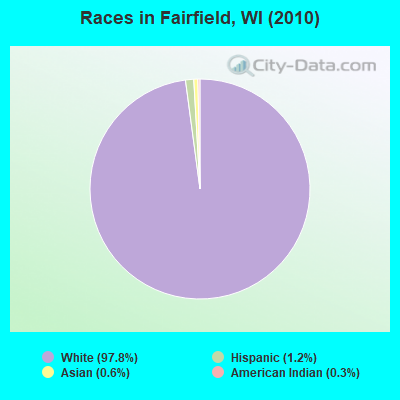
Races in Fairfield detailed stats: ancestries, foreign born residents, place of birth
 Recent articles from our blog. Our writers, many of them Ph.D. graduates or candidates, create easy-to-read articles on a wide variety of topics.

 | Does anyone know what will replace Sears at Bay shore? (40 replies) |
| Is the north side of Milwaukee THAT bad? (71 replies) |
| Green Bay Lacks Vision, Zoning and Leadership (83 replies) |
| Would I like the Milwaukee area? (17 replies) |
| Anyone sick of winter yet? (68 replies) |
Latest news from Fairfield, WI collected exclusively by city-data.com from local newspapers, TV, and radio stations
Ancestries: German (55.1%), Irish (17.8%), English (14.0%), Norwegian (12.5%), United States (5.7%), Polish (4.0%).
Current Local Time: CST time zone
Elevation: 920 feet
Land area: 35.0 square miles.
Population density: 31 people per square mile (very low).
15 residents are foreign born
| This town: | 1.5% |
| Wisconsin: | 3.6% |
| Fairfield town: | 1.4% ($1,935) |
| Wisconsin: | 2.0% ($2,245) |
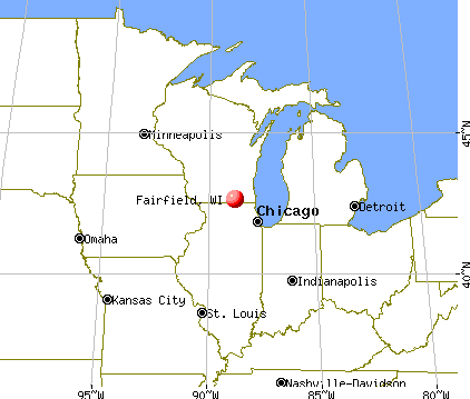
Nearest city with pop. 50,000+: Madison, WI  (35.3 miles , pop. 208,054).
Nearest city with pop. 1,000,000+: Chicago, IL (155.4 miles , pop. 2,896,016).
Nearest cities:
), ), ), )Latitude: 43.54 N, Longitude: 89.67 W
Area code commonly used in this area: 608

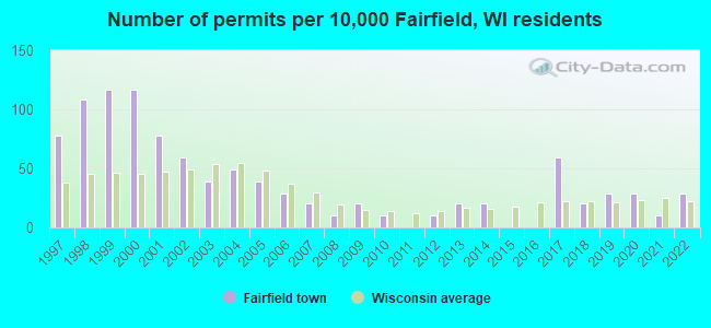
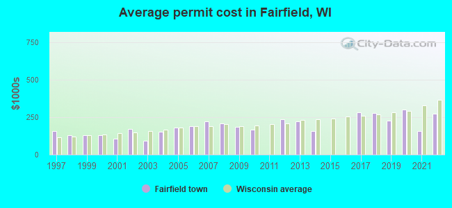
Single-family new house construction building permits:
- 2022: 3 buildings, average cost: $273,300
- 2021: 1 building, cost: $160,000
- 2020: 3 buildings, average cost: $300,000
- 2019: 3 buildings, average cost: $226,000
- 2018: 2 buildings, average cost: $277,500
- 2017: 6 buildings, average cost: $280,800
- 2014: 2 buildings, average cost: $160,000
- 2013: 2 buildings, average cost: $225,000
- 2012: 1 building, cost: $237,000
- 2010: 1 building, cost: $168,000
- 2009: 2 buildings, average cost: $186,000
- 2008: 1 building, cost: $210,000
- 2007: 2 buildings, average cost: $225,000
- 2006: 3 buildings, average cost: $190,000
- 2005: 4 buildings, average cost: $181,300
- 2004: 5 buildings, average cost: $153,000
- 2003: 4 buildings, average cost: $95,000
- 2002: 6 buildings, average cost: $170,300
- 2001: 8 buildings, average cost: $106,400
- 2000: 12 buildings, average cost: $127,700
- 1999: 12 buildings, average cost: $127,700
- 1998: 11 buildings, average cost: $127,700
- 1997: 8 buildings, average cost: $160,400
| Here: | 2.5% |
| Wisconsin: | 2.7% |
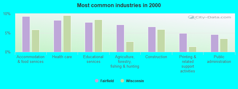
- Accommodation & food services (9.3%)
- Health care (8.3%)
- Educational services (7.8%)
- Agriculture, forestry, fishing & hunting (7.1%)
- Construction (6.6%)
- Printing & related support activities (4.9%)
- Public administration (4.6%)
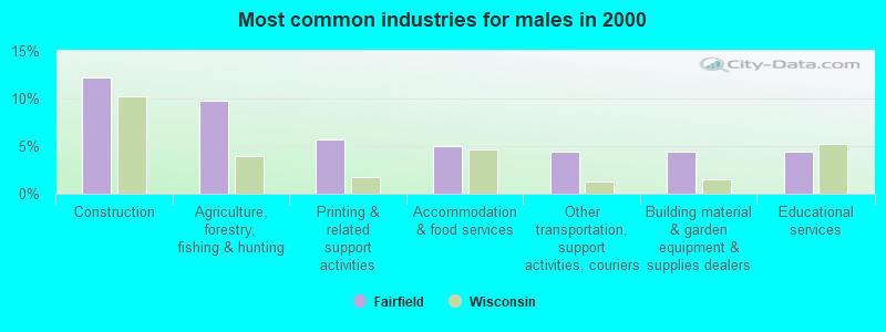
- Construction (12.3%)
- Agriculture, forestry, fishing & hunting (9.7%)
- Printing & related support activities (5.7%)
- Accommodation & food services (5.0%)
- Other transportation, support activities, couriers (4.4%)
- Building material & garden equipment & supplies dealers (4.4%)
- Educational services (4.4%)
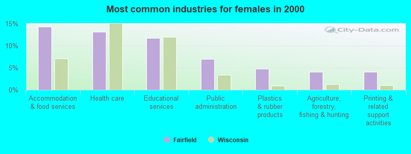
- Accommodation & food services (14.3%)
- Health care (13.2%)
- Educational services (11.7%)
- Public administration (7.0%)
- Plastics & rubber products (4.8%)
- Agriculture, forestry, fishing & hunting (4.0%)
- Printing & related support activities (4.0%)
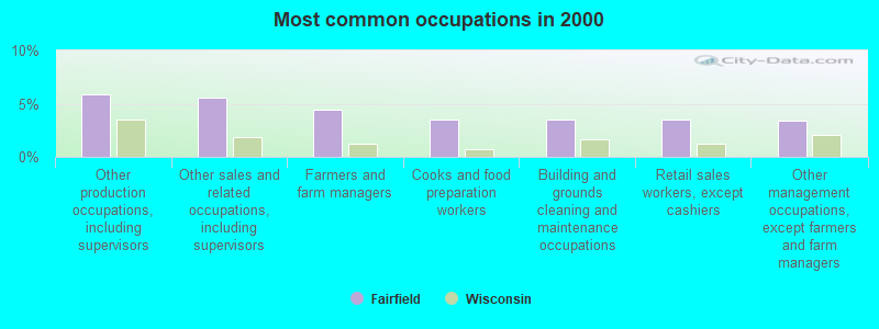
- Other production occupations, including supervisors (5.9%)
- Other sales and related occupations, including supervisors (5.6%)
- Farmers and farm managers (4.4%)
- Cooks and food preparation workers (3.6%)
- Building and grounds cleaning and maintenance occupations (3.6%)
- Retail sales workers, except cashiers (3.6%)
- Other management occupations, except farmers and farm managers (3.4%)
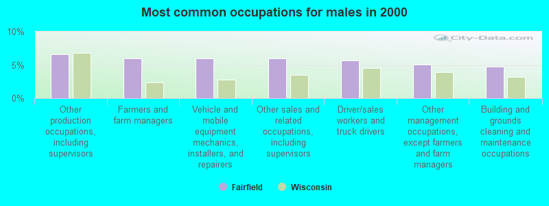
- Other production occupations, including supervisors (6.6%)
- Farmers and farm managers (6.0%)
- Vehicle and mobile equipment mechanics, installers, and repairers (6.0%)
- Other sales and related occupations, including supervisors (6.0%)
- Driver/sales workers and truck drivers (5.7%)
- Other management occupations, except farmers and farm managers (5.0%)
- Building and grounds cleaning and maintenance occupations (4.7%)
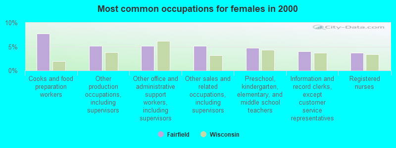
- Cooks and food preparation workers (7.7%)
- Other production occupations, including supervisors (5.1%)
- Other office and administrative support workers, including supervisors (5.1%)
- Other sales and related occupations, including supervisors (5.1%)
- Preschool, kindergarten, elementary, and middle school teachers (4.8%)
- Information and record clerks, except customer service representatives (4.0%)
- Registered nurses (3.7%)
Average climate in Fairfield, Wisconsin
Based on data reported by over 4,000 weather stations


(lower is better)
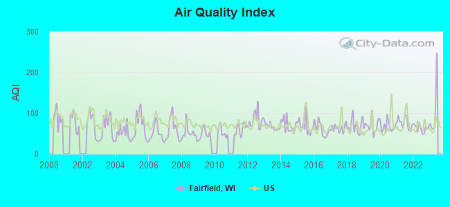
Air Quality Index (AQI) level in 2022 was 63.1. This is about average.
| City: | 63.1 |
| U.S.: | 72.6 |
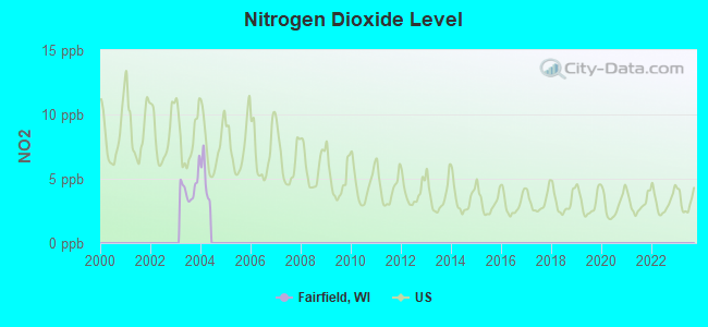
Nitrogen Dioxide (NO2) [ppb] level in 2003 was 4.36. This is about average. Closest monitor was 7.5 miles away from the city center.
| City: | 4.36 |
| U.S.: | 5.11 |
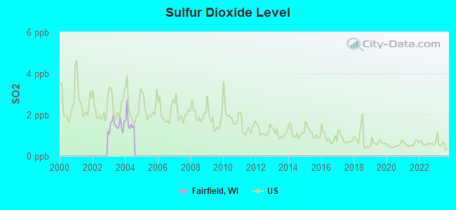
Sulfur Dioxide (SO2) [ppb] level in 2004 was 1.66. This is about average. Closest monitor was 7.5 miles away from the city center.
| City: | 1.66 |
| U.S.: | 1.51 |
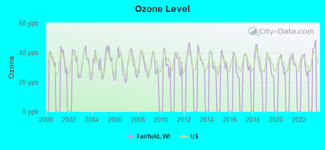
Ozone [ppb] level in 2022 was 32.1. This is about average. Closest monitor was 7.5 miles away from the city center.
| City: | 32.1 |
| U.S.: | 33.3 |
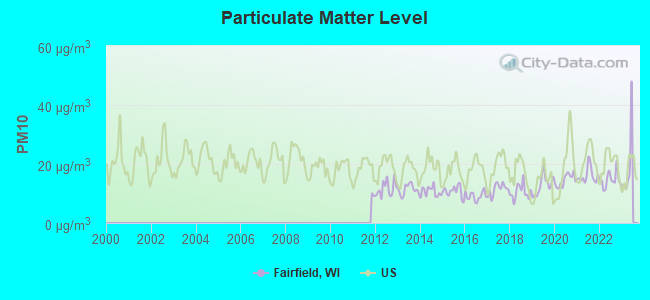
Particulate Matter (PM10) [µg/m3] level in 2022 was 14.7. This is better than average. Closest monitor was 7.5 miles away from the city center.
| City: | 14.7 |
| U.S.: | 19.2 |
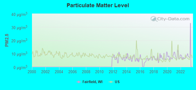
Particulate Matter (PM2.5) [µg/m3] level in 2022 was 7.34. This is about average. Closest monitor was 7.5 miles away from the city center.
| City: | 7.34 |
| U.S.: | 8.11 |
Tornado activity:
Fairfield-area historical tornado activity is above Wisconsin state average. It is 67% greater than the overall U.S. average.
On 6/7/1984, a category F5 (max. wind speeds 261-318 mph) tornado 19.8 miles away from the Fairfield town center killed 9 people and injured 200 people and caused between $50,000 and $500,000 in damages.
On 9/26/1951, a category F4 (max. wind speeds 207-260 mph) tornado 21.8 miles away from the town center killed one person and injured 9 people and caused between $50,000 and $500,000 in damages.
Earthquake activity:
Fairfield-area historical earthquake activity is significantly above Wisconsin state average. It is 28% greater than the overall U.S. average.On 4/18/2008 at 09:36:59, a magnitude 5.4 (5.1 MB, 4.8 MS, 5.4 MW, 5.2 MW, Class: Moderate, Intensity: VI - VII) earthquake occurred 364.3 miles away from Fairfield center
On 6/28/2004 at 06:10:52, a magnitude 4.2 (4.2 MW, Depth: 6.2 mi, Class: Light, Intensity: IV - V) earthquake occurred 149.4 miles away from the city center
On 6/10/1987 at 23:48:54, a magnitude 5.1 (4.9 MB, 4.4 MS, 4.6 MS, 5.1 LG) earthquake occurred 339.6 miles away from the city center
On 4/18/2008 at 09:36:59, a magnitude 5.2 (5.2 MW, Depth: 8.9 mi) earthquake occurred 364.3 miles away from the city center
On 2/10/2010 at 09:59:35, a magnitude 3.8 (3.8 MW, Depth: 6.2 mi, Class: Light, Intensity: II - III) earthquake occurred 124.2 miles away from the city center
On 5/2/2015 at 16:23:07, a magnitude 4.2 (4.2 MW, Depth: 2.8 mi) earthquake occurred 233.3 miles away from the city center
Magnitude types: regional Lg-wave magnitude (LG), body-wave magnitude (MB), surface-wave magnitude (MS), moment magnitude (MW)
Natural disasters:
The number of natural disasters in Sauk County (13) is near the US average (15).Major Disasters (Presidential) Declared: 10
Emergencies Declared: 2
Causes of natural disasters: Floods: 10, Storms: 10, Tornadoes: 6, Winds: 2, Drought: 1, Hurricane: 1, Landslide: 1, Other: 1 (Note: some incidents may be assigned to more than one category).

Hospitals and medical centers near Fairfield:
- ST CLARE DIALYSIS CTR (Dialysis Facility, about 6 miles away; BARABOO, WI)
- ST CLARE HSPTL HLTH SVCS Acute Care Hospitals (about 6 miles away; BARABOO, WI)
- ST CLARE MEADOWS CARE CTR (Nursing Home, about 6 miles away; BARABOO, WI)
- HOME HEALTH UNITED HSPC (Hospital, about 6 miles away; BARABOO, WI)
- RECOVER HEALTH OF WISCONSIN INC (Home Health Center, about 7 miles away; BARABOO, WI)
- SAUK CTY HLTH DEPT (Home Health Center, about 7 miles away; BARABOO, WI)
- CONTINENTAL MANOR OF WIS DELLS (Nursing Home, about 7 miles away; WISCONSIN DELLS, WI)
Amtrak stations near Fairfield:
- 8 miles: WISCONSIN DELLS (LACROSSE ST.) . Services: partially wheelchair accessible, enclosed waiting area, call for taxi service.
- 11 miles: PORTAGE (400 W. ONEIDA ST.) . Services: partially wheelchair accessible, enclosed waiting area, public restrooms, public payphones, free short-term parking, free long-term parking, call for taxi service.
Colleges/universities with over 2000 students nearest to Fairfield:
- Herzing University-Madison (about 34 miles; Madison, WI; Full-time enrollment: 3,160)
- Madison Area Technical College (about 34 miles; Madison, WI; FT enrollment: 9,603)
- University of Wisconsin-Madison (about 36 miles; Madison, WI; FT enrollment: 34,621)
- University of Wisconsin Colleges (about 36 miles; Madison, WI; FT enrollment: 10,019)
- Edgewood College (about 36 miles; Madison, WI; FT enrollment: 2,455)
- Mid-State Technical College (about 59 miles; Wisconsin Rapids, WI; FT enrollment: 2,128)
- Marian University (about 65 miles; Fond Du Lac, WI; FT enrollment: 2,045)
Points of interest:
Notable locations in Fairfield: Pecks Corners (A), Greens Corners (B). Display/hide their locations on the map
Cemetery: Fairfield Cemetery (1). Display/hide its location on the map
Lakes and reservoirs: Chapman Lake (A), Leech Lake (B). Display/hide their locations on the map
Park in Fairfield: Yellow Thunder Park (1). Display/hide its location on the map
| This town: | 2.5 people |
| Wisconsin: | 2.4 people |
| This town: | 74.1% |
| Whole state: | 64.4% |
| This town: | 6.6% |
| Whole state: | 7.3% |
Likely homosexual households (counted as self-reported same-sex unmarried-partner households)
- Lesbian couples: 0.5% of all households
- Gay men: 0.0% of all households
| This town: | 2.0% |
| Whole state: | 8.7% |
| This town: | 1.3% |
| Whole state: | 3.7% |
For population 15 years and over in Fairfield:
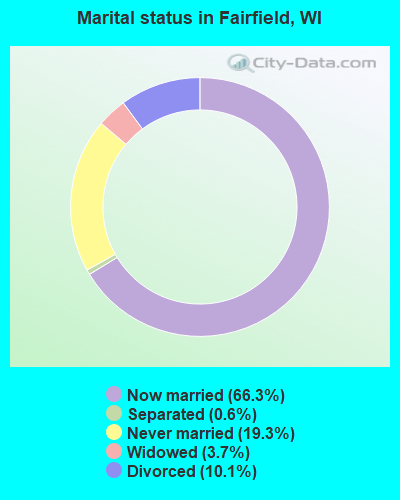
- Never married: 19.3%
- Now married: 66.3%
- Separated: 0.6%
- Widowed: 3.7%
- Divorced: 10.1%
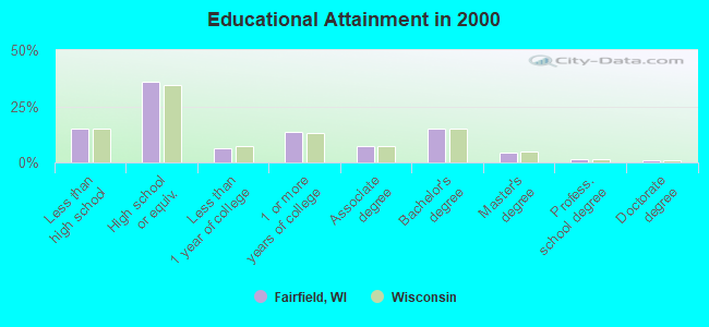
For population 25 years and over in Fairfield:
- High school or higher: 84.8%
- Bachelor's degree or higher: 21.8%
- Graduate or professional degree: 7.0%
- Unemployed: 3.7%
- Mean travel time to work (commute): 20.0 minutes
| Here: | 10.6 |
| Wisconsin average: | 11.0 |
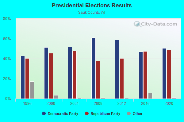
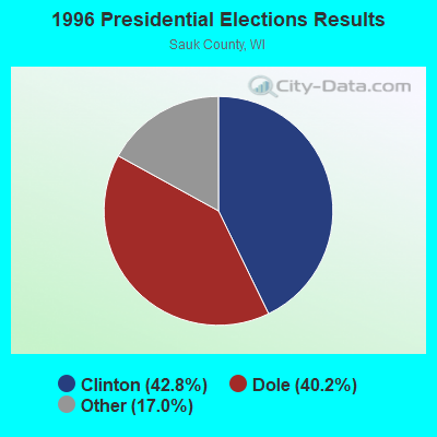
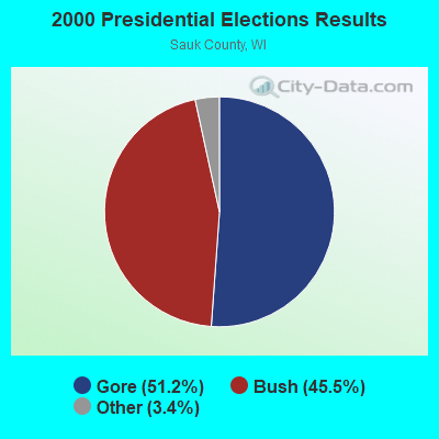
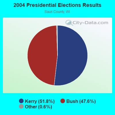
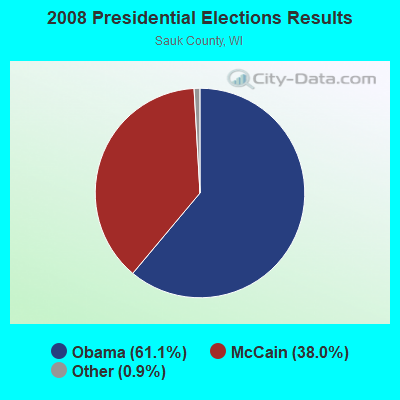
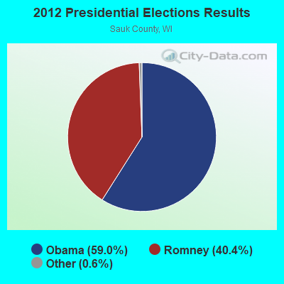
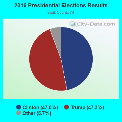
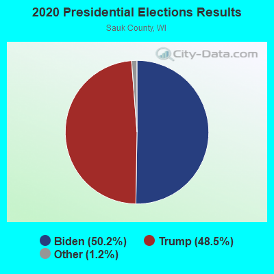
Graphs represent county-level data. Detailed 2008 Election Results
Religion statistics for Fairfield, WI (based on Sauk County data)
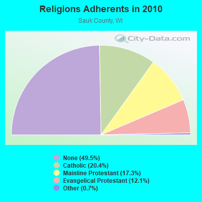
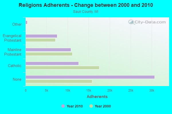
| Religion | Adherents | Congregations |
|---|---|---|
| Catholic | 12,618 | 8 |
| Mainline Protestant | 10,743 | 30 |
| Evangelical Protestant | 7,498 | 40 |
| Other | 436 | 3 |
| None | 30,681 | - |
Food Environment Statistics:
| This county: | 2.74 / 10,000 pop. |
| State: | 1.86 / 10,000 pop. |
| Sauk County: | 0.17 / 10,000 pop. |
| State: | 0.11 / 10,000 pop. |
| Here: | 7.02 / 10,000 pop. |
| Wisconsin: | 4.12 / 10,000 pop. |
| This county: | 13.01 / 10,000 pop. |
| Wisconsin: | 8.64 / 10,000 pop. |
| Sauk County: | 8.1% |
| Wisconsin: | 7.6% |
| Here: | 28.6% |
| Wisconsin: | 27.5% |
| Sauk County: | 18.3% |
| State: | 13.0% |
Strongest AM radio stations in Fairfield:
- WIBU (900 AM; 1 kW; WISCONSIN DELLS, WI; Owner: MAGNUM COMMUNICATIONS, INC.)
- WSPT (1010 AM; 50 kW; STEVENS POINT, WI)
- WNAM (1280 AM; 50 kW; NEENAH-MENASHA, WI; Owner: CUMULUS LICENSING CORP.)
- WTMJ (620 AM; 50 kW; MILWAUKEE, WI; Owner: JOURNAL BROADCAST CORPORATION)
- WRPQ (740 AM; 0 kW; BARABOO, WI; Owner: BARABOO BROADCASTING CORP.)
- WTSO (1070 AM; 10 kW; MADISON, WI; Owner: CAPSTAR TX LIMITED PARTNERSHIP)
- WPDR (1350 AM; 1 kW; PORTAGE, WI; Owner: ZOE COMMUNICATIONS, INC.)
- WISN (1130 AM; 50 kW; MILWAUKEE, WI; Owner: CAPSTAR TX LIMITED PARTNERSHIP)
- WLMV (1480 AM; 10 kW; MADISON, WI; Owner: MID-WEST MANAGEMENT, INC.)
- WHBY (1150 AM; 25 kW; KIMBERLY, WI; Owner: WOODWARD COMMUNICATIONS, INC.)
- WTDY (1670 AM; 10 kW; MADISON, WI; Owner: MID-WEST MANAGEMENT, INC.)
- WSAU (550 AM; 20 kW; WAUSAU, WI; Owner: WRIG, INC.)
- WSCR (670 AM; 50 kW; CHICAGO, IL; Owner: INFINITY BROADCASTING OPERATIONS, INC.)
Strongest FM radio stations in Fairfield:
- WOLX-FM (94.9 FM; BARABOO, WI; Owner: ENTERCOM MADISON LICENSE, LLC.)
- WNNO-FM (106.9 FM; WISCONSIN DELLS, WI; Owner: MAGNUM COMMUNICATIONS, INC.)
- WBKY (95.9 FM; PORTAGE, WI; Owner: MAGNUM COMMUNICATIONS, INC.)
- WDDC (100.1 FM; PORTAGE, WI; Owner: ZOE COMMUNICATIONS, INC.)
- WERN (88.7 FM; MADISON, WI; Owner: STATE OF WISCONSIN - EDUCATIONAL COMMUNICATIONS BOARD)
- WCJZ (96.3 FM; SAUK CITY, WI; Owner: CAPSTAR TX LIMITED PARTNERSHIP)
- WNFM (104.9 FM; REEDSBURG, WI; Owner: NEWRADIO GROUP, LLC)
- WBDL (102.9 FM; REEDSBURG, WI; Owner: NEWRADIO GROUP, LLC)
- WIBA-FM (101.5 FM; MADISON, WI; Owner: CAPSTAR TX LIMITED PARTNERSHIP)
- WZEE (104.1 FM; MADISON, WI; Owner: CAPSTAR TX LIMITED PARTNERSHIP)
- WORT (89.9 FM; MADISON, WI; Owner: BACK PORCH RADIO BROADCASTING, INC.)
- WRJC-FM (92.1 FM; MAUSTON, WI; Owner: WRJC, INCORPORATED)
- W290AL (105.9 FM; BARABOO, WI; Owner: NEWRADIO GROUP, LLC)
TV broadcast stations around Fairfield:
- WISC-TV (Channel 3; MADISON, WI; Owner: TELEVISION WISCONSIN, INC.)
- WMSN-TV (Channel 47; MADISON, WI; Owner: WMSN LICENSEE, LLC)
- WKOW-TV (Channel 27; MADISON, WI; Owner: WKOW TELEVISION, INC.)
- WHA-TV (Channel 21; MADISON, WI; Owner: BOARD OF REGENTS OF THE UNIV. OF WISCONSIN SYSTEM)
- WDLS-LP (Channel 35; TOMAH, WI; Owner: MAGNUM RADIO, INC.)
- WMTV (Channel 15; MADISON, WI; Owner: GRAY MIDAMERICA TV LICENSEE CORP.)
- W58CO (Channel 58; SAULT STE. MARIE, MI; Owner: MS COMMUNICATIONS, LLC)
- National Bridge Inventory (NBI) Statistics
- 11Number of bridges
- 102ft / 30.6mTotal length
- $806,000Total costs
- 153,060Total average daily traffic
- 22,836Total average daily truck traffic
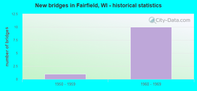
- New bridges - historical statistics
- 11950-1959
- 101960-1969
FCC Registered Cell Phone Towers:
1 (See the full list of FCC Registered Cell Phone Towers in Fairfield)FCC Registered Antenna Towers:
9 (See the full list of FCC Registered Antenna Towers)FCC Registered Microwave Towers:
1- ML15AL194, E13608 County Trunk U (Lat: 43.540806 Lon: -89.642444), Type: Ltower, Structure height: 64 m, Overall height: 67.1 m, Call Sign: WQRF393,
Assigned Frequencies: 10815.0 MHz, Grant Date: 05/01/2013, Expiration Date: 05/01/2023, Cancellation Date: 04/27/2023, Certifier: David Werblow, Registrant: T-Mobile Usa, Inc., 12920 Se 38th Street, Bellevue, WA 98006, Phone: (425) 383-8401, Email:
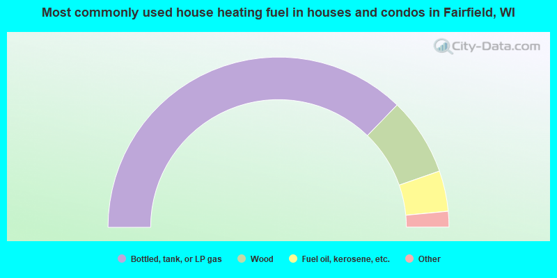
- 74.5%Bottled, tank, or LP gas
- 14.8%Wood
- 7.7%Fuel oil, kerosene, etc.
- 2.4%Electricity
- 0.6%Utility gas
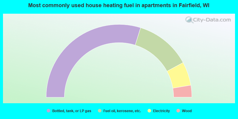
- 59.6%Bottled, tank, or LP gas
- 24.6%Fuel oil, kerosene, etc.
- 10.5%Electricity
- 5.3%Wood
Fairfield compared to Wisconsin state average:
- Unemployed percentage significantly below state average.
- Black race population percentage significantly below state average.
- Hispanic race population percentage significantly below state average.
- Foreign-born population percentage significantly below state average.
- Renting percentage below state average.
- Length of stay since moving in significantly above state average.
- Number of rooms per house significantly below state average.
- House age significantly below state average.