Bridge Statistics for Fairfield, Wisconsin (WI)
Condition, Traffic, Stress, Structural Evaluation, Project Costs
- National Bridge Inventory (NBI) Statistics
- 11Number of bridges
- 102ft / 30.6mTotal length
- $806,000Total costs
- 153,060Total average daily traffic
- 22,836Total average daily truck traffic
- National Bridge Inventory (NBI) Registered Bridges for Fairfield
- No street view available for this location
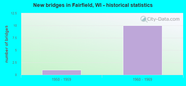
- New bridges - historical statistics
- 11950-1959
- 101960-1969


- Bridge Condition - Deck
- 33.3%Good
- 33.3%Satisfactory
- 16.7%Fair
- 16.7%Poor

- Bridge Condition - Superstructure
- 16.7%Good
- 33.3%Satisfactory
- 33.3%Fair
- 16.7%Poor

- Bridge Condition - Substructure
- 50.0%Good
- 33.3%Satisfactory
- 16.7%Fair
Find on map >> Show street view
Structure Number: B56002, Location: 0.2M E JCT STH 33 (Lat: 43.481514, Lng: -89.636375), Route carried "on" structure: County highway , Year Built: 1956, Status: Open, Structure Length: 4.60m (15.09ft), Average Daily Traffic: 843 (year 2019), Average Future Daily Traffic: 927 (year 2040), Design Load: H 15, Features Intersected: BARABOO RIVER, Facility Carried by Structure: CTH X
Minimum Vertical Clearance: 30+ m (98+ ft), Kilometerpoint: 0.000, Lanes on structure: 2, Owner: County Highway Agency, Approaching Roadway Width: 9.1m (29.9ft), Material/Design: Steel continuous, Design/Construction: Stringer/Multi-beam, Number Of Spans In Main Unit: 3, Length of Maximum Span: 17.1m (56.1ft), Curb-To-Curb Width: 7.3m (24.0ft), Out-to-Out Width: 8.1m (26.6ft)
Condition: Deck: Poor, Superstructure: Poor, Substructure: Satisfactory, Channel: Good, Operating Rating: 31.0 metric tons, Method Used To Determine Operating Rating: Load Factor (LF), Inventory Rating: 17.8 metric tons, Method Used To Determine Inventory Rating: Load Factor (LF), Structural Evaluation: Meets minimum limits, Deck Geometry: Meets minimum limits, Waterway Adequacy: Better than present minimum criteria, Approach Roadway Alignment: Equal to present desirable criteria, Length Of Structure Improvement: 5.06m (16.60ft), Designated Inspection Frequency: Every 12 months, Inspection Date: October 2021, Bridge Improvement Cost: $537,000, Roadway Improvement Cost: $53,000, Total Project Cost: $806,000 ( Estimate for 2021), Deck Structure Type: Concrete Cast-file-Place, Wearing Surface/Protective System: Wearing Surface: Monolithic Concrete
Find on map >> Show street view
Structure Number: B560024, Location: 7.6M E JCT USH 12 TO E (Lat: 43.546678, Lng: -89.636572), Route carried "on" structure: Interstate 90, Year Built: 1961, Year Reconstructed: 1992, Status: Open, Structure Length: 3.36m (11.02ft), Average Daily Traffic: 20,150 (year 2018), Truck Traffic: 18%, Average Future Daily Traffic: 24,180 (year 2038), Design Load: HS 20, Features Intersected: LRD SCHEPP RD
Minimum Vertical Clearance: 30+ m (98+ ft), Kilometerpoint: 0.000, Lanes on structure: 2, Lanes under structure: 2, Base Highway Network: Yes, Owner: State Highway Agency, Approaching Roadway Width: 17.1m (56.1ft), Skew: 1 degrees, Material/Design: Concrete continuous, Design/Construction: Slab, Number Of Spans In Main Unit: 3, Length of Maximum Span: 12.6m (41.3ft), Curb-To-Curb Width: 17.1m (56.1ft), Out-to-Out Width: 17.7m (58.1ft)
Condition: Deck: Satisfactory, Superstructure: Satisfactory, Substructure: Good, Operating Rating: 70.2 metric tons, Method Used To Determine Operating Rating: Load Factor (LF), Inventory Rating: 42.1 metric tons, Method Used To Determine Inventory Rating: Load Factor (LF), Structural Evaluation: Equal to present minimum criteria, Deck Geometry: Superior to present desirable criteria, Underclear: Somewhat better than minimum adequacy, Approach Roadway Alignment: Equal to present desirable criteria, Designated Inspection Frequency: Every 24 months, Inspection Date: August 2020, Deck Structure Type: Concrete Cast-file-Place, Wearing Surface/Protective System: Wearing Surface: Monolithic Concrete, Deck Protection: Epoxy Coated Reinforcing
Find on map >> Show street view
Structure Number: B560025, Location: 6.1M W JCT STH 33 TO E (Lat: 43.547217, Lng: -89.636322), Route carried "on" structure: Interstate 90, Year Built: 1961, Year Reconstructed: 1992, Status: Open, Structure Length: 3.36m (11.02ft), Average Daily Traffic: 20,150 (year 2018), Truck Traffic: 18%, Average Future Daily Traffic: 24,180 (year 2038), Design Load: HS 20, Features Intersected: LRD SCHEPPS RD
Minimum Vertical Clearance: 30+ m (98+ ft), Kilometerpoint: 0.000, Lanes on structure: 2, Lanes under structure: 2, Base Highway Network: Yes, Owner: State Highway Agency, Approaching Roadway Width: 17.1m (56.1ft), Skew: 1 degrees, Material/Design: Concrete continuous, Design/Construction: Slab, Number Of Spans In Main Unit: 3, Length of Maximum Span: 12.6m (41.3ft), Curb-To-Curb Width: 17.1m (56.1ft), Out-to-Out Width: 17.7m (58.1ft)
Condition: Deck: Good, Superstructure: Good, Substructure: Good, Operating Rating: 70.2 metric tons, Method Used To Determine Operating Rating: Load Factor (LF), Inventory Rating: 42.1 metric tons, Method Used To Determine Inventory Rating: Load Factor (LF), Structural Evaluation: Better than present minimum criteria, Deck Geometry: Superior to present desirable criteria, Underclear: Meets minimum limits, Approach Roadway Alignment: Equal to present desirable criteria, Designated Inspection Frequency: Every 24 months, Inspection Date: May 2021, Deck Structure Type: Concrete Cast-file-Place, Wearing Surface/Protective System: Wearing Surface: Monolithic Concrete
Find on map >> Show street view
Structure Number: B560026, Location: 0.5M N JCT CTH U (Lat: 43.548397, Lng: -89.664392), Route carried "on" structure: City street , Year Built: 1961, Status: Open, Structure Length: 6.22m (20.41ft), Average Daily Traffic: 68 (year 2019), Average Future Daily Traffic: 110 (year 2039), Design Load: H 15, Features Intersected: IH 90-IH 94, Facility Carried by Structure: LRD VAN HOOSEN RD
Minimum Vertical Clearance: 30+ m (98+ ft), Kilometerpoint: 0.000, Lanes on structure: 2, Lanes under structure: 4, Owner: State Highway Agency, Approaching Roadway Width: 8.5m (27.9ft), Material/Design: Prestressed concrete, Design/Construction: Stringer/Multi-beam, Number Of Spans In Main Unit: 4, Length of Maximum Span: 20.1m (65.9ft), Curb-To-Curb Width: 7.3m (24.0ft), Out-to-Out Width: 8.5m (27.9ft)
Condition: Deck: Fair, Superstructure: Fair, Substructure: Satisfactory, Operating Rating: 47.4 metric tons, Method Used To Determine Operating Rating: Load Factor (LF), Inventory Rating: 16.2 metric tons, Method Used To Determine Inventory Rating: Load Factor (LF), Structural Evaluation: Somewhat better than minimum adequacy, Deck Geometry: Equal to present minimum criteria, Underclear: Meets minimum limits, Approach Roadway Alignment: Equal to present minimum criteria, Designated Inspection Frequency: Every 24 months, Inspection Date: August 2020, Deck Structure Type: Concrete Cast-file-Place, Wearing Surface/Protective System: Wearing Surface: Monolithic Concrete
Find on map >> Show street view
Structure Number: B560028, Location: 0.7M N JCT CTH U (Lat: 43.550725, Lng: -89.684431), Route carried "on" structure: County highway , Year Built: 1961, Status: Open, Structure Length: 6.53m (21.42ft), Average Daily Traffic: 156 (year 2019), Average Future Daily Traffic: 429 (year 2039), Design Load: H 15, Features Intersected: IH 90-IH 94, Facility Carried by Structure: CTH T
Minimum Vertical Clearance: 30+ m (98+ ft), Kilometerpoint: 0.000, Lanes on structure: 2, Lanes under structure: 4, Owner: State Highway Agency, Approaching Roadway Width: 10.4m (34.1ft), Skew: 1 degrees, Material/Design: Prestressed concrete, Design/Construction: Stringer/Multi-beam, Number Of Spans In Main Unit: 4, Length of Maximum Span: 21.0m (68.9ft), Curb-To-Curb Width: 7.9m (25.9ft), Out-to-Out Width: 8.7m (28.5ft)
Condition: Deck: Satisfactory, Superstructure: Fair, Substructure: Fair, Operating Rating: 45.7 metric tons, Method Used To Determine Operating Rating: Load Factor (LF), Inventory Rating: 16.2 metric tons, Method Used To Determine Inventory Rating: Load Factor (LF), Structural Evaluation: Somewhat better than minimum adequacy, Deck Geometry: Somewhat better than minimum adequacy, Underclear: Meets minimum limits, Approach Roadway Alignment: Equal to present desirable criteria, Designated Inspection Frequency: Every 24 months, Inspection Date: August 2020, Deck Structure Type: Concrete Cast-file-Place, Wearing Surface/Protective System: Wearing Surface: Low Slump Concrete
Find on map >> Show street view
Structure Number: B560029, Location: 0.3M S JCT CTH T (Lat: 43.559008, Lng: -89.718619), Route carried "on" structure: City street , Year Built: 1960, Status: Open, Structure Length: 6.55m (21.49ft), Average Daily Traffic: 113 (year 2019), Average Future Daily Traffic: 110 (year 2040), Design Load: H 15, Features Intersected: IH 90-IH 94, Facility Carried by Structure: LRD GILLEM RD
Minimum Vertical Clearance: 30+ m (98+ ft), Kilometerpoint: 0.000, Lanes on structure: 2, Lanes under structure: 4, Owner: State Highway Agency, Approaching Roadway Width: 7.3m (24.0ft), Skew: 2 degrees, Material/Design: Prestressed concrete, Design/Construction: Stringer/Multi-beam, Number Of Spans In Main Unit: 4, Length of Maximum Span: 21.3m (69.9ft), Curb-To-Curb Width: 7.3m (24.0ft), Out-to-Out Width: 8.1m (26.6ft)
Condition: Deck: Good, Superstructure: Satisfactory, Substructure: Good, Operating Rating: 39.2 metric tons, Method Used To Determine Operating Rating: Load Factor (LF), Inventory Rating: 16.2 metric tons, Method Used To Determine Inventory Rating: Load Factor (LF), Structural Evaluation: Somewhat better than minimum adequacy, Deck Geometry: Somewhat better than minimum adequacy, Underclear: Meets minimum limits, Approach Roadway Alignment: Equal to present desirable criteria, Designated Inspection Frequency: Every 24 months, Inspection Date: May 2021, Deck Structure Type: Concrete Cast-file-Place, Wearing Surface/Protective System: Wearing Surface: Low Slump Concrete
Find on map >> Show street view
Structure Number: B560024, Location: 0.6M N JCT CTH U (Lat: 43.546678, Lng: -89.636572), Route carried "under" structure: City street , Year Built: 1961, Structure Length: 0. m, Average Daily Traffic: 140 (year 2019), Features Intersected: LRD SCHEPP RD, Facility Carried by Structure: IH 90 EB-IH 94 EB
Minimum Vertical Clearance: 4.37m (14.34ft), Kilometerpoint: 0.000, Lanes on structure: 2, Lanes under structure: 2, Material/Design: Concrete continuous, Design/Construction: Slab, Length of Maximum Span: 12.6m (41.3ft)
Find on map >> Show street view
Structure Number: B560025, Location: 0.6M N JCT CTH U (Lat: 43.547217, Lng: -89.636322), Route carried "under" structure: City street , Year Built: 1961, Structure Length: 0. m, Average Daily Traffic: 140 (year 2019), Features Intersected: LRD SCHEPPS RD, Facility Carried by Structure: IH 90 WB-IH 94 WB
Minimum Vertical Clearance: 4.42m (14.50ft), Kilometerpoint: 0.000, Lanes on structure: 2, Lanes under structure: 2, Material/Design: Concrete continuous, Design/Construction: Slab, Length of Maximum Span: 12.6m (41.3ft)
Find on map >> Show street view
Structure Number: B560026, Location: 6.2M E JCT USH 12 TO E (Lat: 43.548397, Lng: -89.664392), Route carried "under" structure: Interstate 90, Year Built: 1961, Structure Length: 0. m, Average Daily Traffic: 37,100 (year 2019), Truck Traffic: 14%, Features Intersected: IH 90-IH 94, Facility Carried by Structure: LRD VAN HOOSEN RD
Minimum Vertical Clearance: 5.11m (16.77ft), Kilometerpoint: 0.000, Lanes on structure: 2, Lanes under structure: 4, Material/Design: Prestressed concrete, Design/Construction: Stringer/Multi-beam, Length of Maximum Span: 20.1m (65.9ft)
Find on map >> Show street view
Structure Number: B560028, Location: 5.2M E JCT USH 12 TO E (Lat: 43.550725, Lng: -89.684431), Route carried "under" structure: Interstate 90, Year Built: 1961, Structure Length: 0. m, Average Daily Traffic: 37,100 (year 2019), Truck Traffic: 14%, Features Intersected: IH 90-IH 94, Facility Carried by Structure: CTH T
Minimum Vertical Clearance: 5.14m (16.86ft), Kilometerpoint: 0.000, Lanes on structure: 2, Lanes under structure: 4, Material/Design: Prestressed concrete, Design/Construction: Stringer/Multi-beam, Length of Maximum Span: 21.0m (68.9ft)
Find on map >> Show street view
Structure Number: B560029, Location: 3.4M E JCT USH 12 TO E (Lat: 43.559008, Lng: -89.718619), Route carried "under" structure: Interstate 90, Year Built: 1960, Structure Length: 0. m, Average Daily Traffic: 37,100 (year 2019), Truck Traffic: 14%, Features Intersected: IH 90-IH 94, Facility Carried by Structure: LRD GILLEM RD
Minimum Vertical Clearance: 5.09m (16.70ft), Kilometerpoint: 0.000, Lanes on structure: 2, Lanes under structure: 4, Material/Design: Prestressed concrete, Design/Construction: Stringer/Multi-beam, Length of Maximum Span: 21.3m (69.9ft)