Death Valley, California
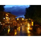
Death Valley: December Rain Dampens Stovepipe Wells Village
Death Valley: Stovepipe Wells Village
- add
your
Submit your own pictures of this place and show them to the world
- OSM Map
- General Map
- Google Map
- MSN Map

| Males: 325 | |
| Females: 295 |
| Median resident age: | 46.0 years |
| California median age: | 33.3 years |
Zip code: 92384
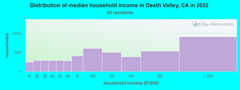
| Death Valley: | $64,741 |
| CA: | $91,551 |
Estimated per capita income in 2022: $41,433 (it was $21,679 in 2000)
Death Valley CCD income, earnings, and wages data
Estimated median house or condo value in 2022: $83,719 (it was $30,400 in 2000)
| Death Valley: | $83,719 |
| CA: | $715,900 |
Detailed information about poverty and poor residents in Death Valley, CA
Compare current foreclosures near Death Valley, CA:
| Photo | Address | Area | Beds / Baths | Price | Details |
|---|---|---|---|---|---|

|
#1
SE Clifftop Drive
Pahrump, NV 89061
|
1,470 sq. feet
|
2 baths 2 beds |
show details | |

|
#2
Summerwood St
Pahrump, NV 89048
|
1,031 sq. feet
|
2 baths 2 beds |
show details | |

|
#3
Francine St
Pahrump, NV 89060
|
3,490 sq. feet
|
3 baths 4 beds |
show details | |

|
#4
E Falcon St
Pahrump, NV 89048
|
- sq. feet
|
2 baths 3 beds |
show details | |

|
#5
White St
Pahrump, NV 89060
|
- sq. feet
|
- baths - beds |
show details | |

|
#6
E Florence Ave
Pahrump, NV 89061
|
- sq. feet
|
- baths - beds |
show details | |

|
#7
E Summit Ave
Pahrump, NV 89061
|
- sq. feet
|
- baths - beds |
show details | |

|
#8
E Deerskin St
Pahrump, NV 89048
|
- sq. feet
|
- baths - beds |
show details | |

|
#9
W Irene St
Pahrump, NV 89060
|
- sq. feet
|
- baths - beds |
show details | |

|
#10
Peppertree St
Pahrump, NV 89061
|
- sq. feet
|
- baths - beds |
show details |
| Photo | Address | Area | Beds / Baths | Price | Details |
|---|---|---|---|---|---|

|
#11
Marywood Ct
Pahrump, NV 89061
|
2,143 sq. feet
|
- baths - beds |
show details | |

|
#12
Balhurst Ct
Pahrump, NV 89061
|
3,128 sq. feet
|
- baths - beds |
show details | |

|
#13
S Rainbow Ave
Pahrump, NV 89048
|
2,269 sq. feet
|
- baths - beds |
show details | |

|
#14
Applewood Ct
Pahrump, NV 89061
|
2,327 sq. feet
|
- baths - beds |
show details | |

|
#15
National Ave
Pahrump, NV 89048
|
1,979 sq. feet
|
- baths - beds |
show details | |

|
#16
National Ave
Pahrump, NV 89048
|
1,676 sq. feet
|
- baths - beds |
show details | |

|
#17
Ellendale St
Pahrump, NV 89048
|
1,128 sq. feet
|
- baths - beds |
show details | |

|
#18
N Blagg Rd
Pahrump, NV 89060
|
- sq. feet
|
- baths - beds |
show details | |

|
#19
S Nevada Highway 160, Ste 8
Pahrump, NV 89048
|
- sq. feet
|
- baths - beds |
show details | |

|
#20
Lorenzo Way
Pahrump, NV 89061
|
- sq. feet
|
- baths - beds |
show details |
| Photo | Address | Area | Beds / Baths | Price | Details |
|---|---|---|---|---|---|

|
#21
Monte Penne Way
Pahrump, NV 89061
|
- sq. feet
|
- baths - beds |
show details | |

|
#22
Front Sight Rd
Pahrump, NV 89061
|
- sq. feet
|
- baths - beds |
show details | |

|
#23
Via Vinci Ct
Pahrump, NV 89061
|
- sq. feet
|
- baths - beds |
show details | |

|
#24
Janet Ln
Pahrump, NV 89060
|
1,693 sq. feet
|
- baths - beds |
show details | |

|
#25
N Linda St
Pahrump, NV 89060
|
1,378 sq. feet
|
- baths - beds |
show details | |

|
#26
S Larimer St
Pahrump, NV 89061
|
- sq. feet
|
- baths - beds |
show details | |

|
#27
Z St
Pahrump, NV 89048
|
912 sq. feet
|
- baths - beds |
show details | |

|
#28
S Woodchips Rd
Pahrump, NV 89048
|
- sq. feet
|
- baths - beds |
show details | |

|
#29
Fountain Ave
Pahrump, NV 89048
|
1,587 sq. feet
|
- baths - beds |
show details | |

|
#30
Flamingo Rd
Pahrump, NV 89048
|
2,160 sq. feet
|
- baths - beds |
show details |
| Photo | Address | Area | Beds / Baths | Price | Details |
|---|---|---|---|---|---|

|
#31
Carnation Way Unit 2
Pahrump, NV 89048
|
- sq. feet
|
- baths - beds |
show details | |

|
#32
Fremont St
Pahrump, NV 89048
|
1,483 sq. feet
|
- baths - beds |
show details | |

|
#33
Jacob St
Pahrump, NV 89048
|
1,904 sq. feet
|
- baths - beds |
show details | |

|
#34
Fritz Ln
Pahrump, NV 89048
|
2,604 sq. feet
|
- baths - beds |
show details | |

|
#35
China St
Pahrump, NV 89048
|
1,987 sq. feet
|
- baths - beds |
show details | |

|
#36
Windy Ln
Pahrump, NV 89048
|
1,058 sq. feet
|
- baths - beds |
show details | |

|
#37
Oakridge Ave
Pahrump, NV 89048
|
1,742 sq. feet
|
- baths - beds |
show details | |

|
#38
Corrine St
Pahrump, NV 89048
|
- sq. feet
|
- baths - beds |
show details | |

|
#39
Amarillo Ave
Pahrump, NV 89048
|
- sq. feet
|
- baths - beds |
show details | |

|
#40
S Bannavitch St
Pahrump, NV 89048
|
- sq. feet
|
- baths - beds |
show details |
| Photo | Address | Area | Beds / Baths | Price | Details |
|---|---|---|---|---|---|

|
#41
Fountain Ave
Pahrump, NV 89048
|
- sq. feet
|
- baths - beds |
show details | |

|
#42
Garden Ln
Pahrump, NV 89048
|
2,234 sq. feet
|
- baths - beds |
show details | |

|
#43
Money St
Pahrump, NV 89048
|
- sq. feet
|
- baths - beds |
show details | |

|
#44
Mcgraw Rd
Pahrump, NV 89061
|
2,675 sq. feet
|
- baths - beds |
show details | |

|
#45
Yakima Ave
Pahrump, NV 89048
|
- sq. feet
|
- baths - beds |
show details | |

|
#46
Homestead Rd
Pahrump, NV 89048
|
- sq. feet
|
- baths - beds |
show details | |

|
#47
Heritage Dr
Pahrump, NV 89048
|
- sq. feet
|
- baths - beds |
show details | |

|
#48
W Dyer Rd
Pahrump, NV 89048
|
2,377 sq. feet
|
- baths - beds |
show details | |

|
#49
Oakridge Ave
Pahrump, NV 89048
|
17,792 sq. feet
|
- baths - beds |
show details | |

|
Check over 1 million property listings on Foreclosure.com!
|
browse all offers | |||

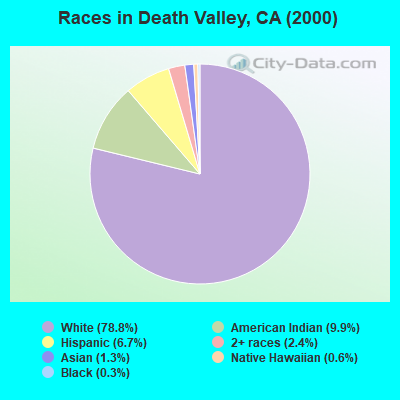
- 50378.8%White alone
- 639.9%American Indian alone
- 436.7%Hispanic
- 152.4%Two or more races
- 81.3%Asian alone
- 40.6%Native Hawaiian and Other
Pacific Islander alone - 20.3%Black alone
 Recent articles from our blog. Our writers, many of them Ph.D. graduates or candidates, create easy-to-read articles on a wide variety of topics.
Current Local Time: PST time zone
Land area: 4713.3 square miles.
Population density: 0.1 people per square mile (very low).
| Death Valley CCD: | 1.6% ($500) |
| California: | 0.8% ($1,564) |
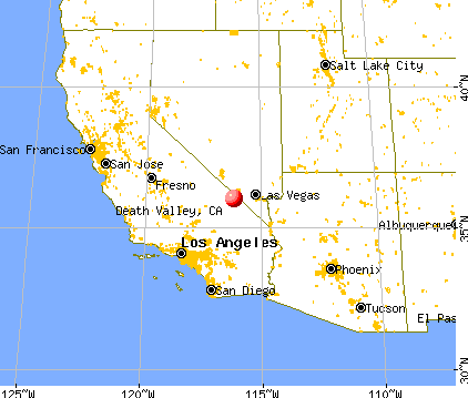
Nearest city with pop. 50,000+: Spring Valley, NV (51.9 miles  , pop. 117,390).
Nearest city with pop. 200,000+: Las Vegas, NV (54.2 miles , pop. 478,434).
Nearest city with pop. 1,000,000+: Los Angeles, CA (183.7 miles , pop. 3,694,820).
Nearest cities:
), Latitude: 36.04 N, Longitude: 116.17 W
Area code: 760

Death Valley tourist attractions:
- Amargosa Opera House - Death Valley National Park, California - Opera House and Hotel
- Artist's Drive
- Artist's Palette
- Badwater Basin
- Ballarat Ghost Town
- Barker Ranch
- Dante's View
- Wildrose Charcoal Kilns
- Devil's Golf Course
- Scotty's Castle
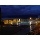
- Stovepipe Wells Village
- Zabriskie Point
- Borax Museum
- Briggs Mine
- Cerro Gordo
- Daylight Pass
- Daylight Pass
- Eureka Dunes
- Funeral Mountains Death Valley National Park
- Funeral Mountains
- Geologist's Cabin
- Ghost Town of Schwab
- Ghost Town of Schwab
- Golden Canyon
- Harmony Borax Works
- Keane Wonder Mine
- Keane Wonder Mine
- Keystone Mine
- Lippincott Mine Road
- Lippincott Mine Road
- Mengel Pass
- Panamint Mountains
- Racetrack
- The Racetrack Death Valley Junction
- Titus Canyon
- Ubehebe Crater
- Warm Springs Mines
- Red Pass Death Valley Junction
- Red Pass
- Twenty Mule Team Canyon
- Twenty Mule Team Canyon
- Furnace Creek Inn and Ranch Resort
| Here: | 4.2% |
| California: | 5.1% |
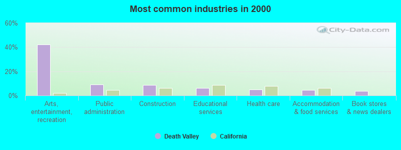
- Arts, entertainment, recreation (42.0%)
- Public administration (9.1%)
- Construction (8.8%)
- Educational services (6.2%)
- Health care (4.9%)
- Accommodation & food services (4.6%)
- Book stores & news dealers (3.6%)
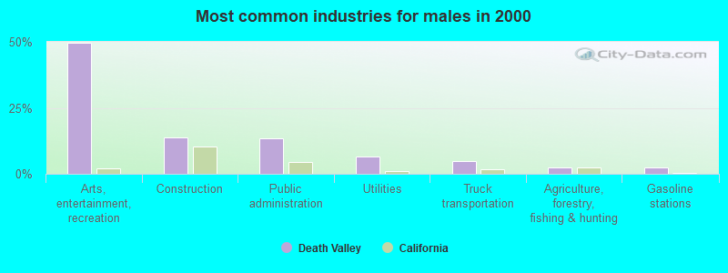
- Arts, entertainment, recreation (49.7%)
- Construction (13.9%)
- Public administration (13.3%)
- Utilities (6.7%)
- Truck transportation (4.8%)
- Agriculture, forestry, fishing & hunting (2.4%)
- Gasoline stations (2.4%)
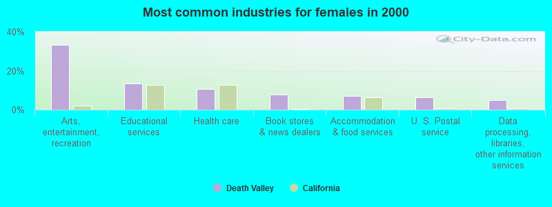
- Arts, entertainment, recreation (33.1%)
- Educational services (13.4%)
- Health care (10.6%)
- Book stores & news dealers (7.7%)
- Accommodation & food services (7.0%)
- U. S. Postal service (6.3%)
- Data processing, libraries, other information services (4.9%)
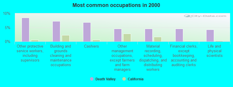
- Other protective service workers, including supervisors (8.5%)
- Building and grounds cleaning and maintenance occupations (7.2%)
- Cashiers (6.8%)
- Other management occupations, except farmers and farm managers (4.6%)
- Material recording, scheduling, dispatching, and distributing workers (4.6%)
- Financial clerks, except bookkeeping, accounting and auditing clerks (4.6%)
- Life and physical scientists (4.2%)
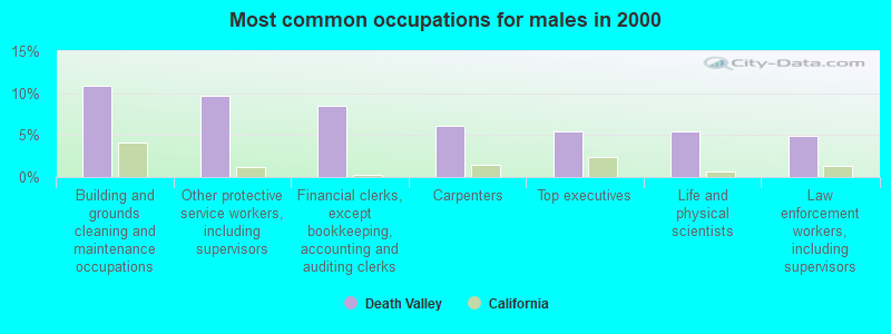
- Building and grounds cleaning and maintenance occupations (10.9%)
- Other protective service workers, including supervisors (9.7%)
- Financial clerks, except bookkeeping, accounting and auditing clerks (8.5%)
- Carpenters (6.1%)
- Top executives (5.5%)
- Life and physical scientists (5.5%)
- Law enforcement workers, including supervisors (4.8%)
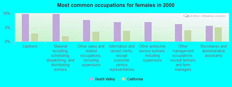
- Cashiers (9.9%)
- Material recording, scheduling, dispatching, and distributing workers (9.9%)
- Other sales and related occupations, including supervisors (7.7%)
- Information and record clerks, except customer service representatives (7.0%)
- Other protective service workers, including supervisors (7.0%)
- Other management occupations, except farmers and farm managers (6.3%)
- Secretaries and administrative assistants (5.6%)
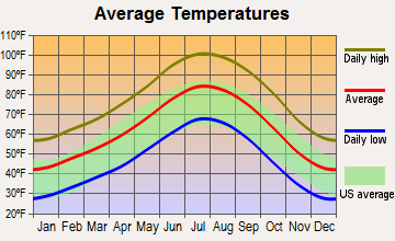
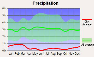
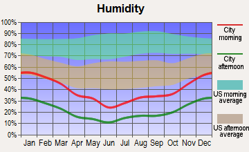
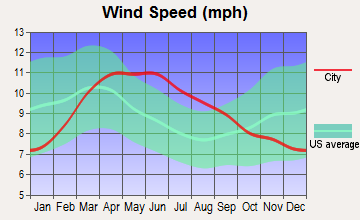
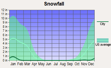
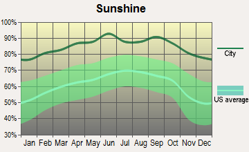
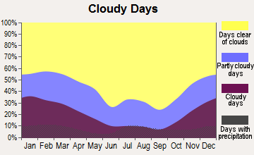
Average climate in Death Valley, California
Based on data reported by over 4,000 weather stations
(lower is better)
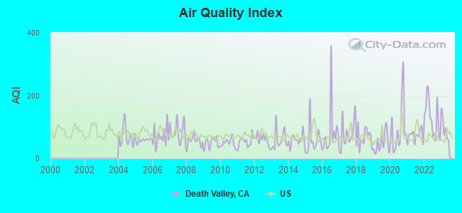
Air Quality Index (AQI) level in 2022 was 128. This is significantly worse than average.
| City: | 128 |
| U.S.: | 73 |
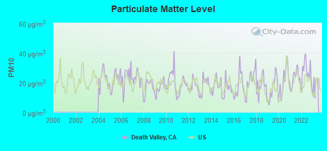
Particulate Matter (PM10) [µg/m3] level in 2022 was 27.6. This is significantly worse than average. Closest monitor was 13.0 miles away from the city center.
| City: | 27.6 |
| U.S.: | 19.2 |
Earthquake activity:
Death Valley-area historical earthquake activity is significantly above California state average. It is 7077% greater than the overall U.S. average.On 6/28/1992 at 11:57:34, a magnitude 7.6 (6.2 MB, 7.6 MS, 7.3 MW, Depth: 0.7 mi, Class: Major, Intensity: VIII - XII) earthquake occurred 129.8 miles away from the city center, causing 3 deaths (1 shaking deaths, 2 other deaths) and 400 injuries, causing $100,000,000 total damage and $40,000,000 insured losses
On 7/21/1952 at 11:52:14, a magnitude 7.7 (7.7 UK) earthquake occurred 174.5 miles away from Death Valley center, causing $50,000,000 total damage
On 10/16/1999 at 09:46:44, a magnitude 7.4 (6.3 MB, 7.4 MS, 7.2 MW, 7.3 ML) earthquake occurred 106.3 miles away from Death Valley center
On 5/19/1940 at 04:36:40, a magnitude 7.2 (7.2 UK) earthquake occurred 196.6 miles away from the city center, causing $33,000,000 total damage
On 6/28/1992 at 15:05:30, a magnitude 6.9 (6.3 MB, 6.7 MS, 6.5 MW, 6.9 ME, Depth: 3.1 mi, Class: Strong, Intensity: VII - IX) earthquake occurred 126.3 miles away from the city center
On 12/21/1932 at 06:10:09, a magnitude 7.2 (7.2 UK) earthquake occurred 200.8 miles away from the city center
Magnitude types: body-wave magnitude (MB), energy magnitude (ME), local magnitude (ML), surface-wave magnitude (MS), moment magnitude (MW)
Natural disasters:
The number of natural disasters in Inyo County (11) is smaller than the US average (15).Major Disasters (Presidential) Declared: 5
Emergencies Declared: 2
Causes of natural disasters: Floods: 7, Winter Storms: 4, Mudslides: 3, Storms: 3, Drought: 1, Fire: 1, Hurricane: 1, Landslide: 1, Other: 1 (Note: some incidents may be assigned to more than one category).
Hospitals and medical centers near Death Valley:
- PAHRUMP HEALTH AND REHABILITATION CENTER (Nursing Home, about 13 miles away; PAHRUMP, NV)
- PAHRUMP DIALYSIS CENTER (DVA) (Dialysis Facility, about 15 miles away; PAHRUMP, NV)
- DESERT VIEW REGIONAL MEDICAL CENTER (Hospital, about 15 miles away; PAHRUMP, NV)
- NATHAN ADELSON HOSPICE-PAHRUMP (Hospital, about 15 miles away; PAHRUMP, NV)
Colleges/universities with over 2000 students nearest to Death Valley:
- College of Southern Nevada (about 54 miles; Las Vegas, NV; Full-time enrollment: 18,996)
- University of Nevada-Las Vegas (about 58 miles; Las Vegas, NV; FT enrollment: 21,153)
- Nevada State College (about 70 miles; Henderson, NV; FT enrollment: 2,346)
- Cerro Coso Community College (about 90 miles; Ridgecrest, CA; FT enrollment: 2,420)
- Barstow Community College (about 94 miles; Barstow, CA; FT enrollment: 2,120)
- Victor Valley College (about 125 miles; Victorville, CA; FT enrollment: 7,630)
- Mohave Community College (about 132 miles; Kingman, AZ; FT enrollment: 3,309)
Points of interest:
Notable locations in Death Valley: Hog Ranch (A), Hungry Bills Ranch (B), Indian Ranch (C), Stovepipe Wells (D), Mclain Park (E), Emigrant Ranger Station (F), Mushroom Rock (G), Myers Ranch (H), Russell Camp (I), Stone Corral (J), Confidence Mill (K), National Park Service Headquarters (L), Texas Springs Campground (M), Thompson Camp (N), Thorndike Campground (O), Mesquite Spring Campground (P), Wildrose Ranger Station (Q), Wilson Ranch (R), Death Valley (S), West Side Borax Camp (T). Display/hide their locations on the map
Cemeteries: Dayton Harris Grave Monument (1), Jean Lemoigne Grave (2). Display/hide their locations on the map
Lakes and swamps: Grimshaw Lake (A), Cottonball Marsh (B). Display/hide their locations on the map
Streams, rivers, and creeks: Emigrant Wash (A), Cow Creek (B), Confidence Wash (C), Little Grapevine Creek (D), Bradbury Wash (E), Jubilee Wash (F), Tecopa Wash (G), Potosi Wash (H), Fortymile Wash (I). Display/hide their locations on the map
Parks in Death Valley include: Death Valley National Park (1), Tecopa Hot Springs County Park (2), Death Valley Junction Historic District (3). Display/hide their locations on the map
Drinking water stations with addresses in Death Valley that have no violations reported:
- NPS - DEATH VALLEY, SCOTTY S CASTLE (Population served: 850, Primary Water Source Type: Groundwater)
- NPS - DEATH VALLEY, EMIGRANT RA/CG (Population served: 150, Primary Water Source Type: Groundwater)
- NPS - DEATH VALLEY, MESQUITE SPRINGS (Population served: 35, Primary Water Source Type: Groundwater)
- NPS - DEATH VALLEY, WILDROSE CMPGD (Population served: 35, Primary Water Source Type: Groundwater)
| This place: | 1.7 people |
| California: | 2.9 people |
| This place: | 33.3% |
| Whole state: | 68.7% |
| This place: | 7.8% |
| Whole state: | 7.2% |
Likely homosexual households (counted as self-reported same-sex unmarried-partner households)
- Lesbian couples: 0.2% of all households
- Gay men: 0.7% of all households
| This place: | 12.6% |
| Whole state: | 14.2% |
| This place: | 1.3% |
| Whole state: | 6.3% |
For population 15 years and over in Death Valley:
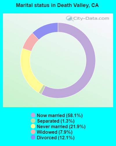
- Never married: 21.9%
- Now married: 58.1%
- Separated: 1.3%
- Widowed: 7.9%
- Divorced: 12.1%
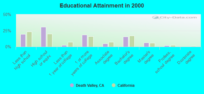
For population 25 years and over in Death Valley:
- High school or higher: 80.7%
- Bachelor's degree or higher: 23.9%
- Graduate or professional degree: 8.2%
- Unemployed: 8.9%
- Mean travel time to work (commute): 10.1 minutes
| Here: | 11.2 |
| California average: | 16.1 |
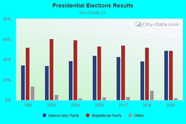
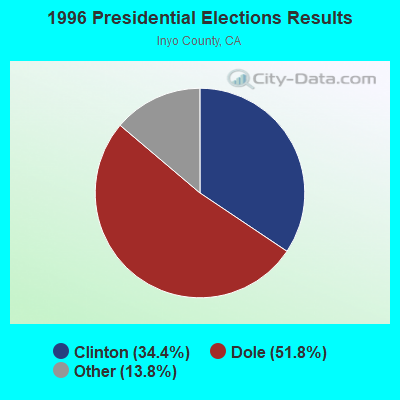
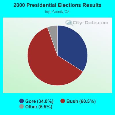
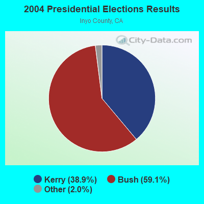
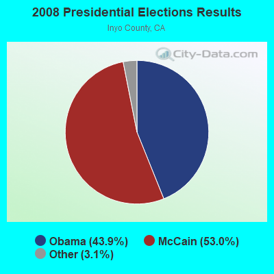
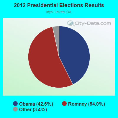
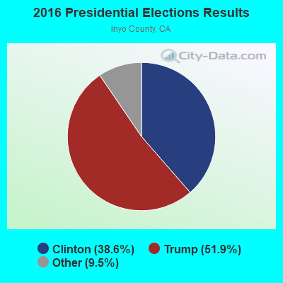
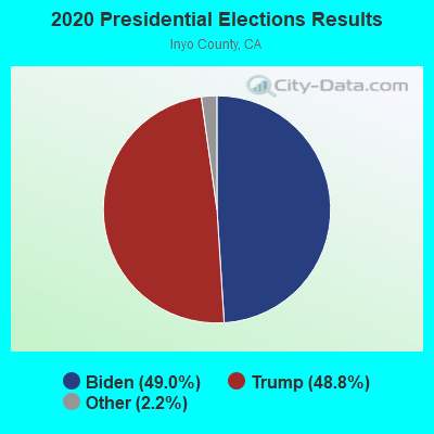
Graphs represent county-level data. Detailed 2008 Election Results
Religion statistics for Death Valley, CA (based on Inyo County data)
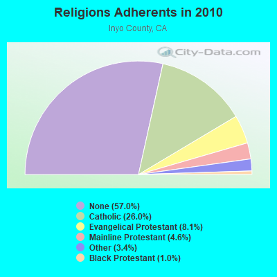

| Religion | Adherents | Congregations |
|---|---|---|
| Catholic | 4,827 | 5 |
| Evangelical Protestant | 1,494 | 23 |
| Mainline Protestant | 845 | 5 |
| Other | 629 | 4 |
| Black Protestant | 178 | 1 |
| None | 10,573 | - |
Food Environment Statistics:
| This county: | 3.45 / 10,000 pop. |
| California: | 2.14 / 10,000 pop. |
| This county: | 0.57 / 10,000 pop. |
| State: | 0.62 / 10,000 pop. |
| Inyo County: | 9.77 / 10,000 pop. |
| State: | 1.49 / 10,000 pop. |
| Inyo County: | 16.67 / 10,000 pop. |
| California: | 7.42 / 10,000 pop. |
| This county: | 8.1% |
| California: | 7.3% |
| Inyo County: | 23.1% |
| California: | 21.3% |
| This county: | 13.9% |
| California: | 17.9% |
Strongest AM radio stations in Death Valley:
- KDWN (720 AM; 50 kW; LAS VEGAS, NV; Owner: RADIO NEVADA CORP.)
- KXNT (840 AM; 50 kW; NORTH LAS VEGAS, NV; Owner: INFINITY RADIO OPERATIONS INC.)
- KLAC (570 AM; 50 kW; LOS ANGELES, CA; Owner: AMFM RADIO LICENSES, L.L.C.)
- KMJ (580 AM; 50 kW; FRESNO, CA; Owner: INFINITY RADIO OPERATIONS INC.)
- KLSQ (870 AM; 10 kW; WHITNEY, NV; Owner: KLSQ-AM LICENSE CORPORATION)
- KFI (640 AM; 50 kW; LOS ANGELES, CA; Owner: CAPSTAR TX LIMITED PARTNERSHIP)
- KENO (1460 AM; 10 kW; LAS VEGAS, NV; Owner: LOTUS BROADCASTING CORP.)
- KIRN (670 AM; 35 kW; SIMI VALLEY, CA; Owner: LOTUS OXNARD CORP.)
- KPLS (830 AM; 50 kW; ORANGE, CA; Owner: CRN LICENSES, LLC)
- KSFN (1140 AM; 10 kW; NORTH LAS VEGAS, NV; Owner: INFINITY RADIO OPERATIONS INC.)
- KSPN (710 AM; 50 kW; LOS ANGELES, CA; Owner: KABC-AM RADIO, INC.)
- KNUU (970 AM; 5 kW; PARADISE, NV; Owner: NEVADA MEDIA GROUP, INC.)
- KKVV (1060 AM; 5 kW; LAS VEGAS, NV; Owner: LAS VEGAS BROADCASTERS, INC.)
Strongest FM radio stations in Death Valley:
- KQOL-FM (93.1 FM; LAS VEGAS, NV; Owner: CITICASTERS LICENSES, L.P.)
- KXTE (107.5 FM; PAHRUMP, NV; Owner: INFINITY RADIO OPERATIONS INC.)
- KOMP (92.3 FM; LAS VEGAS, NV; Owner: LOTUS BROADCASTING CORP.)
- KQMR (99.3 FM; INDIAN SPRINGS, NV; Owner: HBC LICENSE CORPORATION)
- K211DC (90.1 FM; PAHRUMP, NV; Owner: CALVARY CHAPEL OF TWIN FALLS, INC.)
- KLUC-FM (98.5 FM; LAS VEGAS, NV; Owner: INFINITY RADIO OPERATIONS INC.)
- KXPT (97.1 FM; LAS VEGAS, NV; Owner: LOTUS BROADCASTING CORP.)
- KNPR (89.5 FM; LAS VEGAS, NV; Owner: NEVADA PUBLIC RADIO CORPORATION)
- KJUL (104.3 FM; NORTH LAS VEGAS, NV; Owner: KJUL LICENSE, LLC)
- KOAS (105.7 FM; DOLAN SPRINGS, AZ; Owner: DESERT SKY MEDIA, LLC)
- KHYZ (99.7 FM; MOUNTAIN PASS, CA; Owner: KHWY, INC.)
- K295AJ (106.9 FM; NORTH LAS VEGAS, NV; Owner: CSN INTERNATIONAL)
- KIXF (101.5 FM; BAKER, CA; Owner: HIGHWAY RADIO, INC.)
- KHRQ (94.9 FM; BAKER, CA; Owner: THE DRIVE LLC)
- KPKK (101.1 FM; AMARGOSA VALLEY, NV; Owner: SKY MEDIA, L.L.C.)
TV broadcast stations around Death Valley:
- K17CL (Channel 17; PAHRUMP, NV; Owner: TOWN OF PAHRUMP)
- K19BU (Channel 19; PAHRUMP, NV; Owner: TOWN OF PAHRUMP)
- K28CS (Channel 28; PAHRUMP, NV; Owner: TOWN OF PAHRUMP)
- K41CQ (Channel 41; PAHRUMP, NV; Owner: VERNON VAN WINKLE tr/as KPVM-TV)
- K24BY (Channel 24; PAHRUMP, NV; Owner: TOWN OF PAHRUMP)
- K36BQ (Channel 36; PAHRUMP, NV; Owner: TOWN OF PAHRUMP)
FCC Registered Cell Phone Towers:
1 (See the full list of FCC Registered Cell Phone Towers in Death Valley)FCC Registered Antenna Towers:
20 (See the full list of FCC Registered Antenna Towers)FCC Registered Broadcast Land Mobile Towers:
7- Rogers Pak 8 Miles West Of (Lat: 36.216611 Lon: -117.085611), Call Sign: KNDA381,
Assigned Frequencies: 154.725 MHz, Grant Date: 04/19/2022, Expiration Date: 07/14/2032, Registrant: Inyo County Sheriff, 550 S Clay Street, Po Drawer S, Independence, CA 93526, Phone: (760) 878-8221, Fax: (760) 878-0389, Email:
- Stove Pipewells (Lat: 36.453556 Lon: -116.867556), Call Sign: KWB526,
Assigned Frequencies: 151.835 MHz, Grant Date: 07/17/2012, Expiration Date: 06/30/2022, Cancellation Date: 09/03/2022, Registrant: Business Radio Licensing, 30251 Golden Lantern Ste E #501, Laguna Niguel, CA 92677-5993, Phone: (949) 348-8510, Fax: (949) 348-8514, Email:
- ROGERSPEAK, Rogers Peak 58km Sw (Lat: 36.217722 Lon: -117.085889), Type: Tower, Structure height: 15.2 m, Overall height: 21.3 m, Call Sign: WPTF305,
Assigned Frequencies: 460.375 MHz, 460.450 MHz, 460.375 MHz, 460.450 MHz, Grant Date: 07/20/2021, Expiration Date: 09/18/2031, Certifier: Glen S Nash, Registrant: State Of California, 601 Sequoia Pacific Blvd, Sacramento, CA 95811-0231, Phone: (916) 894-5102, Fax: (916) 894-5392, Email:
- DEATHVLDOTMS, Dot Maintenance Station Highway 190 (Lat: 36.471333 Lon: -116.868111), Type: Tower, Structure height: 13.7 m, Call Sign: WPUQ438,
Assigned Frequencies: 859.737 MHz, 814.737 MHz, Grant Date: 01/31/2012, Expiration Date: 04/12/2022, Cancellation Date: 02/11/2014, Certifier: Robert A Puryear, Registrant: State Of California, 601 Sequoia Pacific Blvd, Sacramento, CA 95811-0231, Phone: (916) 657-6153, Fax: (916) 657-9468, Email:
- DEATHVLDOTMS, Dot Maintenance Station Highway 190 (Lat: 36.471333 Lon: -116.868111), Type: Tower, Structure height: 13.7 m, Call Sign: WPWI618,
Assigned Frequencies: 859.737 MHz, 814.737 MHz, Grant Date: 10/05/2022, Expiration Date: 11/22/2032, Certifier: Glen S Nash, Registrant: State Of California, 601 Sequoia Pacific Blvd, Sacramento, CA 95811-0231, Phone: (916) 894-5102, Fax: (916) 894-5392, Email:
- STOVEPIPEWELLS, Highway 190 Stovepipe Wells Station (Lat: 36.604472 Lon: -117.144917), Type: Ltower, Structure height: 13.7 m, Call Sign: WQTM390,
Assigned Frequencies: 856.987 MHz, 856.987 MHz, Grant Date: 03/04/2014, Expiration Date: 03/04/2024, Cancellation Date: 03/03/2015, Certifier: John Lemmon, Registrant: State Of California, 601 Sequoia Pacific Blvd, Sacramento, CA 95811-0231, Phone: (916) 657-9437, Fax: (916) 657-9233, Email:
- Lat: 36.606472 Lon: -117.146556, Call Sign: WSAF975,
Assigned Frequencies: 451.587 MHz, 452.787 MHz, 452.837 MHz, 456.587 MHz, 457.787 MHz, Grant Date: 01/13/2024, Expiration Date: 01/13/2034, Certifier: Eddie Rodriguez, Registrant: Bearcom, 4009 Distribution Drive, Bldg 200, Garland, TX 75041, Phone: (800) 458-9887, Email:
FCC Registered Microwave Towers:
1- ROGERSPEAK, Rogers Peak 58 Km Sw (Lat: 36.217722 Lon: -117.085889), Type: Tower, Structure height: 15.2 m, Overall height: 21.3 m, Call Sign: WNTT702,
Assigned Frequencies: 6635.00 MHz, Grant Date: 09/14/2018, Expiration Date: 12/06/2028, Registrant: State Of California, 601 Sequoia-Pacific Blvd., Sacramento, CA 95811-0231, Phone: (916) 894-5096, Fax: (916) 894-5392, Email:
FCC Registered Paging Towers:
1- Furnace Creek Ranch (Lat: 36.459667 Lon: -116.867806), Call Sign: KNKO764, Licensee ID: L00130032,
Assigned Frequencies: 454.075 MHz, Grant Date: 04/27/1999, Expiration Date: 04/01/2009, Cancellation Date: 05/23/2009, Certifier: Douglas M Durbin, Registrant: High Sierra Mobilfone\communications, 281-D E. South Street, Bishop, CA 93514-3546, Phone: (760) 873-3906, Fax: (760) 872-3033, Email:
FCC Registered Amateur Radio Licenses:
5- Call Sign: KD6TSE, Grant Date: 03/23/1993, Expiration Date: 03/23/2003, Cancellation Date: 03/24/2005, Registrant: Marian K O Dea, Death Valley, CA 92328
- Call Sign: KG6SZS, Licensee ID: L00766529, Grant Date: 11/28/2023, Expiration Date: 11/28/2033, Certifier: Ryan D Wallace, Registrant: Ryan D Wallace, Po Box 396, Death Valley, CA 92328
- Call Sign: KK6RXM, Licensee ID: L01922066, Grant Date: 02/12/2015, Expiration Date: 02/12/2025, Cancellation Date: 03/10/2015, Certifier: Paige R Prentice, Registrant: Paige R Prentice, Death Valley, CA 92328
- Call Sign: W6PRP, Previous Call Sign: KK6RXM, Licensee ID: L01922066, Grant Date: 03/10/2015, Expiration Date: 03/10/2025, Certifier: Paige R Prentice, Registrant: Paige R Prentice, Death Valley, CA 92328
- Call Sign: KN6YKB, Licensee ID: L02634402, Grant Date: 02/01/2023, Expiration Date: 02/01/2033, Certifier: Julia A Keller, Registrant: Julia A Keller, Death Valley, CA 92328
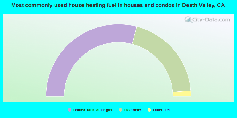
- 58.1%Bottled, tank, or LP gas
- 39.4%Electricity
- 2.5%Other fuel
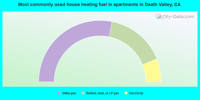
- 56.3%Utility gas
- 31.5%Bottled, tank, or LP gas
- 12.2%Electricity
Death Valley compared to California state average:
- Median house value significantly below state average.
- Unemployed percentage below state average.
- Black race population percentage significantly below state average.
- Hispanic race population percentage significantly below state average.
- Median age significantly above state average.
- Foreign-born population percentage significantly below state average.
- Length of stay since moving in significantly above state average.
- Number of rooms per house significantly below state average.
- House age significantly below state average.
- Number of college students below state average.
Death Valley on our top lists:
- #7 on the list of "Top 100 cities with largest land areas"
- #79 (92384) on the list of "Top 101 zip codes with the largest percentage of Danish first ancestries"