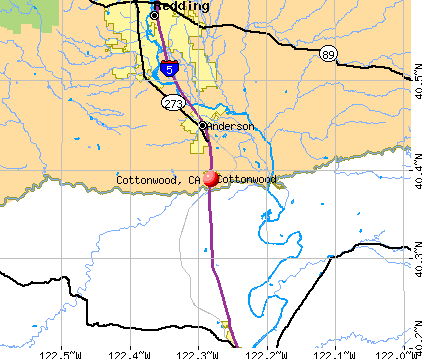
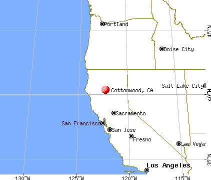
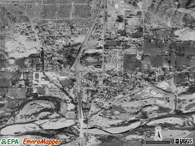
Cottonwood, California
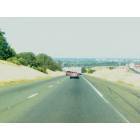
Cottonwood: Highway 5 South Cottonwood
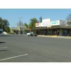
Cottonwood: Downtown Cottonwood
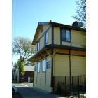
Cottonwood: old Tran Depot
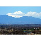
Cottonwood: Mt Shasta, North over Cottonwood, Sacramento River on bottom right.
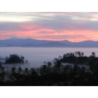
Cottonwood: Lassen Peak and southern Cascades behind foggy Sacramento Valleyat sunrise

Cottonwood: Lassen Peak and Fog over Sacramento River Valley-November 2011
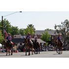
Cottonwood: Annual Cottonwood Mother's Day Parade on Front Street
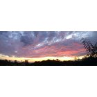
Cottonwood: a beautiful cottonwood sunset
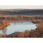
Cottonwood: Riverview Lake CA
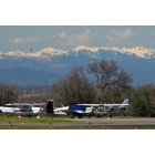
Cottonwood: Cottonwood,(Lake California), Ca. Airport. Trinity Alps in Background.
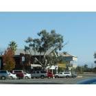
Cottonwood: Downtown Cottonwood
- add
your
Submit your own pictures of this place and show them to the world
- OSM Map
- General Map
- Google Map
- MSN Map
Population change since 2000: +12.0%
| Males: 1,610 | |
| Females: 1,706 |
| Median resident age: | 40.8 years |
| California median age: | 37.9 years |
Zip codes: 96022.
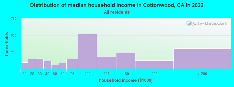
| Cottonwood: | $90,137 |
| CA: | $91,551 |
Estimated per capita income in 2022: $44,762 (it was $11,778 in 2000)
Cottonwood CDP income, earnings, and wages data
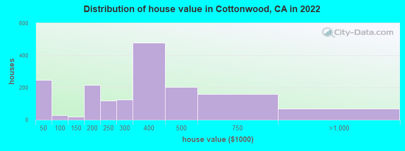
Estimated median house or condo value in 2022: $310,753 (it was $93,800 in 2000)
| Cottonwood: | $310,753 |
| CA: | $715,900 |
Mean prices in 2022: all housing units: $235,425; detached houses: $272,136; mobile homes: $65,110
Median gross rent in 2022: $1,165.
(8.2% for White Non-Hispanic residents, 12.0% for Hispanic or Latino residents, 27.4% for other race residents, 8.2% for two or more races residents)
Detailed information about poverty and poor residents in Cottonwood, CA


Compare current foreclosures near Cottonwood, CA:
| Photo | Address | Area | Beds / Baths | Price | Details |
|---|---|---|---|---|---|

|
#1
Hooker Creek Rd
Cottonwood, CA 96022
|
1,782 sq. feet
|
2 baths 3 beds |
show details | |

|
#2
Hooker Creek Rd
Cottonwood, CA 96022
|
2,565 sq. feet
|
2 baths 3 beds |
show details | |

|
#3
Bowman Rd
Cottonwood, CA 96022
|
1,500 sq. feet
|
2 baths 3 beds |
show details | |

|
#4
Mccann Rd
Cottonwood, CA 96022
|
1,482 sq. feet
|
2 baths 3 beds |
show details | |

|
#5
Bowman Rd
Cottonwood, CA 96022
|
1,943 sq. feet
|
1 baths 2 beds |
show details | |

|
#6
Benson Rd
Cottonwood, CA 96022
|
1,890 sq. feet
|
2 baths 4 beds |
show details | |

|
#7
Broadhurst Rd
Cottonwood, CA 96022
|
1,196 sq. feet
|
2 baths 3 beds |
show details | |

|
#8
Antler Way
Cottonwood, CA 96022
|
1,516 sq. feet
|
2 baths 3 beds |
show details | |

|
#9
Hidden Hills Rd
Cottonwood, CA 96022
|
- sq. feet
|
2 baths 3 beds |
show details | |

|
#10
Robinson Glen Dr
Cottonwood, CA 96022
|
- sq. feet
|
2 baths 3 beds |
show details |
| Photo | Address | Area | Beds / Baths | Price | Details |
|---|---|---|---|---|---|

|
#11
Mayfair Ct
Cottonwood, CA 96022
|
- sq. feet
|
1 baths 3 beds |
show details | |

|
#12
Oak Ln
Cottonwood, CA 96022
|
- sq. feet
|
2 baths 3 beds |
show details | |

|
#13
Brincat Manor Rd
Cottonwood, CA 96022
|
- sq. feet
|
- baths - beds |
show details | |

|
#14
Dickens Ln
Cottonwood, CA 96022
|
- sq. feet
|
- baths - beds |
show details | |

|
#15
Irwin Rd
Redding, CA 96002
|
1,135 sq. feet
|
2 baths 3 beds |
show details | |

|
#16
Leonard Dr
Redding, CA 96001
|
1,550 sq. feet
|
2 baths 3 beds |
show details | |

|
#17
Big Horn Dr
Redding, CA 96002
|
2,539 sq. feet
|
3 baths 4 beds |
show details | |

|
#18
Hartnell Ave
Redding, CA 96002
|
- sq. feet
|
1 baths 3 beds |
show details | |

|
#19
Regal Ave
Redding, CA 96002
|
1,305 sq. feet
|
1 baths 3 beds |
show details | |

|
#20
Jessica Way
Redding, CA 96002
|
1,142 sq. feet
|
2 baths 3 beds |
show details |
| Photo | Address | Area | Beds / Baths | Price | Details |
|---|---|---|---|---|---|

|
#21
Franzel Rd
Red Bluff, CA 96080
|
1,456 sq. feet
|
2 baths 3 beds |
show details | |

|
#22
Krueger Ct
Red Bluff, CA 96080
|
2,166 sq. feet
|
3 baths 5 beds |
show details | |

|
#23
Walton Ave
Red Bluff, CA 96080
|
- sq. feet
|
2 baths 4 beds |
show details | |

|
#24
Fayette Ln
Redding, CA 96003
|
1,440 sq. feet
|
2 baths 3 beds |
show details | |

|
#25
Chestnut Ave
Red Bluff, CA 96080
|
2,042 sq. feet
|
2 baths 3 beds |
show details | |

|
#26
Williams Ave
Red Bluff, CA 96080
|
1,591 sq. feet
|
2 baths 3 beds |
show details | |

|
#27
Lincoln St
Red Bluff, CA 96080
|
1,315 sq. feet
|
1 baths 2 beds |
show details | |

|
#28
Lloyd Ln
Anderson, CA 96007
|
800 sq. feet
|
1 baths 2 beds |
show details | |

|
#29
Hunting Club Rd
Palo Cedro, CA 96073
|
- sq. feet
|
3 baths 3 beds |
show details | |

|
#30
Jaxon Way
Redding, CA 96003
|
1,400 sq. feet
|
2 baths 3 beds |
show details |
| Photo | Address | Area | Beds / Baths | Price | Details |
|---|---|---|---|---|---|

|
#31
Sharon Ave
Anderson, CA 96007
|
1,162 sq. feet
|
2 baths 3 beds |
show details | |

|
#32
Newport Dr
Redding, CA 96001
|
- sq. feet
|
2 baths 3 beds |
show details | |

|
#33
Wernmark Dr
Red Bluff, CA 96080
|
1,100 sq. feet
|
1 baths 3 beds |
show details | |

|
#34
Hunt Ave
Red Bluff, CA 96080
|
1,474 sq. feet
|
2 baths 2 beds |
show details | |

|
#35
Evelyn St
Red Bluff, CA 96080
|
1,064 sq. feet
|
2 baths 3 beds |
show details | |

|
#36
Williams Ave
Red Bluff, CA 96080
|
1,591 sq. feet
|
2 baths 3 beds |
show details | |

|
#37
Reeds Creek Rd
Red Bluff, CA 96080
|
1,531 sq. feet
|
2 baths 3 beds |
show details | |

|
#38
Vallecito Way
Red Bluff, CA 96080
|
1,657 sq. feet
|
2 baths 3 beds |
show details | |

|
#39
Cuesta Verde Ct
Red Bluff, CA 96080
|
2,646 sq. feet
|
2 baths 3 beds |
show details | |

|
#40
Dwayne Ct
Redding, CA 96001
|
- sq. feet
|
2 baths 3 beds |
show details |
| Photo | Address | Area | Beds / Baths | Price | Details |
|---|---|---|---|---|---|

|
#41
Crosby Ln
Red Bluff, CA 96080
|
942 sq. feet
|
1 baths 2 beds |
show details | |

|
#42
Douglas St
Red Bluff, CA 96080
|
1,142 sq. feet
|
1 baths 3 beds |
show details | |

|
#43
Loren Ct
Anderson, CA 96007
|
- sq. feet
|
1 baths 2 beds |
show details | |

|
#44
Salmon Creek Rd
Redding, CA 96003
|
- sq. feet
|
2 baths 2 beds |
show details | |

|
#45
South St
Redding, CA 96001
|
- sq. feet
|
1 baths 2 beds |
show details | |

|
#46
Rocking Horse Ln
Redding, CA 96003
|
- sq. feet
|
4 baths 6 beds |
show details | |

|
#47
Hawthorne Ave
Redding, CA 96002
|
- sq. feet
|
2 baths 3 beds |
show details | |

|
#48
Franklin St
Anderson, CA 96007
|
- sq. feet
|
2 baths 3 beds |
show details | |

|
#49
Becky Way
Redding, CA 96002
|
- sq. feet
|
1 baths 3 beds |
show details | |

|
Check over 1 million property listings on Foreclosure.com!
|
browse all offers | |||


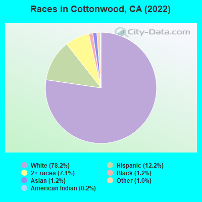
- 4,58578.2%White alone
- 71612.2%Hispanic
- 4157.1%Two or more races
- 731.2%Black alone
- 721.2%Asian alone
- 601.0%Other race alone
- 100.2%American Indian alone
According to our research of California and other state lists, there were 37 registered sex offenders living in Cottonwood, California as of May 09, 2024.
The ratio of all residents to sex offenders in Cottonwood is 99 to 1.
 Recent articles from our blog. Our writers, many of them Ph.D. graduates or candidates, create easy-to-read articles on a wide variety of topics.

 | Places you would considering living 'if' moving out-of-state (324 replies) |
| Demographics and changes in the outer East Bay (675 replies) |
| Moving from San Diego - lower COL options in CA? (44 replies) |
| Where should a young single professional (25-40) live? (51 replies) |
| Leaving Los Angeles: Where to move to? (157 replies) |
| Paradise Fire/Camp Creek Fire 11/08/2018 (783 replies) |
Latest news from Cottonwood, CA collected exclusively by city-data.com from local newspapers, TV, and radio stations
Ancestries: American (20.7%), Norwegian (9.8%), Italian (9.5%), German (8.2%), English (6.7%), Irish (4.2%).
Current Local Time: PST time zone
Elevation: 420 feet
Land area: 2.39 square miles.
Population density: 1,386 people per square mile (low).
141 residents are foreign born (1.6% Asia, 0.8% Latin America).
| This place: | 2.4% |
| California: | 26.5% |
Median real estate property taxes paid for housing units with mortgages in 2022: $2,624 (0.7%)
Median real estate property taxes paid for housing units with no mortgage in 2022: $1,028 (0.5%)
Nearest city with pop. 50,000+: Redding, CA  (13.8 miles , pop. 80,865).
Nearest city with pop. 200,000+: Sacramento, CA (134.0 miles , pop. 407,018).
Nearest city with pop. 1,000,000+: Los Angeles, CA (486.0 miles , pop. 3,694,820).
Nearest cities:
), ), ), )Latitude: 40.39 N, Longitude: 122.28 W
Area code: 530
| Here: | 5.6% |
| California: | 5.1% |
- Health care (14.1%)
- Accommodation & food services (8.5%)
- Educational services (7.3%)
- Construction (7.1%)
- Personal & laundry services (5.5%)
- Wood products (5.4%)
- Motor vehicle & parts dealers (4.4%)
- Construction (13.4%)
- Wood products (10.8%)
- Building material & garden equipment & supplies dealers (5.7%)
- Administrative & support & waste management services (5.7%)
- Motor vehicle & parts dealers (5.1%)
- Accommodation & food services (4.9%)
- Public administration (4.3%)
- Health care (27.2%)
- Accommodation & food services (12.1%)
- Educational services (11.6%)
- Personal & laundry services (9.7%)
- Finance & insurance (3.8%)
- Motor vehicle & parts dealers (3.7%)
- Social assistance (2.7%)
- Building and grounds cleaning and maintenance occupations (6.5%)
- Other sales and related occupations, including supervisors (6.2%)
- Driver/sales workers and truck drivers (5.7%)
- Supervisors and other personal care and service workers, except child care workers (4.5%)
- Other production occupations, including supervisors (4.5%)
- Construction traders workers except carpenters, electricians, painters, plumbers, and construction laborers (4.3%)
- Nursing, psychiatric, and home health aides (4.2%)
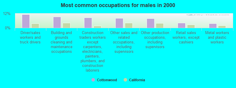
- Driver/sales workers and truck drivers (11.3%)
- Building and grounds cleaning and maintenance occupations (9.4%)
- Construction traders workers except carpenters, electricians, painters, plumbers, and construction laborers (8.6%)
- Other sales and related occupations, including supervisors (8.1%)
- Other production occupations, including supervisors (7.8%)
- Retail sales workers, except cashiers (4.1%)
- Metal workers and plastic workers (3.7%)
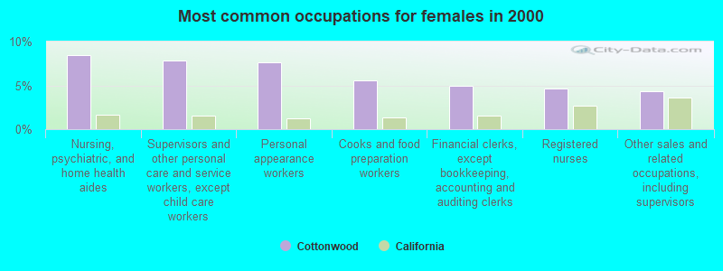
- Nursing, psychiatric, and home health aides (8.4%)
- Supervisors and other personal care and service workers, except child care workers (7.8%)
- Personal appearance workers (7.6%)
- Cooks and food preparation workers (5.6%)
- Financial clerks, except bookkeeping, accounting and auditing clerks (4.9%)
- Registered nurses (4.6%)
- Other sales and related occupations, including supervisors (4.3%)
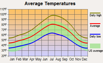
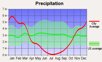
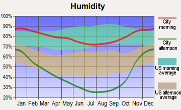
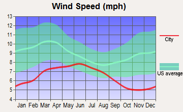
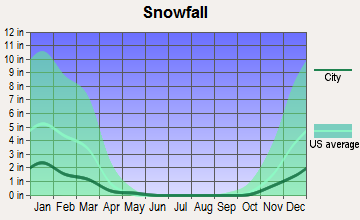
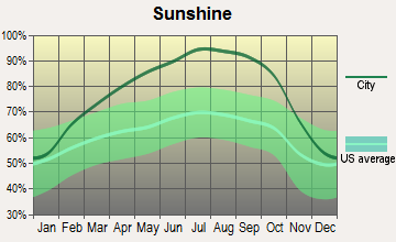
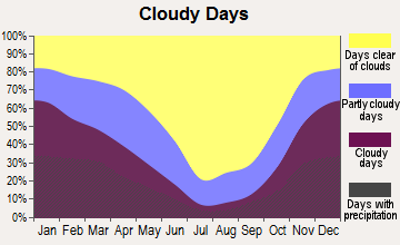
Average climate in Cottonwood, California
Based on data reported by over 4,000 weather stations
|
|

(lower is better)
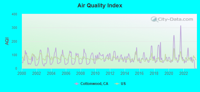
Air Quality Index (AQI) level in 2022 was 74.6. This is about average.
| City: | 74.6 |
| U.S.: | 72.6 |
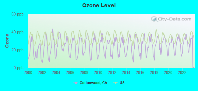
Ozone [ppb] level in 2022 was 27.8. This is about average. Closest monitor was 4.4 miles away from the city center.
| City: | 27.8 |
| U.S.: | 33.3 |
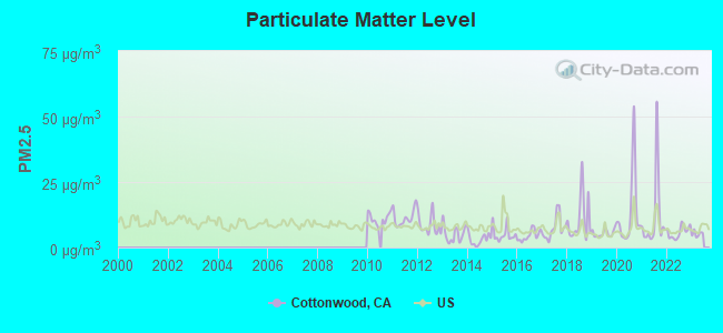
Particulate Matter (PM2.5) [µg/m3] level in 2022 was 5.82. This is better than average. Closest monitor was 12.3 miles away from the city center.
| City: | 5.82 |
| U.S.: | 8.11 |
Earthquake activity:
Cottonwood-area historical earthquake activity is significantly above California state average. It is 5395% greater than the overall U.S. average.On 4/18/1906 at 13:12:21, a magnitude 7.9 (7.9 UK, Class: Major, Intensity: VIII - XII) earthquake occurred 169.7 miles away from Cottonwood center, causing $524,000,000 total damage
On 1/31/1922 at 13:17:28, a magnitude 7.6 (7.6 UK) earthquake occurred 173.3 miles away from Cottonwood center
On 4/25/1992 at 18:06:04, a magnitude 7.2 (6.3 MB, 7.1 MS, 7.2 MW, 7.1 MW, Depth: 9.4 mi) earthquake occurred 94.2 miles away from the city center, causing $75,000,000 total damage
On 11/8/1980 at 10:27:34, a magnitude 7.2 (6.2 MB, 7.2 MS, 7.2 MW, 7.0 ML) earthquake occurred 116.9 miles away from Cottonwood center
On 10/3/1915 at 06:52:48, a magnitude 7.6 (7.6 UK) earthquake occurred 251.8 miles away from Cottonwood center
On 1/22/1923 at 09:04:18, a magnitude 7.2 (7.2 UK) earthquake occurred 160.3 miles away from Cottonwood center
Magnitude types: body-wave magnitude (MB), local magnitude (ML), surface-wave magnitude (MS), moment magnitude (MW)
Natural disasters:
The number of natural disasters in Shasta County (29) is a lot greater than the US average (15).Major Disasters (Presidential) Declared: 13
Emergencies Declared: 4
Causes of natural disasters: Floods: 14, Fires: 12, Storms: 8, Winter Storms: 6, Landslides: 5, Mudslides: 4, Drought: 1, Heavy Rain: 1, Hurricane: 1, Tornado: 1, Wind: 1, Other: 1 (Note: some incidents may be assigned to more than one category).
Hospitals and medical centers near Cottonwood:
- OAK RIVER REHAB (Nursing Home, about 5 miles away; ANDERSON, CA)
- HOSPITALITY CARE CENTER (Nursing Home, about 7 miles away; ANDERSON, CA)
- OSTERMAN'S FACILITY #2, INC (Hospital, about 12 miles away; REDDING, CA)
- CIRRUS HOUSE (Hospital, about 12 miles away; REDDING, CA)
- CANTERBURY HOUSE (Hospital, about 12 miles away; REDDING, CA)
- NVDS, INC - HARPOLE HOUSE (Hospital, about 12 miles away; REDDING, CA)
- MARQUIS CARE AT SHASTA (Nursing Home, about 13 miles away; REDDING, CA)
Airports located in Cottonwood:
- Flying N Ranch Airport (CA04) (Runways: 1)
- Lake California Air Park Airport (68CA) (Runways: 1)
Amtrak stations near Cottonwood:
- 15 miles: RED BLUFF (460 ANTELOPE BLVD.) - Bus Station . Services: fully wheelchair accessible, public payphones, free short-term parking, call for taxi service.
- 15 miles: REDDING (1620 YUBA ST.) . Services: fully wheelchair accessible, public payphones, free short-term parking, call for taxi service.
Colleges/universities with over 2000 students nearest to Cottonwood:
- Shasta College (about 17 miles; Redding, CA; Full-time enrollment: 5,645)
- California State University-Chico (about 52 miles; Chico, CA; FT enrollment: 14,838)
- Butte College (about 62 miles; Oroville, CA; FT enrollment: 8,649)
- Yuba College (about 96 miles; Marysville, CA; FT enrollment: 4,737)
- Mendocino College (about 97 miles; Ukiah, CA; FT enrollment: 2,263)
- Humboldt State University (about 101 miles; Arcata, CA; FT enrollment: 7,353)
- College of the Redwoods (about 103 miles; Eureka, CA; FT enrollment: 4,410)
Public high schools in Cottonwood:
- WEST VALLEY HIGH (Students: 639, Location: 3805 HAPPY VALLEY RD., Grades: 9-12)
- NORTHERN SUMMIT ACADEMY (Location: 3435 MAIN ST., STE. C, Grades: KG-12, Charter school)
Public elementary/middle schools in Cottonwood:
- EVERGREEN MIDDLE (Students: 429, Location: 19500 LRNG WAY, Grades: 5-8)
- WEST COTTONWOOD JUNIOR HIGH (Students: 332, Location: 20512 W. FIRST ST., Grades: 5-8)
- NORTH COTTONWOOD (Students: 322, Location: 19920 GAS POINT RD., Grades: KG-4)
- EVERGREEN ELEMENTARY (Students: 270, Location: 19415 HOOKER CREEK RD., Grades: KG-4)
- EVERGREEN COMMUNITY DAY (5-8) (Students: 9, Location: 19500 LRNG WAY, Grades: 5-8)
- EVERGREEN COMMUNITY DAY K-5 (Students: 6, Location: 19500 LRNG WAY, Grades: KG-5)
- COTTONWOOD CREEK CHARTER (Location: 3425 BRUSH ST., Grades: KG-8, Charter school)
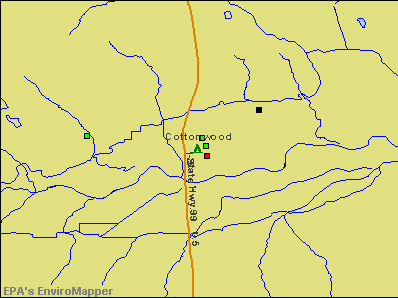
Points of interest:
Notable location: Cottonwood Fire Protection District (A). Display/hide its location on the map
Cemetery: Cottonwood Cemetery (1). Display/hide its location on the map
Park in Cottonwood: Cottonwood Historic District (1). Display/hide its location on the map
Tourist attraction: American Coaching Institute (Cultural Attractions- Events- & Facilities; 18925 Eleanor Lane).
Hotel: Alamo Motel & RV Park (3818 Main Street).
Birthplace of: Tom Hubert - Nextel Cup series NASCAR driver (born: Aug 6, 1964).
Drinking water stations with addresses in Cottonwood and their reported violations in the past:
ANDERSON PARK VILLAGE (Population served: 110, Groundwater):Past health violations:LAKE CALIFORNIA POA R.V. PARK (Population served: 70, Groundwater):Past monitoring violations:
- MCL, Monthly (TCR) - In AUG-2010, Contaminant: Coliform. Follow-up actions: St Public Notif issued (AUG-10-2010), St Compliance achieved (AUG-18-2010)
- MCL, Monthly (TCR) - In AUG-2009, Contaminant: Coliform. Follow-up actions: St Public Notif issued (AUG-12-2008), St Compliance achieved (SEP-02-2009), St Public Notif received (SEP-08-2009)
- MCL, Monthly (TCR) - In AUG-2009, Contaminant: Coliform. Follow-up actions: St Public Notif issued (AUG-12-2008), St Compliance achieved (SEP-02-2009), St Public Notif received (SEP-08-2009)
- MCL, Monthly (TCR) - In SEP-2008, Contaminant: Coliform. Follow-up actions: St Compliance achieved (SEP-11-2008), St Public Notif issued (SEP-16-2008), St Public Notif received (OCT-07-2008)
- MCL, Monthly (TCR) - In SEP-2008, Contaminant: Coliform. Follow-up actions: St Compliance achieved (SEP-11-2008), St Public Notif issued (SEP-16-2008), St Public Notif received (OCT-07-2008)
- MCL, Monthly (TCR) - In JUN-2008, Contaminant: Coliform. Follow-up actions: St Violation/Reminder Notice (JUN-16-2008), St Compliance achieved (JUN-26-2008), St Public Notif received (JUL-16-2008)
- MCL, Monthly (TCR) - In JUN-2008, Contaminant: Coliform. Follow-up actions: St Violation/Reminder Notice (JUN-16-2008), St Compliance achieved (JUN-26-2008), St Public Notif received (JUL-16-2008)
- Initial Tap Sampling for Pb and Cu - In JAN-01-1996, Contaminant: Lead and Copper Rule. Follow-up actions: St Violation/Reminder Notice (4 times from JAN-15-2003 to APR-01-2006), St Compliance achieved (MAY-26-2006)
- Initial Tap Sampling for Pb and Cu - In JUL-01-1993, Contaminant: Lead and Copper Rule. Follow-up actions: Fed Compliance achieved (FEB-28-2006)
- 2 routine major monitoring violations
Past monitoring violations:
- One regular monitoring violation
Drinking water stations with addresses in Cottonwood that have no violations reported:
- GOTT COUNTRY STORE (Population served: 25, Primary Water Source Type: Groundwater)
| This place: | 2.8 people |
| California: | 2.9 people |
| This place: | 74.4% |
| Whole state: | 68.7% |
| This place: | 9.7% |
| Whole state: | 7.2% |
Likely homosexual households (counted as self-reported same-sex unmarried-partner households)
- Lesbian couples: 0.3% of all households
- Gay men: 0.2% of all households
Banks with branches in Cottonwood (2011 data):
- Tri Counties Bank: Cottonwood Branch at 3349 Main Street, branch established on 1970/08/10. Info updated 2011/09/26: Bank assets: $2,554.4 mil, Deposits: $2,191.2 mil, headquarters in Chico, CA, positive income, Commercial Lending Specialization, 71 total offices, Holding Company: Trico Bancshares
- North Valley Bank: Cottonwood Branch at 20635 Gas Point Road, branch established on 1998/01/20. Info updated 2006/08/03: Bank assets: $900.5 mil, Deposits: $767.5 mil, headquarters in Redding, CA, positive income, Commercial Lending Specialization, 26 total offices, Holding Company: North Valley Bancorp
For population 15 years and over in Cottonwood:
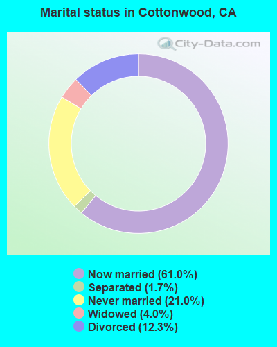
- Never married: 21.0%
- Now married: 61.0%
- Separated: 1.7%
- Widowed: 4.0%
- Divorced: 12.3%
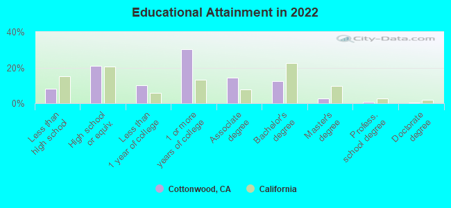
For population 25 years and over in Cottonwood:
- High school or higher: 91.1%
- Bachelor's degree or higher: 15.6%
- Graduate or professional degree: 3.9%
- Unemployed: 10.2%
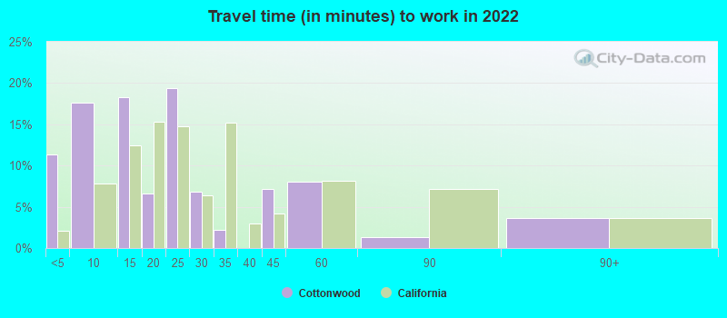
- Mean travel time to work (commute): 14.5 minutes
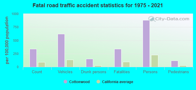
| Here: | 9.1 |
| California average: | 15.5 |
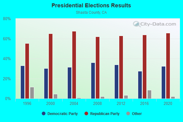
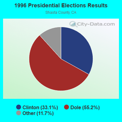
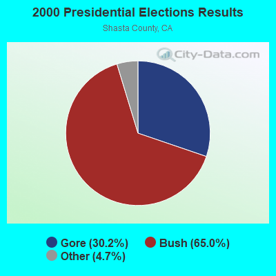
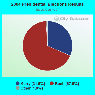
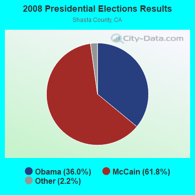
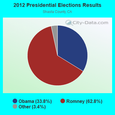
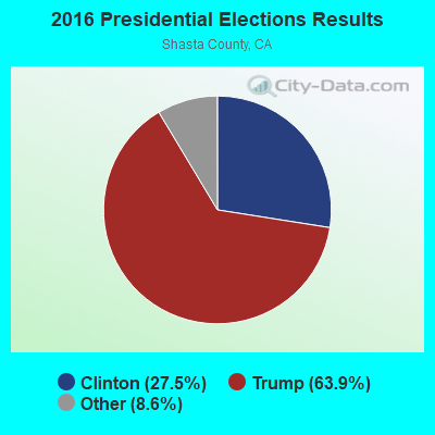

Graphs represent county-level data. Detailed 2008 Election Results
Religion statistics for Cottonwood, CA (based on Shasta County data)
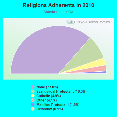
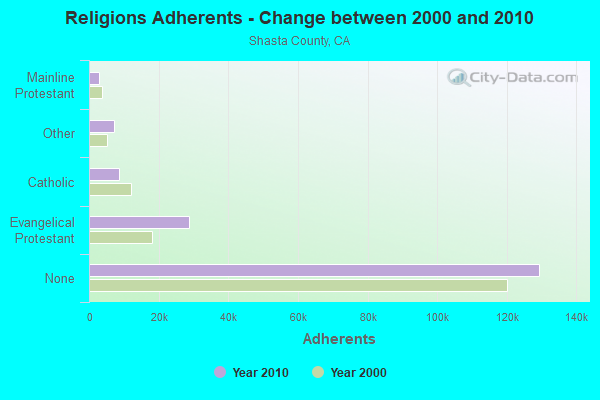
| Religion | Adherents | Congregations |
|---|---|---|
| Evangelical Protestant | 28,805 | 109 |
| Catholic | 8,629 | 8 |
| Other | 7,277 | 29 |
| Mainline Protestant | 2,830 | 12 |
| Orthodox | 191 | 5 |
| Black Protestant | 120 | 1 |
| None | 129,371 | - |
Food Environment Statistics:
| Shasta County: | 2.35 / 10,000 pop. |
| State: | 2.14 / 10,000 pop. |
| Here: | 0.06 / 10,000 pop. |
| California: | 0.04 / 10,000 pop. |
| This county: | 0.39 / 10,000 pop. |
| California: | 0.62 / 10,000 pop. |
| Shasta County: | 3.85 / 10,000 pop. |
| California: | 1.49 / 10,000 pop. |
| Here: | 6.42 / 10,000 pop. |
| State: | 7.42 / 10,000 pop. |
| Here: | 8.0% |
| California: | 7.3% |
| Shasta County: | 25.3% |
| California: | 21.3% |
| Shasta County: | 15.4% |
| California: | 17.9% |
Health and Nutrition:
| Cottonwood: | 49.5% |
| State: | 49.4% |
| This city: | 47.9% |
| California: | 48.0% |
| Cottonwood: | 29.1 |
| California: | 28.1 |
| This city: | 20.1% |
| California: | 20.2% |
| Cottonwood: | 9.3% |
| California: | 11.2% |
| This city: | 6.8 |
| California: | 6.8 |
| Here: | 36.7% |
| California: | 31.5% |
| Here: | 57.2% |
| State: | 56.4% |
| This city: | 79.3% |
| California: | 80.9% |
More about Health and Nutrition of Cottonwood, CA Residents
| Businesses in Cottonwood, CA | ||||
| Name | Count | Name | Count | |
|---|---|---|---|---|
| Ace Hardware | 1 | U-Haul | 1 | |
| Jones New York | 1 | UPS | 1 | |
Strongest AM radio stations in Cottonwood:
- KNRO (1670 AM; 10 kW; REDDING, CA; Owner: REGENT LICENSEE OF REDDING, INC.)
- KVIP (540 AM; 2 kW; REDDING, CA; Owner: PACIFIC CASCADE COMMUNICATIONS CORP.)
- KLXR (1230 AM; 1 kW; REDDING, CA; Owner: MICHAEL R. QUINN)
- KQMS (1400 AM; 1 kW; REDDING, CA; Owner: REGENT LICENSEE OF REDDING, INC)
- KBLF (1490 AM; 1 kW; RED BLUFF, CA; Owner: TOM HUTH)
- KKOH (780 AM; 50 kW; RENO, NV; Owner: CITADEL BROADCASTING COMPANY)
- KCBS (740 AM; 50 kW; SAN FRANCISCO, CA; Owner: INFINITY BROADCASTING OPERATIONS, INC.)
- KFBK (1530 AM; 50 kW; SACRAMENTO, CA; Owner: AMFM RADIO LICENSES, L.L.C.)
- KFIA (710 AM; 25 kW; CARMICHAEL, CA; Owner: VISTA BROADCASTING INC.)
- KHTK (1140 AM; 50 kW; SACRAMENTO, CA; Owner: INFINITY RADIO SUBSIDIARY OPERATIONS INC.)
- KNBR (680 AM; 50 kW; SAN FRANCISCO, CA; Owner: KNBR LICO, INC.)
- KTRB (860 AM; 50 kW; MODESTO, CA; Owner: PAPPAS RADIO OF CALIFORNIA, A CALIFORNIA LIMITED PARTNERSHIP)
- KSTE (650 AM; 25 kW; RANCHO CORDOVA, CA; Owner: AMFM RADIO LICENSES, L.L.C.)
Strongest FM radio stations in Cottonwood:
- KHRD (103.1 FM; WEAVERVILLE, CA; Owner: RESULTS RADIO LICENSEE, LLC)
- KNCQ (97.3 FM; REDDING, CA; Owner: RESULTS RADIO OF REDDING, LLC)
- KNNN (99.3 FM; SHASTA LAKE CITY, CA; Owner: REGENT LICENSEE OF REDDING, INC.)
- K225AJ (92.9 FM; BURNEY/REDDING, CA; Owner: CALVARY CHAPEL OF TWIN FALLS, INC.)
- KRDG (105.3 FM; SHINGLETOWN, CA; Owner: REGENT LICENSEE OF REDDING, INC.)
- KLVB-FM (102.7 FM; RED BLUFF, CA; Owner: EDUCATIONAL MEDIA FOUNDATION)
- KVIP-FM (98.1 FM; REDDING, CA; Owner: PACIFIC CASCADE COMMUNICATIONS CORP.)
- KEWB (94.7 FM; ANDERSON, CA; Owner: RESULTS RADIO OF REDDING, LLC)
- KSHA (104.3 FM; REDDING, CA; Owner: REGENT LICENSEE OF REDDING, INC)
- K268AJ (101.5 FM; REDDING, CA; Owner: FAMILY STATIONS, INC.)
- K227AE (93.3 FM; REDDING, CA; Owner: RESULTS RADIO OF REDDING, LLC)
- KESR (107.1 FM; SHASTA LAKE CITY, CA; Owner: RESULTS RADIO OF REDDING, LLC)
- KKXS (96.1 FM; SHINGLETOWN, CA; Owner: RESULTS RADIO LICENSEE, LLC)
- KWCA (101.1 FM; WEAVERVILLE, CA; Owner: GEORGE S. FLINN, JR.)
- KNCA (89.7 FM; BURNEY, CA; Owner: OREGON STATE BOARD OF HIGHER ED.)
- KTHU (100.7 FM; CORNING, CA; Owner: RESULTS RADIO LICENSEE, LLC)
- KRRX (106.1 FM; BURNEY, CA; Owner: REGENT LICENSEE OF REDDING, INC.)
- K205EJ (88.9 FM; CHESTER, CA; Owner: CALVARY CHAPEL OF TWIN FALLS, INC.)
- K220EB (91.9 FM; BURNEY, CA; Owner: THE UNIVERSITY FOUNDATION)
- KALF (95.7 FM; RED BLUFF, CA; Owner: REGENT LICENSEE OF CHICO, INC)
TV broadcast stations around Cottonwood:
- KNVN (Channel 24; CHICO, CA; Owner: CHICO LICENSE, L.L.C.)
- K50GP (Channel 50; REDDING, CA; Owner: TRINITY BROADCASTING NETWORK)
- National Bridge Inventory (NBI) Statistics
- 29Number of bridges
- 482ft / 147mTotal length
- 330,853Total average daily traffic
- 48,267Total average daily truck traffic
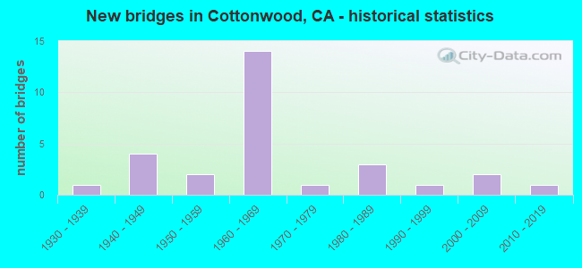
- New bridges - historical statistics
- 11930-1939
- 41940-1949
- 21950-1959
- 141960-1969
- 11970-1979
- 31980-1989
- 11990-1999
- 22000-2009
- 12010-2019
FCC Registered Antenna Towers: 17 (See the full list of FCC Registered Antenna Towers)
FCC Registered Private Land Mobile Towers: 1 (See the full list of FCC Registered Private Land Mobile Towers in Cottonwood, CA)
FCC Registered Broadcast Land Mobile Towers: 10 (See the full list of FCC Registered Broadcast Land Mobile Towers)
FCC Registered Microwave Towers: 14 (See the full list of FCC Registered Microwave Towers in this town)
FCC Registered Amateur Radio Licenses: 102 (See the full list of FCC Registered Amateur Radio Licenses in Cottonwood)
FAA Registered Aircraft Manufacturers and Dealers: 1 (See the full list of FAA Registered Manufacturers and Dealers in Cottonwood)
FAA Registered Aircraft: 47 (See the full list of FAA Registered Aircraft)
2005 - 2018 National Fire Incident Reporting System (NFIRS) incidents
- Fire incident types reported to NFIRS in Cottonwood, CA
- 43354.3%Outside Fires
- 19524.5%Structure Fires
- 9912.4%Mobile Property/Vehicle Fires
- 708.8%Other
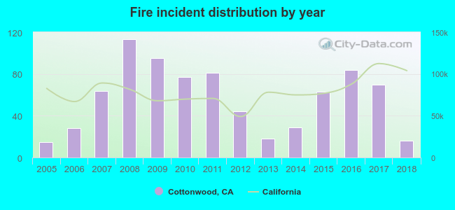 Based on the data from the years 2005 - 2018 the average number of fires per year is 57. The highest number of reported fire incidents - 113 took place in 2008, and the least - 15 in 2005. The data has a rising trend.
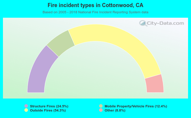 When looking into fire subcategories, the most incidents belonged to: Outside Fires (54.3%), and Structure Fires (24.5%).
| Most common first names in Cottonwood, CA among deceased individuals | ||
| Name | Count | Lived (average) |
|---|---|---|
| Robert | 69 | 74.5 years |
| John | 68 | 71.7 years |
| William | 68 | 73.5 years |
| James | 61 | 73.0 years |
| Mary | 48 | 81.5 years |
| George | 39 | 76.4 years |
| Charles | 36 | 72.3 years |
| Richard | 32 | 70.2 years |
| Helen | 27 | 78.7 years |
| Joseph | 26 | 73.2 years |
| Most common last names in Cottonwood, CA among deceased individuals | ||
| Last name | Count | Lived (average) |
|---|---|---|
| Smith | 28 | 76.4 years |
| Johnson | 23 | 73.6 years |
| Davis | 20 | 71.5 years |
| Williams | 19 | 76.4 years |
| Jones | 17 | 75.9 years |
| Moore | 15 | 79.0 years |
| Miller | 14 | 75.4 years |
| Taylor | 14 | 74.5 years |
| Brown | 13 | 76.5 years |
| Morgan | 13 | 75.1 years |
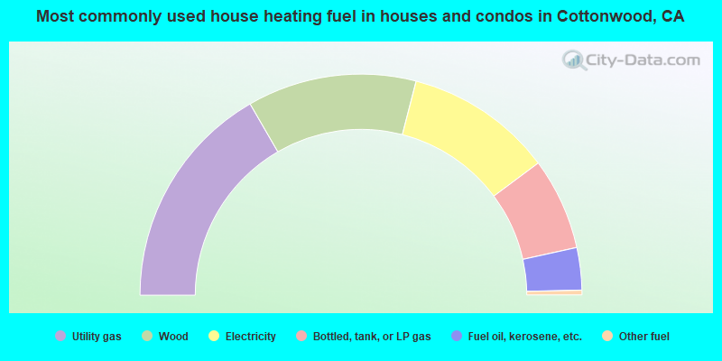
- 33.3%Utility gas
- 24.8%Wood
- 21.6%Electricity
- 13.5%Bottled, tank, or LP gas
- 6.2%Fuel oil, kerosene, etc.
- 0.7%Other fuel
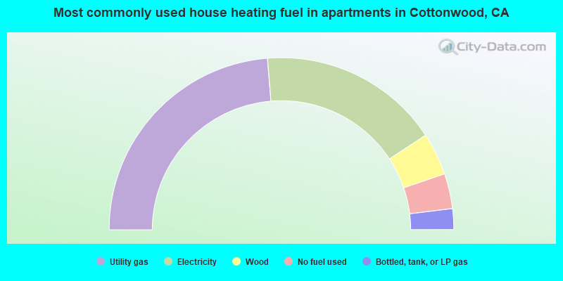
- 47.4%Utility gas
- 34.1%Electricity
- 8.0%Wood
- 6.6%No fuel used
- 3.9%Bottled, tank, or LP gas
Cottonwood compared to California state average:
- Median house value significantly below state average.
- Black race population percentage below state average.
- Foreign-born population percentage significantly below state average.
- Length of stay since moving in significantly above state average.
- Percentage of population with a bachelor's degree or higher below state average.
State forum archive:
- California Pages: 2 3 4 5 6 7 8 9 10 11 12 13 14 15 16 17 18 19 20 21 22 23 24 25 26 27 28 29 30 31 32 33 34 35 36 37 38 39 40 41 42 43 44 45 46 47 48 49 50 51 52 53 54 55 56 57 58 59 60 61 62 63 64 65 66 67 68 69 70 71 72 73 74 75 76 77 78 79
- Los Angeles Pages: 2 3 4 5 6 7 8 9 10 11 12 13 14 15 16 17 18 19 20 21 22 23 24 25 26 27 28 29 30 31 32 33 34 35 36 37 38 39 40 41 42 43 44 45 46 47 48 49 50 51 52 53 54 55 56 57 58 59 60 61 62 63 64 65 66 67 68 69 70 71 72 73 74 75 76 77 78 79 80 81 82 83 84 85 86 87 88 89 90 91 92 93 94 95 96 97 98 99 100 101 102 103 104 105 106 107 108 109 110 111 112 113 114 115 116 117 118 119 120 121 122 123
- Monterey County Pages: 2 3
- Orange County Pages: 2 3 4 5 6 7 8 9 10 11 12 13 14 15 16 17 18 19 20 21 22 23 24 25 26 27 28 29 30 31 32 33 34 35 36
- Sacramento Pages: 2 3 4 5 6 7 8 9 10 11 12 13 14 15 16 17 18 19 20 21 22 23 24 25 26 27 28 29 30 31 32
- San Bernardino and Riverside Counties Pages: 2 3 4 5 6 7 8 9 10 11 12 13 14 15 16 17 18 19 20 21 22 23
- San Diego Pages: 2 3 4 5 6 7 8 9 10 11 12 13 14 15 16 17 18 19 20 21 22 23 24 25 26 27 28 29 30 31 32 33 34 35 36 37 38 39 40 41 42 43 44 45 46 47 48 49 50 51 52 53 54 55 56 57 58 59 60 61 62 63 64 65 66 67 68 69 70 71 72 73 74 75 76
- San Francisco - Oakland Pages: 2 3 4 5 6 7 8 9 10 11 12 13 14 15 16 17 18 19 20 21 22 23 24 25 26 27 28 29 30 31 32 33 34 35 36 37 38 39 40 41 42 43 44 45 46 47 48 49 50 51 52 53 54 55 56 57 58 59 60 61 62 63 64 65 66 67 68 69 70 71 72
- San Jose Pages: 2 3 4 5 6 7 8 9 10 11 12 13 14 15 16 17 18 19 20 21 22 23 24
- Ventura County Pages: 2 3 4 5 6 7

|
|
Total of 6 patent applications in 2008-2024.