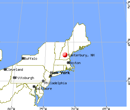
Canterbury, New Hampshire
Submit your own pictures of this town and show them to the world
- OSM Map
- General Map
- Google Map
- MSN Map

Population change since 2000: +18.8%
 |
| Males: 1,163 | |
| Females: 1,189 |
| Median resident age: | 46.9 years |
| New Hampshire median age: | 43.9 years |
Zip codes: 03224.
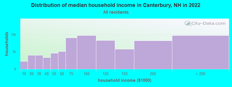
| Canterbury: | $101,278 |
| NH: | $89,992 |
Estimated per capita income in 2022: $54,833 (it was $27,374 in 2000)
Canterbury town income, earnings, and wages data
Estimated median house or condo value in 2022: $441,879 (it was $141,200 in 2000)
| Canterbury: | $441,879 |
| NH: | $384,700 |
Mean prices in 2022: all housing units: $378,901; detached houses: $416,256; townhouses or other attached units: $317,750; in 2-unit structures: $298,869; in 3-to-4-unit structures: $371,619; in 5-or-more-unit structures: $216,601; mobile homes: $110,180; occupied boats, rvs, vans, etc.: $74,347
Detailed information about poverty and poor residents in Canterbury, NH


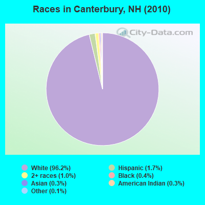
- 2,26296.2%White alone
- 391.7%Hispanic
- 231.0%Two or more races
- 100.4%Black alone
- 60.3%American Indian alone
- 70.3%Asian alone
- 30.1%Other race alone
- 20.09%Native Hawaiian and Other
Pacific Islander alone
Races in Canterbury detailed stats: ancestries, foreign born residents, place of birth
According to our research of New Hampshire and other state lists, there were 3 registered sex offenders living in Canterbury, New Hampshire as of May 17, 2024.
The ratio of all residents to sex offenders in Canterbury is 784 to 1.
The ratio of registered sex offenders to all residents in this city is lower than the state average.
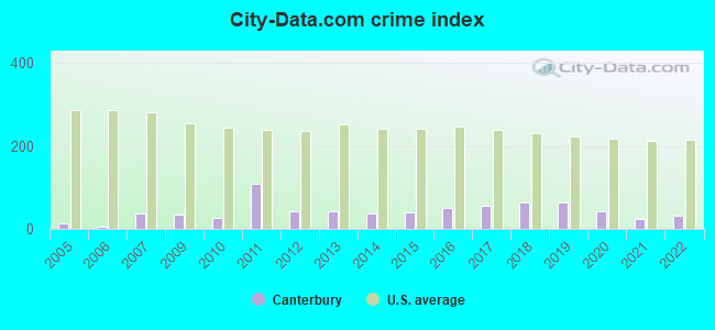
Type |
2009 |
2010 |
2011 |
2012 |
2013 |
2014 |
2015 |
2016 |
2017 |
2018 |
2019 |
2020 |
2021 |
2022 |
|---|---|---|---|---|---|---|---|---|---|---|---|---|---|---|
| Murders (per 100,000) | 0 (0.0) | 0 (0.0) | 0 (0.0) | 0 (0.0) | 0 (0.0) | 0 (0.0) | 0 (0.0) | 0 (0.0) | 0 (0.0) | 0 (0.0) | 0 (0.0) | 0 (0.0) | 0 (0.0) | 0 (0.0) |
| Rapes (per 100,000) | 0 (0.0) | 0 (0.0) | 0 (0.0) | 0 (0.0) | 0 (0.0) | 0 (0.0) | 0 (0.0) | 0 (0.0) | 0 (0.0) | 0 (0.0) | 0 (0.0) | 0 (0.0) | 0 (0.0) | 0 (0.0) |
| Robberies (per 100,000) | 0 (0.0) | 0 (0.0) | 0 (0.0) | 0 (0.0) | 0 (0.0) | 0 (0.0) | 0 (0.0) | 1 (41.6) | 0 (0.0) | 0 (0.0) | 0 (0.0) | 0 (0.0) | 0 (0.0) | 0 (0.0) |
| Assaults (per 100,000) | 0 (0.0) | 0 (0.0) | 0 (0.0) | 0 (0.0) | 1 (42.1) | 0 (0.0) | 0 (0.0) | 0 (0.0) | 0 (0.0) | 3 (123.3) | 2 (81.0) | 1 (40.4) | 0 (0.0) | 1 (40.3) |
| Burglaries (per 100,000) | 3 (128.5) | 3 (127.6) | 2 (84.9) | 2 (84.7) | 2 (84.2) | 0 (0.0) | 5 (209.3) | 5 (208.2) | 2 (82.8) | 1 (41.1) | 3 (121.6) | 2 (80.8) | 0 (0.0) | 1 (40.3) |
| Thefts (per 100,000) | 13 (557.0) | 8 (340.1) | 6 (254.8) | 19 (805.1) | 17 (716.1) | 22 (917.0) | 12 (502.3) | 14 (583.1) | 27 (1,118) | 17 (698.4) | 21 (850.9) | 16 (646.5) | 12 (478.1) | 11 (443.0) |
| Auto thefts (per 100,000) | 1 (42.8) | 1 (42.5) | 27 (1,146) | 1 (42.4) | 0 (0.0) | 0 (0.0) | 2 (83.7) | 0 (0.0) | 2 (82.8) | 3 (123.3) | 2 (81.0) | 1 (40.4) | 2 (79.7) | 1 (40.3) |
| Arson (per 100,000) | 0 (0.0) | 0 (0.0) | 0 (0.0) | 1 (42.4) | 0 (0.0) | 0 (0.0) | 0 (0.0) | 0 (0.0) | 0 (0.0) | 0 (0.0) | 2 (81.0) | 0 (0.0) | 1 (39.8) | 0 (0.0) |
| City-Data.com crime index | 34.7 | 25.9 | 107.9 | 41.5 | 43.0 | 36.7 | 41.4 | 50.4 | 57.1 | 65.3 | 65.2 | 42.8 | 25.5 | 31.8 |
The City-Data.com crime index weighs serious crimes and violent crimes more heavily. Higher means more crime, U.S. average is 246.1. It adjusts for the number of visitors and daily workers commuting into cities.
Crime rate in Canterbury detailed stats: murders, rapes, robberies, assaults, burglaries, thefts, arson
Full-time law enforcement employees in 2021, including police officers: 3 (3 officers - 2 male; 1 female).
| Officers per 1,000 residents here: | 1.20 |
| New Hampshire average: | 2.14 |
 Recent articles from our blog. Our writers, many of them Ph.D. graduates or candidates, create easy-to-read articles on a wide variety of topics.

 | Hollis, NH, to retire? is New Hampshire conservative (85 replies) |
| Canterbury?? (2 replies) |
| Plow Guy Suggestions - Canterbury/Gilmanton (4 replies) |
| Question on NH (18 replies) |
| First visit to NH (28 replies) |
| Thinking of moving to New Hampshire from WA (40 replies) |
Latest news from Canterbury, NH collected exclusively by city-data.com from local newspapers, TV, and radio stations
Ancestries: English (26.6%), Irish (15.6%), German (11.8%), French (10.2%), French Canadian (9.1%), Italian (7.8%).
Current Local Time: EST time zone
Incorporated in 1741
Elevation: 595 feet
Land area: 43.8 square miles.
Population density: 54 people per square mile (very low).
40 residents are foreign born (1.1% North America, 0.4% Europe, 0.4% Asia).
| This town: | 2.0% |
| New Hampshire: | 4.4% |
| Canterbury town: | 2.1% ($2,947) |
| New Hampshire: | 2.3% ($2,946) |
Nearest city with pop. 50,000+: Manchester, NH  (25.2 miles , pop. 107,006).
Nearest city with pop. 200,000+: Boston, MA (74.5 miles , pop. 589,141).
Nearest city with pop. 1,000,000+: Bronx, NY (209.7 miles , pop. 1,332,650).
Nearest cities:
), ), ), ), Latitude: 43.34 N, Longitude: 71.55 W
Area code: 603

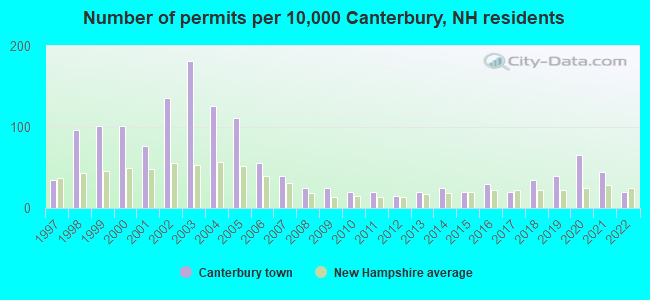
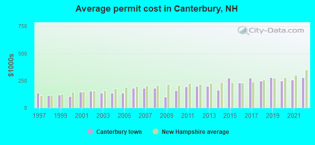
Single-family new house construction building permits:
- 2022: 4 buildings, average cost: $279,200
- 2021: 9 buildings, average cost: $259,200
- 2020: 13 buildings, average cost: $248,200
- 2019: 8 buildings, average cost: $282,200
- 2018: 7 buildings, average cost: $250,000
- 2017: 4 buildings, average cost: $276,800
- 2016: 6 buildings, average cost: $233,300
- 2015: 4 buildings, average cost: $275,000
- 2014: 5 buildings, average cost: $164,000
- 2013: 4 buildings, average cost: $200,000
- 2012: 3 buildings, average cost: $200,000
- 2011: 4 buildings, average cost: $196,000
- 2010: 4 buildings, average cost: $157,500
- 2009: 5 buildings, average cost: $103,800
- 2008: 5 buildings, average cost: $181,800
- 2007: 8 buildings, average cost: $181,800
- 2006: 11 buildings, average cost: $181,800
- 2005: 22 buildings, average cost: $138,800
- 2004: 25 buildings, average cost: $138,800
- 2003: 36 buildings, average cost: $137,400
- 2002: 27 buildings, average cost: $154,400
- 2001: 15 buildings, average cost: $147,700
- 2000: 20 buildings, average cost: $105,800
- 1999: 20 buildings, average cost: $120,200
- 1998: 19 buildings, average cost: $117,300
- 1997: 7 buildings, average cost: $137,700
| Here: | 2.0% |
| New Hampshire: | 2.5% |
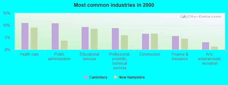
- Health care (11.1%)
- Public administration (10.9%)
- Educational services (9.4%)
- Professional, scientific, technical services (9.0%)
- Construction (6.6%)
- Finance & insurance (5.8%)
- Arts, entertainment, recreation (3.1%)
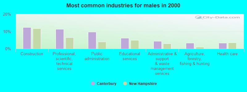
- Construction (12.3%)
- Professional, scientific, technical services (11.3%)
- Public administration (9.7%)
- Educational services (6.2%)
- Administrative & support & waste management services (4.4%)
- Agriculture, forestry, fishing & hunting (3.4%)
- Health care (3.4%)
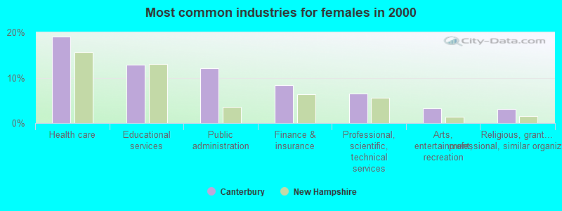
- Health care (19.0%)
- Educational services (12.8%)
- Public administration (12.1%)
- Finance & insurance (8.4%)
- Professional, scientific, technical services (6.6%)
- Arts, entertainment, recreation (3.2%)
- Religious, grantmaking, civic, professional, similar organizations (3.0%)
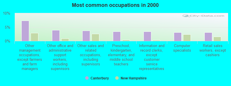
- Other management occupations, except farmers and farm managers (7.3%)
- Other office and administrative support workers, including supervisors (3.9%)
- Other sales and related occupations, including supervisors (3.7%)
- Preschool, kindergarten, elementary, and middle school teachers (3.4%)
- Information and record clerks, except customer service representatives (3.4%)
- Computer specialists (3.1%)
- Retail sales workers, except cashiers (3.1%)
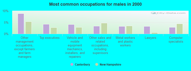
- Other management occupations, except farmers and farm managers (8.9%)
- Top executives (4.3%)
- Vehicle and mobile equipment mechanics, installers, and repairers (4.1%)
- Other sales and related occupations, including supervisors (3.4%)
- Metal workers and plastic workers (3.2%)
- Lawyers (3.2%)
- Computer specialists (2.9%)
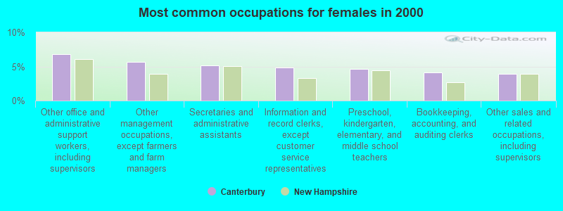
- Other office and administrative support workers, including supervisors (6.8%)
- Other management occupations, except farmers and farm managers (5.7%)
- Secretaries and administrative assistants (5.2%)
- Information and record clerks, except customer service representatives (4.8%)
- Preschool, kindergarten, elementary, and middle school teachers (4.6%)
- Bookkeeping, accounting, and auditing clerks (4.1%)
- Other sales and related occupations, including supervisors (3.9%)
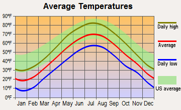
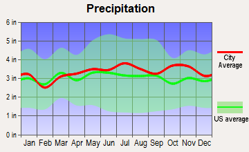
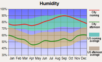
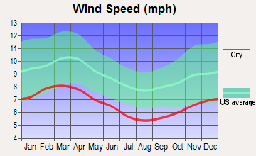
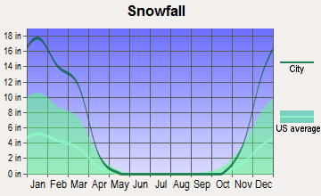
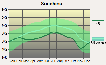
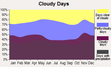
Average climate in Canterbury, New Hampshire
Based on data reported by over 4,000 weather stations
(lower is better)
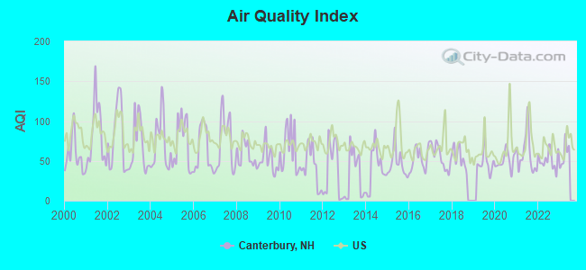
Air Quality Index (AQI) level in 2022 was 51.1. This is significantly better than average.
| City: | 51.1 |
| U.S.: | 72.6 |

Nitrogen Dioxide (NO2) [ppb] level in 2010 was 8.02. This is significantly worse than average. Closest monitor was 9.9 miles away from the city center.
| City: | 8.02 |
| U.S.: | 5.11 |
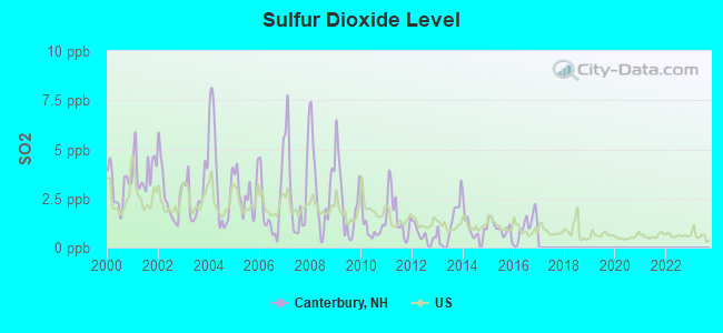
Sulfur Dioxide (SO2) [ppb] level in 2016 was 1.05. This is significantly better than average. Closest monitor was 8.8 miles away from the city center.
| City: | 1.05 |
| U.S.: | 1.51 |
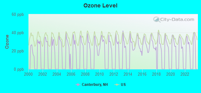
Ozone [ppb] level in 2022 was 29.4. This is about average. Closest monitor was 8.8 miles away from the city center.
| City: | 29.4 |
| U.S.: | 33.3 |
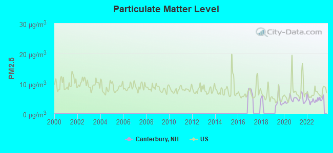
Particulate Matter (PM2.5) [µg/m3] level in 2022 was 4.52. This is significantly better than average. Closest monitor was 9.3 miles away from the city center.
| City: | 4.52 |
| U.S.: | 8.11 |
Tornado activity:
Canterbury-area historical tornado activity is near New Hampshire state average. It is 51% smaller than the overall U.S. average.
On 7/3/1972, a category F2 (max. wind speeds 113-157 mph) tornado 8.2 miles away from the Canterbury town center injured 7 people and caused between $5000 and $50,000 in damages.
On 6/9/1953, a category F3 (max. wind speeds 158-206 mph) tornado 39.1 miles away from the town center injured 5 people and caused between $5000 and $50,000 in damages.
Earthquake activity:
Canterbury-area historical earthquake activity is significantly above New Hampshire state average. It is 71% smaller than the overall U.S. average.On 4/20/2002 at 10:50:47, a magnitude 5.3 (5.3 ML, Depth: 3.0 mi, Class: Moderate, Intensity: VI - VII) earthquake occurred 134.0 miles away from the city center
On 1/19/1982 at 00:14:42, a magnitude 4.7 (4.5 MB, 4.7 MD, 4.5 LG, Class: Light, Intensity: IV - V) earthquake occurred 11.1 miles away from Canterbury center
On 10/7/1983 at 10:18:46, a magnitude 5.3 (5.1 MB, 5.3 LG, 5.1 ML) earthquake occurred 145.8 miles away from Canterbury center
On 4/20/2002 at 10:50:47, a magnitude 5.2 (5.2 MB, 4.2 MS, 5.2 MW, 5.0 MW) earthquake occurred 133.8 miles away from the city center
On 10/16/2012 at 23:12:25, a magnitude 4.7 (4.7 ML, Depth: 10.0 mi) earthquake occurred 48.4 miles away from Canterbury center
On 8/21/1996 at 07:54:14, a magnitude 3.8 (3.8 LG, 3.6 LG, Depth: 6.2 mi, Class: Light, Intensity: II - III) earthquake occurred 59.0 miles away from the city center
Magnitude types: regional Lg-wave magnitude (LG), body-wave magnitude (MB), duration magnitude (MD), local magnitude (ML), surface-wave magnitude (MS), moment magnitude (MW)
Natural disasters:
The number of natural disasters in Merrimack County (27) is a lot greater than the US average (15).Major Disasters (Presidential) Declared: 17
Emergencies Declared: 9
Causes of natural disasters: Storms: 13, Floods: 12, Winter Storms: 4, Snowstorms: 3, Hurricanes: 2, Snows: 2, Blizzard: 1, Ice Storm: 1, Snowfall: 1, Tornado: 1, Tropical Storm: 1, Wind: 1, Other: 1 (Note: some incidents may be assigned to more than one category).
Hospitals and medical centers near Canterbury:
- MERRIMACK COUNTY NURSING HOME (Nursing Home, about 5 miles away; BOSCAWEN, NH)
- MOUNTAIN RIDGE CENTER, GENESIS HEALTHCARE (Nursing Home, about 8 miles away; FRANKLIN, NH)
- MERRILL MANOR ANNEX (Nursing Home, about 9 miles away; FRANKLIN, NH)
- VNA OF FRANKLIN (Home Health Center, about 9 miles away; FRANKLIN, NH)
- FRANKLIN REGIONAL HOSPITAL Critical Access Hospitals (about 9 miles away; FRANKLIN, NH)
- MERRILL MANOR NURSING HOME (Nursing Home, about 9 miles away; FRANKLIN, NH)
- HAVENWOOD-HERITAGE HEIGHTS (Nursing Home, about 9 miles away; CONCORD, NH)
Colleges/universities with over 2000 students nearest to Canterbury:
- NHTI-Concord's Community College (about 9 miles; Concord, NH; Full-time enrollment: 2,865)
- Southern New Hampshire University (about 22 miles; Manchester, NH; FT enrollment: 16,552)
- Saint Anselm College (about 25 miles; Manchester, NH; FT enrollment: 2,059)
- Mount Washington College (about 27 miles; Manchester, NH; FT enrollment: 2,187)
- Plymouth State University (about 30 miles; Plymouth, NH; FT enrollment: 4,838)
- University of New Hampshire-Main Campus (about 35 miles; Durham, NH; FT enrollment: 15,243)
- Dartmouth College (about 45 miles; Hanover, NH; FT enrollment: 6,030)
Public elementary/middle school in Canterbury:
- CANTERBURY ELEMENTARY SCHOOL (Students: 138, Location: 15 BAPTIST RD., Grades: KG-5)
Private elementary/middle schools in Canterbury:
- BURNHAM BROOK SCHOOL (Students: 14, Location: 106 KIMBALL POND RD, Grades: 2-8)
- CANTERBURY CHILDREN'S CENTER (Students: 9, Location: 53 PICKARD RD, Grades: 1-3)
User-submitted facts and corrections:
- other colleges in the area: such as New England College in Henniker NH Colby-Sawyer College Keene State College Plymouth State College New Hampshire Tech In Concord NH
Points of interest:
Notable locations in Canterbury: Great Brook Farm (A), Hackleboro Orchards (B), Elkins Public Library (C), Canterbury Volunteer Fire Department (D). Display/hide their locations on the map
Cemeteries: Shaker Cemetery (1), Ham Cemetery (2), Zions Hill Cemetery (3), Shell Church Cemetery (4), Maple Grove Cemetery (5). Display/hide their locations on the map
Lakes, reservoirs, and swamps: Carding Mill Pond (A), Crane Neck Pond (B), Forest Pond (C), Horseshoe Pond (D), Kimball Pond (E), Morrill Pond (F), New Pond (G), Rocky Pond (H). Display/hide their locations on the map
Streams, rivers, and creeks: Hazleton Brook (A), Forest Pond Brook (B), Davis Brook (C), Cold Brook (D). Display/hide their locations on the map
Park in Canterbury: Hannah Dustin Historical Site (1). Display/hide its location on the map
Birthplace of: Kenneth MacKenna - Film actor.
Drinking water stations with addresses in Canterbury that have no violations reported:
- TOWN OFFICES/LIBRARY (Population served: 25, Primary Water Source Type: Groundwater)
| This town: | 2.6 people |
| New Hampshire: | 2.5 people |
| This town: | 75.8% |
| Whole state: | 66.3% |
| This town: | 8.7% |
| Whole state: | 8.3% |
Likely homosexual households (counted as self-reported same-sex unmarried-partner households)
- Lesbian couples: 1.2% of all households
- Gay men: 0.3% of all households
| This town: | 2.5% |
| Whole state: | 6.5% |
| This town: | 1.3% |
| Whole state: | 2.8% |
3 people in other noninstitutional group quarters in 2000
For population 15 years and over in Canterbury:
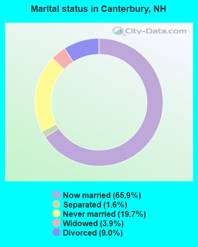
- Never married: 19.7%
- Now married: 65.9%
- Separated: 1.6%
- Widowed: 3.9%
- Divorced: 9.0%
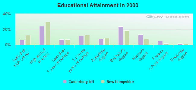
For population 25 years and over in Canterbury:
- High school or higher: 93.9%
- Bachelor's degree or higher: 43.4%
- Graduate or professional degree: 19.7%
- Unemployed: 2.3%
- Mean travel time to work (commute): 28.4 minutes
| Here: | 11.0 |
| New Hampshire average: | 10.9 |

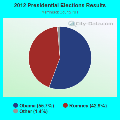
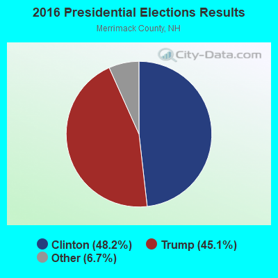
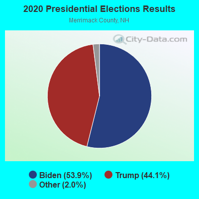
Graphs represent county-level data. Detailed 2008 Election Results
Religion statistics for Canterbury, NH (based on Merrimack County data)
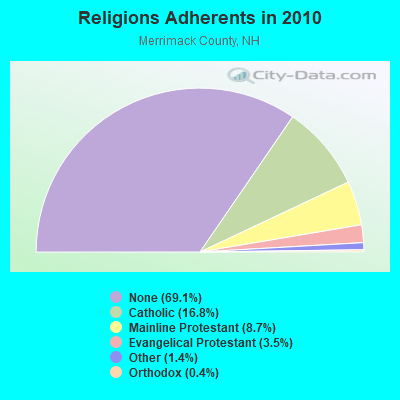
| Religion | Adherents | Congregations |
|---|---|---|
| Catholic | 24,654 | 7 |
| Mainline Protestant | 12,791 | 51 |
| Evangelical Protestant | 5,195 | 36 |
| Other | 2,097 | 15 |
| Orthodox | 580 | 2 |
| None | 101,128 | - |
Food Environment Statistics:
| Merrimack County: | 1.82 / 10,000 pop. |
| State: | 2.14 / 10,000 pop. |
| Merrimack County: | 0.14 / 10,000 pop. |
| New Hampshire: | 0.15 / 10,000 pop. |
| Merrimack County: | 1.22 / 10,000 pop. |
| New Hampshire: | 1.78 / 10,000 pop. |
| Merrimack County: | 4.39 / 10,000 pop. |
| New Hampshire: | 4.02 / 10,000 pop. |
| Merrimack County: | 7.77 / 10,000 pop. |
| New Hampshire: | 9.70 / 10,000 pop. |
| Merrimack County: | 7.4% |
| New Hampshire: | 7.6% |
| Merrimack County: | 23.8% |
| State: | 24.4% |
| This county: | 16.9% |
| New Hampshire: | 15.9% |
Strongest AM radio stations in Canterbury:
- WEZS (1350 AM; 5 kW; LACONIA, NH; Owner: GARY W. HAMMOND)
- WRKO (680 AM; 50 kW; BOSTON, MA; Owner: ENTERCOM BOSTON LICENSE, LLC)
- WGIR (610 AM; 5 kW; MANCHESTER, NH; Owner: CAPSTAR TX LIMITED PARTNERSHIP)
- WGIN (930 AM; 10 kW; ROCHESTER, NH; Owner: CAPSTAR TX LIMITED PARTNERSHIP)
- WFTN (1240 AM; 1 kW; FRANKLIN, NH; Owner: NORTHEAST COMMUNICATIONS CORPORATION)
- WEEI (850 AM; 50 kW; BOSTON, MA; Owner: ENTERCOM BOSTON LICENSE, LLC)
- WNTK (1020 AM; 10 kW; NEWPORT, NH; Owner: KOOR COMMUNICATIONS, INC.)
- WCRN (830 AM; 50 kW; WORCESTER, MA; Owner: CARTER BROADCASTING CORPORATION)
- WKOX (1200 AM; 50 kW; FRAMINGHAM, MA; Owner: CAPSTAR TX LIMITED PARTNERSHIP)
- WKBR (1250 AM; 5 kW; MANCHESTER, NH; Owner: DEVON BROADCASTING COMPANY, INC.)
- WBZ (1030 AM; 50 kW; BOSTON, MA; Owner: INFINITY BROADCASTING OPERATIONS, INC.)
- WNNZ (640 AM; 50 kW; WESTFIELD, MA; Owner: CLEAR CHANNEL BROADCASTING LICENSES, INC.)
- WWZN (1510 AM; 50 kW; BOSTON, MA; Owner: ROSE CITY RADIO CORPORATION)
Strongest FM radio stations in Canterbury:
- WNHI (93.3 FM; BELMONT, NH; Owner: CONCORD BROADCASTING, L.L.C.)
- WJYY (105.5 FM; CONCORD, NH; Owner: CONCORD BROADCASTING, L.L.C.)
- WVNH (91.1 FM; CONCORD, NH; Owner: NEW HAMPSHIRE GOSPEL RADIO, INC.)
- W282AF (104.3 FM; CONCORD, NH; Owner: CONCORD BIBLE FELLOWSHIP)
- WLKZ (104.9 FM; WOLFEBORO, NH; Owner: TELE-MEDIA COMPANY OF NEW HAMPSHIRE, L.L.C.)
- WFTN-FM (94.1 FM; FRANKLIN, NH; Owner: NORTHEAST COMMUNICATIONS CORPORATION)
- WSCY (106.9 FM; MOULTONBOROUGH, NH; Owner: NORTHEAST COMMUNICATIONS CORPORATION)
- WEVO (89.1 FM; CONCORD, NH; Owner: NEW HAMPSHIRE PUBLIC RADIO)
- WHDQ (106.1 FM; CLAREMONT, NH; Owner: GREAT NORTHERN RADIO, L.L.C.)
- WOTX-FM (102.3 FM; CONCORD, NH; Owner: CAPITOL B/CING. INCORPORATION, INC.)
- WMEX (106.5 FM; FARMINGTON, NH; Owner: WIMMEX, LLC)
- WNNH (99.1 FM; HENNIKER, NH; Owner: TELE-MEDIA COMPANY OF NEW HAMPSHIRE, L.L.C.)
- WPKQ (103.7 FM; NORTH CONWAY, NH; Owner: CITADEL BROADCASTING COMPANY)
- WHOM (94.9 FM; MT. WASHINGTON, NH; Owner: CITADEL BROADCASTING COMPANY)
- WGIR-FM (101.1 FM; MANCHESTER, NH; Owner: CAPSTAR TX LIMITED PARTNERSHIP)
- WPNH-FM (100.1 FM; PLYMOUTH, NH; Owner: NORTHEAST COMMUNICATIONS CORPORATION)
- WVFM (105.7 FM; CAMPTON, NH; Owner: DEVON BROADCASTING COMPANY, INC.)
- WQLL (96.5 FM; BEDFORD, NH; Owner: SAGA COMMUNICATIONS OF NEW ENGLAND, LLC)
- WVPR (89.5 FM; WINDSOR, VT; Owner: VERMONT PUBLIC RADIO)
- WLMW (90.7 FM; MANCHESTER, NH; Owner: KNOWLEDGE FOR LIFE)
TV broadcast stations around Canterbury:
- WMEA-TV (Channel 26; BIDDEFORD, ME; Owner: MAINE PUBLIC BROADCASTING CORP.)
- WENH-TV (Channel 11; DURHAM, NH; Owner: UNIVERSITY OF NEW HAMPSHIRE)
- WMTW-TV (Channel 8; POLAND SPRING, ME; Owner: WMTW BROADCAST GROUP, LLC)
- WPXG (Channel 21; CONCORD, NH; Owner: PAXSON BOSTON-68 LICENSE, INC.)
- W39AR (Channel 39; CONCORD, NH; Owner: CENTER B/CING. CORPORATION OF NEW HAMPSHIRE)
- Canterbury, New Hampshire
- Fatal accident count39
- Vehicles involved in fatal accidents49
- Fatal accidents involving drunk persons:11
- Fatalities41
- Persons involved in fatal accidents81
- Pedestrians involved in fatal accidents0
- New Hampshire average
- Fatal accident count2869
- Vehicles involved in fatal accidents4230
- Fatal accidents involving drunk persons1019
- Fatalities3120
- Persons involved in fatal accidents6447
- Pedestrians involved in fatal accidents313
- National Bridge Inventory (NBI) Statistics
- 4Number of bridges
- 13ft / 4.0mTotal length
- $12,568,000Total costs
- 40,495Total average daily traffic
- 3,280Total average daily truck traffic
- 59,930Total future (year 2042) average daily traffic
FCC Registered Antenna Towers:
3- Edward G Roach, 129 Intervale Road (Lat: 43.340806 Lon: -71.620056), Type: 56.3, Overall height: 56.3 m, Registrant: Sba Properties, Inc., Eroach@sbasite.Com, , Boca -Raton, Phone: (800) 487-7483
- Edward G Roach, 129 Intervale Road (Lat: 43.340806 Lon: -71.620056), Type: 56.3, Overall height: 56.3 m, Registrant: Sba Properties, Inc., Eroach@sbasite.Com, , Boca -Raton, Phone: (800) 487-7483
- Edward G Roach, 129 Intervale Road (Lat: 43.340806 Lon: -71.620056), Type: 56.3, Structure height: 33013 m, Overall height: 56.3 m, Registrant: Sba Properties, LLC, Eroach@sbasite.Com, , Boca -Raton, Phone: (561) 995-7670
FCC Registered Broadcast Land Mobile Towers:
5- Fire Station, 26 Baptist Rd. (Lat: 43.337056 Lon: -71.559778), Type: Tower, Structure height: 15.2 m, Overall height: 18.3 m, Call Sign: KVN514,
Assigned Frequencies: 154.235 MHz, 154.355 MHz, Grant Date: 08/25/2021, Expiration Date: 09/20/2031, Registrant: Business Radio Licensing, 30251 Golden Lantern, Suite E # 501, Laguna Niguel, CA 92677, Phone: (949) 348-8510, Fax: (949) 348-8514, Email:
- Canterbury Rest Area I93 (Lat: 43.372028 Lon: -71.608139), Call Sign: WGC611, Licensee ID: L00307774,
Assigned Frequencies: 458.675 MHz, 458.975 MHz, Grant Date: 08/06/2014, Expiration Date: 09/28/2024, Registrant: State Of New Hampshire, Department Of Transportation, Division Of Operations, Seven Hazen Drive, Concord, NH 03302-0483, Phone: (603) 271-6862, Fax: (603) 271-8626, Email:
- Lat: 43.345056 Lon: -71.583944, Call Sign: WPVI741,
Assigned Frequencies: 452.187 MHz, 457.187 MHz, Grant Date: 06/24/2002, Expiration Date: 06/24/2012, Cancellation Date: 08/25/2012, Certifier: Stephen Malloy, Registrant: Cara Enterprises Inc, Salt Lake City, UT 84117-0503, Phone: (801) 278-9728, Fax: (801) 278-7239
- Lat: 43.189889 Lon: -71.480250, Call Sign: WRMD445,
Assigned Frequencies: 160.027 MHz, 160.042 MHz, 173.225 MHz, 173.275 MHz, 173.325 MHz, 160.027 MHz, 160.042 MHz, 173.225 MHz, 173.275 MHz, 173.325 MHz, Grant Date: 03/23/2021, Expiration Date: 03/23/2031, Certifier: Christopher M Rousseau, Registrant: 2-Way Communications Service, Inc., 19 Durham Street, Portsmouth, NH 03801-2872, Phone: (603) 431-6288, Email:
- Lat: 43.346500 Lon: -71.604556, Call Sign: WRWV223,
Assigned Frequencies: 462.312 MHz, 467.312 MHz, 462.412 MHz, 467.412 MHz, Grant Date: 03/31/2023, Expiration Date: 03/31/2033, Certifier: Steve Glines, Registrant: Cara Enterprises, Inc., Las Vegas, NV 89140, Phone: (702) 838-9728, Fax: (702) 363-4607, Email:
FCC Registered Microwave Towers:
1- CANTERBURY, 129 Intervale Road (Lat: 43.340806 Lon: -71.620056), Type: Mtower, Structure height: 56.4 m, Call Sign: WQUI967,
Assigned Frequencies: 11265.0 MHz, Grant Date: 07/22/2014, Expiration Date: 07/22/2024, Certifier: John E Monday, Registrant: At&t Services, Inc., 208 S Akard St, 20f, Dallas, TX 75202, Phone: (855) 699-7073, Fax: (214) 746-6410, Email:
FCC Registered Amateur Radio Licenses:
25 (See the full list of FCC Registered Amateur Radio Licenses in Canterbury)FAA Registered Aircraft:
2- Aircraft: PIPER PA-28-180 (Category: Land, Seats: 4, Weight: Up to 12,499 Pounds, Speed: 107 mph), Engine: LYCOMING O&VO-360 SER (180 HP) (Reciprocating)
N-Number: 15322, N15322, N-15322, Serial Number: 28-7305056, Year manufactured: 1972, Airworthiness Date: 10/26/1972, Certificate Issue Date: 03/08/2019
Registrant (Individual): Josef P Ofner, 448 Shaker Rd, Canterbury, NH 03224 - Aircraft: AIRBORNE CLASSIC (Category: Land, Seats: 2, Weight: Up to 12,499 Pounds), Engine: ROTAX 582SER (65 HP) (2 Cycle)
N-Number: 582YA, N582YA, N-582YA, Serial Number: 582-991, Airworthiness Date: 05/10/2007, Certificate Issue Date: 05/12/2020
Registrant (Individual): David S Rauseo, 152 Morrill Rd, Canterbury, NH 03224
Deregistered: Cancel Date: 08/13/2012
2002 - 2018 National Fire Incident Reporting System (NFIRS) incidents
- Fire incident types reported to NFIRS in Canterbury, NH
- 16758.0%Structure Fires
- 6221.5%Outside Fires
- 5318.4%Mobile Property/Vehicle Fires
- 62.1%Other
 According to the data from the years 2002 - 2018 the average number of fires per year is 17. The highest number of reported fire incidents - 37 took place in 2015, and the least - 5 in 2017. The data has a growing trend.
 When looking into fire subcategories, the most reports belonged to: Structure Fires (58.0%), and Outside Fires (21.5%).
- 63.5%Fuel oil, kerosene, etc.
- 16.1%Bottled, tank, or LP gas
- 16.0%Wood
- 1.9%Utility gas
- 1.5%Solar energy
- 1.0%Electricity
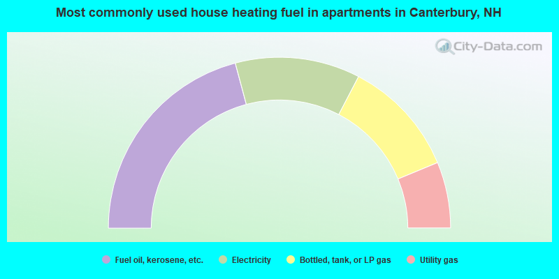
- 41.7%Fuel oil, kerosene, etc.
- 23.6%Electricity
- 22.2%Bottled, tank, or LP gas
- 12.5%Utility gas
Canterbury compared to New Hampshire state average:
- Unemployed percentage significantly below state average.
- Black race population percentage below state average.
- Hispanic race population percentage below state average.
- Foreign-born population percentage significantly below state average.
- Renting percentage significantly below state average.
- Length of stay since moving in significantly above state average.
- Number of rooms per house significantly below state average.
- House age significantly below state average.

|
|
Total of 52 patent applications in 2008-2024.