Blackstone, Massachusetts
Submit your own pictures of this town and show them to the world
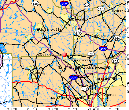
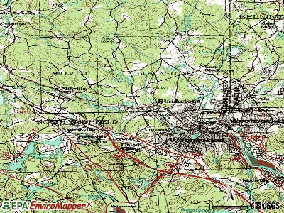
- OSM Map
- General Map
- Google Map
- MSN Map
Population change since 2000: +2.5%
 |
| Males: 4,352 | |
| Females: 4,674 |
| Median resident age: | 39.8 years |
| Massachusetts median age: | 39.2 years |
Zip codes: 01504.
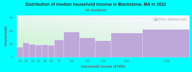
| Blackstone: | $99,391 |
| MA: | $94,488 |
Estimated per capita income in 2022: $40,821 (it was $20,936 in 2000)
Blackstone town income, earnings, and wages data
Estimated median house or condo value in 2022: $400,152 (it was $144,900 in 2000)
| Blackstone: | $400,152 |
| MA: | $534,700 |
Mean prices in 2022: all housing units: $419,164; detached houses: $447,621; townhouses or other attached units: $343,592; in 2-unit structures: $323,295; in 3-to-4-unit structures: $332,295; in 5-or-more-unit structures: $232,758; mobile homes: $113,885
Detailed information about poverty and poor residents in Blackstone, MA


- 8,55594.8%White alone
- 1852.0%Hispanic
- 1091.2%Two or more races
- 770.9%Black alone
- 710.8%Asian alone
- 210.2%American Indian alone
- 50.06%Other race alone
- 30.03%Native Hawaiian and Other
Pacific Islander alone
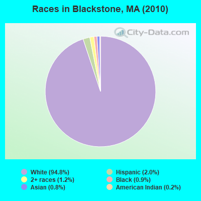
Races in Blackstone detailed stats: ancestries, foreign born residents, place of birth
According to our research of Massachusetts and other state lists, there were 9 registered sex offenders living in Blackstone, Massachusetts as of May 07, 2024.
The ratio of all residents to sex offenders in Blackstone is 1,003 to 1.
Type |
2009 |
2010 |
2011 |
2012 |
2013 |
2014 |
2015 |
2016 |
2017 |
2018 |
2019 |
2020 |
2021 |
2022 |
|---|---|---|---|---|---|---|---|---|---|---|---|---|---|---|
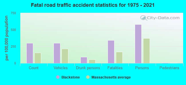
| Murders (per 100,000) | 0 (0.0) | 0 (0.0) | 0 (0.0) | 0 (0.0) | 0 (0.0) | 0 (0.0) | 0 (0.0) | 0 (0.0) | 0 (0.0) | 0 (0.0) | 0 (0.0) | 0 (0.0) | 0 (0.0) | 0 (0.0) |
| Rapes (per 100,000) | 1 (11.0) | 2 (22.2) | 1 (11.0) | 0 (0.0) | 3 (33.0) | 1 (11.0) | 1 (11.0) | 1 (11.0) | 1 (11.0) | 1 (10.7) | 1 (10.8) | 1 (10.8) | 2 (21.5) | 1 (10.8) |
| Robberies (per 100,000) | 1 (11.0) | 1 (11.1) | 0 (0.0) | 2 (21.9) | 2 (22.0) | 0 (0.0) | 2 (22.0) | 1 (11.0) | 1 (11.0) | 1 (10.7) | 2 (21.5) | 1 (10.8) | 0 (0.0) | 0 (0.0) |
| Assaults (per 100,000) | 9 (98.6) | 19 (210.5) | 14 (154.2) | 13 (142.3) | 12 (132.0) | 4 (43.9) | 13 (142.7) | 10 (110.1) | 11 (121.2) | 1 (10.7) | 10 (107.6) | 6 (64.7) | 6 (64.5) | 4 (43.4) |
| Burglaries (per 100,000) | 20 (219.2) | 17 (188.3) | 19 (209.2) | 12 (131.3) | 20 (219.9) | 16 (175.5) | 6 (65.9) | 13 (143.2) | 11 (121.2) | 11 (117.7) | 5 (53.8) | 1 (10.8) | 4 (43.0) | 1 (10.8) |
| Thefts (per 100,000) | 85 (931.4) | 74 (819.9) | 103 (1,134) | 102 (1,116) | 60 (659.8) | 75 (822.5) | 61 (669.6) | 47 (517.7) | 46 (506.7) | 22 (235.4) | 12 (129.1) | 7 (75.5) | 10 (107.5) | 8 (86.7) |
| Auto thefts (per 100,000) | 3 (32.9) | 3 (33.2) | 13 (143.2) | 10 (109.4) | 4 (44.0) | 6 (65.8) | 1 (11.0) | 6 (66.1) | 2 (22.0) | 4 (42.8) | 4 (43.0) | 1 (10.8) | 1 (10.7) | 3 (32.5) |
| Arson (per 100,000) | 3 (32.9) | 0 (0.0) | 0 (0.0) | 2 (21.9) | 0 (0.0) | 0 (0.0) | 0 (0.0) | 0 (0.0) | 0 (0.0) | 0 (0.0) | 0 (0.0) | 0 (0.0) | 0 (0.0) | 0 (0.0) |
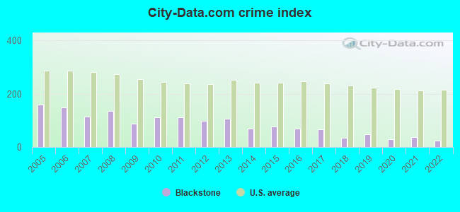
| City-Data.com crime index | 87.0 | 111.8 | 111.1 | 97.6 | 104.7 | 68.0 | 76.2 | 70.2 | 66.9 | 35.0 | 49.0 | 29.5 | 38.3 | 24.2 |
The City-Data.com crime index weighs serious crimes and violent crimes more heavily. Higher means more crime, U.S. average is 246.1. It adjusts for the number of visitors and daily workers commuting into cities.
Crime rate in Blackstone detailed stats: murders, rapes, robberies, assaults, burglaries, thefts, arson
Full-time law enforcement employees in 2021, including police officers: 22 (18 officers - 18 male; 0 female).
| Officers per 1,000 residents here: | 1.93 |
| Massachusetts average: | 2.53 |
 Recent articles from our blog. Our writers, many of them Ph.D. graduates or candidates, create easy-to-read articles on a wide variety of topics.

 | Worcester dumps 879,000 gallons of sewage into Blackstone River (11 replies) |
| 2023 Real Estate Observations (5278 replies) |
| WFH in MA (207 replies) |
| Town in Massachusetts You’d Least Like To Live In? (179 replies) |
| Any restaurants sous vide? (29 replies) |
| Moving Out of the South End. Looking for Suggestions (45 replies) |
Latest news from Blackstone, MA collected exclusively by city-data.com from local newspapers, TV, and radio stations
Ancestries: French Canadian (22.3%), French (21.6%), Irish (20.1%), Italian (15.4%), English (14.4%), Polish (8.5%).
Current Local Time: EST time zone
Incorporated in 1845
Elevation: 186 feet
Land area: 10.9 square miles.
Population density: 828 people per square mile (low).
240 residents are foreign born (1.1% Asia, 0.7% North America, 0.7% Europe).
| This town: | 2.7% |
| Massachusetts: | 12.2% |
| Blackstone town: | 1.3% ($1,928) |
| Massachusetts: | 1.3% ($2,336) |
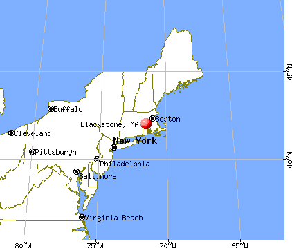
Nearest city with pop. 50,000+: Pawtucket, RI  (13.2 miles , pop. 72,958).
Nearest city with pop. 200,000+: Boston, MA (30.4 miles , pop. 589,141).
Nearest city with pop. 1,000,000+: Bronx, NY (146.4 miles , pop. 1,332,650).
Nearest cities:
), ), ), Latitude: 42.03 N, Longitude: 71.53 W
Area codes: 508, 774

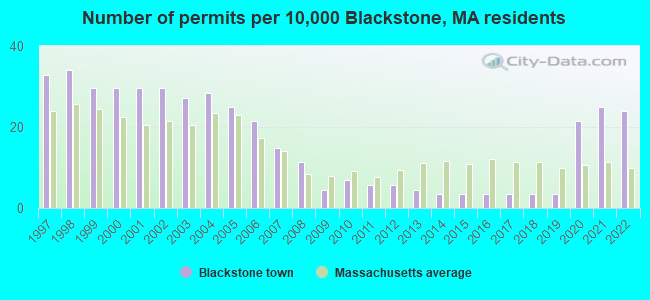
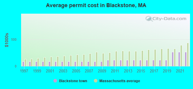
Single-family new house construction building permits:
- 2022: 21 buildings, average cost: $265,300
- 2021: 22 buildings, average cost: $265,300
- 2020: 19 buildings, average cost: $265,300
- 2019: 3 buildings, average cost: $116,500
- 2018: 3 buildings, average cost: $116,500
- 2017: 3 buildings, average cost: $116,500
- 2016: 3 buildings, average cost: $116,500
- 2015: 3 buildings, average cost: $116,500
- 2014: 3 buildings, average cost: $116,500
- 2013: 4 buildings, average cost: $116,500
- 2012: 5 buildings, average cost: $116,500
- 2011: 5 buildings, average cost: $116,500
- 2010: 6 buildings, average cost: $116,500
- 2009: 4 buildings, average cost: $91,000
- 2008: 10 buildings, average cost: $91,000
- 2007: 13 buildings, average cost: $91,000
- 2006: 19 buildings, average cost: $91,000
- 2005: 22 buildings, average cost: $91,000
- 2004: 25 buildings, average cost: $91,000
- 2003: 24 buildings, average cost: $91,000
- 2002: 26 buildings, average cost: $91,000
- 2001: 26 buildings, average cost: $91,000
- 2000: 26 buildings, average cost: $91,000
- 1999: 26 buildings, average cost: $91,000
- 1998: 30 buildings, average cost: $91,200
- 1997: 29 buildings, average cost: $88,400
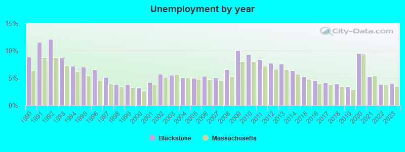
| Here: | 4.1% |
| Massachusetts: | 3.5% |
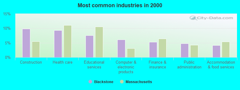
- Construction (9.8%)
- Health care (9.3%)
- Educational services (7.6%)
- Computer & electronic products (6.1%)
- Finance & insurance (5.3%)
- Public administration (4.8%)
- Accommodation & food services (4.2%)
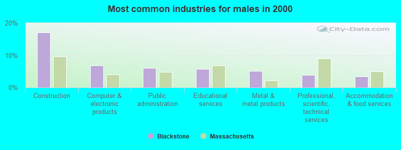
- Construction (17.1%)
- Computer & electronic products (6.8%)
- Public administration (6.0%)
- Educational services (5.8%)
- Metal & metal products (5.1%)
- Professional, scientific, technical services (3.9%)
- Accommodation & food services (3.4%)
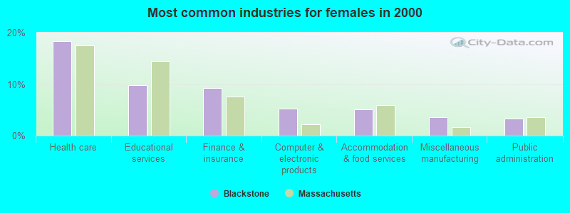
- Health care (18.4%)
- Educational services (9.7%)
- Finance & insurance (9.2%)
- Computer & electronic products (5.3%)
- Accommodation & food services (5.1%)
- Miscellaneous manufacturing (3.5%)
- Public administration (3.3%)
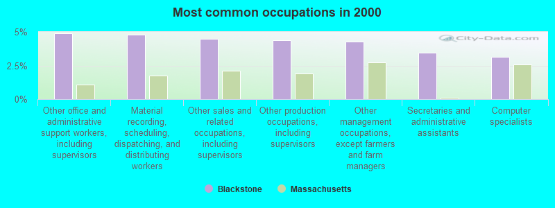
- Other office and administrative support workers, including supervisors (4.9%)
- Material recording, scheduling, dispatching, and distributing workers (4.8%)
- Other sales and related occupations, including supervisors (4.5%)
- Other production occupations, including supervisors (4.4%)
- Other management occupations, except farmers and farm managers (4.3%)
- Secretaries and administrative assistants (3.4%)
- Computer specialists (3.1%)
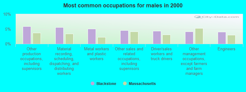
- Other production occupations, including supervisors (5.8%)
- Material recording, scheduling, dispatching, and distributing workers (5.5%)
- Metal workers and plastic workers (5.0%)
- Other sales and related occupations, including supervisors (4.5%)
- Driver/sales workers and truck drivers (4.4%)
- Other management occupations, except farmers and farm managers (4.1%)
- Engineers (4.0%)
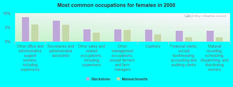
- Other office and administrative support workers, including supervisors (8.7%)
- Secretaries and administrative assistants (7.6%)
- Other sales and related occupations, including supervisors (4.4%)
- Other management occupations, except farmers and farm managers (4.4%)
- Cashiers (4.3%)
- Financial clerks, except bookkeeping, accounting and auditing clerks (3.9%)
- Material recording, scheduling, dispatching, and distributing workers (3.9%)
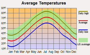
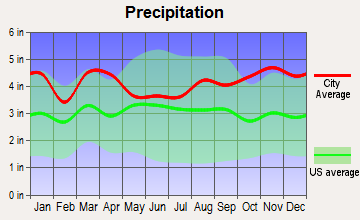
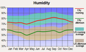
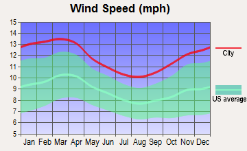
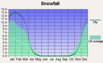
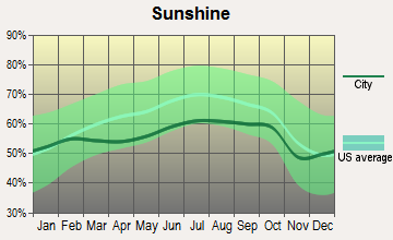
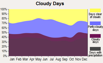
Average climate in Blackstone, Massachusetts
Based on data reported by over 4,000 weather stations
(lower is better)
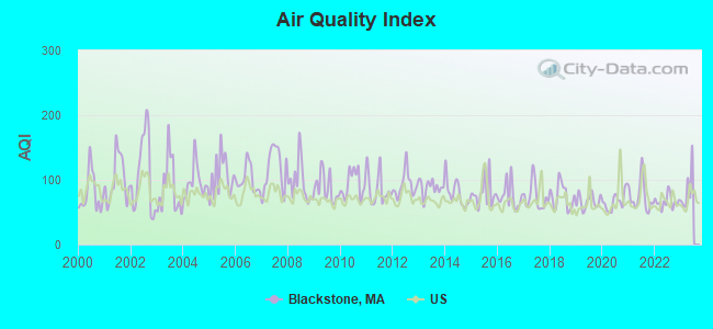
Air Quality Index (AQI) level in 2022 was 66.0. This is about average.
| City: | 66.0 |
| U.S.: | 72.6 |
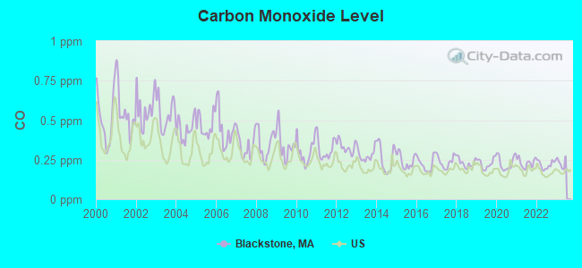
Carbon Monoxide (CO) [ppm] level in 2022 was 0.218. This is about average. Closest monitor was 12.8 miles away from the city center.
| City: | 0.218 |
| U.S.: | 0.251 |
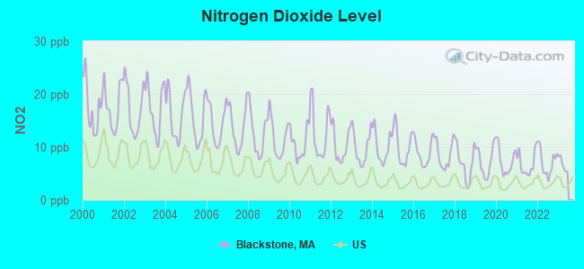
Nitrogen Dioxide (NO2) [ppb] level in 2022 was 7.10. This is worse than average. Closest monitor was 2.2 miles away from the city center.
| City: | 7.10 |
| U.S.: | 5.11 |
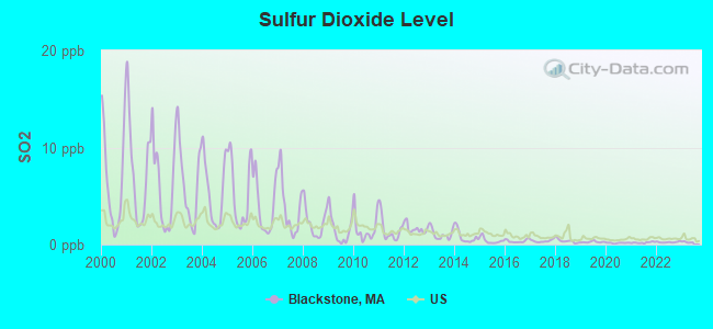
Sulfur Dioxide (SO2) [ppb] level in 2022 was 0.246. This is significantly better than average. Closest monitor was 2.2 miles away from the city center.
| City: | 0.246 |
| U.S.: | 1.515 |
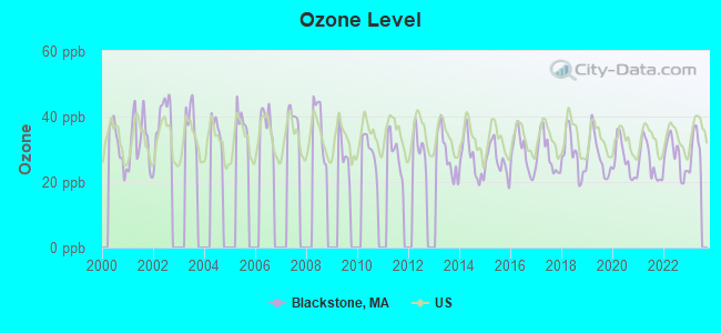
Ozone [ppb] level in 2022 was 27.7. This is better than average. Closest monitor was 6.8 miles away from the city center.
| City: | 27.7 |
| U.S.: | 33.3 |
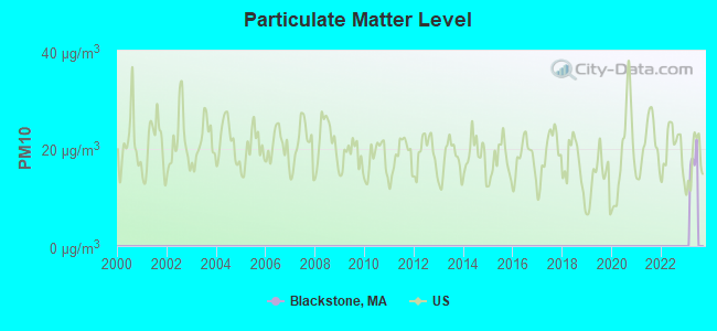
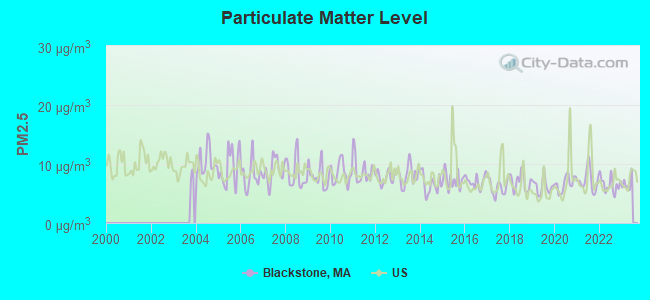
Particulate Matter (PM2.5) [µg/m3] level in 2022 was 6.52. This is better than average. Closest monitor was 10.8 miles away from the city center.
| City: | 6.52 |
| U.S.: | 8.11 |
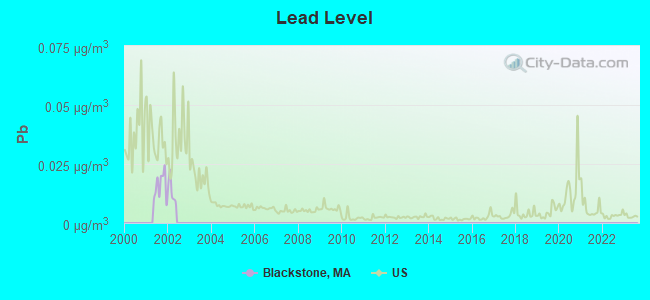
Lead (Pb) [µg/m3] level in 2001 was 0.0157. This is significantly worse than average. Closest monitor was 13.1 miles away from the city center.
| City: | 0.0157 |
| U.S.: | 0.0093 |
Tornado activity:
Blackstone-area historical tornado activity is near Massachusetts state average. It is 36% smaller than the overall U.S. average.
On 6/9/1953, a category F4 (max. wind speeds 207-260 mph) tornado 18.8 miles away from the Blackstone town center killed 90 people and injured 1228 people and caused between $50,000,000 and $500,000,000 in damages.
On 6/9/1953, a category F3 (max. wind speeds 158-206 mph) tornado 15.7 miles away from the town center injured 17 people and caused between $500,000 and $5,000,000 in damages.
Earthquake activity:
Blackstone-area historical earthquake activity is significantly above Massachusetts state average. It is 73% smaller than the overall U.S. average.On 10/7/1983 at 10:18:46, a magnitude 5.3 (5.1 MB, 5.3 LG, 5.1 ML, Class: Moderate, Intensity: VI - VII) earthquake occurred 194.8 miles away from the city center
On 4/20/2002 at 10:50:47, a magnitude 5.3 (5.3 ML, Depth: 3.0 mi) earthquake occurred 203.5 miles away from the city center
On 4/20/2002 at 10:50:47, a magnitude 5.2 (5.2 MB, 4.2 MS, 5.2 MW, 5.0 MW) earthquake occurred 202.6 miles away from Blackstone center
On 1/19/1982 at 00:14:42, a magnitude 4.7 (4.5 MB, 4.7 MD, 4.5 LG, Class: Light, Intensity: IV - V) earthquake occurred 101.9 miles away from the city center
On 10/16/2012 at 23:12:25, a magnitude 4.7 (4.7 ML, Depth: 10.0 mi) earthquake occurred 117.2 miles away from Blackstone center
On 8/22/1992 at 12:20:32, a magnitude 4.8 (4.8 MB, 3.8 MS, 4.7 LG, Depth: 6.2 mi) earthquake occurred 211.9 miles away from the city center
Magnitude types: regional Lg-wave magnitude (LG), body-wave magnitude (MB), duration magnitude (MD), local magnitude (ML), surface-wave magnitude (MS), moment magnitude (MW)
Natural disasters:
The number of natural disasters in Worcester County (27) is a lot greater than the US average (15).Major Disasters (Presidential) Declared: 15
Emergencies Declared: 12
Causes of natural disasters: Floods: 9, Storms: 8, Hurricanes: 6, Snowstorms: 5, Winter Storms: 4, Blizzards: 2, Snows: 2, Fire: 1, Heavy Rain: 1, Snowfall: 1, Tornado: 1, Wind: 1 (Note: some incidents may be assigned to more than one category).
Hospitals and medical centers in Blackstone:
Other hospitals and medical centers near Blackstone:
- ST ANTOINE RESIDENCE (Nursing Home, about 2 miles away; NORTH SMITHFIELD, RI)
- FRIENDLY HOME INC, THE (Nursing Home, about 2 miles away; WOONSOCKET, RI)
- EVERGREENS NURSING HOME (Nursing Home, about 3 miles away; WOONSOCKET, RI)
- LANDMARK MEDICAL CENTER, INC Acute Care Hospitals (about 3 miles away; WOONSOCKET, RI)
- TRINITY HEALTH AND REHABILITATION CENTER (Nursing Home, about 3 miles away; WOONSOCKET, RI)
- BALLOU HOME FOR THE AGED (Nursing Home, about 3 miles away; WOONSOCKET, RI)
- WOONSOCKET HEALTH CENTRE (Nursing Home, about 3 miles away; WOONSOCKET, RI)
Amtrak stations near Blackstone:
- 16 miles: PROVIDENCE (100 GASPEE ST.) . Services: ticket office, fully wheelchair accessible, enclosed waiting area, public restrooms, public payphones, snack bar, ATM, paid short-term parking, paid long-term parking, call for car rental service, taxi stand, public transit connection.
- 19 miles: FRAMINGHAM (443 WAVERLY ST.) . Services: public payphones, snack bar, paid short-term parking, taxi stand, public transit connection.
Colleges/universities with over 2000 students nearest to Blackstone:
- Bryant University (about 8 miles; Smithfield, RI; Full-time enrollment: 3,440)
- Rhode Island College (about 14 miles; Providence, RI; FT enrollment: 7,189)
- Providence College (about 14 miles; Providence, RI; FT enrollment: 4,312)
- Brown University (about 16 miles; Providence, RI; FT enrollment: 8,458)
- Rhode Island School of Design (about 16 miles; Providence, RI; FT enrollment: 2,714)
- Johnson & Wales University-Providence (about 16 miles; Providence, RI; FT enrollment: 10,898)
- Framingham State University (about 20 miles; Framingham, MA; FT enrollment: 5,743)
Public high school in Blackstone:
- BLACKSTONE MILLVILLE RHS (Students: 601, Location: 175 LINCOLN STREET, Grades: 9-12)
Public elementary/middle schools in Blackstone:
- FREDERICK W. HARTNETT MIDDLE SCHOOL (Students: 542, Location: 35 FEDERAL STREET, Grades: 6-8)
- JOHN F KENNEDY ELEMENTARY (Students: 444, Location: 200 LINCOLN STREET, Grades: KG-3)
- A F MALONEY (Students: 214, Location: 200 LINCOLN STREET, Grades: 4-5)
Points of interest:
Notable locations in Blackstone: Wojcik Farm (A), Blackstone Fire Department Station 2 (B), Blackstone Fire Department Station 1 Headquarters (C), Millville Town Hall (D), Blackstone Town Hall (E). Display/hide their locations on the map
Shopping Center: Allouette Plaza Shopping Center (1). Display/hide its location on the map
Churches in Blackstone include: Friends Church (A), Blackstone Federated Church (B). Display/hide their locations on the map
Cemeteries: Blackstone Cemetery (1), Saint Charles Cemetery (2), Saint Stanislaus Cemetery (3), Precious Blood Cemetery (4), Saint Micheals Cemetery (5). Display/hide their locations on the map
Lakes and reservoirs: Reilly Pond (A), Walsh Pond (B), Crane Pond (C), Duck Pond (D), Fish Pond (E), Briggs Pond (F), Forge Pond (G), Blackstone River Reservoir (H). Display/hide their locations on the map
Streams, rivers, and creeks: Aldrich Brook (A), Hop Brook (B), Quick Stream (C), Fox Brook (D). Display/hide their locations on the map
Birthplace of: Fernand St. Germain - Politician, Bob Stewart (umpire) - Baseball umpire, Eddie Eayrs - Baseball player and coach.
Drinking water stations with addresses in Blackstone and their reported violations in the past:
BLACKSTONE WATER DEPARTMENT (Population served: 8,923, Groundwater):Past health violations:Past monitoring violations:
- MCL, Monthly (TCR) - In NOV-2012, Contaminant: Coliform. Follow-up actions: St AO (w/o penalty) issued (JAN-28-2013), St Compliance achieved (JAN-28-2013)
- MCL, Monthly (TCR) - In OCT-2010, Contaminant: Coliform. Follow-up actions: St AO (w/o penalty) issued (FEB-04-2011), St Compliance achieved (FEB-04-2011)
- MCL, Monthly (TCR) - In NOV-2009, Contaminant: Coliform. Follow-up actions: St AO (w/o penalty) issued (JAN-14-2010)
- Monitoring and Reporting (DBP) - Between APR-2009 and JUN-2009, Contaminant: Chlorine. Follow-up actions: St AO (w/o penalty) issued (SEP-03-2009), St Compliance achieved (MAY-19-2010)
- Monitoring and Reporting (DBP) - Between JAN-2009 and MAR-2009, Contaminant: Chlorine. Follow-up actions: St AO (w/o penalty) issued (MAY-22-2009), St Compliance achieved (JUN-10-2009)
- Follow-up Or Routine LCR Tap M/R - In JUL-01-2008, Contaminant: Lead and Copper Rule. Follow-up actions: St AO (w/o penalty) issued (DEC-05-2008), St Compliance achieved (JUL-20-2010)
- One routine major monitoring violation
- One minor monitoring violation
- 26 regular monitoring violations
| This town: | 2.6 people |
| Massachusetts: | 2.5 people |
| This town: | 71.3% |
| Whole state: | 63.0% |
| This town: | 7.6% |
| Whole state: | 7.0% |
Likely homosexual households (counted as self-reported same-sex unmarried-partner households)
- Lesbian couples: 0.4% of all households
- Gay men: 0.1% of all households
| This town: | 3.7% |
| Whole state: | 9.3% |
| This town: | 2.5% |
| Whole state: | 4.4% |
18 people in workers' group living quarters and job corps centers in 2010
25 people in nursing homes in 2000
7 people in other noninstitutional group quarters in 2000
Banks with branches in Blackstone (2011 data):
- UniBank for Savings: Blackstone Branch at 10 Cheney Street, branch established on 1966/11/15. Info updated 2008/03/03: Bank assets: $1,263.1 mil, Deposits: $1,151.5 mil, headquarters in Whitinsville, MA, positive income, 8 total offices, Holding Company: Ufs Bancorp
- Dean Co-operative Bank: Blackstone Branch at 8 Main Street, branch established on 1997/11/05. Info updated 2006/11/03: Bank assets: $223.1 mil, Deposits: $183.8 mil, headquarters in Franklin, MA, positive income, Mortgage Lending Specialization, 5 total offices
For population 15 years and over in Blackstone:
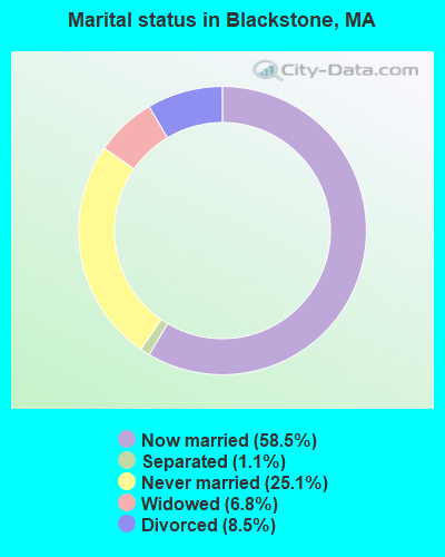
- Never married: 25.1%
- Now married: 58.5%
- Separated: 1.1%
- Widowed: 6.8%
- Divorced: 8.5%
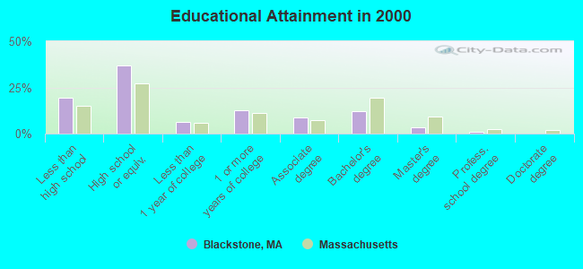
For population 25 years and over in Blackstone:
- High school or higher: 80.7%
- Bachelor's degree or higher: 16.3%
- Graduate or professional degree: 4.4%
- Unemployed: 1.8%
- Mean travel time to work (commute): 28.1 minutes
| Here: | 11.2 |
| Massachusetts average: | 13.1 |


Graphs represent county-level data. Detailed 2008 Election Results
Religion statistics for Blackstone, MA (based on Worcester County data)


| Religion | Adherents | Congregations |
|---|---|---|
| Catholic | 306,925 | 118 |
| Mainline Protestant | 43,326 | 171 |
| Evangelical Protestant | 37,511 | 203 |
| Other | 18,931 | 69 |
| Orthodox | 7,935 | 15 |
| Black Protestant | 497 | 6 |
| None | 383,427 | - |
Food Environment Statistics:
| Worcester County: | 1.73 / 10,000 pop. |
| Massachusetts: | 1.98 / 10,000 pop. |
| Worcester County: | 0.05 / 10,000 pop. |
| Massachusetts: | 0.05 / 10,000 pop. |
| Worcester County: | 1.79 / 10,000 pop. |
| State: | 2.22 / 10,000 pop. |
| This county: | 2.22 / 10,000 pop. |
| Massachusetts: | 1.77 / 10,000 pop. |
| This county: | 7.27 / 10,000 pop. |
| Massachusetts: | 8.76 / 10,000 pop. |
| Worcester County: | 8.0% |
| State: | 8.1% |
| Worcester County: | 24.0% |
| Massachusetts: | 22.5% |
| Worcester County: | 16.6% |
| Massachusetts: | 16.5% |
4.71% of this county's 2021 resident taxpayers lived in other counties in 2020 ($76,229 average adjusted gross income)
| Here: | 4.71% |
| Massachusetts average: | 6.35% |
0.02% of residents moved from foreign countries ($100 average AGI)
Worcester County: 0.02% Massachusetts average: 0.01%
Top counties from which taxpayers relocated into this county between 2020 and 2021:
| from Middlesex County, MA | |
| from Norfolk County, MA | |
| from Suffolk County, MA |
4.84% of this county's 2020 resident taxpayers moved to other counties in 2021 ($87,252 average adjusted gross income)
| Here: | 4.84% |
| Massachusetts average: | 7.18% |
0.03% of residents moved to foreign countries ($199 average AGI)
Worcester County: 0.03% Massachusetts average: 0.02%
Top counties to which taxpayers relocated from this county between 2020 and 2021:
| to Middlesex County, MA | |
| to Norfolk County, MA | |
| to Suffolk County, MA |
| Businesses in Blackstone, MA | ||||
| Name | Count | Name | Count | |
|---|---|---|---|---|
| 7-Eleven | 1 | Subway | 1 | |
| CVS | 1 | U-Haul | 2 | |
| Dunkin Donuts | 1 | UPS | 1 | |
| MasterBrand Cabinets | 2 | |||
Strongest AM radio stations in Blackstone:
- WALE (990 AM; 50 kW; GREENVILLE, RI; Owner: NORTH AMERICAN BROADCASTING CO., INC.)
- WNRI (1380 AM; 2 kW; WOONSOCKET, RI; Owner: ANASTOS MEDIA GROUP, INC.)
- WOON (1240 AM; 1 kW; WOONSOCKET, RI; Owner: O-N RADIO, INC.)
- WKOX (1200 AM; 50 kW; FRAMINGHAM, MA; Owner: CAPSTAR TX LIMITED PARTNERSHIP)
- WEEI (850 AM; 50 kW; BOSTON, MA; Owner: ENTERCOM BOSTON LICENSE, LLC)
- WBIX (1060 AM; 40 kW; NATICK, MA; Owner: LANGER BROADCASTING CORPORATION)
- WAMG (890 AM; 25 kW; DEDHAM, MA; Owner: MEGA COMMUNICATIONS OF DEDHAM LICENSEE, LLC)
- WCRN (830 AM; 50 kW; WORCESTER, MA; Owner: CARTER BROADCASTING CORPORATION)
- WDDZ (550 AM; 5 kW; PAWTUCKET, RI; Owner: ABC, INC.)
- WRKO (680 AM; 50 kW; BOSTON, MA; Owner: ENTERCOM BOSTON LICENSE, LLC)
- WRNI (1290 AM; 10 kW; PROVIDENCE, RI; Owner: WRNI FOUNDATION)
- WWZN (1510 AM; 50 kW; BOSTON, MA; Owner: ROSE CITY RADIO CORPORATION)
- WBZ (1030 AM; 50 kW; BOSTON, MA; Owner: INFINITY BROADCASTING OPERATIONS, INC.)
Strongest FM radio stations in Blackstone:
- WWKX (106.3 FM; WOONSOCKET, RI; Owner: AAA ENTERTAINMENT LICENSING LLC)
- WWBB (101.5 FM; PROVIDENCE, RI; Owner: CLEAR CHANNEL BROADCASTING LICENSES, INC.)
- WBMX (98.5 FM; BOSTON, MA; Owner: INFINITY RADIO OPERATIONS INC.)
- WJMN (94.5 FM; BOSTON, MA; Owner: AMFM RADIO LICENSES, L.L.C.)
- WBOS (92.9 FM; BROOKLINE, MA; Owner: GREATER BOSTON RADIO, INC.)
- WCRB (102.5 FM; WALTHAM, MA; Owner: CHARLES RIVER BROADCASTING WCRB LICE)
- WTKK (96.9 FM; BOSTON, MA; Owner: GREATER BOSTON RADIO, INC.)
- WROR-FM (105.7 FM; FRAMINGHAM, MA; Owner: GREATER BOSTON RADIO, INC.)
- WGBH (89.7 FM; BOSTON, MA; Owner: WGBH EDUCATIONAL FOUNDATION)
- WSNE-FM (93.3 FM; TAUNTON, MA; Owner: CAPSTAR TX LIMITED PARTNERSHIP)
- WPRO-FM (92.3 FM; PROVIDENCE, RI; Owner: CITADEL BROADCASTING COMPANY)
- WBUR-FM (90.9 FM; BOSTON, MA; Owner: TRUSTEES OF BOSTON UNIVERSITY)
- WAAF (107.3 FM; WORCESTER, MA; Owner: ENTERCOM BOSTON LICENSE, LLC)
- WWLI (105.1 FM; PROVIDENCE, RI; Owner: CITADEL BROADCASTING COMPANY)
- WGAO (88.3 FM; FRANKLIN, MA; Owner: DEAN COLLEGE)
- WODS (103.3 FM; BOSTON, MA; Owner: INFINITY BROADCASTING OPERATIONS, INC.)
- WBRU (95.5 FM; PROVIDENCE, RI; Owner: BROWN BROADCASTING SERVICE, INC.)
- WXKS-FM (107.9 FM; MEDFORD, MA; Owner: AMFM RADIO LICENSES, L.L.C.)
- WMJX (106.7 FM; BOSTON, MA; Owner: GREATER BOSTON RADIO, INC.)
- WHJY (94.1 FM; PROVIDENCE, RI; Owner: CAPSTAR TX LIMITED PARTNERSHIP)
TV broadcast stations around Blackstone:
- WCVB-TV (Channel 5; BOSTON, MA; Owner: WCVB HEARST-ARGYLE TV, INC.)
- WNAC-TV (Channel 64; PROVIDENCE, RI; Owner: WNAC, LLC)
- WGBH-TV (Channel 2; BOSTON, MA; Owner: WGBH EDUCATIONAL FOUNDATION)
- WPRI-TV (Channel 12; PROVIDENCE, RI; Owner: TVL BROADCASTING OF RHODE ISLAND, LLC)
- WUNI (Channel 27; WORCESTER, MA; Owner: ENTRAVISION HOLDINGS, LLC)
- WJAR (Channel 10; PROVIDENCE, RI; Owner: OUTLET BROADCASTING, INC.)
- WLNE-TV (Channel 6; NEW BEDFORD, MA; Owner: FREEDOM BROADCASTING OF SOUTHERN NEW ENGLAND, INC.)
- WMFP (Channel 62; LAWRENCE, MA; Owner: WSAH LICENSE, INC.)
- WHDH-TV (Channel 7; BOSTON, MA; Owner: WHDH-TV)
- WBZ-TV (Channel 4; BOSTON, MA; Owner: VIACOM INC.)
- WGBX-TV (Channel 44; BOSTON, MA; Owner: WGBH EDUCATIONAL FOUNDATION)
- WSBK-TV (Channel 38; BOSTON, MA; Owner: VIACOM INC.)
- WSBE-TV (Channel 36; PROVIDENCE, RI; Owner: RHODE ISLAND PUBLIC TELECOM. AUTHORITY)
- WLVI-TV (Channel 56; CAMBRIDGE, MA; Owner: WLVI, INC.)
- WUTF (Channel 66; MARLBOROUGH, MA; Owner: TELEFUTURA BOSTON LLC)
- WFXT (Channel 25; BOSTON, MA; Owner: FOX TELEVISION STATIONS INC.)
- WPXQ (Channel 69; BLOCK ISLAND, RI; Owner: OCEAN STATE TELEVISION, L.L.C.)
- WWDP (Channel 46; NORWELL, MA; Owner: NORWELL TELEVISION, LLC)
- W40BO (Channel 40; BOSTON, MA; Owner: PAXSON COMMUNICATIONS LPTV, INC.)
- WRIW-LP (Channel 50; PROVIDENCE, RI; Owner: ZGS PROVIDENCE, INC.)
- WBPX (Channel 68; BOSTON, MA; Owner: PAXSON BOSTON-68 LICENSE, INC.)
- WYDN (Channel 48; WORCESTER, MA; Owner: EDUCATIONAL PUBLIC TV CORPORATION)
- WTMU-LP (Channel 32; BOSTON, MA; Owner: ZGS BOSTON, INC.)
- WCEA-LP (Channel 58; BOSTON, MA; Owner: CHANNEL 19 TV CORPORATION)
- WLWC (Channel 28; NEW BEDFORD, MA; Owner: C-28 FCC LICENSEE SUBSIDIARY, LLC)
- National Bridge Inventory (NBI) Statistics
- 6Number of bridges
- 66ft / 20.2mTotal length
- $15,195,000Total costs
- 30,327Total average daily traffic
- 1,445Total average daily truck traffic
- 64,119Total future (year 2031) average daily traffic
FCC Registered Antenna Towers:
9 (See the full list of FCC Registered Antenna Towers in Blackstone)FCC Registered Broadcast Land Mobile Towers:
7- 15 St. Paul Street (Lat: 42.017333 Lon: -71.533111), Type: Building, Structure height: 8 m, Overall height: 14 m, Call Sign: WQY368,
Assigned Frequencies: 151.475 MHz, 159.330 MHz, Grant Date: 08/31/2015, Expiration Date: 10/09/2025, Registrant: Blackstone Fire Department, 15 St Paul Street, Blackstone, MA 01504, Phone: (508) 883-1030
- TANK, Water Tank Off Bellingham Road (Lat: 42.050167 Lon: -71.504972), Type: Pole, Structure height: 12 m, Overall height: 14.5 m, Call Sign: KNGJ601,
Assigned Frequencies: 156.142 MHz, Grant Date: 03/21/2023, Expiration Date: 06/13/2033, Registrant: Business Radio Licensing, 30251 Golden Lantern, Suite E #501, Laguna Niguel, CA 92677, Phone: (949) 348-8510, Fax: (949) 348-8514, Email:
- Lat: 42.055111 Lon: -71.518667, Call Sign: KNGE884,
Assigned Frequencies: 451.712 MHz, Grant Date: 06/07/2002, Expiration Date: 07/14/2012, Cancellation Date: 09/15/2012, Certifier: Robert W Kimball, Registrant: Budzyna, James, 49 Gill Court, Whitingsville, MA 01588, Phone: (508) 234-6021, Fax: (508) 234-2605, Email:
- 15 St Paul Street (Lat: 42.017306 Lon: -71.533056), Structure height: 0 m, Call Sign: WPVC290,
Assigned Frequencies: 72.1000 MHz, Grant Date: 06/01/2012, Expiration Date: 06/17/2022, Cancellation Date: 08/20/2022, Certifier: Michael J Sweeney, Registrant: Signal Communications Corp, 4 Wheeling Avenue, Woburn, MA 01801, Phone: (781) 933-0998, Fax: (781) 933-5019, Email:
- 204 Elm Street (Lat: 42.053333 Lon: -71.521944), Type: Bant, Structure height: 23 m, Overall height: 24.5 m, Call Sign: WPZI420, Licensee ID: L01599559,
Assigned Frequencies: 37.6000 MHz, Grant Date: 01/15/2004, Expiration Date: 01/15/2014, Cancellation Date: 03/22/2014, Certifier: Charles Hill, Registrant: American National Power Blackstone, 204 Elm Street, Blackstone, MA 01504, Phone: (508) 876-3000, Fax: (508) 876-3001
- Mill Street, Sewer Pump Station (Lat: 42.004194 Lon: -71.521056), Type: Bant, Structure height: 7 m, Overall height: 9 m, Call Sign: WQDZ323,
Assigned Frequencies: 458.487 MHz, Grant Date: 10/15/2015, Expiration Date: 12/06/2025, Certifier: Shane Moody, Registrant: Town Of Blackstone, 53 Elm Street, Blackstone, MA 01504, Phone: (508) 883-9331, Fax: (508) 883-3796
- Lat: 42.017306 Lon: -71.533056, Call Sign: WRWB609,
Assigned Frequencies: 75.5200 MHz, Grant Date: 02/02/2023, Expiration Date: 02/02/2033, Certifier: Bill Kessler, Registrant: Modular Communications, 932 Fitchburg Rd, Greenville, NH 03048, Phone: (603) 217-2346, Email:
FCC Registered Microwave Towers:
2- BLACKSTONE, Lat: 42.017778 Lon: -71.541111, Call Sign: WQFE708,
Assigned Frequencies: 952.693 MHz, Grant Date: 06/09/2016, Expiration Date: 06/27/2026, Certifier: Thomas F Devlin, Registrant: Amco Water Metering Systems Inc, 1100 Sw 38th Ave, Ocala, FL 34474, Phone: (352) 369-6500, Fax: (352) 369-6581, Email:
- BLACKSTONE, 295 Mendon St (Lat: 42.061750 Lon: -71.553667), Overall height: 82 m, Call Sign: KZS72,
Assigned Frequencies: 5945.20 MHz, 5974.85 MHz, 6004.50 MHz, 6034.15 MHz, 6063.80 MHz, 6123.10 MHz, Grant Date: 02/02/2010, Expiration Date: 02/01/2020, Cancellation Date: 07/16/2010, Registrant: At&t Corp., 2315 Salem Road, First Floor, H9, Conyers, GA 30013, Phone: (770) 602-2065, Fax: (770) 929-4454, Email:
FCC Registered Amateur Radio Licenses:
56 (See the full list of FCC Registered Amateur Radio Licenses in Blackstone)FAA Registered Aircraft:
1- Aircraft: DONAHUE STEPHEN J FIRESTAR II (Category: Land, Seats: 2, Weight: Up to 12,499 Pounds), Engine: ROTAX 503 DCDI (52 HP) (2 Cycle)
N-Number: 203SD, N203SD, N-203SD, Serial Number: F1237, Year manufactured: 2007, Airworthiness Date: 06/29/2007, Certificate Issue Date: 10/30/2014
Registrant (Individual): Michael R Cabbage, 10 Milk St, Blackstone, MA 01504
2002 - 2018 National Fire Incident Reporting System (NFIRS) incidents
- Fire incident types reported to NFIRS in Blackstone, MA
- 26645.9%Outside Fires
- 22639.0%Structure Fires
- 478.1%Other
- 406.9%Mobile Property/Vehicle Fires
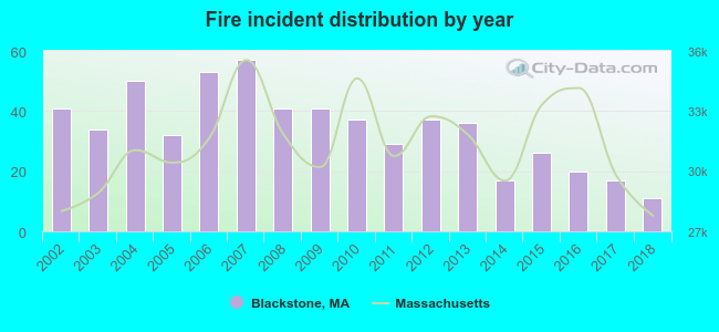 According to the data from the years 2002 - 2018 the average number of fire incidents per year is 34. The highest number of reported fires - 57 took place in 2007, and the least - 11 in 2018. The data has a declining trend.
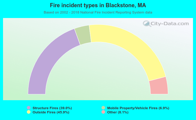 When looking into fire subcategories, the most reports belonged to: Outside Fires (45.9%), and Structure Fires (39.0%).
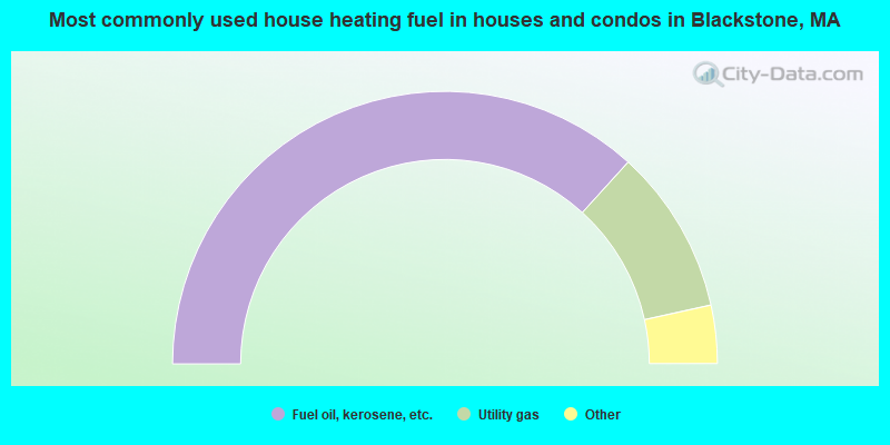
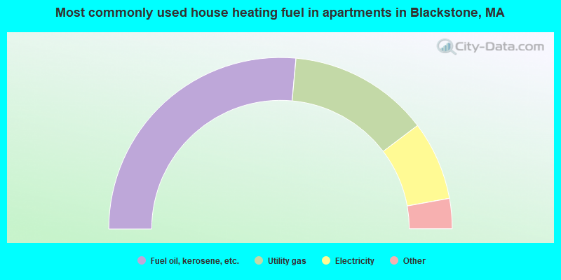
- 73.5%Fuel oil, kerosene, etc.
- 19.6%Utility gas
- 3.8%Electricity
- 1.7%Wood
- 1.4%Bottled, tank, or LP gas
- 52.9%Fuel oil, kerosene, etc.
- 26.5%Utility gas
- 14.9%Electricity
- 2.9%Bottled, tank, or LP gas
- 2.9%No fuel used
Blackstone compared to Massachusetts state average:
- Unemployed percentage significantly below state average.
- Black race population percentage significantly below state average.
- Hispanic race population percentage significantly below state average.
- Foreign-born population percentage significantly below state average.
- Length of stay since moving in significantly above state average.
- Number of rooms per house significantly below state average.
- House age significantly below state average.
- Percentage of population with a bachelor's degree or higher below state average.
Blackstone on our top lists:
- #6 on the list of "Top 101 cities with largest percentage of females in occupations: architects, surveyors, and cartographers (population 5,000+)"
- #19 on the list of "Top 101 cities with largest percentage of females in industries: pharmacies and drug stores (population 5,000+)"
- #20 on the list of "Top 101 cities with largest percentage of males in industries: gasoline stations (population 5,000+)"
- #28 on the list of "Top 101 cities with largest percentage of males in industries: water transportation (population 5,000+)"
- #29 on the list of "Top 101 cities with largest percentage of females in industries: other direct selling establishments (population 5,000+)"
- #29 on the list of "Top 101 cities with largest percentage of females in industries: plastics and rubber products (population 5,000+)"
- #31 on the list of "Top 101 cities with largest percentage of males in occupations: special education teachers (population 5,000+)"
- #32 on the list of "Top 101 cities with largest percentage of females in industries: professional and commercial equipment and supplies merchant wholesalers (population 5,000+)"
- #38 on the list of "Top 101 cities with largest percentage of females in occupations: financial clerks except bookkeeping, accounting, and auditing clerks (population 5,000+)"
- #41 on the list of "Top 101 cities with largest percentage of males in occupations: occupational and physical therapist assistants and aides (population 5,000+)"
- #41 on the list of "Top 101 cities with largest percentage of males in industries: nonmetallic mineral products (population 5,000+)"
- #44 on the list of "Top 101 cities with largest percentage of males in occupations: other transportation workers (population 5,000+)"
- #46 on the list of "Top 101 cities with largest percentage of males in occupations: material recording, scheduling, dispatching, and distributing workers (population 5,000+)"
- #46 on the list of "Top 101 cities with largest percentage of males in industries: professional and commercial equipment and supplies merchant wholesalers (population 5,000+)"
- #47 on the list of "Top 101 cities with largest percentage of females in industries: computer and electronic products (population 5,000+)"
- #47 on the list of "Top 101 cities with largest percentage of males in industries: pharmacies and drug stores (population 5,000+)"
- #47 on the list of "Top 101 cities with largest percentage of males in industries: drugs, sundries, and chemical and allied products merchant wholesalers (population 5,000+)"
- #49 on the list of "Top 101 cities with largest percentage of females in industries: health and personal care, except drug, stores (population 5,000+)"
- #58 on the list of "Top 101 cities with largest percentage of females in industries: paper and paper products merchant wholesalers (population 5,000+)"
- #59 on the list of "Top 101 cities with largest percentage of females in industries: building material and garden equipment and supplies dealers (population 5,000+)"
- #49 (01504) on the list of "Top 101 zip codes with the largest percentage of French Canadian first ancestries (pop 5,000+)"
- #4 on the list of "Top 101 counties with the highest carbon monoxide air pollution readings in 2012 (ppm)"
- #5 on the list of "Top 101 counties with the most Catholic congregations"
- #12 on the list of "Top 101 counties with the highest surface withdrawal of fresh water for public supply"
- #16 on the list of "Top 101 counties with the highest total withdrawal of fresh water for public supply"
- #23 on the list of "Top 101 counties with the highest Sulfur Oxides Annual air pollution readings in 2012 (µg/m3)"

|
|
Total of 132 patent applications in 2008-2024.