Bettie, Texas
Submit your own pictures of this place and show them to the world
- OSM Map
- General Map
- Google Map
- MSN Map

| Males: 1,726 | |
| Females: 1,748 |
| Median resident age: | 39.8 years |
| Texas median age: | 32.3 years |
Zip code: 75644
| Bettie: | $58,819 |
| TX: | $72,284 |
Estimated per capita income in 2022: $35,504 (it was $18,901 in 2000)
Bettie CCD income, earnings, and wages data
Estimated median house or condo value in 2022: $176,285 (it was $51,300 in 2000)
| Bettie: | $176,285 |
| TX: | $275,400 |
Detailed information about poverty and poor residents in Bettie, TX
Compare current foreclosures near Bettie, TX:
| Photo | Address | Area | Beds / Baths | Price | Details |
|---|---|---|---|---|---|

|
#1
Brooksy St
Gilmer, TX 75644
|
2,324 sq. feet
|
2 baths 4 beds |
$273,000
|
show details |

|
#2
S Montgomery St
Gilmer, TX 75644
|
1,038 sq. feet
|
1 baths 2 beds |
show details | |

|
#3
Caladium Rd
Ore City, TX 75683
|
880 sq. feet
|
1 baths - beds |
show details | |

|
#4
Elm Rd
Gilmer, TX 75645
|
912 sq. feet
|
2 baths - beds |
show details | |

|
#5
Black Gum Rd
Gilmer, TX 75644
|
2,467 sq. feet
|
2 baths - beds |
show details | |

|
#6
N Montgomery St
Gilmer, TX 75644
|
2,516 sq. feet
|
1 baths - beds |
show details | |

|
#7
Stuart St
Gilmer, TX 75644
|
1,564 sq. feet
|
1 baths - beds |
show details | |

|
#8
Private Road 3430
Gilmer, TX 75645
|
1,064 sq. feet
|
1 baths - beds |
show details | |

|
#9
Bluejay Ave
Gilmer, TX 75645
|
1,718 sq. feet
|
2 baths - beds |
show details | |

|
#10
Wild Onion Rd
Ore City, TX 75683
|
1,808 sq. feet
|
2 baths - beds |
show details |
| Photo | Address | Area | Beds / Baths | Price | Details |
|---|---|---|---|---|---|

|
#11
Fm 852
Gilmer, TX 75644
|
2,584 sq. feet
|
4 baths - beds |
show details | |

|
#12
Apricot Rd
Gilmer, TX 75644
|
1,843 sq. feet
|
2 baths - beds |
show details | |

|
#13
County Road 2606
Pittsburg, TX 75686
|
- sq. feet
|
- baths - beds |
show details | |

|
#14
Buckeye Rd
Gilmer, TX 75645
|
- sq. feet
|
- baths - beds |
show details | |

|
#15
Private Road 8652
Winnsboro, TX 75494
|
784 sq. feet
|
- baths - beds |
show details | |

|
#16
Fm 1520
Pittsburg, TX 75686
|
- sq. feet
|
- baths - beds |
show details | |

|
#17
Crabapple Rd
Gilmer, TX 75645
|
- sq. feet
|
- baths - beds |
show details | |

|
#18
Fm 555
Gilmer, TX 75645
|
- sq. feet
|
2 baths - beds |
show details | |

|
#19
Private Road 1150
Gilmer, TX 75645
|
- sq. feet
|
- baths - beds |
show details | |

|
#20
County Road 1353
Pittsburg, TX 75686
|
1,960 sq. feet
|
- baths - beds |
show details |
| Photo | Address | Area | Beds / Baths | Price | Details |
|---|---|---|---|---|---|

|
#21
S Montgomery St
Gilmer, TX 75644
|
- sq. feet
|
- baths - beds |
show details | |

|
#22
County Road 2208
Pittsburg, TX 75686
|
- sq. feet
|
- baths - beds |
show details | |

|
#23
Raccoon Rd
Pittsburg, TX 75686
|
- sq. feet
|
4 baths - beds |
show details | |

|
#24
County Road 3109
Pittsburg, TX 75686
|
- sq. feet
|
- baths - beds |
show details | |

|
#25
Gayla St
Pittsburg, TX 75686
|
1,470 sq. feet
|
- baths - beds |
show details | |

|
#26
Groundhog Rd
Gilmer, TX 75644
|
784 sq. feet
|
- baths - beds |
show details | |

|
#27
Pvt Rd 4124
Gilmer, TX 75644
|
- sq. feet
|
- baths - beds |
show details | |

|
#28
State Highway 155 N
Gilmer, TX 75644
|
- sq. feet
|
- baths - beds |
show details | |

|
#29
County Road 3322
Pittsburg, TX 75686
|
- sq. feet
|
- baths - beds |
show details | |

|
#30
Private Road 51321
Pittsburg, TX 75686
|
- sq. feet
|
- baths - beds |
show details |
| Photo | Address | Area | Beds / Baths | Price | Details |
|---|---|---|---|---|---|

|
#31
Farm To Market 1521
Pittsburg, TX 75686
|
- sq. feet
|
- baths - beds |
show details | |

|
Check over 1 million property listings on Foreclosure.com!
|
browse all offers | |||

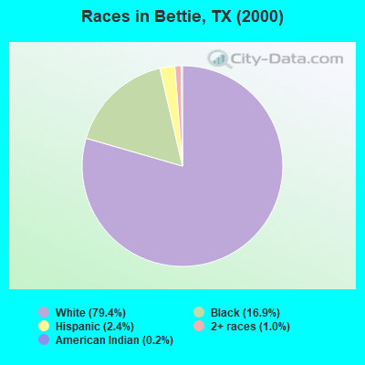
- 2,59979.4%White alone
- 55416.9%Black alone
- 772.4%Hispanic
- 341.0%Two or more races
- 70.2%American Indian alone
- 30.09%Other race alone
- 10.03%Asian alone
Races in Bettie detailed stats: ancestries, foreign born residents, place of birth
 Recent articles from our blog. Our writers, many of them Ph.D. graduates or candidates, create easy-to-read articles on a wide variety of topics.
Current Local Time: CST time zone
Land area: 141.4 square miles.
Population density: 25 people per square mile (very low).

| Bettie CCD: | 0.9% ($476) |
| Texas: | 1.8% ($1,393) |
Nearest city with pop. 50,000+: Longview, TX  (28.4 miles , pop. 73,344).
Nearest city with pop. 200,000+: Shreveport, LA (77.0 miles , pop. 200,145).
Nearest city with pop. 1,000,000+: Dallas, TX (103.4 miles , pop. 1,188,580).
Nearest cities:
), ), Latitude: 32.86 N, Longitude: 95.01 W
Area code: 903

| Here: | 3.9% |
| Texas: | 3.5% |
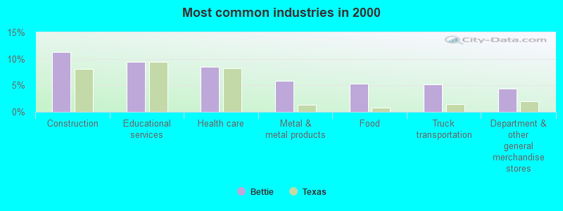
- Construction (11.3%)
- Educational services (9.5%)
- Health care (8.6%)
- Metal & metal products (5.8%)
- Food (5.3%)
- Truck transportation (5.2%)
- Department & other general merchandise stores (4.3%)
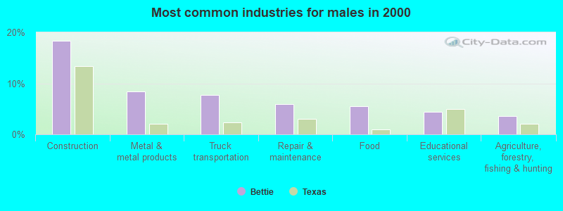
- Construction (18.4%)
- Metal & metal products (8.4%)
- Truck transportation (7.8%)
- Repair & maintenance (5.9%)
- Food (5.5%)
- Educational services (4.5%)
- Agriculture, forestry, fishing & hunting (3.6%)
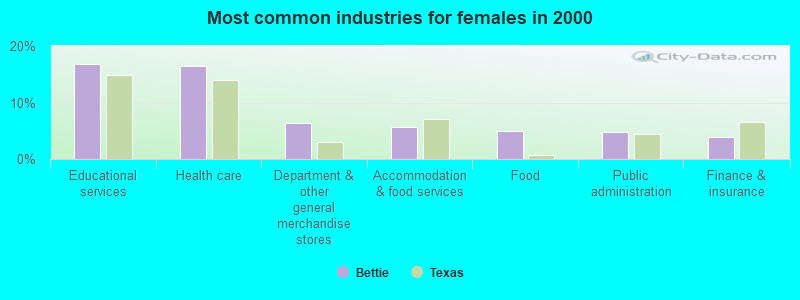
- Educational services (16.8%)
- Health care (16.4%)
- Department & other general merchandise stores (6.3%)
- Accommodation & food services (5.6%)
- Food (5.0%)
- Public administration (4.8%)
- Finance & insurance (3.9%)
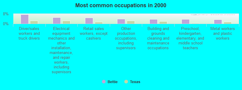
- Driver/sales workers and truck drivers (7.6%)
- Electrical equipment mechanics and other installation, maintenance, and repair workers, including supervisors (5.0%)
- Retail sales workers, except cashiers (4.8%)
- Other production occupations, including supervisors (3.9%)
- Building and grounds cleaning and maintenance occupations (3.7%)
- Preschool, kindergarten, elementary, and middle school teachers (3.7%)
- Metal workers and plastic workers (3.5%)
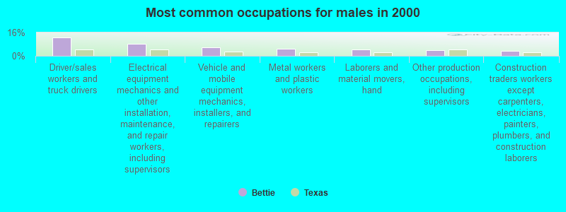
- Driver/sales workers and truck drivers (12.5%)
- Electrical equipment mechanics and other installation, maintenance, and repair workers, including supervisors (8.0%)
- Vehicle and mobile equipment mechanics, installers, and repairers (5.9%)
- Metal workers and plastic workers (4.8%)
- Laborers and material movers, hand (4.2%)
- Other production occupations, including supervisors (3.8%)
- Construction traders workers except carpenters, electricians, painters, plumbers, and construction laborers (3.4%)
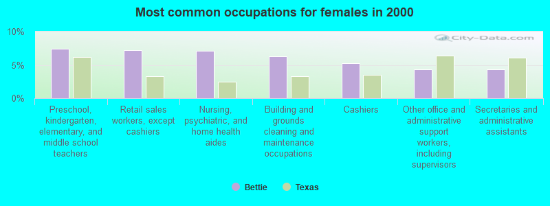
- Preschool, kindergarten, elementary, and middle school teachers (7.4%)
- Retail sales workers, except cashiers (7.3%)
- Nursing, psychiatric, and home health aides (7.1%)
- Building and grounds cleaning and maintenance occupations (6.3%)
- Cashiers (5.2%)
- Other office and administrative support workers, including supervisors (4.3%)
- Secretaries and administrative assistants (4.3%)
Average climate in Bettie, Texas
Based on data reported by over 4,000 weather stations


Tornado activity:
Bettie-area historical tornado activity is above Texas state average. It is 127% greater than the overall U.S. average.
On 4/1/1988, a category F3 (max. wind speeds 158-206 mph) tornado 12.9 miles away from the Bettie place center injured 9 people and caused between $500,000 and $5,000,000 in damages.
On 4/30/1954, a category F3 tornado 17.3 miles away from the place center injured one person and caused between $5000 and $50,000 in damages.
Earthquake activity:
Bettie-area historical earthquake activity is significantly above Texas state average. It is 431% greater than the overall U.S. average.On 11/6/2011 at 03:53:10, a magnitude 5.7 (5.7 MW, Depth: 3.2 mi, Class: Moderate, Intensity: VI - VII) earthquake occurred 210.4 miles away from Bettie center
On 9/3/2016 at 12:02:44, a magnitude 5.8 (5.8 MW, Depth: 3.5 mi) earthquake occurred 269.7 miles away from Bettie center
On 5/17/2012 at 08:12:00, a magnitude 4.8 (4.8 MW, Depth: 3.1 mi, Class: Light, Intensity: IV - V) earthquake occurred 74.6 miles away from Bettie center
On 9/2/2013 at 23:51:15, a magnitude 4.3 (4.3 MW, Depth: 2.9 mi) earthquake occurred 74.0 miles away from Bettie center
On 9/2/2013 at 21:52:38, a magnitude 4.2 (4.2 MW, Depth: 3.0 mi) earthquake occurred 68.0 miles away from the city center
On 11/7/2016 at 01:44:24, a magnitude 5.0 (5.0 MW, Depth: 2.8 mi) earthquake occurred 239.5 miles away from Bettie center
Magnitude types: moment magnitude (MW)
Natural disasters:
The number of natural disasters in Upshur County (17) is near the US average (15).Major Disasters (Presidential) Declared: 10
Emergencies Declared: 6
Causes of natural disasters: Storms: 6, Floods: 5, Fires: 4, Hurricanes: 4, Tornadoes: 3, Winter Storm: 1, Other: 2 (Note: some incidents may be assigned to more than one category).
Hospitals and medical centers near Bettie:
- LEISURE LODGE (Nursing Home, about 9 miles away; GILMER, TX)
- REHABILITATION AND HEALTHC (Nursing Home, about 9 miles away; GILMER, TX)
- BAYLOR CARE CENTER AT GILMER (Nursing Home, about 10 miles away; GILMER, TX)
- GILMER CARE CENTER (Nursing Home, about 10 miles away; GILMER, TX)
- EAST TEXAS MEDICAL CENTER - GILMER Acute Care Hospitals (about 10 miles away; GILMER, TX)
- GILMER DIALYSIS (Dialysis Facility, about 10 miles away; GILMER, TX)
- EAST TEXAS MEDICAL CENTER HOME HEALTH NORTH (Home Health Center, about 10 miles away; PITTSBURG, TX)
Colleges/universities with over 2000 students nearest to Bettie:
- Northeast Texas Community College (about 19 miles; Mount Pleasant, TX; Full-time enrollment: 2,320)
- LeTourneau University (about 32 miles; Longview, TX; FT enrollment: 2,357)
- Kilgore College (about 35 miles; Kilgore, TX; FT enrollment: 3,127)
- Tyler Junior College (about 40 miles; Tyler, TX; FT enrollment: 8,104)
- The University of Texas at Tyler (about 41 miles; Tyler, TX; FT enrollment: 5,774)
- Texas A & M University-Commerce (about 59 miles; Commerce, TX; FT enrollment: 8,890)
- Paris Junior College (about 63 miles; Paris, TX; FT enrollment: 3,875)
Points of interest:
Notable locations in Bettie: Camp Gilmont (A), Gilmont Lookout (B), Smith Siding (C), Soules Chapel (D), Union Ridge Community Center (E), Lafayette Volunteer Fire Department (F), Ewell Volunteer Fire Department (G). Display/hide their locations on the map
Churches in Bettie include: Saint Merner Church (A), Union Ridge Church (B), Valley Spring Church (C), Wallace Chapel (D), Willow Oak Church (E), Youngs Chapel (F), Zion Hill Church (G), Antioch Church (H), Concord Missionary Church (I). Display/hide their locations on the map
Cemeteries: Lone Mountain Cemetery (1), Zion Hill Cemetery (2), Grice Cemetery (3), Christian Hope Cemetery (4), Crossroad Cemetery (5), Pleasant Grove Cemetery (6), Simpsonville Cemetery (7). Display/hide their locations on the map
Lakes and reservoirs: Grassy Lake (A), Lilly Lake (B), Russell Lake (C), Machen Lake (D), Ewell Lake (E), Elwood Club Lake (F), Bishop Lake (G), Harris Lake (H). Display/hide their locations on the map
Streams, rivers, and creeks: Spratt Creek (A), Prairie Creek (B), Poor Creek (C), Olive Branch (D), Duffy Branch (E), Duke Branch (F), Enon Branch (G), Hadenfield Branch (H), Hamberlin Branch (I). Display/hide their locations on the map
| This place: | 2.5 people |
| Texas: | 2.8 people |
| This place: | 73.5% |
| Whole state: | 69.9% |
| This place: | 3.4% |
| Whole state: | 6.0% |
Likely homosexual households (counted as self-reported same-sex unmarried-partner households)
- Lesbian couples: 0.3% of all households
- Gay men: 0.2% of all households
| This place: | 14.5% |
| Whole state: | 15.4% |
| This place: | 8.8% |
| Whole state: | 6.7% |
For population 15 years and over in Bettie:
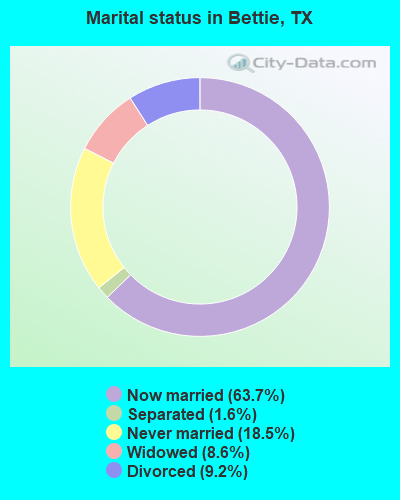
- Never married: 18.5%
- Now married: 63.7%
- Separated: 1.6%
- Widowed: 8.6%
- Divorced: 9.2%
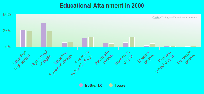
For population 25 years and over in Bettie:
- High school or higher: 73.6%
- Bachelor's degree or higher: 10.1%
- Graduate or professional degree: 3.2%
- Unemployed: 4.6%
- Mean travel time to work (commute): 29.8 minutes
| Here: | 11.0 |
| Texas average: | 15.6 |

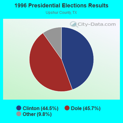
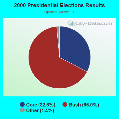

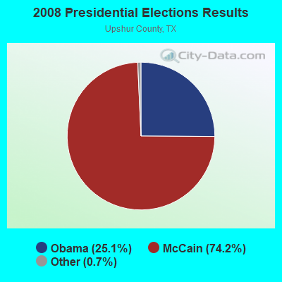
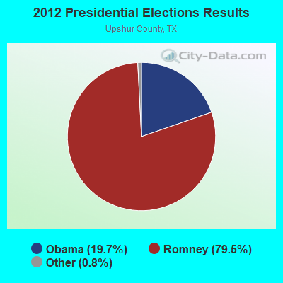
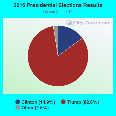
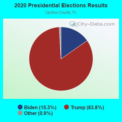
Graphs represent county-level data. Detailed 2008 Election Results
Religion statistics for Bettie, TX (based on Upshur County data)
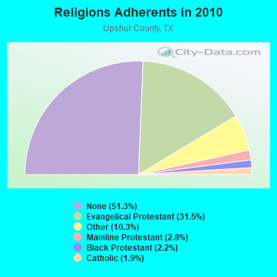
| Religion | Adherents | Congregations |
|---|---|---|
| Evangelical Protestant | 12,377 | 60 |
| Other | 4,047 | 7 |
| Mainline Protestant | 1,091 | 8 |
| Black Protestant | 876 | 6 |
| Catholic | 743 | 2 |
| None | 20,175 | - |
Food Environment Statistics:
| This county: | 0.79 / 10,000 pop. |
| State: | 1.47 / 10,000 pop. |
| Here: | 0.26 / 10,000 pop. |
| Texas: | 0.14 / 10,000 pop. |
| Upshur County: | 0.79 / 10,000 pop. |
| Texas: | 1.11 / 10,000 pop. |
| This county: | 4.49 / 10,000 pop. |
| Texas: | 3.95 / 10,000 pop. |
| Upshur County: | 3.70 / 10,000 pop. |
| State: | 6.13 / 10,000 pop. |
| Upshur County: | 9.8% |
| State: | 8.9% |
| This county: | 28.3% |
| Texas: | 26.6% |
| Upshur County: | 14.6% |
| Texas: | 15.7% |
Strongest AM radio stations in Bettie:
- KEEL (710 AM; 50 kW; SHREVEPORT, LA; Owner: CITICASTERS LICENSES, L.P.)
- KWKH (1130 AM; 50 kW; SHREVEPORT, LA; Owner: CITICASTERS LICENSES, L.P.)
- KOFY (1060 AM; daytime; 10 kW; GILMER, TX; Owner: JERRY RUSSELL D/B/A THE RUSSELL COMPANY)
- KFXR (1190 AM; 50 kW; DALLAS, TX; Owner: CLEAR CHANNEL BROADCASTING LICENSES, INC.)
- KEES (1430 AM; 5 kW; GLADEWATER, TX; Owner: CITADEL BROADCASTING COMPANY)
- KRLD (1080 AM; 50 kW; DALLAS, TX; Owner: TEXAS INFINITY BROADCASTING L.P.)
- KTBB (600 AM; 5 kW; TYLER, TX; Owner: CITADEL BROADCASTING COMPANY)
- KPYN (900 AM; 10 kW; ATLANTA, TX; Owner: FAMILY WORSHIP CENTER CHURCH, INC.)
- WBAP (820 AM; 50 kW; FORT WORTH, TX; Owner: WBAP-KSCS OPERATING, LTD.)
- KSKY (660 AM; 20 kW; BALCH SPRINGS, TX; Owner: BISON MEDIA, INC.)
- KZMP (1540 AM; 50 kW; UNIVERSITY PARK, TX; Owner: ENTRAVISION HOLDINGS, LLC)
- KESS (1270 AM; 50 kW; FORT WORTH, TX; Owner: KESS-AM LICENSE CORP.)
- KIMP (960 AM; 1 kW; MOUNT PLEASANT, TX; Owner: EAST TEXAS BROADCASTING, INC.)
Strongest FM radio stations in Bettie:
- KYKX (105.7 FM; LONGVIEW, TX; Owner: WALLER MEDIA, LLC)
- KDVE (103.1 FM; PITTSBURG, TX; Owner: ON-AIR FAMILY, LLC)
- KFRO-FM (95.3 FM; GILMER, TX; Owner: WALLER MEDIA, LLC)
- KSCN (96.9 FM; PITTSBURG, TX; Owner: EAST TEXAS BROADCASTING, INC.)
- KVNE (89.5 FM; TYLER, TX; Owner: EDUC. RADIO FOUND. OF E. TEXAS, INC.)
- KWNS (104.7 FM; WINNSBORO, TX; Owner: RICHARD E. FOSTER)
- KTAA (90.7 FM; BIG SANDY, TX; Owner: INSTITUTE IN BASIC LIFE PRINCIPLES, INC.)
- KAZE (106.9 FM; ORE CITY, TX; Owner: REYNOLDS RADIO, INC.)
- KNUE (101.5 FM; TYLER, TX; Owner: CAPSTAR TX LIMITED PARTNERSHIP)
- KIXK (99.3 FM; WHITE OAK, TX; Owner: REYNOLDS RADIO, INC.)
- KALK (97.7 FM; WINFIELD, TX; Owner: EAST TEXAS BROADCASTING, INC.)
- KKTX-FM (96.1 FM; KILGORE, TX; Owner: CAPSTAR TX LIMITED PARTNERSHIP)
TV broadcast stations around Bettie:
- KLTV (Channel 7; TYLER, TX; Owner: CIVCO, INC.)
- KFXK (Channel 51; LONGVIEW, TX; Owner: WARWICK COMMUNICATIONS, INC.)
- KTAL-TV (Channel 6; TEXARKANA, TX; Owner: NEXSTAR BROADCASTING OF LOUISIANA, LLC)
- KLPN-LP (Channel 58; LONGVIEW, TX; Owner: WARWICK COMMUNICATIONS, INC.)
- K54CB (Channel 54; MOUNT PLEASANT, TX; Owner: F. V. P. NETWORK, INC)
FCC Registered Microwave Towers:
1- Hwy 271 3 Mi N Of (Lat: 32.837611 Lon: -94.951861), Structure height: 4.3 m, Overall height: 10.4 m, Call Sign: WPJA539,
Assigned Frequencies: 952.081 MHz, 928.081 MHz, Grant Date: 08/11/2000, Expiration Date: 09/07/2010, Cancellation Date: 11/13/2010, Phone: (512) 908-4300
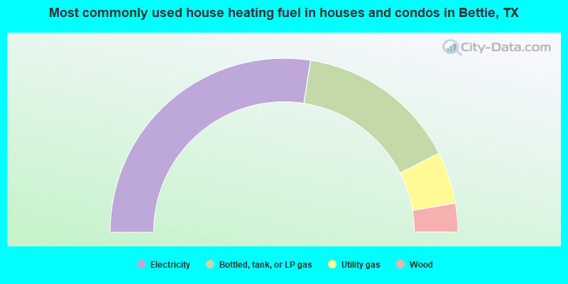
- 54.9%Electricity
- 30.1%Bottled, tank, or LP gas
- 9.7%Utility gas
- 5.3%Wood
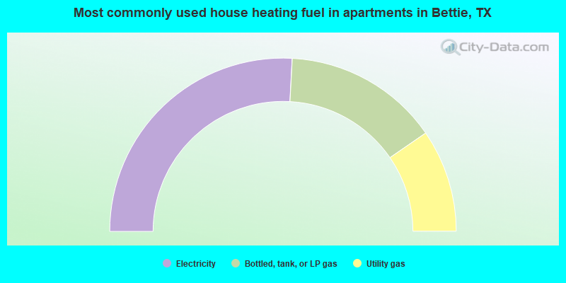
- 51.7%Electricity
- 29.1%Bottled, tank, or LP gas
- 19.2%Utility gas
Bettie compared to Texas state average:
- Median house value below state average.
- Unemployed percentage significantly below state average.
- Hispanic race population percentage significantly below state average.
- Median age significantly above state average.
- Foreign-born population percentage significantly below state average.
- Renting percentage significantly below state average.
- Length of stay since moving in significantly above state average.
- Number of rooms per house significantly below state average.
- House age significantly below state average.
- Number of college students below state average.
- Percentage of population with a bachelor's degree or higher below state average.