Bethel, Maine

Submit your own pictures of this town and show them to the world
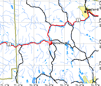
- OSM Map
- General Map
- Google Map
- MSN Map
Population change since 2000: +8.1%
 |
| Males: 1,251 | |
| Females: 1,356 |
| Median resident age: | 42.9 years |
| Maine median age: | 43.0 years |
Zip codes: 04217.
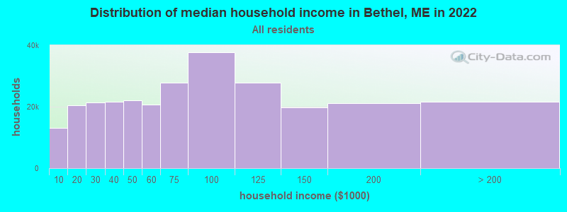
| Bethel: | $56,431 |
| ME: | $69,543 |
Estimated per capita income in 2022: $32,997 (it was $17,458 in 2000)
Bethel town income, earnings, and wages data
Estimated median house or condo value in 2022: $272,867 (it was $104,400 in 2000)
| Bethel: | $272,867 |
| ME: | $290,600 |
Mean prices in 2022: all housing units: $258,607; detached houses: $254,021; townhouses or other attached units: $393,466; in 2-unit structures: $184,786; in 3-to-4-unit structures: $229,715; in 5-or-more-unit structures: $205,553; mobile homes: $333,480; occupied boats, rvs, vans, etc.: $32,243
Detailed information about poverty and poor residents in Bethel, ME


- 2,52096.7%White alone
- 321.2%Hispanic
- 210.8%Two or more races
- 140.5%Black alone
- 130.5%Asian alone
- 50.2%American Indian alone
- 20.08%Other race alone
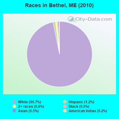
Races in Bethel detailed stats: ancestries, foreign born residents, place of birth
According to our research of Maine and other state lists, there were 2 registered sex offenders living in Bethel, Maine as of May 08, 2024.
The ratio of all residents to sex offenders in Bethel is 1,304 to 1.
The ratio of registered sex offenders to all residents in this city is much lower than the state average.
 Recent articles from our blog. Our writers, many of them Ph.D. graduates or candidates, create easy-to-read articles on a wide variety of topics.

 | Bethel Maine Fisherman Lands a 50-inch Striped Bass (2 replies) |
| Ticks and bugs in Bethel area? (20 replies) |
| Bethel Maine - Things to do? (13 replies) |
| Visiting Bethel (1 reply) |
| Maine weather thread (3207 replies) |
| Move from Alaska to Maine? (90 replies) |
Latest news from Bethel, ME collected exclusively by city-data.com from local newspapers, TV, and radio stations
Bethel, ME City Guides:
Ancestries: English (31.1%), Irish (13.4%), United States (10.2%), French (9.8%), German (9.0%), Scottish (6.0%).
Current Local Time: EST time zone
Incorporated on 06/10/1796
Elevation: 665 feet
Land area: 64.8 square miles.
Population density: 40 people per square mile (very low).
41 residents are foreign born
| This town: | 1.7% |
| Maine: | 2.9% |
| Bethel town: | 1.0% ($1,089) |
| Maine: | 1.5% ($1,417) |
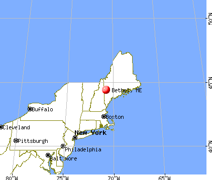
Nearest city with pop. 50,000+: Portland, ME  (57.7 miles , pop. 64,249).
Nearest city with pop. 200,000+: Boston, MA (145.4 miles , pop. 589,141).
Nearest city with pop. 1,000,000+: Bronx, NY (292.4 miles , pop. 1,332,650).
Nearest cities:
), ), )Latitude: 44.41 N, Longitude: 70.78 W
Area code: 207

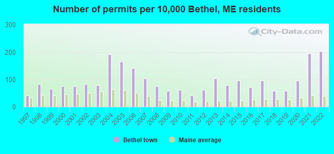
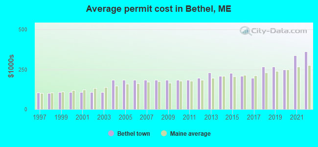
Single-family new house construction building permits:
- 2022: 49 buildings, average cost: $363,800
- 2021: 47 buildings, average cost: $337,600
- 2020: 23 buildings, average cost: $248,200
- 2019: 14 buildings, average cost: $267,100
- 2018: 14 buildings, average cost: $267,100
- 2017: 23 buildings, average cost: $196,900
- 2016: 17 buildings, average cost: $210,100
- 2015: 23 buildings, average cost: $227,800
- 2014: 19 buildings, average cost: $208,900
- 2013: 25 buildings, average cost: $231,200
- 2012: 15 buildings, average cost: $197,900
- 2011: 10 buildings, average cost: $183,700
- 2010: 15 buildings, average cost: $183,700
- 2009: 14 buildings, average cost: $183,700
- 2008: 18 buildings, average cost: $183,700
- 2007: 25 buildings, average cost: $183,700
- 2006: 34 buildings, average cost: $183,700
- 2005: 40 buildings, average cost: $183,700
- 2004: 46 buildings, average cost: $183,700
- 2003: 19 buildings, average cost: $107,300
- 2002: 20 buildings, average cost: $107,300
- 2001: 18 buildings, average cost: $107,300
- 2000: 18 buildings, average cost: $107,200
- 1999: 16 buildings, average cost: $108,300
- 1998: 20 buildings, average cost: $101,700
- 1997: 10 buildings, average cost: $106,200
| Here: | 3.0% |
| Maine: | 3.4% |

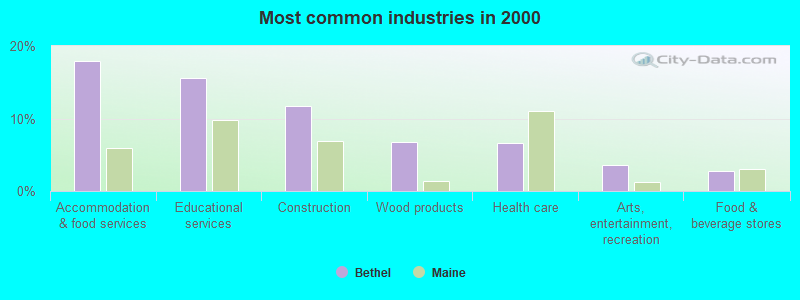
- Accommodation & food services (17.9%)
- Educational services (15.6%)
- Construction (11.7%)
- Wood products (6.8%)
- Health care (6.6%)
- Arts, entertainment, recreation (3.5%)
- Food & beverage stores (2.7%)
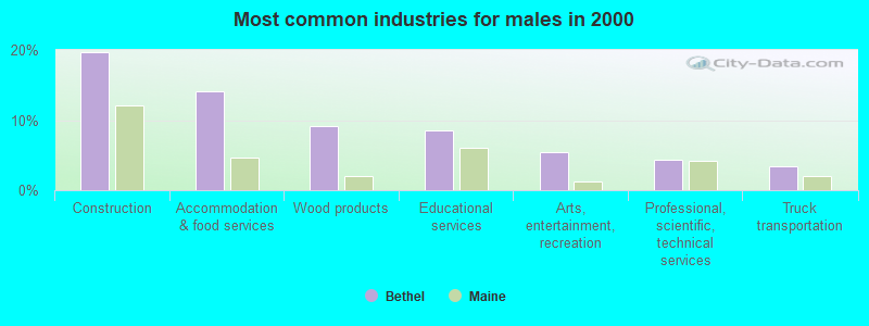
- Construction (19.7%)
- Accommodation & food services (14.2%)
- Wood products (9.1%)
- Educational services (8.5%)
- Arts, entertainment, recreation (5.4%)
- Professional, scientific, technical services (4.3%)
- Truck transportation (3.5%)

- Educational services (23.9%)
- Accommodation & food services (22.4%)
- Health care (11.1%)
- Social assistance (4.8%)
- Wood products (4.1%)
- Food & beverage stores (3.9%)
- Finance & insurance (3.8%)

- Preschool, kindergarten, elementary, and middle school teachers (5.5%)
- Other sales and related occupations, including supervisors (4.7%)
- Other management occupations, except farmers and farm managers (4.5%)
- Building and grounds cleaning and maintenance occupations (3.6%)
- Cooks and food preparation workers (3.6%)
- Other production occupations, including supervisors (3.6%)
- Carpenters (3.2%)
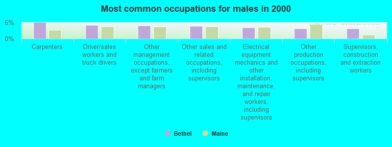
- Carpenters (5.9%)
- Driver/sales workers and truck drivers (5.1%)
- Other management occupations, except farmers and farm managers (4.9%)
- Other sales and related occupations, including supervisors (4.8%)
- Electrical equipment mechanics and other installation, maintenance, and repair workers, including supervisors (4.2%)
- Other production occupations, including supervisors (3.9%)
- Supervisors, construction and extraction workers (3.8%)

- Preschool, kindergarten, elementary, and middle school teachers (8.5%)
- Cashiers (5.6%)
- Other sales and related occupations, including supervisors (4.6%)
- Building and grounds cleaning and maintenance occupations (4.6%)
- Child care workers (4.3%)
- Cooks and food preparation workers (4.3%)
- Other teachers, instructors, education, training, and library occupations (4.1%)
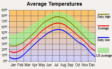
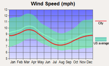
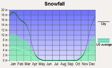
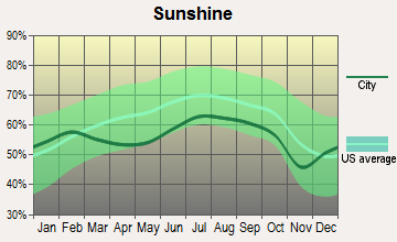
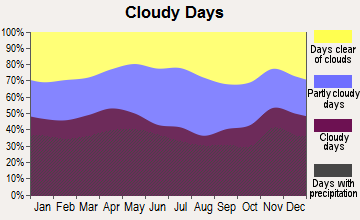
Average climate in Bethel, Maine
Based on data reported by over 4,000 weather stations
(lower is better)
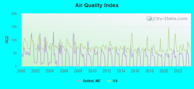
Air Quality Index (AQI) level in 2022 was 45.0. This is significantly better than average.
| City: | 45.0 |
| U.S.: | 72.6 |
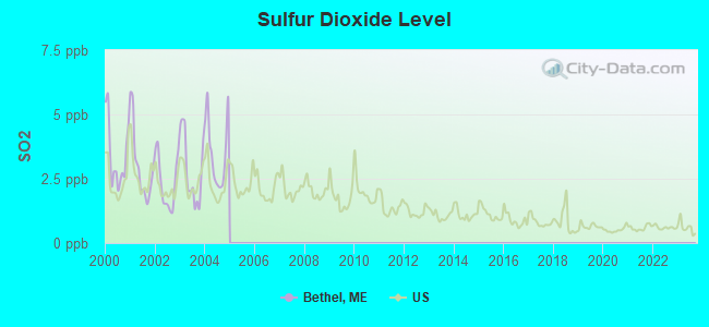
Sulfur Dioxide (SO2) [ppb] level in 2004 was 3.52. This is significantly worse than average. Closest monitor was 14.9 miles away from the city center.
| City: | 3.52 |
| U.S.: | 1.51 |
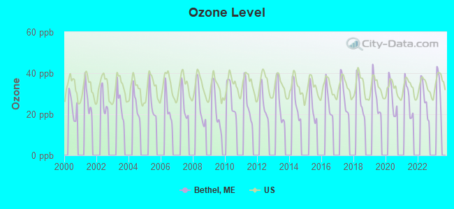
Ozone [ppb] level in 2022 was 27.7. This is better than average. Closest monitor was 11.8 miles away from the city center.
| City: | 27.7 |
| U.S.: | 33.3 |
Earthquake activity:
Bethel-area historical earthquake activity is significantly above Maine state average. It is 74% smaller than the overall U.S. average.On 4/20/2002 at 10:50:47, a magnitude 5.3 (5.3 ML, Depth: 3.0 mi, Class: Moderate, Intensity: VI - VII) earthquake occurred 144.0 miles away from Bethel center
On 4/20/2002 at 10:50:47, a magnitude 5.2 (5.2 MB, 4.2 MS, 5.2 MW, 5.0 MW) earthquake occurred 144.9 miles away from the city center
On 10/7/1983 at 10:18:46, a magnitude 5.3 (5.1 MB, 5.3 LG, 5.1 ML) earthquake occurred 179.3 miles away from Bethel center
On 10/16/2012 at 23:12:25, a magnitude 4.7 (4.7 ML, Depth: 10.0 mi, Class: Light, Intensity: IV - V) earthquake occurred 56.7 miles away from Bethel center
On 1/19/1982 at 00:14:42, a magnitude 4.7 (4.5 MB, 4.7 MD, 4.5 LG) earthquake occurred 75.0 miles away from Bethel center
On 8/21/1996 at 07:54:14, a magnitude 3.8 (3.8 LG, 3.6 LG, Depth: 6.2 mi, Class: Light, Intensity: II - III) earthquake occurred 32.2 miles away from Bethel center
Magnitude types: regional Lg-wave magnitude (LG), body-wave magnitude (MB), duration magnitude (MD), local magnitude (ML), surface-wave magnitude (MS), moment magnitude (MW)
Natural disasters:
The number of natural disasters in Oxford County (31) is a lot greater than the US average (15).Major Disasters (Presidential) Declared: 23
Emergencies Declared: 7
Causes of natural disasters: Floods: 19, Storms: 16, Snows: 7, Hurricanes: 3, Heavy Rains: 2, Blizzard: 1, Ice Storm: 1, Landslide: 1, Mudslide: 1, Snowfall: 1, Tropical Storm: 1, Wind: 1, Winter Storm: 1, Other: 2 (Note: some incidents may be assigned to more than one category).
Main business address for: AMERICAN SKIING CO /ME (SERVICES-MISCELLANEOUS AMUSEMENT & RECREATION).
Airports located in Bethel:
- Bethel Regional Airport (0B1) (Runways: 1, Itinerant Ops: 2,000, Local Ops: 2,500, Military Ops: 20)
Colleges/universities with over 2000 students nearest to Bethel:
- University of Maine at Farmington (about 37 miles; Farmington, ME; Full-time enrollment: 2,036)
- Saint Joseph's College of Maine (about 44 miles; Standish, ME; FT enrollment: 2,010)
- University of Maine at Augusta (about 50 miles; Augusta, ME; FT enrollment: 3,204)
- University of Southern Maine (about 58 miles; Portland, ME; FT enrollment: 6,647)
- Southern Maine Community College (about 60 miles; South Portland, ME; FT enrollment: 4,666)
- Plymouth State University (about 64 miles; Plymouth, NH; FT enrollment: 4,838)
- University of New England (about 69 miles; Biddeford, ME; FT enrollment: 4,539)
Public high school in Bethel:
- TELSTAR HIGH SCHOOL (Location: 284 WALKERS MILLS ROAD, Grades: 9-12)
Public elementary/middle schools in Bethel:
- CRESCENT PARK SCHOOL (Students: 296, Location: 19 CRESCENT LANE, Grades: KG-5)
- TELSTAR MIDDLE SCHOOL (Location: 284 WALKERS MILLS ROAD, Grades: 6-8)
Points of interest:
Notable locations in Bethel: Carters Cross Country Ski Center (A), Evans Notch District Ranger Station (B), Bethel Outdoor Adventures Campground (C), Bethel Rescue Station (D), O'Neil Robinson House (E), Moses Mason House Museum (F), Bethel Historical Society Regional History Museum (G), Bethel Historical Society (H), Bethel Fire Department (I). Display/hide their locations on the map
Main business address in Bethel: AMERICAN SKIING CO /ME (A). Display/hide its location on the map
Churches in Bethel include: Our Lady of the Snows Church (A), West Bethel Union Church (B), United Methodist Church (C), Congregational Church (D), Bethel Church of the Nazarene (E). Display/hide their locations on the map
Cemeteries: Bartlett Cemetery (1), Birds Hill Cemetery (2), Chandler Hill Cemetery (3), Flat Cemetery (4), Mount Will Cemetery (5), Riverside Cemetery (6), Skillingston Cemetery (7). Display/hide their locations on the map
Streams, rivers, and creeks: Mill Brook (A), Sunday River (B), Twitchell Brook (C), Pleasant River (D), Lanes Brook (E), Kendall Brook (F), Otter Brook (G), Chapman Brook (H), Chandler Brook (I). Display/hide their locations on the map
Park in Bethel: Broad Street Historic District (1). Display/hide its location on the map
Hotels: Snow Cap Inn (Sunday River Ski Resort) (1), Brookside Condominiums (Sunday River Ski Resort) (2), Jordan Grand Resort Hotel (Sunday River Ski Resort) (3), Bethel Spa Motel (88 Main Street) (4), Norseman Inn (134 Mayville Road) (5), Holidae House (85 Main Street) (6), White Cap Condominiums (Sunday River Ski Resort) (7), Sunday River Ski Resort - Snow Cap Inn (1 Sunday River Road) (8), Briar-Lea Inn & Restaurant (150 Mayville Road) (9). Display/hide their approximate locations on the map
Birthplace of: La Fayette Grover - Politician, Cuvier Grover - Union Army general, Henry J. Bean - Politician.
Drinking water stations with addresses in Bethel and their reported violations in the past:
PHOENIX HOUSE & WELL (Population served: 900, Groundwater):Past monitoring violations:TWO BROTHERS (Population served: 198, Groundwater):
- 10 routine major monitoring violations
Past monitoring violations:INMANS DINER AND DAIRY BAR (Population served: 150, Groundwater):
- 28 routine major monitoring violations
- One regular monitoring violation
Past monitoring violations:MSAD 44 WOODSTOCK ELEM SCHOOL (Population served: 105, Groundwater):
- 2 routine major monitoring violations
Past monitoring violations:CHAMBERLAIN CONDOMINIUM ASSOC (Population served: 72, Groundwater):
- Monitoring and Reporting (DBP) - Between JAN-2008 and DEC-2010, Contaminant: Total Haloacetic Acids (HAA5). Follow-up actions: St Public Notif requested (DEC-08-2010), St Formal NOV issued (DEC-08-2010), St Public Notif received (MAR-27-2012), St Compliance achieved (SEP-06-2012)
- Monitoring and Reporting (DBP) - Between JAN-2008 and DEC-2010, Contaminant: TTHM. Follow-up actions: St Public Notif requested (DEC-08-2010), St Formal NOV issued (DEC-08-2010), St Public Notif received (MAR-27-2012), St Compliance achieved (SEP-06-2012)
- One routine major monitoring violation
- One regular monitoring violation
Past health violations:RIVER VIEW RESORT (Population served: 64, Groundwater):Past monitoring violations:
- MCL, Monthly (TCR) - In SEP-2013, Contaminant: Coliform. Follow-up actions: St Public Notif requested (SEP-19-2013), St Formal NOV issued (SEP-19-2013), St Public Notif received (OCT-08-2013), St Compliance achieved (OCT-15-2013)
- MCL, Monthly (TCR) - In JAN-2012, Contaminant: Coliform. Follow-up actions: St Public Notif requested (FEB-06-2012), St Formal NOV issued (FEB-06-2012), St Public Notif received (FEB-14-2012), St Compliance achieved (FEB-27-2012)
- One routine major monitoring violation
Past health violations:BARKING DAWG MARKET LLC (Population served: 36, Groundwater):Past monitoring violations:
- MCL, Monthly (TCR) - In OCT-2005, Contaminant: Coliform. Follow-up actions: St Public Notif requested (NOV-07-2005), St Violation/Reminder Notice (NOV-07-2005), St Public Notif received (JAN-06-2006), St Compliance achieved (JAN-06-2006), St Public Notif received (JAN-06-2006), St Compliance achieved (JUN-14-2006)
- MCL, Monthly (TCR) - In JUN-2005, Contaminant: Coliform. Follow-up actions: St Public Notif requested (JUL-11-2005), St Violation/Reminder Notice (JUL-11-2005), St Compliance achieved (DEC-08-2005), St Public Notif received (2 times from JAN-06-2006 to JAN-06-2006)
- Monitoring, Repeat Major (TCR) - In NOV-2005, Contaminant: Coliform (TCR). Follow-up actions: St Public Notif requested (DEC-20-2005), St Violation/Reminder Notice (DEC-20-2005), St Public Notif received (JAN-06-2006), St Compliance achieved (JAN-06-2006), St Public Notif received (JAN-06-2006), St Compliance achieved (JUN-14-2006)
- 5 routine major monitoring violations
- One regular monitoring violation
Past health violations:MOOSES TALE FOOD & ALE (Population served: 30, Groundwater):Past monitoring violations:
- MCL, Monthly (TCR) - In JUL-2005, Contaminant: Coliform. Follow-up actions: St Public Notif requested (JUL-29-2005), St Violation/Reminder Notice (JUL-29-2005), St Public Notif received (2 times from NOV-16-2005 to NOV-16-2005), St Compliance achieved (SEP-10-2007)
- MCL, Monthly (TCR) - In MAY-2005, Contaminant: Coliform. Follow-up actions: St Public Notif requested (JUN-20-2005), St Violation/Reminder Notice (JUN-20-2005), St Compliance achieved (SEP-10-2007), St Intentional no-action (AUG-14-2011)
- 3 routine major monitoring violations
Past health violations:Past monitoring violations:
- MCL, Monthly (TCR) - In JUN-2009, Contaminant: Coliform. Follow-up actions: St Public Notif requested (JUL-23-2009), St Formal NOV issued (JUL-23-2009), St Public Notif received (AUG-06-2009), St Compliance achieved (JUN-30-2010)
- MCL, Monthly (TCR) - Between APR-2009 and JUN-2009, Contaminant: Coliform. Follow-up actions: St Public Notif requested (MAY-29-2009), St Formal NOV issued (MAY-29-2009), St Public Notif received (AUG-10-2009), St Compliance achieved (JUN-30-2010)
- One regular monitoring violation
Drinking water stations with addresses in Bethel that have no violations reported:
- BETHEL WATER DISTRICT (Population served: 1,575, Primary Water Source Type: Groundwater)
- RIVERBEND CONDOMINIUMS (Population served: 90, Primary Water Source Type: Groundwater)
- POWDER RIDGE TOWNHOMES (Population served: 40, Primary Water Source Type: Groundwater)
- GRAFTON NOTCH CAMPGROUND (Population served: 35, Primary Water Source Type: Groundwater)
| This town: | 2.3 people |
| Maine: | 2.3 people |
| This town: | 63.1% |
| Whole state: | 62.9% |
| This town: | 10.1% |
| Whole state: | 9.4% |
Likely homosexual households (counted as self-reported same-sex unmarried-partner households)
- Lesbian couples: 0.4% of all households
- Gay men: 0.4% of all households
| This town: | 10.2% |
| Whole state: | 10.9% |
| This town: | 3.3% |
| Whole state: | 4.1% |
Banks with branches in Bethel (2011 data):
- KeyBank National Association: Bethel Branch at 96 Main Street, branch established on 1945/11/17. Info updated 2008/03/03: Bank assets: $86,198.8 mil, Deposits: $64,214.8 mil, headquarters in Cleveland, OH, positive income, Commercial Lending Specialization, 1067 total offices, Holding Company: Keycorp
- Northeast Bank: Bethel Branch at 11 Main Street, branch established on 1997/07/01. Info updated 2006/11/03: Bank assets: $587.1 mil, Deposits: $401.6 mil, headquarters in Lewiston, ME, positive income, Commercial Lending Specialization, 11 total offices, Holding Company: Northeast Bancorp
- Norway Savings Bank: Bethel Branch at One Parkway Road, branch established on 1996/12/19. Info updated 2006/11/03: Bank assets: $958.8 mil, Deposits: $711.3 mil, headquarters in Norway, ME, positive income, Commercial Lending Specialization, 20 total offices, Holding Company: Norway Bancorp, Mhc
For population 15 years and over in Bethel:
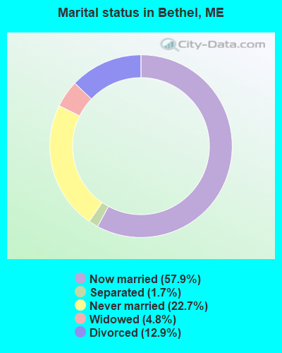
- Never married: 22.7%
- Now married: 57.9%
- Separated: 1.7%
- Widowed: 4.8%
- Divorced: 12.9%
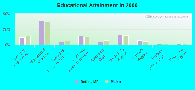
For population 25 years and over in Bethel:
- High school or higher: 88.0%
- Bachelor's degree or higher: 25.2%
- Graduate or professional degree: 9.7%
- Unemployed: 4.1%
- Mean travel time to work (commute): 20.5 minutes
| Here: | 10.7 |
| Maine average: | 11.2 |
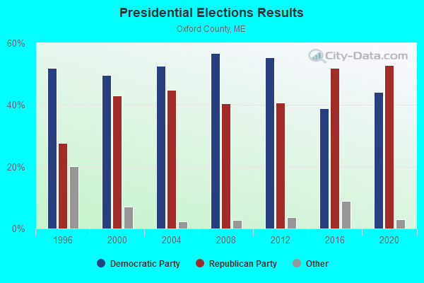
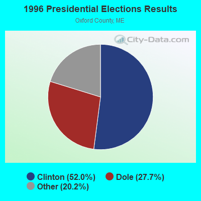
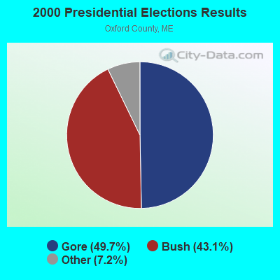
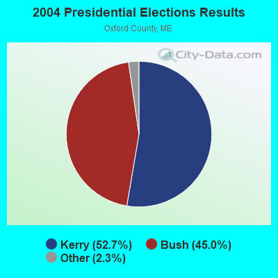


Graphs represent county-level data. Detailed 2008 Election Results
Religion statistics for Bethel, ME (based on Oxford County data)
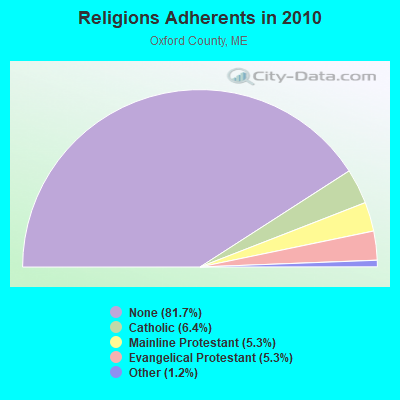
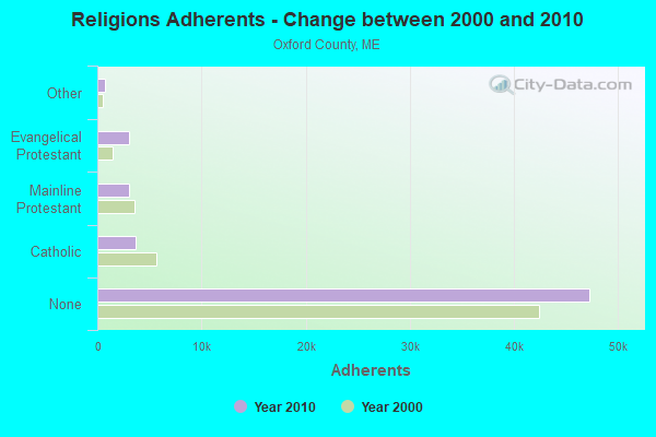
| Religion | Adherents | Congregations |
|---|---|---|
| Catholic | 3,708 | 7 |
| Mainline Protestant | 3,085 | 45 |
| Evangelical Protestant | 3,045 | 37 |
| Other | 719 | 14 |
| None | 47,276 | - |
Food Environment Statistics:
| Oxford County: | 2.47 / 10,000 pop. |
| State: | 2.80 / 10,000 pop. |
| Oxford County: | 0.35 / 10,000 pop. |
| Maine: | 0.14 / 10,000 pop. |
| Here: | 2.29 / 10,000 pop. |
| Maine: | 2.20 / 10,000 pop. |
| Oxford County: | 7.94 / 10,000 pop. |
| Maine: | 5.75 / 10,000 pop. |
| Oxford County: | 9.35 / 10,000 pop. |
| Maine: | 11.02 / 10,000 pop. |
| Oxford County: | 7.6% |
| Maine: | 8.2% |
| Oxford County: | 25.6% |
| Maine: | 25.0% |
| Businesses in Bethel, ME | ||||
| Name | Count | Name | Count | |
|---|---|---|---|---|
| Circle K | 2 | MasterBrand Cabinets | 4 | |
| Dunkin Donuts | 1 | Rite Aid | 1 | |
| FedEx | 1 | Subway | 1 | |
| GNC | 1 | True Value | 1 | |
Strongest AM radio stations in Bethel:
- WTME (780 AM; 10 kW; RUMFORD, ME; Owner: MOUNTAIN VALLEY BROADCASTING, INC.)
- WMTW (870 AM; 10 kW; GORHAM, ME; Owner: RADIO PARTNERS OF MAINE, L.P.)
- WRKO (680 AM; 50 kW; BOSTON, MA; Owner: ENTERCOM BOSTON LICENSE, LLC)
- WGAN (560 AM; 5 kW; PORTLAND, ME; Owner: SAGA COMMUNICATIONS OF NEW ENGLAND, LLC)
- WLAM (1470 AM; 5 kW; LEWISTON, ME; Owner: RADIO PARTNERS OF MAINE, L.P.)
- WEEI (850 AM; 50 kW; BOSTON, MA; Owner: ENTERCOM BOSTON LICENSE, LLC)
- WSKW (1160 AM; 10 kW; SKOWHEGAN, ME; Owner: MOUNTAIN WIRELESS, INCORPORATED)
- WCHP (760 AM; 35 kW; CHAMPLAIN, NY; Owner: CHAMPLAIN RADIO, INC.)
- WCRN (830 AM; 50 kW; WORCESTER, MA; Owner: CARTER BROADCASTING CORPORATION)
- WBZ (1030 AM; 50 kW; BOSTON, MA; Owner: INFINITY BROADCASTING OPERATIONS, INC.)
- WNNZ (640 AM; 50 kW; WESTFIELD, MA; Owner: CLEAR CHANNEL BROADCASTING LICENSES, INC.)
- WMOU (1230 AM; 1 kW; BERLIN, NH; Owner: JERICHO BROADCASTING COMPANY, L.L.C.)
- WKTQ (1450 AM; 1 kW; SOUTH PARIS, ME; Owner: PENNESSEEWASSEE BROADCASTING CO INC.)
Strongest FM radio stations in Bethel:
- WPKQ (103.7 FM; NORTH CONWAY, NH; Owner: CITADEL BROADCASTING COMPANY)
- WHOM (94.9 FM; MT. WASHINGTON, NH; Owner: CITADEL BROADCASTING COMPANY)
- WLOB-FM (96.3 FM; RUMFORD, ME; Owner: ATLANTIC COAST RADIO, LLC)
- WTBM (100.7 FM; MEXICO, ME; Owner: MOUNTAIN VALLEY BROADCASTING, INC.)
- WMEA (90.1 FM; PORTLAND, ME; Owner: MAINE PUBLIC BROADCASTING CORPORATION)
- WTOS-FM (105.1 FM; SKOWHEGAN, ME; Owner: CAPSTAR TX LIMITED PARTNERSHIP)
- WBLM (102.9 FM; PORTLAND, ME; Owner: CITADEL BROADCASTING COMPANY)
- WVFM (105.7 FM; CAMPTON, NH; Owner: DEVON BROADCASTING COMPANY, INC.)
- WSCY (106.9 FM; MOULTONBOROUGH, NH; Owner: NORTHEAST COMMUNICATIONS CORPORATION)
- WGMT (97.7 FM; LYNDON, VT; Owner: VERMONT BROADCAST ASSOCIATES, INC.)
- WOXO-FM (92.7 FM; NORWAY, ME; Owner: TRI-COUNTY BROADCASTING, INC.)
- WMTK (106.3 FM; LITTLETON, NH; Owner: VERMONT BROADCAST ASSOCIATES, INC.)
- WTHT (107.5 FM; LEWISTON, ME; Owner: RADIO PARTNERS OF MAINE, L.P.)
- WXXS (102.3 FM; LANCASTER, NH; Owner: BARRY P. LUNDERVILLE)
TV broadcast stations around Bethel:
- W04BS (Channel 4; BETHEL, ETC., ME; Owner: MAINE PUBLIC BROADCASTING CORPORATION)
- WGME-TV (Channel 13; PORTLAND, ME; Owner: WGME LICENSEE, LLC)
- WMTW-TV (Channel 8; POLAND SPRING, ME; Owner: WMTW BROADCAST GROUP, LLC)
- WCSH (Channel 6; PORTLAND, ME; Owner: PACIFIC AND SOUTHERN COMPANY, INC.)
- National Bridge Inventory (NBI) Statistics
- 8Number of bridges
- 105ft / 32.3mTotal length
- 833,619Total average daily traffic
- 41,677Total average daily truck traffic
- 43,082Total future (year 2036) average daily traffic
FCC Registered Antenna Towers:
47 (See the full list of FCC Registered Antenna Towers in Bethel)FCC Registered Broadcast Land Mobile Towers:
7- Fire Station Rt 5 (Lat: 44.405889 Lon: -70.790611), Call Sign: WXR378,
Assigned Frequencies: 154.070 MHz, 154.310 MHz, Grant Date: 06/21/2023, Expiration Date: 02/03/2033, Registrant: Town Of Bethel, Po Box 1660, Bethel, ME 04217, Phone: (207) 824-2669, Email:
- Fire Sation Rt 5 (Lat: 44.405889 Lon: -70.790611), Call Sign: KSE721,
Assigned Frequencies: 153.995 MHz, 154.025 MHz, Grant Date: 06/21/2023, Expiration Date: 05/04/2033, Registrant: Business Radio Licensing, 26941 Cabot Road #134, Laguna Hills, CA 92653, Phone: (949) 348-8510
- Slr R O W (Lat: 44.375056 Lon: -70.957861), Structure height: 9 m, Call Sign: WNPW494, Licensee ID: L00077471,
Assigned Frequencies: 160.815 MHz, 160.965 MHz, Grant Date: 11/19/1997, Expiration Date: 12/04/2002, Cancellation Date: 03/09/2003, Registrant: Saint Lawrence & Atlantic Railroad Company, 96 S George St, York, PA 17401, Phone: (207) 782-5680
- Mayville Rd (Lat: 44.415056 Lon: -70.795583), Type: Pole, Structure height: 3.6 m, Overall height: 4.5 m, Call Sign: WQAZ694,
Assigned Frequencies: 452.275 MHz, Grant Date: 08/26/2014, Expiration Date: 09/01/2024, Certifier: Rob Gunderson, Registrant: Federal License Management, 1784 E. 3rd Street Suite 269, Williamsport, PA 17701-3862, Phone: (866) 908-2220, Fax: (570) 322-6825, Email:
- 284 Walkers Mills Road (Lat: 44.418611 Lon: -70.765278), Type: Building, Structure height: 9 m, Call Sign: WRZH426,
Assigned Frequencies: 462.775 MHz, Grant Date: 11/02/2023, Expiration Date: 11/02/2033, Certifier: Mark Kenney, Registrant: Visiplex, 1287 Barclay Boulevard, Buffalo Grove, IL 60089, Phone: (847) 229-0250, Email:
- BARKER MOUNTAIN, Skyway Road (010351) (Lat: 44.457389 Lon: -70.866417), Type: Ltower, Structure height: 34.7 m, Overall height: 37.7 m, Call Sign: WSAZ741,
Assigned Frequencies: 155.070 MHz, Grant Date: 02/26/2024, Expiration Date: 02/26/2034, Certifier: Geoff Inman, Registrant: Radio Communications Management, 158 Rand Rd, Portland, ME 04103, Phone: (207) 797-7503, Email:
- BARKER MOUNTAIN, Skyway Road (010351) (Lat: 44.457389 Lon: -70.866417), Type: Ltower, Structure height: 34.7 m, Overall height: 37.7 m, Call Sign: WSBN581,
Assigned Frequencies: 154.070 MHz, Grant Date: 03/04/2024, Expiration Date: 03/04/2034, Certifier: Geoff Inman, Registrant: Radio Communications Management, 158 Rand Rd, Portland, ME 04103, Phone: (207) 797-7503, Email:
FCC Registered Microwave Towers:
8 (See the full list of FCC Registered Microwave Towers in this town)FCC Registered Maritime Coast & Aviation Ground Towers:
1 (See the full list of FCC Registered Maritime Coast & Aviation Ground Towers)FCC Registered Amateur Radio Licenses:
23 (See the full list of FCC Registered Amateur Radio Licenses in Bethel)FAA Registered Aircraft:
9 (See the full list of FAA Registered Aircraft in Bethel)2004 - 2018 National Fire Incident Reporting System (NFIRS) incidents
- Fire incident types reported to NFIRS in Bethel, ME
- 6758.3%Structure Fires
- 2420.9%Outside Fires
- 1916.5%Mobile Property/Vehicle Fires
- 54.3%Other
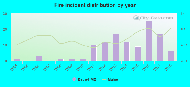 Based on the data from the years 2004 - 2018 the average number of fires per year is 8. The highest number of reported fires - 25 took place in 2016, and the least - 0 in 2005. The data has an increasing trend.
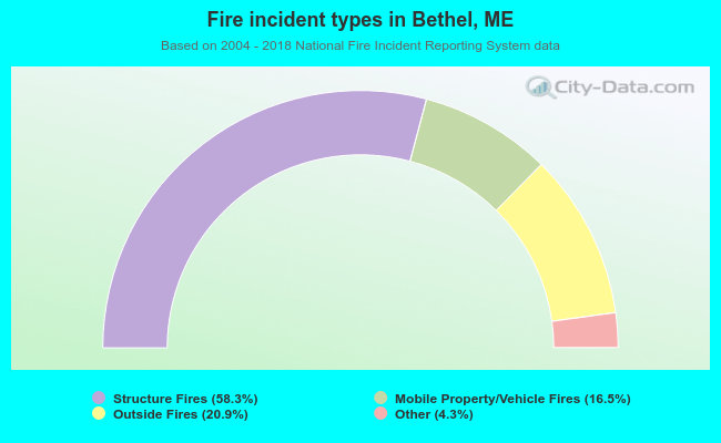 When looking into fire subcategories, the most reports belonged to: Structure Fires (58.3%), and Outside Fires (20.9%).
Fire-safe hotels and motels in Bethel, Maine:
- The Bethel Inn And Country Club, Broad St, Bethel, Maine 04217 , Phone: (207) 824-2175, Fax: (207) 824-2233
- Norseman Inn & Motel, 134 Mayville Rd, Bethel, Maine 04217 , Phone: (207) 824-2002, Fax: (207) 824-0640
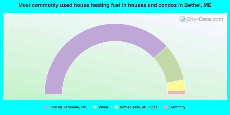
- 76.3%Fuel oil, kerosene, etc.
- 17.1%Wood
- 4.9%Bottled, tank, or LP gas
- 1.7%Electricity
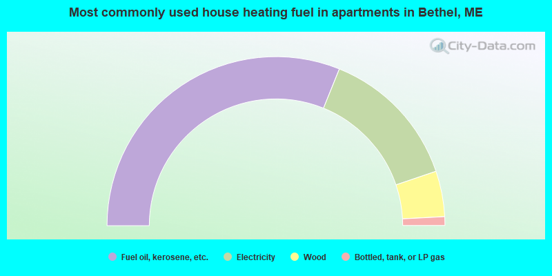
- 62.2%Fuel oil, kerosene, etc.
- 27.3%Electricity
- 8.7%Wood
- 1.7%Bottled, tank, or LP gas
Bethel compared to Maine state average:
- Unemployed percentage significantly below state average.
- Black race population percentage below state average.
- Foreign-born population percentage below state average.
- Length of stay since moving in significantly above state average.
- Number of rooms per house significantly below state average.
- House age significantly below state average.
- Number of college students below state average.

|
Total of 17 patent applications in 2008-2024.