Beryl-Newcastle, Utah
Submit your own pictures of this place and show them to the world
- OSM Map
- Google Map
- MSN Map
| Males: 752 | |
| Females: 708 |
| Median resident age: | 29.3 years |
| Utah median age: | 27.1 years |
Zip code: 84714
| Beryl-Newcastle: | $58,343 |
| UT: | $89,168 |
Estimated per capita income in 2022: $18,545 (it was $9,076 in 2000)
Beryl-Newcastle CCD income, earnings, and wages data
Estimated median house or condo value in 2022: $275,164 (it was $81,400 in 2000)
| Beryl-Newcastle: | $275,164 |
| UT: | $499,500 |
Beryl-Newcastle, UT residents, houses, and apartments details
Detailed information about poverty and poor residents in Beryl-Newcastle, UT
Compare current foreclosures near your location:
| Photo | Address | Area | Beds / Baths | Price | Details |
|---|---|---|---|---|---|

|
#1
E 21st Ave
Columbus, OH 43211
|
1,061 sq. feet
|
1 baths 3 beds |
$179,900
|
show details |

|
#2
S High St
Columbus, OH 43207
|
1,678 sq. feet
|
2 baths 4 beds |
$31,900
|
show details |

|
#3
Bayberry Cir
Columbus, OH 43207
|
1,564 sq. feet
|
1 baths 3 beds |
$127,500
|
show details |

|
#4
Armada Rd
Columbus, OH 43232
|
1,028 sq. feet
|
1 baths 4 beds |
show details | |

|
#5
Grasmere Ave
Columbus, OH 43211
|
720 sq. feet
|
1 baths 2 beds |
show details | |

|
#6
Safford Ave
Columbus, OH 43223
|
784 sq. feet
|
1 baths 2 beds |
show details | |

|
#7
Scottwood Rd
Columbus, OH 43227
|
1,008 sq. feet
|
1 baths 3 beds |
show details | |

|
#8
Summertree Ln
Westerville, OH 43081
|
2,496 sq. feet
|
2 baths 3 beds |
show details | |

|
#9
Derrer Rd -872
Columbus, OH 43204
|
1,667 sq. feet
|
2 baths 5 beds |
show details | |

|
#10
Wrexham Ave
Columbus, OH 43223
|
1,235 sq. feet
|
1 baths 3 beds |
show details |
| Photo | Address | Area | Beds / Baths | Price | Details |
|---|---|---|---|---|---|

|
#11
Lehner Rd
Columbus, OH 43224
|
1,628 sq. feet
|
2 baths 4 beds |
show details | |

|
#12
Fahlander Dr N
Columbus, OH 43229
|
1,338 sq. feet
|
2 baths 3 beds |
show details | |

|
#13
High Free Pike
West Jefferson, OH 43162
|
1,216 sq. feet
|
2 baths 4 beds |
show details | |

|
#14
S Richardson Ave
Columbus, OH 43204
|
1,520 sq. feet
|
2 baths 3 beds |
show details | |

|
#15
Brookstone Dr
Westerville, OH 43082
|
1,783 sq. feet
|
3 baths 3 beds |
show details | |

|
#16
E Howard Rd
Columbus, OH 43207
|
1,056 sq. feet
|
1 baths 3 beds |
show details | |

|
#17
Midland Ave
Columbus, OH 43223
|
1,518 sq. feet
|
1 baths 2 beds |
show details | |

|
#18
Marshrun Dr
Grove City, OH 43123
|
2,036 sq. feet
|
2 baths 4 beds |
show details | |

|
#19
N Roys Ave
Columbus, OH 43204
|
1,248 sq. feet
|
2 baths 3 beds |
show details | |

|
#20
Meadowbrook Dr
Columbus, OH 43207
|
1,752 sq. feet
|
2 baths 4 beds |
show details |
| Photo | Address | Area | Beds / Baths | Price | Details |
|---|---|---|---|---|---|

|
#21
Stoneybrook Blvd # 21a
Hilliard, OH 43026
|
1,231 sq. feet
|
2 baths 3 beds |
show details | |

|
#22
Mink St SW
Pataskala, OH 43062
|
1,442 sq. feet
|
1 baths 3 beds |
show details | |

|
#23
London Groveport Rd
Grove City, OH 43123
|
816 sq. feet
|
1 baths 2 beds |
show details | |

|
#24
Glenmate Ct
Columbus, OH 43223
|
1,050 sq. feet
|
1 baths 3 beds |
show details | |

|
#25
Gladys Rd
Columbus, OH 43228
|
832 sq. feet
|
1 baths 3 beds |
show details | |

|
#26
Striebel Ct
Columbus, OH 43227
|
925 sq. feet
|
1 baths 3 beds |
show details | |

|
#27
N 18th St
Columbus, OH 43203
|
1,690 sq. feet
|
1 baths 4 beds |
show details | |

|
#28
Fergus Rd
Grove City, OH 43123
|
3,312 sq. feet
|
2 baths 4 beds |
show details | |

|
#29
Chester Rd
Columbus, OH 43221
|
3,300 sq. feet
|
4 baths 5 beds |
show details | |

|
#30
Sleeping Meadow Dr
New Albany, OH 43054
|
3,211 sq. feet
|
2 baths 4 beds |
show details |
| Photo | Address | Area | Beds / Baths | Price | Details |
|---|---|---|---|---|---|

|
#31
E Welch Ave
Columbus, OH 43207
|
1,864 sq. feet
|
2 baths 4 beds |
show details | |

|
#32
Kingsglen Dr
Grove City, OH 43123
|
1,635 sq. feet
|
2 baths 4 beds |
show details | |

|
#33
S Hague Ave
Columbus, OH 43204
|
979 sq. feet
|
1 baths 2 beds |
show details | |

|
#34
Ashgrove Dr
Grove City, OH 43123
|
1,772 sq. feet
|
2 baths 4 beds |
show details | |

|
#35
Chidley St
Galloway, OH 43119
|
1,502 sq. feet
|
1 baths 3 beds |
show details | |

|
#36
Hildreth Ave
Columbus, OH 43203
|
1,798 sq. feet
|
2 baths 4 beds |
show details | |

|
#37
Fairfield Ave
Columbus, OH 43203
|
984 sq. feet
|
1 baths 2 beds |
show details | |

|
#38
Ratify Blvd
Columbus, OH 43207
|
1,356 sq. feet
|
2 baths 3 beds |
show details | |

|
#39
Andrus Ave
Columbus, OH 43227
|
1,264 sq. feet
|
1 baths 3 beds |
show details | |

|
#40
Berrywood Dr
Columbus, OH 43220
|
1,182 sq. feet
|
1 baths 2 beds |
show details |
| Photo | Address | Area | Beds / Baths | Price | Details |
|---|---|---|---|---|---|

|
#41
Simpson Dr
Columbus, OH 43227
|
1,104 sq. feet
|
1 baths 3 beds |
show details | |

|
#42
Nantucket Ave
Columbus, OH 43235
|
1,864 sq. feet
|
2 baths 3 beds |
show details | |

|
#43
Bostwick Rd
Columbus, OH 43227
|
1,284 sq. feet
|
1 baths 4 beds |
show details | |

|
#44
Messner Dr
Hilliard, OH 43026
|
832 sq. feet
|
1 baths 2 beds |
show details | |

|
#45
Camhurst Ct
Galloway, OH 43119
|
1,969 sq. feet
|
2 baths 3 beds |
show details | |

|
#46
Illinois Ave
Westerville, OH 43081
|
1,120 sq. feet
|
1 baths 3 beds |
show details | |

|
#47
Renford Ct
Powell, OH 43065
|
1,795 sq. feet
|
1 baths 3 beds |
show details | |

|
#48
Casa Blvd
Grove City, OH 43123
|
1,002 sq. feet
|
1 baths 2 beds |
show details | |

|
#49
Mango Ln
Hilliard, OH 43026
|
1,024 sq. feet
|
1 baths 2 beds |
show details | |

|
Check over 1 million property listings on Foreclosure.com!
|
browse all offers | |||

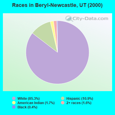
- 97885.3%White alone
- 12510.9%Hispanic
- 201.7%American Indian alone
- 181.6%Two or more races
- 50.4%Black alone
- 10.09%Native Hawaiian and Other
Pacific Islander alone
Races in Beryl-Newcastle detailed stats: ancestries, foreign born residents, place of birth
 Recent articles from our blog. Our writers, many of them Ph.D. graduates or candidates, create easy-to-read articles on a wide variety of topics.
Current Local Time: MST time zone
Land area: 1481.0 square miles.
Population density: 1.0 people per square mile (very low).
| Beryl-Newcastle CCD: | 0.5% ($420) |
| Utah: | 0.7% ($956) |
Nearest city with pop. 50,000+: North Las Vegas, NV  (137.2 miles , pop. 115,488).
Nearest city with pop. 200,000+: Las Vegas, NV (141.6 miles , pop. 478,434).
Nearest city with pop. 1,000,000+: Phoenix, AZ (308.4 miles , pop. 1,321,045).
Nearest cities:
), ), ), Latitude: 37.80 N, Longitude: 113.64 W
| Here: | 2.5% |
| Utah: | 2.5% |
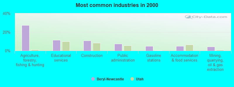
- Agriculture, forestry, fishing & hunting (27.3%)
- Educational services (11.4%)
- Construction (11.0%)
- Public administration (7.5%)
- Gasoline stations (4.9%)
- Accommodation & food services (4.9%)
- Mining, quarrying, oil & gas extraction (4.4%)
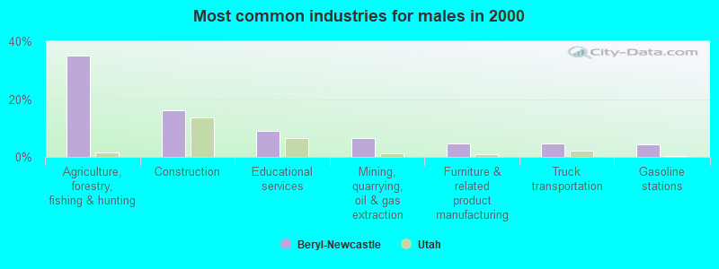
- Agriculture, forestry, fishing & hunting (35.0%)
- Construction (16.0%)
- Educational services (8.8%)
- Mining, quarrying, oil & gas extraction (6.5%)
- Furniture & related product manufacturing (4.8%)
- Truck transportation (4.8%)
- Gasoline stations (4.4%)
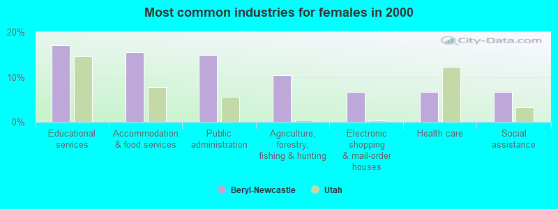
- Educational services (17.0%)
- Accommodation & food services (15.6%)
- Public administration (14.8%)
- Agriculture, forestry, fishing & hunting (10.4%)
- Electronic shopping & mail-order houses (6.7%)
- Health care (6.7%)
- Social assistance (6.7%)
- Agricultural workers, including supervisors (23.1%)
- Other management occupations, except farmers and farm managers (8.2%)
- Preschool, kindergarten, elementary, and middle school teachers (7.7%)
- Driver/sales workers and truck drivers (7.7%)
- Vehicle and mobile equipment mechanics, installers, and repairers (5.1%)
- Electrical equipment mechanics and other installation, maintenance, and repair workers, including supervisors (4.7%)
- Farmers and farm managers (4.2%)
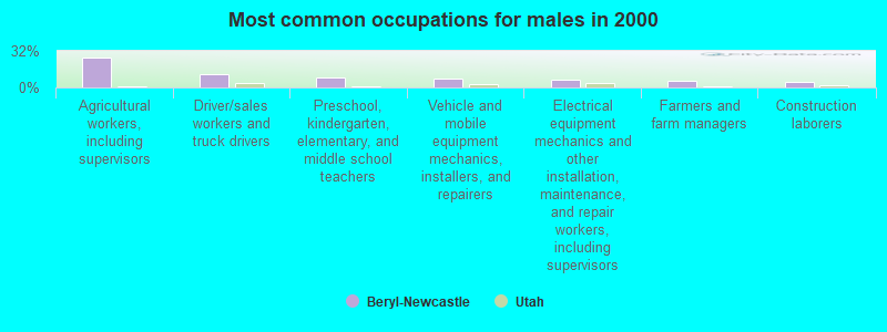
- Agricultural workers, including supervisors (26.5%)
- Driver/sales workers and truck drivers (11.2%)
- Preschool, kindergarten, elementary, and middle school teachers (8.8%)
- Vehicle and mobile equipment mechanics, installers, and repairers (7.5%)
- Electrical equipment mechanics and other installation, maintenance, and repair workers, including supervisors (6.8%)
- Farmers and farm managers (6.1%)
- Construction laborers (5.1%)
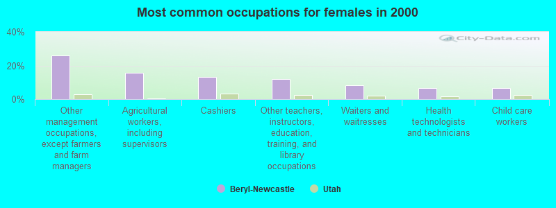
- Other management occupations, except farmers and farm managers (25.9%)
- Agricultural workers, including supervisors (15.6%)
- Cashiers (13.3%)
- Other teachers, instructors, education, training, and library occupations (11.9%)
- Waiters and waitresses (8.1%)
- Health technologists and technicians (6.7%)
- Child care workers (6.7%)
Average climate in Beryl-Newcastle, Utah
Based on data reported by over 4,000 weather stations


Earthquake activity:
Beryl-Newcastle-area historical earthquake activity is significantly above Utah state average. It is 4098% greater than the overall U.S. average.On 10/3/1915 at 06:52:48, a magnitude 7.6 (7.6 UK, Class: Major, Intensity: VIII - XII) earthquake occurred 278.8 miles away from the city center
On 6/28/1992 at 11:57:34, a magnitude 7.6 (6.2 MB, 7.6 MS, 7.3 MW, Depth: 0.7 mi) earthquake occurred 298.2 miles away from Beryl-Newcastle center, causing 3 deaths (1 shaking deaths, 2 other deaths) and 400 injuries, causing $100,000,000 total damage and $40,000,000 insured losses
On 10/16/1999 at 09:46:44, a magnitude 7.4 (6.3 MB, 7.4 MS, 7.2 MW, 7.3 ML) earthquake occurred 275.9 miles away from the city center
On 12/21/1932 at 06:10:09, a magnitude 7.2 (7.2 UK) earthquake occurred 246.8 miles away from the city center
On 7/21/1952 at 11:52:14, a magnitude 7.7 (7.7 UK) earthquake occurred 355.9 miles away from Beryl-Newcastle center, causing $50,000,000 total damage
On 12/16/1954 at 11:07:12, a magnitude 7.0 (7.0 UK) earthquake occurred 255.2 miles away from the city center
Magnitude types: body-wave magnitude (MB), local magnitude (ML), surface-wave magnitude (MS), moment magnitude (MW)
Natural disasters:
The number of natural disasters in Iron County (4) is a lot smaller than the US average (15).Major Disasters (Presidential) Declared: 1
Emergencies Declared: 2
Causes of natural disasters: Drought: 1, Flood: 1, Hurricane: 1, Landslide: 1, Other: 1 (Note: some incidents may be assigned to more than one category).
Colleges/universities with over 2000 students nearest to Beryl-Newcastle:
- Southern Utah University (about 33 miles; Cedar City, UT; Full-time enrollment: 6,522)
- Dixie State University (about 49 miles; Saint George, UT; FT enrollment: 6,485)
- University of Nevada-Las Vegas (about 144 miles; Las Vegas, NV; FT enrollment: 21,153)
- College of Southern Nevada (about 144 miles; Las Vegas, NV; FT enrollment: 18,996)
- Nevada State College (about 145 miles; Henderson, NV; FT enrollment: 2,346)
- Snow College (about 155 miles; Ephraim, UT; FT enrollment: 3,224)
- Mohave Community College (about 177 miles; Kingman, AZ; FT enrollment: 3,309)
Points of interest:
Notable locations in Beryl-Newcastle: Gold Springs (A), CCC Camp (B), Jessie Tie Exclosure (C), Johnston Ranch (D), State Line (E), Iron Mountain Wye (F), Pipeline Spring Trough (G), Butcher Spring Trough (H), Chaney Ranch (I), Clark Farm (J), Uvada (K), Page Ranch (L), Hamblin Valley Fire and Rescue (M), Beryl Fire Department (N), Newcastle Fire Department (O). Display/hide their locations on the map
Churches in Beryl-Newcastle include: Beryl Baptist Church (A), The Church of Jesus Christ of Latter Day Saints (B). Display/hide their locations on the map
Cemeteries: State Line Cemetery (1), Modena Cemetery (2), Newcastle Cemetery (3). Display/hide their locations on the map
Lakes and reservoirs: Mud Lake (A), Crestline Reservoir (B), Rose Valley Reservoir (C), Newcastle Reservoir (D), Lamb Reservoir (E), Modena Draw Reservoir (F), Modena Reservoir (G), Modena City Reservoir (H). Display/hide their locations on the map
Streams, rivers, and creeks: Tillie Creek (A), Chokecherry Creek (B), Gold Springs Wash (C), Shoal Creek (D), Pinto Creek (E), Pine Creek (F). Display/hide their locations on the map
Park in Beryl-Newcastle: Jefferson Hunt Monument (1). Display/hide its location on the map
| This place: | 3.0 people |
| Utah: | 3.1 people |
| This place: | 67.7% |
| Whole state: | 75.2% |
| This place: | 4.8% |
| Whole state: | 4.6% |
Likely homosexual households (counted as self-reported same-sex unmarried-partner households)
- Lesbian couples: 0.2% of all households
- Gay men: 0.7% of all households
| This place: | 30.5% |
| Whole state: | 9.4% |
| This place: | 19.6% |
| Whole state: | 3.9% |
4 people in correctional facilities intended for juveniles in 2010
3 people in nursing homes in 2000
3 people in other noninstitutional group quarters in 2000
For population 15 years and over in Beryl-Newcastle:
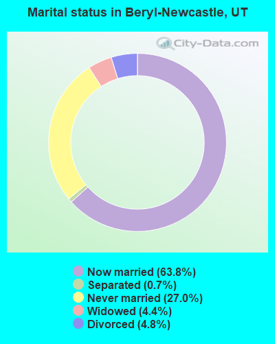
- Never married: 27.0%
- Now married: 63.8%
- Separated: 0.7%
- Widowed: 4.4%
- Divorced: 4.8%
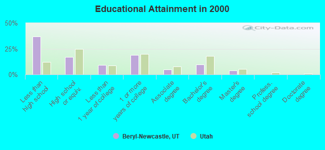
For population 25 years and over in Beryl-Newcastle:
- High school or higher: 63.1%
- Bachelor's degree or higher: 13.6%
- Graduate or professional degree: 3.7%
- Unemployed: 5.9%
- Mean travel time to work (commute): 25.2 minutes
| Here: | 13.6 |
| Utah average: | 10.5 |
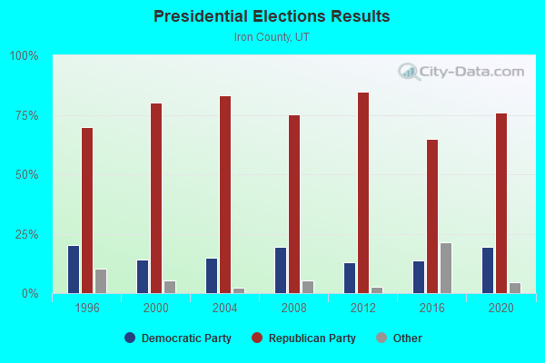
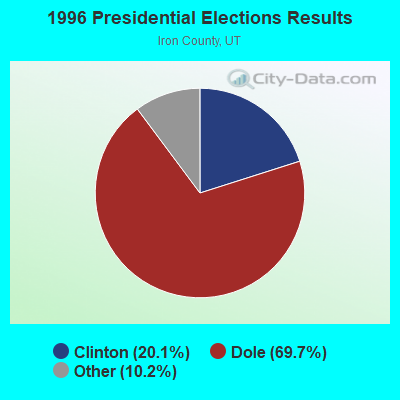
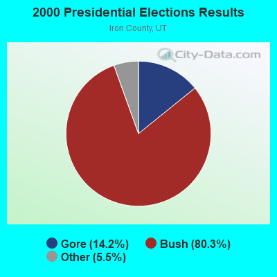
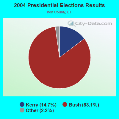

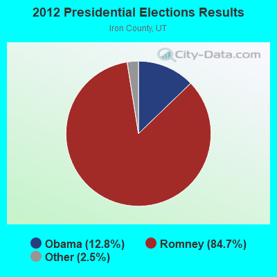
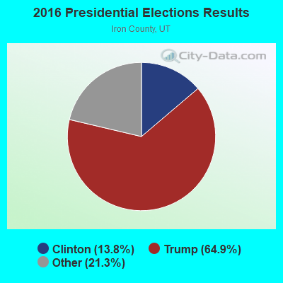
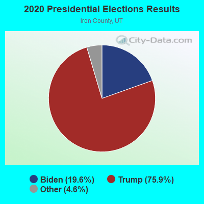
Graphs represent county-level data. Detailed 2008 Election Results
Religion statistics for Beryl-Newcastle, UT (based on Iron County data)
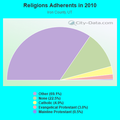
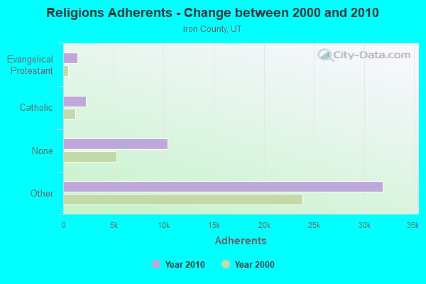
| Religion | Adherents | Congregations |
|---|---|---|
| Other | 31,886 | 98 |
| Catholic | 2,248 | 2 |
| Evangelical Protestant | 1,384 | 12 |
| Mainline Protestant | 252 | 2 |
| None | 10,393 | - |
Food Environment Statistics:
| Iron County: | 0.92 / 10,000 pop. |
| Utah: | 1.37 / 10,000 pop. |
| This county: | 0.23 / 10,000 pop. |
| State: | 0.18 / 10,000 pop. |
| Iron County: | 0.46 / 10,000 pop. |
| Utah: | 0.41 / 10,000 pop. |
| Iron County: | 4.83 / 10,000 pop. |
| State: | 2.82 / 10,000 pop. |
| Here: | 6.44 / 10,000 pop. |
| State: | 5.09 / 10,000 pop. |
| This county: | 5.5% |
| Utah: | 6.3% |
| Iron County: | 21.1% |
| Utah: | 23.6% |
Strongest AM radio stations in Beryl-Newcastle:
- KNNZ (940 AM; 10 kW; CEDAR CITY, UT; Owner: MB MEDIA GROUP, INC.)
- KSUB (590 AM; 5 kW; CEDAR CITY, UT; Owner: MB MEDIA GROUP, INC.)
- KDXU (890 AM; 10 kW; ST. GEORGE, UT; Owner: WESTERN BROADCASTING, LS, LLC)
- KXNT (840 AM; 50 kW; NORTH LAS VEGAS, NV; Owner: INFINITY RADIO OPERATIONS INC.)
- KUNF (1210 AM; 10 kW; WASHINGTON, UT; Owner: MARATHON MEDIA GROUP, L.L.C.)
- KDWN (720 AM; 50 kW; LAS VEGAS, NV; Owner: RADIO NEVADA CORP.)
- KZNU (1450 AM; 10 kW; ST. GEORGE, UT; Owner: AM RADIO 1450, INC.)
- KALL (700 AM; 50 kW; NORTH SALT LAKE CITY, UT; Owner: CITICASTERS LICENSES, L.P.)
- KIQN (1010 AM; 50 kW; TOOELE, UT)
- KMIA (710 AM; 50 kW; BLACK CANYON CITY, AZ; Owner: ENTRAVISION HOLDINGS, LLC)
- KTNN (660 AM; 50 kW; WINDOW ROCK, AZ; Owner: THE NAVAJO NATION)
- KSL (1160 AM; 50 kW; SALT LAKE CITY, UT; Owner: BONNEVILLE HOLDING COMPANY)
- KMJ (580 AM; 50 kW; FRESNO, CA; Owner: INFINITY RADIO OPERATIONS INC.)
Strongest FM radio stations in Beryl-Newcastle:
- KXFF (92.5 FM; CEDAR CITY, UT; Owner: MB MEDIA GROUP, INC.)
- KREC (98.1 FM; BRIAN HEAD, UT; Owner: MARATHON MEDIA GROUP, L.L.C.)
- K300AC (107.9 FM; WASHINGTON, ETC., UT; Owner: UNIVERSITY OF UTAH)
- K203CA (88.5 FM; MILFORD, UT; Owner: UNIVERSITY OF UTAH)
- KLNR (91.7 FM; PANACA, NV; Owner: NEVADA PUBLIC RADIO CORPORATION)
- KBZB (98.9 FM; PIOCHE, NV; Owner: GLA-MAR BROADCASTING, LLC)
- K202AW (88.3 FM; CEDAR CITY, UT; Owner: UNIVERSITY OF UTAH)
- KZHK (95.9 FM; ST. GEORGE, UT; Owner: MARVIN KENT FRANDSEN)
TV broadcast stations around Beryl-Newcastle:
- K29FA (Channel 29; MODENA, UT; Owner: IRON COUNTY)
- K51GS (Channel 51; NEW CASTLE, ETC, UT; Owner: IRON COUNTY)
- K17FF (Channel 17; MODENA, ETC., UT; Owner: IRON COUNTY)
- K25GY (Channel 25; MODENA, ETC., UT; Owner: IRON COUNTY)
- K27GB (Channel 27; MODENA, ETC., UT; Owner: IRON COUNTY)
- 39.2%Electricity
- 19.6%Utility gas
- 17.0%Wood
- 11.3%Fuel oil, kerosene, etc.
- 9.8%Bottled, tank, or LP gas
- 3.0%Coal or coke
- 74.0%Electricity
- 15.0%Wood
- 11.0%Fuel oil, kerosene, etc.
Beryl-Newcastle compared to Utah state average:
- Median household income below state average.
- Median house value below state average.
- Unemployed percentage below state average.
- Foreign-born population percentage significantly below state average.
- Length of stay since moving in significantly above state average.
- Number of rooms per house significantly below state average.
- House age significantly below state average.
- Number of college students significantly below state average.
- Percentage of population with a bachelor's degree or higher below state average.
Beryl-Newcastle on our top lists:
- #83 on the list of "Top 100 cities with largest land areas"
- #92 on the list of "Top 101 cities with the least people driving a car to work alone (population 500+)"
- #58 on the list of "Top 101 counties with the most Other congregations"
- #85 on the list of "Top 101 counties with highest percentage of residents voting for Romney (Republican) in the 2012 Presidential Election"
- #86 on the list of "Top 101 counties with the most Other adherents"