Bancroft, Maine
Submit your own pictures of this town and show them to the world
- OSM Map
- General Map
- Google Map
- MSN Map
Population change since 2000: +11.5%
 |
| Males: 35 | |
| Females: 33 |
| Median resident age: | 55.0 years |
| Maine median age: | 43.0 years |
Zip code: 04497
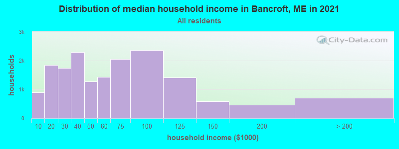
| Bancroft: | $28,962 |
| ME: | $69,543 |
Estimated per capita income in 2022: $20,143 (it was $9,760 in 2000)
Estimated median house or condo value in 2022: $90,796 (it was $37,500 in 2000)
| Bancroft: | $90,796 |
| ME: | $290,600 |
Mean prices in 2022: all housing units: $179,108; detached houses: $185,023; townhouses or other attached units: $218,327; in 2-unit structures: $262,505; in 3-to-4-unit structures: $121,406; in 5-or-more-unit structures: $185,084; mobile homes: $117,009; occupied boats, rvs, vans, etc.: $12,682


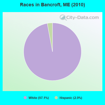
- 6697.1%White alone
- 22.9%Hispanic
According to our research of Maine and other state lists, there was 1 registered sex offender living in Bancroft, Maine as of May 19, 2024.
The ratio of all residents to sex offenders in Bancroft is 68 to 1.
 Recent articles from our blog. Our writers, many of them Ph.D. graduates or candidates, create easy-to-read articles on a wide variety of topics.

 | Maine weather thread (3207 replies) |
| Spring Flooding (4 replies) |
| Looking for a electrician (3 replies) |
| Commute for work in north maine (8 replies) |
| Probally been asked before, but Northwest maine seems a whole lot of nothing with high wages... (20 replies) |
| Unorganized Territories in Maine... (33 replies) |
Latest news from Bancroft, ME collected exclusively by city-data.com from local newspapers, TV, and radio stations
Ancestries: Irish (34.4%), English (26.2%), Dutch (9.8%), French (4.9%), Scotch-Irish (4.9%), Danish (3.3%).
Current Local Time: EST time zone
Incorporated on 02/05/1889
Elevation: 340 feet
Land area: 40.0 square miles.
Population density: 1.7 people per square mile (very low).
| Bancroft town: | 0.9% ($350) |
| Maine: | 1.5% ($1,417) |
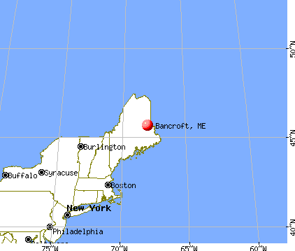
Nearest city with pop. 50,000+: Portland, ME  (180.1 miles , pop. 64,249).
Nearest city with pop. 200,000+: Boston, MA (280.1 miles , pop. 589,141).
Nearest city with pop. 1,000,000+: Bronx, NY (447.6 miles , pop. 1,332,650).
Nearest cities:
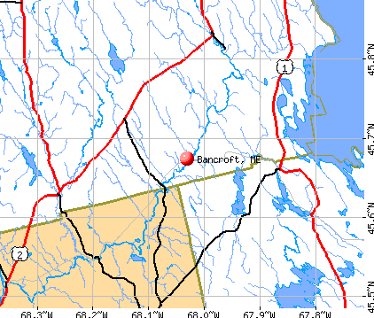
), ), )Latitude: 45.71 N, Longitude: 68.00 W
Area code commonly used in this area: 207

| Here: | 4.8% |
| Maine: | 3.4% |
Average climate in Bancroft, Maine
Based on data reported by over 4,000 weather stations


Earthquake activity:
Bancroft-area historical earthquake activity is significantly above Maine state average. It is 84% smaller than the overall U.S. average.On 4/20/2002 at 10:50:47, a magnitude 5.3 (5.3 ML, Depth: 3.0 mi, Class: Moderate, Intensity: VI - VII) earthquake occurred 290.1 miles away from the city center
On 10/16/2012 at 23:12:25, a magnitude 4.7 (4.7 ML, Depth: 10.0 mi, Class: Light, Intensity: IV - V) earthquake occurred 196.0 miles away from Bancroft center
On 4/20/2002 at 10:50:47, a magnitude 5.2 (5.2 MB, 4.2 MS, 5.2 MW, 5.0 MW) earthquake occurred 291.6 miles away from the city center
On 10/7/1983 at 10:18:46, a magnitude 5.3 (5.1 MB, 5.3 LG, 5.1 ML) earthquake occurred 333.9 miles away from the city center
On 1/19/1982 at 00:14:42, a magnitude 4.7 (4.5 MB, 4.7 MD, 4.5 LG) earthquake occurred 234.0 miles away from Bancroft center
On 7/14/2006 at 09:34:48, a magnitude 3.9 (3.9 MD, Depth: 8.6 mi, Class: Light, Intensity: II - III) earthquake occurred 87.2 miles away from the city center
Magnitude types: regional Lg-wave magnitude (LG), body-wave magnitude (MB), duration magnitude (MD), local magnitude (ML), surface-wave magnitude (MS), moment magnitude (MW)
Natural disasters:
The number of natural disasters in Aroostook County (22) is greater than the US average (15).Major Disasters (Presidential) Declared: 13
Emergencies Declared: 9
Causes of natural disasters: Floods: 10, Storms: 8, Snows: 7, Heavy Rains: 2, Blizzard: 1, Hurricane: 1, Ice Storm: 1, Snowfall: 1, Snowstorm: 1, Wind: 1, Winter Storm: 1, Other: 2 (Note: some incidents may be assigned to more than one category).

Colleges/universities with over 2000 students nearest to Bancroft:
- University of Maine (about 66 miles; Orono, ME; Full-time enrollment: 8,931)
- Husson University (about 73 miles; Bangor, ME; FT enrollment: 2,421)
- University of Maine at Farmington (about 128 miles; Farmington, ME; FT enrollment: 2,036)
- University of Maine at Augusta (about 130 miles; Augusta, ME; FT enrollment: 3,204)
- Saint Joseph's College of Maine (about 179 miles; Standish, ME; FT enrollment: 2,010)
- Southern Maine Community College (about 180 miles; South Portland, ME; FT enrollment: 4,666)
- University of Southern Maine (about 181 miles; Portland, ME; FT enrollment: 6,647)
Points of interest:
Cemetery: Toole Bean Spinney Cemetery (1). Display/hide its location on the map
Streams, rivers, and creeks: Smith Brook (A), Trout Brook (B), Shorey Brook (C), Joe Coro Brook (D), Watson Brook (E), Hot Brook (F), Bog Brook (G), Battle Brook (H), Baskahegan Stream (I). Display/hide their locations on the map
| This town: | 2.0 people |
| Maine: | 2.3 people |
| This town: | 58.8% |
| Whole state: | 62.9% |
| This town: | 2.9% |
| Whole state: | 9.4% |
No gay or lesbian households reported
| This town: | 17.5% |
| Whole state: | 10.9% |
| This town: | 17.5% |
| Whole state: | 4.1% |
For population 15 years and over in Bancroft:
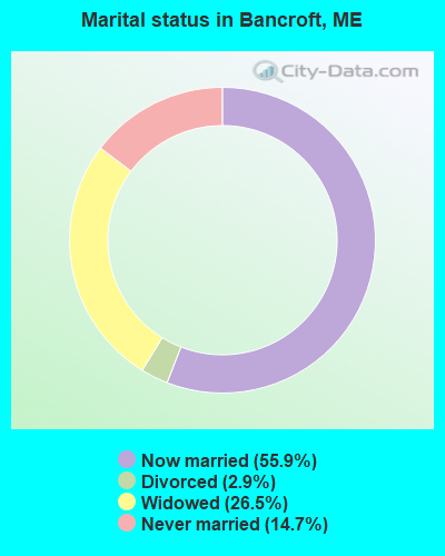
- Never married: 14.7%
- Now married: 55.9%
- Separated: 0.0%
- Widowed: 26.5%
- Divorced: 2.9%
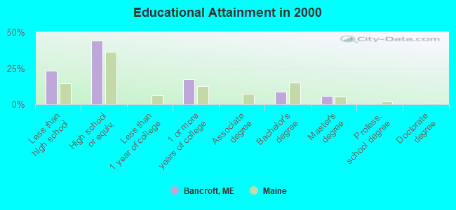
For population 25 years and over in Bancroft:
- High school or higher: 76.5%
- Bachelor's degree or higher: 14.7%
- Graduate or professional degree: 5.9%
- Unemployed: 5.9%
- Mean travel time to work (commute): 22.9 minutes

| Here: | 9.8 |
| Maine average: | 11.2 |


Graphs represent county-level data. Detailed 2008 Election Results
Religion statistics for Bancroft, ME (based on Aroostook County data)


| Religion | Adherents | Congregations |
|---|---|---|
| Catholic | 22,200 | 27 |
| Mainline Protestant | 5,845 | 40 |
| Evangelical Protestant | 4,411 | 51 |
| Other | 957 | 7 |
| Orthodox | 10 | 1 |
| None | 38,447 | - |
Food Environment Statistics:
| Aroostook County: | 4.03 / 10,000 pop. |
| Maine: | 2.80 / 10,000 pop. |
| This county: | 0.14 / 10,000 pop. |
| State: | 0.14 / 10,000 pop. |
| Aroostook County: | 2.22 / 10,000 pop. |
| Maine: | 2.20 / 10,000 pop. |
| Aroostook County: | 7.78 / 10,000 pop. |
| State: | 5.75 / 10,000 pop. |
| Here: | 9.17 / 10,000 pop. |
| State: | 11.02 / 10,000 pop. |
| This county: | 11.7% |
| Maine: | 8.2% |
| Aroostook County: | 27.6% |
| Maine: | 25.0% |
Strongest AM radio stations in Bancroft:
- WREM (710 AM; daytime; 5 kW; MONTICELLO, ME; Owner: ALLAN H WEINER)
- WZON (620 AM; 5 kW; BANGOR, ME; Owner: THE ZONE CORPORATION)
- WFST (600 AM; 5 kW; CARIBOU, ME; Owner: NORTHERN BROADCAST MINISTRIES, INC.)
- WABI (910 AM; 5 kW; BANGOR, ME; Owner: CLEAR CHANNEL BROADCASTING LICENSES, INC.)
- WRKO (680 AM; 50 kW; BOSTON, MA; Owner: ENTERCOM BOSTON LICENSE, LLC)
- WEGP (1390 AM; 5 kW; PRESQUE ISLE, ME; Owner: DECELLES/SMITH MEDIA, INC.)
- WSKW (1160 AM; 10 kW; SKOWHEGAN, ME; Owner: MOUNTAIN WIRELESS, INCORPORATED)
- WEEI (850 AM; 50 kW; BOSTON, MA; Owner: ENTERCOM BOSTON LICENSE, LLC)
- WSYY (1240 AM; 1 kW; MILLINOCKET, ME; Owner: KATAHDIN BROADCASTING, INC.)
- WNNZ (640 AM; 50 kW; WESTFIELD, MA; Owner: CLEAR CHANNEL BROADCASTING LICENSES, INC.)
- WBZ (1030 AM; 50 kW; BOSTON, MA; Owner: INFINITY BROADCASTING OPERATIONS, INC.)
- WCRN (830 AM; 50 kW; WORCESTER, MA; Owner: CARTER BROADCASTING CORPORATION)
- WCHP (760 AM; 35 kW; CHAMPLAIN, NY; Owner: CHAMPLAIN RADIO, INC.)
Strongest FM radio stations in Bancroft:
- WHCF (88.5 FM; BANGOR, ME; Owner: BANGOR BAPTIST CHURCH)
- WVOM (103.9 FM; HOWLAND, ME; Owner: CLEAR CHANNEL BROADCASTING LICENSES, INC.)
- WHOU-FM (100.1 FM; HOULTON, ME; Owner: COUNTY COMMUNICATIONS, INC.)
TV broadcast stations around Bancroft:
- W17BJ (Channel 17; DANFORTH, ME; Owner: TRINITY BROADCASTING NETWORK)
Bancroft fatal accident list:
Jul 11, 1999 03:20 AM, Selden Rd, Vehicles: 1, Persons: 2, Pedestrians: 1, Fatalities: 1, Drunk persons involved: 1
- National Bridge Inventory (NBI) Statistics
- 2Number of bridges
- 23ft / 6.6mTotal length
- 1,259Total average daily traffic
- 62Total average daily truck traffic
- 1,906Total future (year 2036) average daily traffic
Bancroft compared to Maine state average:
- Median household income significantly below state average.
- Median house value significantly below state average.
- Unemployed percentage below state average.
- Black race population percentage significantly below state average.
- Median age significantly above state average.
- Foreign-born population percentage significantly below state average.
- Renting percentage significantly below state average.
- Length of stay since moving in significantly above state average.
- Number of rooms per house significantly below state average.
- House age significantly below state average.
- Number of college students significantly below state average.
- Percentage of population with a bachelor's degree or higher below state average.