Anza-Borrego Springs, California
Submit your own pictures of this place and show them to the world
- OSM Map
- Google Map
- MSN Map
| Males: 1,722 | |
| Females: 1,651 |
| Median resident age: | 48.9 years |
| California median age: | 33.3 years |
Zip code: 92036
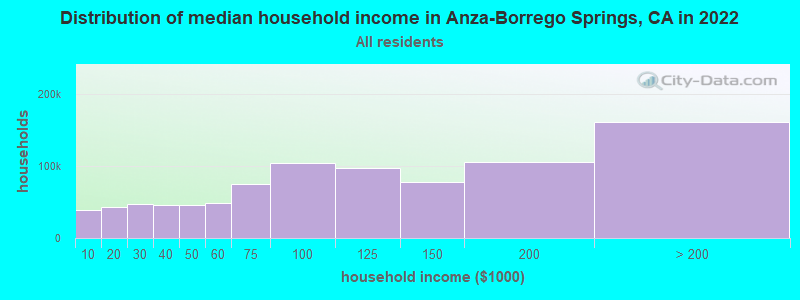
| Anza-Borrego Springs: | $75,005 |
| CA: | $91,551 |
Estimated per capita income in 2022: $43,831 (it was $20,823 in 2000)
Anza-Borrego Springs CCD income, earnings, and wages data
Estimated median house or condo value in 2022: $415,313 (it was $104,000 in 2000)
| Anza-Borrego Springs: | $415,313 |
| CA: | $715,900 |
Mean prices in 2022: all housing units: over $1,000,000; detached houses: over $1,000,000; townhouses or other attached units: $769,037; in 2-unit structures: over $1,000,000; in 3-to-4-unit structures: $948,790; in 5-or-more-unit structures: $697,244; mobile homes: $174,850; occupied boats, rvs, vans, etc.: $27,331
Anza-Borrego Springs, CA residents, houses, and apartments details
Detailed information about poverty and poor residents in Anza-Borrego Springs, CA


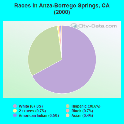
- 2,14567.0%White alone
- 98030.6%Hispanic
- 230.7%Black alone
- 240.7%Two or more races
- 170.5%American Indian alone
- 120.4%Asian alone
- 10.03%Native Hawaiian and Other
Pacific Islander alone - 10.03%Other race alone
 Recent articles from our blog. Our writers, many of them Ph.D. graduates or candidates, create easy-to-read articles on a wide variety of topics.
Current Local Time: PST time zone
Land area: 1068.1 square miles.
Population density: 3.2 people per square mile (very low).
| Anza-Borrego Springs CCD: | 1.0% ($1,042) |
| California: | 0.8% ($1,564) |
Nearest city with pop. 50,000+: Coachella Valley, CA  (37.0 miles , pop. 118,932).
Nearest city with pop. 200,000+: San Diego, CA (54.2 miles , pop. 1,223,400).
Nearest cities:
), ), Latitude: 33.13 N, Longitude: 116.31 W
| Here: | 4.3% |
| California: | 5.1% |
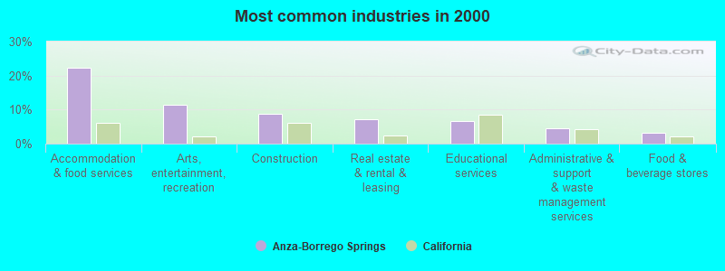
- Accommodation & food services (22.3%)
- Arts, entertainment, recreation (11.4%)
- Construction (8.7%)
- Real estate & rental & leasing (7.1%)
- Educational services (6.6%)
- Administrative & support & waste management services (4.6%)
- Food & beverage stores (3.3%)

- Accommodation & food services (19.1%)
- Arts, entertainment, recreation (14.4%)
- Construction (14.2%)
- Administrative & support & waste management services (6.2%)
- Real estate & rental & leasing (5.9%)
- Educational services (3.7%)
- Food & beverage stores (3.5%)
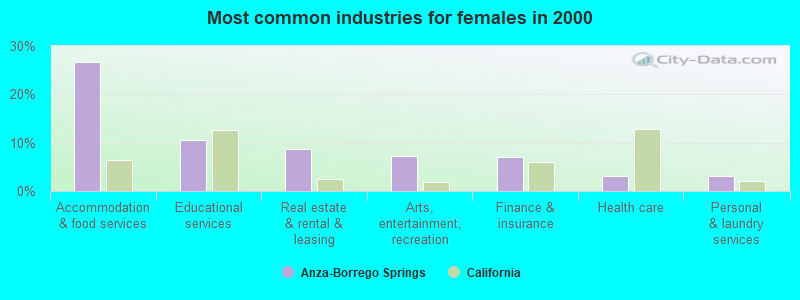
- Accommodation & food services (26.8%)
- Educational services (10.6%)
- Real estate & rental & leasing (8.7%)
- Arts, entertainment, recreation (7.3%)
- Finance & insurance (7.1%)
- Health care (3.1%)
- Personal & laundry services (3.1%)
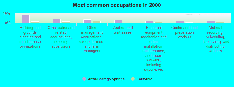
- Building and grounds cleaning and maintenance occupations (13.2%)
- Other sales and related occupations, including supervisors (6.6%)
- Other management occupations, except farmers and farm managers (5.8%)
- Waiters and waitresses (5.5%)
- Electrical equipment mechanics and other installation, maintenance, and repair workers, including supervisors (3.7%)
- Cooks and food preparation workers (3.6%)
- Material recording, scheduling, dispatching, and distributing workers (3.5%)
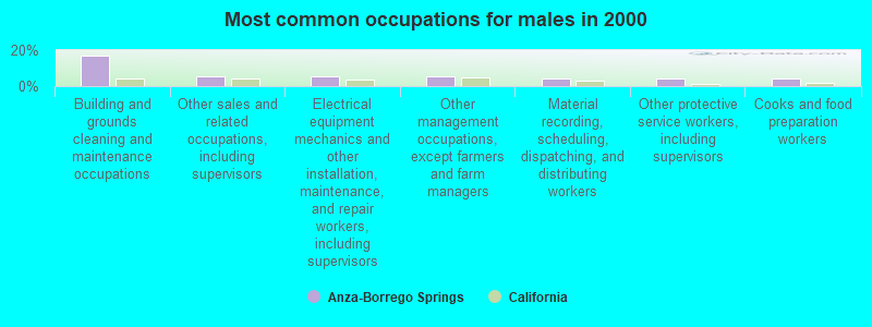
- Building and grounds cleaning and maintenance occupations (17.2%)
- Other sales and related occupations, including supervisors (5.7%)
- Electrical equipment mechanics and other installation, maintenance, and repair workers, including supervisors (5.4%)
- Other management occupations, except farmers and farm managers (5.3%)
- Material recording, scheduling, dispatching, and distributing workers (4.5%)
- Other protective service workers, including supervisors (4.3%)
- Cooks and food preparation workers (4.1%)
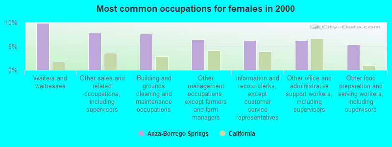
- Waiters and waitresses (9.9%)
- Other sales and related occupations, including supervisors (7.8%)
- Building and grounds cleaning and maintenance occupations (7.7%)
- Other management occupations, except farmers and farm managers (6.4%)
- Information and record clerks, except customer service representatives (6.3%)
- Other office and administrative support workers, including supervisors (6.3%)
- Other food preparation and serving workers, including supervisors (5.4%)
Average climate in Anza-Borrego Springs, California
Based on data reported by over 4,000 weather stations


(lower is better)
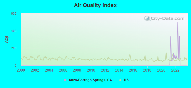
Air Quality Index (AQI) level in 2022 was 201. This is significantly worse than average.
| City: | 201 |
| U.S.: | 73 |
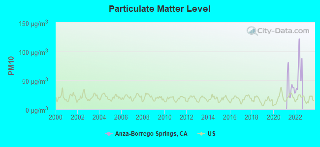
Particulate Matter (PM10) [µg/m3] level in 2022 was 62.6. This is significantly worse than average. Closest monitor was 24.3 miles away from the city center.
| City: | 62.6 |
| U.S.: | 19.2 |
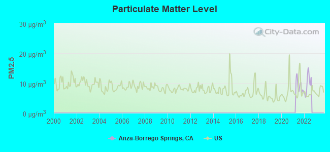
Particulate Matter (PM2.5) [µg/m3] level in 2022 was 9.84. This is worse than average. Closest monitor was 24.3 miles away from the city center.
| City: | 9.84 |
| U.S.: | 8.11 |
Earthquake activity:
Anza-Borrego Springs-area historical earthquake activity is significantly above California state average. It is 6212% greater than the overall U.S. average.On 6/28/1992 at 11:57:34, a magnitude 7.6 (6.2 MB, 7.6 MS, 7.3 MW, Depth: 0.7 mi, Class: Major, Intensity: VIII - XII) earthquake occurred 73.9 miles away from the city center, causing 3 deaths (1 shaking deaths, 2 other deaths) and 400 injuries, causing $100,000,000 total damage and $40,000,000 insured losses
On 5/19/1940 at 04:36:40, a magnitude 7.2 (7.2 UK) earthquake occurred 36.2 miles away from the city center, causing $33,000,000 total damage
On 10/16/1999 at 09:46:44, a magnitude 7.4 (6.3 MB, 7.4 MS, 7.2 MW, 7.3 ML) earthquake occurred 96.0 miles away from the city center
On 12/31/1934 at 18:45:56, a magnitude 7.1 (7.1 UK) earthquake occurred 44.4 miles away from Anza-Borrego Springs center
On 7/21/1952 at 11:52:14, a magnitude 7.7 (7.7 UK) earthquake occurred 201.1 miles away from Anza-Borrego Springs center, causing $50,000,000 total damage
On 10/15/1979 at 23:16:54, a magnitude 7.0 (5.7 MB, 6.9 MS, 7.0 ML, 6.4 MW) earthquake occurred 44.8 miles away from Anza-Borrego Springs center
Magnitude types: body-wave magnitude (MB), local magnitude (ML), surface-wave magnitude (MS), moment magnitude (MW)
Natural disasters:
The number of natural disasters in San Diego County (39) is a lot greater than the US average (15).Major Disasters (Presidential) Declared: 21
Emergencies Declared: 2
Causes of natural disasters: Fires: 21, Floods: 17, Storms: 9, Winter Storms: 6, Landslides: 5, Mudslides: 4, Freeze: 1, Heavy Rain: 1, Hurricane: 1, Tornado: 1, Other: 1 (Note: some incidents may be assigned to more than one category).
Colleges/universities with over 2000 students nearest to Anza-Borrego Springs:
- College of the Desert (about 42 miles; Palm Desert, CA; Full-time enrollment: 5,686)
- Cuyamaca College (about 46 miles; El Cajon, CA; FT enrollment: 4,270)
- Grossmont College (about 46 miles; El Cajon, CA; FT enrollment: 10,461)
- Alliant International University (about 49 miles; San Diego, CA; FT enrollment: 3,155)
- California State University-San Marcos (about 49 miles; San Marcos, CA; FT enrollment: 8,070)
- San Diego Miramar College (about 50 miles; San Diego, CA; FT enrollment: 5,128)
- Palomar College (about 51 miles; San Marcos, CA; FT enrollment: 15,037)
Points of interest:
Notable locations in Anza-Borrego Springs: Borrego Palm Canyon Campground (A), Oliver Ranch (B), Brinniger Ranch (C), Little Borego (D), Desert View Picnic Site (E), Penny Pines Interpretive Site (F), Storm Canyon Vista Trailhead (G), Campbell Ranch (H), Palo Verde Ranger Station (I), Rancho De Anza (J), Crawford Ranch (K), Mountain Palm Springs Campground (L), Seventeen Palms (M), Sheep Canyon Ranger Station (N), Smoke Tree Forest (O), Morteros (P), Sombrero Peak Palm Grove (Q), Blair Valley Campground (R), Yaqui Pass Dry Camp (S), Una Palma (T). Display/hide their locations on the map
Shopping Centers: The Galleria Shopping Center (1), The Plaza Shopping Center (2), The Mall Shopping Center (3). Display/hide their locations on the map
Churches in Anza-Borrego Springs include: Borrego Lutheran Church (A), The Church of Jesus Christ of Latter Day Saints (B), Community United Methodist Church (C), First Baptist Church (D), Saint Barnabas Episcopal Church (E), Saint Richards Catholic Church (F), Seventh Day Adventist Church (G). Display/hide their locations on the map
Lakes, reservoirs, and swamps: Natural Rock Tanks (A), Cuyapaipe Reservoir (B), Sentence Cienaga (C). Display/hide their locations on the map
Streams, rivers, and creeks: Hills of the Moon Wash (A), Fonts Point Wash (B), Fault Wash (C), Ella Wash (D), Chuckwalla Wash (E), Canebrake Wash (F), Camels Head Wash (G), Bow Willow Creek (H), Borrego Sink Wash (I). Display/hide their locations on the map
Parks in Anza-Borrego Springs include: Ocotillo Wells State Vehicular Recreation Area (1), Anza-Borrego Desert State Park (2), Agua Caliente County Park (3), El Vado Historical Marker (4), In-Ko-Pah County Park (5), Los Puertecitos Historical Marker (6), Pegleg Smith Historical Marker (7), Vallecito Stage Station County Park (8), Mountain Springs County Park (9). Display/hide their locations on the map
| This place: | 2.2 people |
| California: | 2.9 people |
| This place: | 51.0% |
| Whole state: | 69.4% |
| This place: | 5.1% |
| Whole state: | 5.9% |
Likely homosexual households (counted as self-reported same-sex unmarried-partner households)
- Lesbian couples: 0.2% of all households
- Gay men: 0.6% of all households
| This place: | 14.6% |
| Whole state: | 14.2% |
| This place: | 3.9% |
| Whole state: | 6.3% |
For population 15 years and over in Anza-Borrego Springs:
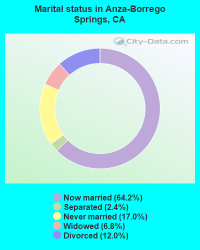
- Never married: 17.0%
- Now married: 64.2%
- Separated: 2.4%
- Widowed: 6.8%
- Divorced: 12.0%
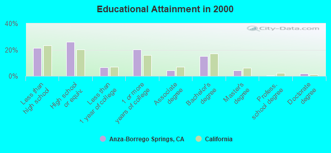
For population 25 years and over in Anza-Borrego Springs:
- High school or higher: 78.7%
- Bachelor's degree or higher: 21.5%
- Graduate or professional degree: 6.4%
- Unemployed: 3.8%
- Mean travel time to work (commute): 20.3 minutes
| Here: | 13.9 |
| California average: | 16.1 |
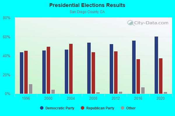
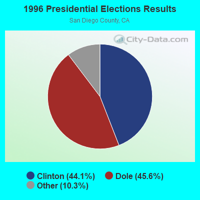
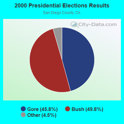
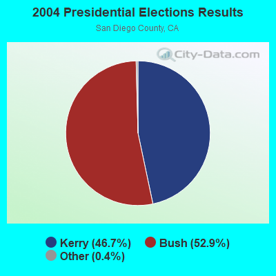
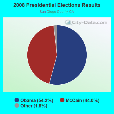
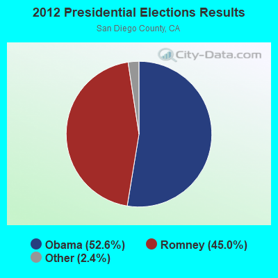
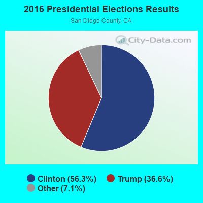
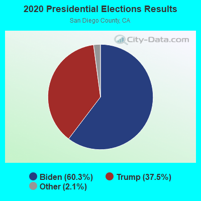
Graphs represent county-level data. Detailed 2008 Election Results
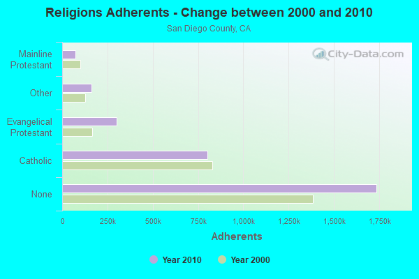
Religion statistics for Anza-Borrego Springs, CA (based on San Diego County data)
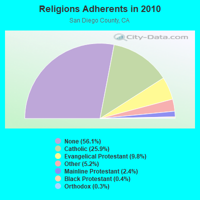
| Religion | Adherents | Congregations |
|---|---|---|
| Catholic | 801,850 | 115 |
| Evangelical Protestant | 302,320 | 974 |
| Other | 161,530 | 349 |
| Mainline Protestant | 74,992 | 211 |
| Black Protestant | 10,857 | 52 |
| Orthodox | 7,828 | 19 |
| None | 1,735,936 | - |
Food Environment Statistics:
| San Diego County: | 1.94 / 10,000 pop. |
| California: | 2.14 / 10,000 pop. |
| San Diego County: | 0.06 / 10,000 pop. |
| California: | 0.04 / 10,000 pop. |
| San Diego County: | 0.77 / 10,000 pop. |
| State: | 0.62 / 10,000 pop. |
| Here: | 1.65 / 10,000 pop. |
| State: | 1.49 / 10,000 pop. |
| This county: | 7.56 / 10,000 pop. |
| State: | 7.42 / 10,000 pop. |
| San Diego County: | 6.5% |
| California: | 7.3% |
| San Diego County: | 22.2% |
| State: | 21.3% |
| San Diego County: | 16.0% |
| California: | 17.9% |
5.18% of this county's 2021 resident taxpayers lived in other counties in 2020 ($90,734 average adjusted gross income)
| Here: | 5.18% |
| California average: | 5.19% |
0.14% of residents moved from foreign countries ($1,493 average AGI)
San Diego County: 0.14% California average: 0.03%
Top counties from which taxpayers relocated into this county between 2020 and 2021:
| from Los Angeles County, CA | |
| from Riverside County, CA | |
| from Orange County, CA |
5.71% of this county's 2020 resident taxpayers moved to other counties in 2021 ($83,556 average adjusted gross income)
| Here: | 5.71% |
| California average: | 6.14% |
0.09% of residents moved to foreign countries ($1,067 average AGI)
San Diego County: 0.09% California average: 0.02%
Top counties to which taxpayers relocated from this county between 2020 and 2021:
| to Riverside County, CA | |
| to Los Angeles County, CA | |
| to Orange County, CA |
Strongest AM radio stations in Anza-Borrego Springs:
- KFMB (760 AM; 50 kW; SAN DIEGO, CA; Owner: MIDWEST TELEVISION, INC.)
- KCBQ (1170 AM; 50 kW; SAN DIEGO, CA; Owner: RADIO 1210, INC.)
- KPLS (830 AM; 50 kW; ORANGE, CA; Owner: CRN LICENSES, LLC)
- KPRZ (1210 AM; 20 kW; SAN MARCOS, CA; Owner: RADIO 1210, INC.)
- KFI (640 AM; 50 kW; LOS ANGELES, CA; Owner: CAPSTAR TX LIMITED PARTNERSHIP)
- KLAC (570 AM; 50 kW; LOS ANGELES, CA; Owner: AMFM RADIO LICENSES, L.L.C.)
- KSDO (1130 AM; 10 kW; SAN DIEGO, CA; Owner: HI-FAVOR BROADCASTING, LLC)
- KTNQ (1020 AM; 50 kW; LOS ANGELES, CA; Owner: KTNQ-AM LICENSE CORP.)
- KECR (910 AM; 5 kW; EL CAJON, CA; Owner: FAMILY STATIONS, INC.)
- KSPN (710 AM; 50 kW; LOS ANGELES, CA; Owner: KABC-AM RADIO, INC.)
- KNWQ (1140 AM; 10 kW; PALM SPRINGS, CA; Owner: MCC RADIO, LLC)
- KXTA (1150 AM; 50 kW; LOS ANGELES, CA; Owner: CITICASTERS LICENSES, L.P.)
- KNWZ (970 AM; 5 kW; COACHELLA, CA; Owner: MCC RADIO, LLC)
Strongest FM radio stations in Anza-Borrego Springs:
- KLVJ (100.1 FM; JULIAN, CA; Owner: EDUCATIONAL MEDIA FOUNDATION)
- KRTM (88.9 FM; TEMECULA, CA; Owner: PENFOLD COMMUNICATIONS, INC.)
- KLRD (90.1 FM; YUCAIPA, CA; Owner: EDUCATIONAL MEDIA FOUNDATION)
- KWVE (107.9 FM; SAN CLEMENTE, CA; Owner: CALVARY CHAPEL OF COSTA MESA)
- KPBS-FM (89.5 FM; SAN DIEGO, CA; Owner: THE BD. OF TRUSTEES, CALIFORNIA STATE UNIVERSITY)
- KHTS-FM (93.3 FM; EL CAJON, CA; Owner: CITICASTERS LICENSES, L.P.)
- KATY-FM (101.3 FM; IDYLLWILD, CA; Owner: ALL PRO BROADCASTING, INC.)
- K210CL (89.9 FM; LEMON GROVE, CA; Owner: SANTA MONICA COMMUNITY COLLEGE DISTRICT)
- K201AR (88.1 FM; BANNING, CA; Owner: KSGN, INC.)
- K232CX (94.3 FM; DESERT HOT SPRINGS, CA; Owner: MCC RADIO, LLC)
- KLQV (102.9 FM; SAN DIEGO, CA; Owner: HBC LICENSE CORPORATION)
- KZAL (105.5 FM; DESERT CENTER, CA; Owner: WORLDWIDE MULTI-MEDIA B/C CO.)
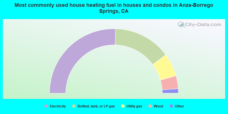
- 50.8%Electricity
- 28.9%Bottled, tank, or LP gas
- 11.6%Utility gas
- 6.5%Wood
- 1.3%Other fuel
- 0.9%Solar energy
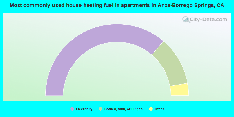
- 72.5%Electricity
- 21.9%Bottled, tank, or LP gas
- 3.1%Wood
- 1.4%No fuel used
- 1.1%Utility gas
Anza-Borrego Springs compared to California state average:
- Median house value below state average.
- Unemployed percentage significantly below state average.
- Black race population percentage significantly below state average.
- Median age significantly above state average.
- Foreign-born population percentage significantly below state average.
- Renting percentage significantly below state average.
- Length of stay since moving in significantly above state average.
- Number of rooms per house significantly below state average.
- House age significantly below state average.
- Number of college students below state average.