Adams, Kentucky
Submit your own pictures of this place and show them to the world
- OSM Map
- General Map
- Google Map
- MSN Map

| Males: 1,600 | |
| Females: 1,534 |
| Median resident age: | 35.5 years |
| Kentucky median age: | 35.9 years |
Zip code: 41230
| Adams: | $36,956 |
| KY: | $59,341 |
Estimated per capita income in 2022: $18,474 (it was $10,339 in 2000)
Adams CCD income, earnings, and wages data
Estimated median house or condo value in 2022: $99,162 (it was $38,600 in 2000)
| Adams: | $99,162 |
| KY: | $196,300 |
Detailed information about poverty and poor residents in Adams, KY
Compare current foreclosures near Adams, KY:
| Photo | Address | Area | Beds / Baths | Price | Details |
|---|---|---|---|---|---|

|
#1
Route 993
Paintsville, KY 41240
|
1,584 sq. feet
|
2 baths 3 beds |
show details | |

|
#2
Ky Route 3224
River, KY 41254
|
1,420 sq. feet
|
2 baths 3 beds |
show details | |

|
#3
Kentucky Rte 3224
River, KY 41254
|
- sq. feet
|
- baths - beds |
$23,900
|
show details |

|
#4
Ky Route 201
Sitka, KY 41255
|
1,932 sq. feet
|
3 baths 5 beds |
show details | |

|
#5
Ky Route 1596
Boons Camp, KY 41204
|
2,510 sq. feet
|
2 baths 3 beds |
show details | |

|
#6
Buffalo Rd
Meally, KY 41234
|
1,672 sq. feet
|
2 baths 3 beds |
show details | |

|
#7
Tug River Rd
Inez, KY 41224
|
1,134 sq. feet
|
1 baths 2 beds |
show details | |

|
#8
Church Dr
Paintsville, KY 41240
|
2,352 sq. feet
|
2 baths 4 beds |
show details | |

|
#9
Crisp Fitzpatrick Pl
Tomahawk, KY 41262
|
1,344 sq. feet
|
1 baths 3 beds |
show details | |

|
#10
Dicey Frk
Meally, KY 41234
|
1,545 sq. feet
|
2 baths 3 beds |
show details |
| Photo | Address | Area | Beds / Baths | Price | Details |
|---|---|---|---|---|---|

|
#11
W Main St
Louisa, KY 41230
|
2,412 sq. feet
|
2 baths 4 beds |
show details | |

|
#12
Murray Dr
Sitka, KY 41255
|
864 sq. feet
|
1 baths 3 beds |
show details | |

|
#13
Old River Rd
Louisa, KY 41230
|
912 sq. feet
|
1 baths 2 beds |
show details | |

|
#14
Clyde Davis Dr
Tomahawk, KY 41262
|
1,232 sq. feet
|
1 baths 3 beds |
show details | |

|
#15
Auxier Ave
Paintsville, KY 41240
|
1,722 sq. feet
|
1 baths 4 beds |
show details | |

|
#16
Rose St
Louisa, KY 41230
|
1,537 sq. feet
|
2 baths 3 beds |
show details | |

|
#17
Red Garden Ln
Louisa, KY 41230
|
1,600 sq. feet
|
1 baths 3 beds |
show details | |

|
#18
Sunset Acres Dr
Louisa, KY 41230
|
1,643 sq. feet
|
2 baths 4 beds |
show details | |

|
#19
Ky Route 993
Paintsville, KY 41240
|
1,536 sq. feet
|
1 baths 3 beds |
show details | |

|
#20
Lyons Dr
Paintsville, KY 41240
|
2,296 sq. feet
|
2 baths 3 beds |
show details |
| Photo | Address | Area | Beds / Baths | Price | Details |
|---|---|---|---|---|---|

|
#21
Jacobs Ln
Warfield, KY 41267
|
1,965 sq. feet
|
1 baths - beds |
show details | |

|
#22
Webb Holw
Van Lear, KY 41265
|
960 sq. feet
|
- baths - beds |
show details | |

|
#23
Ferguson Branch Rd
Dunlow, WV 25511
|
- sq. feet
|
2 baths 4 beds |
show details | |

|
#24
Highway 32
Martha, KY 41159
|
672 sq. feet
|
- baths - beds |
show details | |

|
#25
Ky Route 469
Keaton, KY 41226
|
- sq. feet
|
- baths - beds |
show details | |

|
#26
Ponderosa Dr
Paintsville, KY 41240
|
- sq. feet
|
- baths - beds |
show details | |

|
#27
Hidden Valley Rd Apt 111
Paintsville, KY 41240
|
- sq. feet
|
- baths - beds |
show details | |

|
#28
Court St
Paintsville, KY 41240
|
- sq. feet
|
- baths - beds |
show details | |

|
#29
King Ln
Paintsville, KY 41240
|
2,256 sq. feet
|
- baths - beds |
show details | |

|
#30
Depot Rd
Paintsville, KY 41240
|
- sq. feet
|
- baths - beds |
show details |
| Photo | Address | Area | Beds / Baths | Price | Details |
|---|---|---|---|---|---|

|
#31
Meades Branch Rd
Louisa, KY 41230
|
- sq. feet
|
- baths - beds |
show details | |

|
#32
Main St Apt 5
Paintsville, KY 41240
|
- sq. feet
|
- baths - beds |
show details | |

|
#33
Washington Ave
Paintsville, KY 41240
|
- sq. feet
|
- baths - beds |
show details | |

|
#34
Washington Ave # 12
Paintsville, KY 41240
|
- sq. feet
|
- baths - beds |
show details | |

|
#35
Jefferson Ave
Paintsville, KY 41240
|
- sq. feet
|
- baths - beds |
show details | |

|
#36
Main St Apt 112
Paintsville, KY 41240
|
- sq. feet
|
- baths - beds |
show details | |

|
#37
Wickerfield Rd
Inez, KY 41224
|
- sq. feet
|
- baths - beds |
show details | |

|
#38
Ponderosa Dr
Paintsville, KY 41240
|
- sq. feet
|
- baths - beds |
show details | |

|
#39
Arrowhead Dr
West Van Lear, KY 41268
|
- sq. feet
|
- baths - beds |
show details | |

|
#40
Ky-3214
Flatgap, KY 41219
|
- sq. feet
|
- baths - beds |
show details |
| Photo | Address | Area | Beds / Baths | Price | Details |
|---|---|---|---|---|---|

|
#41
Cherry Hill Ln
Hagerhill, KY 41222
|
- sq. feet
|
- baths - beds |
show details | |

|
#42
Olivene Dr
Inez, KY 41224
|
- sq. feet
|
- baths - beds |
show details | |

|
#43
Millers Crk
Van Lear, KY 41265
|
- sq. feet
|
- baths - beds |
show details | |

|
#44
Win Rd
Oil Springs, KY 41238
|
- sq. feet
|
- baths - beds |
show details | |

|
#45
Johnson Br
Hagerhill, KY 41222
|
1,128 sq. feet
|
- baths - beds |
show details | |

|
#46
Millers Crk
Van Lear, KY 41265
|
- sq. feet
|
- baths - beds |
show details | |

|
#47
Wiley Branch Rd
Martha, KY 41159
|
- sq. feet
|
- baths - beds |
show details | |

|
#48
N Peach St
Thelma, KY 41260
|
- sq. feet
|
- baths - beds |
show details | |

|
#49
Morgan Kirk Loop
Inez, KY 41224
|
- sq. feet
|
- baths - beds |
show details | |

|
Check over 1 million property listings on Foreclosure.com!
|
browse all offers | |||

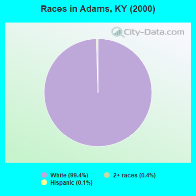
- 2,97599.4%White alone
- 110.4%Two or more races
- 40.1%Hispanic
- 10.03%Black alone
- 10.03%American Indian alone
Races in Adams detailed stats: ancestries, foreign born residents, place of birth
 Recent articles from our blog. Our writers, many of them Ph.D. graduates or candidates, create easy-to-read articles on a wide variety of topics.
Current Local Time: EST time zone
Land area: 89.4 square miles.
Population density: 35 people per square mile (very low).

| Adams CCD: | 0.7% ($273) |
| Kentucky: | 0.8% ($610) |
Nearest city with pop. 50,000+: Huntington, WV  (31.5 miles , pop. 51,475).
Nearest city with pop. 200,000+: Fayette, KY (97.6 miles , pop. 260,512).
Nearest city with pop. 1,000,000+: Chicago, IL (373.9 miles , pop. 2,896,016).
Nearest cities:
), ), ), ), ), Latitude: 38.01 N, Longitude: 82.70 W
Area code commonly used in this area: 606

| Here: | 5.7% |
| Kentucky: | 3.8% |
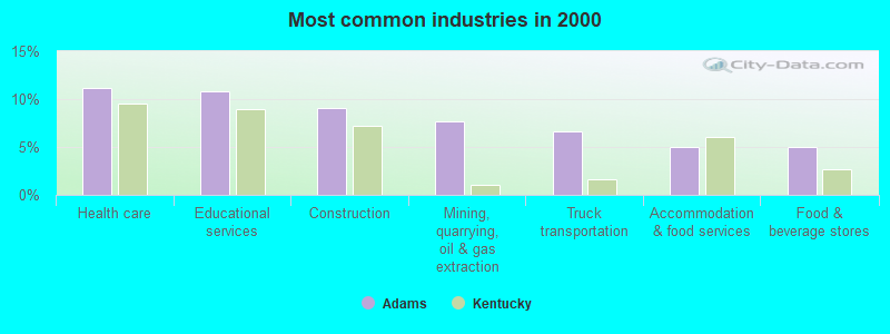
- Health care (11.1%)
- Educational services (10.8%)
- Construction (9.1%)
- Mining, quarrying, oil & gas extraction (7.7%)
- Truck transportation (6.7%)
- Accommodation & food services (5.0%)
- Food & beverage stores (5.0%)
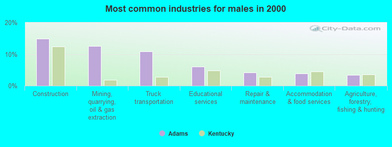
- Construction (14.9%)
- Mining, quarrying, oil & gas extraction (12.5%)
- Truck transportation (10.9%)
- Educational services (6.0%)
- Repair & maintenance (4.2%)
- Accommodation & food services (3.8%)
- Agriculture, forestry, fishing & hunting (3.4%)
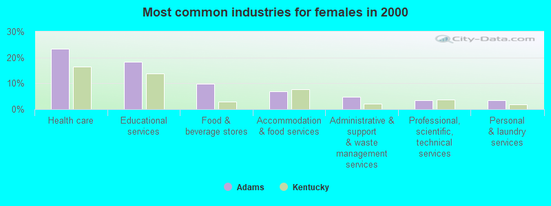
- Health care (23.3%)
- Educational services (18.4%)
- Food & beverage stores (9.8%)
- Accommodation & food services (6.9%)
- Administrative & support & waste management services (4.9%)
- Professional, scientific, technical services (3.5%)
- Personal & laundry services (3.5%)
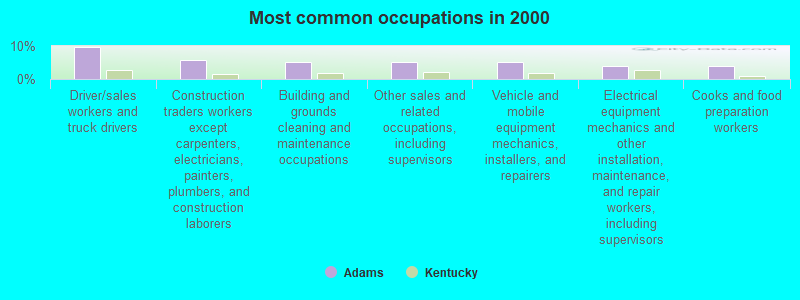
- Driver/sales workers and truck drivers (9.7%)
- Construction traders workers except carpenters, electricians, painters, plumbers, and construction laborers (5.8%)
- Building and grounds cleaning and maintenance occupations (5.1%)
- Other sales and related occupations, including supervisors (5.1%)
- Vehicle and mobile equipment mechanics, installers, and repairers (5.0%)
- Electrical equipment mechanics and other installation, maintenance, and repair workers, including supervisors (3.9%)
- Cooks and food preparation workers (3.9%)
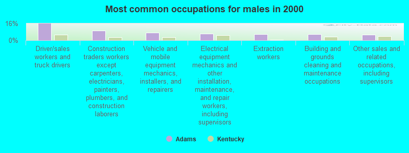
- Driver/sales workers and truck drivers (15.8%)
- Construction traders workers except carpenters, electricians, painters, plumbers, and construction laborers (9.4%)
- Vehicle and mobile equipment mechanics, installers, and repairers (7.2%)
- Electrical equipment mechanics and other installation, maintenance, and repair workers, including supervisors (6.3%)
- Extraction workers (6.0%)
- Building and grounds cleaning and maintenance occupations (5.8%)
- Other sales and related occupations, including supervisors (5.4%)

- Secretaries and administrative assistants (7.5%)
- Preschool, kindergarten, elementary, and middle school teachers (6.3%)
- Health technologists and technicians (6.3%)
- Other office and administrative support workers, including supervisors (6.1%)
- Textile, apparel, and furnishings workers (5.5%)
- Cashiers (5.2%)
- Customer service representatives (4.9%)
Average climate in Adams, Kentucky
Based on data reported by over 4,000 weather stations


(lower is better)
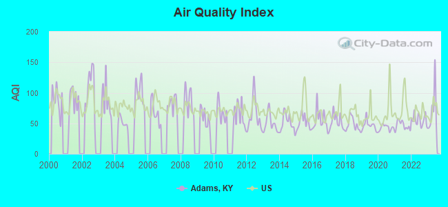
Air Quality Index (AQI) level in 2023 was 69.8. This is about average.
| City: | 69.8 |
| U.S.: | 72.6 |
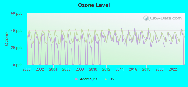
Ozone [ppb] level in 2023 was 36.0. This is about average. Closest monitor was 15.2 miles away from the city center.
| City: | 36.0 |
| U.S.: | 33.3 |
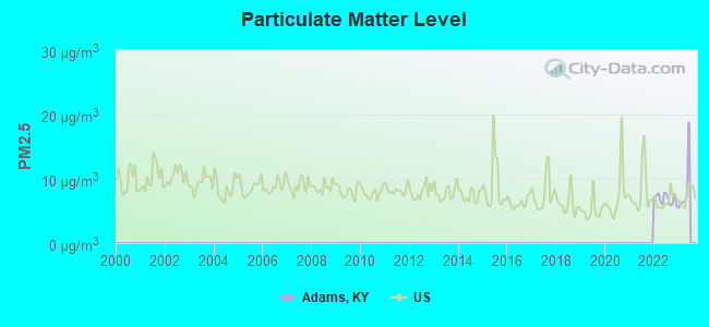
Particulate Matter (PM2.5) [µg/m3] level in 2022 was 6.85. This is about average. Closest monitor was 22.2 miles away from the city center.
| City: | 6.85 |
| U.S.: | 8.11 |
Tornado activity:
Adams-area historical tornado activity is significantly below Kentucky state average. It is 64% smaller than the overall U.S. average.
On 4/23/1968, a category F5 (max. wind speeds 261-318 mph) tornado 48.0 miles away from the Adams place center killed 7 people and injured 93 people and caused between $500,000 and $5,000,000 in damages.
On 4/8/1965, a category F3 (max. wind speeds 158-206 mph) tornado 24.3 miles away from the place center injured 3 people and caused between $50,000 and $500,000 in damages.
Earthquake activity:
Adams-area historical earthquake activity is significantly above Kentucky state average. It is 20% greater than the overall U.S. average.On 7/27/1980 at 18:52:21, a magnitude 5.2 (5.1 MB, 4.7 MS, 5.0 UK, 5.2 UK, Class: Moderate, Intensity: VI - VII) earthquake occurred 68.8 miles away from the city center
On 8/23/2011 at 17:51:04, a magnitude 5.8 (5.8 MW, Depth: 3.7 mi) earthquake occurred 260.0 miles away from Adams center
On 8/9/2020 at 12:07:37, a magnitude 5.1 (5.1 MW, Depth: 4.7 mi) earthquake occurred 138.3 miles away from the city center
On 9/7/1988 at 02:28:09, a magnitude 4.6 (4.5 MB, 4.6 LG, Class: Light, Intensity: IV - V) earthquake occurred 64.6 miles away from the city center
On 4/18/2008 at 09:36:59, a magnitude 5.4 (5.1 MB, 4.8 MS, 5.4 MW, 5.2 MW) earthquake occurred 283.2 miles away from Adams center
On 11/2/2006 at 17:53:02, a magnitude 4.3 (4.3 MB, Depth: 0.6 mi) earthquake occurred 70.6 miles away from the city center
Magnitude types: regional Lg-wave magnitude (LG), body-wave magnitude (MB), surface-wave magnitude (MS), moment magnitude (MW)
Natural disasters:
The number of natural disasters in Lawrence County (38) is a lot greater than the US average (15).Major Disasters (Presidential) Declared: 29
Emergencies Declared: 3
Causes of natural disasters: Floods: 27, Storms: 25, Tornadoes: 12, Mudslides: 11, Landslides: 8, Winter Storms: 7, Winds: 4, Fires: 2, Snowstorms: 2, Blizzard: 1, Freeze: 1, Hurricane: 1, Snow: 1, Snowfall: 1, Other: 1 (Note: some incidents may be assigned to more than one category).
Colleges/universities with over 2000 students nearest to Adams:
- Big Sandy Community and Technical College (about 23 miles; Prestonsburg, KY; Full-time enrollment: 2,660)
- Ashland Community and Technical College (about 32 miles; Ashland, KY; FT enrollment: 2,482)
- Marshall University (about 33 miles; Huntington, WV; FT enrollment: 11,450)
- Morehead State University (about 42 miles; Morehead, KY; FT enrollment: 7,523)
- Shawnee State University (about 53 miles; Portsmouth, OH; FT enrollment: 4,160)
- West Virginia State University (about 57 miles; Institute, WV; FT enrollment: 2,133)
- Hazard Community and Technical College (about 60 miles; Hazard, KY; FT enrollment: 2,087)
Points of interest:
Notable location: Lowmansville Volunteer Fire Department (A). Display/hide its location on the map
Churches in Adams include: Marys United Baptist Church (A), Mattie Church (B), Meade Branch Church (C), Moores Chapel (D), Little Blaine United Baptist Church (E), Evergreen Methodist Church (F), Cordell Freewill Baptist Church (G), Noris Church (H), Emmanuel Baptist Church (I). Display/hide their locations on the map
Cemeteries: Prince Cemetery (1), Carter Cemetery (2), Hayes Cemetery (3), Cordle Cemetery (4), Busseyville United Methodist Church Cemetery (5), Emerson-Stratton Cemetery (6), Shannon Cemetery (7). Display/hide their locations on the map
Streams, rivers, and creeks: Aaron Branch (A), Amos Thompson Branch (B), Arrington Branch (C), Ash Branch (D), Ashhopper Branch (E), Beasley Branch (F), Berry Branch (G), Biggs Branch (H), Birch Branch (I). Display/hide their locations on the map
| This place: | 2.5 people |
| Kentucky: | 2.5 people |
| This place: | 72.6% |
| Whole state: | 66.9% |
| This place: | 5.2% |
| Whole state: | 6.4% |
Likely homosexual households (counted as self-reported same-sex unmarried-partner households)
- Lesbian couples: 0.3% of all households
- Gay men: 0.3% of all households
| This place: | 27.5% |
| Whole state: | 15.8% |
| This place: | 10.3% |
| Whole state: | 6.6% |
For population 15 years and over in Adams:
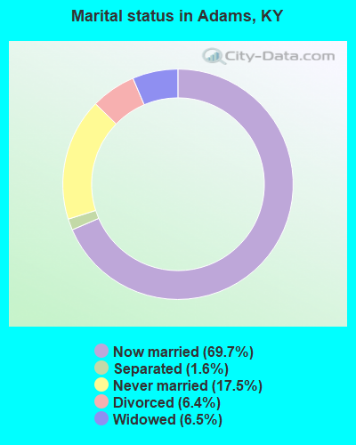
- Never married: 17.5%
- Now married: 69.7%
- Separated: 1.6%
- Widowed: 6.5%
- Divorced: 6.4%
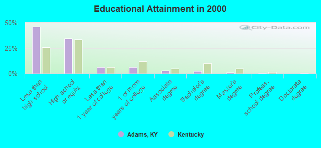
For population 25 years and over in Adams:
- High school or higher: 54.1%
- Bachelor's degree or higher: 4.0%
- Graduate or professional degree: 1.6%
- Unemployed: 13.0%
- Mean travel time to work (commute): 33.4 minutes
| Here: | 15.1 |
| Kentucky average: | 13.8 |
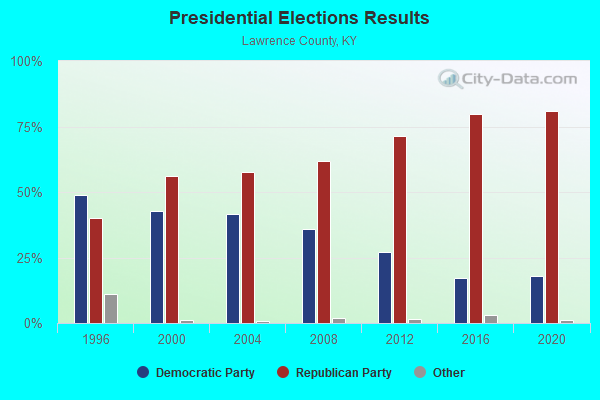
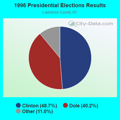
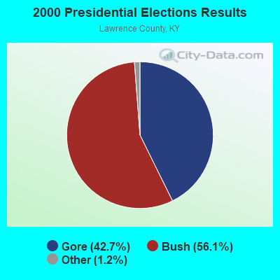
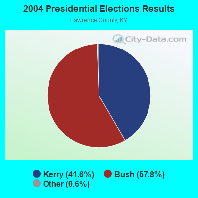
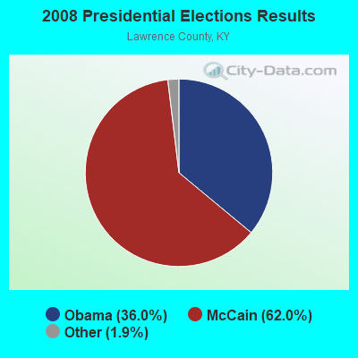
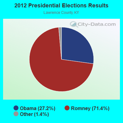
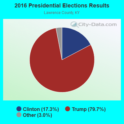
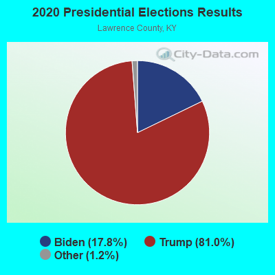
Graphs represent county-level data. Detailed 2008 Election Results
Religion statistics for Adams, KY (based on Lawrence County data)
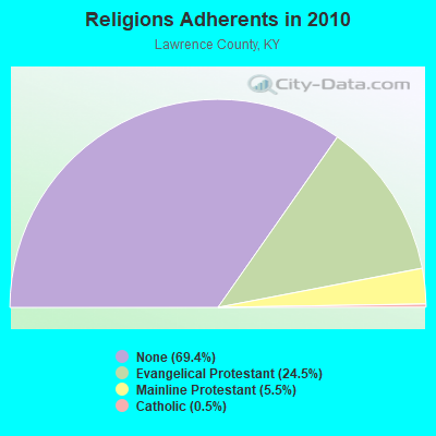
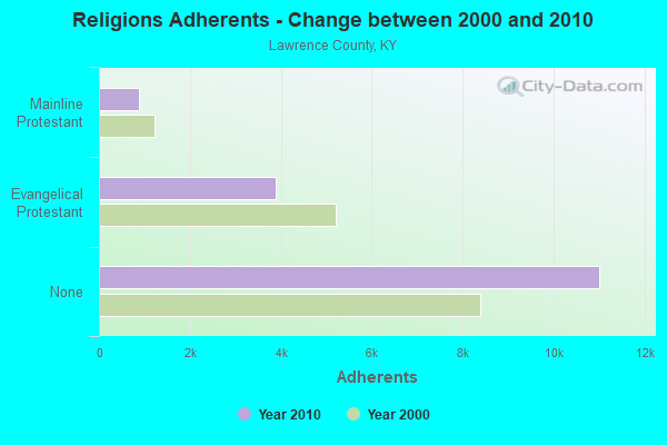
| Religion | Adherents | Congregations |
|---|---|---|
| Evangelical Protestant | 3,892 | 34 |
| Mainline Protestant | 870 | 8 |
| Catholic | 86 | 1 |
| Other | 1 | 1 |
| None | 11,011 | - |
Food Environment Statistics:
| Lawrence County: | 2.45 / 10,000 pop. |
| Kentucky: | 2.19 / 10,000 pop. |
| This county: | 0.61 / 10,000 pop. |
| State: | 0.25 / 10,000 pop. |
| Lawrence County: | 1.23 / 10,000 pop. |
| Kentucky: | 0.74 / 10,000 pop. |
| Lawrence County: | 7.97 / 10,000 pop. |
| State: | 4.36 / 10,000 pop. |
| Here: | 2.45 / 10,000 pop. |
| State: | 5.74 / 10,000 pop. |
| This county: | 11.6% |
| Kentucky: | 11.0% |
| Lawrence County: | 32.6% |
| Kentucky: | 30.0% |
| This county: | 21.6% |
| State: | 15.9% |
Strongest AM radio stations in Adams:
- WKYH (600 AM; 5 kW; PAINTSVILLE, KY; Owner: HIGHLANDS BROADCASTING CORPORATION)
- WPRT (960 AM; 5 kW; PRESTONSBURG, KY; Owner: EAST KENTUCKY RADIO NETWORK, INC.)
- WDOC (1310 AM; 5 kW; PRESTONSBURG, KY)
- WVHU (800 AM; 5 kW; HUNTINGTON, WV; Owner: CAPSTAR TX LIMITED PARTNERSHIP)
- WTVN (610 AM; 50 kW; COLUMBUS, OH; Owner: CITICASTERS LICENSES, L.P.)
- WRVC (930 AM; 5 kW; HUNTINGTON, WV; Owner: FIFTH AVENUE BROADCASTING COMPANY, INC.)
- WGOH (1370 AM; 5 kW; GRAYSON, KY; Owner: CARTER COUNTY BROADCASTING CO., INC.)
- WTCR (1420 AM; 5 kW; KENOVA, WV; Owner: CAPSTAR TX LIMITED PARTNERSHIP)
- WLW (700 AM; 50 kW; CINCINNATI, OH; Owner: JACOR BROADCASTING CORPORATION)
- WHRD (1470 AM; 5 kW; HUNTINGTON, WV; Owner: CONCORD MEDIA GROUP, INC.)
- WOKT (1040 AM; daytime; 2 kW; CANNONSBURG, KY; Owner: BIG RIVER RADIO, INC.-KY)
- WSIP (1490 AM; 1 kW; PAINTSVILLE, KY; Owner: S.I.P. BROADCASTING COMPANY, INC.)
- WCAW (680 AM; 10 kW; CHARLESTON, WV; Owner: WEST VIRGINIA RADIO CORPORATION OF CHARLESTON)
Strongest FM radio stations in Adams:
- WKLW-FM (94.7 FM; PAINTSVILLE, KY; Owner: B & G BROADCASTING, INC.)
- WQHY (95.5 FM; PRESTONSBURG, KY; Owner: WDOC, INC.)
- WSIP-FM (98.9 FM; PAINTSVILLE, KY; Owner: SIP BROADCASTING, INC.)
- WZAQ (92.3 FM; LOUISA, KY; Owner: LOUISA COMMUNICATIONS, INC.)
- WDGG (93.7 FM; ASHLAND, KY; Owner: FIFTH AVENUE B/CASTING COMPANY, INC.)
- WFGH (90.7 FM; FORT GAY, WV; Owner: WAYNE COUNTY BOARD OF EDUCATION)
- WKLC-FM (105.1 FM; ST. ALBANS, WV; Owner: WKLC, INC.)
- WXLR (104.9 FM; HAROLD, KY; Owner: ADAM D GEARHEART)
- WPAY-FM (104.1 FM; PORTSMOUTH, OH; Owner: RADIO STATIONS WPAY/WPFB, INC.)
- WVWV (89.9 FM; HUNTINGTON, WV; Owner: WEST VIRGINIA EDUCATIONAL BROADCASTING AUTHORITY)
- WAMX (106.3 FM; MILTON, WV; Owner: CAPSTAR TX LIMITED PARTNERSHIP)
- WMKY (90.3 FM; MOREHEAD, KY; Owner: MOREHEAD STATE UNIVERSITY)
- WDHR (93.1 FM; PIKEVILLE, KY; Owner: EAST KENTUCKY BROADCASTING CORP.)
- WVKM (106.7 FM; MATEWAN, WV; Owner: THREE STATES BROADCASTING CO., INC.)
- WBKS (107.1 FM; IRONTON, OH; Owner: CAPSTAR TX LIMITED PARTNERSHIP)
- WKEE-FM (100.5 FM; HUNTINGTON, WV; Owner: CAPSTAR TX LIMITED PARTNERSHIP)
- WMDJ-FM (100.1 FM; ALLEN, KY; Owner: FLOYD COUNTY BROADCASTING CO., INC.)
- WRVC-FM (92.7 FM; CATLETTSBURG, KY; Owner: FIFTH AVENUE BROADCASTING CO., INC)
- WXKZ-FM (105.3 FM; PRESTONSBURG, KY; Owner: ADAM GEARHEART D/B/A WXLR-FM)
- WUGO (102.3 FM; GRAYSON, KY; Owner: CARTER COUNTY BROADCASTING CO., INC.)
TV broadcast stations around Adams:
- WVAH-TV (Channel 11; CHARLESTON, WV; Owner: WVAH LICENSEE, LLC)
- WPBY-TV (Channel 33; HUNTINGTON, WV; Owner: WEST VIRGINIA EDUCATIONAL BROADCASTING AUTHORITY)
- WSAZ-TV (Channel 3; HUNTINGTON, WV; Owner: EMMIS TELEVISION LICENSE CORPORATION)
- WCHS-TV (Channel 8; CHARLESTON, WV; Owner: WCHS LICENSEE, LLC)
- WOWK-TV (Channel 13; HUNTINGTON, WV; Owner: WEST VIRGINIA MEDIA HOLDINGS, LLC)
- W26BK (Channel 26; TALBERT, KY; Owner: MS COMMUNICATIONS, LLC)
- WUPX-TV (Channel 67; MOREHEAD, KY; Owner: PAXSON LEXINGTON LICENSE, INC.)
FCC Registered Cell Phone Towers:
1 (See the full list of FCC Registered Cell Phone Towers in Adams)FCC Registered Antenna Towers:
18 (See the full list of FCC Registered Antenna Towers)FCC Registered Microwave Towers:
1- LOUISA, 3.1 Km East Southeast Of (Lat: 38.033889 Lon: -82.661389), Type: Gtower, Structure height: 91.4 m, Overall height: 95.7 m, Call Sign: WQQD488,
Assigned Frequencies: 6345.49 MHz, Grant Date: 11/07/2012, Expiration Date: 11/07/2022, Cancellation Date: 10/18/2022, Certifier: Gerald F Robinette, Registrant: East Kentucky Network, 201 Technology Trail, Ivel, KY 41642, Phone: (606) 794-5254, Fax: (606) 794-4836, Email:
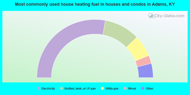
- 55.8%Electricity
- 19.8%Bottled, tank, or LP gas
- 12.1%Utility gas
- 4.5%Wood
- 3.4%Coal or coke
- 3.0%Fuel oil, kerosene, etc.
- 1.5%Other fuel
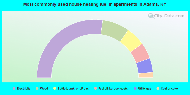
- 54.2%Electricity
- 15.1%Wood
- 10.8%Bottled, tank, or LP gas
- 9.0%Fuel oil, kerosene, etc.
- 7.8%Utility gas
- 3.0%Coal or coke
Adams compared to Kentucky state average:
- Median household income below state average.
- Median house value below state average.
- Black race population percentage significantly below state average.
- Hispanic race population percentage significantly below state average.
- Median age below state average.
- Foreign-born population percentage significantly below state average.
- Renting percentage below state average.
- Length of stay since moving in significantly above state average.
- Number of rooms per house significantly below state average.
- House age significantly below state average.
- Number of college students below state average.
- Percentage of population with a bachelor's degree or higher significantly below state average.
Adams on our top lists:
- #95 on the list of "Top 100 least racially diverse cities"
- #63 on the list of "Top 101 counties with the smallest number of people without health insurance coverage in 2000"
- #78 on the list of "Top 101 counties with the smallest number of children under 18 without health insurance coverage in 2000"