Bridge Statistics for York, Nebraska (NE)
Condition, Traffic, Stress, Structural Evaluation, Project Costs
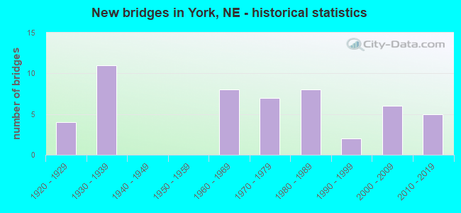
- New bridges - historical statistics
- 41920-1929
- 111930-1939
- 81960-1969
- 71970-1979
- 81980-1989
- 21990-1999
- 62000-2009
- 52010-2019
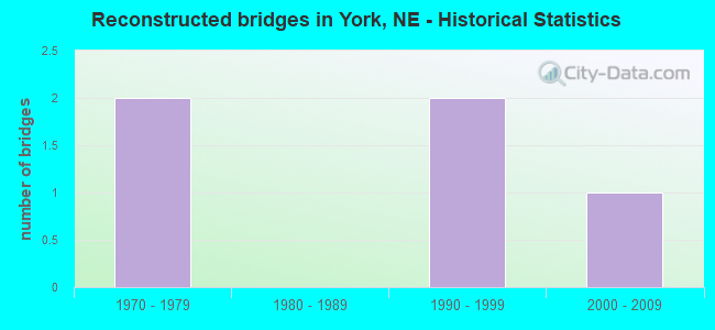
- Reconstructed bridges - Historical Statistics
- 21970-1979
- 01980-1989
- 21990-1999
- 12000-2009
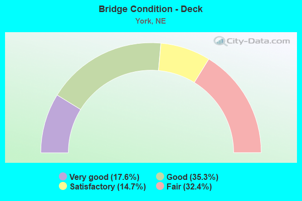
- Bridge Condition - Deck
- 17.6%Very good
- 35.3%Good
- 14.7%Satisfactory
- 32.4%Fair
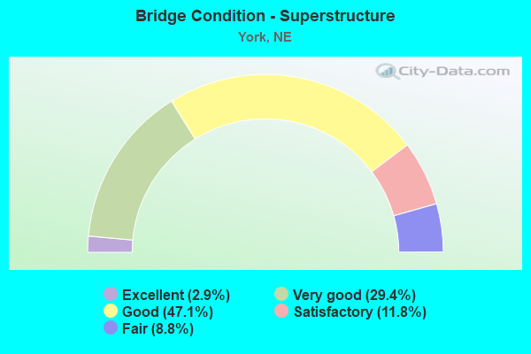
- Bridge Condition - Superstructure
- 2.9%Excellent
- 29.4%Very good
- 47.1%Good
- 11.8%Satisfactory
- 8.8%Fair
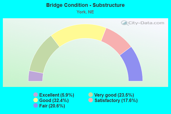
- Bridge Condition - Substructure
- 5.9%Excellent
- 23.5%Very good
- 32.4%Good
- 17.6%Satisfactory
- 20.6%Fair
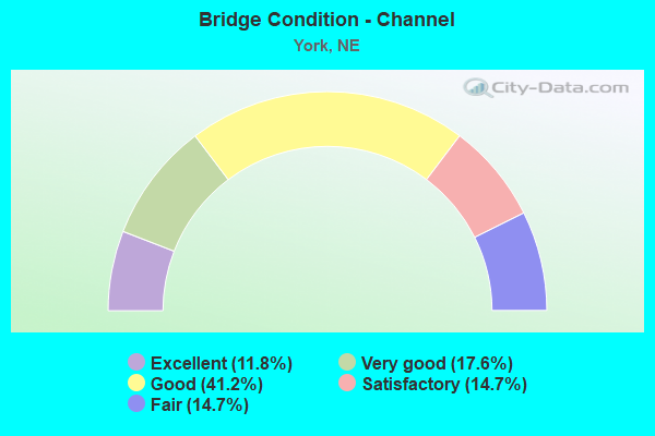
- Bridge Condition - Channel
- 11.8%Excellent
- 17.6%Very good
- 41.2%Good
- 14.7%Satisfactory
- 14.7%Fair
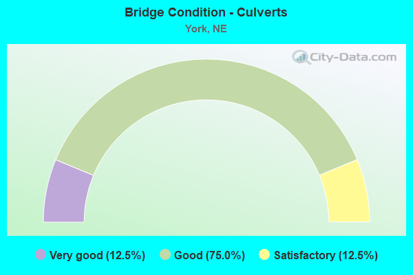
- Bridge Condition - Culverts
- 12.5%Very good
- 75.0%Good
- 12.5%Satisfactory
Find on map >> Show street view
Structure Number: S080 35113, Location: 2W YORK INTRCHG (Lat: 40.821100, Lng: -97.635700), Route carried "under" structure: Interstate 80, Year Built: 1966, Structure Length: 0. m, Average Daily Traffic: 22,155 (year 2013), Truck Traffic: 34%, Features Intersected: I80, Facility Carried by Structure: COUNTY HIGHWAY
Minimum Vertical Clearance: 4.95m (16.24ft), Kilometerpoint: 56.509, Lanes on structure: 4, Lanes under structure: 4, Material/Design: Prestressed concrete continuous, Design/Construction: Stringer/Multi-beam, Length of Maximum Span: 21.3m (69.9ft)
Find on map >> Show street view
Structure Number: S080 35213, Location: 1W YORK INTRCHG (Lat: 40.821100, Lng: -97.616600), Route carried "under" structure: Interstate 80, Year Built: 1966, Structure Length: 0. m, Average Daily Traffic: 22,155 (year 2013), Truck Traffic: 34%, Features Intersected: I80, Facility Carried by Structure: COUNTY HIGHWAY
Minimum Vertical Clearance: 4.90m (16.08ft), Kilometerpoint: 56.670, Lanes on structure: 4, Lanes under structure: 4, Material/Design: Prestressed concrete continuous, Design/Construction: Stringer/Multi-beam, Length of Maximum Span: 21.3m (69.9ft)
Find on map >> Show street view
Structure Number: S080 35312, Location: YORK INTRCHG (Lat: 40.821100, Lng: -97.597800), Route carried "under" structure: Interstate 80, Year Built: 1977, Structure Length: 0. m, Average Daily Traffic: 24,120 (year 2013), Truck Traffic: 33%, Features Intersected: I80, Facility Carried by Structure: SB-US81
Minimum Vertical Clearance: 4.87m (15.98ft), Kilometerpoint: 56.829, Lanes on structure: 4, Lanes under structure: 4, Material/Design: Prestressed concrete continuous, Design/Construction: Stringer/Multi-beam, Length of Maximum Span: 21.3m (69.9ft)
Find on map >> Show street view
Structure Number: S080 35313, Location: YORK INTRCHG (Lat: 40.821100, Lng: -97.597500), Route carried "under" structure: Interstate 80, Year Built: 1966, Structure Length: 0. m, Average Daily Traffic: 24,120 (year 2013), Truck Traffic: 33%, Features Intersected: I80, Facility Carried by Structure: NB-US81
Minimum Vertical Clearance: 5.00m (16.40ft), Kilometerpoint: 56.831, Lanes on structure: 4, Lanes under structure: 4, Material/Design: Prestressed concrete continuous, Design/Construction: Stringer/Multi-beam, Length of Maximum Span: 21.3m (69.9ft)
Find on map >> Show street view
Structure Number: S080 35415, Location: 1E YORK INTRCHG (Lat: 40.821800, Lng: -97.577900), Route carried "under" structure: Interstate 80, Year Built: 1966, Structure Length: 0. m, Average Daily Traffic: 24,120 (year 2013), Truck Traffic: 33%, Features Intersected: I80, Facility Carried by Structure: COUNTY HIGHWAY
Minimum Vertical Clearance: 4.92m (16.14ft), Kilometerpoint: 56.995, Lanes on structure: 4, Lanes under structure: 4, Material/Design: Prestressed concrete, Design/Construction: Stringer/Multi-beam, Length of Maximum Span: 21.3m (69.9ft)
Find on map >> Show street view
Structure Number: U269506204, Location: IN YORK (Lat: 40.873900, Lng: -97.593000), Route carried "under" structure: City street , Year Built: 1938, Structure Length: 0. m, Average Daily Traffic: 3,300 (year 2006), Truck Traffic: 21%, Features Intersected: LINCOLN AVE, Facility Carried by Structure: 14TH ST
Minimum Vertical Clearance: 4.19m (13.75ft), Kilometerpoint: 0.000, Lanes on structure: 2, Lanes under structure: 2, Material/Design: Concrete, Design/Construction: Frame, Length of Maximum Span: 10.1m (33.1ft)
Find on map >> Show street view
Structure Number: U269506205, Location: IN YORK (Lat: 40.874200, Lng: -97.592500), Route carried "under" structure: Ramp City street 610, Year Built: 1938, Structure Length: 0. m, Average Daily Traffic: 3,300 (year 2006), Truck Traffic: 21%, Features Intersected: BNSF RR 073-644-D, Facility Carried by Structure: BNSF RR
Minimum Vertical Clearance: 4.24m (13.91ft), Kilometerpoint: 0.000, Lanes on structure: 2, Lanes under structure: 2, Material/Design: Steel, Design/Construction: Stringer/Multi-beam, Length of Maximum Span: 10.1m (33.1ft)
Find on map >> Show street view
Structure Number: U269506208, Location: IN YORK (Lat: 40.874500, Lng: -97.593000), Route carried "under" structure: City street , Year Built: 1938, Structure Length: 0. m, Average Daily Traffic: 3,300 (year 2006), Truck Traffic: 21%, Features Intersected: LINCOLN AVE, Facility Carried by Structure: 15TH ST
Minimum Vertical Clearance: 4.19m (13.75ft), Kilometerpoint: 0.000, Lanes on structure: 2, Lanes under structure: 2, Material/Design: Concrete, Design/Construction: Frame, Length of Maximum Span: 10.1m (33.1ft)
Find on map >> Show street view
Structure Number: U2695F2505, Location: YORK NEBRASKA AVE @ 16TH (Lat: 40.874800, Lng: -97.590200), Route carried "under" structure: City street 6305, Year Built: 1935, Structure Length: 0. m, Average Daily Traffic: 1,585 (year 2007), Features Intersected: BNSF RR 073-645-K, Facility Carried by Structure: BNSF RR
Minimum Vertical Clearance: 4.31m (14.14ft), Kilometerpoint: 16.206, Lanes on structure: 2, Lanes under structure: 2, Material/Design: Steel, Design/Construction: Stringer/Multi-beam, Length of Maximum Span: 10.1m (33.1ft)