Bridge Statistics for Woodworth, Louisiana (LA)
Condition, Traffic, Stress, Structural Evaluation, Project Costs
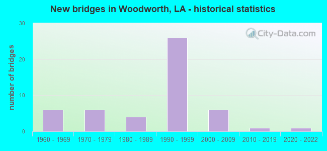
- New bridges - historical statistics
- 61960-1969
- 61970-1979
- 41980-1989
- 261990-1999
- 62000-2009
- 12010-2019
- 12020-2022


- Bridge Condition - Deck
- 2.2%Excellent
- 68.9%Good
- 28.9%Satisfactory

- Bridge Condition - Superstructure
- 2.2%Excellent
- 73.3%Good
- 24.4%Satisfactory

- Bridge Condition - Substructure
- 51.1%Good
- 37.8%Satisfactory
- 4.4%Fair
- 4.4%Poor
- 2.2%Serious

- Bridge Condition - Channel
- 2.1%Excellent
- 44.7%Good
- 42.6%Satisfactory
- 6.4%Fair
- 2.1%Poor
- 2.1%Serious

- Bridge Condition - Culverts
- 60.0%Good
- 20.0%Satisfactory
- 20.0%Fair
Find on map >> Show street view
Structure Number: 80602000002201, Location: NO DATA ENTERED (Lat: 31.182956, Lng: -92.519447), Route carried "on" structure: Federal lands road 208.1, Year Built: 1977, Status: Open, Structure Length: 1.58m (5.18ft), Average Daily Traffic: 10 (year 1981), Average Future Daily Traffic: 15 (year 2042), Design Load: HS 20, Features Intersected: ODEN BRANCH, Facility Carried by Structure: FDR 208
Minimum Vertical Clearance: 30+ m (98+ ft), Kilometerpoint: 1.700, Lanes on structure: 1, Owner: U.S. Forest Service, Approaching Roadway Width: 5.2m (17.1ft), Material/Design: Prestressed concrete, Design/Construction: Channel Beam, Number Of Spans In Main Unit: 3, Length of Maximum Span: 5.3m (17.4ft), Curb-To-Curb Width: 4.6m (15.1ft), Out-to-Out Width: 5.1m (16.7ft)
Condition: Deck: Satisfactory, Superstructure: Good, Substructure: Fair, Channel: Fair, Operating Rating: 23.3 metric tons, Method Used To Determine Operating Rating: Load and Resistance Factor Rating (LRFR) rating reported by rating factor(RF) method using HL-93 loadings, Inventory Rating: 15.2 metric tons, Method Used To Determine Inventory Rating: Load and Resistance Factor Rating (LRFR) rating reported by rating factor(RF) method using HL-93 loadings, Structural Evaluation: Meets minimum limits, Deck Geometry: Better than present minimum criteria, Waterway Adequacy: Equal to present desirable criteria, Approach Roadway Alignment: Equal to present desirable criteria, Designated Inspection Frequency: Every 24 months, Inspection Date: March 2021, Deck Structure Type: Other, Wearing Surface/Protective System: Wearing Surface: Integral Concrete
Find on map >> Show street view
Structure Number: 80602000002221, Location: NO DATA ENTERED (Lat: 31.122258, Lng: -92.543492), Route carried "on" structure: Federal lands road 247.3, Year Built: 1970, Status: Open, Structure Length: 0.98m (3.22ft), Average Daily Traffic: 30 (year 1976), Average Future Daily Traffic: 45 (year 2042), Design Load: HS 20, Features Intersected: BAYOU CLEAR, Facility Carried by Structure: FDR 247
Minimum Vertical Clearance: 30+ m (98+ ft), Kilometerpoint: 5.619, Lanes on structure: 1, Owner: U.S. Forest Service, Approaching Roadway Width: 5.5m (18.0ft), Material/Design: Prestressed concrete, Design/Construction: Channel Beam, Number Of Spans In Main Unit: 2, Length of Maximum Span: 4.9m (16.1ft), Curb or Sidewalk Widths: Left: 0.1m (0.3ft), Right: 0.1m (0.3ft), Curb-To-Curb Width: 4.6m (15.1ft), Out-to-Out Width: 5.1m (16.7ft)
Condition: Deck: Good, Superstructure: Good, Substructure: Good, Channel: Satisfactory, Operating Rating: 27.9 metric tons, Method Used To Determine Operating Rating: Load and Resistance Factor Rating (LRFR) rating reported by rating factor(RF) method using HL-93 loadings, Inventory Rating: 20.1 metric tons, Method Used To Determine Inventory Rating: Load and Resistance Factor Rating (LRFR) rating reported by rating factor(RF) method using HL-93 loadings, Structural Evaluation: Somewhat better than minimum adequacy, Deck Geometry: Better than present minimum criteria, Waterway Adequacy: Equal to present minimum criteria, Approach Roadway Alignment: Better than present minimum criteria, Designated Inspection Frequency: Every 24 months, Inspection Date: March 2021, Deck Structure Type: Other, Wearing Surface/Protective System: Wearing Surface: Integral Concrete
Find on map >> Show street view
Structure Number: 80602000002223, Location: NO DATA ENTERED (Lat: 31.128600, Lng: -92.549392), Route carried "on" structure: Federal lands road 247.3, Year Built: 1970, Status: Open, Structure Length: 1.89m (6.20ft), Average Daily Traffic: 30 (year 1976), Average Future Daily Traffic: 45 (year 2042), Design Load: HS 20, Features Intersected: NORTH FORK BAYOU CLEAR, Facility Carried by Structure: FDR 247
Minimum Vertical Clearance: 30+ m (98+ ft), Kilometerpoint: 5.937, Lanes on structure: 1, Owner: U.S. Forest Service, Approaching Roadway Width: 5.8m (19.0ft), Material/Design: Prestressed concrete, Design/Construction: Channel Beam, Number Of Spans In Main Unit: 3, Length of Maximum Span: 6.4m (21.0ft), Curb or Sidewalk Widths: Left: 0.2m (0.7ft), Right: 0.2m (0.7ft), Curb-To-Curb Width: 4.6m (15.1ft), Out-to-Out Width: 5.1m (16.7ft)
Condition: Deck: Good, Superstructure: Satisfactory, Substructure: Good, Channel: Satisfactory, Operating Rating: 24.9 metric tons, Method Used To Determine Operating Rating: Load and Resistance Factor Rating (LRFR) rating reported by rating factor(RF) method using HL-93 loadings, Inventory Rating: 17.8 metric tons, Method Used To Determine Inventory Rating: Load and Resistance Factor Rating (LRFR) rating reported by rating factor(RF) method using HL-93 loadings, Structural Evaluation: Somewhat better than minimum adequacy, Deck Geometry: Better than present minimum criteria, Waterway Adequacy: Equal to present minimum criteria, Approach Roadway Alignment: Better than present minimum criteria, Designated Inspection Frequency: Every 24 months, Inspection Date: March 2021, Deck Structure Type: Other, Wearing Surface/Protective System: Wearing Surface: Integral Concrete
Find on map >> Show street view
Structure Number: 80602000002225, Location: NO DATA ENTERED (Lat: 31.169078, Lng: -92.526489), Route carried "on" structure: Federal lands road 249.1, Year Built: 1970, Status: Open, Structure Length: 1.07m (3.51ft), Average Daily Traffic: 60 (year 1976), Average Future Daily Traffic: 50 (year 2020), Design Load: H 20, Features Intersected: LITTLE BAYOU CLEAR, Facility Carried by Structure: FDR 249
Minimum Vertical Clearance: 30+ m (98+ ft), Kilometerpoint: 2.620, Lanes on structure: 1, Owner: U.S. Forest Service, Approaching Roadway Width: 6.1m (20.0ft), Material/Design: Wood or Timber, Design/Construction: Stringer/Multi-beam, Number Of Spans In Main Unit: 2, Length of Maximum Span: 5.5m (18.0ft), Curb or Sidewalk Widths: Left: 0.2m (0.7ft), Right: 0.2m (0.7ft), Curb-To-Curb Width: 4.3m (14.1ft), Out-to-Out Width: 4.9m (16.1ft)
Condition: Deck: Satisfactory, Superstructure: Satisfactory, Substructure: Good, Channel: Satisfactory, Operating Rating: 29.2 metric tons, Method Used To Determine Operating Rating: Load and Resistance Factor Rating (LRFR) rating reported by rating factor(RF) method using HL-93 loadings, Inventory Rating: 22.4 metric tons, Method Used To Determine Inventory Rating: Load and Resistance Factor Rating (LRFR) rating reported by rating factor(RF) method using HL-93 loadings, Structural Evaluation: Equal to present minimum criteria, Deck Geometry: Equal to present minimum criteria, Waterway Adequacy: Better than present minimum criteria, Approach Roadway Alignment: Equal to present desirable criteria, Length Of Structure Improvement: 1.06m (3.48ft), Designated Inspection Frequency: Every 24 months, Inspection Date: March 2021, Bridge Improvement Cost: $20,000,000, Total Project Cost: $20,000,000, Deck Structure Type: Wood or Timber
Find on map >> Show street view
Structure Number: 80602000002255, Location: NATIONAL FOREST ROAD (Lat: 31.203267, Lng: -92.577511), Route carried "on" structure: Federal lands road 287.6, Year Built: 1975, Status: Open, Structure Length: 1.58m (5.18ft), Average Daily Traffic: 60 (year 1976), Average Future Daily Traffic: 90 (year 2042), Design Load: HS 20, Features Intersected: LOVING CREEK, Facility Carried by Structure: FDR 287
Minimum Vertical Clearance: 30+ m (98+ ft), Kilometerpoint: 10.473, Lanes on structure: 2, Owner: U.S. Forest Service, Approaching Roadway Width: 7.0m (23.0ft), Material/Design: Prestressed concrete, Design/Construction: Channel Beam, Number Of Spans In Main Unit: 3, Length of Maximum Span: 6.1m (20.0ft), Curb or Sidewalk Widths: Left: 0.1m (0.3ft), Right: 0.1m (0.3ft), Curb-To-Curb Width: 7.1m (23.3ft), Out-to-Out Width: 7.6m (24.9ft)
Condition: Deck: Satisfactory, Superstructure: Satisfactory, Substructure: Satisfactory, Channel: Satisfactory, Operating Rating: 25.6 metric tons, Method Used To Determine Operating Rating: Load and Resistance Factor Rating (LRFR) rating reported by rating factor(RF) method using HL-93 loadings, Inventory Rating: 18.1 metric tons, Method Used To Determine Inventory Rating: Load and Resistance Factor Rating (LRFR) rating reported by rating factor(RF) method using HL-93 loadings, Structural Evaluation: Somewhat better than minimum adequacy, Deck Geometry: Somewhat better than minimum adequacy, Waterway Adequacy: Better than present minimum criteria, Approach Roadway Alignment: Equal to present desirable criteria, Designated Inspection Frequency: Every 24 months, Inspection Date: March 2021, Deck Structure Type: Other, Wearing Surface/Protective System: Wearing Surface: Integral Concrete
Find on map >> Show street view
Structure Number: 80602000002256, Location: NATIONAL FOREST ROAD (Lat: 31.204047, Lng: -92.578561), Route carried "on" structure: Federal lands road 287.6, Year Built: 1963, Status: Open, Structure Length: 1.86m (6.10ft), Average Daily Traffic: 60 (year 1976), Average Future Daily Traffic: 90 (year 2042), Design Load: HS 20, Features Intersected: LOVING CREEK, Facility Carried by Structure: FDR 287
Minimum Vertical Clearance: 30+ m (98+ ft), Kilometerpoint: 10.604, Lanes on structure: 2, Owner: U.S. Forest Service, Approaching Roadway Width: 6.7m (22.0ft), Material/Design: Prestressed concrete, Design/Construction: Channel Beam, Number Of Spans In Main Unit: 3, Length of Maximum Span: 6.4m (21.0ft), Curb or Sidewalk Widths: Left: 0.1m (0.3ft), Right: 0.1m (0.3ft), Curb-To-Curb Width: 7.1m (23.3ft), Out-to-Out Width: 7.6m (24.9ft)
Condition: Deck: Satisfactory, Superstructure: Satisfactory, Substructure: Satisfactory, Channel: Satisfactory, Operating Rating: 24.9 metric tons, Method Used To Determine Operating Rating: Load and Resistance Factor Rating (LRFR) rating reported by rating factor(RF) method using HL-93 loadings, Inventory Rating: 17.8 metric tons, Method Used To Determine Inventory Rating: Load and Resistance Factor Rating (LRFR) rating reported by rating factor(RF) method using HL-93 loadings, Structural Evaluation: Somewhat better than minimum adequacy, Deck Geometry: Somewhat better than minimum adequacy, Waterway Adequacy: Better than present minimum criteria, Approach Roadway Alignment: Equal to present desirable criteria, Designated Inspection Frequency: Every 24 months, Inspection Date: March 2021, Deck Structure Type: Other, Wearing Surface/Protective System: Wearing Surface: Integral Concrete
Find on map >> Show street view
Structure Number: 80602000002257, Location: NATIONAL FOREST ROAD (Lat: 31.205728, Lng: -92.583122), Route carried "on" structure: County highway 287.7, Year Built: 1963, Status: Open, Structure Length: 2.62m (8.60ft), Average Daily Traffic: 60 (year 1976), Average Future Daily Traffic: 90 (year 2042), Design Load: H 20, Features Intersected: BRANCH CREEK, Facility Carried by Structure: FDR 287
Minimum Vertical Clearance: 30+ m (98+ ft), Kilometerpoint: 11.084, Lanes on structure: 2, Owner: U.S. Forest Service, Approaching Roadway Width: 7.6m (24.9ft), Material/Design: Prestressed concrete, Design/Construction: Channel Beam, Number Of Spans In Main Unit: 4, Length of Maximum Span: 6.6m (21.7ft), Curb or Sidewalk Widths: Left: 0.1m (0.3ft), Right: 0.1m (0.3ft), Curb-To-Curb Width: 7.1m (23.3ft), Out-to-Out Width: 7.6m (24.9ft)
Condition: Deck: Satisfactory, Superstructure: Good, Substructure: Poor, Channel: Fair, Operating Rating: 21.4 metric tons, Method Used To Determine Operating Rating: Load and Resistance Factor Rating (LRFR) rating reported by rating factor(RF) method using HL-93 loadings, Inventory Rating: 13.0 metric tons, Method Used To Determine Inventory Rating: Load and Resistance Factor Rating (LRFR) rating reported by rating factor(RF) method using HL-93 loadings, Structural Evaluation: Meets minimum limits, Deck Geometry: Somewhat better than minimum adequacy, Waterway Adequacy: Better than present minimum criteria, Approach Roadway Alignment: Equal to present desirable criteria, Designated Inspection Frequency: Every 24 months, Inspection Date: March 2021, Deck Structure Type: Other, Wearing Surface/Protective System: Wearing Surface: Integral Concrete
Find on map >> Show street view
Structure Number: 80602000002258, Location: NATIONAL FOREST ROAD (Lat: 31.205833, Lng: -92.583950), Route carried "on" structure: County highway 287.7, Year Built: 1963, Status: Open, Structure Length: 2.62m (8.60ft), Average Daily Traffic: 60 (year 1976), Average Future Daily Traffic: 90 (year 2042), Design Load: H 20, Features Intersected: BRANCH CREEK, Facility Carried by Structure: FDR 287
Minimum Vertical Clearance: 30+ m (98+ ft), Kilometerpoint: 11.163, Lanes on structure: 2, Owner: U.S. Forest Service, Approaching Roadway Width: 7.3m (24.0ft), Material/Design: Prestressed concrete, Design/Construction: Channel Beam, Number Of Spans In Main Unit: 4, Length of Maximum Span: 6.6m (21.7ft), Curb or Sidewalk Widths: Left: 0.1m (0.3ft), Right: 0.1m (0.3ft), Curb-To-Curb Width: 7.1m (23.3ft), Out-to-Out Width: 7.6m (24.9ft)
Condition: Deck: Satisfactory, Superstructure: Satisfactory, Substructure: Serious, Channel: Satisfactory, Operating Rating: 21.4 metric tons, Method Used To Determine Operating Rating: Load and Resistance Factor Rating (LRFR) rating reported by rating factor(RF) method using HL-93 loadings, Inventory Rating: 13.0 metric tons, Method Used To Determine Inventory Rating: Load and Resistance Factor Rating (LRFR) rating reported by rating factor(RF) method using HL-93 loadings, Structural Evaluation: High priority of corrective action, Deck Geometry: Somewhat better than minimum adequacy, Waterway Adequacy: Better than present minimum criteria, Approach Roadway Alignment: Equal to present desirable criteria, Designated Inspection Frequency: Every 24 months, Inspection Date: March 2021, Deck Structure Type: Other, Wearing Surface/Protective System: Wearing Surface: Integral Concrete
Find on map >> Show street view
Structure Number: 80602000002259, Location: NATIONAL FOREST ROAD (Lat: 31.206033, Lng: -92.585572), Route carried "on" structure: County highway 287.7, Year Built: 1962, Status: Open, Structure Length: 1.07m (3.51ft), Average Daily Traffic: 100 (year 2003), Average Future Daily Traffic: 150 (year 2042), Design Load: H 20, Features Intersected: LONG BRANCH OVERFLO, Facility Carried by Structure: FDR 287
Minimum Vertical Clearance: 30+ m (98+ ft), Kilometerpoint: 11.332, Lanes on structure: 2, Owner: U.S. Forest Service, Approaching Roadway Width: 7.0m (23.0ft), Material/Design: Wood or Timber, Design/Construction: Stringer/Multi-beam, Number Of Spans In Main Unit: 2, Length of Maximum Span: 5.3m (17.4ft), Curb or Sidewalk Widths: Left: 0.2m (0.7ft), Right: 0.2m (0.7ft), Curb-To-Curb Width: 6.7m (22.0ft), Out-to-Out Width: 7.3m (24.0ft)
Condition: Deck: Satisfactory, Superstructure: Good, Substructure: Satisfactory, Channel: Poor, Operating Rating: 31.4 metric tons, Method Used To Determine Operating Rating: Load and Resistance Factor Rating (LRFR) rating reported by rating factor(RF) method using HL-93 loadings, Inventory Rating: 24.3 metric tons, Method Used To Determine Inventory Rating: Load and Resistance Factor Rating (LRFR) rating reported by rating factor(RF) method using HL-93 loadings, Structural Evaluation: Equal to present minimum criteria, Deck Geometry: Somewhat better than minimum adequacy, Waterway Adequacy: Better than present minimum criteria, Approach Roadway Alignment: Equal to present desirable criteria, Designated Inspection Frequency: Every 24 months, Inspection Date: March 2021, Deck Structure Type: Wood or Timber
Find on map >> Show street view
Structure Number: 8060200000226, Location: NATIONAL FOREST ROAD (Lat: 31.206992, Lng: -92.591642), Route carried "on" structure: County highway 287.7, Year Built: 1963, Status: Open, Structure Length: 1.40m (4.59ft), Average Daily Traffic: 60 (year 1976), Average Future Daily Traffic: 90 (year 2042), Design Load: HS 20, Features Intersected: CASTOR CREEK, Facility Carried by Structure: FDR 587
Minimum Vertical Clearance: 30+ m (98+ ft), Kilometerpoint: 11.910, Lanes on structure: 2, Owner: U.S. Forest Service, Approaching Roadway Width: 7.3m (24.0ft), Material/Design: Prestressed concrete, Design/Construction: Channel Beam, Number Of Spans In Main Unit: 2, Length of Maximum Span: 7.0m (23.0ft), Curb or Sidewalk Widths: Left: 0.1m (0.3ft), Right: 0.1m (0.3ft), Curb-To-Curb Width: 7.1m (23.3ft), Out-to-Out Width: 7.6m (24.9ft)
Condition: Deck: Satisfactory, Superstructure: Satisfactory, Substructure: Satisfactory, Channel: Serious, Operating Rating: 20.7 metric tons, Method Used To Determine Operating Rating: Load and Resistance Factor Rating (LRFR) rating reported by rating factor(RF) method using HL-93 loadings, Inventory Rating: 12.6 metric tons, Method Used To Determine Inventory Rating: Load and Resistance Factor Rating (LRFR) rating reported by rating factor(RF) method using HL-93 loadings, Structural Evaluation: Meets minimum limits, Deck Geometry: Somewhat better than minimum adequacy, Waterway Adequacy: Better than present minimum criteria, Approach Roadway Alignment: Equal to present desirable criteria, Designated Inspection Frequency: Every 24 months, Inspection Date: March 2021, Deck Structure Type: Other, Wearing Surface/Protective System: Wearing Surface: Integral Concrete
Find on map >> Show street view
Structure Number: 80602000002261, Location: NATIONAL FOREST ROAD (Lat: 31.207586, Lng: -92.592367), Route carried "on" structure: County highway 287.7, Year Built: 1963, Status: Open, Structure Length: 2.62m (8.60ft), Average Daily Traffic: 60 (year 1976), Average Future Daily Traffic: 90 (year 2042), Design Load: HS 20, Features Intersected: CASTOR CREEK, Facility Carried by Structure: FDR 287
Minimum Vertical Clearance: 30+ m (98+ ft), Kilometerpoint: 12.006, Lanes on structure: 2, Owner: U.S. Forest Service, Approaching Roadway Width: 7.9m (25.9ft), Material/Design: Prestressed concrete, Design/Construction: Channel Beam, Number Of Spans In Main Unit: 4, Length of Maximum Span: 6.6m (21.7ft), Curb or Sidewalk Widths: Left: 0.1m (0.3ft), Right: 0.1m (0.3ft), Curb-To-Curb Width: 7.1m (23.3ft), Out-to-Out Width: 7.6m (24.9ft)
Condition: Deck: Satisfactory, Superstructure: Satisfactory, Substructure: Satisfactory, Channel: Satisfactory, Operating Rating: 21.4 metric tons, Method Used To Determine Operating Rating: Load and Resistance Factor Rating (LRFR) rating reported by rating factor(RF) method using HL-93 loadings, Inventory Rating: 13.0 metric tons, Method Used To Determine Inventory Rating: Load and Resistance Factor Rating (LRFR) rating reported by rating factor(RF) method using HL-93 loadings, Structural Evaluation: Meets minimum limits, Deck Geometry: Somewhat better than minimum adequacy, Waterway Adequacy: Better than present minimum criteria, Approach Roadway Alignment: Equal to present desirable criteria, Designated Inspection Frequency: Every 24 months, Inspection Date: March 2021, Deck Structure Type: Other, Wearing Surface/Protective System: Wearing Surface: Integral Concrete
Find on map >> Show street view
Structure Number: 84000000080013, Location: 1.5 M W OF US 165 (Lat: 31.153500, Lng: -92.519439), Route carried "on" structure: County highway , Year Built: 2021, Status: Open, Structure Length: 3.05m (10.01ft), Average Daily Traffic: 100 (year 2019), Average Future Daily Traffic: 390 (year 2038), Design Load: Greater than HL93, Features Intersected: LITTLE BAYOU CLEAR, Facility Carried by Structure: CASTOR PLUNGE RD
Minimum Vertical Clearance: 30+ m (98+ ft), Kilometerpoint: 11.180, Lanes on structure: 2, Owner: Town or Township Highway Agency, Approaching Roadway Width: 5.4m (17.7ft), Material/Design: Concrete, Design/Construction: Slab, Number Of Spans In Main Unit: 5, Length of Maximum Span: 6.1m (20.0ft), Curb-To-Curb Width: 7.1m (23.3ft), Out-to-Out Width: 8.1m (26.6ft)
Condition: Deck: Excellent, Superstructure: Excellent, Substructure: Good, Channel: Excellent, Operating Rating: 56.4 metric tons, Method Used To Determine Operating Rating: Load and Resistance Factor Rating (LRFR) rating reported by rating factor(RF) method using HL-93 loadings, Inventory Rating: 43.4 metric tons, Method Used To Determine Inventory Rating: Load and Resistance Factor Rating (LRFR) rating reported by rating factor(RF) method using HL-93 loadings, Structural Evaluation: Better than present minimum criteria, Deck Geometry: Somewhat better than minimum adequacy, Waterway Adequacy: Superior to present desirable criteria, Approach Roadway Alignment: Superior to present desirable criteria, Designated Inspection Frequency: Every 24 months, Inspection Date: January 2022, Deck Structure Type: Concrete Cast-file-Place
Find on map >> Show street view
Structure Number: 84000000600356, Location: 1.2 MI SOUTH OF LA 470 (Lat: 31.138481, Lng: -92.424400), Route carried "on" structure: County highway , Year Built: 2012, Status: Open, Structure Length: 1.28m (4.20ft), Average Daily Traffic: 80 (year 1976), Average Future Daily Traffic: 104 (year 2036), Design Load: HS 20, Features Intersected: BAYOU LAMOURIE, Facility Carried by Structure: Chickamaw Rd
Minimum Vertical Clearance: 30+ m (98+ ft), Kilometerpoint: 0.175, Lanes on structure: 2, Owner: County Highway Agency, Approaching Roadway Width: 5.2m (17.1ft), Skew: 37 degrees, Material/Design: Steel, Design/Construction: Culvert, Number Of Spans In Main Unit: 3, Length of Maximum Span: 3.0m (9.8ft), Curb-To-Curb Width: 5.4m (17.7ft), Out-to-Out Width: 16.3m (53.5ft)
Condition: Channel: Satisfactory, Culverts: Good, Operating Rating: 56.7 metric tons, Method Used To Determine Operating Rating: Load and Resistance Factor Rating (LRFR) rating reported by rating factor(RF) method using HL-93 loadings, Inventory Rating: 43.7 metric tons, Method Used To Determine Inventory Rating: Load and Resistance Factor Rating (LRFR) rating reported by rating factor(RF) method using HL-93 loadings, Structural Evaluation: Better than present minimum criteria, Deck Geometry: High priority of corrective action, Waterway Adequacy: Equal to present minimum criteria, Approach Roadway Alignment: Equal to present minimum criteria, Designated Inspection Frequency: Every 24 months, Inspection Date: November 2021, Deck Structure Type: Other
Find on map >> Show street view
Structure Number: 84000080909901, Location: 0.39 MI. NORTH OF LA 3170 (Lat: 31.187811, Lng: -92.420100), Route carried "on" structure: US 71, Year Built: 1973, Status: Open, Structure Length: 1.37m (4.49ft), Average Daily Traffic: 16,000 (year 2016), Truck Traffic: 15%, Average Future Daily Traffic: 20,410 (year 2036), Design Load: HS 20, Features Intersected: DRAINAGE DITCH
Minimum Vertical Clearance: 30+ m (98+ ft), Kilometerpoint: 15.933, Lanes on structure: 6, Base Highway Network: Yes (Inventory Route: 8-09-1, Subroute: 10), Owner: State Highway Agency, Approaching Roadway Width: 31.4m (103.0ft), Skew: 33 degrees, Material/Design: Steel, Design/Construction: Culvert, Number Of Spans In Main Unit: 3, Length of Maximum Span: 3.4m (11.2ft)
Condition: Channel: Fair, Culverts: Satisfactory, Operating Rating: 97.2 metric tons, Method Used To Determine Operating Rating: Load and Resistance Factor Rating (LRFR) rating reported by rating factor(RF) method using HL-93 loadings, Inventory Rating: 74.5 metric tons, Method Used To Determine Inventory Rating: Load and Resistance Factor Rating (LRFR) rating reported by rating factor(RF) method using HL-93 loadings, Structural Evaluation: Equal to present minimum criteria, Waterway Adequacy: Somewhat better than minimum adequacy, Approach Roadway Alignment: Equal to present desirable criteria, Designated Inspection Frequency: Every 24 months, Inspection Date: March 2020
Find on map >> Show street view
Structure Number: 84000140600441, Location: 1.7 M N OF JCT. LA 112 (Lat: 31.099331, Lng: -92.511700), Route carried "on" structure: US 165, Year Built: 1991, Status: Open, Structure Length: 4.27m (14.01ft), Average Daily Traffic: 4,100 (year 2016), Truck Traffic: 15%, Average Future Daily Traffic: 6,240 (year 2036), Design Load: HS 20, Features Intersected: INDIAN CREEK
Minimum Vertical Clearance: 30+ m (98+ ft), Kilometerpoint: 0.705, Lanes on structure: 1, Base Highway Network: Yes (Inventory Route: 14-06-1, Subroute: 10), Owner: State Highway Agency, Approaching Roadway Width: 13.4m (44.0ft), Skew: 30 degrees, Material/Design: Concrete, Design/Construction: Slab, Number Of Spans In Main Unit: 7, Length of Maximum Span: 6.1m (20.0ft), Curb-To-Curb Width: 13.4m (44.0ft), Out-to-Out Width: 14.3m (46.9ft)
Condition: Deck: Good, Superstructure: Good, Substructure: Good, Channel: Good, Operating Rating: 72.6 metric tons, Method Used To Determine Operating Rating: Load Factor (LF), Inventory Rating: 43.5 metric tons, Method Used To Determine Inventory Rating: Load Factor (LF), Structural Evaluation: Better than present minimum criteria, Deck Geometry: Better than present minimum criteria, Waterway Adequacy: Equal to present minimum criteria, Approach Roadway Alignment: Better than present minimum criteria, Designated Inspection Frequency: Every 24 months, Inspection Date: August 2020, Deck Structure Type: Concrete Cast-file-Place, Wearing Surface/Protective System: Wearing Surface: Monolithic Concrete
Find on map >> Show street view
Structure Number: 84000140600442, Location: 1.7 M N OF N JCT. LA 112 (Lat: 31.099350, Lng: -92.512200), Route carried "on" structure: US 165, Year Built: 2005, Status: Open, Structure Length: 4.21m (13.81ft), Average Daily Traffic: 4,100 (year 2016), Truck Traffic: 15%, Average Future Daily Traffic: 6,240 (year 2036), Design Load: HS 20, Features Intersected: INDIAN CREEK
Minimum Vertical Clearance: 30+ m (98+ ft), Kilometerpoint: 20.696, Lanes on structure: 2, Base Highway Network: Yes (Inventory Route: 14-06-2, Subroute: 10), Owner: State Highway Agency, Approaching Roadway Width: 11.6m (38.1ft), Skew: 30 degrees, Material/Design: Concrete, Design/Construction: Slab, Number Of Spans In Main Unit: 7, Length of Maximum Span: 6.1m (20.0ft), Curb-To-Curb Width: 11.8m (38.7ft), Out-to-Out Width: 12.8m (42.0ft)
Condition: Deck: Good, Superstructure: Good, Substructure: Good, Channel: Good, Operating Rating: 32.1 metric tons, Method Used To Determine Operating Rating: Load and Resistance Factor Rating (LRFR) rating reported by rating factor(RF) method using HL-93 loadings, Inventory Rating: 24.6 metric tons, Method Used To Determine Inventory Rating: Load and Resistance Factor Rating (LRFR) rating reported by rating factor(RF) method using HL-93 loadings, Structural Evaluation: Equal to present minimum criteria, Deck Geometry: Better than present minimum criteria, Waterway Adequacy: Equal to present desirable criteria, Approach Roadway Alignment: Equal to present desirable criteria, Designated Inspection Frequency: Every 24 months, Inspection Date: August 2020, Deck Structure Type: Concrete Cast-file-Place, Wearing Surface/Protective System: Wearing Surface: Monolithic Concrete
Find on map >> Show street view
Structure Number: 84000140603431, Location: 0.47 MI. SOUTH OF LA 3265 (Lat: 31.140731, Lng: -92.497900), Route carried "on" structure: US 165, Year Built: 1994, Status: Open, Structure Length: 6.10m (20.01ft), Average Daily Traffic: 8,200 (year 2016), Truck Traffic: 15%, Average Future Daily Traffic: 10,400 (year 2036), Design Load: HS 20, Features Intersected: BAYOU CLEAR
Minimum Vertical Clearance: 30+ m (98+ ft), Kilometerpoint: 5.481, Lanes on structure: 4, Base Highway Network: Yes (Inventory Route: 14-06-1, Subroute: 10), Owner: State Highway Agency, Approaching Roadway Width: 26.8m (87.9ft), Skew: 30 degrees, Material/Design: Concrete, Design/Construction: Slab, Number Of Spans In Main Unit: 10, Length of Maximum Span: 6.1m (20.0ft), Curb-To-Curb Width: 24.4m (80.1ft), Out-to-Out Width: 27.7m (90.9ft)
Condition: Deck: Satisfactory, Superstructure: Satisfactory, Substructure: Satisfactory, Channel: Satisfactory, Operating Rating: 68.0 metric tons, Method Used To Determine Operating Rating: Load Factor (LF), Inventory Rating: 39.9 metric tons, Method Used To Determine Inventory Rating: Load Factor (LF), Structural Evaluation: Equal to present minimum criteria, Deck Geometry: Superior to present desirable criteria, Waterway Adequacy: Better than present minimum criteria, Approach Roadway Alignment: Equal to present desirable criteria, Designated Inspection Frequency: Every 24 months, Inspection Date: August 2020, Deck Structure Type: Concrete Cast-file-Place, Wearing Surface/Protective System: Wearing Surface: Monolithic Concrete
Find on map >> Show street view
Structure Number: 84000140604561, Location: 0.66 MI. NORTH OF LA 3265 (Lat: 31.156750, Lng: -92.498700), Route carried "on" structure: US 165, Year Built: 1994, Status: Open, Structure Length: 3.66m (12.01ft), Average Daily Traffic: 6,400 (year 2016), Truck Traffic: 15%, Average Future Daily Traffic: 8,320 (year 2036), Design Load: HS 20, Features Intersected: LITTLE BAYOU CLEAR
Minimum Vertical Clearance: 30+ m (98+ ft), Kilometerpoint: 7.282, Lanes on structure: 5, Base Highway Network: Yes (Inventory Route: 14-06-1, Subroute: 10), Owner: State Highway Agency, Approaching Roadway Width: 25.0m (82.0ft), Skew: 30 degrees, Material/Design: Concrete, Design/Construction: Slab, Number Of Spans In Main Unit: 6, Length of Maximum Span: 6.1m (20.0ft), Curb-To-Curb Width: 21.3m (69.9ft), Out-to-Out Width: 22.3m (73.2ft)
Condition: Deck: Good, Superstructure: Good, Substructure: Good, Channel: Satisfactory, Operating Rating: 68.0 metric tons, Method Used To Determine Operating Rating: Load Factor (LF), Inventory Rating: 39.9 metric tons, Method Used To Determine Inventory Rating: Load Factor (LF), Structural Evaluation: Better than present minimum criteria, Deck Geometry: Somewhat better than minimum adequacy, Waterway Adequacy: Equal to present desirable criteria, Approach Roadway Alignment: Equal to present desirable criteria, Designated Inspection Frequency: Every 24 months, Inspection Date: August 2020, Deck Structure Type: Concrete Cast-file-Place, Wearing Surface/Protective System: Wearing Surface: Monolithic Concrete
Find on map >> Show street view
Structure Number: 84000140607271, Location: 3.37 MI. NORTH OF LA 3265 (Lat: 31.194581, Lng: -92.509500), Route carried "on" structure: US 165, Year Built: 1994, Status: Open, Structure Length: 2.44m (8.01ft), Average Daily Traffic: 4,850 (year 2016), Truck Traffic: 15%, Average Future Daily Traffic: 7,488 (year 2036), Design Load: HS 20, Features Intersected: ROCKY BAYOU
Minimum Vertical Clearance: 30+ m (98+ ft), Kilometerpoint: 11.599, Lanes on structure: 2, Base Highway Network: Yes (Inventory Route: 14-06-1, Subroute: 10), Owner: State Highway Agency, Approaching Roadway Width: 12.2m (40.0ft), Skew: 30 degrees, Material/Design: Concrete, Design/Construction: Slab, Number Of Spans In Main Unit: 4, Length of Maximum Span: 6.1m (20.0ft), Curb-To-Curb Width: 12.2m (40.0ft), Out-to-Out Width: 13.1m (43.0ft)
Condition: Deck: Good, Superstructure: Good, Substructure: Good, Channel: Satisfactory, Operating Rating: 68.0 metric tons, Method Used To Determine Operating Rating: Load Factor (LF), Inventory Rating: 39.9 metric tons, Method Used To Determine Inventory Rating: Load Factor (LF), Structural Evaluation: Better than present minimum criteria, Deck Geometry: Better than present minimum criteria, Waterway Adequacy: Better than present minimum criteria, Approach Roadway Alignment: Equal to present desirable criteria, Designated Inspection Frequency: Every 24 months, Inspection Date: August 2020, Deck Structure Type: Concrete Cast-file-Place, Wearing Surface/Protective System: Wearing Surface: Monolithic Concrete
Find on map >> Show street view
Structure Number: 84000140607272, Location: 3.37 MI. NORTH OF LA 3265 (Lat: 31.194781, Lng: -92.509700), Route carried "on" structure: US 165, Year Built: 1993, Status: Open, Structure Length: 2.44m (8.01ft), Average Daily Traffic: 4,850 (year 2016), Truck Traffic: 15%, Average Future Daily Traffic: 7,488 (year 2036), Design Load: HS 20, Features Intersected: ROCKY BAYOU
Minimum Vertical Clearance: 30+ m (98+ ft), Kilometerpoint: 9.767, Lanes on structure: 2, Base Highway Network: Yes (Inventory Route: 14-06-2, Subroute: 10), Owner: State Highway Agency, Approaching Roadway Width: 12.2m (40.0ft), Skew: 30 degrees, Material/Design: Concrete, Design/Construction: Slab, Number Of Spans In Main Unit: 4, Length of Maximum Span: 6.1m (20.0ft), Curb-To-Curb Width: 12.2m (40.0ft), Out-to-Out Width: 13.0m (42.7ft)
Condition: Deck: Good, Superstructure: Good, Substructure: Good, Channel: Satisfactory, Operating Rating: 68.0 metric tons, Method Used To Determine Operating Rating: Load Factor (LF), Inventory Rating: 40.8 metric tons, Method Used To Determine Inventory Rating: Load Factor (LF), Structural Evaluation: Better than present minimum criteria, Deck Geometry: Better than present minimum criteria, Waterway Adequacy: Equal to present desirable criteria, Approach Roadway Alignment: Equal to present desirable criteria, Designated Inspection Frequency: Every 24 months, Inspection Date: August 2020, Deck Structure Type: Concrete Cast-file-Place, Wearing Surface/Protective System: Wearing Surface: Monolithic Concrete
Find on map >> Show street view
Structure Number: 84000140607761, Location: 3.86 MI. NORTH OF LA 3265 (Lat: 31.201461, Lng: -92.510700), Route carried "on" structure: US 165, Year Built: 1994, Status: Open, Structure Length: 9.14m (29.99ft), Average Daily Traffic: 4,850 (year 2016), Truck Traffic: 15%, Average Future Daily Traffic: 7,488 (year 2036), Design Load: HS 20, Features Intersected: BAYOU BOEUF
Minimum Vertical Clearance: 30+ m (98+ ft), Kilometerpoint: 12.371, Lanes on structure: 2, Base Highway Network: Yes (Inventory Route: 14-06-1, Subroute: 10), Owner: State Highway Agency, Approaching Roadway Width: 12.2m (40.0ft), Skew: 30 degrees, Material/Design: Concrete, Design/Construction: Slab, Number Of Spans In Main Unit: 15, Length of Maximum Span: 6.1m (20.0ft), Curb-To-Curb Width: 12.2m (40.0ft), Out-to-Out Width: 13.1m (43.0ft)
Condition: Deck: Satisfactory, Superstructure: Satisfactory, Substructure: Satisfactory, Channel: Satisfactory, Operating Rating: 68.0 metric tons, Method Used To Determine Operating Rating: Load Factor (LF), Inventory Rating: 39.9 metric tons, Method Used To Determine Inventory Rating: Load Factor (LF), Structural Evaluation: Equal to present minimum criteria, Deck Geometry: Better than present minimum criteria, Waterway Adequacy: Better than present minimum criteria, Approach Roadway Alignment: Equal to present desirable criteria, Designated Inspection Frequency: Every 24 months, Underwater Inspection Frequency: Every 60 months, Inspection Date: August 2020, Underwater Inspection Date: April 2018, Deck Structure Type: Concrete Cast-file-Place, Wearing Surface/Protective System: Wearing Surface: Monolithic Concrete
Find on map >> Show street view
Structure Number: 84000140607762, Location: 3.86 MI. NORTH OF LA 3265 (Lat: 31.202261, Lng: -92.511000), Route carried "on" structure: US 165, Year Built: 1993, Status: Open, Structure Length: 9.14m (29.99ft), Average Daily Traffic: 4,850 (year 2016), Truck Traffic: 15%, Average Future Daily Traffic: 7,488 (year 2036), Design Load: HS 20, Features Intersected: BAYOU BOEUF
Minimum Vertical Clearance: 30+ m (98+ ft), Kilometerpoint: 8.929, Lanes on structure: 2, Base Highway Network: Yes (Inventory Route: 14-06-2, Subroute: 10), Owner: State Highway Agency, Approaching Roadway Width: 12.2m (40.0ft), Skew: 30 degrees, Material/Design: Concrete, Design/Construction: Slab, Number Of Spans In Main Unit: 15, Length of Maximum Span: 6.1m (20.0ft), Curb-To-Curb Width: 12.2m (40.0ft), Out-to-Out Width: 13.0m (42.7ft)
Condition: Deck: Satisfactory, Superstructure: Satisfactory, Substructure: Satisfactory, Channel: Satisfactory, Operating Rating: 68.0 metric tons, Method Used To Determine Operating Rating: Load Factor (LF), Inventory Rating: 40.8 metric tons, Method Used To Determine Inventory Rating: Load Factor (LF), Structural Evaluation: Equal to present minimum criteria, Deck Geometry: Better than present minimum criteria, Waterway Adequacy: Equal to present desirable criteria, Approach Roadway Alignment: Equal to present desirable criteria, Designated Inspection Frequency: Every 24 months, Underwater Inspection Frequency: Every 60 months, Inspection Date: August 2020, Underwater Inspection Date: April 2018, Deck Structure Type: Concrete Cast-file-Place, Wearing Surface/Protective System: Wearing Surface: Monolithic Concrete
Find on map >> Show street view
Structure Number: 84000140609471, Location: 5.57 MI. NORTH OF LA 3265 (Lat: 31.223689, Lng: -92.499800), Route carried "on" structure: US 165, Year Built: 1994, Status: Open, Structure Length: 3.05m (10.01ft), Average Daily Traffic: 4,850 (year 2016), Truck Traffic: 15%, Average Future Daily Traffic: 7,488 (year 2036), Design Load: HS 20, Features Intersected: WILLOW BAYOU
Minimum Vertical Clearance: 30+ m (98+ ft), Kilometerpoint: 15.107, Lanes on structure: 2, Base Highway Network: Yes (Inventory Route: 14-06-1, Subroute: 10), Owner: State Highway Agency, Approaching Roadway Width: 12.2m (40.0ft), Skew: 30 degrees, Material/Design: Concrete, Design/Construction: Slab, Number Of Spans In Main Unit: 5, Length of Maximum Span: 6.1m (20.0ft), Curb-To-Curb Width: 12.2m (40.0ft), Out-to-Out Width: 13.1m (43.0ft)
Condition: Deck: Good, Superstructure: Good, Substructure: Good, Channel: Good, Operating Rating: 68.0 metric tons, Method Used To Determine Operating Rating: Load Factor (LF), Inventory Rating: 39.9 metric tons, Method Used To Determine Inventory Rating: Load Factor (LF), Structural Evaluation: Better than present minimum criteria, Deck Geometry: Better than present minimum criteria, Waterway Adequacy: Equal to present desirable criteria, Approach Roadway Alignment: Equal to present desirable criteria, Designated Inspection Frequency: Every 24 months, Inspection Date: August 2020, Deck Structure Type: Concrete Cast-file-Place, Wearing Surface/Protective System: Wearing Surface: Monolithic Concrete
Find on map >> Show street view
Structure Number: 84000140609472, Location: 5.57 MI. NORTH OF LA 3265 (Lat: 31.224031, Lng: -92.499800), Route carried "on" structure: US 165, Year Built: 1993, Status: Open, Structure Length: 3.05m (10.01ft), Average Daily Traffic: 4,850 (year 2016), Truck Traffic: 15%, Average Future Daily Traffic: 7,488 (year 2036), Design Load: HS 20, Features Intersected: WILLOW BAYOU
Minimum Vertical Clearance: 30+ m (98+ ft), Kilometerpoint: 6.239, Lanes on structure: 2, Base Highway Network: Yes (Inventory Route: 14-06-2, Subroute: 10), Owner: State Highway Agency, Approaching Roadway Width: 12.2m (40.0ft), Skew: 30 degrees, Material/Design: Concrete, Design/Construction: Slab, Number Of Spans In Main Unit: 5, Length of Maximum Span: 6.1m (20.0ft), Curb-To-Curb Width: 12.2m (40.0ft), Out-to-Out Width: 13.0m (42.7ft)
Condition: Deck: Good, Superstructure: Good, Substructure: Good, Channel: Good, Operating Rating: 68.0 metric tons, Method Used To Determine Operating Rating: Load Factor (LF), Inventory Rating: 40.8 metric tons, Method Used To Determine Inventory Rating: Load Factor (LF), Structural Evaluation: Better than present minimum criteria, Deck Geometry: Better than present minimum criteria, Waterway Adequacy: Superior to present desirable criteria, Approach Roadway Alignment: Better than present minimum criteria, Designated Inspection Frequency: Every 24 months, Inspection Date: August 2020, Deck Structure Type: Concrete Cast-file-Place, Wearing Surface/Protective System: Wearing Surface: Monolithic Concrete
Find on map >> Show street view
Structure Number: 84003680303161, Location: 4.74 M WEST OF LA 1208-3 (Lat: 31.242019, Lng: -92.557900), Route carried "on" structure: State highway 488, Year Built: 2006, Status: Open, Structure Length: 0.73m (2.40ft), Average Daily Traffic: 3,300 (year 2016), Truck Traffic: 14%, Average Future Daily Traffic: 4,290 (year 2036), Design Load: HS 20, Features Intersected: LOST BAYOU
Minimum Vertical Clearance: 30+ m (98+ ft), Kilometerpoint: 5.077, Lanes on structure: 2, Owner: State Highway Agency, Approaching Roadway Width: 13.7m (44.9ft), Skew: 7 degrees, Material/Design: Concrete, Design/Construction: Culvert, Number Of Spans In Main Unit: 4, Length of Maximum Span: 1.5m (4.9ft)
Condition: Channel: Good, Culverts: Good, Operating Rating: 42.1 metric tons, Method Used To Determine Operating Rating: Load and Resistance Factor Rating (LRFR) rating reported by rating factor(RF) method using HL-93 loadings, Inventory Rating: 32.4 metric tons, Method Used To Determine Inventory Rating: Load and Resistance Factor Rating (LRFR) rating reported by rating factor(RF) method using HL-93 loadings, Structural Evaluation: Better than present minimum criteria, Waterway Adequacy: Equal to present desirable criteria, Approach Roadway Alignment: Equal to present desirable criteria, Designated Inspection Frequency: Every 24 months, Inspection Date: September 2020, Deck Structure Type: Concrete Cast-file-Place
Find on map >> Show street view
Structure Number: 84003680303481, Location: 4.42 M WEST OF LA 1208-3 (Lat: 31.242281, Lng: -92.552700), Route carried "on" structure: State highway 488, Year Built: 2006, Status: Open, Structure Length: 5.43m (17.81ft), Average Daily Traffic: 3,300 (year 2016), Truck Traffic: 14%, Average Future Daily Traffic: 4,290 (year 2036), Design Load: HS 20, Features Intersected: BOEUF BAYOU
Minimum Vertical Clearance: 30+ m (98+ ft), Kilometerpoint: 5.573, Lanes on structure: 2, Owner: State Highway Agency, Approaching Roadway Width: 13.4m (44.0ft), Material/Design: Concrete, Design/Construction: Slab, Number Of Spans In Main Unit: 9, Length of Maximum Span: 6.1m (20.0ft), Curb-To-Curb Width: 13.1m (43.0ft), Out-to-Out Width: 14.0m (45.9ft)
Condition: Deck: Good, Superstructure: Good, Substructure: Good, Channel: Good, Operating Rating: 89.8 metric tons, Method Used To Determine Operating Rating: Load Factor (LF), Inventory Rating: 56.2 metric tons, Method Used To Determine Inventory Rating: Load Factor (LF), Structural Evaluation: Better than present minimum criteria, Deck Geometry: Equal to present minimum criteria, Waterway Adequacy: Equal to present desirable criteria, Approach Roadway Alignment: Equal to present desirable criteria, Designated Inspection Frequency: Every 24 months, Inspection Date: September 2020, Deck Structure Type: Concrete Cast-file-Place, Wearing Surface/Protective System: Wearing Surface: Monolithic Concrete
Find on map >> Show street view
Structure Number: 84004550515811, Location: 3.9M N OF LA 112 ON I-49 (Lat: 31.127219, Lng: -92.443700), Route carried "on" structure: County highway , Year Built: 1989, Status: Open, Structure Length: 14.11m (46.29ft), Average Daily Traffic: 1,460 (year 2015), Average Future Daily Traffic: 1,898 (year 2036), Design Load: HS 20, Features Intersected: FORESTRY ROAD OVER I-49, Facility Carried by Structure: Forestry Rd
Minimum Vertical Clearance: 30+ m (98+ ft), Kilometerpoint: 25.429, Lanes on structure: 2, Lanes under structure: 4, Base Highway Network: Yes (Inventory Route: 455-05-1, Subroute: 10), Owner: State Highway Agency, Approaching Roadway Width: 8.5m (27.9ft), Skew: 5 degrees, Material/Design: Steel continuous, Design/Construction: Girder and Floorbeam System, Number Of Spans In Main Unit: 4, Length of Maximum Span: 43.6m (143.0ft), Curb-To-Curb Width: 8.5m (27.9ft), Out-to-Out Width: 9.4m (30.8ft)
Condition: Deck: Good, Superstructure: Good, Substructure: Good, Operating Rating: 70.7 metric tons, Method Used To Determine Operating Rating: Load Factor (LF), Inventory Rating: 42.6 metric tons, Method Used To Determine Inventory Rating: Load Factor (LF), Structural Evaluation: Better than present minimum criteria, Deck Geometry: Somewhat better than minimum adequacy, Underclear: Equal to present minimum criteria, Approach Roadway Alignment: Better than present minimum criteria, Designated Inspection Frequency: Every 24 months, Inspection Date: October 2020, Deck Structure Type: Concrete Cast-file-Place
Find on map >> Show street view
Structure Number: 84004550515881, Location: 4.0 M N OF LA 112 ON I-49 (Lat: 31.127639, Lng: -92.443300), Route carried "on" structure: Interstate 49, Year Built: 1990, Status: Open, Structure Length: 7.32m (24.02ft), Average Daily Traffic: 7,400 (year 2016), Truck Traffic: 30%, Average Future Daily Traffic: 11,388 (year 2036), Design Load: HS 20, Features Intersected: BAYOU CLEAR
Minimum Vertical Clearance: 30+ m (98+ ft), Kilometerpoint: 25.534, Lanes on structure: 2, Base Highway Network: Yes (Inventory Route: 455-05-1, Subroute: 10), Owner: State Highway Agency, Approaching Roadway Width: 12.2m (40.0ft), Skew: 14 degrees, Material/Design: Concrete, Design/Construction: Slab, Number Of Spans In Main Unit: 12, Length of Maximum Span: 6.1m (20.0ft), Curb-To-Curb Width: 12.2m (40.0ft), Out-to-Out Width: 13.0m (42.7ft)
Condition: Deck: Good, Superstructure: Good, Substructure: Satisfactory, Channel: Satisfactory, Operating Rating: 70.7 metric tons, Method Used To Determine Operating Rating: Load Factor (LF), Inventory Rating: 42.6 metric tons, Method Used To Determine Inventory Rating: Load Factor (LF), Structural Evaluation: Equal to present minimum criteria, Deck Geometry: Better than present minimum criteria, Waterway Adequacy: Equal to present minimum criteria, Approach Roadway Alignment: Equal to present minimum criteria, Designated Inspection Frequency: Every 24 months, Underwater Inspection Frequency: Every 60 months, Inspection Date: October 2020, Underwater Inspection Date: May 2018, Deck Structure Type: Concrete Cast-file-Place
Find on map >> Show street view
Structure Number: 84004550515882, Location: 4.0 M N OF LA 112 ON I-49 (Lat: 31.128539, Lng: -92.443900), Route carried "on" structure: Interstate 49, Year Built: 1990, Status: Open, Structure Length: 6.10m (20.01ft), Average Daily Traffic: 7,400 (year 2016), Truck Traffic: 30%, Average Future Daily Traffic: 11,388 (year 2036), Design Load: HS 20, Features Intersected: BAYOU CLEAR
Minimum Vertical Clearance: 30+ m (98+ ft), Kilometerpoint: 61.549, Lanes on structure: 2, Base Highway Network: Yes (Inventory Route: 455-05-2, Subroute: 10), Owner: State Highway Agency, Approaching Roadway Width: 12.2m (40.0ft), Skew: 14 degrees, Material/Design: Concrete, Design/Construction: Slab, Number Of Spans In Main Unit: 10, Length of Maximum Span: 6.1m (20.0ft), Curb-To-Curb Width: 12.2m (40.0ft), Out-to-Out Width: 13.0m (42.7ft)
Condition: Deck: Good, Superstructure: Good, Substructure: Satisfactory, Channel: Satisfactory, Operating Rating: 70.7 metric tons, Method Used To Determine Operating Rating: Load Factor (LF), Inventory Rating: 42.6 metric tons, Method Used To Determine Inventory Rating: Load Factor (LF), Structural Evaluation: Equal to present minimum criteria, Deck Geometry: Better than present minimum criteria, Waterway Adequacy: Equal to present minimum criteria, Approach Roadway Alignment: Equal to present minimum criteria, Designated Inspection Frequency: Every 24 months, Underwater Inspection Frequency: Every 60 months, Inspection Date: October 2020, Underwater Inspection Date: May 2018, Deck Structure Type: Concrete Cast-file-Place
Find on map >> Show street view
Structure Number: 84004550516201, Location: 2.32 MI. SOUTH OF LA 3265 (Lat: 31.131711, Lng: -92.445300), Route carried "on" structure: Interstate 49, Year Built: 1990, Status: Open, Structure Length: 13.72m (45.01ft), Average Daily Traffic: 7,400 (year 2016), Truck Traffic: 30%, Average Future Daily Traffic: 11,388 (year 2036), Design Load: HS 20, Features Intersected: BAYOU BOEUF
Minimum Vertical Clearance: 30+ m (98+ ft), Kilometerpoint: 26.025, Lanes on structure: 2, Base Highway Network: Yes (Inventory Route: 455-05-1, Subroute: 10), Owner: State Highway Agency, Approaching Roadway Width: 12.2m (40.0ft), Skew: 36 degrees, Material/Design: Prestressed concrete continuous, Design/Construction: Stringer/Multi-beam, Number Of Spans In Main Unit: 9, Length of Maximum Span: 15.2m (49.9ft), Curb-To-Curb Width: 12.2m (40.0ft), Out-to-Out Width: 13.0m (42.7ft)
Condition: Deck: Good, Superstructure: Good, Substructure: Satisfactory, Channel: Good, Operating Rating: 70.7 metric tons, Method Used To Determine Operating Rating: Load Factor (LF), Inventory Rating: 42.6 metric tons, Method Used To Determine Inventory Rating: Load Factor (LF), Structural Evaluation: Equal to present minimum criteria, Deck Geometry: Better than present minimum criteria, Waterway Adequacy: Equal to present minimum criteria, Approach Roadway Alignment: Equal to present minimum criteria, Designated Inspection Frequency: Every 24 months, Underwater Inspection Frequency: Every 60 months, Inspection Date: October 2020, Underwater Inspection Date: May 2018, Deck Structure Type: Concrete Cast-file-Place, Wearing Surface/Protective System: Wearing Surface: Monolithic Concrete
Find on map >> Show street view
Structure Number: 84004550516202, Location: 2.32 MI. SOUTH OF LA 3265 (Lat: 31.133289, Lng: -92.446700), Route carried "on" structure: Interstate 49, Year Built: 1990, Status: Open, Structure Length: 15.24m (50.00ft), Average Daily Traffic: 7,400 (year 2016), Truck Traffic: 30%, Average Future Daily Traffic: 11,388 (year 2036), Design Load: HS 20, Features Intersected: BAYOU BOEUF
Minimum Vertical Clearance: 30+ m (98+ ft), Kilometerpoint: 60.959, Lanes on structure: 2, Base Highway Network: Yes (Inventory Route: 455-05-2, Subroute: 10), Owner: State Highway Agency, Approaching Roadway Width: 12.2m (40.0ft), Skew: 36 degrees, Material/Design: Prestressed concrete continuous, Design/Construction: Stringer/Multi-beam, Number Of Spans In Main Unit: 10, Length of Maximum Span: 15.2m (49.9ft), Curb-To-Curb Width: 12.2m (40.0ft), Out-to-Out Width: 13.0m (42.7ft)
Condition: Deck: Good, Superstructure: Good, Substructure: Good, Channel: Good, Operating Rating: 70.7 metric tons, Method Used To Determine Operating Rating: Load Factor (LF), Inventory Rating: 42.6 metric tons, Method Used To Determine Inventory Rating: Load Factor (LF), Structural Evaluation: Better than present minimum criteria, Deck Geometry: Better than present minimum criteria, Waterway Adequacy: Better than present minimum criteria, Approach Roadway Alignment: Better than present minimum criteria, Designated Inspection Frequency: Every 24 months, Underwater Inspection Frequency: Every 60 months, Inspection Date: October 2020, Underwater Inspection Date: May 2018, Deck Structure Type: Concrete Cast-file-Place, Wearing Surface/Protective System: Wearing Surface: Monolithic Concrete
Find on map >> Show street view
Structure Number: 84004550517041, Location: 1.48 MI. SOUTH OF LA 3265 (Lat: 31.142819, Lng: -92.451800), Route carried "on" structure: Interstate 49, Year Built: 1991, Status: Open, Structure Length: 7.62m (25.00ft), Average Daily Traffic: 7,400 (year 2016), Truck Traffic: 30%, Average Future Daily Traffic: 11,388 (year 2036), Design Load: HS 20, Features Intersected: BAYOU BOEUF
Minimum Vertical Clearance: 30+ m (98+ ft), Kilometerpoint: 27.409, Lanes on structure: 2, Base Highway Network: Yes (Inventory Route: 455-05-1, Subroute: 10), Owner: State Highway Agency, Approaching Roadway Width: 12.2m (40.0ft), Skew: 34 degrees, Material/Design: Prestressed concrete continuous, Design/Construction: Stringer/Multi-beam, Number Of Spans In Main Unit: 5, Length of Maximum Span: 15.2m (49.9ft), Curb-To-Curb Width: 12.2m (40.0ft), Out-to-Out Width: 13.0m (42.7ft)
Condition: Deck: Good, Superstructure: Good, Substructure: Good, Channel: Good, Operating Rating: 70.7 metric tons, Method Used To Determine Operating Rating: Load Factor (LF), Inventory Rating: 42.6 metric tons, Method Used To Determine Inventory Rating: Load Factor (LF), Structural Evaluation: Better than present minimum criteria, Deck Geometry: Better than present minimum criteria, Waterway Adequacy: Better than present minimum criteria, Approach Roadway Alignment: Better than present minimum criteria, Designated Inspection Frequency: Every 24 months, Underwater Inspection Frequency: Every 60 months, Inspection Date: October 2020, Underwater Inspection Date: April 2018, Deck Structure Type: Concrete Cast-file-Place, Wearing Surface/Protective System: Wearing Surface: Monolithic Concrete
Find on map >> Show street view
Structure Number: 84004550517042, Location: 1.48 MI. SOUTH OF LA 3265 (Lat: 31.143200, Lng: -92.452200), Route carried "on" structure: Interstate 49, Year Built: 1991, Status: Open, Structure Length: 7.62m (25.00ft), Average Daily Traffic: 7,400 (year 2016), Truck Traffic: 30%, Average Future Daily Traffic: 11,388 (year 2036), Design Load: HS 20, Features Intersected: BAYOU BOEUF
Minimum Vertical Clearance: 30+ m (98+ ft), Kilometerpoint: 59.737, Lanes on structure: 2, Base Highway Network: Yes (Inventory Route: 455-05-2, Subroute: 10), Owner: State Highway Agency, Approaching Roadway Width: 12.2m (40.0ft), Skew: 34 degrees, Material/Design: Prestressed concrete continuous, Design/Construction: Stringer/Multi-beam, Number Of Spans In Main Unit: 5, Length of Maximum Span: 15.2m (49.9ft), Curb-To-Curb Width: 12.2m (40.0ft), Out-to-Out Width: 13.0m (42.7ft)
Condition: Deck: Good, Superstructure: Good, Substructure: Good, Channel: Good, Operating Rating: 70.7 metric tons, Method Used To Determine Operating Rating: Load Factor (LF), Inventory Rating: 41.7 metric tons, Method Used To Determine Inventory Rating: Load Factor (LF), Structural Evaluation: Better than present minimum criteria, Deck Geometry: Better than present minimum criteria, Waterway Adequacy: Better than present minimum criteria, Approach Roadway Alignment: Better than present minimum criteria, Designated Inspection Frequency: Every 24 months, Underwater Inspection Frequency: Every 60 months, Inspection Date: October 2020, Underwater Inspection Date: April 2018, Deck Structure Type: Concrete Cast-file-Place, Wearing Surface/Protective System: Wearing Surface: Monolithic Concrete
Find on map >> Show street view
Structure Number: 84004550518581, Location: I-49 / LA 3265 INTG. (Lat: 31.163911, Lng: -92.459200), Route carried "on" structure: Interstate 49, Year Built: 1990, Status: Open, Structure Length: 6.46m (21.19ft), Average Daily Traffic: 7,400 (year 2016), Truck Traffic: 30%, Average Future Daily Traffic: 11,388 (year 2036), Design Load: HS 20, Features Intersected: LA 3265
Minimum Vertical Clearance: 30+ m (98+ ft), Kilometerpoint: 29.873, Lanes on structure: 2, Lanes under structure: 4, Base Highway Network: Yes (Inventory Route: 455-05-1, Subroute: 10), Owner: State Highway Agency, Approaching Roadway Width: 12.2m (40.0ft), Skew: 31 degrees, Material/Design: Prestressed concrete continuous, Design/Construction: Stringer/Multi-beam, Number Of Spans In Main Unit: 2, Length of Maximum Span: 32.3m (106.0ft), Curb-To-Curb Width: 12.2m (40.0ft), Out-to-Out Width: 13.0m (42.7ft)
Condition: Deck: Good, Superstructure: Good, Substructure: Good, Operating Rating: 65.3 metric tons, Method Used To Determine Operating Rating: Load Factor (LF), Inventory Rating: 39.0 metric tons, Method Used To Determine Inventory Rating: Load Factor (LF), Structural Evaluation: Better than present minimum criteria, Deck Geometry: Better than present minimum criteria, Underclear: Superior to present desirable criteria, Approach Roadway Alignment: Equal to present desirable criteria, Designated Inspection Frequency: Every 24 months, Inspection Date: October 2020, Deck Structure Type: Concrete Cast-file-Place, Wearing Surface/Protective System: Wearing Surface: Monolithic Concrete
Find on map >> Show street view
Structure Number: 84004550518582, Location: I-49 / LA 3265 INTG. (Lat: 31.164661, Lng: -92.460000), Route carried "on" structure: Interstate 49, Year Built: 1990, Status: Open, Structure Length: 6.46m (21.19ft), Average Daily Traffic: 7,400 (year 2016), Truck Traffic: 30%, Average Future Daily Traffic: 11,388 (year 2036), Design Load: HS 20, Features Intersected: LA 3265
Minimum Vertical Clearance: 30+ m (98+ ft), Kilometerpoint: 57.223, Lanes on structure: 2, Lanes under structure: 4, Base Highway Network: Yes (Inventory Route: 455-05-2, Subroute: 10), Owner: State Highway Agency, Approaching Roadway Width: 12.2m (40.0ft), Skew: 31 degrees, Material/Design: Prestressed concrete continuous, Design/Construction: Stringer/Multi-beam, Number Of Spans In Main Unit: 2, Length of Maximum Span: 32.3m (106.0ft), Curb-To-Curb Width: 12.2m (40.0ft), Out-to-Out Width: 13.0m (42.7ft)
Condition: Deck: Good, Superstructure: Good, Substructure: Good, Operating Rating: 65.3 metric tons, Method Used To Determine Operating Rating: Load Factor (LF), Inventory Rating: 39.0 metric tons, Method Used To Determine Inventory Rating: Load Factor (LF), Structural Evaluation: Better than present minimum criteria, Deck Geometry: Better than present minimum criteria, Underclear: Superior to present desirable criteria, Approach Roadway Alignment: Equal to present desirable criteria, Designated Inspection Frequency: Every 24 months, Inspection Date: October 2020, Deck Structure Type: Concrete Cast-file-Place, Wearing Surface/Protective System: Wearing Surface: Monolithic Concrete
Find on map >> Show street view
Structure Number: 84004550519161, Location: 0.64 MI. NORTH OF LA 3265 (Lat: 31.171619, Lng: -92.463600), Route carried "on" structure: Interstate 49, Year Built: 1990, Status: Open, Structure Length: 8.53m (27.99ft), Average Daily Traffic: 7,400 (year 2016), Truck Traffic: 30%, Average Future Daily Traffic: 11,388 (year 2036), Design Load: HS 20, Features Intersected: BAYOU CLEAR DIV. CANAL
Minimum Vertical Clearance: 30+ m (98+ ft), Kilometerpoint: 30.821, Lanes on structure: 2, Base Highway Network: Yes (Inventory Route: 455-05-1, Subroute: 10), Owner: State Highway Agency, Approaching Roadway Width: 12.2m (40.0ft), Skew: 34 degrees, Material/Design: Concrete, Design/Construction: Slab, Number Of Spans In Main Unit: 14, Length of Maximum Span: 6.1m (20.0ft), Curb-To-Curb Width: 12.2m (40.0ft), Out-to-Out Width: 13.0m (42.7ft)
Condition: Deck: Good, Superstructure: Good, Substructure: Poor, Channel: Good, Operating Rating: 30.1 metric tons, Method Used To Determine Operating Rating: Load and Resistance Factor Rating (LRFR) rating reported by rating factor(RF) method using HL-93 loadings, Inventory Rating: 23.3 metric tons, Method Used To Determine Inventory Rating: Load and Resistance Factor Rating (LRFR) rating reported by rating factor(RF) method using HL-93 loadings, Structural Evaluation: Meets minimum limits, Deck Geometry: Better than present minimum criteria, Waterway Adequacy: Better than present minimum criteria, Approach Roadway Alignment: Better than present minimum criteria, Designated Inspection Frequency: Every 24 months, Underwater Inspection Frequency: Every 60 months, Inspection Date: October 2020, Underwater Inspection Date: May 2018, Deck Structure Type: Concrete Cast-file-Place, Wearing Surface/Protective System: Wearing Surface: Monolithic Concrete
Find on map >> Show street view
Structure Number: 84004550519162, Location: 0.64 MI. NORTH OF LA 3265 (Lat: 31.171919, Lng: -92.464000), Route carried "on" structure: Interstate 49, Year Built: 1990, Status: Open, Structure Length: 8.53m (27.99ft), Average Daily Traffic: 7,400 (year 2016), Truck Traffic: 30%, Average Future Daily Traffic: 11,388 (year 2036), Design Load: HS 20, Features Intersected: B CLEAR DIVERSION CANAL
Minimum Vertical Clearance: 30+ m (98+ ft), Kilometerpoint: 56.330, Lanes on structure: 2, Base Highway Network: Yes (Inventory Route: 455-05-2, Subroute: 10), Owner: State Highway Agency, Approaching Roadway Width: 12.2m (40.0ft), Skew: 34 degrees, Material/Design: Concrete, Design/Construction: Slab, Number Of Spans In Main Unit: 14, Length of Maximum Span: 6.1m (20.0ft), Curb-To-Curb Width: 12.2m (40.0ft), Out-to-Out Width: 13.0m (42.7ft)
Condition: Deck: Good, Superstructure: Good, Substructure: Satisfactory, Channel: Good, Operating Rating: 66.2 metric tons, Method Used To Determine Operating Rating: Load Factor (LF), Inventory Rating: 39.9 metric tons, Method Used To Determine Inventory Rating: Load Factor (LF), Structural Evaluation: Equal to present minimum criteria, Deck Geometry: Better than present minimum criteria, Waterway Adequacy: Better than present minimum criteria, Approach Roadway Alignment: Better than present minimum criteria, Designated Inspection Frequency: Every 24 months, Underwater Inspection Frequency: Every 60 months, Inspection Date: October 2020, Underwater Inspection Date: May 2018, Deck Structure Type: Concrete Cast-file-Place, Wearing Surface/Protective System: Wearing Surface: Monolithic Concrete
Find on map >> Show street view
Structure Number: 84004550521091, Location: 2.57 MI. NORTH OF LA 3265 (Lat: 31.197819, Lng: -92.474100), Route carried "on" structure: Interstate 49, Year Built: 1990, Status: Open, Structure Length: 13.41m (44.00ft), Average Daily Traffic: 7,400 (year 2016), Truck Traffic: 30%, Average Future Daily Traffic: 11,388 (year 2036), Design Load: HS 20, Features Intersected: BAYOU BOEUF DIV. CANAL
Minimum Vertical Clearance: 30+ m (98+ ft), Kilometerpoint: 33.927, Lanes on structure: 2, Base Highway Network: Yes (Inventory Route: 455-05-1, Subroute: 10), Owner: State Highway Agency, Approaching Roadway Width: 12.2m (40.0ft), Skew: 30 degrees, Material/Design: Concrete, Design/Construction: Slab, Number Of Spans In Main Unit: 22, Length of Maximum Span: 6.1m (20.0ft), Curb-To-Curb Width: 12.2m (40.0ft), Out-to-Out Width: 13.0m (42.7ft)
Condition: Deck: Good, Superstructure: Good, Substructure: Fair, Channel: Good, Operating Rating: 66.2 metric tons, Method Used To Determine Operating Rating: Load Factor (LF), Inventory Rating: 39.9 metric tons, Method Used To Determine Inventory Rating: Load Factor (LF), Structural Evaluation: Somewhat better than minimum adequacy, Deck Geometry: Better than present minimum criteria, Waterway Adequacy: Better than present minimum criteria, Approach Roadway Alignment: Better than present minimum criteria, Designated Inspection Frequency: Every 24 months, Underwater Inspection Frequency: Every 60 months, Inspection Date: October 2020, Underwater Inspection Date: May 2018, Deck Structure Type: Concrete Cast-file-Place, Wearing Surface/Protective System: Wearing Surface: Monolithic Concrete
Find on map >> Show street view
Structure Number: 84004550521092, Location: 2.57 MI. NORTH OF LA 3265 (Lat: 31.199039, Lng: -92.474400), Route carried "on" structure: Interstate 49, Year Built: 1990, Status: Open, Structure Length: 13.41m (44.00ft), Average Daily Traffic: 7,400 (year 2016), Truck Traffic: 30%, Average Future Daily Traffic: 11,388 (year 2036), Design Load: HS 20, Features Intersected: BAYOU BOEUF DIV. CANAL
Minimum Vertical Clearance: 30+ m (98+ ft), Kilometerpoint: 53.126, Lanes on structure: 2, Base Highway Network: Yes (Inventory Route: 455-05-2, Subroute: 10), Owner: State Highway Agency, Approaching Roadway Width: 12.2m (40.0ft), Skew: 30 degrees, Material/Design: Concrete, Design/Construction: Slab, Number Of Spans In Main Unit: 22, Length of Maximum Span: 6.1m (20.0ft), Curb-To-Curb Width: 12.2m (40.0ft), Out-to-Out Width: 13.0m (42.7ft)
Condition: Deck: Good, Superstructure: Good, Substructure: Satisfactory, Channel: Good, Operating Rating: 66.2 metric tons, Method Used To Determine Operating Rating: Load Factor (LF), Inventory Rating: 39.9 metric tons, Method Used To Determine Inventory Rating: Load Factor (LF), Structural Evaluation: Equal to present minimum criteria, Deck Geometry: Better than present minimum criteria, Waterway Adequacy: Better than present minimum criteria, Approach Roadway Alignment: Better than present minimum criteria, Designated Inspection Frequency: Every 24 months, Underwater Inspection Frequency: Every 60 months, Inspection Date: October 2020, Underwater Inspection Date: May 2018, Deck Structure Type: Concrete Cast-file-Place, Wearing Surface/Protective System: Wearing Surface: Monolithic Concrete
Find on map >> Show street view
Structure Number: 84004550521461, Location: 2.94 MI. NORTH OF LA 3265 (Lat: 31.203069, Lng: -92.473600), Route carried "on" structure: Interstate 49, Year Built: 1990, Status: Open, Structure Length: 4.27m (14.01ft), Average Daily Traffic: 7,400 (year 2016), Truck Traffic: 30%, Average Future Daily Traffic: 11,388 (year 2036), Design Load: HS 20, Features Intersected: BAYOU BOEUF RELIEF
Minimum Vertical Clearance: 30+ m (98+ ft), Kilometerpoint: 34.512, Lanes on structure: 2, Base Highway Network: Yes (Inventory Route: 455-05-1, Subroute: 10), Owner: State Highway Agency, Approaching Roadway Width: 12.2m (40.0ft), Skew: 30 degrees, Material/Design: Concrete, Design/Construction: Slab, Number Of Spans In Main Unit: 7, Length of Maximum Span: 6.1m (20.0ft), Curb-To-Curb Width: 12.2m (40.0ft), Out-to-Out Width: 13.0m (42.7ft)
Condition: Deck: Good, Superstructure: Good, Substructure: Satisfactory, Channel: Good, Operating Rating: 66.2 metric tons, Method Used To Determine Operating Rating: Load Factor (LF), Inventory Rating: 39.9 metric tons, Method Used To Determine Inventory Rating: Load Factor (LF), Structural Evaluation: Equal to present minimum criteria, Deck Geometry: Better than present minimum criteria, Waterway Adequacy: Better than present minimum criteria, Approach Roadway Alignment: Better than present minimum criteria, Designated Inspection Frequency: Every 24 months, Inspection Date: October 2020, Deck Structure Type: Concrete Cast-file-Place, Wearing Surface/Protective System: Wearing Surface: Monolithic Concrete