Bridge Statistics for Wilmington, Delaware (DE)
Condition, Traffic, Stress, Structural Evaluation, Project Costs
- National Bridge Inventory (NBI) Statistics
- 171Number of bridges
- 3,366ft / 1,026mTotal length
- $127,571,000Total costs
- 3,710,675Total average daily traffic
- 346,538Total average daily truck traffic
- National Bridge Inventory (NBI) Registered Bridges for Wilmington
- No street view available for this location
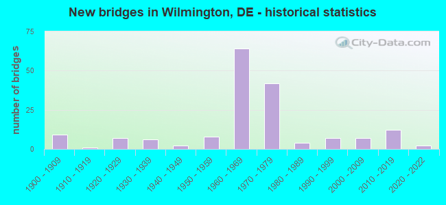
- New bridges - historical statistics
- 91900-1909
- 11910-1919
- 71920-1929
- 61930-1939
- 21940-1949
- 81950-1959
- 641960-1969
- 421970-1979
- 41980-1989
- 71990-1999
- 72000-2009
- 122010-2019
- 22020-2022
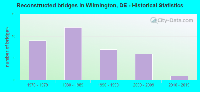
- Reconstructed bridges - Historical Statistics
- 91970-1979
- 121980-1989
- 71990-1999
- 62000-2009
- 12010-2019
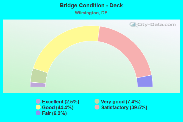
- Bridge Condition - Deck
- 2.5%Excellent
- 7.4%Very good
- 44.4%Good
- 39.5%Satisfactory
- 6.2%Fair
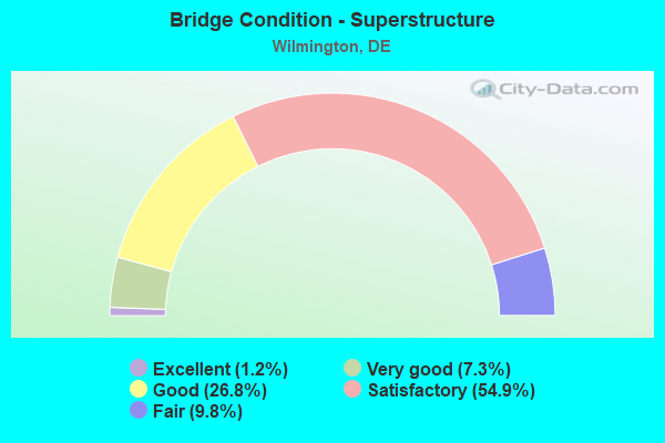
- Bridge Condition - Superstructure
- 1.2%Excellent
- 7.3%Very good
- 26.8%Good
- 54.9%Satisfactory
- 9.8%Fair
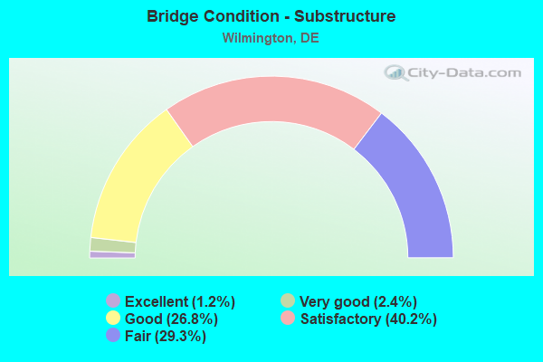
- Bridge Condition - Substructure
- 1.2%Excellent
- 2.4%Very good
- 26.8%Good
- 40.2%Satisfactory
- 29.3%Fair
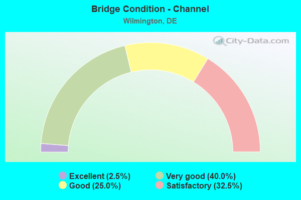
- Bridge Condition - Channel
- 2.5%Excellent
- 40.0%Very good
- 25.0%Good
- 32.5%Satisfactory
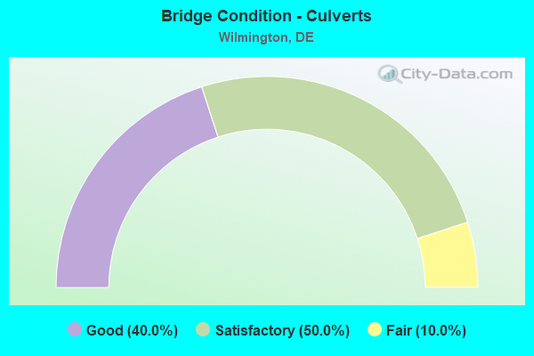
- Bridge Condition - Culverts
- 40.0%Good
- 50.0%Satisfactory
- 10.0%Fair
Find on map >> Show street view
Structure Number: 1001 279, Location: N/W WILMINGTON (Lat: 39.769297, Lng: -75.576700), Route carried "on" structure: County highway 279, Year Built: 1928, Year Reconstructed: 1979, Status: Posted for load, Structure Length: 3.93m (12.89ft), Average Daily Traffic: 2,390 (year 2019), Truck Traffic: 3%, Average Future Daily Traffic: 2,970 (year 2042), Design Load: HS 20+Mod, Features Intersected: BRANDYWINE CREEK, Facility Carried by Structure: RISING SUN LANE
Minimum Vertical Clearance: 4.28m (14.04ft), Kilometerpoint: 0.720, Lanes on structure: 2, Owner: State Highway Agency, Approaching Roadway Width: 5.8m (19.0ft), Material/Design: Steel, Design/Construction: Truss - Thru, Number Of Spans In Main Unit: 1, Length of Maximum Span: 37.5m (123.0ft), Curb or Sidewalk Widths: Left: 0.0m, Right: 1.5m (4.9ft), Curb-To-Curb Width: 6.1m (20.0ft), Out-to-Out Width: 8.2m (26.9ft)
Condition: Deck: Good, Superstructure: Satisfactory, Substructure: Fair, Channel: Very good, Operating Rating: 25.6 metric tons, Method Used To Determine Operating Rating: Load and Resistance Factor Rating (LRFR) rating reported by rating factor(RF) method using HL-93 loadings, Inventory Rating: 19.8 metric tons, Method Used To Determine Inventory Rating: Load and Resistance Factor Rating (LRFR) rating reported by rating factor(RF) method using HL-93 loadings, Structural Evaluation: Somewhat better than minimum adequacy, Deck Geometry: High priority of replacement, Waterway Adequacy: Better than present minimum criteria, Approach Roadway Alignment: Equal to present minimum criteria, Bridge Posting: Required (Relationship of Operating Rating to Maximum Legal Load: 20.0 - 29.9% below), Length Of Structure Improvement: 3.93m (12.89ft), Designated Inspection Frequency: Every 24 months, Critical Feature Inspection Frequency: Every 24 months, Inspection Date: April 2020, Critical Feature Inspection Date: April 2020, Bridge Improvement Cost: $348,000, Roadway Improvement Cost: $35,000, Total Project Cost: $522,000, Deck Structure Type: Concrete Cast-file-Place, Wearing Surface/Protective System: Wearing Surface: Latex Concrete
Find on map >> Show street view
Structure Number: 1001A279, Location: N/W WILMINGTON (Lat: 39.768989, Lng: -75.576914), Route carried "on" structure: County highway 279, Year Built: 1900, Year Reconstructed: 1995, Status: Open, Structure Length: 0.76m (2.49ft), Average Daily Traffic: 2,390 (year 2019), Truck Traffic: 8%, Average Future Daily Traffic: 2,970 (year 2042), Design Load: HS 20, Features Intersected: BRANDYWINE CREEK, Facility Carried by Structure: RISING SUN LANE
Minimum Vertical Clearance: 30.48m (100.00ft), Kilometerpoint: 0.719, Lanes on structure: 2, Owner: State Highway Agency, Approaching Roadway Width: 5.8m (19.0ft), Material/Design: Masonry, Design/Construction: Culvert, Number Of Spans In Main Unit: 1, Length of Maximum Span: 7.6m (24.9ft), Curb-To-Curb Width: 7.3m (24.0ft), Out-to-Out Width: 8.5m (27.9ft)
Condition: Channel: Satisfactory, Culverts: Satisfactory, Operating Rating: 54.4 metric tons, Method Used To Determine Operating Rating: Field evaluation and documented engineering judgment, Inventory Rating: 32.7 metric tons, Method Used To Determine Inventory Rating: Field evaluation and documented engineering judgment, Structural Evaluation: Equal to present minimum criteria, Deck Geometry: High priority of replacement, Waterway Adequacy: Better than present minimum criteria, Approach Roadway Alignment: Equal to present desirable criteria, Length Of Structure Improvement: 0.76m (2.49ft), Designated Inspection Frequency: Every 24 months, Inspection Date: June 2020, Bridge Improvement Cost: $78,000, Roadway Improvement Cost: $8,000, Total Project Cost: $120,000
Find on map >> Show street view
Structure Number: 1001B009, Location: WEST WILMINGTON (Lat: 39.767694, Lng: -75.585625), Route carried "on" structure: State highway 52, Year Built: 1919, Year Reconstructed: 2006, Status: Open, Structure Length: 0.63m (2.07ft), Average Daily Traffic: 16,745 (year 2018), Truck Traffic: 6%, Average Future Daily Traffic: 21,010 (year 2042), Design Load: HS 20, Features Intersected: WATERWAY & ABANDON R.R.
Minimum Vertical Clearance: 30.48m (100.00ft), Kilometerpoint: 8.240, Lanes on structure: 4, Base Highway Network: Yes, Owner: State Highway Agency, Approaching Roadway Width: 17.7m (58.1ft), Skew: 1 degrees, Material/Design: Aluminum, Iron, Design/Construction: Culvert, Number Of Spans In Main Unit: 1, Length of Maximum Span: 6.3m (20.7ft), Curb or Sidewalk Widths: Left: 1.7m (5.6ft), Right: 1.7m (5.6ft), Curb-To-Curb Width: 17.7m (58.1ft), Out-to-Out Width: 23.9m (78.4ft)
Condition: Channel: Good, Culverts: Good, Operating Rating: 64.7 metric tons, Method Used To Determine Operating Rating: Load Factor (LF), Inventory Rating: 38.8 metric tons, Method Used To Determine Inventory Rating: Load Factor (LF), Structural Evaluation: Better than present minimum criteria, Deck Geometry: Somewhat better than minimum adequacy, Waterway Adequacy: Equal to present desirable criteria, Approach Roadway Alignment: Equal to present desirable criteria, Length Of Structure Improvement: 0.85m (2.79ft), Designated Inspection Frequency: Every 24 months, Inspection Date: March 2020, Bridge Improvement Cost: $202,000, Roadway Improvement Cost: $20,000, Total Project Cost: $303,000
Find on map >> Show street view
Structure Number: 1011N267, Location: N/W OF BLUEBALL (Lat: 39.784292, Lng: -75.558369), Route carried "on" structure: State highway 141, Year Built: 1997, Status: Open, Structure Length: 1.77m (5.81ft), Average Daily Traffic: 13,033 (year 2019), Truck Traffic: 9%, Average Future Daily Traffic: 16,352 (year 2043), Design Load: HS 25 or greater, Features Intersected: ROCKLAND ROAD
Minimum Vertical Clearance: 30.48m (100.00ft), Kilometerpoint: 3.380, Lanes on structure: 2, Lanes under structure: 2, Base Highway Network: Yes, Owner: State Highway Agency, Approaching Roadway Width: 11.9m (39.0ft), Skew: 1 degrees, Material/Design: Concrete, Design/Construction: Frame, Number Of Spans In Main Unit: 1, Length of Maximum Span: 16.5m (54.1ft), Curb or Sidewalk Widths: Left: 0.0m, Right: 2.4m (7.9ft), Curb-To-Curb Width: 11.6m (38.1ft), Out-to-Out Width: 15.5m (50.9ft)
Condition: Deck: Satisfactory, Superstructure: Satisfactory, Substructure: Satisfactory, Inventory Rating: 72.2 metric tons, Method Used To Determine Inventory Rating: Load Factor (LF), Structural Evaluation: Equal to present minimum criteria, Deck Geometry: Better than present minimum criteria, Underclear: Somewhat better than minimum adequacy, Approach Roadway Alignment: Equal to present desirable criteria, Designated Inspection Frequency: Every 24 months, Inspection Date: March 2021, Deck Structure Type: Concrete Precast Panels, Wearing Surface/Protective System: Wearing Surface: Latex Concrete, Deck Protection: Epoxy Coated Reinforcing
Find on map >> Show street view
Structure Number: 1011S267, Location: N/W OF BLUEBALL (Lat: 39.784453, Lng: -75.558514), Route carried "on" structure: State highway 141, Year Built: 1997, Status: Open, Structure Length: 1.77m (5.81ft), Average Daily Traffic: 13,033 (year 2019), Truck Traffic: 9%, Average Future Daily Traffic: 16,352 (year 2043), Design Load: HS 25 or greater, Features Intersected: ROCKLAND ROAD
Minimum Vertical Clearance: 30.48m (100.00ft), Kilometerpoint: 5.568, Lanes on structure: 2, Lanes under structure: 2, Base Highway Network: Yes, Owner: State Highway Agency, Approaching Roadway Width: 11.0m (36.1ft), Skew: 1 degrees, Material/Design: Concrete, Design/Construction: Frame, Number Of Spans In Main Unit: 1, Length of Maximum Span: 16.5m (54.1ft), Curb-To-Curb Width: 11.6m (38.1ft), Out-to-Out Width: 12.8m (42.0ft)
Condition: Deck: Satisfactory, Superstructure: Satisfactory, Substructure: Good, Inventory Rating: 72.2 metric tons, Method Used To Determine Inventory Rating: Load Factor (LF), Structural Evaluation: Equal to present minimum criteria, Deck Geometry: Better than present minimum criteria, Underclear: Somewhat better than minimum adequacy, Approach Roadway Alignment: Equal to present desirable criteria, Designated Inspection Frequency: Every 24 months, Inspection Date: March 2021, Deck Structure Type: Concrete Precast Panels, Wearing Surface/Protective System: Wearing Surface: Latex Concrete, Deck Protection: Epoxy Coated Reinforcing
Find on map >> Show street view
Structure Number: 1020 232, Location: NORTH OF WILMINGTON (Lat: 39.786147, Lng: -75.561742), Route carried "on" structure: County highway 232, Year Built: 1932, Year Reconstructed: 1993, Status: Open, Structure Length: 0.84m (2.76ft), Average Daily Traffic: 4,269 (year 2019), Truck Traffic: 7%, Average Future Daily Traffic: 5,306 (year 2042), Design Load: HS 25 or greater, Features Intersected: HUSBANDS RUN, Facility Carried by Structure: ROCKLAND RD
Minimum Vertical Clearance: 30.48m (100.00ft), Kilometerpoint: 1.750, Lanes on structure: 2, Owner: State Highway Agency, Approaching Roadway Width: 6.1m (20.0ft), Material/Design: Concrete, Design/Construction: Slab, Number Of Spans In Main Unit: 1, Length of Maximum Span: 7.7m (25.3ft), Curb-To-Curb Width: 7.3m (24.0ft), Out-to-Out Width: 8.3m (27.2ft)
Condition: Deck: Good, Superstructure: Good, Substructure: Satisfactory, Channel: Good, Operating Rating: 52.5 metric tons, Method Used To Determine Operating Rating: Load and Resistance Factor Rating (LRFR) rating reported by rating factor(RF) method using HL-93 loadings, Inventory Rating: 40.5 metric tons, Method Used To Determine Inventory Rating: Load and Resistance Factor Rating (LRFR) rating reported by rating factor(RF) method using HL-93 loadings, Structural Evaluation: Equal to present minimum criteria, Deck Geometry: High priority of replacement, Waterway Adequacy: Equal to present minimum criteria, Approach Roadway Alignment: Equal to present desirable criteria, Length Of Structure Improvement: 0.76m (2.49ft), Designated Inspection Frequency: Every 24 months, Inspection Date: April 2020, Bridge Improvement Cost: $71,000, Roadway Improvement Cost: $7,000, Total Project Cost: $107,000, Deck Structure Type: Concrete Cast-file-Place, Wearing Surface/Protective System: Wearing Surface: Bituminous, Deck Protection: Epoxy Coated Reinforcing
Find on map >> Show street view
Structure Number: 1033 203, Location: FAIRFAX (Lat: 39.795153, Lng: -75.527286), Route carried "on" structure: State highway 261, Year Built: 1959, Year Reconstructed: 1992, Status: Open, Structure Length: 1.62m (5.31ft), Average Daily Traffic: 15,465 (year 2019), Truck Traffic: 9%, Average Future Daily Traffic: 19,221 (year 2042), Design Load: HS 20+Mod, Features Intersected: SHELLPOT CREEK
Minimum Vertical Clearance: 30.48m (100.00ft), Kilometerpoint: 2.480, Lanes on structure: 4, Owner: State Highway Agency, Approaching Roadway Width: 16.8m (55.1ft), Skew: 20 degrees, Material/Design: Prestressed concrete, Design/Construction: Box Beam or Girders - Multiple, Number Of Spans In Main Unit: 1, Length of Maximum Span: 15.7m (51.5ft), Curb or Sidewalk Widths: Left: 1.5m (4.9ft), Right: 1.5m (4.9ft), Curb-To-Curb Width: 15.1m (49.5ft), Out-to-Out Width: 19.4m (63.6ft)
Condition: Deck: Good, Superstructure: Satisfactory, Substructure: Satisfactory, Channel: Satisfactory, Operating Rating: 71.9 metric tons, Method Used To Determine Operating Rating: Load and Resistance Factor Rating (LRFR) rating reported by rating factor(RF) method using HL-93 loadings, Inventory Rating: 57.3 metric tons, Method Used To Determine Inventory Rating: Load and Resistance Factor Rating (LRFR) rating reported by rating factor(RF) method using HL-93 loadings, Structural Evaluation: Equal to present minimum criteria, Deck Geometry: High priority of corrective action, Waterway Adequacy: Equal to present minimum criteria, Approach Roadway Alignment: Equal to present desirable criteria, Length Of Structure Improvement: 3.05m (10.01ft), Designated Inspection Frequency: Every 24 months, Inspection Date: May 2020, Bridge Improvement Cost: $500,000, Roadway Improvement Cost: $100,000, Total Project Cost: $600,000, Deck Structure Type: Concrete Precast Panels, Wearing Surface/Protective System: Wearing Surface: Bituminous
Find on map >> Show street view
Structure Number: 1035 203, Location: NORTH OF WILMINGTON (Lat: 39.783444, Lng: -75.538806), Route carried "on" structure: State highway 203, Year Built: 1958, Status: Open, Structure Length: 0.73m (2.40ft), Average Daily Traffic: 13,850 (year 2019), Truck Traffic: 9%, Average Future Daily Traffic: 17,214 (year 2042), Design Load: HS 20, Features Intersected: MATSON RUN, Facility Carried by Structure: FOULK RD / SR261
Minimum Vertical Clearance: 30.48m (100.00ft), Kilometerpoint: 0.820, Lanes on structure: 4, Owner: State Highway Agency, Approaching Roadway Width: 16.0m (52.5ft), Skew: 23 degrees, Material/Design: Concrete, Design/Construction: Culvert, Number Of Spans In Main Unit: 2, Length of Maximum Span: 3.5m (11.5ft), Curb or Sidewalk Widths: Left: 2.0m (6.6ft), Right: 1.2m (3.9ft), Curb-To-Curb Width: 15.1m (49.5ft), Out-to-Out Width: 22.2m (72.8ft)
Condition: Channel: Satisfactory, Culverts: Satisfactory, Operating Rating: 43.7 metric tons, Method Used To Determine Operating Rating: Load and Resistance Factor Rating (LRFR) rating reported by rating factor(RF) method using HL-93 loadings, Inventory Rating: 30.1 metric tons, Method Used To Determine Inventory Rating: Load and Resistance Factor Rating (LRFR) rating reported by rating factor(RF) method using HL-93 loadings, Structural Evaluation: Equal to present minimum criteria, Deck Geometry: High priority of corrective action, Waterway Adequacy: Equal to present minimum criteria, Approach Roadway Alignment: Equal to present desirable criteria, Length Of Structure Improvement: 3.05m (10.01ft), Designated Inspection Frequency: Every 24 months, Inspection Date: May 2020, Bridge Improvement Cost: $500,000, Roadway Improvement Cost: $100,000, Total Project Cost: $600,000, Deck Structure Type: Concrete Cast-file-Place
Find on map >> Show street view
Structure Number: 1043 215, Location: E. OF BLUE BALL AREA (Lat: 39.780339, Lng: -75.526739), Route carried "on" structure: County highway 215, Year Built: 1999, Status: Open, Structure Length: 0.62m (2.03ft), Average Daily Traffic: 4,730 (year 2019), Truck Traffic: 8%, Average Future Daily Traffic: 5,934 (year 2043), Design Load: HS 25 or greater, Features Intersected: TURKEY RUN, Facility Carried by Structure: WELDIN RD
Minimum Vertical Clearance: 30.48m (100.00ft), Kilometerpoint: 1.432, Lanes on structure: 2, Owner: State Highway Agency, Approaching Roadway Width: 6.6m (21.7ft), Skew: 1 degrees, Material/Design: Concrete, Design/Construction: Culvert, Number Of Spans In Main Unit: 1, Length of Maximum Span: 6.2m (20.3ft), Curb-To-Curb Width: 9.6m (31.5ft), Out-to-Out Width: 10.6m (34.8ft)
Condition: Channel: Good, Culverts: Good, Operating Rating: 31.4 metric tons, Method Used To Determine Operating Rating: Load and Resistance Factor Rating (LRFR) rating reported by rating factor(RF) method using HL-93 loadings, Inventory Rating: 24.3 metric tons, Method Used To Determine Inventory Rating: Load and Resistance Factor Rating (LRFR) rating reported by rating factor(RF) method using HL-93 loadings, Structural Evaluation: Equal to present minimum criteria, Deck Geometry: Meets minimum limits, Waterway Adequacy: Equal to present minimum criteria, Approach Roadway Alignment: Equal to present desirable criteria, Designated Inspection Frequency: Every 24 months, Inspection Date: March 2021, Deck Structure Type: Concrete Cast-file-Place, Wearing Surface/Protective System: Wearing Surface: Bituminous, Deck Protection: Epoxy Coated Reinforcing
Find on map >> Show street view
Structure Number: 1043B043, Location: N.E. OF WILMINGTON (Lat: 39.770389, Lng: -75.517942), Route carried "on" structure: County highway 43, Year Built: 1963, Status: Open, Structure Length: 1.57m (5.15ft), Average Daily Traffic: 6,677 (year 2018), Truck Traffic: 6%, Average Future Daily Traffic: 8,377 (year 2042), Design Load: HS 20, Features Intersected: SHELLPOT CREEK, Facility Carried by Structure: WASHINGTON ST EXT
Minimum Vertical Clearance: 30.48m (100.00ft), Kilometerpoint: 4.940, Lanes on structure: 5, Owner: State Highway Agency, Approaching Roadway Width: 28.0m (91.9ft), Skew: 25 degrees, Material/Design: Concrete continuous, Design/Construction: Slab, Number Of Spans In Main Unit: 2, Length of Maximum Span: 7.9m (25.9ft), Curb or Sidewalk Widths: Left: 1.9m (6.2ft), Right: 1.9m (6.2ft), Curb-To-Curb Width: 25.7m (84.3ft), Out-to-Out Width: 33.3m (109.3ft)
Condition: Deck: Satisfactory, Superstructure: Satisfactory, Substructure: Satisfactory, Channel: Satisfactory, Operating Rating: 40.2 metric tons, Method Used To Determine Operating Rating: Load and Resistance Factor Rating (LRFR) rating reported by rating factor(RF) method using HL-93 loadings, Inventory Rating: 30.8 metric tons, Method Used To Determine Inventory Rating: Load and Resistance Factor Rating (LRFR) rating reported by rating factor(RF) method using HL-93 loadings, Structural Evaluation: Equal to present minimum criteria, Deck Geometry: Superior to present desirable criteria, Waterway Adequacy: Equal to present desirable criteria, Approach Roadway Alignment: Equal to present desirable criteria, Designated Inspection Frequency: Every 24 months, Inspection Date: March 2020, Deck Structure Type: Concrete Cast-file-Place, Wearing Surface/Protective System: Wearing Surface: Bituminous
Find on map >> Show street view
Structure Number: 1044 214, Location: N/E OF WILMINGTON (Lat: 39.772089, Lng: -75.517308), Route carried "on" structure: County highway 214, Year Built: 1991, Status: Open, Structure Length: 1.96m (6.43ft), Average Daily Traffic: 9,896 (year 2019), Truck Traffic: 8%, Average Future Daily Traffic: 12,416 (year 2043), Design Load: HS 20, Features Intersected: SHELLPOT CREEK, Facility Carried by Structure: SHIPLEY RD.
Minimum Vertical Clearance: 30.48m (100.00ft), Kilometerpoint: 0.982, Lanes on structure: 2, Owner: State Highway Agency, Approaching Roadway Width: 7.3m (24.0ft), Material/Design: Steel, Design/Construction: Culvert, Number Of Spans In Main Unit: 3, Length of Maximum Span: 5.9m (19.4ft), Curb-To-Curb Width: 12.2m (40.0ft), Out-to-Out Width: 13.5m (44.3ft)
Condition: Channel: Good, Culverts: Satisfactory, Operating Rating: 54.4 metric tons, Method Used To Determine Operating Rating: Field evaluation and documented engineering judgment, Inventory Rating: 32.7 metric tons, Method Used To Determine Inventory Rating: Field evaluation and documented engineering judgment, Structural Evaluation: Equal to present minimum criteria, Deck Geometry: Somewhat better than minimum adequacy, Waterway Adequacy: Equal to present minimum criteria, Approach Roadway Alignment: Equal to present desirable criteria, Designated Inspection Frequency: Every 24 months, Inspection Date: Febuary 2021
Find on map >> Show street view
Structure Number: 1048 21, Location: NORTH OF WILMINGTON (Lat: 39.792289, Lng: -75.521331), Route carried "on" structure: County highway 210, Year Built: 1954, Status: Open, Structure Length: 1.06m (3.48ft), Average Daily Traffic: 6,840 (year 2018), Truck Traffic: 9%, Average Future Daily Traffic: 8,582 (year 2042), Design Load: HS 20, Features Intersected: SHELLPOT CREEK, Facility Carried by Structure: WILSON ROAD
Minimum Vertical Clearance: 30.48m (100.00ft), Kilometerpoint: 2.221, Lanes on structure: 2, Owner: State Highway Agency, Approaching Roadway Width: 12.2m (40.0ft), Skew: 2 degrees, Material/Design: Concrete, Design/Construction: Culvert, Number Of Spans In Main Unit: 1, Length of Maximum Span: 10.6m (34.8ft), Curb or Sidewalk Widths: Left: 1.5m (4.9ft), Right: 1.5m (4.9ft), Curb-To-Curb Width: 12.2m (40.0ft), Out-to-Out Width: 16.0m (52.5ft)
Condition: Channel: Satisfactory, Culverts: Satisfactory, Operating Rating: 33.4 metric tons, Method Used To Determine Operating Rating: Load and Resistance Factor Rating (LRFR) rating reported by rating factor(RF) method using HL-93 loadings, Inventory Rating: 25.9 metric tons, Method Used To Determine Inventory Rating: Load and Resistance Factor Rating (LRFR) rating reported by rating factor(RF) method using HL-93 loadings, Structural Evaluation: Equal to present minimum criteria, Deck Geometry: Somewhat better than minimum adequacy, Waterway Adequacy: Superior to present desirable criteria, Approach Roadway Alignment: Equal to present desirable criteria, Designated Inspection Frequency: Every 24 months, Inspection Date: March 2020, Deck Structure Type: Concrete Cast-file-Place, Wearing Surface/Protective System: Wearing Surface: Bituminous
Find on map >> Show street view
Structure Number: 1058 217, Location: NORTH WILMINGTON (Lat: 39.771922, Lng: -75.529411), Route carried "on" structure: County highway 217, Year Built: 1980, Status: Open, Structure Length: 0.67m (2.20ft), Average Daily Traffic: 2,822 (year 2019), Truck Traffic: 8%, Average Future Daily Traffic: 3,507 (year 2042), Design Load: HS 20, Features Intersected: MATSON RUN, Facility Carried by Structure: MILLER RD.
Minimum Vertical Clearance: 30.48m (100.00ft), Kilometerpoint: 2.250, Lanes on structure: 2, Owner: State Highway Agency, Approaching Roadway Width: 8.2m (26.9ft), Material/Design: Concrete, Design/Construction: Culvert, Number Of Spans In Main Unit: 1, Length of Maximum Span: 6.7m (22.0ft), Curb-To-Curb Width: 11.3m (37.1ft), Out-to-Out Width: 11.9m (39.0ft)
Condition: Channel: Satisfactory, Culverts: Fair, Operating Rating: 69.0 metric tons, Method Used To Determine Operating Rating: Load and Resistance Factor Rating (LRFR) rating reported by rating factor(RF) method using HL-93 loadings, Inventory Rating: 53.5 metric tons, Method Used To Determine Inventory Rating: Load and Resistance Factor Rating (LRFR) rating reported by rating factor(RF) method using HL-93 loadings, Structural Evaluation: Somewhat better than minimum adequacy, Deck Geometry: Somewhat better than minimum adequacy, Waterway Adequacy: Equal to present minimum criteria, Approach Roadway Alignment: Equal to present desirable criteria, Designated Inspection Frequency: Every 24 months, Inspection Date: June 2020, Deck Structure Type: Concrete Cast-file-Place
Find on map >> Show street view
Structure Number: 1059, Location: S/E OF TALLEYVILLE (Lat: 39.799983, Lng: -75.532033), Route carried "on" structure: City street , Year Built: 1976, Status: Open, Structure Length: 1.16m (3.81ft), Average Daily Traffic: 99 (year 2019), Truck Traffic: 11%, Average Future Daily Traffic: 123 (year 2042), Design Load: HS 20, Features Intersected: SHELLPOT CREEK, Facility Carried by Structure: COACHMANS RD
Minimum Vertical Clearance: 30.48m (100.00ft), Kilometerpoint: 0.160, Lanes on structure: 2, Owner: State Highway Agency, Approaching Roadway Width: 9.8m (32.2ft), Skew: 2 degrees, Material/Design: Concrete, Design/Construction: Culvert, Number Of Spans In Main Unit: 3, Length of Maximum Span: 3.7m (12.1ft)
Condition: Channel: Good, Culverts: Good, Operating Rating: 39.9 metric tons, Method Used To Determine Operating Rating: Load and Resistance Factor Rating (LRFR) rating reported by rating factor(RF) method using HL-93 loadings, Inventory Rating: 30.8 metric tons, Method Used To Determine Inventory Rating: Load and Resistance Factor Rating (LRFR) rating reported by rating factor(RF) method using HL-93 loadings, Structural Evaluation: Better than present minimum criteria, Waterway Adequacy: Better than present minimum criteria, Approach Roadway Alignment: Equal to present desirable criteria, Designated Inspection Frequency: Every 24 months, Inspection Date: June 2020
Find on map >> Show street view
Structure Number: 1077 004, Location: NORTH WIMLINGTON (Lat: 39.777656, Lng: -75.544722), Route carried "on" structure: US 202, Year Built: 2006, Status: Open, Structure Length: 2.98m (9.78ft), Average Daily Traffic: 55,468 (year 2019), Truck Traffic: 7%, Average Future Daily Traffic: 68,942 (year 2042), Design Load: HS 20, Features Intersected: FAULK RD.
Minimum Vertical Clearance: 30.48m (100.00ft), Kilometerpoint: 2.832, Lanes on structure: 6, Lanes under structure: 3, Base Highway Network: Yes, Owner: State Highway Agency, Approaching Roadway Width: 27.6m (90.6ft), Material/Design: Prestressed concrete, Design/Construction: Box Beam or Girders - Single/Spread, Number Of Spans In Main Unit: 1, Length of Maximum Span: 26.7m (87.6ft), Curb-To-Curb Width: 41.7m (136.8ft), Out-to-Out Width: 42.9m (140.7ft)
Condition: Deck: Good, Superstructure: Good, Substructure: Good, Operating Rating: 91.0 metric tons, Method Used To Determine Operating Rating: Load and Resistance Factor Rating (LRFR) rating reported by rating factor(RF) method using HL-93 loadings, Inventory Rating: 71.0 metric tons, Method Used To Determine Inventory Rating: Load and Resistance Factor Rating (LRFR) rating reported by rating factor(RF) method using HL-93 loadings, Structural Evaluation: Better than present minimum criteria, Deck Geometry: Superior to present desirable criteria, Underclear: Somewhat better than minimum adequacy, Approach Roadway Alignment: Equal to present desirable criteria, Designated Inspection Frequency: Every 24 months, Inspection Date: May 2020, Deck Structure Type: Concrete Cast-file-Place, Wearing Surface/Protective System: Wearing Surface: Monolithic Concrete, Deck Protection: Epoxy Coated Reinforcing
Find on map >> Show street view
Structure Number: 1079 004, Location: NORTH WILMINGTON (Lat: 39.774969, Lng: -75.544231), Route carried "on" structure: US 202, Year Built: 2006, Status: Open, Structure Length: 1.95m (6.40ft), Average Daily Traffic: 47,422 (year 2018), Truck Traffic: 6%, Average Future Daily Traffic: 59,502 (year 2042), Design Load: HS 20, Features Intersected: EAST PARK DR.
Minimum Vertical Clearance: 30.48m (100.00ft), Kilometerpoint: 2.269, Lanes on structure: 9, Lanes under structure: 2, Base Highway Network: Yes, Owner: State Highway Agency, Approaching Roadway Width: 27.6m (90.6ft), Skew: 30 degrees, Material/Design: Prestressed concrete, Design/Construction: Box Beam or Girders - Multiple, Number Of Spans In Main Unit: 1, Length of Maximum Span: 18.1m (59.4ft), Curb-To-Curb Width: 47.1m (154.5ft), Out-to-Out Width: 50.8m (166.7ft)
Condition: Deck: Very good, Superstructure: Very good, Substructure: Good, Operating Rating: 40.2 metric tons, Method Used To Determine Operating Rating: Load and Resistance Factor Rating (LRFR) rating reported by rating factor(RF) method using HL-93 loadings, Inventory Rating: 31.1 metric tons, Method Used To Determine Inventory Rating: Load and Resistance Factor Rating (LRFR) rating reported by rating factor(RF) method using HL-93 loadings, Structural Evaluation: Better than present minimum criteria, Deck Geometry: High priority of corrective action, Underclear: Better than present minimum criteria, Approach Roadway Alignment: Equal to present desirable criteria, Designated Inspection Frequency: Every 24 months, Inspection Date: March 2020, Deck Structure Type: Concrete Cast-file-Place, Wearing Surface/Protective System: Wearing Surface: Monolithic Concrete, Deck Protection: Epoxy Coated Reinforcing
Find on map >> Show street view
Structure Number: 1543 213, Location: NORTH OF WILMINGTON (Lat: 39.773850, Lng: -75.515200), Route carried "on" structure: County highway 213, Year Built: 1934, Year Reconstructed: 2017, Status: Open, Structure Length: 1.28m (4.20ft), Average Daily Traffic: 1,717 (year 2020), Truck Traffic: 7%, Average Future Daily Traffic: 2,134 (year 2043), Design Load: HL 93, Features Intersected: SHELLPOT CREEK, Facility Carried by Structure: CARR RD
Minimum Vertical Clearance: 30.48m (100.00ft), Kilometerpoint: 0.402, Lanes on structure: 2, Owner: State Highway Agency, Approaching Roadway Width: 7.2m (23.6ft), Skew: 2 degrees, Material/Design: Steel, Design/Construction: Stringer/Multi-beam, Number Of Spans In Main Unit: 1, Length of Maximum Span: 11.0m (36.1ft), Curb-To-Curb Width: 10.3m (33.8ft), Out-to-Out Width: 11.6m (38.1ft)
Condition: Deck: Good, Superstructure: Good, Substructure: Good, Channel: Good, Operating Rating: 92.7 metric tons, Method Used To Determine Operating Rating: Load and Resistance Factor Rating (LRFR) rating reported by rating factor(RF) method using HL-93 loadings, Inventory Rating: 76.5 metric tons, Method Used To Determine Inventory Rating: Load and Resistance Factor Rating (LRFR) rating reported by rating factor(RF) method using HL-93 loadings, Structural Evaluation: Better than present minimum criteria, Deck Geometry: Somewhat better than minimum adequacy, Waterway Adequacy: Better than present minimum criteria, Approach Roadway Alignment: Equal to present desirable criteria, Length Of Structure Improvement: 1.38m (4.53ft), Designated Inspection Frequency: Every 24 months, Inspection Date: October 2021, Bridge Improvement Cost: $400,000, Roadway Improvement Cost: $60,000, Total Project Cost: $460,000, Deck Structure Type: Concrete Cast-file-Place, Wearing Surface/Protective System: Deck Protection: Epoxy Coated Reinforcing
Find on map >> Show street view
Structure Number: 1567A501, Location: CHERRY ISLAND (Lat: 39.739131, Lng: -75.510783), Route carried "on" structure: City street 501, Year Built: 2018, Status: Open, Structure Length: 4.42m (14.50ft), Average Daily Traffic: 747 (year 2019), Truck Traffic: 8%, Average Future Daily Traffic: 923 (year 2037), Design Load: HL 93, Features Intersected: SHELLPOT CREEK, Facility Carried by Structure: HAY RD.
Minimum Vertical Clearance: 30.48m (100.00ft), Kilometerpoint: 0.016, Lanes on structure: 2, Owner: City or Municipal Highway Agency, Approaching Roadway Width: 7.0m (23.0ft), Material/Design: Prestressed concrete, Design/Construction: Box Beam or Girders - Multiple, Number Of Spans In Main Unit: 2, Length of Maximum Span: 21.3m (69.9ft), Curb-To-Curb Width: 10.4m (34.1ft), Out-to-Out Width: 11.8m (38.7ft)
Condition: Deck: Very good, Superstructure: Very good, Substructure: Good, Channel: Excellent, Operating Rating: 63.2 metric tons, Method Used To Determine Operating Rating: Load and Resistance Factor Rating (LRFR) rating reported by rating factor(RF) method using HL-93 loadings, Inventory Rating: 35.3 metric tons, Method Used To Determine Inventory Rating: Load and Resistance Factor Rating (LRFR) rating reported by rating factor(RF) method using HL-93 loadings, Structural Evaluation: Better than present minimum criteria, Deck Geometry: Equal to present minimum criteria, Waterway Adequacy: Equal to present minimum criteria, Approach Roadway Alignment: Somewhat better than minimum adequacy, Length Of Structure Improvement: 3.96m (12.99ft), Designated Inspection Frequency: Every 24 months, Inspection Date: November 2020, Bridge Improvement Cost: $185,000, Roadway Improvement Cost: $18,000, Total Project Cost: $277,000, Deck Structure Type: Concrete Cast-file-Place, Wearing Surface/Protective System: Wearing Surface: Monolithic Concrete, Deck Protection: Epoxy Coated Reinforcing
Find on map >> Show street view
Structure Number: 1570 004, Location: NORTH OF WILMINGTON (Lat: 39.766975, Lng: -75.542989), Route carried "on" structure: US 202, Year Built: 1967, Year Reconstructed: 2014, Status: Open, Structure Length: 7.26m (23.82ft), Average Daily Traffic: 46,561 (year 2019), Truck Traffic: 6%, Average Future Daily Traffic: 57,871 (year 2042), Design Load: HS 20, Features Intersected: I 95
Minimum Vertical Clearance: 30.48m (100.00ft), Kilometerpoint: 1.625, Lanes on structure: 6, Lanes under structure: 6, Base Highway Network: Yes, Owner: State Highway Agency, Approaching Roadway Width: 27.4m (89.9ft), Skew: 20 degrees, Material/Design: Steel continuous, Design/Construction: Stringer/Multi-beam, Number Of Spans In Main Unit: 2, Number Of Approach Spans: 2, Length of Maximum Span: 25.9m (85.0ft), Curb-To-Curb Width: 27.4m (89.9ft), Out-to-Out Width: 28.0m (91.9ft)
Condition: Deck: Good, Superstructure: Satisfactory, Substructure: Satisfactory, Operating Rating: 55.1 metric tons, Method Used To Determine Operating Rating: Load and Resistance Factor Rating (LRFR) rating reported by rating factor(RF) method using HL-93 loadings, Inventory Rating: 42.4 metric tons, Method Used To Determine Inventory Rating: Load and Resistance Factor Rating (LRFR) rating reported by rating factor(RF) method using HL-93 loadings, Structural Evaluation: Equal to present minimum criteria, Deck Geometry: Better than present minimum criteria, Underclear: Meets minimum limits, Approach Roadway Alignment: Equal to present desirable criteria, Length Of Structure Improvement: 7.26m (23.82ft), Designated Inspection Frequency: Every 24 months, Inspection Date: May 2020, Bridge Improvement Cost: $220,000, Roadway Improvement Cost: $22,000, Total Project Cost: $330,000, Deck Structure Type: Concrete Cast-file-Place, Wearing Surface/Protective System: Wearing Surface: Monolithic Concrete, Deck Protection: Epoxy Coated Reinforcing
Find on map >> Show street view
Structure Number: 1575 024, Location: WILMINGTON (Lat: 39.750389, Lng: -75.543836), Route carried "on" structure: Business US 13B, Year Built: 1928, Year Reconstructed: 2002, Status: Open, Structure Length: 6.43m (21.10ft), Average Daily Traffic: 11,011 (year 2019), Truck Traffic: 9%, Average Future Daily Traffic: 13,685 (year 2042), Design Load: HS 20, Features Intersected: BRANDYWINE CREEK, Facility Carried by Structure: NORTH MARKET ST
Minimum Vertical Clearance: 30.48m (100.00ft), Kilometerpoint: 1.625, Lanes on structure: 5, Base Highway Network: Yes, Owner: State Highway Agency, Approaching Roadway Width: 11.9m (39.0ft), Navigation Control: Yes ( Vertical Clearance: 4.0m (13.1ft), Horizontal Clearance: 45.0m (147.6ft)), Material/Design: Steel, Design/Construction: Stringer/Multi-beam, Number Of Spans In Main Unit: 1, Length of Maximum Span: 47.2m (154.9ft), Curb or Sidewalk Widths: Left: 3.0m (9.8ft), Right: 3.0m (9.8ft), Curb-To-Curb Width: 18.3m (60.0ft), Out-to-Out Width: 25.3m (83.0ft)
Condition: Deck: Good, Superstructure: Satisfactory, Substructure: Satisfactory, Channel: Very good, Operating Rating: 39.2 metric tons, Method Used To Determine Operating Rating: Load and Resistance Factor Rating (LRFR) rating reported by rating factor(RF) method using HL-93 loadings, Inventory Rating: 30.1 metric tons, Method Used To Determine Inventory Rating: Load and Resistance Factor Rating (LRFR) rating reported by rating factor(RF) method using HL-93 loadings, Structural Evaluation: Equal to present minimum criteria, Deck Geometry: High priority of replacement, Waterway Adequacy: Equal to present desirable criteria, Approach Roadway Alignment: Equal to present desirable criteria, Length Of Structure Improvement: 6.43m (21.10ft), Designated Inspection Frequency: Every 24 months, Inspection Date: April 2020, Bridge Improvement Cost: $70,000, Roadway Improvement Cost: $7,000, Total Project Cost: $105,000, Deck Structure Type: Concrete Cast-file-Place, Wearing Surface/Protective System: Wearing Surface: Monolithic Concrete, Deck Protection: Epoxy Coated Reinforcing
Find on map >> Show street view
Structure Number: 1576 043, Location: WILMINGTON (Lat: 39.752292, Lng: -75.548314), Route carried "on" structure: County highway 43, Year Built: 1922, Year Reconstructed: 2000, Status: Open, Structure Length: 19.20m (62.99ft), Average Daily Traffic: 11,308 (year 2019), Truck Traffic: 6%, Average Future Daily Traffic: 14,055 (year 2042), Features Intersected: BRANDYWINE CK, CONRAIL, Facility Carried by Structure: WASHINGTON ST.
Minimum Vertical Clearance: 30.48m (100.00ft), Kilometerpoint: 1.593, Lanes on structure: 4, Lanes under structure: 4, Owner: State Highway Agency, Approaching Roadway Width: 12.2m (40.0ft), Skew: 3 degrees, Material/Design: Concrete, Design/Construction: Arch - Deck, Number Of Spans In Main Unit: 5, Length of Maximum Span: 76.2m (250.0ft), Curb or Sidewalk Widths: Left: 4.3m (14.1ft), Right: 4.3m (14.1ft), Curb-To-Curb Width: 12.2m (40.0ft), Out-to-Out Width: 22.1m (72.5ft)
Condition: Deck: Good, Superstructure: Satisfactory, Substructure: Satisfactory, Channel: Good, Operating Rating: 47.2 metric tons, Method Used To Determine Operating Rating: Allowable Stress (AS), Inventory Rating: 28.1 metric tons, Method Used To Determine Inventory Rating: Allowable Stress (AS), Structural Evaluation: Equal to present minimum criteria, Deck Geometry: High priority of replacement, Underclear: Meets minimum limits, Waterway Adequacy: Superior to present desirable criteria, Approach Roadway Alignment: Equal to present desirable criteria, Length Of Structure Improvement: 21.95m (72.01ft), Designated Inspection Frequency: Every 24 months, Inspection Date: April 2020, Bridge Improvement Cost: $5,184,000, Roadway Improvement Cost: $518,000, Total Project Cost: $7,776,000, Deck Structure Type: Concrete Cast-file-Place, Wearing Surface/Protective System: Wearing Surface: Bituminous, Deck Protection: Epoxy Coated Reinforcing
Find on map >> Show street view
Structure Number: 1577 05, Location: WILMINGTON (Lat: 39.743339, Lng: -75.537453), Route carried "on" structure: US 13, Year Built: 1932, Year Reconstructed: 1994, Status: Open, Structure Length: 9.78m (32.09ft), Average Daily Traffic: 17,691 (year 2019), Truck Traffic: 9%, Average Future Daily Traffic: 21,988 (year 2042), Design Load: HS 20+Mod, Features Intersected: BRANDYWINE RIVER, Facility Carried by Structure: NORTHEAST BLVD
Minimum Vertical Clearance: 30.48m (100.00ft), Kilometerpoint: 1.336, Lanes on structure: 4, Owner: State Highway Agency, Approaching Roadway Width: 13.4m (44.0ft), Navigation Control: Yes ( Vertical Clearance: 4.0m (13.1ft), Horizontal Clearance: 12.0m (39.4ft)), Material/Design: Steel, Design/Construction: Girder and Floorbeam System, Number Of Spans In Main Unit: 1, Number Of Approach Spans: 6, Length of Maximum Span: 16.8m (55.1ft), Curb or Sidewalk Widths: Left: 2.6m (8.5ft), Right: 2.6m (8.5ft), Curb-To-Curb Width: 13.4m (44.0ft), Out-to-Out Width: 19.1m (62.7ft)
Condition: Deck: Good, Superstructure: Good, Substructure: Satisfactory, Channel: Satisfactory, Operating Rating: 38.9 metric tons, Method Used To Determine Operating Rating: Load and Resistance Factor Rating (LRFR) rating reported by rating factor(RF) method using HL-93 loadings, Inventory Rating: 31.8 metric tons, Method Used To Determine Inventory Rating: Load and Resistance Factor Rating (LRFR) rating reported by rating factor(RF) method using HL-93 loadings, Structural Evaluation: Equal to present minimum criteria, Deck Geometry: High priority of replacement, Waterway Adequacy: Equal to present desirable criteria, Approach Roadway Alignment: Equal to present desirable criteria, Length Of Structure Improvement: 9.78m (32.09ft), Designated Inspection Frequency: Every 24 months, Underwater Inspection Frequency: Every 24 months, Inspection Date: April 2020, Underwater Inspection Date: March 2020, Bridge Improvement Cost: $2,006,000, Roadway Improvement Cost: $201,000, Total Project Cost: $3,009,000, Deck Structure Type: Concrete Cast-file-Place, Wearing Surface/Protective System: Wearing Surface: Monolithic Concrete, Deck Protection: Epoxy Coated Reinforcing
Find on map >> Show street view
Structure Number: 1578 05, Location: WILMINGTON (Lat: 39.753047, Lng: -75.515933), Route carried "on" structure: US 13, Year Built: 1934, Year Reconstructed: 2000, Status: Open, Structure Length: 1.51m (4.95ft), Average Daily Traffic: 10,665 (year 2019), Truck Traffic: 9%, Average Future Daily Traffic: 13,255 (year 2042), Design Load: HS 20, Features Intersected: SHELLPOT CREEK, Facility Carried by Structure: GOV PRINTZ BLVD
Minimum Vertical Clearance: 30.48m (100.00ft), Kilometerpoint: 3.560, Lanes on structure: 4, Owner: State Highway Agency, Approaching Roadway Width: 21.3m (69.9ft), Skew: 2 degrees, Material/Design: Prestressed concrete, Design/Construction: Box Beam or Girders - Multiple, Number Of Spans In Main Unit: 1, Length of Maximum Span: 14.0m (45.9ft), Curb or Sidewalk Widths: Left: 1.8m (5.9ft), Right: 1.8m (5.9ft), Curb-To-Curb Width: 23.2m (76.1ft), Out-to-Out Width: 27.6m (90.6ft)
Condition: Deck: Good, Superstructure: Good, Substructure: Good, Channel: Satisfactory, Operating Rating: 45.0 metric tons, Method Used To Determine Operating Rating: Load and Resistance Factor Rating (LRFR) rating reported by rating factor(RF) method using HL-93 loadings, Inventory Rating: 35.3 metric tons, Method Used To Determine Inventory Rating: Load and Resistance Factor Rating (LRFR) rating reported by rating factor(RF) method using HL-93 loadings, Structural Evaluation: Better than present minimum criteria, Deck Geometry: Superior to present desirable criteria, Waterway Adequacy: Equal to present minimum criteria, Approach Roadway Alignment: Equal to present desirable criteria, Designated Inspection Frequency: Every 24 months, Inspection Date: April 2020, Deck Structure Type: Concrete Cast-file-Place, Wearing Surface/Protective System: Wearing Surface: Monolithic Concrete, Deck Protection: Epoxy Coated Reinforcing
Find on map >> Show street view
Structure Number: 1585 049, Location: WILMINGTON (Lat: 39.760919, Lng: -75.557033), Route carried "on" structure: County highway 49, Year Built: 1900, Year Reconstructed: 1980, Status: Open, Structure Length: 25.17m (82.58ft), Average Daily Traffic: 8,479 (year 2020), Truck Traffic: 9%, Average Future Daily Traffic: 10,538 (year 2043), Design Load: HS 20, Features Intersected: BRANDYWINE CREEK, Facility Carried by Structure: AUGUSTINE CUTOFF
Minimum Vertical Clearance: 30.48m (100.00ft), Kilometerpoint: 1.368, Lanes on structure: 2, Lanes under structure: 4, Owner: State Highway Agency, Approaching Roadway Width: 12.2m (40.0ft), Material/Design: Steel continuous, Design/Construction: Truss - Deck, Number Of Spans In Main Unit: 6, Length of Maximum Span: 50.0m (164.0ft), Curb or Sidewalk Widths: Left: 2.1m (6.9ft), Right: 2.1m (6.9ft), Curb-To-Curb Width: 12.2m (40.0ft), Out-to-Out Width: 17.1m (56.1ft)
Condition: Deck: Good, Superstructure: Satisfactory, Substructure: Good, Channel: Very good, Operating Rating: 69.9 metric tons, Method Used To Determine Operating Rating: Load Factor (LF), Inventory Rating: 42.1 metric tons, Method Used To Determine Inventory Rating: Load Factor (LF), Structural Evaluation: Equal to present minimum criteria, Deck Geometry: Somewhat better than minimum adequacy, Underclear: High priority of corrective action, Waterway Adequacy: Equal to present desirable criteria, Approach Roadway Alignment: Equal to present desirable criteria, Length Of Structure Improvement: 25.17m (82.58ft), Designated Inspection Frequency: Every 24 months, Critical Feature Inspection Frequency: Every 24 months, Inspection Date: August 2021, Critical Feature Inspection Date: August 2021, Bridge Improvement Cost: $500,000, Roadway Improvement Cost: $50,000, Total Project Cost: $750,000, Deck Structure Type: Concrete Cast-file-Place, Wearing Surface/Protective System: Wearing Surface: Other, Deck Protection: Epoxy Coated Reinforcing
Find on map >> Show street view
Structure Number: 1587 267, Location: N/W WILMINGTON-GREENVILLE (Lat: 39.773222, Lng: -75.578272), Route carried "on" structure: State highway 141, Year Built: 1951, Year Reconstructed: 1980, Status: Open, Structure Length: 24.87m (81.59ft), Average Daily Traffic: 25,624 (year 2019), Truck Traffic: 7%, Average Future Daily Traffic: 31,687 (year 2038), Design Load: HS 20, Features Intersected: BRANDYWINE CREEK, RD 260
Minimum Vertical Clearance: 30.48m (100.00ft), Kilometerpoint: 1.062, Lanes on structure: 2, Lanes under structure: 4, Base Highway Network: Yes, Owner: State Highway Agency, Approaching Roadway Width: 12.2m (40.0ft), Material/Design: Steel continuous, Design/Construction: Girder and Floorbeam System, Number Of Spans In Main Unit: 3, Number Of Approach Spans: 9, Length of Maximum Span: 48.2m (158.1ft), Curb-To-Curb Width: 9.3m (30.5ft), Out-to-Out Width: 10.1m (33.1ft)
Condition: Deck: Good, Superstructure: Satisfactory, Substructure: Satisfactory, Channel: Very good, Operating Rating: 28.5 metric tons, Method Used To Determine Operating Rating: Load and Resistance Factor Rating (LRFR) rating reported by rating factor(RF) method using HL-93 loadings, Inventory Rating: 21.1 metric tons, Method Used To Determine Inventory Rating: Load and Resistance Factor Rating (LRFR) rating reported by rating factor(RF) method using HL-93 loadings, Structural Evaluation: Somewhat better than minimum adequacy, Deck Geometry: Meets minimum limits, Underclear: High priority of corrective action, Waterway Adequacy: Equal to present desirable criteria, Approach Roadway Alignment: Equal to present minimum criteria, Length Of Structure Improvement: 24.87m (81.59ft), Designated Inspection Frequency: Every 24 months, Critical Feature Inspection Frequency: Every 24 months, Inspection Date: August 2020, Critical Feature Inspection Date: August 2020, Bridge Improvement Cost: $2,693,000, Roadway Improvement Cost: $269,000, Total Project Cost: $4,039,000, Deck Structure Type: Concrete Cast-file-Place, Wearing Surface/Protective System: Wearing Surface: Monolithic Concrete, Deck Protection: Epoxy Coated Reinforcing
Find on map >> Show street view
Structure Number: 1609 237, Location: WILMINGTON (Lat: 39.749433, Lng: -75.580906), Route carried "on" structure: State highway 48, Year Built: 1900, Year Reconstructed: 1978, Status: Open, Structure Length: 2.59m (8.50ft), Average Daily Traffic: 25,087 (year 2018), Truck Traffic: 6%, Average Future Daily Traffic: 31,776 (year 2043), Design Load: HS 20, Features Intersected: CSX RAILROAD
Minimum Vertical Clearance: 30.48m (100.00ft), Kilometerpoint: 12.920, Lanes on structure: 3, Base Highway Network: Yes, Owner: State Highway Agency, Approaching Roadway Width: 11.6m (38.1ft), Skew: 2 degrees, Material/Design: Steel, Design/Construction: Stringer/Multi-beam, Number Of Spans In Main Unit: 1, Length of Maximum Span: 24.7m (81.0ft), Curb or Sidewalk Widths: Left: 1.6m (5.2ft), Right: 2.6m (8.5ft), Curb-To-Curb Width: 11.6m (38.1ft), Out-to-Out Width: 16.8m (55.1ft)
Condition: Deck: Satisfactory, Superstructure: Good, Substructure: Good, Operating Rating: 86.5 metric tons, Method Used To Determine Operating Rating: Load and Resistance Factor Rating (LRFR) rating reported by rating factor(RF) method using HL-93 loadings, Inventory Rating: 66.7 metric tons, Method Used To Determine Inventory Rating: Load and Resistance Factor Rating (LRFR) rating reported by rating factor(RF) method using HL-93 loadings, Structural Evaluation: Better than present minimum criteria, Deck Geometry: High priority of replacement, Underclear: High priority of corrective action, Approach Roadway Alignment: Equal to present desirable criteria, Length Of Structure Improvement: 2.59m (8.50ft), Designated Inspection Frequency: Every 24 months, Inspection Date: April 2020, Bridge Improvement Cost: $468,000, Roadway Improvement Cost: $47,000, Total Project Cost: $701,000, Deck Structure Type: Concrete Cast-file-Place, Wearing Surface/Protective System: Wearing Surface: Monolithic Concrete, Deck Protection: Epoxy Coated Reinforcing
Find on map >> Show street view
Structure Number: 1609A, Location: WILMINGTON (Lat: 39.751153, Lng: -75.577644), Route carried "on" structure: City street , Year Built: 1900, Year Reconstructed: 1979, Status: Open, Structure Length: 2.29m (7.51ft), Average Daily Traffic: 99 (year 2018), Truck Traffic: 13%, Average Future Daily Traffic: 124 (year 2042), Design Load: HS 20, Features Intersected: CSX RAILROAD, Facility Carried by Structure: FOURTH ST
Minimum Vertical Clearance: 30.48m (100.00ft), Kilometerpoint: 0.724, Lanes on structure: 2, Owner: State Highway Agency, Approaching Roadway Width: 17.4m (57.1ft), Skew: 2 degrees, Material/Design: Steel, Design/Construction: Stringer/Multi-beam, Number Of Spans In Main Unit: 1, Length of Maximum Span: 21.3m (69.9ft), Curb or Sidewalk Widths: Left: 1.5m (4.9ft), Right: 2.4m (7.9ft), Curb-To-Curb Width: 17.4m (57.1ft), Out-to-Out Width: 22.6m (74.1ft)
Condition: Deck: Very good, Superstructure: Good, Substructure: Satisfactory, Operating Rating: 26.6 metric tons, Method Used To Determine Operating Rating: Load and Resistance Factor Rating (LRFR) rating reported by rating factor(RF) method using HL-93 loadings, Inventory Rating: 20.4 metric tons, Method Used To Determine Inventory Rating: Load and Resistance Factor Rating (LRFR) rating reported by rating factor(RF) method using HL-93 loadings, Structural Evaluation: Somewhat better than minimum adequacy, Deck Geometry: Superior to present desirable criteria, Underclear: High priority of corrective action, Approach Roadway Alignment: Equal to present desirable criteria, Length Of Structure Improvement: 2.29m (7.51ft), Designated Inspection Frequency: Every 24 months, Inspection Date: April 2020, Bridge Improvement Cost: $550,000, Roadway Improvement Cost: $55,000, Total Project Cost: $825,000, Deck Structure Type: Concrete Cast-file-Place, Wearing Surface/Protective System: Wearing Surface: Monolithic Concrete, Deck Protection: Epoxy Coated Reinforcing
Find on map >> Show street view
Structure Number: 1609B, Location: WILMINGTON (Lat: 39.752214, Lng: -75.575561), Route carried "on" structure: City street , Year Built: 1950, Year Reconstructed: 2008, Status: Open, Structure Length: 2.16m (7.09ft), Average Daily Traffic: 99 (year 2018), Truck Traffic: 11%, Average Future Daily Traffic: 124 (year 2042), Design Load: HS 20+Mod, Features Intersected: CSX, Facility Carried by Structure: SIXTH ST
Minimum Vertical Clearance: 30.48m (100.00ft), Kilometerpoint: 0.724, Lanes on structure: 2, Owner: State Highway Agency, Approaching Roadway Width: 7.6m (24.9ft), Skew: 2 degrees, Material/Design: Steel, Design/Construction: Stringer/Multi-beam, Number Of Spans In Main Unit: 1, Length of Maximum Span: 21.3m (69.9ft), Curb or Sidewalk Widths: Left: 1.7m (5.6ft), Right: 1.8m (5.9ft), Curb-To-Curb Width: 7.6m (24.9ft), Out-to-Out Width: 12.2m (40.0ft)
Condition: Deck: Good, Superstructure: Good, Substructure: Satisfactory, Operating Rating: 74.5 metric tons, Method Used To Determine Operating Rating: Load and Resistance Factor Rating (LRFR) rating reported by rating factor(RF) method using HL-93 loadings, Inventory Rating: 57.3 metric tons, Method Used To Determine Inventory Rating: Load and Resistance Factor Rating (LRFR) rating reported by rating factor(RF) method using HL-93 loadings, Structural Evaluation: Equal to present minimum criteria, Deck Geometry: Equal to present minimum criteria, Underclear: Somewhat better than minimum adequacy, Approach Roadway Alignment: Equal to present desirable criteria, Designated Inspection Frequency: Every 24 months, Inspection Date: April 2020, Deck Structure Type: Concrete Cast-file-Place, Wearing Surface/Protective System: Wearing Surface: Monolithic Concrete, Deck Protection: Epoxy Coated Reinforcing
Find on map >> Show street view
Structure Number: 1609D, Location: N/W WILMINGTON (Lat: 39.754208, Lng: -75.571769), Route carried "on" structure: City street , Year Built: 2006, Status: Open, Structure Length: 2.61m (8.56ft), Average Daily Traffic: 99 (year 2018), Truck Traffic: 11%, Average Future Daily Traffic: 124 (year 2042), Design Load: HS 20+Mod, Features Intersected: CSX, Facility Carried by Structure: NINTH ST
Minimum Vertical Clearance: 30.48m (100.00ft), Kilometerpoint: 3.219, Lanes on structure: 2, Owner: State Highway Agency, Approaching Roadway Width: 7.6m (24.9ft), Skew: 2 degrees, Material/Design: Steel, Design/Construction: Stringer/Multi-beam, Number Of Spans In Main Unit: 1, Length of Maximum Span: 25.0m (82.0ft), Curb or Sidewalk Widths: Left: 1.8m (5.9ft), Right: 1.8m (5.9ft), Curb-To-Curb Width: 7.6m (24.9ft), Out-to-Out Width: 12.1m (39.7ft)
Condition: Deck: Good, Superstructure: Satisfactory, Substructure: Good, Operating Rating: 65.1 metric tons, Method Used To Determine Operating Rating: Load and Resistance Factor Rating (LRFR) rating reported by rating factor(RF) method using HL-93 loadings, Inventory Rating: 50.2 metric tons, Method Used To Determine Inventory Rating: Load and Resistance Factor Rating (LRFR) rating reported by rating factor(RF) method using HL-93 loadings, Structural Evaluation: Equal to present minimum criteria, Deck Geometry: Equal to present minimum criteria, Underclear: Somewhat better than minimum adequacy, Approach Roadway Alignment: Equal to present desirable criteria, Designated Inspection Frequency: Every 24 months, Inspection Date: April 2020, Deck Structure Type: Concrete Cast-file-Place, Wearing Surface/Protective System: Wearing Surface: Monolithic Concrete, Deck Protection: Epoxy Coated Reinforcing
Find on map >> Show street view
Structure Number: 1633 011, Location: WILMINGTON (Lat: 39.742203, Lng: -75.577281), Route carried "on" structure: State highway 2, Year Built: 1963, Status: Open, Structure Length: 1.83m (6.00ft), Average Daily Traffic: 20,547 (year 2019), Truck Traffic: 9%, Average Future Daily Traffic: 25,538 (year 2042), Design Load: HS 20, Features Intersected: CANBY PARK VIADUCT, Facility Carried by Structure: SOUTH LINCOLN ST
Minimum Vertical Clearance: 30.48m (100.00ft), Kilometerpoint: 22.230, Lanes on structure: 2, Base Highway Network: Yes, Owner: State Highway Agency, Approaching Roadway Width: 10.4m (34.1ft), Material/Design: Concrete, Design/Construction: Slab, Number Of Spans In Main Unit: 1, Length of Maximum Span: 15.2m (49.9ft), Curb or Sidewalk Widths: Left: 0.0m, Right: 1.8m (5.9ft), Curb-To-Curb Width: 10.4m (34.1ft), Out-to-Out Width: 13.6m (44.6ft)
Condition: Deck: Good, Superstructure: Satisfactory, Substructure: Satisfactory, Channel: Very good, Operating Rating: 31.1 metric tons, Method Used To Determine Operating Rating: Load and Resistance Factor Rating (LRFR) rating reported by rating factor(RF) method using HL-93 loadings, Inventory Rating: 24.0 metric tons, Method Used To Determine Inventory Rating: Load and Resistance Factor Rating (LRFR) rating reported by rating factor(RF) method using HL-93 loadings, Structural Evaluation: Somewhat better than minimum adequacy, Deck Geometry: Meets minimum limits, Waterway Adequacy: Equal to present desirable criteria, Approach Roadway Alignment: Equal to present desirable criteria, Designated Inspection Frequency: Every 24 months, Inspection Date: July 2020, Deck Structure Type: Concrete Cast-file-Place, Wearing Surface/Protective System: Wearing Surface: Monolithic Concrete
Find on map >> Show street view
Structure Number: 1667S033, Location: S. OF WILMINGTON (Lat: 39.716072, Lng: -75.558536), Route carried "on" structure: US 13, Year Built: 1992, Status: Open, Structure Length: 0.64m (2.10ft), Average Daily Traffic: 16,111 (year 2019), Truck Traffic: 6%, Average Future Daily Traffic: 20,024 (year 2042), Design Load: HS 20, Features Intersected: WATERWAY
Minimum Vertical Clearance: 30.48m (100.00ft), Kilometerpoint: 9.511, Lanes on structure: 2, Base Highway Network: Yes, Owner: State Highway Agency, Approaching Roadway Width: 15.2m (49.9ft), Material/Design: Concrete, Design/Construction: Culvert, Number Of Spans In Main Unit: 1, Length of Maximum Span: 6.4m (21.0ft), Curb-To-Curb Width: 16.5m (54.1ft), Out-to-Out Width: 17.3m (56.8ft)
Condition: Channel: Very good, Culverts: Satisfactory, Operating Rating: 43.1 metric tons, Method Used To Determine Operating Rating: Load and Resistance Factor Rating (LRFR) rating reported by rating factor(RF) method using HL-93 loadings, Inventory Rating: 33.0 metric tons, Method Used To Determine Inventory Rating: Load and Resistance Factor Rating (LRFR) rating reported by rating factor(RF) method using HL-93 loadings, Structural Evaluation: Equal to present minimum criteria, Deck Geometry: Superior to present desirable criteria, Waterway Adequacy: Equal to present desirable criteria, Approach Roadway Alignment: Equal to present desirable criteria, Designated Inspection Frequency: Every 24 months, Inspection Date: May 2020, Deck Structure Type: Concrete Cast-file-Place, Wearing Surface/Protective System: Wearing Surface: Bituminous, Deck Protection: Epoxy Coated Reinforcing
Find on map >> Show street view
Structure Number: 1683 029, Location: S. OF WILMIGTON (Lat: 39.731919, Lng: -75.553372), Route carried "on" structure: US 13, Year Built: 2010, Status: Open, Structure Length: 0.94m (3.08ft), Average Daily Traffic: 29,936 (year 2019), Truck Traffic: 6%, Average Future Daily Traffic: 35,944 (year 2038), Design Load: HS 20+Mod, Features Intersected: SHOPPING PLAZA DRAINAGE
Minimum Vertical Clearance: 30.48m (100.00ft), Kilometerpoint: 1.368, Lanes on structure: 4, Base Highway Network: Yes, Owner: State Highway Agency, Approaching Roadway Width: 16.0m (52.5ft), Material/Design: Concrete, Design/Construction: Culvert, Number Of Spans In Main Unit: 2, Length of Maximum Span: 4.4m (14.4ft), Curb or Sidewalk Widths: Left: 2.1m (6.9ft), Right: 0.2m (0.7ft), Curb-To-Curb Width: 17.1m (56.1ft), Out-to-Out Width: 30.8m (101.0ft)
Condition: Channel: Very good, Culverts: Good, Operating Rating: 42.1 metric tons, Method Used To Determine Operating Rating: Load and Resistance Factor Rating (LRFR) rating reported by rating factor(RF) method using HL-93 loadings, Inventory Rating: 32.4 metric tons, Method Used To Determine Inventory Rating: Load and Resistance Factor Rating (LRFR) rating reported by rating factor(RF) method using HL-93 loadings, Structural Evaluation: Better than present minimum criteria, Deck Geometry: Somewhat better than minimum adequacy, Waterway Adequacy: Equal to present minimum criteria, Approach Roadway Alignment: Equal to present desirable criteria, Designated Inspection Frequency: Every 24 months, Inspection Date: April 2020, Deck Structure Type: Concrete Precast Panels, Wearing Surface/Protective System: Wearing Surface: Bituminous, Deck Protection: Epoxy Coated Reinforcing
Find on map >> Show street view
Structure Number: 1684 028, Location: SOUTH WILMINGTON (Lat: 39.725983, Lng: -75.546031), Route carried "on" structure: US 13, Year Built: 1942, Status: Posted for load, Structure Length: 18.53m (60.79ft), Average Daily Traffic: 8,736 (year 2019), Truck Traffic: 7%, Average Future Daily Traffic: 10,858 (year 2042), Design Load: H 20, Features Intersected: NORFOLK SOUTHERN, Facility Carried by Structure: SOUTH HEALD ST
Minimum Vertical Clearance: 30.48m (100.00ft), Kilometerpoint: 1.370, Lanes on structure: 4, Lanes under structure: 1, Owner: State Highway Agency, Approaching Roadway Width: 6.7m (22.0ft), Skew: 23 degrees, Material/Design: Steel, Design/Construction: Stringer/Multi-beam, Number Of Spans In Main Unit: 1, Number Of Approach Spans: 20, Length of Maximum Span: 14.4m (47.2ft), Curb or Sidewalk Widths: Left: 1.2m (3.9ft), Right: 1.2m (3.9ft), Curb-To-Curb Width: 14.0m (45.9ft), Out-to-Out Width: 17.7m (58.1ft)
Condition: Deck: Fair, Superstructure: Good, Substructure: Fair, Operating Rating: 25.6 metric tons, Method Used To Determine Operating Rating: Load and Resistance Factor Rating (LRFR) rating reported by rating factor(RF) method using HL-93 loadings, Inventory Rating: 19.8 metric tons, Method Used To Determine Inventory Rating: Load and Resistance Factor Rating (LRFR) rating reported by rating factor(RF) method using HL-93 loadings, Structural Evaluation: Somewhat better than minimum adequacy, Deck Geometry: High priority of replacement, Underclear: High priority of corrective action, Approach Roadway Alignment: Equal to present desirable criteria, Bridge Posting: Required (Relationship of Operating Rating to Maximum Legal Load: 10.0 - 19.9% below), Length Of Structure Improvement: 18.53m (60.79ft), Designated Inspection Frequency: Every 24 months, Inspection Date: June 2020, Bridge Improvement Cost: $3,478,000, Roadway Improvement Cost: $348,000, Total Project Cost: $5,217,000, Deck Structure Type: Concrete Cast-file-Place, Wearing Surface/Protective System: Wearing Surface: Monolithic Concrete
Find on map >> Show street view
Structure Number: 1685, Location: WILMINGTON (Lat: 39.748347, Lng: -75.540017), Route carried "on" structure: City street , Year Built: 1925, Year Reconstructed: 1995, Status: Open, Structure Length: 7.10m (23.29ft), Average Daily Traffic: 99 (year 2019), Truck Traffic: 11%, Average Future Daily Traffic: 123 (year 2042), Design Load: HS 25 or greater, Features Intersected: BRANDYWINE RIVER, Facility Carried by Structure: 16TH ST
Minimum Vertical Clearance: 30.48m (100.00ft), Kilometerpoint: 1.770, Lanes on structure: 2, Owner: State Highway Agency, Approaching Roadway Width: 7.3m (24.0ft), Navigation Control: Yes ( Vertical Clearance: 3.0m (9.8ft), Horizontal Clearance: 12.0m (39.4ft)), Material/Design: Prestressed concrete, Design/Construction: Stringer/Multi-beam, Number Of Spans In Main Unit: 4, Length of Maximum Span: 18.8m (61.7ft), Curb or Sidewalk Widths: Left: 1.3m (4.3ft), Right: 1.3m (4.3ft), Curb-To-Curb Width: 8.5m (27.9ft), Out-to-Out Width: 12.2m (40.0ft)
Condition: Deck: Good, Superstructure: Satisfactory, Substructure: Fair, Channel: Satisfactory, Operating Rating: 68.4 metric tons, Method Used To Determine Operating Rating: Load and Resistance Factor Rating (LRFR) rating reported by rating factor(RF) method using HL-93 loadings, Inventory Rating: 52.8 metric tons, Method Used To Determine Inventory Rating: Load and Resistance Factor Rating (LRFR) rating reported by rating factor(RF) method using HL-93 loadings, Structural Evaluation: Somewhat better than minimum adequacy, Deck Geometry: Better than present minimum criteria, Waterway Adequacy: Equal to present desirable criteria, Approach Roadway Alignment: Equal to present desirable criteria, Designated Inspection Frequency: Every 24 months, Underwater Inspection Frequency: Every 24 months, Inspection Date: July 2020, Underwater Inspection Date: April 2020, Deck Structure Type: Concrete Cast-file-Place, Wearing Surface/Protective System: Wearing Surface: Monolithic Concrete, Deck Protection: Epoxy Coated Reinforcing
Find on map >> Show street view
Structure Number: 1686 029, Location: SOUTH OF WILMINGTON (Lat: 39.724503, Lng: -75.555750), Route carried "on" structure: Business US 13B, Year Built: 1938, Year Reconstructed: 1994, Status: Posted for load, Structure Length: 26.00m (85.30ft), Average Daily Traffic: 27,974 (year 2019), Truck Traffic: 7%, Average Future Daily Traffic: 34,769 (year 2042), Design Load: HS 20, Features Intersected: NORFOLK SOUTHERN, Facility Carried by Structure: S. WALNUT ST/US13
Minimum Vertical Clearance: 30.48m (100.00ft), Kilometerpoint: 0.510, Lanes on structure: 4, Lanes under structure: 2, Base Highway Network: Yes, Owner: State Highway Agency, Approaching Roadway Width: 13.4m (44.0ft), Material/Design: Prestressed concrete, Design/Construction: Box Beam or Girders - Multiple, Number Of Spans In Main Unit: 1, Number Of Approach Spans: 30, Length of Maximum Span: 14.0m (45.9ft), Curb or Sidewalk Widths: Left: 1.5m (4.9ft), Right: 1.5m (4.9ft), Curb-To-Curb Width: 13.4m (44.0ft), Out-to-Out Width: 17.4m (57.1ft)
Condition: Deck: Fair, Superstructure: Good, Substructure: Fair, Operating Rating: 26.2 metric tons, Method Used To Determine Operating Rating: Load and Resistance Factor Rating (LRFR) rating reported by rating factor(RF) method using HL-93 loadings, Inventory Rating: 20.1 metric tons, Method Used To Determine Inventory Rating: Load and Resistance Factor Rating (LRFR) rating reported by rating factor(RF) method using HL-93 loadings, Structural Evaluation: Somewhat better than minimum adequacy, Deck Geometry: High priority of replacement, Underclear: High priority of corrective action, Approach Roadway Alignment: Equal to present desirable criteria, Bridge Posting: Required (Relationship of Operating Rating to Maximum Legal Load: 20.0 - 29.9% below), Length Of Structure Improvement: 25.97m (85.20ft), Designated Inspection Frequency: Every 24 months, Inspection Date: June 2020, Bridge Improvement Cost: $4,874,000, Roadway Improvement Cost: $487,000, Total Project Cost: $7,310,000, Deck Structure Type: Concrete Cast-file-Place, Wearing Surface/Protective System: Wearing Surface: Monolithic Concrete, Deck Protection: Epoxy Coated Reinforcing
Find on map >> Show street view
Structure Number: 1687 029, Location: WILMINGTON (Lat: 39.735161, Lng: -75.551067), Route carried "on" structure: Business US 13B, Year Built: 1957, Year Reconstructed: 1995, Status: Posted for load, Structure Length: 19.51m (64.01ft), Average Daily Traffic: 32,413 (year 2019), Truck Traffic: 9%, Average Future Daily Traffic: 40,669 (year 2043), Design Load: HS 20, Features Intersected: CHRISTINA RIVER, Facility Carried by Structure: S. WALNUT ST.
Minimum Vertical Clearance: 5.86m (19.23ft), Kilometerpoint: 2.269, Lanes on structure: 4, Base Highway Network: Yes, Owner: State Highway Agency, Approaching Roadway Width: 15.2m (49.9ft), Navigation Control: Yes ( Vertical Clearance: 4.0m (13.1ft), Horizontal Clearance: 53.0m (173.9ft)), Material/Design: Steel, Design/Construction: Movable - Bascule, Number Of Spans In Main Unit: 1, Number Of Approach Spans: 9, Length of Maximum Span: 67.1m (220.1ft), Curb or Sidewalk Widths: Left: 1.8m (5.9ft), Right: 1.8m (5.9ft), Curb-To-Curb Width: 15.2m (49.9ft), Out-to-Out Width: 16.2m (53.1ft)
Condition: Deck: Satisfactory, Superstructure: Fair, Substructure: Satisfactory, Channel: Satisfactory, Operating Rating: 24.0 metric tons, Method Used To Determine Operating Rating: Load and Resistance Factor Rating (LRFR) rating reported by rating factor(RF) method using HL-93 loadings, Inventory Rating: 18.5 metric tons, Method Used To Determine Inventory Rating: Load and Resistance Factor Rating (LRFR) rating reported by rating factor(RF) method using HL-93 loadings, Structural Evaluation: Meets minimum limits, Deck Geometry: High priority of corrective action, Waterway Adequacy: Equal to present desirable criteria, Approach Roadway Alignment: Equal to present desirable criteria, Bridge Posting: Required (Relationship of Operating Rating to Maximum Legal Load: 20.0 - 29.9% below), Length Of Structure Improvement: 19.51m (64.01ft), Designated Inspection Frequency: Every 24 months, Critical Feature Inspection Frequency: Every 12 months, Underwater Inspection Frequency: Every 48 months, Inspection Date: March 2020, Critical Feature Inspection Date: March 2021, Underwater Inspection Date: August 2019, Bridge Improvement Cost: $3,393,000, Roadway Improvement Cost: $339,000, Total Project Cost: $5,090,000, Deck Structure Type: Concrete Cast-file-Place