Bridge Statistics for West Covina, California (CA)
Condition, Traffic, Stress, Structural Evaluation, Project Costs
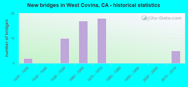
- New bridges - historical statistics
- 21930-1939
- 101950-1959
- 171960-1969
- 181970-1979
- 52010-2019
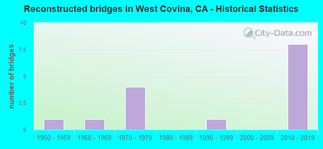
- Reconstructed bridges - Historical Statistics
- 11950-1959
- 11960-1969
- 41970-1979
- 01980-1989
- 11990-1999
- 02000-2009
- 82010-2019
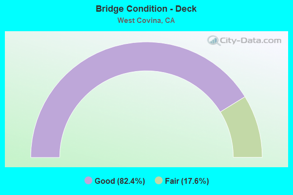
- Bridge Condition - Deck
- 82.4%Good
- 17.6%Fair
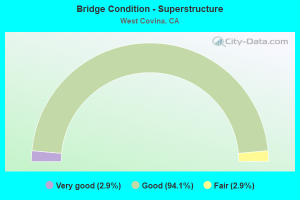
- Bridge Condition - Superstructure
- 2.9%Very good
- 94.1%Good
- 2.9%Fair
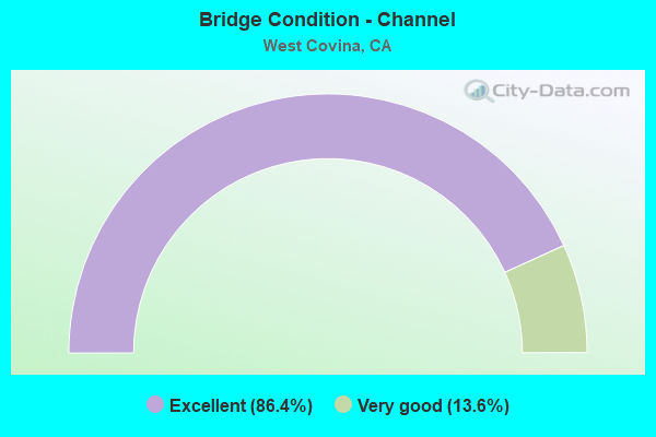
- Bridge Condition - Channel
- 86.4%Excellent
- 13.6%Very good
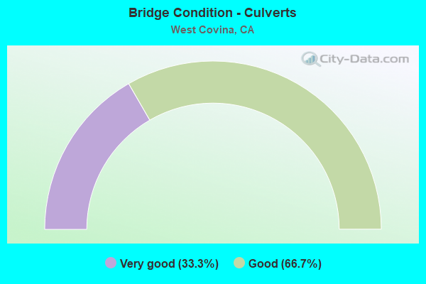
- Bridge Condition - Culverts
- 33.3%Very good
- 66.7%Good
Find on map >> Show street view
Structure Number: 53 0104M, Location: 07-LA-010-37.61-WCOV (Lat: 34.071878, Lng: -117.888228), Route carried "on" structure: Interstate 10, Year Built: 1934, Year Reconstructed: 1975, Status: Open, Structure Length: 0.85m (2.79ft), Average Daily Traffic: 223,000 (year 2012), Truck Traffic: 6%, Average Future Daily Traffic: 282,146 (year 2040), Design Load: HS 20, Features Intersected: CHARTER OAK WASH
Minimum Vertical Clearance: 30+ m (98+ ft), Kilometerpoint: 37.610, Lanes on structure: 10, Base Highway Network: Yes (, Subroute: 1), Owner: State Highway Agency, Approaching Roadway Width: 77.5m (254.3ft), Skew: 30 degrees, Material/Design: Concrete, Design/Construction: Slab, Number Of Spans In Main Unit: 1, Length of Maximum Span: 7.6m (24.9ft), Curb-To-Curb Width: 77.5m (254.3ft), Out-to-Out Width: 78.3m (256.9ft)
Condition: Deck: Good, Superstructure: Good, Substructure: Good, Channel: Very good, Operating Rating: 72.9 metric tons, Method Used To Determine Operating Rating: Load Factor (LF), Inventory Rating: 44.1 metric tons, Method Used To Determine Inventory Rating: Load Factor (LF), Structural Evaluation: Better than present minimum criteria, Deck Geometry: Superior to present desirable criteria, Waterway Adequacy: Equal to present desirable criteria, Approach Roadway Alignment: Equal to present desirable criteria, Designated Inspection Frequency: Every 24 months, Inspection Date: June 2021, Deck Structure Type: Concrete Cast-file-Place
Find on map >> Show street view
Structure Number: 53 0105, Location: 07-LA-010-38.32-WCOV (Lat: 34.071631, Lng: -117.876011), Route carried "on" structure: Interstate 10, Year Built: 1932, Year Reconstructed: 1975, Status: Open, Structure Length: 1.34m (4.40ft), Average Daily Traffic: 223,000 (year 2012), Average Future Daily Traffic: 282,477 (year 2038), Design Load: HS 20, Features Intersected: WALNUT CREEK CHANNEL
Minimum Vertical Clearance: 30+ m (98+ ft), Kilometerpoint: 38.320, Lanes on structure: 11, Base Highway Network: Yes (, Subroute: 1), Owner: State Highway Agency, Approaching Roadway Width: 67.7m (222.1ft), Skew: 33 degrees, Material/Design: Concrete, Design/Construction: Tee Beam, Number Of Spans In Main Unit: 1, Length of Maximum Span: 12.5m (41.0ft), Curb-To-Curb Width: 67.7m (222.1ft), Out-to-Out Width: 69.2m (227.0ft)
Condition: Deck: Good, Superstructure: Good, Substructure: Good, Channel: Very good, Operating Rating: 72.9 metric tons, Method Used To Determine Operating Rating: Load Factor (LF), Inventory Rating: 44.1 metric tons, Method Used To Determine Inventory Rating: Load Factor (LF), Structural Evaluation: Better than present minimum criteria, Deck Geometry: Superior to present desirable criteria, Waterway Adequacy: Equal to present desirable criteria, Approach Roadway Alignment: Equal to present desirable criteria, Designated Inspection Frequency: Every 24 months, Inspection Date: June 2021, Deck Structure Type: Concrete Cast-file-Place
Find on map >> Show street view
Structure Number: 53 066, Location: 07-LA-010-29.55-EMTE (Lat: 34.067800, Lng: -118.026858), Route carried "on" structure: Interstate 10, Year Built: 1956, Year Reconstructed: 2002, Status: Open, Structure Length: 4.68m (15.35ft), Average Daily Traffic: 213,000 (year 2011), Truck Traffic: 6%, Average Future Daily Traffic: 276,892 (year 2043), Design Load: HS 20, Features Intersected: VALLEY BOULEVARD
Minimum Vertical Clearance: 30+ m (98+ ft), Kilometerpoint: 29.550, Lanes on structure: 15, Lanes under structure: 5, Base Highway Network: Yes (, Subroute: 1), Owner: State Highway Agency, Approaching Roadway Width: 60.1m (197.2ft), Skew: 34 degrees, Material/Design: Steel, Design/Construction: Stringer/Multi-beam, Number Of Spans In Main Unit: 2, Length of Maximum Span: 23.4m (76.8ft), Curb-To-Curb Width: 60.1m (197.2ft), Out-to-Out Width: 61.7m (202.4ft)
Condition: Deck: Fair, Superstructure: Good, Substructure: Good, Operating Rating: 43.1 metric tons, Method Used To Determine Operating Rating: Load and Resistance Factor Rating (LRFR) rating reported by rating factor(RF) method using HL-93 loadings, Inventory Rating: 26.6 metric tons, Method Used To Determine Inventory Rating: Load and Resistance Factor Rating (LRFR) rating reported by rating factor(RF) method using HL-93 loadings, Structural Evaluation: Equal to present minimum criteria, Deck Geometry: Somewhat better than minimum adequacy, Underclear: Meets minimum limits, Approach Roadway Alignment: Superior to present desirable criteria, Designated Inspection Frequency: Every 24 months, Other Special Inspection Frequency: Every 48 months, Inspection Date: March 2021, Other Special Inspection Date: September 2019, Deck Structure Type: Concrete Cast-file-Place
Find on map >> Show street view
Structure Number: 53 0667, Location: 07-LA-010-34.28-WCOV (Lat: 34.071639, Lng: -117.946000), Route carried "on" structure: Interstate 10, Year Built: 1956, Year Reconstructed: 2019, Status: Open, Structure Length: 2.19m (7.19ft), Average Daily Traffic: 215,000 (year 2012), Average Future Daily Traffic: 289,216 (year 2038), Design Load: HS 20, Features Intersected: CAMERON AVE
Minimum Vertical Clearance: 30+ m (98+ ft), Kilometerpoint: 34.280, Lanes on structure: 11, Lanes under structure: 4, Base Highway Network: Yes (, Subroute: 1), Owner: State Highway Agency, Approaching Roadway Width: 52.0m (170.6ft), Skew: 31 degrees, Material/Design: Concrete, Design/Construction: Box Beam or Girders - Multiple, Number Of Spans In Main Unit: 1, Length of Maximum Span: 20.7m (67.9ft), Curb-To-Curb Width: 52.0m (170.6ft), Out-to-Out Width: 53.5m (175.5ft)
Condition: Deck: Good, Superstructure: Good, Substructure: Good, Operating Rating: 99.8 metric tons, Method Used To Determine Operating Rating: Load Factor (LF), Inventory Rating: 58.0 metric tons, Method Used To Determine Inventory Rating: Load Factor (LF), Structural Evaluation: Better than present minimum criteria, Deck Geometry: Superior to present desirable criteria, Underclear: Meets minimum limits, Approach Roadway Alignment: Equal to present desirable criteria, Designated Inspection Frequency: Every 24 months, Inspection Date: June 2021, Deck Structure Type: Concrete Cast-file-Place
Find on map >> Show street view
Structure Number: 53 0668, Location: 07-LA-010-34.85-WCOV (Lat: 34.072222, Lng: -117.936392), Route carried "on" structure: Interstate 10, Year Built: 1956, Year Reconstructed: 2019, Status: Open, Structure Length: 2.20m (7.22ft), Average Daily Traffic: 215,000 (year 2012), Average Future Daily Traffic: 289,216 (year 2038), Design Load: HS 20, Features Intersected: SUNSET AVE
Minimum Vertical Clearance: 30+ m (98+ ft), Kilometerpoint: 34.850, Lanes on structure: 12, Lanes under structure: 4, Base Highway Network: Yes (, Subroute: 1), Owner: State Highway Agency, Approaching Roadway Width: 79.8m (261.8ft), Skew: 31 degrees, Material/Design: Concrete, Design/Construction: Box Beam or Girders - Multiple, Number Of Spans In Main Unit: 1, Length of Maximum Span: 20.5m (67.3ft), Curb or Sidewalk Widths: Left: 2.1m (6.9ft), Right: 1.5m (4.9ft), Curb-To-Curb Width: 81.1m (266.1ft), Out-to-Out Width: 86.6m (284.1ft)
Condition: Deck: Good, Superstructure: Good, Substructure: Good, Operating Rating: 45.0 metric tons, Method Used To Determine Operating Rating: Load Factor (LF), Inventory Rating: 32.4 metric tons, Method Used To Determine Inventory Rating: Load Factor (LF), Structural Evaluation: Better than present minimum criteria, Deck Geometry: Superior to present desirable criteria, Underclear: Meets minimum limits, Approach Roadway Alignment: Equal to present desirable criteria, Designated Inspection Frequency: Every 24 months, Inspection Date: June 2021, Deck Structure Type: Concrete Cast-file-Place
Find on map >> Show street view
Structure Number: 53 0669, Location: 07-LA-010-36.48-WCOV (Lat: 34.071925, Lng: -117.907900), Route carried "on" structure: Interstate 10, Year Built: 1975, Year Reconstructed: 2019, Status: Open, Structure Length: 4.90m (16.08ft), Average Daily Traffic: 215,000 (year 2012), Average Future Daily Traffic: 289,216 (year 2038), Design Load: HS 20, Features Intersected: AZUSA AVE
Minimum Vertical Clearance: 30+ m (98+ ft), Kilometerpoint: 36.480, Lanes on structure: 11, Lanes under structure: 8, Base Highway Network: Yes (, Subroute: 1), Owner: State Highway Agency, Approaching Roadway Width: 58.0m (190.3ft), Skew: 30 degrees, Material/Design: Prestressed concrete continuous, Design/Construction: Box Beam or Girders - Multiple, Number Of Spans In Main Unit: 2, Length of Maximum Span: 24.4m (80.1ft), Curb-To-Curb Width: 58.0m (190.3ft), Out-to-Out Width: 59.6m (195.5ft)
Condition: Deck: Good, Superstructure: Good, Substructure: Good, Operating Rating: 40.2 metric tons, Method Used To Determine Operating Rating: Load and Resistance Factor Rating (LRFR) rating reported by rating factor(RF) method using HL-93 loadings, Inventory Rating: 27.5 metric tons, Method Used To Determine Inventory Rating: Load and Resistance Factor Rating (LRFR) rating reported by rating factor(RF) method using HL-93 loadings, Structural Evaluation: Equal to present minimum criteria, Deck Geometry: Superior to present desirable criteria, Underclear: Meets minimum limits, Approach Roadway Alignment: Equal to present desirable criteria, Designated Inspection Frequency: Every 24 months, Inspection Date: June 2021, Deck Structure Type: Concrete Cast-file-Place
Find on map >> Show street view
Structure Number: 53 0671, Location: 07-LA-010-38.97-WCOV (Lat: 34.070325, Lng: -117.865261), Route carried "on" structure: Interstate 10, Year Built: 1975, Year Reconstructed: 2019, Status: Open, Structure Length: 6.59m (21.62ft), Average Daily Traffic: 209,000 (year 2012), Average Future Daily Traffic: 266,494 (year 2040), Design Load: HS 20, Features Intersected: HOLT AVE
Minimum Vertical Clearance: 30+ m (98+ ft), Kilometerpoint: 38.970, Lanes on structure: 11, Lanes under structure: 4, Base Highway Network: Yes (, Subroute: 1), Owner: State Highway Agency, Approaching Roadway Width: 61.2m (200.8ft), Skew: 34 degrees, Material/Design: Prestressed concrete continuous, Design/Construction: Box Beam or Girders - Multiple, Number Of Spans In Main Unit: 2, Length of Maximum Span: 33.6m (110.2ft), Curb-To-Curb Width: 61.2m (200.8ft), Out-to-Out Width: 62.8m (206.0ft)
Condition: Deck: Good, Superstructure: Good, Substructure: Good, Operating Rating: 26.9 metric tons, Method Used To Determine Operating Rating: Load and Resistance Factor Rating (LRFR) rating reported by rating factor(RF) method using HL-93 loadings, Inventory Rating: 20.1 metric tons, Method Used To Determine Inventory Rating: Load and Resistance Factor Rating (LRFR) rating reported by rating factor(RF) method using HL-93 loadings, Structural Evaluation: Somewhat better than minimum adequacy, Deck Geometry: Superior to present desirable criteria, Underclear: Equal to present minimum criteria, Approach Roadway Alignment: Equal to present desirable criteria, Designated Inspection Frequency: Every 24 months, Inspection Date: September 2021, Deck Structure Type: Concrete Cast-file-Place
Find on map >> Show street view
Structure Number: 53 1043, Location: 07-LA-010-35.40-WCOV (Lat: 34.072111, Lng: -117.926917), Route carried "on" structure: Interstate 10, Year Built: 1956, Year Reconstructed: 2019, Status: Open, Structure Length: 3.60m (11.81ft), Average Daily Traffic: 215,000 (year 2012), Average Future Daily Traffic: 289,216 (year 2038), Design Load: HS 20, Features Intersected: VINCENT AVE
Minimum Vertical Clearance: 30+ m (98+ ft), Kilometerpoint: 35.400, Lanes on structure: 11, Lanes under structure: 7, Base Highway Network: Yes (, Subroute: 1), Owner: State Highway Agency, Approaching Roadway Width: 51.9m (170.3ft), Skew: 30 degrees, Material/Design: Concrete continuous, Design/Construction: Box Beam or Girders - Multiple, Number Of Spans In Main Unit: 2, Length of Maximum Span: 19.5m (64.0ft), Curb-To-Curb Width: 51.9m (170.3ft), Out-to-Out Width: 53.4m (175.2ft)
Condition: Deck: Good, Superstructure: Good, Substructure: Good, Operating Rating: 80.7 metric tons, Method Used To Determine Operating Rating: Load Factor (LF), Inventory Rating: 41.8 metric tons, Method Used To Determine Inventory Rating: Load Factor (LF), Structural Evaluation: Better than present minimum criteria, Deck Geometry: Superior to present desirable criteria, Underclear: Meets minimum limits, Approach Roadway Alignment: Equal to present desirable criteria, Designated Inspection Frequency: Every 24 months, Inspection Date: June 2021, Deck Structure Type: Concrete Cast-file-Place
Find on map >> Show street view
Structure Number: 53 1303, Location: 07-LA-010-38.01-WCOV (Lat: 34.072211, Lng: -117.881442), Route carried "on" structure: City street , Year Built: 1975, Status: Open, Structure Length: 7.92m (25.98ft), Average Daily Traffic: 33,700 (year 2012), Truck Traffic: 4%, Average Future Daily Traffic: 36,339 (year 2040), Design Load: HS 20, Features Intersected: INTERSTATE 10, RAMPS, Facility Carried by Structure: BARRANCA ST
Minimum Vertical Clearance: 30+ m (98+ ft), Kilometerpoint: 0.000, Lanes on structure: 6, Lanes under structure: 10, Owner: State Highway Agency, Approaching Roadway Width: 28.0m (91.9ft), Skew: 30 degrees, Material/Design: Prestressed concrete continuous, Design/Construction: Box Beam or Girders - Multiple, Number Of Spans In Main Unit: 2, Length of Maximum Span: 44.3m (145.3ft), Curb or Sidewalk Widths: Left: 1.5m (4.9ft), Right: 1.5m (4.9ft), Curb-To-Curb Width: 28.0m (91.9ft), Out-to-Out Width: 32.9m (107.9ft)
Condition: Deck: Good, Superstructure: Good, Substructure: Good, Operating Rating: 43.7 metric tons, Method Used To Determine Operating Rating: Load and Resistance Factor Rating (LRFR) rating reported by rating factor(RF) method using HL-93 loadings, Inventory Rating: 27.2 metric tons, Method Used To Determine Inventory Rating: Load and Resistance Factor Rating (LRFR) rating reported by rating factor(RF) method using HL-93 loadings, Structural Evaluation: Equal to present minimum criteria, Deck Geometry: Superior to present desirable criteria, Underclear: High priority of corrective action, Approach Roadway Alignment: Equal to present desirable criteria, Designated Inspection Frequency: Every 24 months, Inspection Date: August 2021, Deck Structure Type: Concrete Cast-file-Place
Find on map >> Show street view
Structure Number: 53 1351M, Location: 07-LA-010-34.00-WCOV (Lat: 34.071081, Lng: -117.951147), Route carried "on" structure: Interstate 10, Year Built: 1956, Status: Open, Structure Length: 0.76m (2.49ft), Average Daily Traffic: 215,000 (year 2012), Average Future Daily Traffic: 286,467 (year 2040), Features Intersected: MEEKER AVE STORM DRAIN
Minimum Vertical Clearance: 30+ m (98+ ft), Kilometerpoint: 34.000, Lanes on structure: 8, Base Highway Network: Yes (, Subroute: 1), Owner: State Highway Agency, Approaching Roadway Width: 39.6m (129.9ft), Skew: 32 degrees, Material/Design: Concrete, Design/Construction: Culvert, Number Of Spans In Main Unit: 4, Length of Maximum Span: 1.8m (5.9ft), Curb-To-Curb Width: 39.6m (129.9ft), Out-to-Out Width: 40.2m (131.9ft)
Condition: Channel: Excellent, Culverts: Good, Operating Rating: 54.1 metric tons, Method Used To Determine Operating Rating: Field evaluation and documented engineering judgment, Inventory Rating: 32.4 metric tons, Method Used To Determine Inventory Rating: Field evaluation and documented engineering judgment, Structural Evaluation: Better than present minimum criteria, Deck Geometry: Superior to present desirable criteria, Waterway Adequacy: Equal to present desirable criteria, Approach Roadway Alignment: Equal to present desirable criteria, Designated Inspection Frequency: Every 24 months, Inspection Date: August 2021
Find on map >> Show street view
Structure Number: 53 1352M, Location: 07-LA-010-35.81-WCOV (Lat: 34.072089, Lng: -117.919961), Route carried "on" structure: Interstate 10, Year Built: 1956, Year Reconstructed: 1975, Status: Open, Structure Length: 0.88m (2.89ft), Average Daily Traffic: 215,000 (year 2012), Truck Traffic: 10%, Average Future Daily Traffic: 286,467 (year 2041), Features Intersected: GLENDORA STORM DRAIN
Minimum Vertical Clearance: 30+ m (98+ ft), Kilometerpoint: 35.810, Lanes on structure: 10, Base Highway Network: Yes (, Subroute: 1), Owner: State Highway Agency, Approaching Roadway Width: 46.4m (152.2ft), Skew: 34 degrees, Material/Design: Concrete, Design/Construction: Culvert, Number Of Spans In Main Unit: 4, Length of Maximum Span: 1.5m (4.9ft), Curb-To-Curb Width: 46.4m (152.2ft), Out-to-Out Width: 47.5m (155.8ft)
Condition: Channel: Very good, Culverts: Good, Operating Rating: 54.1 metric tons, Method Used To Determine Operating Rating: Field evaluation and documented engineering judgment, Inventory Rating: 32.4 metric tons, Method Used To Determine Inventory Rating: Field evaluation and documented engineering judgment, Structural Evaluation: Better than present minimum criteria, Deck Geometry: Superior to present desirable criteria, Waterway Adequacy: Equal to present desirable criteria, Approach Roadway Alignment: Equal to present desirable criteria, Designated Inspection Frequency: Every 24 months, Inspection Date: August 2021
Find on map >> Show street view
Structure Number: 53 1528, Location: 07-LA-010-38.51-WCOV (Lat: 34.071536, Lng: -117.872497), Route carried "on" structure: Interstate 10, Year Built: 1961, Year Reconstructed: 2019, Status: Open, Structure Length: 2.41m (7.91ft), Average Daily Traffic: 209,000 (year 2012), Truck Traffic: 6%, Average Future Daily Traffic: 275,965 (year 2040), Design Load: HS 20, Features Intersected: GRAND AVE
Minimum Vertical Clearance: 30+ m (98+ ft), Kilometerpoint: 38.510, Lanes on structure: 11, Lanes under structure: 4, Base Highway Network: Yes (, Subroute: 1), Owner: State Highway Agency, Approaching Roadway Width: 63.6m (208.7ft), Skew: 30 degrees, Material/Design: Concrete continuous, Design/Construction: Tee Beam, Number Of Spans In Main Unit: 2, Length of Maximum Span: 11.9m (39.0ft), Curb-To-Curb Width: 63.6m (208.7ft), Out-to-Out Width: 65.6m (215.2ft)
Condition: Deck: Good, Superstructure: Good, Substructure: Good, Operating Rating: 38.9 metric tons, Method Used To Determine Operating Rating: Load and Resistance Factor Rating (LRFR) rating reported by rating factor(RF) method using HL-93 loadings, Inventory Rating: 30.1 metric tons, Method Used To Determine Inventory Rating: Load and Resistance Factor Rating (LRFR) rating reported by rating factor(RF) method using HL-93 loadings, Structural Evaluation: Better than present minimum criteria, Deck Geometry: Superior to present desirable criteria, Underclear: Meets minimum limits, Approach Roadway Alignment: Equal to present desirable criteria, Designated Inspection Frequency: Every 24 months, Inspection Date: September 2021, Deck Structure Type: Concrete Cast-file-Place
Find on map >> Show street view
Structure Number: 53 2271, Location: 07-LA-010-36.98-WCOV (Lat: 34.071858, Lng: -117.899150), Route carried "on" structure: Interstate 10, Year Built: 1975, Year Reconstructed: 2019, Status: Open, Structure Length: 4.45m (14.60ft), Average Daily Traffic: 223,000 (year 2012), Truck Traffic: 10%, Average Future Daily Traffic: 280,274 (year 2040), Design Load: HS 20, Features Intersected: HOLLENBECK STREET
Minimum Vertical Clearance: 30+ m (98+ ft), Kilometerpoint: 36.980, Lanes on structure: 10, Lanes under structure: 4, Base Highway Network: Yes (, Subroute: 1), Owner: State Highway Agency, Approaching Roadway Width: 55.2m (181.1ft), Skew: 30 degrees, Material/Design: Concrete continuous, Design/Construction: Box Beam or Girders - Multiple, Number Of Spans In Main Unit: 3, Length of Maximum Span: 25.6m (84.0ft), Curb-To-Curb Width: 55.2m (181.1ft), Out-to-Out Width: 56.4m (185.0ft)
Condition: Deck: Fair, Superstructure: Good, Substructure: Good, Operating Rating: 68.0 metric tons, Method Used To Determine Operating Rating: Load and Resistance Factor Rating (LRFR) rating reported by rating factor(RF) method using HL-93 loadings, Inventory Rating: 52.5 metric tons, Method Used To Determine Inventory Rating: Load and Resistance Factor Rating (LRFR) rating reported by rating factor(RF) method using HL-93 loadings, Structural Evaluation: Better than present minimum criteria, Deck Geometry: Superior to present desirable criteria, Underclear: Somewhat better than minimum adequacy, Approach Roadway Alignment: Equal to present desirable criteria, Designated Inspection Frequency: Every 24 months, Inspection Date: August 2021, Deck Structure Type: Concrete Cast-file-Place
Find on map >> Show street view
Structure Number: 53 2372, Location: 07-LA-010-34.46-WCOV (Lat: 34.071944, Lng: -117.942861), Route carried "on" structure: Interstate 10, Year Built: 1975, Year Reconstructed: 2019, Status: Open, Structure Length: 6.60m (21.65ft), Average Daily Traffic: 215,000 (year 2012), Truck Traffic: 10%, Average Future Daily Traffic: 286,467 (year 2040), Design Load: HS 20+Mod, Features Intersected: W COVINA PARKWAY
Minimum Vertical Clearance: 30+ m (98+ ft), Kilometerpoint: 34.460, Lanes on structure: 10, Lanes under structure: 4, Base Highway Network: Yes (, Subroute: 1), Owner: State Highway Agency, Approaching Roadway Width: 59.0m (193.6ft), Skew: 34 degrees, Material/Design: Prestressed concrete continuous, Design/Construction: Box Beam or Girders - Multiple, Number Of Spans In Main Unit: 2, Length of Maximum Span: 33.2m (108.9ft), Curb-To-Curb Width: 59.0m (193.6ft), Out-to-Out Width: 62.0m (203.4ft)
Condition: Deck: Fair, Superstructure: Good, Substructure: Good, Operating Rating: 82.5 metric tons, Method Used To Determine Operating Rating: Load Factor (LF), Inventory Rating: 32.4 metric tons, Method Used To Determine Inventory Rating: Load Factor (LF), Structural Evaluation: Better than present minimum criteria, Deck Geometry: Superior to present desirable criteria, Underclear: Somewhat better than minimum adequacy, Approach Roadway Alignment: Equal to present desirable criteria, Designated Inspection Frequency: Every 24 months, Inspection Date: August 2021, Deck Structure Type: Concrete Cast-file-Place
Find on map >> Show street view
Structure Number: 53 2374K, Location: 07-LA-010-38.40-WCOV (Lat: 34.072489, Lng: -117.873800), Route carried "on" structure: Ramp Interstate 10, Year Built: 1975, Status: Open, Structure Length: 3.52m (11.55ft), Average Daily Traffic: 11,800 (year 2012), Truck Traffic: 2%, Average Future Daily Traffic: 12,826 (year 2040), Design Load: HS 20, Features Intersected: N GARVEY AVENUE
Minimum Vertical Clearance: 30+ m (98+ ft), Kilometerpoint: 38.400, Lanes on structure: 2, Lanes under structure: 2, Owner: State Highway Agency, Approaching Roadway Width: 9.8m (32.2ft), Material/Design: Prestressed concrete, Design/Construction: Box Beam or Girders - Multiple, Number Of Spans In Main Unit: 1, Length of Maximum Span: 35.2m (115.5ft), Curb-To-Curb Width: 9.8m (32.2ft), Out-to-Out Width: 10.4m (34.1ft)
Condition: Deck: Fair, Superstructure: Good, Substructure: Good, Operating Rating: 46.0 metric tons, Method Used To Determine Operating Rating: Load and Resistance Factor Rating (LRFR) rating reported by rating factor(RF) method using HL-93 loadings, Inventory Rating: 32.4 metric tons, Method Used To Determine Inventory Rating: Load and Resistance Factor Rating (LRFR) rating reported by rating factor(RF) method using HL-93 loadings, Structural Evaluation: Better than present minimum criteria, Deck Geometry: Equal to present minimum criteria, Underclear: Meets minimum limits, Approach Roadway Alignment: Equal to present desirable criteria, Designated Inspection Frequency: Every 24 months, Inspection Date: August 2021, Deck Structure Type: Concrete Cast-file-Place
Find on map >> Show street view
Structure Number: 53 2375K, Location: 07-LA-010-38.41-WCOV (Lat: 34.072739, Lng: -117.873558), Route carried "on" structure: Ramp Interstate 10, Year Built: 1975, Status: Open, Structure Length: 5.30m (17.39ft), Average Daily Traffic: 3,800 (year 2012), Truck Traffic: 2%, Average Future Daily Traffic: 4,276 (year 2042), Design Load: HS 20, Features Intersected: N GARVEY AVENUE
Minimum Vertical Clearance: 30+ m (98+ ft), Kilometerpoint: 38.410, Lanes on structure: 2, Lanes under structure: 2, Owner: State Highway Agency, Approaching Roadway Width: 9.8m (32.2ft), Skew: 9 degrees, Material/Design: Concrete, Design/Construction: Box Beam or Girders - Multiple, Number Of Spans In Main Unit: 2, Length of Maximum Span: 29.8m (97.8ft), Curb-To-Curb Width: 9.8m (32.2ft), Out-to-Out Width: 10.4m (34.1ft)
Condition: Deck: Fair, Superstructure: Good, Substructure: Good, Operating Rating: 99.8 metric tons, Method Used To Determine Operating Rating: Load Factor (LF), Inventory Rating: 59.8 metric tons, Method Used To Determine Inventory Rating: Load Factor (LF), Structural Evaluation: Better than present minimum criteria, Deck Geometry: Equal to present minimum criteria, Underclear: Meets minimum limits, Approach Roadway Alignment: Equal to present desirable criteria, Designated Inspection Frequency: Every 24 months, Inspection Date: August 2021, Deck Structure Type: Concrete Cast-file-Place
Find on map >> Show street view
Structure Number: 53 304, Location: 07-LA-005-3.44-NRW (Lat: 33.902167, Lng: -118.061000), Route carried "on" structure: Interstate 5, Year Built: 2016, Status: Open, Structure Length: 8.22m (26.97ft), Average Daily Traffic: 175,000 (year 2016), Truck Traffic: 5%, Average Future Daily Traffic: 245,000 (year 2041), Design Load: HL 93, Features Intersected: ROSECRANS AVENUE
Minimum Vertical Clearance: 30+ m (98+ ft), Kilometerpoint: 3.440, Lanes on structure: 6, Lanes under structure: 7, Base Highway Network: Yes (, Subroute: 1), Owner: State Highway Agency, Approaching Roadway Width: 61.0m (200.1ft), Skew: 35 degrees, Material/Design: Prestressed concrete, Design/Construction: Box Beam or Girders - Multiple, Number Of Spans In Main Unit: 2, Length of Maximum Span: 41.5m (136.2ft), Curb-To-Curb Width: 61.0m (200.1ft), Out-to-Out Width: 62.5m (205.1ft)
Condition: Deck: Good, Superstructure: Good, Substructure: Good, Operating Rating: 42.1 metric tons, Method Used To Determine Operating Rating: Assigned ratings based on Load and Resistance Factor Design (LRFD) reported by rating factor (RF) using HL93 loadings, Inventory Rating: 32.4 metric tons, Method Used To Determine Inventory Rating: Assigned ratings based on Load and Resistance Factor Design (LRFD) reported by rating factor (RF) using HL93 loadings, Structural Evaluation: Better than present minimum criteria, Deck Geometry: Superior to present desirable criteria, Underclear: Somewhat better than minimum adequacy, Approach Roadway Alignment: Equal to present desirable criteria, Designated Inspection Frequency: Every 24 months, Inspection Date: March 2020, Deck Structure Type: Concrete Cast-file-Place
Find on map >> Show street view
Structure Number: 53 3047S, Location: 07-LA-010-34.29-WCOV (Lat: 34.071556, Lng: -117.945972), Route carried "on" structure: Ramp Interstate 10, Year Built: 2017, Status: Open, Structure Length: 2.25m (7.38ft), Average Daily Traffic: 8,000 (year 2021), Truck Traffic: 2%, Average Future Daily Traffic: 12,500 (year 2040), Design Load: HL 93, Features Intersected: CAMERON AVE
Minimum Vertical Clearance: 30+ m (98+ ft), Kilometerpoint: 34.290, Lanes on structure: 1, Lanes under structure: 4, Base Highway Network: Yes (, Subroute: 1), Owner: State Highway Agency, Approaching Roadway Width: 7.3m (24.0ft), Skew: 1 degrees, Material/Design: Concrete, Design/Construction: Box Beam or Girders - Multiple, Number Of Spans In Main Unit: 1, Length of Maximum Span: 21.3m (69.9ft), Curb-To-Curb Width: 7.3m (24.0ft), Out-to-Out Width: 8.2m (26.9ft)
Condition: Deck: Good, Superstructure: Good, Substructure: Good, Operating Rating: 42.1 metric tons, Method Used To Determine Operating Rating: Assigned ratings based on Load and Resistance Factor Design (LRFD) reported by rating factor (RF) using HL93 loadings, Inventory Rating: 32.4 metric tons, Method Used To Determine Inventory Rating: Assigned ratings based on Load and Resistance Factor Design (LRFD) reported by rating factor (RF) using HL93 loadings, Structural Evaluation: Better than present minimum criteria, Deck Geometry: Better than present minimum criteria, Underclear: Meets minimum limits, Approach Roadway Alignment: Equal to present desirable criteria, Designated Inspection Frequency: Every 24 months, Inspection Date: April 2021, Deck Structure Type: Concrete Cast-file-Place
Find on map >> Show street view
Structure Number: 53 3049S, Location: 07-LA-010-35.40-WCOV (Lat: 34.072028, Lng: -117.927000), Route carried "on" structure: Ramp Interstate 10, Year Built: 2017, Status: Open, Structure Length: 3.73m (12.24ft), Average Daily Traffic: 5,000 (year 2021), Truck Traffic: 2%, Average Future Daily Traffic: 6,467 (year 2040), Design Load: HL 93, Features Intersected: VINCENT AVE
Minimum Vertical Clearance: 30+ m (98+ ft), Kilometerpoint: 35.400, Lanes on structure: 1, Lanes under structure: 7, Base Highway Network: Yes (, Subroute: 1), Owner: State Highway Agency, Approaching Roadway Width: 7.3m (24.0ft), Material/Design: Concrete continuous, Design/Construction: Box Beam or Girders - Multiple, Number Of Spans In Main Unit: 2, Length of Maximum Span: 20.5m (67.3ft), Curb-To-Curb Width: 7.3m (24.0ft), Out-to-Out Width: 8.2m (26.9ft)
Condition: Deck: Good, Superstructure: Good, Substructure: Good, Operating Rating: 42.1 metric tons, Method Used To Determine Operating Rating: Assigned ratings based on Load and Resistance Factor Design (LRFD) reported by rating factor (RF) using HL93 loadings, Inventory Rating: 32.4 metric tons, Method Used To Determine Inventory Rating: Assigned ratings based on Load and Resistance Factor Design (LRFD) reported by rating factor (RF) using HL93 loadings, Structural Evaluation: Better than present minimum criteria, Deck Geometry: Better than present minimum criteria, Underclear: Meets minimum limits, Approach Roadway Alignment: Equal to present desirable criteria, Designated Inspection Frequency: Every 24 months, Inspection Date: April 2021, Deck Structure Type: Concrete Cast-file-Place
Find on map >> Show street view
Structure Number: 53C0033, Location: AT VALINDA AVE (Lat: 34.066950, Lng: -117.925469), Route carried "on" structure: City street Q911, Year Built: 1961, Year Reconstructed: 1964, Status: Open, Structure Length: 1.73m (5.68ft), Average Daily Traffic: 9,348 (year 2014), Truck Traffic: 1%, Average Future Daily Traffic: 10,751 (year 2042), Design Load: HS 20, Features Intersected: WALNUT CRK, Facility Carried by Structure: GLENDORA AVE
Minimum Vertical Clearance: 30+ m (98+ ft), Kilometerpoint: 0.000, Lanes on structure: 5, Owner: City or Municipal Highway Agency, Approaching Roadway Width: 24.3m (79.7ft), Skew: 2 degrees, Material/Design: Prestressed concrete, Design/Construction: Box Beam or Girders - Multiple, Number Of Spans In Main Unit: 1, Length of Maximum Span: 15.2m (49.9ft), Curb or Sidewalk Widths: Left: 1.5m (4.9ft), Right: 1.4m (4.6ft), Curb-To-Curb Width: 24.3m (79.7ft), Out-to-Out Width: 48.8m (160.1ft)
Condition: Deck: Good, Superstructure: Good, Substructure: Good, Channel: Excellent, Operating Rating: 57.0 metric tons, Method Used To Determine Operating Rating: Load Factor (LF), Inventory Rating: 34.3 metric tons, Method Used To Determine Inventory Rating: Load Factor (LF), Structural Evaluation: Better than present minimum criteria, Deck Geometry: Superior to present desirable criteria, Waterway Adequacy: Superior to present desirable criteria, Approach Roadway Alignment: Better than present minimum criteria, Designated Inspection Frequency: Every 48 months, Inspection Date: November 2021, Deck Structure Type: Concrete Cast-file-Place, Wearing Surface/Protective System: Wearing Surface: Bituminous
Find on map >> Show street view
Structure Number: 53C0128, Location: 0.1MI E/O CITRUS ST (Lat: 34.071283, Lng: -117.888214), Route carried "on" structure: City street Q940, Year Built: 1956, Year Reconstructed: 1972, Status: Open, Structure Length: 1.01m (3.31ft), Average Daily Traffic: 16,848 (year 2014), Truck Traffic: 1%, Average Future Daily Traffic: 20,218 (year 2042), Design Load: HS 20, Features Intersected: CHARTER OAK WASH, Facility Carried by Structure: GARVEY AVE S
Minimum Vertical Clearance: 30+ m (98+ ft), Kilometerpoint: 0.000, Lanes on structure: 2, Owner: City or Municipal Highway Agency, Approaching Roadway Width: 12.6m (41.3ft), Skew: 3 degrees, Material/Design: Concrete, Design/Construction: Slab, Number Of Spans In Main Unit: 1, Length of Maximum Span: 7.3m (24.0ft), Curb or Sidewalk Widths: Left: 1.5m (4.9ft), Right: 1.5m (4.9ft), Curb-To-Curb Width: 15.1m (49.5ft), Out-to-Out Width: 18.4m (60.4ft)
Condition: Deck: Good, Superstructure: Good, Substructure: Good, Channel: Excellent, Operating Rating: 70.2 metric tons, Method Used To Determine Operating Rating: Load Factor (LF), Inventory Rating: 42.0 metric tons, Method Used To Determine Inventory Rating: Load Factor (LF), Structural Evaluation: Better than present minimum criteria, Deck Geometry: Superior to present desirable criteria, Waterway Adequacy: Superior to present desirable criteria, Approach Roadway Alignment: Better than present minimum criteria, Designated Inspection Frequency: Every 48 months, Inspection Date: November 2021, Deck Structure Type: Concrete Cast-file-Place
Find on map >> Show street view
Structure Number: 53C0191, Location: 100FT S/O I-10 FWY (Lat: 34.070747, Lng: -117.881175), Route carried "on" structure: City street L380, Year Built: 1975, Status: Open, Structure Length: 2.04m (6.69ft), Average Daily Traffic: 15,526 (year 2018), Truck Traffic: 1%, Average Future Daily Traffic: 18,631 (year 2042), Design Load: HS 20+Mod, Features Intersected: WALNUT CRK, Facility Carried by Structure: BARRANCA ST
Minimum Vertical Clearance: 30.47m (99.97ft), Kilometerpoint: 0.000, Lanes on structure: 5, Owner: City or Municipal Highway Agency, Approaching Roadway Width: 19.4m (63.6ft), Material/Design: Prestressed concrete, Design/Construction: Stringer/Multi-beam, Number Of Spans In Main Unit: 1, Length of Maximum Span: 19.8m (65.0ft), Curb or Sidewalk Widths: Left: 1.5m (4.9ft), Right: 1.5m (4.9ft), Curb-To-Curb Width: 19.5m (64.0ft), Out-to-Out Width: 23.1m (75.8ft)
Condition: Deck: Good, Superstructure: Good, Substructure: Good, Channel: Excellent, Operating Rating: 48.6 metric tons, Method Used To Determine Operating Rating: Load Factor (LF), Inventory Rating: 29.5 metric tons, Method Used To Determine Inventory Rating: Load Factor (LF), Structural Evaluation: Better than present minimum criteria, Deck Geometry: Meets minimum limits, Waterway Adequacy: Superior to present desirable criteria, Approach Roadway Alignment: Better than present minimum criteria, Designated Inspection Frequency: Every 24 months, Inspection Date: November 2021, Deck Structure Type: Concrete Cast-file-Place
Find on map >> Show street view
Structure Number: 53C0449, Location: 0.2MI N/O CAMERON AVE (Lat: 34.065419, Lng: -117.907658), Route carried "on" structure: City street L379, Year Built: 1967, Status: Open, Structure Length: 1.62m (5.31ft), Average Daily Traffic: 42,405 (year 2018), Truck Traffic: 10%, Average Future Daily Traffic: 50,886 (year 2042), Design Load: HS 20, Features Intersected: WALNUT CRK, Facility Carried by Structure: AZUSA AVE
Minimum Vertical Clearance: 30.47m (99.97ft), Kilometerpoint: 0.000, Lanes on structure: 4, Owner: City or Municipal Highway Agency, Approaching Roadway Width: 21.9m (71.9ft), Skew: 22 degrees, Material/Design: Concrete, Design/Construction: Tee Beam, Number Of Spans In Main Unit: 1, Length of Maximum Span: 14.9m (48.9ft), Curb or Sidewalk Widths: Left: 1.4m (4.6ft), Right: 1.4m (4.6ft), Curb-To-Curb Width: 23.4m (76.8ft), Out-to-Out Width: 29.0m (95.1ft)
Condition: Deck: Good, Superstructure: Good, Substructure: Good, Channel: Excellent, Operating Rating: 58.3 metric tons, Method Used To Determine Operating Rating: Load Factor (LF), Inventory Rating: 35.0 metric tons, Method Used To Determine Inventory Rating: Load Factor (LF), Structural Evaluation: Better than present minimum criteria, Deck Geometry: Superior to present desirable criteria, Waterway Adequacy: Superior to present desirable criteria, Approach Roadway Alignment: Equal to present desirable criteria, Designated Inspection Frequency: Every 48 months, Inspection Date: November 2021, Deck Structure Type: Concrete Cast-file-Place
Find on map >> Show street view
Structure Number: 53C0494, Location: 0.3MI S/O I-10 FWY (Lat: 34.067375, Lng: -117.926889), Route carried "on" structure: City street L378, Year Built: 1960, Year Reconstructed: 1975, Status: Open, Structure Length: 1.52m (4.99ft), Average Daily Traffic: 30,995 (year 2014), Truck Traffic: 3%, Average Future Daily Traffic: 37,194 (year 2042), Design Load: H 20, Features Intersected: WALNUT CRK, Facility Carried by Structure: VINCENT AVE
Minimum Vertical Clearance: 30+ m (98+ ft), Kilometerpoint: 0.000, Lanes on structure: 7, Owner: City or Municipal Highway Agency, Approaching Roadway Width: 27.4m (89.9ft), Skew: 21 degrees, Material/Design: Concrete, Design/Construction: Slab, Number Of Spans In Main Unit: 1, Length of Maximum Span: 14.6m (47.9ft), Curb or Sidewalk Widths: Left: 1.5m (4.9ft), Right: 1.5m (4.9ft), Curb-To-Curb Width: 27.1m (88.9ft), Out-to-Out Width: 32.2m (105.6ft)
Condition: Deck: Good, Superstructure: Good, Substructure: Good, Channel: Excellent, Operating Rating: 68.0 metric tons, Method Used To Determine Operating Rating: Load Factor (LF), Inventory Rating: 40.8 metric tons, Method Used To Determine Inventory Rating: Load Factor (LF), Structural Evaluation: Better than present minimum criteria, Deck Geometry: Somewhat better than minimum adequacy, Waterway Adequacy: Superior to present desirable criteria, Approach Roadway Alignment: Better than present minimum criteria, Designated Inspection Frequency: Every 48 months, Inspection Date: November 2021, Deck Structure Type: Concrete Cast-file-Place, Wearing Surface/Protective System: Wearing Surface: Bituminous
Find on map >> Show street view
Structure Number: 53C0496, Location: 200FT S/O W COVINA PKWY (Lat: 34.068081, Lng: -117.938794), Route carried "on" structure: City street L374, Year Built: 1962, Status: Open, Structure Length: 2.50m (8.20ft), Average Daily Traffic: 31,764 (year 2014), Truck Traffic: 1%, Average Future Daily Traffic: 38,116 (year 2042), Design Load: HS 20, Features Intersected: WALNUT CRK, Facility Carried by Structure: SUNSET AVE
Minimum Vertical Clearance: 30+ m (98+ ft), Kilometerpoint: 0.000, Lanes on structure: 4, Owner: City or Municipal Highway Agency, Approaching Roadway Width: 24.4m (80.1ft), Skew: 25 degrees, Material/Design: Prestressed concrete, Design/Construction: Box Beam or Girders - Multiple, Number Of Spans In Main Unit: 1, Length of Maximum Span: 21.3m (69.9ft), Curb or Sidewalk Widths: Left: 1.5m (4.9ft), Right: 1.5m (4.9ft), Curb-To-Curb Width: 20.1m (65.9ft), Out-to-Out Width: 27.5m (90.2ft)
Condition: Deck: Good, Superstructure: Good, Substructure: Good, Channel: Excellent, Operating Rating: 69.3 metric tons, Method Used To Determine Operating Rating: Load Factor (LF), Inventory Rating: 41.5 metric tons, Method Used To Determine Inventory Rating: Load Factor (LF), Structural Evaluation: Better than present minimum criteria, Deck Geometry: Better than present minimum criteria, Waterway Adequacy: Superior to present desirable criteria, Approach Roadway Alignment: Equal to present desirable criteria, Designated Inspection Frequency: Every 48 months, Inspection Date: November 2021, Deck Structure Type: Concrete Cast-file-Place, Wearing Surface/Protective System: Wearing Surface: Bituminous
Find on map >> Show street view
Structure Number: 53C051, Location: 0.3MI S/O I-10 FWY (Lat: 34.117756, Lng: -117.872514), Route carried "on" structure: City street L381, Year Built: 1960, Status: Open, Structure Length: 1.01m (3.31ft), Average Daily Traffic: 25,736 (year 2017), Truck Traffic: 4%, Average Future Daily Traffic: 36,932 (year 2040), Design Load: HS 20, Features Intersected: BIG DALTON WASH, Facility Carried by Structure: GRAND AVE
Minimum Vertical Clearance: 30+ m (98+ ft), Kilometerpoint: 0.000, Lanes on structure: 4, Owner: City or Municipal Highway Agency, Approaching Roadway Width: 19.5m (64.0ft), Skew: 20 degrees, Material/Design: Concrete, Design/Construction: Slab, Number Of Spans In Main Unit: 1, Length of Maximum Span: 9.1m (29.9ft), Curb or Sidewalk Widths: Left: 1.6m (5.2ft), Right: 1.6m (5.2ft), Curb-To-Curb Width: 19.5m (64.0ft), Out-to-Out Width: 28.0m (91.9ft)
Condition: Deck: Good, Superstructure: Good, Substructure: Good, Channel: Excellent, Operating Rating: 86.5 metric tons, Method Used To Determine Operating Rating: Load Factor (LF), Inventory Rating: 51.8 metric tons, Method Used To Determine Inventory Rating: Load Factor (LF), Structural Evaluation: Better than present minimum criteria, Deck Geometry: Better than present minimum criteria, Waterway Adequacy: Superior to present desirable criteria, Approach Roadway Alignment: Equal to present desirable criteria, Designated Inspection Frequency: Every 48 months, Inspection Date: January 2021, Deck Structure Type: Concrete Cast-file-Place, Wearing Surface/Protective System: Wearing Surface: Bituminous
Find on map >> Show street view
Structure Number: 53C0513, Location: 0.5MI S/O I-10 FWY (Lat: 34.068978, Lng: -117.890014), Route carried "on" structure: City street L532, Year Built: 1962, Status: Open, Structure Length: 1.49m (4.89ft), Average Daily Traffic: 14,238 (year 2014), Truck Traffic: 1%, Average Future Daily Traffic: 16,374 (year 2042), Design Load: HS 20, Features Intersected: WALNUT CRK, Facility Carried by Structure: CITRUS ST
Minimum Vertical Clearance: 30+ m (98+ ft), Kilometerpoint: 0.000, Lanes on structure: 4, Owner: City or Municipal Highway Agency, Approaching Roadway Width: 18.3m (60.0ft), Material/Design: Prestressed concrete, Design/Construction: Box Beam or Girders - Multiple, Number Of Spans In Main Unit: 1, Length of Maximum Span: 13.6m (44.6ft), Curb or Sidewalk Widths: Left: 1.5m (4.9ft), Right: 1.5m (4.9ft), Curb-To-Curb Width: 18.4m (60.4ft), Out-to-Out Width: 22.0m (72.2ft)
Condition: Deck: Good, Superstructure: Good, Substructure: Good, Channel: Excellent, Operating Rating: 70.3 metric tons, Method Used To Determine Operating Rating: Load Factor (LF), Inventory Rating: 42.1 metric tons, Method Used To Determine Inventory Rating: Load Factor (LF), Structural Evaluation: Better than present minimum criteria, Deck Geometry: Somewhat better than minimum adequacy, Waterway Adequacy: Superior to present desirable criteria, Approach Roadway Alignment: Equal to present desirable criteria, Designated Inspection Frequency: Every 48 months, Inspection Date: November 2021, Deck Structure Type: Concrete Cast-file-Place, Wearing Surface/Protective System: Wearing Surface: Bituminous
Find on map >> Show street view
Structure Number: 53C069, Location: 0.5MI N/O TELEGRAPH RD (Lat: 33.946428, Lng: -118.046369), Route carried "on" structure: County highway L095, Year Built: 1960, Status: Open, Structure Length: 1.34m (4.40ft), Average Daily Traffic: 26,049 (year 2012), Truck Traffic: 3%, Average Future Daily Traffic: 31,259 (year 2040), Features Intersected: SORENSON DRN, Facility Carried by Structure: CARMENITA RD
Minimum Vertical Clearance: 30.47m (99.97ft), Kilometerpoint: 0.000, Lanes on structure: 4, Owner: County Highway Agency, Approaching Roadway Width: 20.1m (65.9ft), Skew: 24 degrees, Material/Design: Concrete, Design/Construction: Culvert, Number Of Spans In Main Unit: 3, Length of Maximum Span: 3.0m (9.8ft), Curb or Sidewalk Widths: Left: 1.6m (5.2ft), Right: 1.5m (4.9ft), Curb-To-Curb Width: 20.0m (65.6ft), Out-to-Out Width: 28.0m (91.9ft)
Condition: Channel: Excellent, Culverts: Very good, Operating Rating: 40.5 metric tons, Method Used To Determine Operating Rating: Field evaluation and documented engineering judgment, Inventory Rating: 24.3 metric tons, Method Used To Determine Inventory Rating: Field evaluation and documented engineering judgment, Structural Evaluation: Equal to present minimum criteria, Deck Geometry: Better than present minimum criteria, Waterway Adequacy: Superior to present desirable criteria, Approach Roadway Alignment: Equal to present desirable criteria, Designated Inspection Frequency: Every 24 months, Inspection Date: October 2020
Find on map >> Show street view
Structure Number: 53C0698, Location: 100FT S/O W COVINA PKWY (Lat: 34.068206, Lng: -117.930292), Route carried "on" structure: City street Q947, Year Built: 1961, Status: Open, Structure Length: 1.84m (6.04ft), Average Daily Traffic: 7,440 (year 2014), Average Future Daily Traffic: 8,556 (year 2042), Design Load: HS 20, Features Intersected: WALNUT CRK, Facility Carried by Structure: CALIFORNIA AVE
Minimum Vertical Clearance: 30+ m (98+ ft), Kilometerpoint: 0.000, Lanes on structure: 3, Owner: City or Municipal Highway Agency, Approaching Roadway Width: 12.2m (40.0ft), Skew: 3 degrees, Material/Design: Prestressed concrete, Design/Construction: Box Beam or Girders - Multiple, Number Of Spans In Main Unit: 1, Length of Maximum Span: 17.7m (58.1ft), Curb or Sidewalk Widths: Left: 1.7m (5.6ft), Right: 1.5m (4.9ft), Curb-To-Curb Width: 14.7m (48.2ft), Out-to-Out Width: 18.1m (59.4ft)
Condition: Deck: Good, Superstructure: Good, Substructure: Good, Channel: Excellent, Operating Rating: 68.7 metric tons, Method Used To Determine Operating Rating: Load Factor (LF), Inventory Rating: 41.1 metric tons, Method Used To Determine Inventory Rating: Load Factor (LF), Structural Evaluation: Better than present minimum criteria, Deck Geometry: Somewhat better than minimum adequacy, Waterway Adequacy: Superior to present desirable criteria, Approach Roadway Alignment: Better than present minimum criteria, Designated Inspection Frequency: Every 48 months, Inspection Date: November 2021, Deck Structure Type: Concrete Cast-file-Place, Wearing Surface/Protective System: Wearing Surface: Bituminous
Find on map >> Show street view
Structure Number: 53C0699, Location: 300FT N/O SUNSET AVE (Lat: 34.067664, Lng: -117.940889), Route carried "on" structure: City street Q952, Year Built: 1962, Status: Open, Structure Length: 1.77m (5.81ft), Average Daily Traffic: 15,158 (year 2014), Truck Traffic: 1%, Average Future Daily Traffic: 18,190 (year 2042), Design Load: HS 20, Features Intersected: WALNUT CRK, Facility Carried by Structure: CAMERON AVE
Minimum Vertical Clearance: 30+ m (98+ ft), Kilometerpoint: 0.000, Lanes on structure: 4, Owner: City or Municipal Highway Agency, Approaching Roadway Width: 19.5m (64.0ft), Skew: 2 degrees, Material/Design: Prestressed concrete, Design/Construction: Box Beam or Girders - Multiple, Number Of Spans In Main Unit: 1, Length of Maximum Span: 17.1m (56.1ft), Curb or Sidewalk Widths: Left: 1.5m (4.9ft), Right: 1.5m (4.9ft), Curb-To-Curb Width: 19.4m (63.6ft), Out-to-Out Width: 22.6m (74.1ft)
Condition: Deck: Good, Superstructure: Good, Substructure: Good, Channel: Excellent, Operating Rating: 72.9 metric tons, Method Used To Determine Operating Rating: Load Factor (LF), Inventory Rating: 43.4 metric tons, Method Used To Determine Inventory Rating: Load Factor (LF), Structural Evaluation: Better than present minimum criteria, Deck Geometry: Better than present minimum criteria, Waterway Adequacy: Superior to present desirable criteria, Approach Roadway Alignment: Equal to present desirable criteria, Designated Inspection Frequency: Every 48 months, Inspection Date: November 2021, Deck Structure Type: Concrete Cast-file-Place, Wearing Surface/Protective System: Wearing Surface: Bituminous
Find on map >> Show street view
Structure Number: 53C07, Location: 0.3MI S/O I-10 FWY (Lat: 34.067592, Lng: -117.898850), Route carried "on" structure: City street Q923, Year Built: 1960, Status: Open, Structure Length: 1.37m (4.49ft), Average Daily Traffic: 18,822 (year 2018), Truck Traffic: 2%, Average Future Daily Traffic: 22,586 (year 2040), Design Load: HS 20, Features Intersected: WALNUT CRK, Facility Carried by Structure: HOLLENBECK ST
Minimum Vertical Clearance: 30.47m (99.97ft), Kilometerpoint: 0.000, Lanes on structure: 4, Owner: City or Municipal Highway Agency, Approaching Roadway Width: 18.3m (60.0ft), Material/Design: Prestressed concrete, Design/Construction: Box Beam or Girders - Multiple, Number Of Spans In Main Unit: 1, Length of Maximum Span: 12.2m (40.0ft), Curb or Sidewalk Widths: Left: 1.5m (4.9ft), Right: 1.5m (4.9ft), Curb-To-Curb Width: 18.4m (60.4ft), Out-to-Out Width: 22.0m (72.2ft)
Condition: Deck: Good, Superstructure: Good, Substructure: Good, Channel: Excellent, Operating Rating: 77.4 metric tons, Method Used To Determine Operating Rating: Load Factor (LF), Inventory Rating: 46.3 metric tons, Method Used To Determine Inventory Rating: Load Factor (LF), Structural Evaluation: Better than present minimum criteria, Deck Geometry: Somewhat better than minimum adequacy, Waterway Adequacy: Superior to present desirable criteria, Approach Roadway Alignment: Equal to present desirable criteria, Designated Inspection Frequency: Every 24 months, Inspection Date: November 2021, Deck Structure Type: Concrete Cast-file-Place, Wearing Surface/Protective System: Wearing Surface: Bituminous
Find on map >> Show street view
Structure Number: 53C0702, Location: 0.3MI W/O GRAND AVE (Lat: 34.071028, Lng: -117.876383), Route carried "on" structure: City street Q940, Year Built: 1962, Status: Open, Structure Length: 1.14m (3.74ft), Average Daily Traffic: 4,119 (year 2014), Truck Traffic: 1%, Average Future Daily Traffic: 4,531 (year 2042), Design Load: HS 20, Features Intersected: WALNUT CRK, Facility Carried by Structure: HOLT AVE
Minimum Vertical Clearance: 30.47m (99.97ft), Kilometerpoint: 0.000, Lanes on structure: 2, Owner: City or Municipal Highway Agency, Approaching Roadway Width: 12.1m (39.7ft), Material/Design: Concrete, Design/Construction: Slab, Number Of Spans In Main Unit: 1, Length of Maximum Span: 10.4m (34.1ft), Curb or Sidewalk Widths: Left: 1.5m (4.9ft), Right: 1.5m (4.9ft), Curb-To-Curb Width: 12.1m (39.7ft), Out-to-Out Width: 15.5m (50.9ft)
Condition: Deck: Fair, Superstructure: Fair, Substructure: Good, Channel: Excellent, Operating Rating: 54.1 metric tons, Method Used To Determine Operating Rating: Load Factor (LF), Inventory Rating: 32.4 metric tons, Method Used To Determine Inventory Rating: Load Factor (LF), Structural Evaluation: Somewhat better than minimum adequacy, Deck Geometry: Somewhat better than minimum adequacy, Waterway Adequacy: Superior to present desirable criteria, Approach Roadway Alignment: Equal to present desirable criteria, Designated Inspection Frequency: Every 24 months, Inspection Date: November 2021, Deck Structure Type: Concrete Cast-file-Place
Find on map >> Show street view
Structure Number: 53C0731, Location: 60FT W/O ORANGE AVE (Lat: 34.065022, Lng: -117.950972), Route carried "on" structure: City street L686, Year Built: 1961, Status: Open, Structure Length: 1.95m (6.40ft), Average Daily Traffic: 11,726 (year 2014), Truck Traffic: 1%, Average Future Daily Traffic: 13,485 (year 2042), Design Load: HS 20, Features Intersected: WALNUT CRK, Facility Carried by Structure: MERCED AVE
Minimum Vertical Clearance: 30+ m (98+ ft), Kilometerpoint: 0.000, Lanes on structure: 5, Owner: City or Municipal Highway Agency, Approaching Roadway Width: 18.3m (60.0ft), Skew: 3 degrees, Material/Design: Prestressed concrete, Design/Construction: Box Beam or Girders - Multiple, Number Of Spans In Main Unit: 1, Length of Maximum Span: 17.7m (58.1ft), Curb or Sidewalk Widths: Left: 1.5m (4.9ft), Right: 1.5m (4.9ft), Curb-To-Curb Width: 18.4m (60.4ft), Out-to-Out Width: 21.9m (71.9ft)
Condition: Deck: Good, Superstructure: Good, Substructure: Good, Channel: Excellent, Operating Rating: 72.9 metric tons, Method Used To Determine Operating Rating: Load Factor (LF), Inventory Rating: 43.7 metric tons, Method Used To Determine Inventory Rating: Load Factor (LF), Structural Evaluation: Better than present minimum criteria, Deck Geometry: High priority of replacement, Waterway Adequacy: Superior to present desirable criteria, Approach Roadway Alignment: Equal to present desirable criteria, Designated Inspection Frequency: Every 48 months, Inspection Date: November 2021, Deck Structure Type: Concrete Cast-file-Place, Wearing Surface/Protective System: Wearing Surface: Bituminous
Find on map >> Show street view
Structure Number: 53C0732, Location: 50FT N/O MERCED AVE (Lat: 34.065158, Lng: -117.950369), Route carried "on" structure: City street Q909, Year Built: 1961, Status: Open, Structure Length: 2.93m (9.61ft), Average Daily Traffic: 25,633 (year 2014), Truck Traffic: 1%, Average Future Daily Traffic: 30,759 (year 2042), Design Load: HS 20, Features Intersected: WALNUT CRK, Facility Carried by Structure: ORANGE AVE
Minimum Vertical Clearance: 30+ m (98+ ft), Kilometerpoint: 0.000, Lanes on structure: 2, Owner: City or Municipal Highway Agency, Approaching Roadway Width: 12.2m (40.0ft), Skew: 5 degrees, Material/Design: Prestressed concrete, Design/Construction: Box Beam or Girders - Multiple, Number Of Spans In Main Unit: 1, Length of Maximum Span: 28.3m (92.8ft), Curb or Sidewalk Widths: Left: 1.5m (4.9ft), Right: 1.5m (4.9ft), Curb-To-Curb Width: 12.3m (40.4ft), Out-to-Out Width: 15.8m (51.8ft)
Condition: Deck: Good, Superstructure: Good, Substructure: Good, Channel: Excellent, Operating Rating: 72.9 metric tons, Method Used To Determine Operating Rating: Load Factor (LF), Inventory Rating: 43.7 metric tons, Method Used To Determine Inventory Rating: Load Factor (LF), Structural Evaluation: Better than present minimum criteria, Deck Geometry: Somewhat better than minimum adequacy, Waterway Adequacy: Superior to present desirable criteria, Approach Roadway Alignment: Equal to present desirable criteria, Designated Inspection Frequency: Every 48 months, Inspection Date: November 2021, Deck Structure Type: Concrete Cast-file-Place, Wearing Surface/Protective System: Wearing Surface: Bituminous
Find on map >> Show street view
Structure Number: 53C0733, Location: 0.4MI N/O FRANCISQUITO AV (Lat: 34.064944, Lng: -117.959058), Route carried "on" structure: City street Q946, Year Built: 1961, Status: Open, Structure Length: 1.98m (6.50ft), Average Daily Traffic: 5,510 (year 2014), Truck Traffic: 1%, Average Future Daily Traffic: 6,337 (year 2042), Design Load: HS 20, Features Intersected: WALNUT CRK, Facility Carried by Structure: WILLOW AVE
Minimum Vertical Clearance: 30+ m (98+ ft), Kilometerpoint: 0.000, Lanes on structure: 2, Owner: City or Municipal Highway Agency, Approaching Roadway Width: 12.2m (40.0ft), Skew: 3 degrees, Material/Design: Prestressed concrete, Design/Construction: Box Beam or Girders - Multiple, Number Of Spans In Main Unit: 1, Length of Maximum Span: 17.7m (58.1ft), Curb or Sidewalk Widths: Left: 1.5m (4.9ft), Right: 1.5m (4.9ft), Curb-To-Curb Width: 12.3m (40.4ft), Out-to-Out Width: 15.8m (51.8ft)
Condition: Deck: Good, Superstructure: Very good, Substructure: Good, Channel: Excellent, Operating Rating: 82.0 metric tons, Method Used To Determine Operating Rating: Load Factor (LF), Inventory Rating: 49.2 metric tons, Method Used To Determine Inventory Rating: Load Factor (LF), Structural Evaluation: Better than present minimum criteria, Deck Geometry: Somewhat better than minimum adequacy, Waterway Adequacy: Superior to present desirable criteria, Approach Roadway Alignment: Equal to present desirable criteria, Designated Inspection Frequency: Every 48 months, Inspection Date: November 2021, Deck Structure Type: Concrete Cast-file-Place, Wearing Surface/Protective System: Wearing Surface: Bituminous
Find on map >> Show street view
Structure Number: 53C0936, Location: 0.2MI W/O GRAND AVE (Lat: 34.072103, Lng: -117.875525), Route carried "on" structure: City street Q939, Year Built: 1975, Status: Open, Structure Length: 1.35m (4.43ft), Average Daily Traffic: 12,120 (year 2014), Truck Traffic: 1%, Average Future Daily Traffic: 13,938 (year 2042), Design Load: HS 20, Features Intersected: WALNUT CRK, Facility Carried by Structure: GARVEY AVE N
Minimum Vertical Clearance: 30+ m (98+ ft), Kilometerpoint: 0.000, Lanes on structure: 2, Owner: City or Municipal Highway Agency, Approaching Roadway Width: 12.1m (39.7ft), Skew: 3 degrees, Material/Design: Concrete, Design/Construction: Tee Beam, Number Of Spans In Main Unit: 1, Length of Maximum Span: 12.5m (41.0ft), Curb or Sidewalk Widths: Left: 1.5m (4.9ft), Right: 0.2m (0.7ft), Curb-To-Curb Width: 12.3m (40.4ft), Out-to-Out Width: 14.3m (46.9ft)
Condition: Deck: Good, Superstructure: Good, Substructure: Good, Channel: Excellent, Operating Rating: 63.2 metric tons, Method Used To Determine Operating Rating: Load Factor (LF), Inventory Rating: 37.9 metric tons, Method Used To Determine Inventory Rating: Load Factor (LF), Structural Evaluation: Better than present minimum criteria, Deck Geometry: Somewhat better than minimum adequacy, Waterway Adequacy: Superior to present desirable criteria, Approach Roadway Alignment: Better than present minimum criteria, Designated Inspection Frequency: Every 48 months, Inspection Date: November 2021, Deck Structure Type: Concrete Cast-file-Place, Wearing Surface/Protective System: Wearing Surface: Bituminous
Find on map >> Show street view
Structure Number: 53C1456, Location: 50FT S/O W COVINA PKWY (Lat: 34.068275, Lng: -117.937086), Route carried "on" structure: City street , Year Built: 1961, Status: Open, Structure Length: 1.49m (4.89ft), Average Daily Traffic: 1,616 (year 2014), Truck Traffic: 1%, Average Future Daily Traffic: 1,778 (year 2042), Design Load: HS 20, Features Intersected: WALNUT CRK, Facility Carried by Structure: SERVICE AVE
Minimum Vertical Clearance: 30+ m (98+ ft), Kilometerpoint: 0.000, Lanes on structure: 2, Owner: City or Municipal Highway Agency, Approaching Roadway Width: 12.2m (40.0ft), Material/Design: Prestressed concrete, Design/Construction: Box Beam or Girders - Multiple, Number Of Spans In Main Unit: 1, Length of Maximum Span: 14.0m (45.9ft), Curb or Sidewalk Widths: Left: 1.5m (4.9ft), Right: 1.5m (4.9ft), Curb-To-Curb Width: 12.3m (40.4ft), Out-to-Out Width: 15.8m (51.8ft)
Condition: Deck: Good, Superstructure: Good, Substructure: Good, Channel: Excellent, Operating Rating: 78.4 metric tons, Method Used To Determine Operating Rating: Load Factor (LF), Inventory Rating: 47.0 metric tons, Method Used To Determine Inventory Rating: Load Factor (LF), Structural Evaluation: Better than present minimum criteria, Deck Geometry: Better than present minimum criteria, Waterway Adequacy: Superior to present desirable criteria, Approach Roadway Alignment: Better than present minimum criteria, Designated Inspection Frequency: Every 48 months, Inspection Date: November 2021, Deck Structure Type: Concrete Cast-file-Place, Wearing Surface/Protective System: Wearing Surface: Bituminous
Find on map >> Show street view
Structure Number: 53 0667, Location: 07-LA-010-34.28-WCOV (Lat: 34.071639, Lng: -117.946000), Route carried "under" structure: City street , Year Built: 1956, Structure Length: 0. m, Average Daily Traffic: 12,000 (year 2011), Truck Traffic: 2%, Features Intersected: CAMERON AVE, Facility Carried by Structure: INTERSTATE 10
Minimum Vertical Clearance: 4.64m (15.22ft), Kilometerpoint: 0.000, Lanes on structure: 11, Lanes under structure: 4, Material/Design: Concrete, Design/Construction: Box Beam or Girders - Multiple, Length of Maximum Span: 20.7m (67.9ft)
Find on map >> Show street view
Structure Number: 53 0668, Location: 07-LA-010-34.85-WCOV (Lat: 34.072222, Lng: -117.936392), Route carried "under" structure: City street , Year Built: 1956, Structure Length: 0. m, Average Daily Traffic: 20,000 (year 2012), Truck Traffic: 2%, Features Intersected: SUNSET AVE, Facility Carried by Structure: INTERSTATE 10
Minimum Vertical Clearance: 4.55m (14.93ft), Kilometerpoint: 0.000, Lanes on structure: 12, Lanes under structure: 4, Material/Design: Concrete, Design/Construction: Box Beam or Girders - Multiple, Length of Maximum Span: 20.5m (67.3ft)
Find on map >> Show street view
Structure Number: 53 0669, Location: 07-LA-010-36.48-WCOV (Lat: 34.071925, Lng: -117.907900), Route carried "under" structure: City street , Year Built: 1975, Structure Length: 0. m, Average Daily Traffic: 2,040 (year 2012), Truck Traffic: 5%, Features Intersected: AZUSA AVE, Facility Carried by Structure: INTERSTATE 10
Minimum Vertical Clearance: 4.62m (15.16ft), Kilometerpoint: 0.000, Lanes on structure: 11, Lanes under structure: 8, Material/Design: Prestressed concrete continuous, Design/Construction: Box Beam or Girders - Multiple, Length of Maximum Span: 24.4m (80.1ft)
Find on map >> Show street view
Structure Number: 53 067, Location: 07-LA-010-37.48-WCOV (Lat: 34.071692, Lng: -117.890481), Route carried "under" structure: City street , Year Built: 1971, Structure Length: 0. m, Average Daily Traffic: 7,000 (year 2012), Truck Traffic: 2%, Features Intersected: CITRUS STREET, Facility Carried by Structure: INTERSTATE 10
Minimum Vertical Clearance: 4.65m (15.26ft), Kilometerpoint: 0.000, Lanes on structure: 11, Lanes under structure: 7, Material/Design: Prestressed concrete continuous, Design/Construction: Box Beam or Girders - Multiple, Length of Maximum Span: 24.4m (80.1ft)
Find on map >> Show street view
Structure Number: 53 0671, Location: 07-LA-010-38.97-WCOV (Lat: 34.070325, Lng: -117.865261), Route carried "under" structure: County highway , Year Built: 1975, Structure Length: 0. m, Average Daily Traffic: 4,000 (year 2011), Truck Traffic: 2%, Features Intersected: HOLT AVE, Facility Carried by Structure: INTERSTATE 10
Minimum Vertical Clearance: 4.67m (15.32ft), Kilometerpoint: 0.000, Lanes on structure: 11, Lanes under structure: 4, Material/Design: Prestressed concrete continuous, Design/Construction: Box Beam or Girders - Multiple, Length of Maximum Span: 33.6m (110.2ft)
Find on map >> Show street view
Structure Number: 53 1043, Location: 07-LA-010-35.40-WCOV (Lat: 34.072111, Lng: -117.926917), Route carried "under" structure: City street , Year Built: 1956, Structure Length: 0. m, Average Daily Traffic: 14,000 (year 2012), Truck Traffic: 2%, Features Intersected: VINCENT AVE, Facility Carried by Structure: INTERSTATE 10
Minimum Vertical Clearance: 4.54m (14.90ft), Kilometerpoint: 0.000, Lanes on structure: 11, Lanes under structure: 7, Material/Design: Concrete continuous, Design/Construction: Box Beam or Girders - Multiple, Length of Maximum Span: 19.5m (64.0ft)
Find on map >> Show street view
Structure Number: 53 1303, Location: 07-LA-010-38.01-WCOV (Lat: 34.072211, Lng: -117.881442), Route carried "under" structure: Interstate 10, Year Built: 1975, Structure Length: 0. m, Average Daily Traffic: 223,000 (year 2012), Truck Traffic: 10%, Features Intersected: INTERSTATE 10, RAMPS, Facility Carried by Structure: BARRANCA ST
Minimum Vertical Clearance: 5.00m (16.40ft), Kilometerpoint: 38.010, Lanes on structure: 6, Lanes under structure: 10, Material/Design: Prestressed concrete continuous, Design/Construction: Box Beam or Girders - Multiple, Length of Maximum Span: 44.3m (145.3ft)
Find on map >> Show street view
Structure Number: 53 1528, Location: 07-LA-010-38.51-WCOV (Lat: 34.071536, Lng: -117.872497), Route carried "under" structure: City street , Year Built: 1961, Structure Length: 0. m, Average Daily Traffic: 23,200 (year 2011), Truck Traffic: 2%, Features Intersected: GRAND AVE, Facility Carried by Structure: INTERSTATE 10
Minimum Vertical Clearance: 4.77m (15.65ft), Kilometerpoint: 0.000, Lanes on structure: 11, Lanes under structure: 4, Material/Design: Concrete continuous, Design/Construction: Tee Beam, Length of Maximum Span: 11.9m (39.0ft)
Find on map >> Show street view
Structure Number: 53 227, Location: 07-LA-010-35.97-WCOV (Lat: 34.072028, Lng: -117.916817), Route carried "under" structure: City street , Year Built: 1975, Structure Length: 0. m, Average Daily Traffic: 14,000 (year 2012), Truck Traffic: 2%, Features Intersected: LARK ELLEN AVE, Facility Carried by Structure: INTERSTATE 10
Minimum Vertical Clearance: 4.57m (14.99ft), Kilometerpoint: 0.000, Lanes on structure: 10, Lanes under structure: 4, Material/Design: Concrete continuous, Design/Construction: Box Beam or Girders - Multiple, Length of Maximum Span: 25.6m (84.0ft)