Bridge Statistics for Warren, Michigan (MI)
Condition, Traffic, Stress, Structural Evaluation, Project Costs
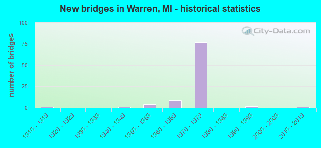
- New bridges - historical statistics
- 11910-1919
- 11940-1949
- 41950-1959
- 91960-1969
- 771970-1979
- 21990-1999
- 12010-2019
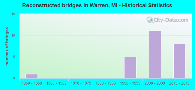
- Reconstructed bridges - Historical Statistics
- 11950-1959
- 01960-1969
- 01970-1979
- 01980-1989
- 51990-1999
- 112000-2009
- 82010-2019
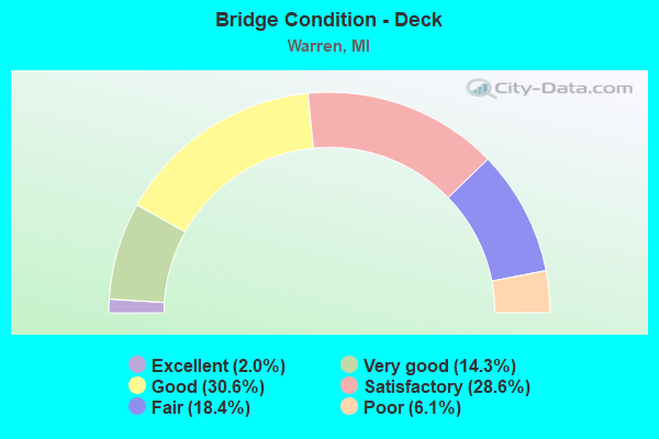
- Bridge Condition - Deck
- 2.0%Excellent
- 14.3%Very good
- 30.6%Good
- 28.6%Satisfactory
- 18.4%Fair
- 6.1%Poor
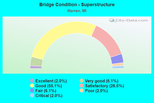
- Bridge Condition - Superstructure
- 2.0%Excellent
- 6.1%Very good
- 55.1%Good
- 26.5%Satisfactory
- 6.1%Fair
- 2.0%Poor
- 2.0%Critical
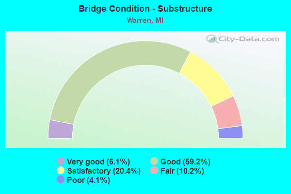
- Bridge Condition - Substructure
- 6.1%Very good
- 59.2%Good
- 20.4%Satisfactory
- 10.2%Fair
- 4.1%Poor
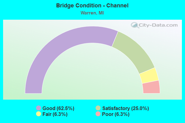
- Bridge Condition - Channel
- 62.5%Good
- 25.0%Satisfactory
- 6.3%Fair
- 6.3%Poor
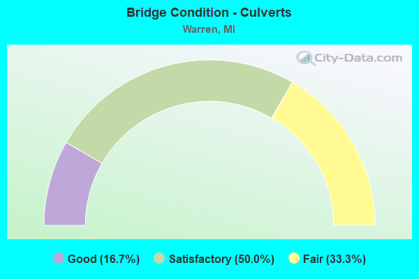
- Bridge Condition - Culverts
- 16.7%Good
- 50.0%Satisfactory
- 33.3%Fair
Find on map >> Show street view
Structure Number: 61, Location: 0.5 MI SOUTH OF DEERTON (Lat: 46.464350, Lng: -87.043211), Route carried "on" structure: County highway , Year Built: 1947, Status: Open, Structure Length: 0.61m (2.00ft), Average Daily Traffic: 73 (year 1995), Average Future Daily Traffic: 140 (year 2015), Features Intersected: LAUGHING WHITEFISH RIVER, Facility Carried by Structure: PETER WHITE ROAD
Minimum Vertical Clearance: 30.48m (100.00ft), Kilometerpoint: 1.069, Lanes on structure: 2, Owner: County Highway Agency, Approaching Roadway Width: 5.5m (18.0ft), Material/Design: Steel, Design/Construction: Stringer/Multi-beam, Number Of Spans In Main Unit: 1, Length of Maximum Span: 5.4m (17.7ft), Curb-To-Curb Width: 7.0m (23.0ft), Out-to-Out Width: 7.3m (24.0ft)
Condition: Deck: Satisfactory, Superstructure: Satisfactory, Substructure: Satisfactory, Channel: Good, Operating Rating: 32.7 metric tons, Method Used To Determine Operating Rating: Load Factor (LF), Inventory Rating: 23.6 metric tons, Method Used To Determine Inventory Rating: Load Factor (LF), Structural Evaluation: Equal to present minimum criteria, Deck Geometry: Somewhat better than minimum adequacy, Waterway Adequacy: Equal to present desirable criteria, Approach Roadway Alignment: Equal to present desirable criteria, Designated Inspection Frequency: Every 24 months, Inspection Date: September 2021, Deck Structure Type: Concrete Cast-file-Place, Wearing Surface/Protective System: Wearing Surface: Gravel
Find on map >> Show street view
Structure Number: 608, Location: 5.0 MI N OF KAWKAWLIN (Lat: 43.697875, Lng: -84.012850), Route carried "on" structure: Interstate 75, Year Built: 1968, Year Reconstructed: 2021, Status: Open, Structure Length: 4.11m (13.48ft), Average Daily Traffic: 11,638 (year 2021), Truck Traffic: 7%, Average Future Daily Traffic: 12,863 (year 2041), Design Load: HS 20, Features Intersected: N BR KAWKAWLIN RIVER
Minimum Vertical Clearance: 30.48m (100.00ft), Kilometerpoint: 21.680, Lanes on structure: 2, Base Highway Network: Yes (Inventory Route: 76, Subroute: 10), Owner: State Highway Agency, Approaching Roadway Width: 12.2m (40.0ft), Skew: 1 degrees, Material/Design: Steel continuous, Design/Construction: Stringer/Multi-beam, Number Of Spans In Main Unit: 3, Length of Maximum Span: 16.0m (52.5ft), Curb-To-Curb Width: 12.8m (42.0ft), Out-to-Out Width: 13.5m (44.3ft)
Condition: Deck: Excellent, Superstructure: Very good, Substructure: Good, Channel: Good, Operating Rating: 59.3 metric tons, Method Used To Determine Operating Rating: Load Factor (LF) rating reported by rating factor (RF) method using MS18 loading, Inventory Rating: 35.3 metric tons, Method Used To Determine Inventory Rating: Load Factor (LF) rating reported by rating factor (RF) method using MS18 loading, Structural Evaluation: Better than present minimum criteria, Deck Geometry: Equal to present desirable criteria, Waterway Adequacy: Equal to present desirable criteria, Approach Roadway Alignment: Equal to present minimum criteria, Designated Inspection Frequency: Every 18 months, Underwater Inspection Frequency: Every 60 months, Inspection Date: Febuary 2022, Underwater Inspection Date: September 2020, Deck Structure Type: Concrete Cast-file-Place, Wearing Surface/Protective System: Wearing Surface: Monolithic Concrete, Deck Protection: Other
Find on map >> Show street view
Structure Number: 609, Location: 4.0 MI SW OF PINCONNING (Lat: 43.844533, Lng: -84.020892), Route carried "on" structure: Interstate 75, Year Built: 2011, Status: Open, Structure Length: 1.98m (6.50ft), Average Daily Traffic: 15,522 (year 2007), Truck Traffic: 8%, Average Future Daily Traffic: 16,605 (year 2030), Design Load: HL 93, Features Intersected: PINCONNING RIVER
Minimum Vertical Clearance: 30.48m (100.00ft), Kilometerpoint: 38.122, Lanes on structure: 2, Base Highway Network: Yes (Inventory Route: 76, Subroute: 10), Owner: State Highway Agency, Approaching Roadway Width: 14.0m (45.9ft), Material/Design: Prestressed concrete, Design/Construction: Stringer/Multi-beam, Number Of Spans In Main Unit: 1, Length of Maximum Span: 19.1m (62.7ft), Curb-To-Curb Width: 14.0m (45.9ft), Out-to-Out Width: 14.9m (48.9ft)
Condition: Deck: Good, Superstructure: Excellent, Substructure: Very good, Channel: Satisfactory, Operating Rating: 77.8 metric tons, Method Used To Determine Operating Rating: Load and Resistance Factor Rating (LRFR) rating reported by rating factor(RF) method using HL-93 loadings, Inventory Rating: 45.4 metric tons, Method Used To Determine Inventory Rating: Load and Resistance Factor Rating (LRFR) rating reported by rating factor(RF) method using HL-93 loadings, Structural Evaluation: Equal to present desirable criteria, Deck Geometry: Superior to present desirable criteria, Waterway Adequacy: Equal to present desirable criteria, Approach Roadway Alignment: Equal to present desirable criteria, Designated Inspection Frequency: Every 24 months, Inspection Date: August 2021, Deck Structure Type: Concrete Cast-file-Place, Wearing Surface/Protective System: Wearing Surface: Monolithic Concrete, Deck Protection: Epoxy Coated Reinforcing
Find on map >> Show street view
Structure Number: 611, Location: 7.0 MI SW OF PINCONNING (Lat: 43.797344, Lng: -84.021547), Route carried "on" structure: Interstate 75, Year Built: 1968, Year Reconstructed: 2011, Status: Open, Structure Length: 0.73m (2.40ft), Average Daily Traffic: 15,522 (year 2007), Truck Traffic: 8%, Average Future Daily Traffic: 2,030 (year 2018), Design Load: Greater than HL93, Features Intersected: TEBO DRAIN
Minimum Vertical Clearance: 30.48m (100.00ft), Kilometerpoint: 32.878, Lanes on structure: 2, Base Highway Network: Yes (Inventory Route: 76, Subroute: 10), Owner: State Highway Agency, Approaching Roadway Width: 14.0m (45.9ft), Skew: 1 degrees, Material/Design: Prestressed concrete, Design/Construction: Stringer/Multi-beam, Number Of Spans In Main Unit: 1, Length of Maximum Span: 6.6m (21.7ft), Curb-To-Curb Width: 14.0m (45.9ft), Out-to-Out Width: 15.0m (49.2ft)
Condition: Deck: Good, Superstructure: Very good, Substructure: Good, Channel: Satisfactory, Operating Rating: 97.2 metric tons, Method Used To Determine Operating Rating: Load and Resistance Factor Rating (LRFR) rating reported by rating factor(RF) method using HL-93 loadings, Inventory Rating: 97.2 metric tons, Method Used To Determine Inventory Rating: Load and Resistance Factor Rating (LRFR) rating reported by rating factor(RF) method using HL-93 loadings, Structural Evaluation: Better than present minimum criteria, Deck Geometry: Superior to present desirable criteria, Waterway Adequacy: Better than present minimum criteria, Approach Roadway Alignment: Equal to present desirable criteria, Designated Inspection Frequency: Every 24 months, Inspection Date: August 2021, Deck Structure Type: Concrete Cast-file-Place, Wearing Surface/Protective System: Wearing Surface: Monolithic Concrete, Deck Protection: Epoxy Coated Reinforcing
Find on map >> Show street view
Structure Number: 624, Location: 1.5 MI W OF BAY CITY (Lat: 43.606017, Lng: -83.947719), Route carried "on" structure: Interstate 75, Year Built: 1960, Year Reconstructed: 2001, Status: Open, Structure Length: 4.23m (13.88ft), Average Daily Traffic: 18,568 (year 2007), Truck Traffic: 9%, Average Future Daily Traffic: 46,919 (year 2018), Design Load: HS 20+Mod, Features Intersected: GTW RR
Minimum Vertical Clearance: 30.48m (100.00ft), Kilometerpoint: 9.354, Lanes on structure: 3, Base Highway Network: Yes (Inventory Route: 76, Subroute: 1), Owner: State Highway Agency, Approaching Roadway Width: 17.4m (57.1ft), Skew: 10 degrees, Material/Design: Steel, Design/Construction: Stringer/Multi-beam, Number Of Spans In Main Unit: 3, Length of Maximum Span: 14.0m (45.9ft), Curb-To-Curb Width: 18.0m (59.1ft), Out-to-Out Width: 18.7m (61.4ft)
Condition: Deck: Fair, Superstructure: Satisfactory, Substructure: Fair, Operating Rating: 54.8 metric tons, Method Used To Determine Operating Rating: Load Factor (LF) rating reported by rating factor (RF) method using MS18 loading, Inventory Rating: 32.7 metric tons, Method Used To Determine Inventory Rating: Load Factor (LF) rating reported by rating factor (RF) method using MS18 loading, Structural Evaluation: Somewhat better than minimum adequacy, Deck Geometry: Better than present minimum criteria, Approach Roadway Alignment: Equal to present minimum criteria, Designated Inspection Frequency: Every 24 months, Inspection Date: September 2021, Deck Structure Type: Concrete Cast-file-Place, Wearing Surface/Protective System: Wearing Surface: Latex Concrete
Find on map >> Show street view
Structure Number: 3348, Location: 0.1 MILE N OF EGYPT ROAD (Lat: 41.828069, Lng: -84.380844), Route carried "on" structure: Alternate County highway , Year Built: 1910, Year Reconstructed: 1950, Status: Posted for load, Structure Length: 0.67m (2.20ft), Average Daily Traffic: 46 (year 2014), Average Future Daily Traffic: 75 (year 2038), Design Load: H 10, Features Intersected: MALLORY LAKE DRAIN, Facility Carried by Structure: ELM ROAD
Minimum Vertical Clearance: 30.48m (100.00ft), Kilometerpoint: 4.287, Lanes on structure: 2, Owner: County Highway Agency, Approaching Roadway Width: 5.8m (19.0ft), Material/Design: Steel, Design/Construction: Stringer/Multi-beam, Number Of Spans In Main Unit: 1, Length of Maximum Span: 6.1m (20.0ft), Curb-To-Curb Width: 6.1m (20.0ft), Out-to-Out Width: 6.1m (20.0ft)
Condition: Deck: Fair, Superstructure: Critical, Substructure: Poor, Channel: Fair, Operating Rating: 6.2 metric tons, Method Used To Determine Operating Rating: Load Factor (LF) rating reported by rating factor (RF) method using MS18 loading, Inventory Rating: 3.6 metric tons, Method Used To Determine Inventory Rating: Load Factor (LF) rating reported by rating factor (RF) method using MS18 loading, Structural Evaluation: High priority of replacement, Deck Geometry: Somewhat better than minimum adequacy, Waterway Adequacy: Equal to present desirable criteria, Approach Roadway Alignment: Somewhat better than minimum adequacy, Bridge Posting: Required (Relationship of Operating Rating to Maximum Legal Load: > 39.9% below), Length Of Structure Improvement: 0.91m (2.99ft), Designated Inspection Frequency: Every 12 months, Inspection Date: November 2021, Bridge Improvement Cost: $70,000, Total Project Cost: $100,000, Deck Structure Type: Wood or Timber, Wearing Surface/Protective System: Wearing Surface: Gravel
Find on map >> Show street view
Structure Number: 6004, Location: IN WARREN (Lat: 42.520194, Lng: -83.028867), Route carried "on" structure: State highway 53, Year Built: 1960, Status: Open, Structure Length: 0.85m (2.79ft), Average Daily Traffic: 50,187 (year 2007), Truck Traffic: 7%, Average Future Daily Traffic: 52,443 (year 2018), Design Load: HS 20, Features Intersected: BEAR CREEK
Minimum Vertical Clearance: 30.48m (100.00ft), Kilometerpoint: 8.015, Lanes on structure: 6, Base Highway Network: Yes (Inventory Route: 79, Subroute: 8), Owner: State Highway Agency, Approaching Roadway Width: 17.1m (56.1ft), Skew: 21 degrees, Material/Design: Concrete continuous, Design/Construction: Culvert, Number Of Spans In Main Unit: 2, Length of Maximum Span: 4.2m (13.8ft), Curb-To-Curb Width: 13.4m (44.0ft), Out-to-Out Width: 44.2m (145.0ft)
Condition: Channel: Satisfactory, Culverts: Satisfactory, Operating Rating: 62.9 metric tons, Method Used To Determine Operating Rating: Load Factor (LF) rating reported by rating factor (RF) method using MS18 loading, Inventory Rating: 37.6 metric tons, Method Used To Determine Inventory Rating: Load Factor (LF) rating reported by rating factor (RF) method using MS18 loading, Structural Evaluation: Equal to present minimum criteria, Deck Geometry: High priority of replacement, Waterway Adequacy: Better than present minimum criteria, Approach Roadway Alignment: Equal to present desirable criteria, Designated Inspection Frequency: Every 24 months, Inspection Date: March 2020, Deck Structure Type: Concrete Cast-file-Place, Wearing Surface/Protective System: Wearing Surface: Bituminous
Find on map >> Show street view
Structure Number: 6005, Location: IN WARREN (Lat: 42.525522, Lng: -83.029056), Route carried "on" structure: State highway 53, Year Built: 1964, Year Reconstructed: 1995, Status: Open, Structure Length: 3.29m (10.79ft), Average Daily Traffic: 55,558 (year 2007), Truck Traffic: 5%, Average Future Daily Traffic: 66,976 (year 2018), Design Load: HS 25 or greater, Features Intersected: RED RUN DRAIN
Minimum Vertical Clearance: 30.48m (100.00ft), Kilometerpoint: 8.605, Lanes on structure: 7, Base Highway Network: Yes (Inventory Route: 79, Subroute: 8), Owner: State Highway Agency, Approaching Roadway Width: 30.2m (99.1ft), Material/Design: Prestressed concrete, Design/Construction: Stringer/Multi-beam, Number Of Spans In Main Unit: 3, Length of Maximum Span: 12.5m (41.0ft), Curb or Sidewalk Widths: Left: 1.5m (4.9ft), Right: 1.5m (4.9ft), Curb-To-Curb Width: 31.7m (104.0ft), Out-to-Out Width: 36.2m (118.8ft)
Condition: Deck: Good, Superstructure: Satisfactory, Substructure: Satisfactory, Channel: Good, Operating Rating: 68.0 metric tons, Method Used To Determine Operating Rating: Load Factor (LF) rating reported by rating factor (RF) method using MS18 loading, Inventory Rating: 40.8 metric tons, Method Used To Determine Inventory Rating: Load Factor (LF) rating reported by rating factor (RF) method using MS18 loading, Structural Evaluation: Equal to present minimum criteria, Deck Geometry: Superior to present desirable criteria, Waterway Adequacy: Somewhat better than minimum adequacy, Approach Roadway Alignment: Equal to present desirable criteria, Designated Inspection Frequency: Every 24 months, Inspection Date: March 2020, Deck Structure Type: Concrete Cast-file-Place, Wearing Surface/Protective System: Wearing Surface: Monolithic Concrete, Deck Protection: Epoxy Coated Reinforcing
Find on map >> Show street view
Structure Number: 6006, Location: IN WARREN (Lat: 42.532850, Lng: -83.029256), Route carried "on" structure: State highway 53, Year Built: 1964, Year Reconstructed: 1998, Status: Open, Structure Length: 1.92m (6.30ft), Average Daily Traffic: 55,558 (year 2007), Truck Traffic: 5%, Average Future Daily Traffic: 66,976 (year 2018), Design Load: HS 25 or greater, Features Intersected: BEAVER CREEK
Minimum Vertical Clearance: 30.48m (100.00ft), Kilometerpoint: 9.420, Lanes on structure: 6, Base Highway Network: Yes (Inventory Route: 79, Subroute: 8), Owner: State Highway Agency, Approaching Roadway Width: 26.5m (86.9ft), Skew: 2 degrees, Material/Design: Prestressed concrete, Design/Construction: Box Beam or Girders - Single/Spread, Number Of Spans In Main Unit: 1, Length of Maximum Span: 19.2m (63.0ft), Curb or Sidewalk Widths: Left: 1.5m (4.9ft), Right: 1.5m (4.9ft), Curb-To-Curb Width: 26.5m (86.9ft), Out-to-Out Width: 30.1m (98.8ft)
Condition: Deck: Good, Superstructure: Good, Substructure: Good, Channel: Good, Operating Rating: 55.4 metric tons, Method Used To Determine Operating Rating: Load Factor (LF), Inventory Rating: 33.2 metric tons, Method Used To Determine Inventory Rating: Load Factor (LF), Structural Evaluation: Better than present minimum criteria, Deck Geometry: Equal to present minimum criteria, Waterway Adequacy: Better than present minimum criteria, Approach Roadway Alignment: Better than present minimum criteria, Designated Inspection Frequency: Every 24 months, Inspection Date: March 2020, Deck Structure Type: Concrete Cast-file-Place, Wearing Surface/Protective System: Wearing Surface: Monolithic Concrete, Deck Protection: Epoxy Coated Reinforcing
Find on map >> Show street view
Structure Number: 6074, Location: 0.1 MI E OF DEQUINDRE (Lat: 42.485556, Lng: -83.083517), Route carried "on" structure: City street , Year Built: 1972, Year Reconstructed: 2002, Status: Open, Structure Length: 5.24m (17.19ft), Average Daily Traffic: 147,000 (year 1993), Average Future Daily Traffic: 4,800 (year 2000), Design Load: HS 20+Mod, Features Intersected: I-696, Facility Carried by Structure: U TURN @ AUGUSTINE
Minimum Vertical Clearance: 30.48m (100.00ft), Kilometerpoint: 0.035, Lanes on structure: 2, Lanes under structure: 8, Owner: State Highway Agency, Approaching Roadway Width: 9.1m (29.9ft), Material/Design: Steel, Design/Construction: Stringer/Multi-beam, Number Of Spans In Main Unit: 2, Length of Maximum Span: 26.2m (86.0ft), Curb-To-Curb Width: 7.1m (23.3ft), Out-to-Out Width: 7.8m (25.6ft)
Condition: Deck: Good, Superstructure: Good, Substructure: Satisfactory, Operating Rating: 76.5 metric tons, Method Used To Determine Operating Rating: Load Factor (LF), Inventory Rating: 45.9 metric tons, Method Used To Determine Inventory Rating: Load Factor (LF), Structural Evaluation: Equal to present minimum criteria, Deck Geometry: High priority of replacement, Underclear: Somewhat better than minimum adequacy, Approach Roadway Alignment: Equal to present desirable criteria, Designated Inspection Frequency: Every 24 months, Inspection Date: March 2021, Deck Structure Type: Concrete Cast-file-Place, Wearing Surface/Protective System: Wearing Surface: Monolithic Concrete, Deck Protection: Epoxy Coated Reinforcing
Find on map >> Show street view
Structure Number: 6075, Location: IN WARREN (Lat: 42.490133, Lng: -83.079106), Route carried "on" structure: Ramp Interstate 696, Year Built: 1972, Status: Open, Structure Length: 7.98m (26.18ft), Average Daily Traffic: 4,000 (year 2007), Truck Traffic: 3%, Average Future Daily Traffic: 4,400 (year 2022), Design Load: H 20, Features Intersected: I-696
Minimum Vertical Clearance: 30.48m (100.00ft), Kilometerpoint: 0.507, Lanes on structure: 2, Lanes under structure: 8, Owner: State Highway Agency, Approaching Roadway Width: 8.8m (28.9ft), Skew: 4 degrees, Material/Design: Steel continuous, Design/Construction: Stringer/Multi-beam, Number Of Spans In Main Unit: 2, Length of Maximum Span: 45.4m (149.0ft), Curb or Sidewalk Widths: Left: 0.6m (2.0ft), Right: 2.2m (7.2ft), Curb-To-Curb Width: 8.7m (28.5ft), Out-to-Out Width: 11.6m (38.1ft)
Condition: Deck: Satisfactory, Superstructure: Poor, Substructure: Good, Operating Rating: 77.8 metric tons, Method Used To Determine Operating Rating: Load Factor (LF) rating reported by rating factor (RF) method using MS18 loading, Inventory Rating: 46.7 metric tons, Method Used To Determine Inventory Rating: Load Factor (LF) rating reported by rating factor (RF) method using MS18 loading, Structural Evaluation: Meets minimum limits, Deck Geometry: Meets minimum limits, Underclear: Equal to present minimum criteria, Approach Roadway Alignment: Equal to present minimum criteria, Length Of Structure Improvement: 7.99m (26.21ft), Designated Inspection Frequency: Every 24 months, Inspection Date: March 2021, Bridge Improvement Cost: $229,000, Roadway Improvement Cost: $12,000, Total Project Cost: $139,000, Deck Structure Type: Concrete Cast-file-Place, Wearing Surface/Protective System: Wearing Surface: Monolithic Concrete
Find on map >> Show street view
Structure Number: 6076, Location: IN WARREN (Lat: 42.491036, Lng: -83.066928), Route carried "on" structure: City street 2058, Year Built: 1972, Status: Open, Structure Length: 5.43m (17.81ft), Average Daily Traffic: 28,800 (year 1994), Truck Traffic: 3%, Average Future Daily Traffic: 32,000 (year 2009), Design Load: H 20, Features Intersected: I-696, Facility Carried by Structure: RYAN ST
Minimum Vertical Clearance: 30.48m (100.00ft), Kilometerpoint: 4.873, Lanes on structure: 4, Lanes under structure: 10, Owner: State Highway Agency, Approaching Roadway Width: 20.1m (65.9ft), Material/Design: Steel, Design/Construction: Stringer/Multi-beam, Number Of Spans In Main Unit: 2, Length of Maximum Span: 27.1m (88.9ft), Curb or Sidewalk Widths: Left: 2.2m (7.2ft), Right: 1.8m (5.9ft), Curb-To-Curb Width: 19.5m (64.0ft), Out-to-Out Width: 23.9m (78.4ft)
Condition: Deck: Satisfactory, Superstructure: Good, Substructure: Good, Operating Rating: 76.1 metric tons, Method Used To Determine Operating Rating: Load Factor (LF) rating reported by rating factor (RF) method using MS18 loading, Inventory Rating: 50.2 metric tons, Method Used To Determine Inventory Rating: Load Factor (LF) rating reported by rating factor (RF) method using MS18 loading, Structural Evaluation: Better than present minimum criteria, Deck Geometry: Better than present minimum criteria, Underclear: Equal to present minimum criteria, Approach Roadway Alignment: Equal to present desirable criteria, Length Of Structure Improvement: 5.43m (17.81ft), Designated Inspection Frequency: Every 24 months, Inspection Date: March 2021, Bridge Improvement Cost: $172,000, Roadway Improvement Cost: $10,000, Total Project Cost: $116,000, Deck Structure Type: Concrete Cast-file-Place, Wearing Surface/Protective System: Wearing Surface: Epoxy Overlay
Find on map >> Show street view
Structure Number: 6077, Location: IN WARREN (Lat: 42.491408, Lng: -83.059222), Route carried "on" structure: City street , Year Built: 1972, Status: Open, Structure Length: 5.72m (18.77ft), Average Daily Traffic: 2,500 (year 2007), Truck Traffic: 3%, Average Future Daily Traffic: 2,750 (year 2022), Design Load: H 20, Features Intersected: I-696, Facility Carried by Structure: MEREDITH DR
Minimum Vertical Clearance: 30.48m (100.00ft), Kilometerpoint: 0.311, Lanes on structure: 2, Lanes under structure: 10, Owner: State Highway Agency, Approaching Roadway Width: 10.9m (35.8ft), Skew: 1 degrees, Material/Design: Steel, Design/Construction: Stringer/Multi-beam, Number Of Spans In Main Unit: 2, Length of Maximum Span: 28.6m (93.8ft), Curb or Sidewalk Widths: Left: 1.8m (5.9ft), Right: 1.8m (5.9ft), Curb-To-Curb Width: 12.2m (40.0ft), Out-to-Out Width: 16.6m (54.5ft)
Condition: Deck: Poor, Superstructure: Good, Substructure: Good, Operating Rating: 60.0 metric tons, Method Used To Determine Operating Rating: Load Factor (LF), Inventory Rating: 36.0 metric tons, Method Used To Determine Inventory Rating: Load Factor (LF), Structural Evaluation: Better than present minimum criteria, Deck Geometry: Equal to present minimum criteria, Underclear: Somewhat better than minimum adequacy, Approach Roadway Alignment: Equal to present desirable criteria, Length Of Structure Improvement: 5.73m (18.80ft), Designated Inspection Frequency: Every 24 months, Inspection Date: March 2021, Bridge Improvement Cost: $145,000, Roadway Improvement Cost: $8,000, Total Project Cost: $97,000, Deck Structure Type: Concrete Cast-file-Place, Wearing Surface/Protective System: Wearing Surface: Epoxy Overlay
Find on map >> Show street view
Structure Number: 6078, Location: @ CRYSTAL IN WARREN (Lat: 42.490881, Lng: -83.055444), Route carried "on" structure: City street , Year Built: 1972, Status: Open, Structure Length: 10.22m (33.53ft), Average Daily Traffic: 4,000 (year 2007), Truck Traffic: 3%, Average Future Daily Traffic: 4,400 (year 2022), Design Load: H 20, Features Intersected: I-696, Facility Carried by Structure: EB 11 MILE RD
Minimum Vertical Clearance: 30.48m (100.00ft), Kilometerpoint: 2.813, Lanes on structure: 2, Lanes under structure: 10, Owner: State Highway Agency, Approaching Roadway Width: 7.9m (25.9ft), Skew: 5 degrees, Material/Design: Steel, Design/Construction: Stringer/Multi-beam, Number Of Spans In Main Unit: 2, Length of Maximum Span: 52.9m (173.6ft), Curb or Sidewalk Widths: Left: 0.0m, Right: 1.8m (5.9ft), Curb-To-Curb Width: 8.7m (28.5ft), Out-to-Out Width: 13.6m (44.6ft)
Condition: Deck: Poor, Superstructure: Good, Substructure: Fair, Operating Rating: 83.2 metric tons, Method Used To Determine Operating Rating: Load Factor (LF), Inventory Rating: 49.9 metric tons, Method Used To Determine Inventory Rating: Load Factor (LF), Structural Evaluation: Somewhat better than minimum adequacy, Deck Geometry: Meets minimum limits, Underclear: Somewhat better than minimum adequacy, Approach Roadway Alignment: Equal to present desirable criteria, Length Of Structure Improvement: 10.21m (33.50ft), Designated Inspection Frequency: Every 24 months, Inspection Date: March 2021, Bridge Improvement Cost: $353,000, Roadway Improvement Cost: $20,000, Total Project Cost: $233,000, Deck Structure Type: Concrete Cast-file-Place, Wearing Surface/Protective System: Wearing Surface: Epoxy Overlay
Find on map >> Show street view
Structure Number: 6079, Location: CITY OF WARREN (Lat: 42.486939, Lng: -83.043986), Route carried "on" structure: Ramp Interstate 696, Year Built: 1975, Status: Open, Structure Length: 46.76m (153.41ft), Average Daily Traffic: 11,400 (year 1988), Truck Traffic: 8%, Average Future Daily Traffic: 13,110 (year 2008), Design Load: HS 25 or greater, Features Intersected: I-696, Facility Carried by Structure: RAMP H AT MOUND RD
Minimum Vertical Clearance: 30.48m (100.00ft), Kilometerpoint: 0.361, Lanes on structure: 2, Lanes under structure: 26, Owner: State Highway Agency, Approaching Roadway Width: 13.1m (43.0ft), Material/Design: Steel continuous, Design/Construction: Stringer/Multi-beam, Number Of Spans In Main Unit: 15, Length of Maximum Span: 36.5m (119.8ft), Curb-To-Curb Width: 13.0m (42.7ft), Out-to-Out Width: 13.5m (44.3ft)
Condition: Deck: Fair, Superstructure: Good, Substructure: Good, Operating Rating: 81.0 metric tons, Method Used To Determine Operating Rating: Load Factor (LF) rating reported by rating factor (RF) method using MS18 loading, Inventory Rating: 48.6 metric tons, Method Used To Determine Inventory Rating: Load Factor (LF) rating reported by rating factor (RF) method using MS18 loading, Structural Evaluation: Better than present minimum criteria, Deck Geometry: Superior to present desirable criteria, Underclear: Somewhat better than minimum adequacy, Approach Roadway Alignment: Equal to present desirable criteria, Length Of Structure Improvement: 46.77m (153.44ft), Designated Inspection Frequency: Every 24 months, Inspection Date: April 2021, Bridge Improvement Cost: $176,000, Roadway Improvement Cost: $54,000, Total Project Cost: $638,000, Deck Structure Type: Concrete Cast-file-Place, Wearing Surface/Protective System: Wearing Surface: Monolithic Concrete
Find on map >> Show street view
Structure Number: 608, Location: CITY OF WARREN (Lat: 42.487906, Lng: -83.043744), Route carried "on" structure: Ramp Interstate 696, Year Built: 1975, Status: Open, Structure Length: 41.00m (134.51ft), Average Daily Traffic: 11,400 (year 1988), Truck Traffic: 8%, Average Future Daily Traffic: 10,230 (year 1977), Design Load: HS 25 or greater, Features Intersected: I-696, Facility Carried by Structure: RAMP G AT MOUND RD
Minimum Vertical Clearance: 30.48m (100.00ft), Kilometerpoint: 0.293, Lanes on structure: 2, Lanes under structure: 22, Owner: State Highway Agency, Approaching Roadway Width: 13.1m (43.0ft), Material/Design: Steel continuous, Design/Construction: Stringer/Multi-beam, Number Of Spans In Main Unit: 15, Length of Maximum Span: 35.9m (117.8ft), Curb-To-Curb Width: 12.5m (41.0ft), Out-to-Out Width: 13.6m (44.6ft)
Condition: Deck: Fair, Superstructure: Good, Substructure: Good, Operating Rating: 72.3 metric tons, Method Used To Determine Operating Rating: Load Factor (LF) rating reported by rating factor (RF) method using MS18 loading, Inventory Rating: 43.4 metric tons, Method Used To Determine Inventory Rating: Load Factor (LF) rating reported by rating factor (RF) method using MS18 loading, Structural Evaluation: Better than present minimum criteria, Deck Geometry: Superior to present desirable criteria, Underclear: Equal to present minimum criteria, Approach Roadway Alignment: Equal to present desirable criteria, Length Of Structure Improvement: 41.01m (134.55ft), Designated Inspection Frequency: Every 24 months, Inspection Date: April 2021, Bridge Improvement Cost: $144,000, Roadway Improvement Cost: $48,000, Total Project Cost: $561,000, Deck Structure Type: Concrete Cast-file-Place, Wearing Surface/Protective System: Wearing Surface: Monolithic Concrete
Find on map >> Show street view
Structure Number: 6081, Location: CITY OF WARREN (Lat: 42.484286, Lng: -83.044997), Route carried "on" structure: City street , Year Built: 1977, Status: Open, Structure Length: 12.96m (42.52ft), Average Daily Traffic: 11,996 (year 2007), Truck Traffic: 3%, Average Future Daily Traffic: 13,196 (year 2022), Design Load: H 20, Features Intersected: MND RD &RMPS A&B O I-696, Facility Carried by Structure: 10.5 MI ROAD
Minimum Vertical Clearance: 30.48m (100.00ft), Kilometerpoint: 1.783, Lanes on structure: 2, Lanes under structure: 11, Owner: State Highway Agency, Approaching Roadway Width: 9.1m (29.9ft), Material/Design: Steel, Design/Construction: Stringer/Multi-beam, Number Of Spans In Main Unit: 5, Length of Maximum Span: 33.4m (109.6ft), Curb or Sidewalk Widths: Left: 2.2m (7.2ft), Right: 2.2m (7.2ft), Curb-To-Curb Width: 9.8m (32.2ft), Out-to-Out Width: 14.1m (46.3ft)
Condition: Deck: Fair, Superstructure: Good, Substructure: Fair, Operating Rating: 77.8 metric tons, Method Used To Determine Operating Rating: Load Factor (LF) rating reported by rating factor (RF) method using MS18 loading, Inventory Rating: 46.3 metric tons, Method Used To Determine Inventory Rating: Load Factor (LF) rating reported by rating factor (RF) method using MS18 loading, Structural Evaluation: Somewhat better than minimum adequacy, Deck Geometry: Meets minimum limits, Underclear: Somewhat better than minimum adequacy, Approach Roadway Alignment: Better than present minimum criteria, Length Of Structure Improvement: 12.96m (42.52ft), Designated Inspection Frequency: Every 24 months, Inspection Date: April 2021, Bridge Improvement Cost: $200,000, Roadway Improvement Cost: $11,000, Total Project Cost: $133,000, Deck Structure Type: Concrete Cast-file-Place, Wearing Surface/Protective System: Wearing Surface: Monolithic Concrete
Find on map >> Show street view
Structure Number: 6082, Location: CITY OF WARREN (Lat: 42.491206, Lng: -83.045211), Route carried "on" structure: City street 2058, Year Built: 1977, Status: Open, Structure Length: 11.88m (38.98ft), Average Daily Traffic: 9,800 (year 0000), Truck Traffic: 3%, Average Future Daily Traffic: 9,800 (year 2015), Design Load: HS 20, Features Intersected: MND RD &RMPS O I-696, Facility Carried by Structure: 11 MI RD EB
Minimum Vertical Clearance: 30.48m (100.00ft), Kilometerpoint: 3.694, Lanes on structure: 3, Lanes under structure: 8, Owner: State Highway Agency, Approaching Roadway Width: 12.2m (40.0ft), Skew: 10 degrees, Material/Design: Steel, Design/Construction: Stringer/Multi-beam, Number Of Spans In Main Unit: 4, Length of Maximum Span: 47.4m (155.5ft), Curb or Sidewalk Widths: Left: 0.6m (2.0ft), Right: 1.8m (5.9ft), Curb-To-Curb Width: 12.5m (41.0ft), Out-to-Out Width: 15.2m (49.9ft)
Condition: Deck: Satisfactory, Superstructure: Satisfactory, Substructure: Satisfactory, Operating Rating: 66.1 metric tons, Method Used To Determine Operating Rating: Load Factor (LF), Inventory Rating: 39.7 metric tons, Method Used To Determine Inventory Rating: Load Factor (LF), Structural Evaluation: Equal to present minimum criteria, Deck Geometry: Meets minimum limits, Underclear: Better than present minimum criteria, Approach Roadway Alignment: Equal to present desirable criteria, Length Of Structure Improvement: 11.89m (39.01ft), Designated Inspection Frequency: Every 24 months, Inspection Date: April 2021, Bridge Improvement Cost: $361,000, Roadway Improvement Cost: $16,000, Total Project Cost: $193,000, Deck Structure Type: Concrete Cast-file-Place, Wearing Surface/Protective System: Wearing Surface: Monolithic Concrete
Find on map >> Show street view
Structure Number: 6083, Location: CITY OF WARREN (Lat: 42.491589, Lng: -83.045253), Route carried "on" structure: City street 2058, Year Built: 1977, Status: Open, Structure Length: 10.94m (35.89ft), Average Daily Traffic: 6,098 (year 2010), Average Future Daily Traffic: 6,708 (year 2025), Design Load: HS 20, Features Intersected: MND RD &RMPS C&D O I-696, Facility Carried by Structure: 11 MI RD WB
Minimum Vertical Clearance: 30.48m (100.00ft), Kilometerpoint: 3.642, Lanes on structure: 4, Lanes under structure: 8, Owner: State Highway Agency, Approaching Roadway Width: 12.2m (40.0ft), Skew: 10 degrees, Material/Design: Steel, Design/Construction: Stringer/Multi-beam, Number Of Spans In Main Unit: 4, Length of Maximum Span: 41.4m (135.8ft), Curb or Sidewalk Widths: Left: 0.6m (2.0ft), Right: 0.6m (2.0ft), Curb-To-Curb Width: 17.9m (58.7ft), Out-to-Out Width: 22.2m (72.8ft)
Condition: Deck: Satisfactory, Superstructure: Good, Substructure: Good, Operating Rating: 57.8 metric tons, Method Used To Determine Operating Rating: Load Factor (LF), Inventory Rating: 34.7 metric tons, Method Used To Determine Inventory Rating: Load Factor (LF), Structural Evaluation: Better than present minimum criteria, Deck Geometry: Somewhat better than minimum adequacy, Underclear: Equal to present minimum criteria, Approach Roadway Alignment: Better than present minimum criteria, Length Of Structure Improvement: 10.95m (35.93ft), Designated Inspection Frequency: Every 24 months, Inspection Date: April 2021, Bridge Improvement Cost: $489,000, Roadway Improvement Cost: $22,000, Total Project Cost: $261,000, Deck Structure Type: Concrete Cast-file-Place, Wearing Surface/Protective System: Wearing Surface: Monolithic Concrete
Find on map >> Show street view
Structure Number: 6084, Location: CITY OF WARREN (Lat: 42.487850, Lng: -83.041669), Route carried "on" structure: City street 2058, Year Built: 1975, Year Reconstructed: 2008, Status: Open, Structure Length: 17.97m (58.96ft), Average Daily Traffic: 12,000 (year 1977), Truck Traffic: 3%, Average Future Daily Traffic: 12,000 (year 1977), Design Load: H 20, Features Intersected: I-696 &RAMPS B,C,H,&F, Facility Carried by Structure: SHERWOOD AVE
Minimum Vertical Clearance: 30.48m (100.00ft), Kilometerpoint: 4.595, Lanes on structure: 4, Lanes under structure: 13, Owner: State Highway Agency, Approaching Roadway Width: 18.9m (62.0ft), Skew: 3 degrees, Material/Design: Steel, Design/Construction: Stringer/Multi-beam, Number Of Spans In Main Unit: 6, Length of Maximum Span: 43.7m (143.4ft), Curb or Sidewalk Widths: Left: 1.8m (5.9ft), Right: 1.8m (5.9ft), Curb-To-Curb Width: 15.8m (51.8ft), Out-to-Out Width: 20.2m (66.3ft)
Condition: Deck: Good, Superstructure: Good, Substructure: Good, Operating Rating: 49.2 metric tons, Method Used To Determine Operating Rating: Load Factor (LF) rating reported by rating factor (RF) method using MS18 loading, Inventory Rating: 32.4 metric tons, Method Used To Determine Inventory Rating: Load Factor (LF) rating reported by rating factor (RF) method using MS18 loading, Structural Evaluation: Better than present minimum criteria, Deck Geometry: Meets minimum limits, Underclear: Somewhat better than minimum adequacy, Approach Roadway Alignment: Equal to present desirable criteria, Length Of Structure Improvement: 17.38m (57.02ft), Designated Inspection Frequency: Every 24 months, Inspection Date: April 2021, Bridge Improvement Cost: $530,000, Roadway Improvement Cost: $30,000, Total Project Cost: $350,000, Deck Structure Type: Concrete Cast-file-Place, Wearing Surface/Protective System: Wearing Surface: Monolithic Concrete, Deck Protection: Epoxy Coated Reinforcing
Find on map >> Show street view
Structure Number: 6085, Location: IN CENTERLINE (Lat: 42.491142, Lng: -83.036042), Route carried "on" structure: City street , Year Built: 1972, Status: Open, Structure Length: 10.27m (33.69ft), Average Daily Traffic: 9,800 (year 2007), Truck Traffic: 3%, Average Future Daily Traffic: 10,780 (year 2022), Design Load: H 20, Features Intersected: I-696, Facility Carried by Structure: EB 11 MILE RD
Minimum Vertical Clearance: 30.48m (100.00ft), Kilometerpoint: 4.450, Lanes on structure: 2, Lanes under structure: 10, Owner: State Highway Agency, Approaching Roadway Width: 7.9m (25.9ft), Skew: 5 degrees, Material/Design: Steel, Design/Construction: Stringer/Multi-beam, Number Of Spans In Main Unit: 2, Length of Maximum Span: 55.2m (181.1ft), Curb or Sidewalk Widths: Left: 0.6m (2.0ft), Right: 2.2m (7.2ft), Curb-To-Curb Width: 8.7m (28.5ft), Out-to-Out Width: 11.6m (38.1ft)
Condition: Deck: Fair, Superstructure: Good, Substructure: Good, Operating Rating: 78.4 metric tons, Method Used To Determine Operating Rating: Load Factor (LF) rating reported by rating factor (RF) method using MS18 loading, Inventory Rating: 47.0 metric tons, Method Used To Determine Inventory Rating: Load Factor (LF) rating reported by rating factor (RF) method using MS18 loading, Structural Evaluation: Better than present minimum criteria, Deck Geometry: Meets minimum limits, Underclear: Meets minimum limits, Approach Roadway Alignment: Equal to present desirable criteria, Length Of Structure Improvement: 10.27m (33.69ft), Designated Inspection Frequency: Every 24 months, Inspection Date: September 2021, Bridge Improvement Cost: $352,000, Roadway Improvement Cost: $20,000, Total Project Cost: $233,000, Deck Structure Type: Concrete Cast-file-Place, Wearing Surface/Protective System: Wearing Surface: Epoxy Overlay
Find on map >> Show street view
Structure Number: 6086, Location: IN WARREN & CENTERLINE (Lat: 42.491556, Lng: -83.029239), Route carried "on" structure: Ramp City street , Year Built: 1972, Year Reconstructed: 2010, Status: Open, Structure Length: 5.97m (19.59ft), Average Daily Traffic: 5,500 (year 1988), Truck Traffic: 3%, Average Future Daily Traffic: 6,720 (year 2031), Design Load: HS 20, Features Intersected: I-696, Facility Carried by Structure: U-TRN & LFT TRN
Minimum Vertical Clearance: 30.48m (100.00ft), Kilometerpoint: 0.045, Lanes on structure: 3, Lanes under structure: 8, Owner: State Highway Agency, Approaching Roadway Width: 16.8m (55.1ft), Skew: 30 degrees, Material/Design: Steel continuous, Design/Construction: Stringer/Multi-beam, Number Of Spans In Main Unit: 2, Length of Maximum Span: 29.1m (95.5ft), Curb-To-Curb Width: 16.9m (55.4ft), Out-to-Out Width: 20.1m (65.9ft)
Condition: Deck: Very good, Superstructure: Good, Substructure: Good, Operating Rating: 72.9 metric tons, Method Used To Determine Operating Rating: Load Factor (LF) rating reported by rating factor (RF) method using MS18 loading, Inventory Rating: 43.4 metric tons, Method Used To Determine Inventory Rating: Load Factor (LF) rating reported by rating factor (RF) method using MS18 loading, Structural Evaluation: Better than present minimum criteria, Deck Geometry: Superior to present desirable criteria, Underclear: Equal to present minimum criteria, Approach Roadway Alignment: Equal to present desirable criteria, Designated Inspection Frequency: Every 24 months, Inspection Date: September 2021, Deck Structure Type: Concrete Cast-file-Place, Wearing Surface/Protective System: Wearing Surface: Monolithic Concrete, Deck Protection: Epoxy Coated Reinforcing
Find on map >> Show street view
Structure Number: 6087, Location: IN WARREN & CENTERLINE (Lat: 42.491583, Lng: -83.027778), Route carried "on" structure: State highway 53, Year Built: 1972, Year Reconstructed: 2010, Status: Open, Structure Length: 6.31m (20.70ft), Average Daily Traffic: 28,327 (year 2007), Truck Traffic: 6%, Average Future Daily Traffic: 67,400 (year 2031), Design Load: HS 20, Features Intersected: I-696
Minimum Vertical Clearance: 30.48m (100.00ft), Kilometerpoint: 4.835, Lanes on structure: 7, Lanes under structure: 8, Base Highway Network: Yes (Inventory Route: 79, Subroute: 8), Owner: State Highway Agency, Approaching Roadway Width: 26.9m (88.3ft), Material/Design: Steel continuous, Design/Construction: Stringer/Multi-beam, Number Of Spans In Main Unit: 2, Length of Maximum Span: 30.8m (101.0ft), Curb or Sidewalk Widths: Left: 2.9m (9.5ft), Right: 2.9m (9.5ft), Curb-To-Curb Width: 26.8m (87.9ft), Out-to-Out Width: 32.4m (106.3ft)
Condition: Deck: Good, Superstructure: Fair, Substructure: Very good, Operating Rating: 81.8 metric tons, Method Used To Determine Operating Rating: Load Factor (LF), Inventory Rating: 49.0 metric tons, Method Used To Determine Inventory Rating: Load Factor (LF), Structural Evaluation: Somewhat better than minimum adequacy, Deck Geometry: Somewhat better than minimum adequacy, Underclear: Equal to present minimum criteria, Approach Roadway Alignment: Equal to present desirable criteria, Designated Inspection Frequency: Every 24 months, Inspection Date: September 2021, Deck Structure Type: Concrete Cast-file-Place, Wearing Surface/Protective System: Wearing Surface: Monolithic Concrete, Deck Protection: Epoxy Coated Reinforcing
Find on map >> Show street view
Structure Number: 6088, Location: IN WARREN & CENTERLINE (Lat: 42.491633, Lng: -83.026431), Route carried "on" structure: Ramp City street , Year Built: 1972, Year Reconstructed: 2007, Status: Open, Structure Length: 5.97m (19.59ft), Average Daily Traffic: 5,500 (year 1988), Truck Traffic: 3%, Average Future Daily Traffic: 6,325 (year 2008), Design Load: HS 20, Features Intersected: I-696, Facility Carried by Structure: LFT TRN LANE
Minimum Vertical Clearance: 30.48m (100.00ft), Kilometerpoint: 0.047, Lanes on structure: 2, Lanes under structure: 8, Owner: State Highway Agency, Approaching Roadway Width: 8.5m (27.9ft), Material/Design: Steel continuous, Design/Construction: Stringer/Multi-beam, Number Of Spans In Main Unit: 2, Length of Maximum Span: 29.9m (98.1ft), Curb-To-Curb Width: 12.8m (42.0ft), Out-to-Out Width: 13.7m (44.9ft)
Condition: Deck: Fair, Superstructure: Good, Substructure: Good, Operating Rating: 73.2 metric tons, Method Used To Determine Operating Rating: Load Factor (LF), Inventory Rating: 43.8 metric tons, Method Used To Determine Inventory Rating: Load Factor (LF), Structural Evaluation: Better than present minimum criteria, Deck Geometry: Superior to present desirable criteria, Underclear: Equal to present minimum criteria, Approach Roadway Alignment: Equal to present desirable criteria, Designated Inspection Frequency: Every 24 months, Inspection Date: September 2021, Deck Structure Type: Concrete Cast-file-Place, Wearing Surface/Protective System: Wearing Surface: Latex Concrete, Deck Protection: Epoxy Coated Reinforcing
Find on map >> Show street view
Structure Number: 6089, Location: IN WARREN W OF HOOVER (Lat: 42.491933, Lng: -83.008233), Route carried "on" structure: Ramp City street , Year Built: 1972, Year Reconstructed: 2010, Status: Open, Structure Length: 5.97m (19.59ft), Average Daily Traffic: 3,500 (year 1988), Truck Traffic: 3%, Average Future Daily Traffic: 3,200 (year 2031), Design Load: H 20, Features Intersected: I-696, Facility Carried by Structure: LFT TRN LANE
Minimum Vertical Clearance: 30.48m (100.00ft), Kilometerpoint: 0.064, Lanes on structure: 2, Lanes under structure: 8, Owner: State Highway Agency, Approaching Roadway Width: 9.1m (29.9ft), Material/Design: Steel continuous, Design/Construction: Stringer/Multi-beam, Number Of Spans In Main Unit: 2, Length of Maximum Span: 29.1m (95.5ft), Curb-To-Curb Width: 9.1m (29.9ft), Out-to-Out Width: 10.1m (33.1ft)
Condition: Deck: Very good, Superstructure: Good, Substructure: Very good, Operating Rating: 79.1 metric tons, Method Used To Determine Operating Rating: Load Factor (LF) rating reported by rating factor (RF) method using MS18 loading, Inventory Rating: 47.3 metric tons, Method Used To Determine Inventory Rating: Load Factor (LF) rating reported by rating factor (RF) method using MS18 loading, Structural Evaluation: Better than present minimum criteria, Deck Geometry: Meets minimum limits, Underclear: Equal to present minimum criteria, Approach Roadway Alignment: Equal to present desirable criteria, Designated Inspection Frequency: Every 24 months, Inspection Date: September 2021, Deck Structure Type: Concrete Cast-file-Place, Wearing Surface/Protective System: Wearing Surface: Monolithic Concrete, Deck Protection: Epoxy Coated Reinforcing
Find on map >> Show street view
Structure Number: 609, Location: IN WARREN (Lat: 42.491961, Lng: -83.006575), Route carried "on" structure: City street 2058, Year Built: 1972, Year Reconstructed: 2010, Status: Open, Structure Length: 6.28m (20.60ft), Average Daily Traffic: 41,000 (year 1993), Truck Traffic: 3%, Average Future Daily Traffic: 428,000 (year 2031), Design Load: H 20, Features Intersected: I-696, Facility Carried by Structure: HOOVER RD
Minimum Vertical Clearance: 30.48m (100.00ft), Kilometerpoint: 4.844, Lanes on structure: 5, Lanes under structure: 8, Owner: State Highway Agency, Approaching Roadway Width: 19.5m (64.0ft), Material/Design: Steel continuous, Design/Construction: Stringer/Multi-beam, Number Of Spans In Main Unit: 2, Length of Maximum Span: 30.6m (100.4ft), Curb or Sidewalk Widths: Left: 1.8m (5.9ft), Right: 1.8m (5.9ft), Curb-To-Curb Width: 19.5m (64.0ft), Out-to-Out Width: 23.9m (78.4ft)
Condition: Deck: Very good, Superstructure: Satisfactory, Substructure: Good, Operating Rating: 61.2 metric tons, Method Used To Determine Operating Rating: Load Factor (LF) rating reported by rating factor (RF) method using MS18 loading, Inventory Rating: 36.6 metric tons, Method Used To Determine Inventory Rating: Load Factor (LF) rating reported by rating factor (RF) method using MS18 loading, Structural Evaluation: Equal to present minimum criteria, Deck Geometry: Meets minimum limits, Underclear: Equal to present minimum criteria, Approach Roadway Alignment: Equal to present desirable criteria, Designated Inspection Frequency: Every 24 months, Inspection Date: September 2021, Deck Structure Type: Concrete Cast-file-Place, Wearing Surface/Protective System: Wearing Surface: Monolithic Concrete, Deck Protection: Epoxy Coated Reinforcing
Find on map >> Show street view
Structure Number: 6091, Location: IN WARREN E OF HOOVER (Lat: 42.491972, Lng: -83.005306), Route carried "on" structure: Ramp City street , Year Built: 1972, Year Reconstructed: 2010, Status: Open, Structure Length: 5.97m (19.59ft), Average Daily Traffic: 3,500 (year 1988), Average Future Daily Traffic: 3,200 (year 2031), Design Load: H 20, Features Intersected: I-696, Facility Carried by Structure: LFT TRN LANE
Minimum Vertical Clearance: 30.48m (100.00ft), Kilometerpoint: 0.043, Lanes on structure: 2, Lanes under structure: 8, Owner: State Highway Agency, Approaching Roadway Width: 9.1m (29.9ft), Material/Design: Steel continuous, Design/Construction: Stringer/Multi-beam, Number Of Spans In Main Unit: 2, Length of Maximum Span: 29.1m (95.5ft), Curb-To-Curb Width: 9.1m (29.9ft), Out-to-Out Width: 10.1m (33.1ft)
Condition: Deck: Very good, Superstructure: Good, Substructure: Good, Operating Rating: 79.1 metric tons, Method Used To Determine Operating Rating: Load Factor (LF) rating reported by rating factor (RF) method using MS18 loading, Inventory Rating: 47.3 metric tons, Method Used To Determine Inventory Rating: Load Factor (LF) rating reported by rating factor (RF) method using MS18 loading, Structural Evaluation: Better than present minimum criteria, Deck Geometry: Meets minimum limits, Underclear: Equal to present minimum criteria, Approach Roadway Alignment: Equal to present desirable criteria, Designated Inspection Frequency: Every 24 months, Inspection Date: September 2021, Deck Structure Type: Concrete Cast-file-Place, Wearing Surface/Protective System: Wearing Surface: Monolithic Concrete, Deck Protection: Epoxy Coated Reinforcing
Find on map >> Show street view
Structure Number: 6092, Location: IN WARREN (Lat: 42.492428, Lng: -82.987167), Route carried "on" structure: County highway 2058, Year Built: 1973, Year Reconstructed: 2010, Status: Open, Structure Length: 5.97m (19.59ft), Average Daily Traffic: 30,400 (year 1994), Truck Traffic: 3%, Average Future Daily Traffic: 22,000 (year 2031), Design Load: H 20, Features Intersected: I-696, Facility Carried by Structure: SCHOENHERR RD
Minimum Vertical Clearance: 30.48m (100.00ft), Kilometerpoint: 4.794, Lanes on structure: 5, Lanes under structure: 8, Base Highway Network: Yes (Inventory Route: 79, Subroute: 10), Owner: State Highway Agency, Approaching Roadway Width: 19.5m (64.0ft), Material/Design: Steel continuous, Design/Construction: Stringer/Multi-beam, Number Of Spans In Main Unit: 2, Length of Maximum Span: 29.1m (95.5ft), Curb or Sidewalk Widths: Left: 1.8m (5.9ft), Right: 1.8m (5.9ft), Curb-To-Curb Width: 19.5m (64.0ft), Out-to-Out Width: 23.9m (78.4ft)
Condition: Deck: Satisfactory, Superstructure: Satisfactory, Substructure: Good, Operating Rating: 75.5 metric tons, Method Used To Determine Operating Rating: Load Factor (LF) rating reported by rating factor (RF) method using MS18 loading, Inventory Rating: 45.0 metric tons, Method Used To Determine Inventory Rating: Load Factor (LF) rating reported by rating factor (RF) method using MS18 loading, Structural Evaluation: Equal to present minimum criteria, Deck Geometry: Meets minimum limits, Underclear: Equal to present minimum criteria, Approach Roadway Alignment: Equal to present desirable criteria, Designated Inspection Frequency: Every 24 months, Inspection Date: October 2020, Deck Structure Type: Concrete Cast-file-Place, Wearing Surface/Protective System: Wearing Surface: Latex Concrete
Find on map >> Show street view
Structure Number: 6093, Location: IN WARREN (Lat: 42.493186, Lng: -82.977425), Route carried "on" structure: City street , Year Built: 1973, Status: Open, Structure Length: 5.97m (19.59ft), Average Daily Traffic: 7,468 (year 2010), Truck Traffic: 3%, Average Future Daily Traffic: 8,215 (year 2025), Design Load: H 20, Features Intersected: I-696, Facility Carried by Structure: BUNERT RD
Minimum Vertical Clearance: 30.48m (100.00ft), Kilometerpoint: 0.801, Lanes on structure: 4, Lanes under structure: 8, Owner: State Highway Agency, Approaching Roadway Width: 15.8m (51.8ft), Material/Design: Steel continuous, Design/Construction: Stringer/Multi-beam, Number Of Spans In Main Unit: 2, Length of Maximum Span: 29.1m (95.5ft), Curb or Sidewalk Widths: Left: 1.8m (5.9ft), Right: 1.8m (5.9ft), Curb-To-Curb Width: 15.8m (51.8ft), Out-to-Out Width: 20.2m (66.3ft)
Condition: Deck: Satisfactory, Superstructure: Good, Substructure: Good, Operating Rating: 63.2 metric tons, Method Used To Determine Operating Rating: Load Factor (LF) rating reported by rating factor (RF) method using MS18 loading, Inventory Rating: 37.6 metric tons, Method Used To Determine Inventory Rating: Load Factor (LF) rating reported by rating factor (RF) method using MS18 loading, Structural Evaluation: Better than present minimum criteria, Deck Geometry: Meets minimum limits, Underclear: Equal to present minimum criteria, Approach Roadway Alignment: Equal to present desirable criteria, Length Of Structure Improvement: 5.98m (19.62ft), Designated Inspection Frequency: Every 24 months, Inspection Date: September 2021, Bridge Improvement Cost: $160,000, Roadway Improvement Cost: $9,000, Total Project Cost: $107,000, Deck Structure Type: Concrete Cast-file-Place, Wearing Surface/Protective System: Wearing Surface: Epoxy Overlay
Find on map >> Show street view
Structure Number: 6094, Location: IN WARREN (Lat: 42.493925, Lng: -82.969181), Route carried "on" structure: State highway 97, Year Built: 1973, Year Reconstructed: 2010, Status: Open, Structure Length: 7.32m (24.02ft), Average Daily Traffic: 16,768 (year 2007), Truck Traffic: 8%, Average Future Daily Traffic: 42,800 (year 2031), Design Load: HS 20, Features Intersected: I-696
Minimum Vertical Clearance: 30.48m (100.00ft), Kilometerpoint: 5.683, Lanes on structure: 7, Lanes under structure: 8, Base Highway Network: Yes (Inventory Route: 80, Subroute: 9), Owner: State Highway Agency, Approaching Roadway Width: 26.8m (87.9ft), Skew: 3 degrees, Material/Design: Steel continuous, Design/Construction: Stringer/Multi-beam, Number Of Spans In Main Unit: 2, Length of Maximum Span: 35.8m (117.5ft), Curb or Sidewalk Widths: Left: 2.4m (7.9ft), Right: 2.4m (7.9ft), Curb-To-Curb Width: 26.8m (87.9ft), Out-to-Out Width: 32.4m (106.3ft)
Condition: Deck: Very good, Superstructure: Satisfactory, Substructure: Good, Operating Rating: 94.3 metric tons, Method Used To Determine Operating Rating: Load Factor (LF) rating reported by rating factor (RF) method using MS18 loading, Inventory Rating: 56.7 metric tons, Method Used To Determine Inventory Rating: Load Factor (LF) rating reported by rating factor (RF) method using MS18 loading, Structural Evaluation: Equal to present minimum criteria, Deck Geometry: Somewhat better than minimum adequacy, Underclear: Equal to present minimum criteria, Approach Roadway Alignment: Equal to present desirable criteria, Designated Inspection Frequency: Every 24 months, Inspection Date: October 2020, Deck Structure Type: Concrete Cast-file-Place, Wearing Surface/Protective System: Wearing Surface: Monolithic Concrete, Deck Protection: Epoxy Coated Reinforcing
Find on map >> Show street view
Structure Number: 6095, Location: IN WARREN & ROSEVILLE (Lat: 42.493800, Lng: -82.967750), Route carried "on" structure: County highway 2058, Year Built: 1973, Year Reconstructed: 2005, Status: Open, Structure Length: 6.16m (20.21ft), Average Daily Traffic: 28,000 (year 1975), Truck Traffic: 3%, Average Future Daily Traffic: 14,416 (year 2030), Design Load: HS 20+Mod, Features Intersected: I-696, Facility Carried by Structure: HAYES RD
Minimum Vertical Clearance: 30.48m (100.00ft), Kilometerpoint: 0.045, Lanes on structure: 7, Lanes under structure: 8, Owner: State Highway Agency, Approaching Roadway Width: 34.1m (111.9ft), Skew: 30 degrees, Material/Design: Steel continuous, Design/Construction: Stringer/Multi-beam, Number Of Spans In Main Unit: 2, Length of Maximum Span: 30.8m (101.0ft), Curb or Sidewalk Widths: Left: 0.0m, Right: 1.8m (5.9ft), Curb-To-Curb Width: 30.1m (98.8ft), Out-to-Out Width: 36.9m (121.1ft)
Condition: Deck: Satisfactory, Superstructure: Satisfactory, Substructure: Satisfactory, Operating Rating: 85.5 metric tons, Method Used To Determine Operating Rating: Load Factor (LF) rating reported by rating factor (RF) method using MS18 loading, Inventory Rating: 51.2 metric tons, Method Used To Determine Inventory Rating: Load Factor (LF) rating reported by rating factor (RF) method using MS18 loading, Structural Evaluation: Equal to present minimum criteria, Deck Geometry: Equal to present minimum criteria, Underclear: Equal to present minimum criteria, Approach Roadway Alignment: Equal to present desirable criteria, Length Of Structure Improvement: 6.16m (20.21ft), Designated Inspection Frequency: Every 24 months, Inspection Date: September 2021, Bridge Improvement Cost: $460,000, Roadway Improvement Cost: $17,000, Total Project Cost: $202,000, Deck Structure Type: Concrete Cast-file-Place, Wearing Surface/Protective System: Wearing Surface: Monolithic Concrete, Deck Protection: Epoxy Coated Reinforcing
Find on map >> Show street view
Structure Number: 6096, Location: IN WARREN (Lat: 42.492339, Lng: -83.001103), Route carried "on" structure: City street , Year Built: 1972, Year Reconstructed: 2005, Status: Open, Structure Length: 7.83m (25.69ft), Average Daily Traffic: 9,000 (year 1995), Truck Traffic: 1%, Average Future Daily Traffic: 2,837 (year 2030), Design Load: HS 20+Mod, Features Intersected: I-696, Facility Carried by Structure: WAGNER DRIVE
Minimum Vertical Clearance: 30.48m (100.00ft), Kilometerpoint: 2.353, Lanes on structure: 2, Lanes under structure: 10, Owner: State Highway Agency, Approaching Roadway Width: 9.1m (29.9ft), Material/Design: Steel, Design/Construction: Stringer/Multi-beam, Number Of Spans In Main Unit: 4, Length of Maximum Span: 33.3m (109.3ft), Curb or Sidewalk Widths: Left: 1.5m (4.9ft), Right: 1.5m (4.9ft), Curb-To-Curb Width: 9.1m (29.9ft), Out-to-Out Width: 12.9m (42.3ft)
Condition: Deck: Good, Superstructure: Fair, Substructure: Fair, Operating Rating: 72.3 metric tons, Method Used To Determine Operating Rating: Load Factor (LF) rating reported by rating factor (RF) method using MS18 loading, Inventory Rating: 43.4 metric tons, Method Used To Determine Inventory Rating: Load Factor (LF) rating reported by rating factor (RF) method using MS18 loading, Structural Evaluation: Somewhat better than minimum adequacy, Deck Geometry: Meets minimum limits, Underclear: High priority of corrective action, Approach Roadway Alignment: Equal to present desirable criteria, Designated Inspection Frequency: Every 24 months, Inspection Date: March 2021, Deck Structure Type: Concrete Cast-file-Place, Wearing Surface/Protective System: Wearing Surface: Monolithic Concrete, Deck Protection: Epoxy Coated Reinforcing
Find on map >> Show street view
Structure Number: 6097, Location: IN WARREN (Lat: 42.492181, Lng: -82.993797), Route carried "on" structure: City street , Year Built: 1973, Year Reconstructed: 2008, Status: Open, Structure Length: 5.97m (19.59ft), Average Daily Traffic: 9,000 (year 2007), Average Future Daily Traffic: 9,900 (year 2022), Design Load: H 15, Features Intersected: I-696, Facility Carried by Structure: FAIRFIELD AVE
Minimum Vertical Clearance: 30.48m (100.00ft), Kilometerpoint: 0.793, Lanes on structure: 2, Lanes under structure: 8, Owner: State Highway Agency, Approaching Roadway Width: 9.1m (29.9ft), Material/Design: Steel continuous, Design/Construction: Stringer/Multi-beam, Number Of Spans In Main Unit: 2, Length of Maximum Span: 29.9m (98.1ft), Curb or Sidewalk Widths: Left: 2.0m (6.6ft), Right: 2.0m (6.6ft), Curb-To-Curb Width: 9.1m (29.9ft), Out-to-Out Width: 13.8m (45.3ft)
Condition: Deck: Good, Superstructure: Satisfactory, Substructure: Good, Operating Rating: 59.6 metric tons, Method Used To Determine Operating Rating: Load Factor (LF) rating reported by rating factor (RF) method using MS18 loading, Inventory Rating: 39.9 metric tons, Method Used To Determine Inventory Rating: Load Factor (LF) rating reported by rating factor (RF) method using MS18 loading, Structural Evaluation: Equal to present minimum criteria, Deck Geometry: High priority of corrective action, Underclear: Equal to present minimum criteria, Approach Roadway Alignment: Equal to present desirable criteria, Designated Inspection Frequency: Every 24 months, Inspection Date: March 2021, Deck Structure Type: Concrete Cast-file-Place, Wearing Surface/Protective System: Wearing Surface: Monolithic Concrete, Deck Protection: Epoxy Coated Reinforcing
Find on map >> Show street view
Structure Number: 6098, Location: CITY OF WARREN (Lat: 42.485061, Lng: -83.046697), Route carried "on" structure: ServiceCounty highway , Year Built: 1976, Status: Open, Structure Length: 4.79m (15.72ft), Average Daily Traffic: 1,200 (year 2007), Truck Traffic: 3%, Average Future Daily Traffic: 1,320 (year 2022), Design Load: HS 20, Features Intersected: RAMPS A&F OFF I-696, Facility Carried by Structure: SB SERVICE RD
Minimum Vertical Clearance: 30.48m (100.00ft), Kilometerpoint: 0.726, Lanes on structure: 3, Lanes under structure: 3, Owner: State Highway Agency, Approaching Roadway Width: 10.9m (35.8ft), Skew: 5 degrees, Material/Design: Steel, Design/Construction: Stringer/Multi-beam, Number Of Spans In Main Unit: 1, Length of Maximum Span: 47.9m (157.2ft), Curb or Sidewalk Widths: Left: 1.8m (5.9ft), Right: 0.2m (0.7ft), Curb-To-Curb Width: 12.4m (40.7ft), Out-to-Out Width: 15.2m (49.9ft)
Condition: Deck: Satisfactory, Superstructure: Good, Substructure: Good, Operating Rating: 60.3 metric tons, Method Used To Determine Operating Rating: Load and Resistance Factor Rating (LRFR) rating reported by rating factor(RF) method using HL-93 loadings, Inventory Rating: 46.3 metric tons, Method Used To Determine Inventory Rating: Load and Resistance Factor Rating (LRFR) rating reported by rating factor(RF) method using HL-93 loadings, Structural Evaluation: Better than present minimum criteria, Deck Geometry: Meets minimum limits, Underclear: High priority of corrective action, Approach Roadway Alignment: Equal to present desirable criteria, Length Of Structure Improvement: 4.79m (15.72ft), Designated Inspection Frequency: Every 24 months, Inspection Date: April 2021, Bridge Improvement Cost: $161,000, Roadway Improvement Cost: $9,000, Total Project Cost: $107,000, Deck Structure Type: Concrete Cast-file-Place, Wearing Surface/Protective System: Wearing Surface: Epoxy Overlay
Find on map >> Show street view
Structure Number: 6099, Location: CITY OF WARREN (Lat: 42.488208, Lng: -83.045083), Route carried "on" structure: Ramp Interstate 696, Year Built: 1976, Year Reconstructed: 2008, Status: Open, Structure Length: 18.96m (62.20ft), Average Daily Traffic: 10,620 (year 1988), Truck Traffic: 8%, Average Future Daily Traffic: 12,213 (year 2008), Design Load: HS 25 or greater, Features Intersected: MOUND &SER.RDS OV I-696, Facility Carried by Structure: RAMPS E&F
Minimum Vertical Clearance: 30.48m (100.00ft), Kilometerpoint: 0.333, Lanes on structure: 4, Lanes under structure: 17, Owner: State Highway Agency, Approaching Roadway Width: 14.6m (47.9ft), Skew: 34 degrees, Material/Design: Steel, Design/Construction: Stringer/Multi-beam, Number Of Spans In Main Unit: 7, Length of Maximum Span: 38.2m (125.3ft), Curb-To-Curb Width: 25.9m (85.0ft), Out-to-Out Width: 26.9m (88.3ft)
Condition: Deck: Good, Superstructure: Good, Substructure: Satisfactory, Operating Rating: 74.8 metric tons, Method Used To Determine Operating Rating: Load Factor (LF), Inventory Rating: 44.7 metric tons, Method Used To Determine Inventory Rating: Load Factor (LF), Structural Evaluation: Equal to present minimum criteria, Deck Geometry: Superior to present desirable criteria, Underclear: Meets minimum limits, Approach Roadway Alignment: Better than present minimum criteria, Length Of Structure Improvement: 18.96m (62.20ft), Designated Inspection Frequency: Every 24 months, Inspection Date: April 2021, Bridge Improvement Cost: $710,000, Roadway Improvement Cost: $40,000, Total Project Cost: $468,000, Deck Structure Type: Concrete Cast-file-Place, Wearing Surface/Protective System: Wearing Surface: Monolithic Concrete, Deck Protection: Epoxy Coated Reinforcing
Find on map >> Show street view
Structure Number: 61, Location: IN THE CITY OF WARREN (Lat: 42.487908, Lng: -83.045392), Route carried "on" structure: County highway 2058, Year Built: 1976, Status: Open, Structure Length: 5.33m (17.49ft), Average Daily Traffic: 33,000 (year 2007), Truck Traffic: 3%, Average Future Daily Traffic: 36,300 (year 2022), Design Load: HS 25 or greater, Features Intersected: I-696, Facility Carried by Structure: NB MOUND RD
Minimum Vertical Clearance: 5.13m (16.83ft), Kilometerpoint: 4.437, Lanes on structure: 2, Lanes under structure: 8, Base Highway Network: Yes (Inventory Route: 79, Subroute: 10), Owner: State Highway Agency, Approaching Roadway Width: 18.2m (59.7ft), Skew: 10 degrees, Material/Design: Steel, Design/Construction: Stringer/Multi-beam, Number Of Spans In Main Unit: 2, Length of Maximum Span: 26.8m (87.9ft), Curb-To-Curb Width: 23.2m (76.1ft), Out-to-Out Width: 24.7m (81.0ft)
Condition: Deck: Satisfactory, Superstructure: Good, Substructure: Good, Operating Rating: 87.6 metric tons, Method Used To Determine Operating Rating: Load Factor (LF), Inventory Rating: 52.5 metric tons, Method Used To Determine Inventory Rating: Load Factor (LF), Structural Evaluation: Better than present minimum criteria, Deck Geometry: Better than present minimum criteria, Underclear: Equal to present minimum criteria, Approach Roadway Alignment: Equal to present desirable criteria, Length Of Structure Improvement: 5.34m (17.52ft), Designated Inspection Frequency: Every 24 months, Inspection Date: April 2021, Bridge Improvement Cost: $204,000, Roadway Improvement Cost: $12,000, Total Project Cost: $137,000, Deck Structure Type: Concrete Cast-file-Place, Wearing Surface/Protective System: Wearing Surface: Monolithic Concrete
Find on map >> Show street view
Structure Number: 6101, Location: IN THE CITY OF WARREN (Lat: 42.487681, Lng: -83.045986), Route carried "on" structure: County highway 2058, Year Built: 1976, Status: Open, Structure Length: 5.33m (17.49ft), Average Daily Traffic: 33,000 (year 2007), Truck Traffic: 3%, Average Future Daily Traffic: 36,300 (year 2022), Design Load: HS 25 or greater, Features Intersected: I-696, Facility Carried by Structure: SB MOUND RD
Minimum Vertical Clearance: 5.59m (18.34ft), Kilometerpoint: 16.277, Lanes on structure: 3, Lanes under structure: 8, Base Highway Network: Yes (Inventory Route: 81, Subroute: 10), Owner: State Highway Agency, Approaching Roadway Width: 18.2m (59.7ft), Skew: 10 degrees, Material/Design: Steel, Design/Construction: Stringer/Multi-beam, Number Of Spans In Main Unit: 2, Length of Maximum Span: 26.8m (87.9ft), Curb-To-Curb Width: 24.3m (79.7ft), Out-to-Out Width: 24.9m (81.7ft)
Condition: Deck: Good, Superstructure: Good, Substructure: Good, Operating Rating: 89.2 metric tons, Method Used To Determine Operating Rating: Load Factor (LF), Inventory Rating: 53.4 metric tons, Method Used To Determine Inventory Rating: Load Factor (LF), Structural Evaluation: Better than present minimum criteria, Deck Geometry: Superior to present desirable criteria, Underclear: Somewhat better than minimum adequacy, Approach Roadway Alignment: Equal to present desirable criteria, Length Of Structure Improvement: 5.34m (17.52ft), Designated Inspection Frequency: Every 24 months, Inspection Date: April 2021, Bridge Improvement Cost: $204,000, Roadway Improvement Cost: $12,000, Total Project Cost: $137,000, Deck Structure Type: Concrete Cast-file-Place, Wearing Surface/Protective System: Wearing Surface: Monolithic Concrete