Bridge Statistics for Victoria, Texas (TX)
Condition, Traffic, Stress, Structural Evaluation, Project Costs
- National Bridge Inventory (NBI) Statistics
- 168Number of bridges
- 3,642ft / 1,110mTotal length
- $320,000Total costs
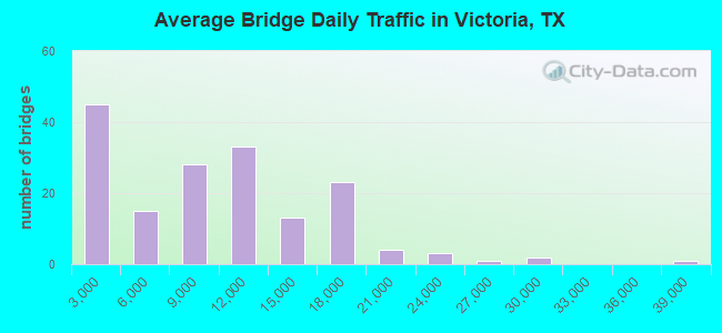
- 1,496,456Total average daily traffic
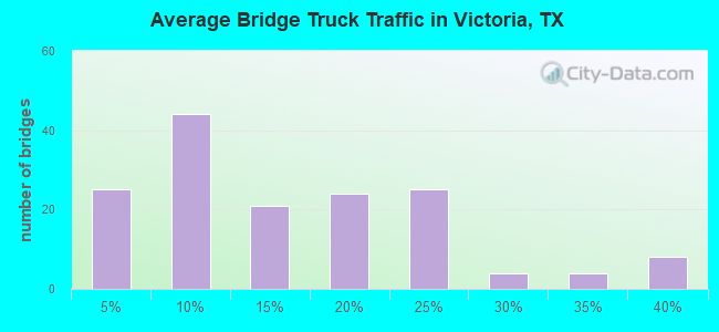
- 212,012Total average daily truck traffic
- National Bridge Inventory (NBI) Registered Bridges for Victoria
- No street view available for this location
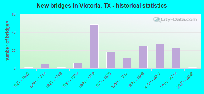
- New bridges - historical statistics
- 11920-1929
- 51930-1939
- 11940-1949
- 61950-1959
- 491960-1969
- 181970-1979
- 121980-1989
- 251990-1999
- 272000-2009
- 232010-2019
- 12020-2022
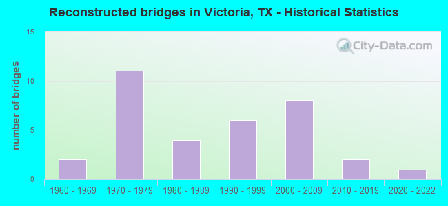
- Reconstructed bridges - Historical Statistics
- 21960-1969
- 111970-1979
- 41980-1989
- 61990-1999
- 82000-2009
- 22010-2019
- 12020-2022
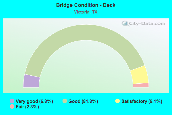
- Bridge Condition - Deck
- 6.8%Very good
- 81.8%Good
- 9.1%Satisfactory
- 2.3%Fair
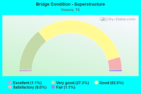
- Bridge Condition - Superstructure
- 1.1%Excellent
- 27.3%Very good
- 62.5%Good
- 8.0%Satisfactory
- 1.1%Fair
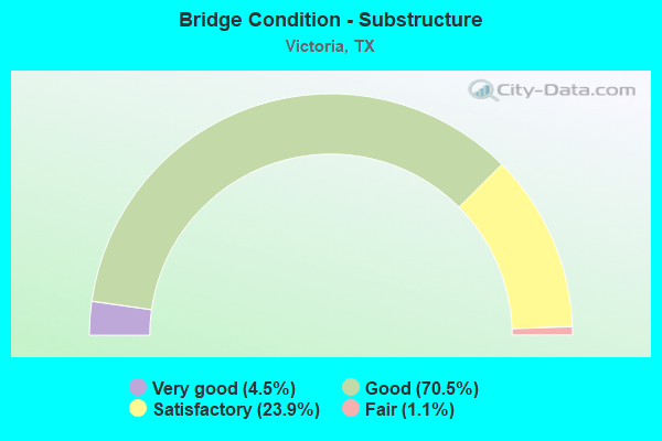
- Bridge Condition - Substructure
- 4.5%Very good
- 70.5%Good
- 23.9%Satisfactory
- 1.1%Fair
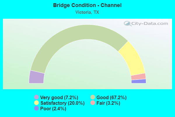
- Bridge Condition - Channel
- 7.2%Very good
- 67.2%Good
- 20.0%Satisfactory
- 3.2%Fair
- 2.4%Poor
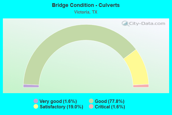
- Bridge Condition - Culverts
- 1.6%Very good
- 77.8%Good
- 19.0%Satisfactory
- 1.6%Critical
Find on map >> Show street view
Structure Number: 132350008804015, Location: 6.52 MI S OF US 77 (Lat: 28.730119, Lng: -97.139750), Route carried "on" structure: US 59, Year Built: 1930, Year Reconstructed: 1990, Status: Open, Structure Length: 22.49m (73.79ft), Average Daily Traffic: 2,000 (year 2016), Truck Traffic: 16%, Average Future Daily Traffic: 11,200 (year 2036), Features Intersected: COLETO CRK
Minimum Vertical Clearance: 30+ m (98+ ft), Kilometerpoint: 14.360, Lanes on structure: 2, Owner: State Highway Agency, Approaching Roadway Width: 12.2m (40.0ft), Material/Design: Prestressed concrete, Design/Construction: Stringer/Multi-beam, Number Of Spans In Main Unit: 1, Number Of Approach Spans: 15, Length of Maximum Span: 32.3m (106.0ft), Curb-To-Curb Width: 11.2m (36.7ft), Out-to-Out Width: 12.2m (40.0ft)
Condition: Deck: Good, Superstructure: Good, Substructure: Good, Channel: Satisfactory, Operating Rating: 32.7 metric tons, Method Used To Determine Operating Rating: Field evaluation and documented engineering judgment, Inventory Rating: 24.5 metric tons, Method Used To Determine Inventory Rating: Field evaluation and documented engineering judgment, Structural Evaluation: Equal to present minimum criteria, Deck Geometry: Equal to present minimum criteria, Waterway Adequacy: Superior to present desirable criteria, Approach Roadway Alignment: Equal to present desirable criteria, Length Of Structure Improvement: 21.40m (70.21ft), Designated Inspection Frequency: Every 24 months, Underwater Inspection Frequency: Every 60 months, Inspection Date: January 2021, Underwater Inspection Date: December 2016, Deck Structure Type: Concrete Cast-file-Place, Wearing Surface/Protective System: Wearing Surface: Bituminous
Find on map >> Show street view
Structure Number: 132350008805032, Location: 4.60 MI SW OF FM 1686 (Lat: 28.800375, Lng: -96.941344), Route carried "on" structure: US 59, Year Built: 1964, Status: Open, Structure Length: 3.05m (10.01ft), Average Daily Traffic: 10,560 (year 2013), Truck Traffic: 22%, Average Future Daily Traffic: 14,780 (year 2033), Design Load: HS 20, Features Intersected: LONE TREE CRK
Minimum Vertical Clearance: 30+ m (98+ ft), Kilometerpoint: 8.068, Lanes on structure: 2, Base Highway Network: Yes, Owner: State Highway Agency, Approaching Roadway Width: 12.2m (40.0ft), Material/Design: Concrete, Design/Construction: Slab, Number Of Spans In Main Unit: 4, Length of Maximum Span: 7.6m (24.9ft), Curb-To-Curb Width: 11.9m (39.0ft), Out-to-Out Width: 12.7m (41.7ft)
Condition: Deck: Good, Superstructure: Good, Substructure: Satisfactory, Channel: Satisfactory, Operating Rating: 67.1 metric tons, Method Used To Determine Operating Rating: Load Factor (LF), Inventory Rating: 39.9 metric tons, Method Used To Determine Inventory Rating: Load Factor (LF), Structural Evaluation: Equal to present minimum criteria, Deck Geometry: Equal to present minimum criteria, Waterway Adequacy: Equal to present minimum criteria, Approach Roadway Alignment: Equal to present desirable criteria, Designated Inspection Frequency: Every 24 months, Inspection Date: Febuary 2021, Deck Structure Type: Concrete Cast-file-Place, Wearing Surface/Protective System: Wearing Surface: Bituminous
Find on map >> Show street view
Structure Number: 132350008805033, Location: 4.60 MI SW OF FM 1686 (Lat: 28.800075, Lng: -96.941208), Route carried "on" structure: US 59, Year Built: 1964, Status: Open, Structure Length: 3.05m (10.01ft), Average Daily Traffic: 10,560 (year 2013), Truck Traffic: 22%, Average Future Daily Traffic: 14,780 (year 2033), Design Load: HS 20, Features Intersected: LONE TREE CRK
Minimum Vertical Clearance: 30+ m (98+ ft), Kilometerpoint: 8.068, Lanes on structure: 2, Base Highway Network: Yes, Owner: State Highway Agency, Approaching Roadway Width: 12.2m (40.0ft), Material/Design: Concrete, Design/Construction: Slab, Number Of Spans In Main Unit: 4, Length of Maximum Span: 7.6m (24.9ft), Curb-To-Curb Width: 11.9m (39.0ft), Out-to-Out Width: 12.7m (41.7ft)
Condition: Deck: Good, Superstructure: Good, Substructure: Satisfactory, Channel: Satisfactory, Operating Rating: 67.1 metric tons, Method Used To Determine Operating Rating: Load Factor (LF), Inventory Rating: 39.9 metric tons, Method Used To Determine Inventory Rating: Load Factor (LF), Structural Evaluation: Equal to present minimum criteria, Deck Geometry: Equal to present minimum criteria, Waterway Adequacy: Equal to present minimum criteria, Approach Roadway Alignment: Equal to present desirable criteria, Designated Inspection Frequency: Every 24 months, Inspection Date: Febuary 2021, Deck Structure Type: Concrete Cast-file-Place, Wearing Surface/Protective System: Wearing Surface: Bituminous
Find on map >> Show street view
Structure Number: 132350008805035, Location: 1.90 MI S OF FM 1686 (Lat: 28.830644, Lng: -96.912378), Route carried "on" structure: US 59, Year Built: 1964, Year Reconstructed: 2020, Status: Open, Structure Length: 1.16m (3.81ft), Average Daily Traffic: 19,843 (year 2020), Truck Traffic: 36%, Average Future Daily Traffic: 11,480 (year 2033), Features Intersected: MARCADO CRK
Minimum Vertical Clearance: 30+ m (98+ ft), Kilometerpoint: 3.674, Lanes on structure: 3, Owner: State Highway Agency, Approaching Roadway Width: 23.2m (76.1ft), Skew: 3 degrees, Material/Design: Concrete, Design/Construction: Culvert, Number Of Spans In Main Unit: 3, Length of Maximum Span: 3.0m (9.8ft), Curb-To-Curb Width: 23.2m (76.1ft), Out-to-Out Width: 39.3m (128.9ft)
Condition: Channel: Good, Culverts: Good, Operating Rating: 39.9 metric tons, Method Used To Determine Operating Rating: Load Factor (LF), Inventory Rating: 23.6 metric tons, Method Used To Determine Inventory Rating: Load Factor (LF), Structural Evaluation: Somewhat better than minimum adequacy, Deck Geometry: Superior to present desirable criteria, Waterway Adequacy: Equal to present minimum criteria, Approach Roadway Alignment: Equal to present desirable criteria, Designated Inspection Frequency: Every 24 months, Inspection Date: January 2021, Deck Structure Type: Concrete Cast-file-Place, Wearing Surface/Protective System: Wearing Surface: Bituminous
Find on map >> Show street view
Structure Number: 132350008805038, Location: 3.35 MI NE OF LP 463 (Lat: 28.851736, Lng: -96.892586), Route carried "on" structure: US 59, Year Built: 1964, Status: Open, Structure Length: 5.49m (18.01ft), Average Daily Traffic: 9,088 (year 2020), Truck Traffic: 36%, Average Future Daily Traffic: 5,740 (year 2033), Design Load: HS 20, Features Intersected: FM 1686
Minimum Vertical Clearance: 30+ m (98+ ft), Kilometerpoint: 0.592, Lanes on structure: 2, Lanes under structure: 2, Base Highway Network: Yes, Owner: State Highway Agency, Approaching Roadway Width: 12.2m (40.0ft), Material/Design: Prestressed concrete, Design/Construction: Stringer/Multi-beam, Number Of Spans In Main Unit: 3, Length of Maximum Span: 21.3m (69.9ft), Curb-To-Curb Width: 11.9m (39.0ft), Out-to-Out Width: 12.7m (41.7ft)
Condition: Deck: Good, Superstructure: Good, Substructure: Good, Operating Rating: 68.0 metric tons, Method Used To Determine Operating Rating: Load Factor (LF), Inventory Rating: 39.9 metric tons, Method Used To Determine Inventory Rating: Load Factor (LF), Structural Evaluation: Better than present minimum criteria, Deck Geometry: Equal to present minimum criteria, Underclear: Equal to present minimum criteria, Approach Roadway Alignment: Equal to present desirable criteria, Designated Inspection Frequency: Every 24 months, Inspection Date: January 2021, Deck Structure Type: Concrete Cast-file-Place, Wearing Surface/Protective System: Wearing Surface: Bituminous
Find on map >> Show street view
Structure Number: 132350008805039, Location: 3.35 MI NE OF LP 463 (Lat: 28.851425, Lng: -96.892317), Route carried "on" structure: US 59, Year Built: 1964, Status: Open, Structure Length: 5.49m (18.01ft), Average Daily Traffic: 13,305 (year 2020), Truck Traffic: 36%, Average Future Daily Traffic: 5,740 (year 2033), Design Load: HS 20, Features Intersected: FM 1686
Minimum Vertical Clearance: 30+ m (98+ ft), Kilometerpoint: 0.592, Lanes on structure: 2, Lanes under structure: 2, Base Highway Network: Yes, Owner: State Highway Agency, Approaching Roadway Width: 12.2m (40.0ft), Material/Design: Prestressed concrete, Design/Construction: Stringer/Multi-beam, Number Of Spans In Main Unit: 3, Length of Maximum Span: 21.3m (69.9ft), Curb-To-Curb Width: 12.1m (39.7ft), Out-to-Out Width: 12.7m (41.7ft)
Condition: Deck: Good, Superstructure: Satisfactory, Substructure: Satisfactory, Operating Rating: 54.4 metric tons, Method Used To Determine Operating Rating: Load Factor (LF), Inventory Rating: 39.9 metric tons, Method Used To Determine Inventory Rating: Load Factor (LF), Structural Evaluation: Equal to present minimum criteria, Deck Geometry: Equal to present minimum criteria, Underclear: Somewhat better than minimum adequacy, Approach Roadway Alignment: Equal to present desirable criteria, Designated Inspection Frequency: Every 24 months, Inspection Date: January 2021, Deck Structure Type: Concrete Cast-file-Place, Wearing Surface/Protective System: Wearing Surface: Bituminous
Find on map >> Show street view
Structure Number: 13235000880504, Location: 0.5 MI SW OF SH 185 (Lat: 28.761233, Lng: -96.983614), Route carried "on" structure: US 59, Year Built: 1965, Status: Open, Structure Length: 12.19m (39.99ft), Average Daily Traffic: 8,265 (year 2020), Truck Traffic: 22%, Average Future Daily Traffic: 12,300 (year 2033), Design Load: HS 20, Features Intersected: UNION PACIFIC RR
Minimum Vertical Clearance: 30+ m (98+ ft), Kilometerpoint: 13.995, Lanes on structure: 2, Owner: State Highway Agency, Approaching Roadway Width: 11.0m (36.1ft), Material/Design: Concrete, Design/Construction: Stringer/Multi-beam, Number Of Spans In Main Unit: 10, Length of Maximum Span: 12.2m (40.0ft), Curb-To-Curb Width: 9.4m (30.8ft), Out-to-Out Width: 10.1m (33.1ft)
Condition: Deck: Satisfactory, Superstructure: Satisfactory, Substructure: Satisfactory, Operating Rating: 67.1 metric tons, Method Used To Determine Operating Rating: Load Factor (LF), Inventory Rating: 39.9 metric tons, Method Used To Determine Inventory Rating: Load Factor (LF), Structural Evaluation: Equal to present minimum criteria, Deck Geometry: Meets minimum limits, Underclear: Equal to present minimum criteria, Approach Roadway Alignment: Equal to present desirable criteria, Designated Inspection Frequency: Every 24 months, Inspection Date: January 2021, Deck Structure Type: Concrete Cast-file-Place, Wearing Surface/Protective System: Wearing Surface: Bituminous
Find on map >> Show street view
Structure Number: 132350008805041, Location: 0.5 MI SW OF SH 185 (Lat: 28.760917, Lng: -96.983158), Route carried "on" structure: US 59, Year Built: 1965, Status: Open, Structure Length: 12.19m (39.99ft), Average Daily Traffic: 9,986 (year 2020), Truck Traffic: 22%, Average Future Daily Traffic: 12,300 (year 2033), Design Load: HS 20, Features Intersected: UNION PACIFIC RR
Minimum Vertical Clearance: 30+ m (98+ ft), Kilometerpoint: 13.995, Lanes on structure: 2, Owner: State Highway Agency, Approaching Roadway Width: 11.6m (38.1ft), Material/Design: Concrete, Design/Construction: Stringer/Multi-beam, Number Of Spans In Main Unit: 10, Length of Maximum Span: 12.2m (40.0ft), Curb-To-Curb Width: 9.4m (30.8ft), Out-to-Out Width: 10.1m (33.1ft)
Condition: Deck: Good, Superstructure: Good, Substructure: Satisfactory, Operating Rating: 67.1 metric tons, Method Used To Determine Operating Rating: Load Factor (LF), Inventory Rating: 39.9 metric tons, Method Used To Determine Inventory Rating: Load Factor (LF), Structural Evaluation: Equal to present minimum criteria, Deck Geometry: Meets minimum limits, Underclear: Somewhat better than minimum adequacy, Approach Roadway Alignment: Equal to present desirable criteria, Designated Inspection Frequency: Every 24 months, Inspection Date: January 2021, Deck Structure Type: Concrete Cast-file-Place, Wearing Surface/Protective System: Wearing Surface: Bituminous
Find on map >> Show street view
Structure Number: 132350008805042, Location: 1.1 MI SW OF US 87 (Lat: 28.766383, Lng: -96.977883), Route carried "on" structure: State highway 185, Year Built: 1965, Status: Open, Structure Length: 7.80m (25.59ft), Average Daily Traffic: 9,190 (year 2013), Truck Traffic: 7%, Average Future Daily Traffic: 12,870 (year 2033), Design Load: HS 20, Features Intersected: US 59
Minimum Vertical Clearance: 30+ m (98+ ft), Kilometerpoint: 12.844, Lanes on structure: 4, Lanes under structure: 4, Owner: State Highway Agency, Approaching Roadway Width: 19.5m (64.0ft), Skew: 2 degrees, Material/Design: Prestressed concrete, Design/Construction: Stringer/Multi-beam, Number Of Spans In Main Unit: 4, Length of Maximum Span: 21.3m (69.9ft), Curb or Sidewalk Widths: Left: 1.2m (3.9ft), Right: 1.2m (3.9ft), Curb-To-Curb Width: 20.9m (68.6ft), Out-to-Out Width: 24.0m (78.7ft)
Condition: Deck: Satisfactory, Superstructure: Fair, Substructure: Good, Operating Rating: 68.0 metric tons, Method Used To Determine Operating Rating: Load Factor (LF), Inventory Rating: 36.3 metric tons, Method Used To Determine Inventory Rating: Load Factor (LF), Structural Evaluation: Somewhat better than minimum adequacy, Deck Geometry: Superior to present desirable criteria, Underclear: Equal to present minimum criteria, Approach Roadway Alignment: Equal to present desirable criteria, Designated Inspection Frequency: Every 24 months, Inspection Date: January 2021, Deck Structure Type: Concrete Cast-file-Place
Find on map >> Show street view
Structure Number: 132350008805044, Location: 4.15 MI S OF SH 185 (Lat: 28.733603, Lng: -97.032167), Route carried "on" structure: US 59, Year Built: 1967, Status: Open, Structure Length: 0.73m (2.40ft), Average Daily Traffic: 18,251 (year 2020), Truck Traffic: 22%, Average Future Daily Traffic: 24,600 (year 2033), Design Load: HS 20, Features Intersected: DRAW
Minimum Vertical Clearance: 30+ m (98+ ft), Kilometerpoint: 19.940, Lanes on structure: 5, Owner: State Highway Agency, Approaching Roadway Width: 24.4m (80.1ft), Skew: 10 degrees, Material/Design: Concrete, Design/Construction: Culvert, Number Of Spans In Main Unit: 3, Length of Maximum Span: 2.1m (6.9ft)
Condition: Channel: Good, Culverts: Good, Operating Rating: 39.9 metric tons, Method Used To Determine Operating Rating: Load Factor (LF), Inventory Rating: 23.6 metric tons, Method Used To Determine Inventory Rating: Load Factor (LF), Structural Evaluation: Somewhat better than minimum adequacy, Waterway Adequacy: Equal to present minimum criteria, Approach Roadway Alignment: Equal to present desirable criteria, Designated Inspection Frequency: Every 24 months, Inspection Date: January 2021
Find on map >> Show street view
Structure Number: 132350008805045, Location: 3.30 MI SW OF SH 185 (Lat: 28.741875, Lng: -97.024572), Route carried "on" structure: US 59, Year Built: 1967, Status: Open, Structure Length: 19.51m (64.01ft), Average Daily Traffic: 8,265 (year 2020), Truck Traffic: 22%, Average Future Daily Traffic: 12,300 (year 2033), Design Load: HS 20, Features Intersected: GUADALUPE WEST REL#1
Minimum Vertical Clearance: 30+ m (98+ ft), Kilometerpoint: 18.572, Lanes on structure: 2, Base Highway Network: Yes, Owner: State Highway Agency, Approaching Roadway Width: 12.2m (40.0ft), Material/Design: Concrete, Design/Construction: Stringer/Multi-beam, Number Of Spans In Main Unit: 16, Length of Maximum Span: 12.2m (40.0ft), Curb-To-Curb Width: 10.1m (33.1ft), Out-to-Out Width: 10.7m (35.1ft)
Condition: Deck: Good, Superstructure: Good, Substructure: Good, Channel: Good, Operating Rating: 65.3 metric tons, Method Used To Determine Operating Rating: Load Factor (LF), Inventory Rating: 39.0 metric tons, Method Used To Determine Inventory Rating: Load Factor (LF), Structural Evaluation: Better than present minimum criteria, Deck Geometry: Meets minimum limits, Waterway Adequacy: Equal to present minimum criteria, Approach Roadway Alignment: Equal to present desirable criteria, Designated Inspection Frequency: Every 24 months, Inspection Date: Febuary 2021, Deck Structure Type: Concrete Cast-file-Place, Wearing Surface/Protective System: Wearing Surface: Bituminous
Find on map >> Show street view
Structure Number: 132350008805046, Location: 3.30 MI SW OF SH 185 (Lat: 28.741633, Lng: -97.024250), Route carried "on" structure: US 59, Year Built: 1967, Status: Open, Structure Length: 19.51m (64.01ft), Average Daily Traffic: 9,986 (year 2020), Truck Traffic: 22%, Average Future Daily Traffic: 12,300 (year 2033), Design Load: HS 20, Features Intersected: GUADALUPE WEST REL#1
Minimum Vertical Clearance: 30+ m (98+ ft), Kilometerpoint: 18.572, Lanes on structure: 2, Base Highway Network: Yes, Owner: State Highway Agency, Approaching Roadway Width: 12.2m (40.0ft), Material/Design: Concrete, Design/Construction: Stringer/Multi-beam, Number Of Spans In Main Unit: 16, Length of Maximum Span: 12.2m (40.0ft), Curb-To-Curb Width: 10.1m (33.1ft), Out-to-Out Width: 10.7m (35.1ft)
Condition: Deck: Good, Superstructure: Good, Substructure: Good, Channel: Good, Operating Rating: 65.3 metric tons, Method Used To Determine Operating Rating: Load Factor (LF), Inventory Rating: 39.0 metric tons, Method Used To Determine Inventory Rating: Load Factor (LF), Structural Evaluation: Better than present minimum criteria, Deck Geometry: Meets minimum limits, Waterway Adequacy: Equal to present minimum criteria, Approach Roadway Alignment: Equal to present desirable criteria, Designated Inspection Frequency: Every 24 months, Inspection Date: Febuary 2021, Deck Structure Type: Concrete Cast-file-Place, Wearing Surface/Protective System: Wearing Surface: Bituminous
Find on map >> Show street view
Structure Number: 132350008805047, Location: 3.00 MI SW OF SH 185 (Lat: 28.744136, Lng: -97.021031), Route carried "on" structure: US 59, Year Built: 1967, Status: Open, Structure Length: 28.65m (94.00ft), Average Daily Traffic: 8,265 (year 2020), Truck Traffic: 22%, Average Future Daily Traffic: 12,300 (year 2033), Design Load: HS 20, Features Intersected: GUADALUPE WEST REL#2
Minimum Vertical Clearance: 30+ m (98+ ft), Kilometerpoint: 18.081, Lanes on structure: 2, Base Highway Network: Yes, Owner: State Highway Agency, Approaching Roadway Width: 11.6m (38.1ft), Material/Design: Concrete, Design/Construction: Stringer/Multi-beam, Number Of Spans In Main Unit: 31, Length of Maximum Span: 9.1m (29.9ft), Curb-To-Curb Width: 10.1m (33.1ft), Out-to-Out Width: 10.7m (35.1ft)
Condition: Deck: Good, Superstructure: Good, Substructure: Good, Channel: Good, Operating Rating: 68.0 metric tons, Method Used To Determine Operating Rating: Load Factor (LF), Inventory Rating: 40.8 metric tons, Method Used To Determine Inventory Rating: Load Factor (LF), Structural Evaluation: Better than present minimum criteria, Deck Geometry: Meets minimum limits, Waterway Adequacy: Equal to present minimum criteria, Approach Roadway Alignment: Equal to present desirable criteria, Designated Inspection Frequency: Every 24 months, Inspection Date: Febuary 2021, Deck Structure Type: Concrete Cast-file-Place, Wearing Surface/Protective System: Wearing Surface: Bituminous
Find on map >> Show street view
Structure Number: 132350008805048, Location: 3.00 MI SW OF SH 185 (Lat: 28.743772, Lng: -97.020614), Route carried "on" structure: US 59, Year Built: 1967, Status: Open, Structure Length: 28.65m (94.00ft), Average Daily Traffic: 9,986 (year 2020), Truck Traffic: 22%, Average Future Daily Traffic: 12,300 (year 2033), Design Load: HS 20, Features Intersected: GUADALUPE WEST REL#2
Minimum Vertical Clearance: 30+ m (98+ ft), Kilometerpoint: 18.081, Lanes on structure: 2, Base Highway Network: Yes, Owner: State Highway Agency, Approaching Roadway Width: 11.6m (38.1ft), Material/Design: Concrete, Design/Construction: Stringer/Multi-beam, Number Of Spans In Main Unit: 31, Length of Maximum Span: 9.1m (29.9ft), Curb-To-Curb Width: 10.1m (33.1ft), Out-to-Out Width: 10.7m (35.1ft)
Condition: Deck: Good, Superstructure: Good, Substructure: Good, Channel: Good, Operating Rating: 68.0 metric tons, Method Used To Determine Operating Rating: Load Factor (LF), Inventory Rating: 40.8 metric tons, Method Used To Determine Inventory Rating: Load Factor (LF), Structural Evaluation: Better than present minimum criteria, Deck Geometry: Meets minimum limits, Waterway Adequacy: Equal to present minimum criteria, Approach Roadway Alignment: Equal to present desirable criteria, Designated Inspection Frequency: Every 24 months, Inspection Date: Febuary 2021, Deck Structure Type: Concrete Cast-file-Place, Wearing Surface/Protective System: Wearing Surface: Bituminous
Find on map >> Show street view
Structure Number: 132350008805049, Location: 2.10 SW OF SH 185 (Lat: 28.752125, Lng: -97.007267), Route carried "on" structure: US 59, Year Built: 1967, Year Reconstructed: 2010, Status: Open, Structure Length: 32.98m (108.20ft), Average Daily Traffic: 8,265 (year 2020), Truck Traffic: 22%, Average Future Daily Traffic: 12,300 (year 2033), Design Load: HS 20, Features Intersected: GUADALUPE RIVER
Minimum Vertical Clearance: 30+ m (98+ ft), Kilometerpoint: 16.546, Lanes on structure: 2, Base Highway Network: Yes, Owner: State Highway Agency, Approaching Roadway Width: 11.6m (38.1ft), Skew: 1 degrees, Material/Design: Steel continuous, Design/Construction: Stringer/Multi-beam, Number Of Spans In Main Unit: 3, Number Of Approach Spans: 7, Length of Maximum Span: 45.7m (149.9ft), Curb-To-Curb Width: 10.1m (33.1ft), Out-to-Out Width: 10.7m (35.1ft)
Condition: Deck: Good, Superstructure: Good, Substructure: Satisfactory, Channel: Poor, Operating Rating: 39.9 metric tons, Method Used To Determine Operating Rating: Load Factor (LF), Inventory Rating: 24.5 metric tons, Method Used To Determine Inventory Rating: Load Factor (LF), Structural Evaluation: Equal to present minimum criteria, Deck Geometry: Meets minimum limits, Waterway Adequacy: Superior to present desirable criteria, Approach Roadway Alignment: Equal to present desirable criteria, Length Of Structure Improvement: 14.23m (46.69ft), Designated Inspection Frequency: Every 24 months, Underwater Inspection Frequency: Every 60 months, Inspection Date: January 2021, Underwater Inspection Date: January 2018, Deck Structure Type: Concrete Cast-file-Place, Wearing Surface/Protective System: Wearing Surface: Bituminous
Find on map >> Show street view
Structure Number: 13235000880505, Location: 2.10 MI SW OF SH 185 (Lat: 28.751939, Lng: -97.006936), Route carried "on" structure: US 59, Year Built: 1967, Year Reconstructed: 2010, Status: Open, Structure Length: 33.38m (109.51ft), Average Daily Traffic: 9,986 (year 2020), Truck Traffic: 22%, Average Future Daily Traffic: 12,300 (year 2033), Design Load: HS 20, Features Intersected: GUADALUPE RIVER
Minimum Vertical Clearance: 30+ m (98+ ft), Kilometerpoint: 16.570, Lanes on structure: 2, Base Highway Network: Yes, Owner: State Highway Agency, Approaching Roadway Width: 11.6m (38.1ft), Skew: 1 degrees, Material/Design: Steel continuous, Design/Construction: Stringer/Multi-beam, Number Of Spans In Main Unit: 3, Number Of Approach Spans: 7, Length of Maximum Span: 45.7m (149.9ft), Curb-To-Curb Width: 10.3m (33.8ft), Out-to-Out Width: 10.7m (35.1ft)
Condition: Deck: Good, Superstructure: Good, Substructure: Satisfactory, Channel: Fair, Operating Rating: 39.9 metric tons, Method Used To Determine Operating Rating: Load Factor (LF), Inventory Rating: 24.5 metric tons, Method Used To Determine Inventory Rating: Load Factor (LF), Structural Evaluation: Equal to present minimum criteria, Deck Geometry: Meets minimum limits, Waterway Adequacy: Superior to present desirable criteria, Approach Roadway Alignment: Equal to present desirable criteria, Length Of Structure Improvement: 12.19m (39.99ft), Designated Inspection Frequency: Every 24 months, Underwater Inspection Frequency: Every 60 months, Inspection Date: January 2021, Underwater Inspection Date: January 2018, Deck Structure Type: Concrete Cast-file-Place, Wearing Surface/Protective System: Wearing Surface: Bituminous
Find on map >> Show street view
Structure Number: 132350008805051, Location: 1.50 MI SW OF SH 185 (Lat: 28.755758, Lng: -96.999075), Route carried "on" structure: US 59, Year Built: 1967, Status: Open, Structure Length: 16.64m (54.59ft), Average Daily Traffic: 8,265 (year 2020), Truck Traffic: 22%, Average Future Daily Traffic: 12,300 (year 2033), Design Load: HS 20, Features Intersected: GUADALUPE EAST REL#1
Minimum Vertical Clearance: 30+ m (98+ ft), Kilometerpoint: 15.641, Lanes on structure: 2, Owner: State Highway Agency, Approaching Roadway Width: 11.6m (38.1ft), Material/Design: Concrete, Design/Construction: Stringer/Multi-beam, Number Of Spans In Main Unit: 18, Length of Maximum Span: 9.1m (29.9ft), Curb-To-Curb Width: 10.1m (33.1ft), Out-to-Out Width: 10.7m (35.1ft)
Condition: Deck: Good, Superstructure: Good, Substructure: Good, Channel: Good, Operating Rating: 68.0 metric tons, Method Used To Determine Operating Rating: Load Factor (LF), Inventory Rating: 40.8 metric tons, Method Used To Determine Inventory Rating: Load Factor (LF), Structural Evaluation: Better than present minimum criteria, Deck Geometry: Meets minimum limits, Waterway Adequacy: Equal to present minimum criteria, Approach Roadway Alignment: Equal to present desirable criteria, Designated Inspection Frequency: Every 24 months, Inspection Date: January 2021, Deck Structure Type: Concrete Cast-file-Place, Wearing Surface/Protective System: Wearing Surface: Bituminous
Find on map >> Show street view
Structure Number: 132350008805052, Location: 1.50 MI SW OF SH 185 (Lat: 28.755192, Lng: -96.998936), Route carried "on" structure: US 59, Year Built: 1967, Status: Open, Structure Length: 16.64m (54.59ft), Average Daily Traffic: 9,986 (year 2020), Truck Traffic: 22%, Average Future Daily Traffic: 12,300 (year 2033), Design Load: HS 20, Features Intersected: GUADALUPE EAST REL#1
Minimum Vertical Clearance: 30+ m (98+ ft), Kilometerpoint: 15.641, Lanes on structure: 2, Owner: State Highway Agency, Approaching Roadway Width: 11.6m (38.1ft), Material/Design: Concrete, Design/Construction: Stringer/Multi-beam, Number Of Spans In Main Unit: 18, Length of Maximum Span: 9.1m (29.9ft), Curb-To-Curb Width: 10.1m (33.1ft), Out-to-Out Width: 10.7m (35.1ft)
Condition: Deck: Good, Superstructure: Good, Substructure: Good, Channel: Good, Operating Rating: 68.0 metric tons, Method Used To Determine Operating Rating: Load Factor (LF), Inventory Rating: 40.8 metric tons, Method Used To Determine Inventory Rating: Load Factor (LF), Structural Evaluation: Better than present minimum criteria, Deck Geometry: Meets minimum limits, Waterway Adequacy: Equal to present minimum criteria, Approach Roadway Alignment: Equal to present desirable criteria, Designated Inspection Frequency: Every 24 months, Inspection Date: January 2021, Deck Structure Type: Concrete Cast-file-Place, Wearing Surface/Protective System: Wearing Surface: Bituminous
Find on map >> Show street view
Structure Number: 132350008805053, Location: 0.90 MI SW OF SH 185 (Lat: 28.757614, Lng: -96.991017), Route carried "on" structure: US 59, Year Built: 1967, Status: Open, Structure Length: 30.51m (100.10ft), Average Daily Traffic: 8,265 (year 2020), Truck Traffic: 22%, Average Future Daily Traffic: 12,300 (year 2033), Design Load: HS 20, Features Intersected: GUADALUPE EAST REL#2
Minimum Vertical Clearance: 30+ m (98+ ft), Kilometerpoint: 14.753, Lanes on structure: 2, Owner: State Highway Agency, Approaching Roadway Width: 11.6m (38.1ft), Material/Design: Concrete, Design/Construction: Stringer/Multi-beam, Number Of Spans In Main Unit: 33, Length of Maximum Span: 9.1m (29.9ft), Curb-To-Curb Width: 10.1m (33.1ft), Out-to-Out Width: 10.7m (35.1ft)
Condition: Deck: Good, Superstructure: Good, Substructure: Good, Channel: Good, Operating Rating: 68.0 metric tons, Method Used To Determine Operating Rating: Load Factor (LF), Inventory Rating: 40.8 metric tons, Method Used To Determine Inventory Rating: Load Factor (LF), Structural Evaluation: Better than present minimum criteria, Deck Geometry: Meets minimum limits, Waterway Adequacy: Equal to present minimum criteria, Approach Roadway Alignment: Equal to present desirable criteria, Designated Inspection Frequency: Every 24 months, Inspection Date: January 2021, Deck Structure Type: Concrete Cast-file-Place, Wearing Surface/Protective System: Wearing Surface: Bituminous
Find on map >> Show street view
Structure Number: 132350008805054, Location: 0.90 MI SW OF SH 185 (Lat: 28.757131, Lng: -96.990742), Route carried "on" structure: US 59, Year Built: 1967, Status: Open, Structure Length: 30.51m (100.10ft), Average Daily Traffic: 9,986 (year 2020), Truck Traffic: 22%, Average Future Daily Traffic: 12,300 (year 2033), Design Load: HS 20, Features Intersected: GUADALUPE EAST REL#2
Minimum Vertical Clearance: 30+ m (98+ ft), Kilometerpoint: 14.753, Lanes on structure: 2, Owner: State Highway Agency, Approaching Roadway Width: 11.6m (38.1ft), Material/Design: Concrete, Design/Construction: Stringer/Multi-beam, Number Of Spans In Main Unit: 33, Length of Maximum Span: 9.1m (29.9ft), Curb-To-Curb Width: 10.1m (33.1ft), Out-to-Out Width: 10.7m (35.1ft)
Condition: Deck: Good, Superstructure: Good, Substructure: Good, Channel: Good, Operating Rating: 68.0 metric tons, Method Used To Determine Operating Rating: Load Factor (LF), Inventory Rating: 40.8 metric tons, Method Used To Determine Inventory Rating: Load Factor (LF), Structural Evaluation: Better than present minimum criteria, Deck Geometry: Meets minimum limits, Waterway Adequacy: Equal to present minimum criteria, Approach Roadway Alignment: Equal to present desirable criteria, Designated Inspection Frequency: Every 24 months, Inspection Date: January 2021, Deck Structure Type: Concrete Cast-file-Place, Wearing Surface/Protective System: Wearing Surface: Bituminous
Find on map >> Show street view
Structure Number: 132350008805055, Location: 0.70 MI SW OF SH 185 (Lat: 28.758981, Lng: -96.986253), Route carried "on" structure: US 59, Year Built: 1967, Status: Open, Structure Length: 6.68m (21.92ft), Average Daily Traffic: 8,265 (year 2020), Truck Traffic: 22%, Average Future Daily Traffic: 12,300 (year 2033), Design Load: HS 20, Features Intersected: GUADALUPE RI E REL #3
Minimum Vertical Clearance: 30+ m (98+ ft), Kilometerpoint: 14.388, Lanes on structure: 2, Owner: State Highway Agency, Approaching Roadway Width: 12.2m (40.0ft), Material/Design: Concrete, Design/Construction: Stringer/Multi-beam, Number Of Spans In Main Unit: 7, Length of Maximum Span: 9.4m (30.8ft), Curb-To-Curb Width: 12.4m (40.7ft), Out-to-Out Width: 12.9m (42.3ft)
Condition: Deck: Good, Superstructure: Good, Substructure: Good, Channel: Good, Operating Rating: 68.0 metric tons, Method Used To Determine Operating Rating: Load Factor (LF), Inventory Rating: 40.8 metric tons, Method Used To Determine Inventory Rating: Load Factor (LF), Structural Evaluation: Better than present minimum criteria, Deck Geometry: Better than present minimum criteria, Waterway Adequacy: Equal to present minimum criteria, Approach Roadway Alignment: Equal to present desirable criteria, Designated Inspection Frequency: Every 24 months, Inspection Date: January 2021, Deck Structure Type: Concrete Cast-file-Place, Wearing Surface/Protective System: Wearing Surface: Bituminous
Find on map >> Show street view
Structure Number: 132350008805056, Location: 0.70 MI SW OF SH 185 (Lat: 28.758622, Lng: -96.985911), Route carried "on" structure: US 59, Year Built: 1967, Status: Open, Structure Length: 6.40m (21.00ft), Average Daily Traffic: 9,986 (year 2020), Truck Traffic: 22%, Average Future Daily Traffic: 12,300 (year 2033), Design Load: HS 20, Features Intersected: GUADALUPE RI E REL #3
Minimum Vertical Clearance: 30+ m (98+ ft), Kilometerpoint: 14.388, Lanes on structure: 2, Owner: State Highway Agency, Approaching Roadway Width: 12.2m (40.0ft), Material/Design: Concrete, Design/Construction: Stringer/Multi-beam, Number Of Spans In Main Unit: 7, Length of Maximum Span: 9.1m (29.9ft), Curb-To-Curb Width: 12.4m (40.7ft), Out-to-Out Width: 12.9m (42.3ft)
Condition: Deck: Good, Superstructure: Good, Substructure: Good, Channel: Good, Operating Rating: 68.0 metric tons, Method Used To Determine Operating Rating: Load Factor (LF), Inventory Rating: 40.8 metric tons, Method Used To Determine Inventory Rating: Load Factor (LF), Structural Evaluation: Better than present minimum criteria, Deck Geometry: Better than present minimum criteria, Waterway Adequacy: Equal to present minimum criteria, Approach Roadway Alignment: Equal to present desirable criteria, Designated Inspection Frequency: Every 24 months, Inspection Date: January 2021, Deck Structure Type: Concrete Cast-file-Place, Wearing Surface/Protective System: Wearing Surface: Bituminous
Find on map >> Show street view
Structure Number: 132350008805059, Location: AT JCT US 59 & SP 91 (Lat: 28.729594, Lng: -97.033672), Route carried "on" structure: US 59, Year Built: 1967, Status: Open, Structure Length: 20.79m (68.21ft), Average Daily Traffic: 4,045 (year 2020), Truck Traffic: 21%, Average Future Daily Traffic: 4,350 (year 2033), Design Load: H 20, Features Intersected: SP 91
Minimum Vertical Clearance: 30+ m (98+ ft), Kilometerpoint: 20.239, Lanes on structure: 2, Lanes under structure: 4, Base Highway Network: Yes, Owner: State Highway Agency, Approaching Roadway Width: 10.1m (33.1ft), Material/Design: Prestressed concrete, Design/Construction: Stringer/Multi-beam, Number Of Spans In Main Unit: 9, Length of Maximum Span: 24.7m (81.0ft), Curb-To-Curb Width: 10.1m (33.1ft), Out-to-Out Width: 10.8m (35.4ft)
Condition: Deck: Good, Superstructure: Good, Substructure: Satisfactory, Operating Rating: 63.5 metric tons, Method Used To Determine Operating Rating: Load Factor (LF), Inventory Rating: 22.7 metric tons, Method Used To Determine Inventory Rating: Load Factor (LF), Structural Evaluation: Somewhat better than minimum adequacy, Deck Geometry: Meets minimum limits, Underclear: Somewhat better than minimum adequacy, Approach Roadway Alignment: Equal to present desirable criteria, Designated Inspection Frequency: Every 24 months, Critical Feature Inspection Frequency: Every 24 months, Inspection Date: Febuary 2021, Critical Feature Inspection Date: March 2020, Deck Structure Type: Concrete Cast-file-Place, Wearing Surface/Protective System: Wearing Surface: Bituminous
Find on map >> Show street view
Structure Number: 132350008805066, Location: 0.20 MI S OF LP 463 (Lat: 28.814125, Lng: -96.929361), Route carried "on" structure: US 59, Year Built: 1988, Status: Open, Structure Length: 0.91m (2.99ft), Average Daily Traffic: 8,200 (year 2013), Truck Traffic: 36%, Average Future Daily Traffic: 11,480 (year 2033), Features Intersected: DRAIN
Minimum Vertical Clearance: 30+ m (98+ ft), Kilometerpoint: 6.157, Lanes on structure: 2, Owner: State Highway Agency, Approaching Roadway Width: 13.1m (43.0ft), Skew: 3 degrees, Material/Design: Concrete, Design/Construction: Culvert, Number Of Spans In Main Unit: 3, Length of Maximum Span: 2.4m (7.9ft), Curb-To-Curb Width: 12.3m (40.4ft), Out-to-Out Width: 17.5m (57.4ft)
Condition: Channel: Very good, Culverts: Good, Operating Rating: 32.7 metric tons, Method Used To Determine Operating Rating: Field evaluation and documented engineering judgment, Inventory Rating: 24.5 metric tons, Method Used To Determine Inventory Rating: Field evaluation and documented engineering judgment, Structural Evaluation: Equal to present minimum criteria, Deck Geometry: Somewhat better than minimum adequacy, Waterway Adequacy: Equal to present minimum criteria, Approach Roadway Alignment: Equal to present desirable criteria, Designated Inspection Frequency: Every 24 months, Inspection Date: January 2021, Deck Structure Type: Concrete Cast-file-Place, Wearing Surface/Protective System: Wearing Surface: Bituminous
Find on map >> Show street view
Structure Number: 132350008805067, Location: 0.20 MI S OF LP 463 (Lat: 28.813131, Lng: -96.929158), Route carried "on" structure: US 59, Year Built: 1964, Year Reconstructed: 1988, Status: Open, Structure Length: 1.28m (4.20ft), Average Daily Traffic: 8,200 (year 2013), Truck Traffic: 36%, Average Future Daily Traffic: 11,480 (year 2033), Design Load: H 20, Features Intersected: DRAIN
Minimum Vertical Clearance: 30+ m (98+ ft), Kilometerpoint: 4.495, Lanes on structure: 4, Base Highway Network: Yes, Owner: State Highway Agency, Approaching Roadway Width: 24.4m (80.1ft), Skew: 4 degrees, Material/Design: Concrete, Design/Construction: Culvert, Number Of Spans In Main Unit: 4, Length of Maximum Span: 2.4m (7.9ft)
Condition: Channel: Very good, Culverts: Good, Operating Rating: 39.9 metric tons, Method Used To Determine Operating Rating: Load Factor (LF), Inventory Rating: 23.6 metric tons, Method Used To Determine Inventory Rating: Load Factor (LF), Structural Evaluation: Somewhat better than minimum adequacy, Waterway Adequacy: Equal to present minimum criteria, Approach Roadway Alignment: Equal to present desirable criteria, Designated Inspection Frequency: Every 24 months, Inspection Date: January 2021
Find on map >> Show street view
Structure Number: 132350008805068, Location: 3.50 MI NE OF US 87 (Lat: 28.815550, Lng: -96.927044), Route carried "on" structure: US 59, Year Built: 1990, Status: Open, Structure Length: 10.97m (35.99ft), Average Daily Traffic: 4,100 (year 2013), Truck Traffic: 36%, Average Future Daily Traffic: 5,740 (year 2033), Design Load: HS 20, Features Intersected: LP 463
Minimum Vertical Clearance: 30+ m (98+ ft), Kilometerpoint: 5.818, Lanes on structure: 2, Lanes under structure: 6, Base Highway Network: Yes, Owner: State Highway Agency, Approaching Roadway Width: 11.6m (38.1ft), Material/Design: Prestressed concrete, Design/Construction: Stringer/Multi-beam, Number Of Spans In Main Unit: 3, Length of Maximum Span: 36.6m (120.1ft), Curb-To-Curb Width: 11.3m (37.1ft), Out-to-Out Width: 12.2m (40.0ft)
Condition: Deck: Satisfactory, Superstructure: Good, Substructure: Good, Operating Rating: 54.4 metric tons, Method Used To Determine Operating Rating: Assigned rating based on Load Factor Design (LFD) reported in metric tons, Inventory Rating: 32.7 metric tons, Method Used To Determine Inventory Rating: Assigned rating based on Load Factor Design (LFD) reported in metric tons, Structural Evaluation: Better than present minimum criteria, Deck Geometry: Somewhat better than minimum adequacy, Underclear: Better than present minimum criteria, Approach Roadway Alignment: Equal to present desirable criteria, Designated Inspection Frequency: Every 24 months, Inspection Date: January 2021, Deck Structure Type: Concrete Precast Panels
Find on map >> Show street view
Structure Number: 132350008805069, Location: 3.50 MI NE OF US 87 (Lat: 28.815356, Lng: -96.926822), Route carried "on" structure: US 59, Year Built: 1990, Status: Open, Structure Length: 10.97m (35.99ft), Average Daily Traffic: 4,100 (year 2013), Truck Traffic: 36%, Average Future Daily Traffic: 5,740 (year 2033), Design Load: HS 20, Features Intersected: LP 463
Minimum Vertical Clearance: 30+ m (98+ ft), Kilometerpoint: 5.818, Lanes on structure: 2, Lanes under structure: 6, Base Highway Network: Yes, Owner: State Highway Agency, Approaching Roadway Width: 11.6m (38.1ft), Material/Design: Prestressed concrete, Design/Construction: Stringer/Multi-beam, Number Of Spans In Main Unit: 3, Length of Maximum Span: 36.6m (120.1ft), Curb-To-Curb Width: 11.3m (37.1ft), Out-to-Out Width: 12.2m (40.0ft)
Condition: Deck: Satisfactory, Superstructure: Good, Substructure: Good, Operating Rating: 54.4 metric tons, Method Used To Determine Operating Rating: Assigned rating based on Load Factor Design (LFD) reported in metric tons, Inventory Rating: 32.7 metric tons, Method Used To Determine Inventory Rating: Assigned rating based on Load Factor Design (LFD) reported in metric tons, Structural Evaluation: Better than present minimum criteria, Deck Geometry: Somewhat better than minimum adequacy, Underclear: Better than present minimum criteria, Approach Roadway Alignment: Equal to present desirable criteria, Designated Inspection Frequency: Every 24 months, Inspection Date: January 2021, Deck Structure Type: Concrete Precast Panels
Find on map >> Show street view
Structure Number: 132350008805194, Location: 0.35 MI SW OF FM 1686 (Lat: 28.849219, Lng: -96.896694), Route carried "on" structure: US 59, Year Built: 1964, Status: Open, Structure Length: 35.23m (115.58ft), Average Daily Traffic: 9,088 (year 2020), Truck Traffic: 31%, Average Future Daily Traffic: 34,520 (year 2035), Design Load: HS 20, Features Intersected: BU 59T NB SKYTOP ST
Minimum Vertical Clearance: 30+ m (98+ ft), Kilometerpoint: 1.110, Lanes on structure: 2, Lanes under structure: 5, Base Highway Network: Yes, Owner: State Highway Agency, Approaching Roadway Width: 12.2m (40.0ft), Material/Design: Prestressed concrete, Design/Construction: Stringer/Multi-beam, Number Of Spans In Main Unit: 17, Number Of Approach Spans: 2, Length of Maximum Span: 22.6m (74.1ft), Curb-To-Curb Width: 9.0m (29.5ft), Out-to-Out Width: 9.7m (31.8ft)
Condition: Deck: Good, Superstructure: Very good, Substructure: Satisfactory, Operating Rating: 68.0 metric tons, Method Used To Determine Operating Rating: Load Factor (LF), Inventory Rating: 31.7 metric tons, Method Used To Determine Inventory Rating: Load Factor (LF), Structural Evaluation: Equal to present minimum criteria, Deck Geometry: Meets minimum limits, Underclear: Meets minimum limits, Approach Roadway Alignment: Equal to present desirable criteria, Length Of Structure Improvement: 35.23m (115.58ft), Designated Inspection Frequency: Every 24 months, Critical Feature Inspection Frequency: Every 24 months, Inspection Date: January 2021, Critical Feature Inspection Date: July 2020, Bridge Improvement Cost: $67,000, Roadway Improvement Cost: $17,000, Total Project Cost: $84,000, Deck Structure Type: Concrete Cast-file-Place, Wearing Surface/Protective System: Wearing Surface: Bituminous
Find on map >> Show street view
Structure Number: 132350008805195, Location: 0.35 MI SW OF FM 1686 (Lat: 28.846858, Lng: -96.898336), Route carried "on" structure: US 59, Year Built: 1964, Status: Open, Structure Length: 35.48m (116.40ft), Average Daily Traffic: 10,755 (year 2020), Truck Traffic: 36%, Average Future Daily Traffic: 34,520 (year 2035), Design Load: HS 20, Features Intersected: BU 59T NB SKYTOP ST
Minimum Vertical Clearance: 30+ m (98+ ft), Kilometerpoint: 0.980, Lanes on structure: 2, Lanes under structure: 4, Base Highway Network: Yes, Owner: State Highway Agency, Approaching Roadway Width: 12.2m (40.0ft), Material/Design: Prestressed concrete, Design/Construction: Stringer/Multi-beam, Number Of Spans In Main Unit: 15, Number Of Approach Spans: 4, Length of Maximum Span: 23.8m (78.1ft), Curb-To-Curb Width: 9.0m (29.5ft), Out-to-Out Width: 9.7m (31.8ft)
Condition: Deck: Good, Superstructure: Very good, Substructure: Satisfactory, Operating Rating: 68.0 metric tons, Method Used To Determine Operating Rating: Load Factor (LF), Inventory Rating: 31.7 metric tons, Method Used To Determine Inventory Rating: Load Factor (LF), Structural Evaluation: Equal to present minimum criteria, Deck Geometry: Meets minimum limits, Underclear: Meets minimum limits, Approach Roadway Alignment: Equal to present desirable criteria, Length Of Structure Improvement: 35.48m (116.40ft), Designated Inspection Frequency: Every 24 months, Critical Feature Inspection Frequency: Every 24 months, Inspection Date: January 2021, Critical Feature Inspection Date: July 2020, Bridge Improvement Cost: $68,000, Roadway Improvement Cost: $17,000, Total Project Cost: $85,000, Deck Structure Type: Concrete Cast-file-Place, Wearing Surface/Protective System: Wearing Surface: Bituminous
Find on map >> Show street view
Structure Number: 1323500088052, Location: 4.60 MI SW OF 1686 (Lat: 28.799706, Lng: -96.941231), Route carried "on" structure: US 59, Year Built: 2015, Status: Open, Structure Length: 4.57m (14.99ft), Average Daily Traffic: 28,930 (year 2012), Truck Traffic: 22%, Average Future Daily Traffic: 31,070 (year 2030), Design Load: HL 93, Features Intersected: LONE TREE CREEK
Minimum Vertical Clearance: 30+ m (98+ ft), Kilometerpoint: 8.068, Lanes on structure: 2, Owner: State Highway Agency, Approaching Roadway Width: 11.6m (38.1ft), Material/Design: Prestressed concrete, Design/Construction: Slab, Number Of Spans In Main Unit: 3, Length of Maximum Span: 15.2m (49.9ft), Curb-To-Curb Width: 11.6m (38.1ft), Out-to-Out Width: 12.2m (40.0ft)
Condition: Deck: Good, Superstructure: Very good, Substructure: Good, Channel: Good, Operating Rating: 54.4 metric tons, Method Used To Determine Operating Rating: Assigned ratings based on Load and Resistance Factor Design (LRFD) reported in metric tons, Inventory Rating: 32.7 metric tons, Method Used To Determine Inventory Rating: Assigned ratings based on Load and Resistance Factor Design (LRFD) reported in metric tons, Structural Evaluation: Better than present minimum criteria, Deck Geometry: Equal to present minimum criteria, Waterway Adequacy: Superior to present desirable criteria, Approach Roadway Alignment: Equal to present desirable criteria, Designated Inspection Frequency: Every 24 months, Inspection Date: Febuary 2021, Deck Structure Type: Concrete Cast-file-Place
Find on map >> Show street view
Structure Number: 132350008805201, Location: 4.60 MI SW OF 1686 (Lat: 28.800589, Lng: -96.941400), Route carried "on" structure: US 59, Year Built: 2015, Status: Open, Structure Length: 4.57m (14.99ft), Average Daily Traffic: 28,930 (year 2012), Truck Traffic: 22%, Average Future Daily Traffic: 31,070 (year 2030), Design Load: HL 93, Features Intersected: LONE STAR CREEK
Minimum Vertical Clearance: 30+ m (98+ ft), Kilometerpoint: 8.068, Lanes on structure: 2, Owner: State Highway Agency, Approaching Roadway Width: 11.6m (38.1ft), Material/Design: Prestressed concrete, Design/Construction: Slab, Number Of Spans In Main Unit: 3, Length of Maximum Span: 15.2m (49.9ft), Curb-To-Curb Width: 11.6m (38.1ft), Out-to-Out Width: 12.2m (40.0ft)
Condition: Deck: Good, Superstructure: Very good, Substructure: Good, Channel: Good, Operating Rating: 54.4 metric tons, Method Used To Determine Operating Rating: Assigned ratings based on Load and Resistance Factor Design (LRFD) reported in metric tons, Inventory Rating: 32.7 metric tons, Method Used To Determine Inventory Rating: Assigned ratings based on Load and Resistance Factor Design (LRFD) reported in metric tons, Structural Evaluation: Better than present minimum criteria, Deck Geometry: Equal to present minimum criteria, Waterway Adequacy: Superior to present desirable criteria, Approach Roadway Alignment: Equal to present desirable criteria, Designated Inspection Frequency: Every 24 months, Inspection Date: Febuary 2021, Deck Structure Type: Concrete Cast-file-Place
Find on map >> Show street view
Structure Number: 132350008805202, Location: 0.27 Mi S of LP 463 (Lat: 28.812003, Lng: -96.929083), Route carried "on" structure: ServiceUS 59, Year Built: 2015, Status: Open, Structure Length: 1.37m (4.49ft), Average Daily Traffic: 15,470 (year 2011), Truck Traffic: 26%, Average Future Daily Traffic: 21,660 (year 2031), Design Load: HL 93, Features Intersected: Drain
Minimum Vertical Clearance: 30+ m (98+ ft), Kilometerpoint: 4.495, Lanes on structure: 2, Owner: State Highway Agency, Approaching Roadway Width: 11.6m (38.1ft), Skew: 4 degrees, Material/Design: Concrete, Design/Construction: Culvert, Number Of Spans In Main Unit: 3, Length of Maximum Span: 4.0m (13.1ft), Curb-To-Curb Width: 11.6m (38.1ft), Out-to-Out Width: 17.1m (56.1ft)
Condition: Channel: Good, Culverts: Good, Operating Rating: 54.4 metric tons, Method Used To Determine Operating Rating: Assigned ratings based on Load and Resistance Factor Design (LRFD) reported in metric tons, Inventory Rating: 32.7 metric tons, Method Used To Determine Inventory Rating: Assigned ratings based on Load and Resistance Factor Design (LRFD) reported in metric tons, Structural Evaluation: Better than present minimum criteria, Deck Geometry: Equal to present minimum criteria, Waterway Adequacy: Better than present minimum criteria, Approach Roadway Alignment: Equal to present desirable criteria, Designated Inspection Frequency: Every 24 months, Inspection Date: January 2021, Deck Structure Type: Concrete Cast-file-Place, Wearing Surface/Protective System: Wearing Surface: Bituminous
Find on map >> Show street view
Structure Number: 132350008805203, Location: 1.1 MI NE OF SH 185 (Lat: 28.778236, Lng: -96.963733), Route carried "on" structure: US 59, Year Built: 2015, Status: Open, Structure Length: 14.02m (46.00ft), Average Daily Traffic: 10,640 (year 2011), Truck Traffic: 22%, Average Future Daily Traffic: 14,900 (year 2031), Design Load: HL 93, Features Intersected: US 87 & UPRR
Minimum Vertical Clearance: 30+ m (98+ ft), Kilometerpoint: 11.356, Lanes on structure: 6, Lanes under structure: 6, Owner: State Highway Agency, Approaching Roadway Width: 34.1m (111.9ft), Skew: 1 degrees, Material/Design: Prestressed concrete, Design/Construction: Stringer/Multi-beam, Number Of Spans In Main Unit: 6, Length of Maximum Span: 27.1m (88.9ft), Curb-To-Curb Width: 34.1m (111.9ft), Out-to-Out Width: 35.4m (116.1ft)
Condition: Deck: Good, Superstructure: Very good, Substructure: Good, Operating Rating: 54.4 metric tons, Method Used To Determine Operating Rating: Assigned ratings based on Load and Resistance Factor Design (LRFD) reported in metric tons, Inventory Rating: 32.7 metric tons, Method Used To Determine Inventory Rating: Assigned ratings based on Load and Resistance Factor Design (LRFD) reported in metric tons, Structural Evaluation: Better than present minimum criteria, Deck Geometry: Superior to present desirable criteria, Underclear: Meets minimum limits, Approach Roadway Alignment: Equal to present desirable criteria, Designated Inspection Frequency: Every 24 months, Inspection Date: January 2021, Deck Structure Type: Concrete Precast Panels
Find on map >> Show street view
Structure Number: 132350008805204, Location: US 59 AT HANSELMAN ROAD (Lat: 28.793336, Lng: -96.947953), Route carried "on" structure: US 59, Year Built: 2017, Status: Open, Structure Length: 6.49m (21.29ft), Average Daily Traffic: 22,010 (year 2012), Truck Traffic: 26%, Average Future Daily Traffic: 30,810 (year 2032), Design Load: HL 93, Features Intersected: HANSELMAN ROAD
Minimum Vertical Clearance: 30+ m (98+ ft), Kilometerpoint: 0.000, Lanes on structure: 4, Lanes under structure: 5, Base Highway Network: Yes, Owner: State Highway Agency, Approaching Roadway Width: 23.3m (76.4ft), Skew: 30 degrees, Material/Design: Prestressed concrete, Design/Construction: Stringer/Multi-beam, Number Of Spans In Main Unit: 3, Length of Maximum Span: 22.9m (75.1ft), Curb-To-Curb Width: 23.3m (76.4ft), Out-to-Out Width: 24.4m (80.1ft)
Condition: Deck: Good, Superstructure: Very good, Substructure: Very good, Operating Rating: 54.4 metric tons, Method Used To Determine Operating Rating: Assigned ratings based on Load and Resistance Factor Design (LRFD) reported in metric tons, Inventory Rating: 32.7 metric tons, Method Used To Determine Inventory Rating: Assigned ratings based on Load and Resistance Factor Design (LRFD) reported in metric tons, Structural Evaluation: Equal to present desirable criteria, Deck Geometry: Superior to present desirable criteria, Underclear: Superior to present desirable criteria, Approach Roadway Alignment: Equal to present desirable criteria, Designated Inspection Frequency: Every 24 months, Inspection Date: December 2020, Deck Structure Type: Concrete Precast Panels
Find on map >> Show street view
Structure Number: 132350008805206, Location: 1.90 MI S OF FM 1686 (Lat: 28.830864, Lng: -96.912658), Route carried "on" structure: ServiceUS 59, Year Built: 2020, Status: Open, Structure Length: 1.16m (3.81ft), Average Daily Traffic: 19,130 (year 2018), Truck Traffic: 27%, Average Future Daily Traffic: 24,869 (year 2038), Design Load: HL 93, Features Intersected: MARCADO CREEK
Minimum Vertical Clearance: 30+ m (98+ ft), Kilometerpoint: 0.000, Lanes on structure: 2, Base Highway Network: Yes, Owner: State Highway Agency, Approaching Roadway Width: 11.6m (38.1ft), Skew: 3 degrees, Material/Design: Concrete, Design/Construction: Culvert, Number Of Spans In Main Unit: 3, Length of Maximum Span: 3.0m (9.8ft), Curb-To-Curb Width: 11.6m (38.1ft), Out-to-Out Width: 12.4m (40.7ft)
Condition: Channel: Very good, Culverts: Good, Operating Rating: 54.4 metric tons, Method Used To Determine Operating Rating: Assigned ratings based on Load and Resistance Factor Design (LRFD) reported in metric tons, Inventory Rating: 32.7 metric tons, Method Used To Determine Inventory Rating: Assigned ratings based on Load and Resistance Factor Design (LRFD) reported in metric tons, Structural Evaluation: Better than present minimum criteria, Deck Geometry: Equal to present minimum criteria, Waterway Adequacy: Better than present minimum criteria, Approach Roadway Alignment: Equal to present desirable criteria, Designated Inspection Frequency: Every 24 months, Inspection Date: December 2020, Deck Structure Type: Concrete Cast-file-Place, Wearing Surface/Protective System: Wearing Surface: Bituminous
Find on map >> Show street view
Structure Number: 132350008806019, Location: 0.67 MI S OF FM 1685 (Lat: 28.786139, Lng: -97.038247), Route carried "on" structure: Business US 77, Year Built: 1930, Year Reconstructed: 1976, Status: Open, Structure Length: 29.54m (96.92ft), Average Daily Traffic: 11,172 (year 2020), Truck Traffic: 33%, Average Future Daily Traffic: 14,140 (year 2035), Features Intersected: GUADALUPE RIVER REL #1
Minimum Vertical Clearance: 30+ m (98+ ft), Kilometerpoint: 2.770, Lanes on structure: 2, Owner: State Highway Agency, Approaching Roadway Width: 12.8m (42.0ft), Material/Design: Concrete, Design/Construction: Tee Beam, Number Of Spans In Main Unit: 34, Length of Maximum Span: 8.8m (28.9ft), Curb-To-Curb Width: 12.8m (42.0ft), Out-to-Out Width: 13.2m (43.3ft)
Condition: Deck: Good, Superstructure: Satisfactory, Substructure: Satisfactory, Channel: Good, Operating Rating: 49.9 metric tons, Method Used To Determine Operating Rating: Load Factor (LF), Inventory Rating: 29.9 metric tons, Method Used To Determine Inventory Rating: Load Factor (LF), Structural Evaluation: Equal to present minimum criteria, Deck Geometry: Somewhat better than minimum adequacy, Waterway Adequacy: Equal to present minimum criteria, Approach Roadway Alignment: Equal to present desirable criteria, Designated Inspection Frequency: Every 24 months, Inspection Date: January 2021, Deck Structure Type: Concrete Cast-file-Place, Wearing Surface/Protective System: Wearing Surface: Bituminous
Find on map >> Show street view
Structure Number: 13235000880602, Location: 0.21 MI S OF FM 1685 (Lat: 28.789672, Lng: -97.031956), Route carried "on" structure: Business US 77, Year Built: 1930, Year Reconstructed: 1976, Status: Open, Structure Length: 29.90m (98.10ft), Average Daily Traffic: 5,050 (year 2014), Truck Traffic: 33%, Average Future Daily Traffic: 7,070 (year 2034), Features Intersected: GUADALUPE RIVER REL #2
Minimum Vertical Clearance: 30+ m (98+ ft), Kilometerpoint: 2.031, Lanes on structure: 2, Base Highway Network: Yes, Owner: State Highway Agency, Approaching Roadway Width: 12.8m (42.0ft), Material/Design: Concrete, Design/Construction: Tee Beam, Number Of Spans In Main Unit: 34, Length of Maximum Span: 9.1m (29.9ft), Curb-To-Curb Width: 12.8m (42.0ft), Out-to-Out Width: 13.2m (43.3ft)
Condition: Deck: Satisfactory, Superstructure: Good, Substructure: Satisfactory, Channel: Good, Operating Rating: 49.9 metric tons, Method Used To Determine Operating Rating: Load Factor (LF), Inventory Rating: 29.9 metric tons, Method Used To Determine Inventory Rating: Load Factor (LF), Structural Evaluation: Equal to present minimum criteria, Deck Geometry: Equal to present desirable criteria, Waterway Adequacy: Equal to present minimum criteria, Approach Roadway Alignment: Equal to present desirable criteria, Designated Inspection Frequency: Every 24 months, Inspection Date: January 2021, Deck Structure Type: Concrete Cast-file-Place, Wearing Surface/Protective System: Wearing Surface: Bituminous
Find on map >> Show street view
Structure Number: 132350008806029, Location: 1.10 MI S OF US 87 (Lat: 28.793375, Lng: -97.012453), Route carried "on" structure: Business US 77, Year Built: 1962, Status: Open, Structure Length: 12.56m (41.21ft), Average Daily Traffic: 11,006 (year 2018), Truck Traffic: 13%, Average Future Daily Traffic: 18,390 (year 2033), Design Load: H 20, Features Intersected: GUADALUPE RIVER
Minimum Vertical Clearance: 30+ m (98+ ft), Kilometerpoint: 0.016, Lanes on structure: 2, Base Highway Network: Yes, Owner: State Highway Agency, Approaching Roadway Width: 10.4m (34.1ft), Material/Design: Steel continuous, Design/Construction: Stringer/Multi-beam, Number Of Spans In Main Unit: 3, Number Of Approach Spans: 1, Length of Maximum Span: 45.7m (149.9ft), Curb or Sidewalk Widths: Left: 0.0m, Right: 1.5m (4.9ft), Curb-To-Curb Width: 8.5m (27.9ft), Out-to-Out Width: 11.1m (36.4ft)
Condition: Deck: Fair, Superstructure: Good, Substructure: Good, Channel: Satisfactory, Operating Rating: 39.9 metric tons, Method Used To Determine Operating Rating: Load Factor (LF), Inventory Rating: 23.6 metric tons, Method Used To Determine Inventory Rating: Load Factor (LF), Structural Evaluation: Somewhat better than minimum adequacy, Deck Geometry: High priority of corrective action, Waterway Adequacy: Superior to present desirable criteria, Approach Roadway Alignment: Equal to present desirable criteria, Length Of Structure Improvement: 12.56m (41.21ft), Designated Inspection Frequency: Every 24 months, Inspection Date: January 2021, Bridge Improvement Cost: $23,000, Roadway Improvement Cost: $6,000, Total Project Cost: $29,000, Deck Structure Type: Concrete Cast-file-Place
Find on map >> Show street view
Structure Number: 132350008806062, Location: AT JCT BU 59T & BU 77 (Lat: 28.781719, Lng: -97.048692), Route carried "on" structure: Business State highway 77, Year Built: 1976, Status: Open, Structure Length: 7.92m (25.98ft), Average Daily Traffic: 2,030 (year 2013), Truck Traffic: 17%, Average Future Daily Traffic: 2,850 (year 2033), Design Load: HS 20, Features Intersected: BU 59T
Minimum Vertical Clearance: 30+ m (98+ ft), Kilometerpoint: 0.047, Lanes on structure: 2, Lanes under structure: 4, Base Highway Network: Yes, Owner: State Highway Agency, Approaching Roadway Width: 15.5m (50.9ft), Skew: 2 degrees, Material/Design: Prestressed concrete, Design/Construction: Stringer/Multi-beam, Number Of Spans In Main Unit: 4, Length of Maximum Span: 21.3m (69.9ft), Curb-To-Curb Width: 16.0m (52.5ft), Out-to-Out Width: 16.6m (54.5ft)
Condition: Deck: Good, Superstructure: Good, Substructure: Good, Operating Rating: 54.4 metric tons, Method Used To Determine Operating Rating: Assigned rating based on Load Factor Design (LFD) reported in metric tons, Inventory Rating: 32.7 metric tons, Method Used To Determine Inventory Rating: Assigned rating based on Load Factor Design (LFD) reported in metric tons, Structural Evaluation: Better than present minimum criteria, Deck Geometry: Superior to present desirable criteria, Underclear: Better than present minimum criteria, Approach Roadway Alignment: Equal to present desirable criteria, Designated Inspection Frequency: Every 24 months, Inspection Date: January 2021, Deck Structure Type: Concrete Cast-file-Place
Find on map >> Show street view
Structure Number: 13235000880607, Location: 1.10 MI S OF US 87 (Lat: 28.793494, Lng: -97.012519), Route carried "on" structure: Business US 77, Year Built: 1993, Status: Open, Structure Length: 12.68m (41.60ft), Average Daily Traffic: 7,250 (year 2014), Truck Traffic: 30%, Average Future Daily Traffic: 12,470 (year 2034), Design Load: HS 20, Features Intersected: GUADALUPE RIVER
Minimum Vertical Clearance: 30+ m (98+ ft), Kilometerpoint: 0.016, Lanes on structure: 2, Base Highway Network: Yes, Owner: State Highway Agency, Approaching Roadway Width: 11.6m (38.1ft), Material/Design: Prestressed concrete, Design/Construction: Stringer/Multi-beam, Number Of Spans In Main Unit: 1, Number Of Approach Spans: 5, Length of Maximum Span: 36.3m (119.1ft), Curb or Sidewalk Widths: Left: 1.5m (4.9ft), Right: 0.0m, Curb-To-Curb Width: 11.6m (38.1ft), Out-to-Out Width: 13.7m (44.9ft)
Condition: Deck: Good, Superstructure: Very good, Substructure: Good, Channel: Satisfactory, Operating Rating: 54.4 metric tons, Method Used To Determine Operating Rating: Assigned rating based on Load Factor Design (LFD) reported in metric tons, Inventory Rating: 32.7 metric tons, Method Used To Determine Inventory Rating: Assigned rating based on Load Factor Design (LFD) reported in metric tons, Structural Evaluation: Better than present minimum criteria, Deck Geometry: Better than present minimum criteria, Waterway Adequacy: Superior to present desirable criteria, Approach Roadway Alignment: Equal to present desirable criteria, Designated Inspection Frequency: Every 24 months, Underwater Inspection Frequency: Every 60 months, Inspection Date: January 2021, Underwater Inspection Date: January 2018, Deck Structure Type: Concrete Cast-file-Place
Find on map >> Show street view
Structure Number: 132350008806208, Location: 0.67 MI S OF FM 1685 (Lat: 28.786047, Lng: -97.038153), Route carried "on" structure: Business US 77, Year Built: 1976, Status: Open, Structure Length: 29.54m (96.92ft), Average Daily Traffic: 12,231 (year 2019), Truck Traffic: 5%, Average Future Daily Traffic: 15,166 (year 2039), Design Load: HS 20, Features Intersected: GUADALUPE RIVER REL #1
Minimum Vertical Clearance: 30+ m (98+ ft), Kilometerpoint: 2.770, Lanes on structure: 2, Owner: State Highway Agency, Approaching Roadway Width: 12.8m (42.0ft), Material/Design: Concrete, Design/Construction: Tee Beam, Number Of Spans In Main Unit: 34, Length of Maximum Span: 8.8m (28.9ft), Curb-To-Curb Width: 12.8m (42.0ft), Out-to-Out Width: 13.2m (43.3ft)
Condition: Deck: Good, Superstructure: Good, Substructure: Good, Channel: Good, Operating Rating: 68.0 metric tons, Method Used To Determine Operating Rating: Load Factor (LF), Inventory Rating: 40.8 metric tons, Method Used To Determine Inventory Rating: Load Factor (LF), Structural Evaluation: Better than present minimum criteria, Deck Geometry: Equal to present desirable criteria, Waterway Adequacy: Equal to present minimum criteria, Approach Roadway Alignment: Equal to present desirable criteria, Designated Inspection Frequency: Every 24 months, Inspection Date: January 2021, Deck Structure Type: Concrete Cast-file-Place, Wearing Surface/Protective System: Wearing Surface: Bituminous