Bridge Statistics for Vestal, New York (NY)
Condition, Traffic, Stress, Structural Evaluation, Project Costs
- New bridges - historical statistics
- 21920-1929
- 51930-1939
- 41940-1949
- 31950-1959
- 241960-1969
- 31970-1979
- 61980-1989
- 51990-1999
- 22000-2009
- 72010-2019
- 12020-2022
- Reconstructed bridges - Historical Statistics
- 11960-1969
- 01970-1979
- 21980-1989
- 01990-1999
- 162000-2009
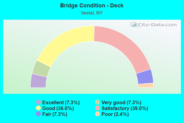
- Bridge Condition - Deck
- 7.3%Excellent
- 7.3%Very good
- 36.6%Good
- 39.0%Satisfactory
- 7.3%Fair
- 2.4%Poor
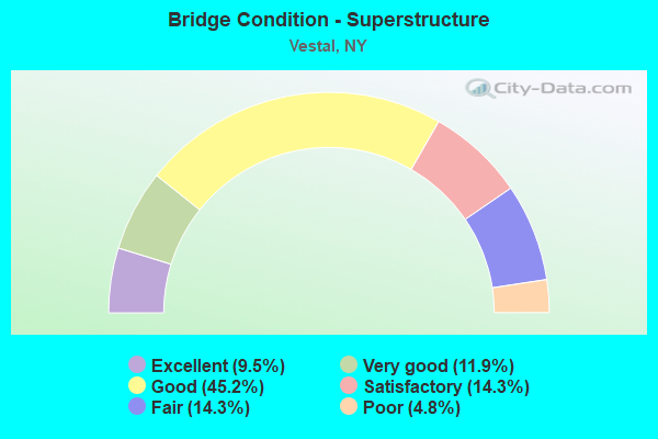
- Bridge Condition - Superstructure
- 9.5%Excellent
- 11.9%Very good
- 45.2%Good
- 14.3%Satisfactory
- 14.3%Fair
- 4.8%Poor
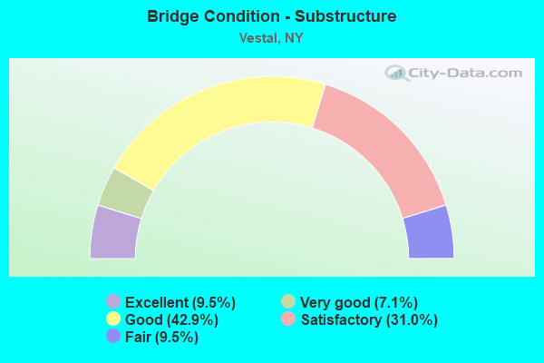
- Bridge Condition - Substructure
- 9.5%Excellent
- 7.1%Very good
- 42.9%Good
- 31.0%Satisfactory
- 9.5%Fair
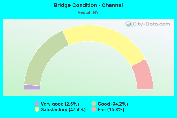
- Bridge Condition - Channel
- 2.6%Very good
- 34.2%Good
- 47.4%Satisfactory
- 15.8%Fair
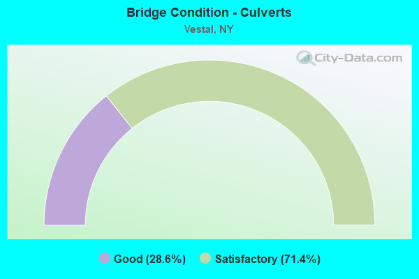
- Bridge Condition - Culverts
- 28.6%Good
- 71.4%Satisfactory
Find on map >> Show street view
Structure Number: 334985, Location: HAMLET OF VESTAL (Lat: 42.091386, Lng: -76.054761), Route carried "on" structure: County highway , Year Built: 1935, Year Reconstructed: 1987, Status: Open, Structure Length: 22.71m (74.51ft), Average Daily Traffic: 12,954 (year 2020), Truck Traffic: 3%, Average Future Daily Traffic: 15,736 (year 2040), Design Load: HS 20, Features Intersected: SUSQUEHANNA RIVER, Facility Carried by Structure: CR 48
Minimum Vertical Clearance: 4.52m (14.83ft), Kilometerpoint: 0.000, Lanes on structure: 2, Owner: County Highway Agency, Approaching Roadway Width: 14.6m (47.9ft), Material/Design: Steel, Design/Construction: Truss - Thru, Number Of Spans In Main Unit: 3, Length of Maximum Span: 74.6m (244.8ft), Curb or Sidewalk Widths: Left: 1.7m (5.6ft), Right: 1.7m (5.6ft), Curb-To-Curb Width: 9.1m (29.9ft), Out-to-Out Width: 10.0m (32.8ft)
Condition: Deck: Satisfactory, Superstructure: Fair, Substructure: Satisfactory, Channel: Good, Operating Rating: 48.1 metric tons, Method Used To Determine Operating Rating: Load Factor (LF), Inventory Rating: 27.2 metric tons, Method Used To Determine Inventory Rating: Load Factor (LF), Structural Evaluation: Somewhat better than minimum adequacy, Deck Geometry: Meets minimum limits, Waterway Adequacy: Somewhat better than minimum adequacy, Approach Roadway Alignment: Better than present minimum criteria, Length Of Structure Improvement: 22.70m (74.48ft), Designated Inspection Frequency: Every 24 months, Critical Feature Inspection Frequency: Every 24 months, Underwater Inspection Frequency: Every 60 months, Inspection Date: November 2020, Critical Feature Inspection Date: November 2020, Underwater Inspection Date: April 2021, Bridge Improvement Cost: $14,332,000, Roadway Improvement Cost: $8,393,000, Total Project Cost: $22,724,000 ( Estimate for 2021), Deck Structure Type: Concrete Cast-file-Place, Wearing Surface/Protective System: Wearing Surface: Integral Concrete, Deck Protection: Epoxy Coated Reinforcing
Find on map >> Show street view
Structure Number: 334986, Location: 2 MI NE OF VESTAL CENTER (Lat: 42.035733, Lng: -76.011875), Route carried "on" structure: County highway , Year Built: 1954, Status: Open, Structure Length: 0.94m (3.08ft), Average Daily Traffic: 860 (year 2020), Truck Traffic: 5%, Average Future Daily Traffic: 1,064 (year 2040), Design Load: H 20, Features Intersected: SUGAR CREEK, Facility Carried by Structure: POWDERHOUSE ROAD
Minimum Vertical Clearance: 30+ m (98+ ft), Kilometerpoint: 0.434, Lanes on structure: 2, Owner: County Highway Agency, Approaching Roadway Width: 9.8m (32.2ft), Skew: 3 degrees, Material/Design: Concrete, Design/Construction: Slab, Number Of Spans In Main Unit: 1, Length of Maximum Span: 8.8m (28.9ft), Curb or Sidewalk Widths: Left: 2.2m (7.2ft), Right: 0.0m, Curb-To-Curb Width: 7.9m (25.9ft), Out-to-Out Width: 10.7m (35.1ft)
Condition: Deck: Good, Superstructure: Good, Substructure: Satisfactory, Channel: Good, Operating Rating: 67.2 metric tons, Method Used To Determine Operating Rating: Field evaluation and documented engineering judgment, Inventory Rating: 28.9 metric tons, Method Used To Determine Inventory Rating: Field evaluation and documented engineering judgment, Structural Evaluation: Equal to present minimum criteria, Deck Geometry: Somewhat better than minimum adequacy, Waterway Adequacy: Equal to present desirable criteria, Approach Roadway Alignment: Equal to present desirable criteria, Length Of Structure Improvement: 0.94m (3.08ft), Designated Inspection Frequency: Every 24 months, Inspection Date: April 2020, Bridge Improvement Cost: $512,000, Roadway Improvement Cost: $300,000, Total Project Cost: $811,000 ( Estimate for 2021), Wearing Surface/Protective System: Wearing Surface: Bituminous
Find on map >> Show street view
Structure Number: 334987, Location: 1.5 MI NE OF VESTAL CENTR (Lat: 42.038511, Lng: -76.005100), Route carried "on" structure: County highway , Year Built: 1984, Status: Open, Structure Length: 1.04m (3.41ft), Average Daily Traffic: 860 (year 2020), Truck Traffic: 5%, Average Future Daily Traffic: 1,064 (year 2040), Features Intersected: SUGAR CREEK, Facility Carried by Structure: POWDERHOUSE ROAD
Minimum Vertical Clearance: 30+ m (98+ ft), Kilometerpoint: 1.094, Lanes on structure: 2, Owner: County Highway Agency, Approaching Roadway Width: 10.7m (35.1ft), Skew: 1 degrees, Material/Design: Wood or Timber, Design/Construction: Slab, Number Of Spans In Main Unit: 1, Length of Maximum Span: 10.0m (32.8ft), Curb-To-Curb Width: 10.6m (34.8ft), Out-to-Out Width: 11.1m (36.4ft)
Condition: Deck: Good, Superstructure: Good, Substructure: Good, Channel: Fair, Operating Rating: 49.9 metric tons, Method Used To Determine Operating Rating: Allowable Stress (AS), Inventory Rating: 30.8 metric tons, Method Used To Determine Inventory Rating: Allowable Stress (AS), Structural Evaluation: Better than present minimum criteria, Deck Geometry: Equal to present minimum criteria, Waterway Adequacy: Equal to present desirable criteria, Approach Roadway Alignment: Equal to present desirable criteria, Length Of Structure Improvement: 1.03m (3.38ft), Designated Inspection Frequency: Every 24 months, Inspection Date: April 2020, Bridge Improvement Cost: $436,000, Roadway Improvement Cost: $255,000, Total Project Cost: $691,000 ( Estimate for 2021), Wearing Surface/Protective System: Wearing Surface: Bituminous
Find on map >> Show street view
Structure Number: 334988, Location: .9 MI NE OF VESTAL CENTER (Lat: 42.039967, Lng: -76.001225), Route carried "on" structure: County highway , Year Built: 1982, Status: Open, Structure Length: 1.01m (3.31ft), Average Daily Traffic: 860 (year 2020), Truck Traffic: 5%, Average Future Daily Traffic: 1,064 (year 2040), Design Load: HS 20, Features Intersected: SUGAR CREEK, Facility Carried by Structure: POWDERHOUSE ROAD
Minimum Vertical Clearance: 30+ m (98+ ft), Kilometerpoint: 0.740, Lanes on structure: 2, Owner: County Highway Agency, Approaching Roadway Width: 10.4m (34.1ft), Skew: 4 degrees, Material/Design: Wood or Timber, Design/Construction: Slab, Number Of Spans In Main Unit: 1, Length of Maximum Span: 7.0m (23.0ft), Curb-To-Curb Width: 10.9m (35.8ft), Out-to-Out Width: 11.2m (36.7ft)
Condition: Deck: Very good, Superstructure: Very good, Substructure: Good, Channel: Good, Operating Rating: 54.4 metric tons, Method Used To Determine Operating Rating: Allowable Stress (AS), Inventory Rating: 37.2 metric tons, Method Used To Determine Inventory Rating: Allowable Stress (AS), Structural Evaluation: Better than present minimum criteria, Deck Geometry: Equal to present minimum criteria, Waterway Adequacy: Equal to present desirable criteria, Approach Roadway Alignment: Equal to present desirable criteria, Length Of Structure Improvement: 1.00m (3.28ft), Designated Inspection Frequency: Every 24 months, Inspection Date: April 2020, Bridge Improvement Cost: $546,000, Roadway Improvement Cost: $320,000, Total Project Cost: $866,000 ( Estimate for 2021), Wearing Surface/Protective System: Wearing Surface: Bituminous
Find on map >> Show street view
Structure Number: 334989, Location: 1.2 MI NE OF VESTAL CENTR (Lat: 42.042411, Lng: -75.996608), Route carried "on" structure: County highway , Year Built: 1982, Status: Open, Structure Length: 0.79m (2.59ft), Average Daily Traffic: 860 (year 2020), Truck Traffic: 5%, Average Future Daily Traffic: 1,064 (year 2040), Design Load: HS 20, Features Intersected: SUGAR CREEK, Facility Carried by Structure: POWDERHOUSE ROAD
Minimum Vertical Clearance: 30+ m (98+ ft), Kilometerpoint: 1.915, Lanes on structure: 2, Owner: County Highway Agency, Approaching Roadway Width: 10.4m (34.1ft), Skew: 2 degrees, Material/Design: Wood or Timber, Design/Construction: Slab, Number Of Spans In Main Unit: 1, Length of Maximum Span: 7.0m (23.0ft), Curb-To-Curb Width: 10.9m (35.8ft), Out-to-Out Width: 11.2m (36.7ft)
Condition: Deck: Good, Superstructure: Good, Substructure: Satisfactory, Channel: Satisfactory, Operating Rating: 53.5 metric tons, Method Used To Determine Operating Rating: Allowable Stress (AS), Inventory Rating: 37.2 metric tons, Method Used To Determine Inventory Rating: Allowable Stress (AS), Structural Evaluation: Equal to present minimum criteria, Deck Geometry: Equal to present minimum criteria, Waterway Adequacy: Equal to present desirable criteria, Approach Roadway Alignment: Equal to present desirable criteria, Length Of Structure Improvement: 0.79m (2.59ft), Designated Inspection Frequency: Every 24 months, Inspection Date: April 2020, Bridge Improvement Cost: $427,000, Roadway Improvement Cost: $250,000, Total Project Cost: $676,000 ( Estimate for 2021), Wearing Surface/Protective System: Wearing Surface: Bituminous
Find on map >> Show street view
Structure Number: 33499, Location: 4 MILES SW OF VESTAL (Lat: 42.040483, Lng: -76.083053), Route carried "on" structure: County highway , Year Built: 1952, Status: Open, Structure Length: 0.76m (2.49ft), Average Daily Traffic: 1,042 (year 2020), Truck Traffic: 5%, Average Future Daily Traffic: 1,289 (year 2040), Features Intersected: TRIB TRACY CREEK, Facility Carried by Structure: TRACY CREEK ROAD
Minimum Vertical Clearance: 30+ m (98+ ft), Kilometerpoint: 2.301, Lanes on structure: 2, Owner: County Highway Agency, Approaching Roadway Width: 8.2m (26.9ft), Material/Design: Concrete, Design/Construction: Slab, Number Of Spans In Main Unit: 1, Length of Maximum Span: 7.3m (24.0ft), Curb-To-Curb Width: 7.0m (23.0ft), Out-to-Out Width: 7.9m (25.9ft)
Condition: Deck: Good, Superstructure: Good, Substructure: Satisfactory, Channel: Good, Operating Rating: 53.5 metric tons, Method Used To Determine Operating Rating: Load Factor (LF), Inventory Rating: 31.8 metric tons, Method Used To Determine Inventory Rating: Load Factor (LF), Structural Evaluation: Equal to present minimum criteria, Deck Geometry: High priority of corrective action, Waterway Adequacy: Meets minimum limits, Approach Roadway Alignment: Equal to present minimum criteria, Length Of Structure Improvement: 0.76m (2.49ft), Designated Inspection Frequency: Every 24 months, Inspection Date: June 2020, Bridge Improvement Cost: $302,000, Roadway Improvement Cost: $177,000, Total Project Cost: $479,000 ( Estimate for 2021), Wearing Surface/Protective System: Wearing Surface: Bituminous
Find on map >> Show street view
Structure Number: 334991, Location: .5 MILE S OF JOHNSON CITY (Lat: 42.096844, Lng: -75.965339), Route carried "on" structure: County highway , Year Built: 1962, Status: Open, Structure Length: 0.85m (2.79ft), Average Daily Traffic: 2,865 (year 2020), Truck Traffic: 8%, Average Future Daily Traffic: 3,480 (year 2040), Design Load: H 20, Features Intersected: FULLER HOLLOW CRK, Facility Carried by Structure: OLD VESTAL ROAD
Minimum Vertical Clearance: 30+ m (98+ ft), Kilometerpoint: 8.302, Lanes on structure: 2, Owner: County Highway Agency, Approaching Roadway Width: 11.0m (36.1ft), Material/Design: Concrete, Design/Construction: Slab, Number Of Spans In Main Unit: 1, Length of Maximum Span: 7.9m (25.9ft), Curb or Sidewalk Widths: Left: 1.6m (5.2ft), Right: 0.0m, Curb-To-Curb Width: 11.0m (36.1ft), Out-to-Out Width: 13.5m (44.3ft)
Condition: Deck: Satisfactory, Superstructure: Satisfactory, Substructure: Good, Channel: Satisfactory, Operating Rating: 70.5 metric tons, Method Used To Determine Operating Rating: Field evaluation and documented engineering judgment, Inventory Rating: 30.6 metric tons, Method Used To Determine Inventory Rating: Field evaluation and documented engineering judgment, Structural Evaluation: Equal to present minimum criteria, Deck Geometry: Somewhat better than minimum adequacy, Waterway Adequacy: Equal to present desirable criteria, Approach Roadway Alignment: Equal to present desirable criteria, Length Of Structure Improvement: 0.85m (2.79ft), Designated Inspection Frequency: Every 24 months, Inspection Date: June 2020, Bridge Improvement Cost: $444,000, Roadway Improvement Cost: $260,000, Total Project Cost: $703,000 ( Estimate for 2021), Wearing Surface/Protective System: Wearing Surface: Bituminous
Find on map >> Show street view
Structure Number: 334992, Location: 1.5 MI SE VESTAL CENTER (Lat: 42.013200, Lng: -76.006789), Route carried "on" structure: County highway , Year Built: 1935, Status: Open, Structure Length: 1.46m (4.79ft), Average Daily Traffic: 416 (year 2017), Truck Traffic: 4%, Average Future Daily Traffic: 514 (year 2040), Features Intersected: BIG CHOCONUT CREEK, Facility Carried by Structure: GLENWOOD ROAD
Minimum Vertical Clearance: 30+ m (98+ ft), Kilometerpoint: 0.241, Lanes on structure: 2, Owner: County Highway Agency, Approaching Roadway Width: 5.5m (18.0ft), Material/Design: Steel, Design/Construction: Stringer/Multi-beam, Number Of Spans In Main Unit: 1, Length of Maximum Span: 14.0m (45.9ft), Curb-To-Curb Width: 6.1m (20.0ft), Out-to-Out Width: 6.8m (22.3ft)
Condition: Deck: Satisfactory, Superstructure: Poor, Substructure: Satisfactory, Channel: Fair, Operating Rating: 39.0 metric tons, Method Used To Determine Operating Rating: Load Factor (LF), Inventory Rating: 22.7 metric tons, Method Used To Determine Inventory Rating: Load Factor (LF), Structural Evaluation: Meets minimum limits, Deck Geometry: High priority of corrective action, Waterway Adequacy: Meets minimum limits, Approach Roadway Alignment: Somewhat better than minimum adequacy, Length Of Structure Improvement: 1.46m (4.79ft), Designated Inspection Frequency: Every 24 months, Inspection Date: June 2020, Bridge Improvement Cost: $386,000, Roadway Improvement Cost: $226,000, Total Project Cost: $612,000 ( Estimate for 2021), Deck Structure Type: Concrete Cast-file-Place, Wearing Surface/Protective System: Wearing Surface: Bituminous, Membrane: Other
Find on map >> Show street view
Structure Number: 334993, Location: .5 MI SW OF VESTAL CENTER (Lat: 42.031078, Lng: -76.017828), Route carried "on" structure: Other road , Year Built: 1945, Status: Open, Structure Length: 2.68m (8.79ft), Average Daily Traffic: 889 (year 2016), Truck Traffic: 4%, Average Future Daily Traffic: 1,245 (year 2036), Features Intersected: BIG CHOCONUT CRK, Facility Carried by Structure: WEST HILL ROAD
Minimum Vertical Clearance: 30+ m (98+ ft), Kilometerpoint: 3.427, Lanes on structure: 2, Owner: County Highway Agency, Approaching Roadway Width: 6.1m (20.0ft), Skew: 3 degrees, Material/Design: Steel, Design/Construction: Stringer/Multi-beam, Number Of Spans In Main Unit: 3, Length of Maximum Span: 13.4m (44.0ft), Curb or Sidewalk Widths: Left: 0.0m, Right: 1.2m (3.9ft), Curb-To-Curb Width: 7.4m (24.3ft), Out-to-Out Width: 9.5m (31.2ft)
Condition: Deck: Good, Superstructure: Good, Substructure: Good, Channel: Satisfactory, Operating Rating: 47.2 metric tons, Method Used To Determine Operating Rating: Load Factor (LF), Inventory Rating: 28.1 metric tons, Method Used To Determine Inventory Rating: Load Factor (LF), Structural Evaluation: Better than present minimum criteria, Deck Geometry: Meets minimum limits, Waterway Adequacy: Meets minimum limits, Approach Roadway Alignment: Equal to present desirable criteria, Length Of Structure Improvement: 2.68m (8.79ft), Designated Inspection Frequency: Every 24 months, Inspection Date: May 2021, Bridge Improvement Cost: $796,000, Roadway Improvement Cost: $466,000, Total Project Cost: $1,262,000 ( Estimate for 2021), Deck Structure Type: Concrete Cast-file-Place, Wearing Surface/Protective System: Wearing Surface: Monolithic Concrete
Find on map >> Show street view
Structure Number: 334994, Location: .5 MI W VESTAL CENTER (Lat: 42.052539, Lng: -76.035272), Route carried "on" structure: Other road , Year Built: 2019, Status: Open, Structure Length: 3.38m (11.09ft), Average Daily Traffic: 1,389 (year 2016), Truck Traffic: 5%, Average Future Daily Traffic: 1,718 (year 2040), Design Load: HL 93, Features Intersected: BIG CHOCONUT CR, Facility Carried by Structure: JUNEBERRY ROAD
Minimum Vertical Clearance: 30+ m (98+ ft), Kilometerpoint: 0.193, Lanes on structure: 2, Owner: County Highway Agency, Approaching Roadway Width: 7.9m (25.9ft), Material/Design: Prestressed concrete, Design/Construction: Box Beam or Girders - Multiple, Number Of Spans In Main Unit: 1, Length of Maximum Span: 32.9m (107.9ft), Curb or Sidewalk Widths: Left: 1.8m (5.9ft), Right: 0.0m, Curb-To-Curb Width: 7.9m (25.9ft), Out-to-Out Width: 10.8m (35.4ft)
Condition: Deck: Excellent, Superstructure: Excellent, Substructure: Excellent, Channel: Good, Inventory Rating: 48.1 metric tons, Method Used To Determine Inventory Rating: Load Factor (LF), Structural Evaluation: Superior to present desirable criteria, Deck Geometry: Meets minimum limits, Waterway Adequacy: Meets minimum limits, Approach Roadway Alignment: Meets minimum limits, Length Of Structure Improvement: 3.38m (11.09ft), Designated Inspection Frequency: Every 24 months, Inspection Date: November 2021, Bridge Improvement Cost: $902,000, Roadway Improvement Cost: $528,000, Total Project Cost: $1,431,000 ( Estimate for 2021), Deck Structure Type: Concrete Cast-file-Place, Wearing Surface/Protective System: Wearing Surface: Integral Concrete, Deck Protection: Epoxy Coated Reinforcing
Find on map >> Show street view
Structure Number: 335007, Location: OLD VESTAL ROAD CR311 (Lat: 42.097872, Lng: -75.969472), Route carried "on" structure: Alternate County highway , Year Built: 1982, Status: Open, Structure Length: 0.79m (2.59ft), Average Daily Traffic: 2,865 (year 2020), Truck Traffic: 8%, Average Future Daily Traffic: 3,480 (year 2040), Features Intersected: BUNN HILL CREEK, Facility Carried by Structure: CR44 OLD VESTAL RD
Minimum Vertical Clearance: 30+ m (98+ ft), Kilometerpoint: 7.707, Lanes on structure: 2, Owner: County Highway Agency, Approaching Roadway Width: 10.1m (33.1ft), Material/Design: Steel, Design/Construction: Culvert, Number Of Spans In Main Unit: 2, Length of Maximum Span: 3.6m (11.8ft), Curb or Sidewalk Widths: Left: 1.5m (4.9ft), Right: 0.0m
Condition: Channel: Fair, Culverts: Satisfactory, Operating Rating: 75.1 metric tons, Method Used To Determine Operating Rating: Field evaluation and documented engineering judgment, Inventory Rating: 32.7 metric tons, Method Used To Determine Inventory Rating: Field evaluation and documented engineering judgment, Structural Evaluation: Equal to present minimum criteria, Waterway Adequacy: Equal to present desirable criteria, Approach Roadway Alignment: Equal to present desirable criteria, Length Of Structure Improvement: 0.79m (2.59ft), Designated Inspection Frequency: Every 24 months, Inspection Date: April 2020, Bridge Improvement Cost: $141,000, Roadway Improvement Cost: $83,000, Total Project Cost: $224,000 ( Estimate for 2021)
Find on map >> Show street view
Structure Number: 336825, Location: 2.2 MI NE OF VESTAL CNTR (Lat: 42.050286, Lng: -75.976961), Route carried "on" structure: County highway , Year Built: 1979, Status: Open, Structure Length: 0.73m (2.40ft), Average Daily Traffic: 660 (year 2020), Truck Traffic: 5%, Average Future Daily Traffic: 816 (year 2040), Features Intersected: SUGAR CREEK, Facility Carried by Structure: POWDERHOUSE ROAD
Minimum Vertical Clearance: 30+ m (98+ ft), Kilometerpoint: 3.878, Lanes on structure: 2, Owner: County Highway Agency, Approaching Roadway Width: 7.3m (24.0ft), Skew: 4 degrees, Material/Design: Aluminum, Iron, Design/Construction: Culvert, Number Of Spans In Main Unit: 1, Length of Maximum Span: 7.0m (23.0ft)
Condition: Channel: Satisfactory, Culverts: Good, Operating Rating: 77.6 metric tons, Method Used To Determine Operating Rating: Field evaluation and documented engineering judgment, Inventory Rating: 32.7 metric tons, Method Used To Determine Inventory Rating: Field evaluation and documented engineering judgment, Structural Evaluation: Better than present minimum criteria, Waterway Adequacy: Somewhat better than minimum adequacy, Approach Roadway Alignment: Equal to present desirable criteria, Length Of Structure Improvement: 0.73m (2.40ft), Designated Inspection Frequency: Every 24 months, Inspection Date: March 2021, Bridge Improvement Cost: $95,000, Roadway Improvement Cost: $55,000, Total Project Cost: $150,000 ( Estimate for 2021)
Find on map >> Show street view
Structure Number: 1012999, Location: JCT RTS 26 + 434 (Lat: 42.089181, Lng: -76.042708), Route carried "under" structure: State highway 434, Year Built: 1964, Structure Length: 0. m, Average Daily Traffic: 25,000 (year 1980), Features Intersected: 434 434 91011038 W, RTE, Facility Carried by Structure: RTE 26
Minimum Vertical Clearance: 4.47m (14.67ft), Kilometerpoint: 6.034, Lanes on structure: 6, Lanes under structure: 3, Material/Design: Steel, Design/Construction: Stringer/Multi-beam, Length of Maximum Span: 19.5m (64.0ft)
Find on map >> Show street view
Structure Number: 1013009, Location: JCT SH 201 & SH 434 (Lat: 42.095675, Lng: -75.971486), Route carried "under" structure: State highway 434, Year Built: 2011, Structure Length: 0. m, Average Daily Traffic: 20,800 (year 1981), Features Intersected: 434 434 91011077EB, RTE, Facility Carried by Structure: RTE 201
Minimum Vertical Clearance: 4.78m (15.68ft), Kilometerpoint: 12.035, Lanes on structure: 2, Lanes under structure: 3, Material/Design: Steel, Design/Construction: Stringer/Multi-beam, Length of Maximum Span: 34.1m (111.9ft)
Find on map >> Show street view
Structure Number: 1014349, Location: 0.2 MI N JCT RTS 201+434 (Lat: 42.097928, Lng: -75.971364), Route carried "under" structure: Bypass County highway , Year Built: 2011, Structure Length: 0. m, Average Daily Traffic: 13,070 (year 1981), Features Intersected: OLD VESTAL ROAD, Facility Carried by Structure: RTE 201
Minimum Vertical Clearance: 4.83m (15.85ft), Kilometerpoint: 0.000, Lanes on structure: 4, Lanes under structure: 2, Material/Design: Steel, Design/Construction: Stringer/Multi-beam, Length of Maximum Span: 25.6m (84.0ft)
Find on map >> Show street view
Structure Number: 1018431, Location: JCT SH 26 & SUSQUEHANNA R (Lat: 42.094569, Lng: -76.043856), Route carried "under" structure: Bypass County highway , Year Built: 1964, Structure Length: 0. m, Features Intersected: CR 44 - OLD VESTAL RD, S, Facility Carried by Structure: RTE 26
Minimum Vertical Clearance: 5.30m (17.39ft), Kilometerpoint: 0.000, Lanes on structure: 3, Lanes under structure: 2, Material/Design: Steel continuous, Design/Construction: Stringer/Multi-beam, Length of Maximum Span: 68.6m (225.1ft)
Find on map >> Show street view
Structure Number: 1018432, Location: JCT SH 26 & SUSQUEHANNA R (Lat: 42.094922, Lng: -76.043769), Route carried "under" structure: Bypass County highway , Year Built: 1964, Structure Length: 0. m, Features Intersected: CR 44 - OLD VESTAL ROAD,, Facility Carried by Structure: RTE 26
Minimum Vertical Clearance: 5.23m (17.16ft), Kilometerpoint: 0.000, Lanes on structure: 3, Lanes under structure: 2, Material/Design: Steel continuous, Design/Construction: Stringer/Multi-beam, Length of Maximum Span: 68.6m (225.1ft)
Find on map >> Show street view
Structure Number: 1054781, Location: 2.0 MI W JCT RTS 17 + 26 (Lat: 42.079231, Lng: -76.077783), Route carried "under" structure: Spur County highway , Year Built: 1969, Structure Length: 0. m, Features Intersected: CASTLE GARDENS RD, Facility Carried by Structure: RTE 17
Minimum Vertical Clearance: 4.36m (14.30ft), Kilometerpoint: 0.000, Lanes on structure: 2, Lanes under structure: 2, Material/Design: Steel, Design/Construction: Stringer/Multi-beam, Length of Maximum Span: 13.7m (44.9ft)
Find on map >> Show street view
Structure Number: 1054782, Location: 2.0 MI W JCT RTS 17 + 26 (Lat: 42.078981, Lng: -76.077617), Route carried "under" structure: Spur County highway , Year Built: 1969, Structure Length: 0. m, Features Intersected: CASTLE GARDENS RD, Facility Carried by Structure: RTE 17
Minimum Vertical Clearance: 4.39m (14.40ft), Kilometerpoint: 1.014, Lanes on structure: 2, Lanes under structure: 2, Material/Design: Steel, Design/Construction: Stringer/Multi-beam, Length of Maximum Span: 13.7m (44.9ft)
Find on map >> Show street view
Structure Number: 1054801, Location: 0.6 MI W JCT RTS 17 + 26 (Lat: 42.088475, Lng: -76.053733), Route carried "under" structure: Spur Other road , Year Built: 1969, Structure Length: 0. m, Average Daily Traffic: 14,215 (year 2013), Truck Traffic: 6%, Features Intersected: NORTH MAIN STREET, Facility Carried by Structure: RTE 17
Minimum Vertical Clearance: 4.85m (15.91ft), Kilometerpoint: 0.000, Lanes on structure: 2, Lanes under structure: 3, Material/Design: Steel, Design/Construction: Stringer/Multi-beam, Length of Maximum Span: 25.6m (84.0ft)
Find on map >> Show street view
Structure Number: 1054802, Location: 0.6 MI W JCT RTS 17 + 26 (Lat: 42.088253, Lng: -76.053753), Route carried "under" structure: Spur Other road , Year Built: 1969, Structure Length: 0. m, Average Daily Traffic: 6,312 (year 2018), Truck Traffic: 3%, Features Intersected: NORTH MAIN STREET, Facility Carried by Structure: RTE 17
Minimum Vertical Clearance: 4.62m (15.16ft), Kilometerpoint: 0.209, Lanes on structure: 2, Lanes under structure: 3, Material/Design: Steel, Design/Construction: Stringer/Multi-beam, Length of Maximum Span: 25.6m (84.0ft)
Find on map >> Show street view
Structure Number: 1054811, Location: JCT SH 17 & SH 26 (Lat: 42.091975, Lng: -76.043450), Route carried "under" structure: State highway 17, Year Built: 1994, Structure Length: 0. m, Average Daily Traffic: 15,800 (year 1972), Features Intersected: 17 17 91071038 WB, RTE 1, Facility Carried by Structure: RTE 26
Minimum Vertical Clearance: 5.21m (17.09ft), Kilometerpoint: 6.114, Lanes on structure: 3, Lanes under structure: 3, Material/Design: Steel continuous, Design/Construction: Stringer/Multi-beam, Length of Maximum Span: 32.6m (107.0ft)
Find on map >> Show street view
Structure Number: 1054812, Location: JCT SH 17 & SH 26 (Lat: 42.091844, Lng: -76.043303), Route carried "under" structure: State highway 17, Year Built: 1994, Structure Length: 0. m, Average Daily Traffic: 15,800 (year 1972), Features Intersected: 17 17 91071038, RTE 17, Facility Carried by Structure: RTE 26
Minimum Vertical Clearance: 5.13m (16.83ft), Kilometerpoint: 6.114, Lanes on structure: 3, Lanes under structure: 3, Material/Design: Steel continuous, Design/Construction: Stringer/Multi-beam, Length of Maximum Span: 32.6m (107.0ft)
Find on map >> Show street view
Structure Number: 1054821, Location: 0.8 MI E JCT RTS 17 + 26 (Lat: 42.097106, Lng: -76.030697), Route carried "under" structure: Alternate County highway , Year Built: 1969, Structure Length: 0. m, Average Daily Traffic: 5,054 (year 2019), Truck Traffic: 7%, Features Intersected: CR 44 - Old Vestal Road, Facility Carried by Structure: RTE 17
Minimum Vertical Clearance: 4.31m (14.14ft), Kilometerpoint: 3.492, Lanes on structure: 2, Lanes under structure: 2, Material/Design: Steel, Design/Construction: Stringer/Multi-beam, Length of Maximum Span: 26.5m (86.9ft)
Find on map >> Show street view
Structure Number: 1054822, Location: .8 MI E JCT SH 17 & SH 26 (Lat: 42.097131, Lng: -76.030336), Route carried "under" structure: Alternate County highway , Year Built: 1969, Structure Length: 0. m, Average Daily Traffic: 5,054 (year 2019), Truck Traffic: 7%, Features Intersected: CR 44 - Old Vestal Road, Facility Carried by Structure: RTE 17
Minimum Vertical Clearance: 4.60m (15.09ft), Kilometerpoint: 4.006, Lanes on structure: 2, Lanes under structure: 2, Material/Design: Steel, Design/Construction: Stringer/Multi-beam, Length of Maximum Span: 23.4m (76.8ft)