Bridge Statistics for Vallejo, California (CA)
Condition, Traffic, Stress, Structural Evaluation, Project Costs
- National Bridge Inventory (NBI) Statistics
- 92Number of bridges
- 2,753ft / 839mTotal length
- $41,537,000Total costs
- 3,707,556Total average daily traffic
- 234,750Total average daily truck traffic
- National Bridge Inventory (NBI) Registered Bridges for Vallejo
- No street view available for this location
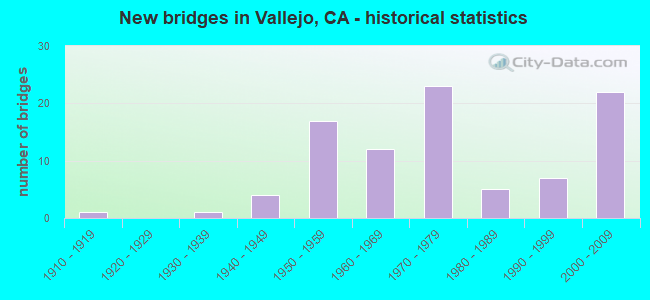
- New bridges - historical statistics
- 11910-1919
- 11930-1939
- 41940-1949
- 171950-1959
- 121960-1969
- 231970-1979
- 51980-1989
- 71990-1999
- 222000-2009
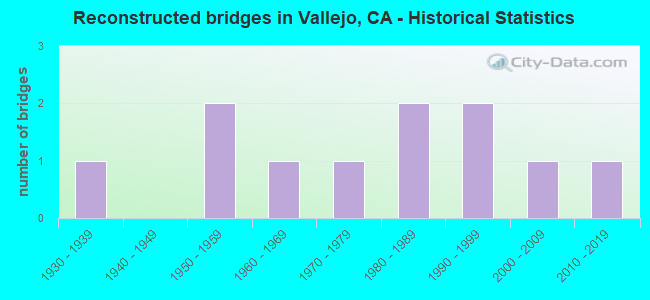
- Reconstructed bridges - Historical Statistics
- 11930-1939
- 01940-1949
- 21950-1959
- 11960-1969
- 11970-1979
- 21980-1989
- 21990-1999
- 12000-2009
- 12010-2019
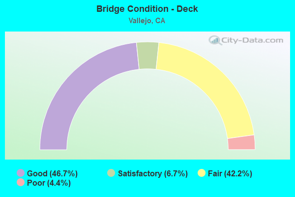
- Bridge Condition - Deck
- 46.7%Good
- 6.7%Satisfactory
- 42.2%Fair
- 4.4%Poor
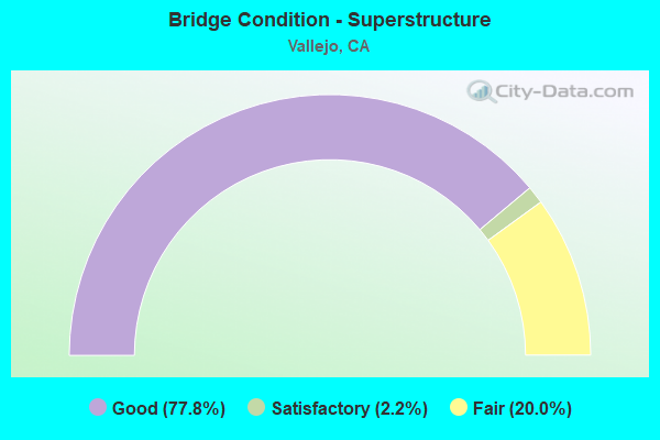
- Bridge Condition - Superstructure
- 77.8%Good
- 2.2%Satisfactory
- 20.0%Fair
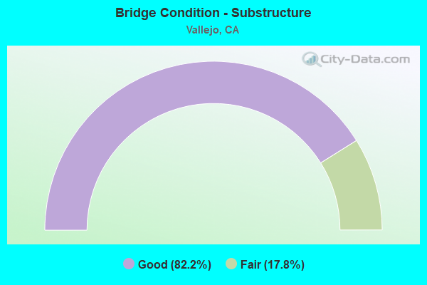
- Bridge Condition - Substructure
- 82.2%Good
- 17.8%Fair
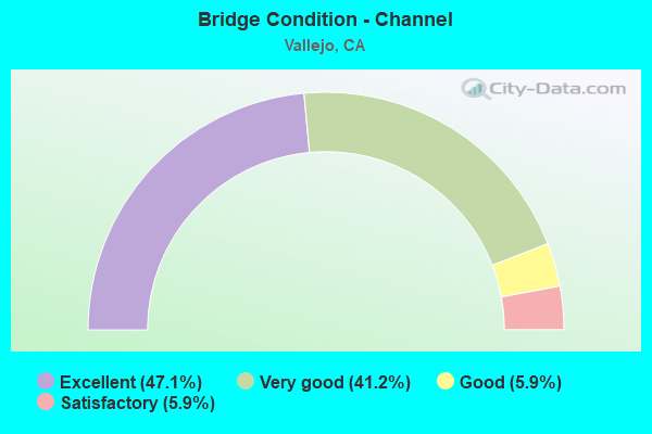
- Bridge Condition - Channel
- 47.1%Excellent
- 41.2%Very good
- 5.9%Good
- 5.9%Satisfactory
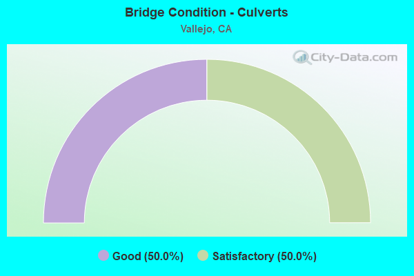
- Bridge Condition - Culverts
- 50.0%Good
- 50.0%Satisfactory
Find on map >> Show street view
Structure Number: 23C0152, Location: BTWN ILLINOIS FARRAGUT ST (Lat: 38.112061, Lng: -122.257897), Route carried "on" structure: City street , Year Built: 1913, Year Reconstructed: 1930, Status: Open, Structure Length: 3.44m (11.29ft), Average Daily Traffic: 8,792 (year 2008), Truck Traffic: 4%, Average Future Daily Traffic: 13,529 (year 2042), Features Intersected: US NAVY RR, Facility Carried by Structure: SACRAMENTO ST
Minimum Vertical Clearance: 30+ m (98+ ft), Kilometerpoint: 0.000, Lanes on structure: 4, Base Highway Network: Yes, Owner: City or Municipal Highway Agency, Approaching Roadway Width: 15.8m (51.8ft), Skew: 4 degrees, Material/Design: Steel continuous, Design/Construction: Stringer/Multi-beam, Number Of Spans In Main Unit: 4, Length of Maximum Span: 11.6m (38.1ft), Curb or Sidewalk Widths: Left: 1.5m (4.9ft), Right: 1.5m (4.9ft), Curb-To-Curb Width: 15.8m (51.8ft), Out-to-Out Width: 19.0m (62.3ft)
Condition: Deck: Good, Superstructure: Good, Substructure: Fair, Operating Rating: 25.3 metric tons, Method Used To Determine Operating Rating: Field evaluation and documented engineering judgment, Inventory Rating: 15.2 metric tons, Method Used To Determine Inventory Rating: Field evaluation and documented engineering judgment, Structural Evaluation: High priority of corrective action, Deck Geometry: Meets minimum limits, Underclear: Meets minimum limits, Approach Roadway Alignment: Equal to present desirable criteria, Designated Inspection Frequency: Every 24 months, Inspection Date: March 2022, Deck Structure Type: Concrete Cast-file-Place, Wearing Surface/Protective System: Wearing Surface: Bituminous
Find on map >> Show street view
Structure Number: 23C024, Location: 0.5 MI E OF SUNSET AVE (Lat: 38.253128, Lng: -122.009706), Route carried "on" structure: City street , Year Built: 1991, Status: Open, Structure Length: 2.49m (8.17ft), Average Daily Traffic: 1,500 (year 2010), Truck Traffic: 1%, Average Future Daily Traffic: 3,294 (year 2043), Features Intersected: LAUREL CREEK DIVERSION, Facility Carried by Structure: WORLEY RD
Minimum Vertical Clearance: 30+ m (98+ ft), Kilometerpoint: 0.000, Lanes on structure: 2, Owner: City or Municipal Highway Agency, Approaching Roadway Width: 12.5m (41.0ft), Material/Design: Concrete continuous, Design/Construction: Culvert, Number Of Spans In Main Unit: 6, Length of Maximum Span: 3.9m (12.8ft), Curb or Sidewalk Widths: Left: 2.0m (6.6ft), Right: 2.0m (6.6ft), Curb-To-Curb Width: 12.5m (41.0ft), Out-to-Out Width: 17.0m (55.8ft)
Condition: Channel: Good, Culverts: Good, Operating Rating: 54.1 metric tons, Method Used To Determine Operating Rating: Field evaluation and documented engineering judgment, Inventory Rating: 32.4 metric tons, Method Used To Determine Inventory Rating: Field evaluation and documented engineering judgment, Structural Evaluation: Better than present minimum criteria, Deck Geometry: Better than present minimum criteria, Waterway Adequacy: Superior to present desirable criteria, Approach Roadway Alignment: Equal to present desirable criteria, Designated Inspection Frequency: Every 48 months, Inspection Date: November 2021, Deck Structure Type: Concrete Cast-file-Place, Wearing Surface/Protective System: Wearing Surface: Bituminous
Find on map >> Show street view
Structure Number: 23C0248, Location: 1 MILE WEST OF SR 29 (Lat: 38.109639, Lng: -122.277600), Route carried "on" structure: City street , Year Built: 1934, Year Reconstructed: 1980, Status: Open, Structure Length: 61.13m (200.56ft), Average Daily Traffic: 5,743 (year 2008), Truck Traffic: 10%, Average Future Daily Traffic: 10,408 (year 2042), Features Intersected: NAPA RIVER, Facility Carried by Structure: G STREET
Minimum Vertical Clearance: 30+ m (98+ ft), Kilometerpoint: 0.000, Lanes on structure: 2, Owner: City or Municipal Highway Agency, Approaching Roadway Width: 9.0m (29.5ft), Navigation Control: Yes ( Vertical Clearance: 30.5m (100.1ft), Horizontal Clearance: 42.7m (140.1ft)), Material/Design: Steel, Design/Construction: Movable - Lift, Number Of Spans In Main Unit: 1, Number Of Approach Spans: 51, Length of Maximum Span: 50.3m (165.0ft), Curb or Sidewalk Widths: Left: 0.0m, Right: 2.4m (7.9ft), Curb-To-Curb Width: 9.1m (29.9ft), Out-to-Out Width: 11.5m (37.7ft)
Condition: Deck: Fair, Superstructure: Fair, Substructure: Fair, Channel: Very good, Operating Rating: 53.5 metric tons, Method Used To Determine Operating Rating: Load Factor (LF), Inventory Rating: 32.1 metric tons, Method Used To Determine Inventory Rating: Load Factor (LF), Structural Evaluation: Somewhat better than minimum adequacy, Deck Geometry: Meets minimum limits, Waterway Adequacy: Equal to present desirable criteria, Approach Roadway Alignment: Equal to present desirable criteria, Designated Inspection Frequency: Every 24 months, Critical Feature Inspection Frequency: Every 24 months, Underwater Inspection Frequency: Every 60 months, Inspection Date: March 2022, Critical Feature Inspection Date: October 2020, Underwater Inspection Date: April 2021, Deck Structure Type: Open Grating
Find on map >> Show street view
Structure Number: 23C025, Location: 0.15 MI S OF MANKAS CORNR (Lat: 38.269756, Lng: -122.092536), Route carried "on" structure: County highway , Year Built: 2009, Status: Open, Structure Length: 1.30m (4.27ft), Average Daily Traffic: 3,150 (year 2002), Truck Traffic: 5%, Average Future Daily Traffic: 5,084 (year 2037), Design Load: HS 20+Mod, Features Intersected: LEDGEWOOD CREEK, Facility Carried by Structure: ABERNATHY ROAD
Minimum Vertical Clearance: 30+ m (98+ ft), Kilometerpoint: 0.000, Lanes on structure: 2, Owner: County Highway Agency, Approaching Roadway Width: 13.0m (42.7ft), Material/Design: Concrete, Design/Construction: Slab, Number Of Spans In Main Unit: 1, Length of Maximum Span: 12.5m (41.0ft), Curb-To-Curb Width: 12.0m (39.4ft), Out-to-Out Width: 13.0m (42.7ft)
Condition: Deck: Good, Superstructure: Good, Substructure: Good, Channel: Very good, Operating Rating: 54.1 metric tons, Method Used To Determine Operating Rating: Assigned rating based on Load Factor Design (LFD) reported in metric tons, Inventory Rating: 32.4 metric tons, Method Used To Determine Inventory Rating: Assigned rating based on Load Factor Design (LFD) reported in metric tons, Structural Evaluation: Better than present minimum criteria, Deck Geometry: Somewhat better than minimum adequacy, Waterway Adequacy: Equal to present desirable criteria, Approach Roadway Alignment: Equal to present desirable criteria, Designated Inspection Frequency: Every 48 months, Inspection Date: November 2019, Deck Structure Type: Concrete Cast-file-Place
Find on map >> Show street view
Structure Number: 23C0259, Location: 0.3 MI S LANDMARK DRIVE (Lat: 38.137617, Lng: -122.169411), Route carried "on" structure: Spur City street , Year Built: 2006, Status: Open, Structure Length: 2.58m (8.46ft), Average Daily Traffic: 50 (year 2008), Average Future Daily Traffic: 107 (year 2044), Design Load: HS 20+Mod, Features Intersected: SEASONAL STREAM, Facility Carried by Structure: ALDER CREEK ROAD
Minimum Vertical Clearance: 30+ m (98+ ft), Kilometerpoint: 0.000, Lanes on structure: 2, Owner: City or Municipal Highway Agency, Approaching Roadway Width: 9.1m (29.9ft), Material/Design: Steel, Design/Construction: Stringer/Multi-beam, Number Of Spans In Main Unit: 1, Length of Maximum Span: 25.1m (82.3ft), Curb or Sidewalk Widths: Left: 2.9m (9.5ft), Right: 1.4m (4.6ft), Curb-To-Curb Width: 9.1m (29.9ft), Out-to-Out Width: 14.0m (45.9ft)
Condition: Deck: Good, Superstructure: Good, Substructure: Good, Channel: Excellent, Operating Rating: 97.2 metric tons, Method Used To Determine Operating Rating: Load and Resistance Factor Rating (LRFR) rating reported by rating factor(RF) method using HL-93 loadings, Inventory Rating: 85.5 metric tons, Method Used To Determine Inventory Rating: Load and Resistance Factor Rating (LRFR) rating reported by rating factor(RF) method using HL-93 loadings, Structural Evaluation: Better than present minimum criteria, Deck Geometry: Better than present minimum criteria, Waterway Adequacy: Equal to present desirable criteria, Approach Roadway Alignment: Equal to present desirable criteria, Designated Inspection Frequency: Every 48 months, Inspection Date: March 2022, Deck Structure Type: Concrete Cast-file-Place
Find on map >> Show street view
Structure Number: 23C0261, Location: JUST E OF HIDDENBROOKE (Lat: 38.154819, Lng: -122.180425), Route carried "on" structure: Spur City street , Year Built: 2002, Status: Open, Structure Length: 1.45m (4.76ft), Average Daily Traffic: 100 (year 2008), Truck Traffic: 1%, Average Future Daily Traffic: 208 (year 2042), Design Load: HS 20, Features Intersected: SEASONAL CREEK, Facility Carried by Structure: ASHWELL WAY
Minimum Vertical Clearance: 30+ m (98+ ft), Kilometerpoint: 0.000, Lanes on structure: 2, Owner: City or Municipal Highway Agency, Approaching Roadway Width: 7.5m (24.6ft), Skew: 2 degrees, Material/Design: Wood or Timber, Design/Construction: Stringer/Multi-beam, Number Of Spans In Main Unit: 1, Length of Maximum Span: 14.0m (45.9ft), Curb-To-Curb Width: 7.5m (24.6ft), Out-to-Out Width: 8.0m (26.2ft)
Condition: Deck: Good, Superstructure: Good, Substructure: Good, Channel: Excellent, Operating Rating: 60.9 metric tons, Method Used To Determine Operating Rating: Allowable Stress (AS), Inventory Rating: 43.7 metric tons, Method Used To Determine Inventory Rating: Allowable Stress (AS), Structural Evaluation: Better than present minimum criteria, Deck Geometry: Equal to present minimum criteria, Waterway Adequacy: Better than present minimum criteria, Approach Roadway Alignment: Equal to present desirable criteria, Designated Inspection Frequency: Every 24 months, Inspection Date: March 2022, Deck Structure Type: Wood or Timber
Find on map >> Show street view
Structure Number: 28 0352L, Location: 04-CC-080-13.80-VAL (Lat: 38.055956, Lng: -122.225958), Route carried "on" structure: Interstate 80, Year Built: 2003, Status: Open, Structure Length: 105.60m (346.46ft), Average Daily Traffic: 154,000 (year 2021), Truck Traffic: 7%, Average Future Daily Traffic: 190,000 (year 2040), Design Load: HS 20+Mod, Features Intersected: CARQUINEZ STRAITS, RR
Minimum Vertical Clearance: 16.00m (52.49ft), Kilometerpoint: 13.800, Lanes on structure: 4, Base Highway Network: Yes (, Subroute: 1), Toll: Toll bridge, Owner: State Highway Agency, Approaching Roadway Width: 20.4m (66.9ft), Navigation Control: Yes ( Vertical Clearance: 40.5m (132.9ft), Horizontal Clearance: 298.8m (980.3ft)), Material/Design: Steel continuous, Design/Construction: Suspension, Number Of Spans In Main Unit: 3, Number Of Approach Spans: 7, Length of Maximum Span: 728.0m (2,388.5ft), Curb or Sidewalk Widths: Left: 3.6m (11.8ft), Right: 0.9m (3.0ft), Curb-To-Curb Width: 20.4m (66.9ft), Out-to-Out Width: 29.1m (95.5ft)
Condition: Deck: Good, Superstructure: Good, Substructure: Fair, Channel: Very good, Operating Rating: 54.1 metric tons, Method Used To Determine Operating Rating: Assigned rating based on Load Factor Design (LFD) reported in metric tons, Inventory Rating: 32.4 metric tons, Method Used To Determine Inventory Rating: Assigned rating based on Load Factor Design (LFD) reported in metric tons, Structural Evaluation: Somewhat better than minimum adequacy, Deck Geometry: Equal to present minimum criteria, Underclear: Superior to present desirable criteria, Waterway Adequacy: Superior to present desirable criteria, Approach Roadway Alignment: Better than present minimum criteria, Designated Inspection Frequency: Every 24 months, Critical Feature Inspection Frequency: Every 24 months, Underwater Inspection Frequency: Every 60 months, Inspection Date: October 2021, Critical Feature Inspection Date: October 2020, Underwater Inspection Date: April 2018, Deck Structure Type: Steel plate, Wearing Surface/Protective System: Wearing Surface: Bituminous, Membrane: Other
Find on map >> Show street view
Structure Number: 28 0360L, Location: 04-CC-004-R3.66L-MTZ (Lat: 38.008164, Lng: -122.212781), Route carried "on" structure: State highway 4, Year Built: 2001, Status: Open, Structure Length: 26.20m (85.96ft), Average Daily Traffic: 21,750 (year 2018), Average Future Daily Traffic: 41,199 (year 2042), Design Load: HS 20+Mod, Features Intersected: BNSF RY & AMTRAK
Minimum Vertical Clearance: 30+ m (98+ ft), Kilometerpoint: 3.660, Lanes on structure: 2, Base Highway Network: Yes (, Subroute: 1), Owner: State Highway Agency, Approaching Roadway Width: 16.8m (55.1ft), Material/Design: Prestressed concrete continuous, Design/Construction: Box Beam or Girders - Multiple, Number Of Spans In Main Unit: 4, Length of Maximum Span: 88.5m (290.4ft), Curb-To-Curb Width: 16.8m (55.1ft), Out-to-Out Width: 17.8m (58.4ft)
Condition: Deck: Good, Superstructure: Good, Substructure: Good, Operating Rating: 54.1 metric tons, Method Used To Determine Operating Rating: Assigned rating based on Load Factor Design (LFD) reported in metric tons, Inventory Rating: 32.4 metric tons, Method Used To Determine Inventory Rating: Assigned rating based on Load Factor Design (LFD) reported in metric tons, Structural Evaluation: Better than present minimum criteria, Deck Geometry: Superior to present desirable criteria, Underclear: Equal to present desirable criteria, Approach Roadway Alignment: Equal to present desirable criteria, Designated Inspection Frequency: Every 24 months, Inspection Date: May 2020, Deck Structure Type: Concrete Cast-file-Place
Find on map >> Show street view
Structure Number: 28 0367L, Location: 04-CC-080-13.62-VAL (Lat: 38.052517, Lng: -122.228114), Route carried "on" structure: Interstate 80, Year Built: 2003, Status: Open, Structure Length: 49.70m (163.06ft), Average Daily Traffic: 109,000 (year 2012), Truck Traffic: 7%, Average Future Daily Traffic: 119,302 (year 2041), Design Load: HS 20+Mod, Features Intersected: SAN PABLO, ETC., UP RR
Minimum Vertical Clearance: 30+ m (98+ ft), Kilometerpoint: 13.620, Lanes on structure: 4, Lanes under structure: 9, Base Highway Network: Yes (, Subroute: 1), Toll: Toll bridge, Owner: State Highway Agency, Approaching Roadway Width: 20.4m (66.9ft), Material/Design: Concrete continuous, Design/Construction: Box Beam or Girders - Single/Spread, Number Of Spans In Main Unit: 7, Number Of Approach Spans: 1, Length of Maximum Span: 75.0m (246.1ft), Curb-To-Curb Width: 20.4m (66.9ft), Out-to-Out Width: 34.7m (113.8ft)
Condition: Deck: Fair, Superstructure: Satisfactory, Substructure: Good, Operating Rating: 54.1 metric tons, Method Used To Determine Operating Rating: Assigned rating based on Load Factor Design (LFD) reported in metric tons, Inventory Rating: 32.4 metric tons, Method Used To Determine Inventory Rating: Assigned rating based on Load Factor Design (LFD) reported in metric tons, Structural Evaluation: Equal to present minimum criteria, Deck Geometry: Equal to present minimum criteria, Underclear: Superior to present desirable criteria, Approach Roadway Alignment: Better than present minimum criteria, Designated Inspection Frequency: Every 24 months, Inspection Date: December 2021, Deck Structure Type: Concrete Cast-file-Place, Wearing Surface/Protective System: Wearing Surface: Integral Concrete
Find on map >> Show street view
Structure Number: 28 0370K, Location: 04-CC-080-13.76-VAL (Lat: 38.054481, Lng: -122.227803), Route carried "on" structure: Ramp Interstate 80, Year Built: 2003, Status: Open, Structure Length: 17.33m (56.86ft), Average Daily Traffic: 1,400 (year 2012), Truck Traffic: 3%, Average Future Daily Traffic: 5,101 (year 2041), Design Load: HS 20+Mod, Features Intersected: DOWRELIO DR
Minimum Vertical Clearance: 30+ m (98+ ft), Kilometerpoint: 13.760, Lanes on structure: 1, Lanes under structure: 2, Owner: State Highway Agency, Approaching Roadway Width: 6.6m (21.7ft), Material/Design: Prestressed concrete continuous, Design/Construction: Box Beam or Girders - Multiple, Number Of Spans In Main Unit: 5, Number Of Approach Spans: 1, Length of Maximum Span: 41.0m (134.5ft), Curb or Sidewalk Widths: Left: 3.6m (11.8ft), Right: 0.0m, Curb-To-Curb Width: 6.6m (21.7ft), Out-to-Out Width: 12.3m (40.4ft)
Condition: Deck: Good, Superstructure: Good, Substructure: Good, Operating Rating: 54.1 metric tons, Method Used To Determine Operating Rating: Assigned rating based on Load Factor Design (LFD) reported in metric tons, Inventory Rating: 32.4 metric tons, Method Used To Determine Inventory Rating: Assigned rating based on Load Factor Design (LFD) reported in metric tons, Structural Evaluation: Better than present minimum criteria, Deck Geometry: Somewhat better than minimum adequacy, Approach Roadway Alignment: Equal to present desirable criteria, Designated Inspection Frequency: Every 24 months, Inspection Date: December 2021, Deck Structure Type: Concrete Cast-file-Place, Wearing Surface/Protective System: Wearing Surface: Integral Concrete
Find on map >> Show street view
Structure Number: 23 0064, Location: 04-SOL-037-R7.39-VAL (Lat: 38.118208, Lng: -122.285783), Route carried "under" structure: City street , Year Built: 1963, Structure Length: 0. m, Average Daily Traffic: 9,723 (year 2007), Truck Traffic: 1%, Features Intersected: NAPA RIVER AND WILSON AV, Facility Carried by Structure: STATE ROUTE 37
Minimum Vertical Clearance: 5.87m (19.26ft), Kilometerpoint: 0.000, Lanes on structure: 4, Lanes under structure: 2, Material/Design: Prestressed concrete, Design/Construction: Stringer/Multi-beam, Length of Maximum Span: 57.3m (188.0ft)
Find on map >> Show street view
Structure Number: 23 0066, Location: 04-SOL-080-1.78-VAL (Lat: 38.085283, Lng: -122.233481), Route carried "under" structure: Interstate 80, Year Built: 1956, Structure Length: 0. m, Average Daily Traffic: 145,000 (year 2009), Truck Traffic: 5%, Features Intersected: INTERSTATE 80 & RAMPS, Facility Carried by Structure: MAGAZINE STREET
Minimum Vertical Clearance: 4.64m (15.22ft), Kilometerpoint: 1.780, Lanes on structure: 2, Lanes under structure: 7, Material/Design: Steel, Design/Construction: Stringer/Multi-beam, Length of Maximum Span: 24.1m (79.1ft)
Find on map >> Show street view
Structure Number: 23 0081, Location: 04-SOL-080-5.63-VAL (Lat: 38.138647, Lng: -122.220064), Route carried "under" structure: Ramp State highway 37, Year Built: 1944, Structure Length: 0. m, Average Daily Traffic: 9,000 (year 2005), Truck Traffic: 2%, Features Intersected: E37 - COLUMBUS PARKWAY, Facility Carried by Structure: INTERSTATE 80
Minimum Vertical Clearance: 4.44m (14.57ft), Kilometerpoint: 11.550, Lanes on structure: 8, Lanes under structure: 2, Material/Design: Concrete continuous, Design/Construction: Slab, Length of Maximum Span: 10.7m (35.1ft)
Find on map >> Show street view
Structure Number: 23 0087, Location: 04-SOL-080-1.14-VAL (Lat: 38.076114, Lng: -122.231578), Route carried "under" structure: State highway 29, Year Built: 1948, Structure Length: 0. m, Average Daily Traffic: 4,650 (year 2003), Truck Traffic: 5%, Features Intersected: E80-N29 CONNECTOR RAMP, Facility Carried by Structure: INTERSTATE 80
Minimum Vertical Clearance: 4.62m (15.16ft), Kilometerpoint: 0.010, Lanes on structure: 6, Lanes under structure: 2, Material/Design: Concrete continuous, Design/Construction: Tee Beam, Length of Maximum Span: 18.4m (60.4ft)
Find on map >> Show street view
Structure Number: 23 0088, Location: 04-SOL-080-2.44 (Lat: 38.094472, Lng: -122.230256), Route carried "under" structure: Interstate 80, Year Built: 1958, Structure Length: 0. m, Average Daily Traffic: 145,000 (year 2009), Truck Traffic: 5%, Features Intersected: INTERSTATE 80 & RAMPS, Facility Carried by Structure: BENICIA ROAD
Minimum Vertical Clearance: 4.62m (15.16ft), Kilometerpoint: 2.440, Lanes on structure: 2, Lanes under structure: 6, Material/Design: Prestressed concrete, Design/Construction: Tee Beam, Length of Maximum Span: 17.7m (58.1ft)
Find on map >> Show street view
Structure Number: 23 0088, Location: 04-SOL-080-2.44 (Lat: 38.094472, Lng: -122.230256), Route carried "under" structure: Ramp Interstate 80, Year Built: 1958, Structure Length: 0. m, Average Daily Traffic: 18,100 (year 2003), Truck Traffic: 5%, Features Intersected: INTERSTATE 80 & RAMPS, Facility Carried by Structure: BENICIA ROAD
Minimum Vertical Clearance: 4.82m (15.81ft), Kilometerpoint: 2.450, Lanes on structure: 2, Lanes under structure: 1, Material/Design: Prestressed concrete, Design/Construction: Tee Beam, Length of Maximum Span: 17.7m (58.1ft)
Find on map >> Show street view
Structure Number: 23 0088, Location: 04-SOL-080-2.44 (Lat: 38.094472, Lng: -122.230256), Route carried "under" structure: Ramp Interstate 80, Year Built: 1958, Structure Length: 0. m, Average Daily Traffic: 20,200 (year 2003), Truck Traffic: 5%, Features Intersected: INTERSTATE 80 & RAMPS, Facility Carried by Structure: BENICIA ROAD
Minimum Vertical Clearance: 4.64m (15.22ft), Kilometerpoint: 2.400, Lanes on structure: 2, Lanes under structure: 2, Material/Design: Prestressed concrete, Design/Construction: Tee Beam, Length of Maximum Span: 17.7m (58.1ft)
Find on map >> Show street view
Structure Number: 23 0089, Location: 04-SOL-080-3.23-VAL (Lat: 38.105719, Lng: -122.229958), Route carried "under" structure: Interstate 80, Year Built: 1958, Structure Length: 0. m, Average Daily Traffic: 145,000 (year 2009), Truck Traffic: 5%, Features Intersected: INTERSTATE 80 & RAMPS, Facility Carried by Structure: SPRINGS ROAD
Minimum Vertical Clearance: 4.50m (14.76ft), Kilometerpoint: 3.230, Lanes on structure: 4, Lanes under structure: 8, Material/Design: Prestressed concrete, Design/Construction: Tee Beam, Length of Maximum Span: 22.9m (75.1ft)
Find on map >> Show street view
Structure Number: 23 0094L, Location: 04-SOL-037-R11.22-VAL (Lat: 38.141456, Lng: -122.227878), Route carried "under" structure: City street , Year Built: 1979, Structure Length: 0. m, Average Daily Traffic: 3,770 (year 1998), Truck Traffic: 5%, Features Intersected: SAGE ST, Facility Carried by Structure: STATE ROUTE 37 WB
Minimum Vertical Clearance: 4.65m (15.26ft), Kilometerpoint: 0.000, Lanes on structure: 3, Lanes under structure: 2, Material/Design: Prestressed concrete, Design/Construction: Box Beam or Girders - Multiple, Length of Maximum Span: 29.3m (96.1ft)
Find on map >> Show street view
Structure Number: 23 0094R, Location: 04-SOL-037-R11.22-VAL (Lat: 38.141206, Lng: -122.227989), Route carried "under" structure: City street , Year Built: 1979, Structure Length: 0. m, Average Daily Traffic: 3,770 (year 1997), Truck Traffic: 5%, Features Intersected: SAGE ST, Facility Carried by Structure: STATE ROUTE 37 EB
Minimum Vertical Clearance: 5.31m (17.42ft), Kilometerpoint: 0.000, Lanes on structure: 3, Lanes under structure: 2, Material/Design: Prestressed concrete, Design/Construction: Box Beam or Girders - Multiple, Length of Maximum Span: 32.6m (107.0ft)
Find on map >> Show street view
Structure Number: 23 0098, Location: 04-SOL-080-3.49-VAL (Lat: 38.109550, Lng: -122.230006), Route carried "under" structure: Interstate 80, Year Built: 1958, Structure Length: 0. m, Average Daily Traffic: 145,000 (year 2009), Truck Traffic: 5%, Features Intersected: INTERSTATE 80 & RAMPS, Facility Carried by Structure: TENNESSEE STREET
Minimum Vertical Clearance: 4.64m (15.22ft), Kilometerpoint: 3.490, Lanes on structure: 4, Lanes under structure: 6, Material/Design: Prestressed concrete, Design/Construction: Tee Beam, Length of Maximum Span: 17.7m (58.1ft)
Find on map >> Show street view
Structure Number: 23 0098, Location: 04-SOL-080-3.49-VAL (Lat: 38.109550, Lng: -122.230006), Route carried "under" structure: Ramp Interstate 80, Year Built: 1958, Structure Length: 0. m, Average Daily Traffic: 11,350 (year 2003), Truck Traffic: 5%, Features Intersected: INTERSTATE 80 & RAMPS, Facility Carried by Structure: TENNESSEE STREET
Minimum Vertical Clearance: 4.77m (15.65ft), Kilometerpoint: 3.500, Lanes on structure: 4, Lanes under structure: 2, Material/Design: Prestressed concrete, Design/Construction: Tee Beam, Length of Maximum Span: 17.7m (58.1ft)
Find on map >> Show street view
Structure Number: 23 0098, Location: 04-SOL-080-3.49-VAL (Lat: 38.109550, Lng: -122.230006), Route carried "under" structure: Ramp Interstate 80, Year Built: 1958, Structure Length: 0. m, Average Daily Traffic: 12,700 (year 2003), Truck Traffic: 5%, Features Intersected: INTERSTATE 80 & RAMPS, Facility Carried by Structure: TENNESSEE STREET
Minimum Vertical Clearance: 4.85m (15.91ft), Kilometerpoint: 3.480, Lanes on structure: 4, Lanes under structure: 2, Material/Design: Prestressed concrete, Design/Construction: Tee Beam, Length of Maximum Span: 17.7m (58.1ft)
Find on map >> Show street view
Structure Number: 23 0108, Location: 04-SOL-080-2.88-VAL (Lat: 38.100689, Lng: -122.230183), Route carried "under" structure: Interstate 80, Year Built: 1958, Structure Length: 0. m, Average Daily Traffic: 145,000 (year 2009), Truck Traffic: 5%, Features Intersected: INTERSTATE 80, Facility Carried by Structure: GEORGIA ST
Minimum Vertical Clearance: 4.64m (15.22ft), Kilometerpoint: 2.880, Lanes on structure: 4, Lanes under structure: 8, Material/Design: Prestressed concrete, Design/Construction: Tee Beam, Length of Maximum Span: 25.3m (83.0ft)
Find on map >> Show street view
Structure Number: 23 0109, Location: 04-SOL-037-R7.21-VAL (Lat: 38.118272, Lng: -122.287722), Route carried "under" structure: State highway 37, Year Built: 1967, Structure Length: 0. m, Average Daily Traffic: 33,000 (year 2009), Truck Traffic: 12%, Features Intersected: STATE ROUTE 37, Facility Carried by Structure: WALNUT ST
Minimum Vertical Clearance: 5.58m (18.31ft), Kilometerpoint: 7.210, Lanes on structure: 3, Lanes under structure: 4, Material/Design: Concrete continuous, Design/Construction: Box Beam or Girders - Multiple, Length of Maximum Span: 21.0m (68.9ft)
Find on map >> Show street view
Structure Number: 23 0114, Location: 04-SOL-080-4.43-VAL (Lat: 38.122942, Lng: -122.230253), Route carried "under" structure: Interstate 80, Year Built: 1958, Structure Length: 0. m, Average Daily Traffic: 145,000 (year 2009), Truck Traffic: 5%, Features Intersected: INTERSTATE 80, Facility Carried by Structure: REDWOOD ST
Minimum Vertical Clearance: 4.54m (14.90ft), Kilometerpoint: 4.430, Lanes on structure: 5, Lanes under structure: 6, Material/Design: Prestressed concrete, Design/Construction: Tee Beam, Length of Maximum Span: 22.9m (75.1ft)
Find on map >> Show street view
Structure Number: 23 0115, Location: 04-SOL-780-6.00-VAL (Lat: 38.085528, Lng: -122.210194), Route carried "under" structure: Interstate 780, Year Built: 1960, Structure Length: 0. m, Average Daily Traffic: 61,000 (year 2009), Truck Traffic: 5%, Features Intersected: INTERSTATE 780, Facility Carried by Structure: GLEN COVE ROAD
Minimum Vertical Clearance: 4.95m (16.24ft), Kilometerpoint: 6.000, Lanes on structure: 5, Lanes under structure: 4, Material/Design: Prestressed concrete, Design/Construction: Tee Beam, Length of Maximum Span: 23.2m (76.1ft)
Find on map >> Show street view
Structure Number: 23 0117, Location: 04-SOL-080-2.22 (Lat: 38.091233, Lng: -122.230172), Route carried "under" structure: Interstate 780, Year Built: 1958, Structure Length: 0. m, Average Daily Traffic: 43,600 (year 1998), Truck Traffic: 6%, Features Intersected: INTERSTATE 780, Facility Carried by Structure: INTERSTATE 80
Minimum Vertical Clearance: 4.46m (14.63ft), Kilometerpoint: 7.190, Lanes on structure: 10, Lanes under structure: 6, Material/Design: Prestressed concrete, Design/Construction: Tee Beam, Length of Maximum Span: 23.2m (76.1ft)
Find on map >> Show street view
Structure Number: 23 0133, Location: 04-SOL-780-6.66-VAL (Lat: 38.088806, Lng: -122.221444), Route carried "under" structure: Interstate 780, Year Built: 1960, Structure Length: 0. m, Average Daily Traffic: 61,000 (year 2009), Truck Traffic: 5%, Features Intersected: INTERSTATE 780, Facility Carried by Structure: PEDESTRIAN WALKWAY
Minimum Vertical Clearance: 4.95m (16.24ft), Kilometerpoint: 6.660, Lanes under structure: 4, Material/Design: Concrete continuous, Design/Construction: Slab, Length of Maximum Span: 18.3m (60.0ft)
Find on map >> Show street view
Structure Number: 23 015, Location: 04-SOL-080-8.10 (Lat: 38.169617, Lng: -122.200456), Route carried "under" structure: Interstate 80, Year Built: 1963, Structure Length: 0. m, Average Daily Traffic: 114,000 (year 2009), Truck Traffic: 6%, Features Intersected: INTERSTATE 80, Facility Carried by Structure: AMERICAN CANYON RD
Minimum Vertical Clearance: 5.00m (16.40ft), Kilometerpoint: 8.100, Lanes on structure: 2, Lanes under structure: 8, Material/Design: Prestressed concrete, Design/Construction: Stringer/Multi-beam, Length of Maximum Span: 27.4m (89.9ft)
Find on map >> Show street view
Structure Number: 23 0173G, Location: 04-SOL-080-5.65-VAL (Lat: 38.139881, Lng: -122.220500), Route carried "under" structure: Interstate 80, Year Built: 1975, Structure Length: 0. m, Average Daily Traffic: 131,000 (year 1998), Truck Traffic: 6%, Features Intersected: INTERSTATE 80 & RAMPS
Minimum Vertical Clearance: 5.71m (18.73ft), Kilometerpoint: 5.650, Lanes on structure: 2, Lanes under structure: 9, Material/Design: Prestressed concrete continuous, Design/Construction: Box Beam or Girders - Multiple, Length of Maximum Span: 51.5m (169.0ft)
Find on map >> Show street view
Structure Number: 23 0173G, Location: 04-SOL-080-5.65-VAL (Lat: 38.139881, Lng: -122.220500), Route carried "under" structure: Ramp Interstate 80, Year Built: 1975, Structure Length: 0. m, Average Daily Traffic: 3,300 (year 2003), Truck Traffic: 5%, Features Intersected: INTERSTATE 80 & RAMPS
Minimum Vertical Clearance: 10.23m (33.56ft), Kilometerpoint: 5.680, Lanes on structure: 2, Lanes under structure: 1, Material/Design: Prestressed concrete continuous, Design/Construction: Box Beam or Girders - Multiple, Length of Maximum Span: 51.5m (169.0ft)
Find on map >> Show street view
Structure Number: 23 0173K, Location: 04-SOL-080-5.68-VAL (Lat: 38.140017, Lng: -122.220431), Route carried "under" structure: Ramp Interstate 80, Year Built: 1975, Structure Length: 0. m, Average Daily Traffic: 3,300 (year 2003), Truck Traffic: 5%, Features Intersected: INTERSTATE 80 & RAMPS
Minimum Vertical Clearance: 11.58m (37.99ft), Kilometerpoint: 5.680, Lanes on structure: 1, Lanes under structure: 1, Material/Design: Prestressed concrete continuous, Design/Construction: Box Beam or Girders - Multiple, Length of Maximum Span: 43.9m (144.0ft)
Find on map >> Show street view
Structure Number: 23 0173K, Location: 04-SOL-080-5.68-VAL (Lat: 38.140017, Lng: -122.220431), Route carried "under" structure: Interstate 80, Year Built: 1975, Structure Length: 0. m, Average Daily Traffic: 131,000 (year 1998), Truck Traffic: 6%, Features Intersected: INTERSTATE 80 & RAMPS
Minimum Vertical Clearance: 5.51m (18.08ft), Kilometerpoint: 5.680, Lanes on structure: 1, Lanes under structure: 10, Material/Design: Prestressed concrete continuous, Design/Construction: Box Beam or Girders - Multiple, Length of Maximum Span: 43.9m (144.0ft)
Find on map >> Show street view
Structure Number: 23 0174G, Location: 04-SOL-037-R11.54R-VAL (Lat: 38.140778, Lng: -122.222144), Route carried "under" structure: Ramp Interstate 80, Year Built: 1975, Structure Length: 0. m, Average Daily Traffic: 21,600 (year 2012), Truck Traffic: 2%, Features Intersected: E80 - W37, W37-W80 RAMPS
Minimum Vertical Clearance: 5.16m (16.93ft), Kilometerpoint: 5.730, Lanes on structure: 2, Lanes under structure: 2, Material/Design: Prestressed concrete continuous, Design/Construction: Box Beam or Girders - Multiple, Length of Maximum Span: 46.3m (151.9ft)
Find on map >> Show street view
Structure Number: 23 0174G, Location: 04-SOL-037-R11.54R-VAL (Lat: 38.140778, Lng: -122.222144), Route carried "under" structure: Ramp Interstate 80, Year Built: 1975, Structure Length: 0. m, Average Daily Traffic: 2,700 (year 2012), Truck Traffic: 5%, Features Intersected: E80 - W37, W37-W80 RAMPS
Minimum Vertical Clearance: 5.10m (16.73ft), Kilometerpoint: 5.750, Lanes on structure: 2, Lanes under structure: 1, Material/Design: Prestressed concrete continuous, Design/Construction: Box Beam or Girders - Multiple, Length of Maximum Span: 46.3m (151.9ft)
Find on map >> Show street view
Structure Number: 23 0174G, Location: 04-SOL-037-R11.54R-VAL (Lat: 38.140778, Lng: -122.222144), Route carried "under" structure: Ramp Interstate 80, Year Built: 1975, Structure Length: 0. m, Average Daily Traffic: 2,700 (year 2008), Truck Traffic: 5%, Features Intersected: E80 - W37, W37-W80 RAMPS
Minimum Vertical Clearance: 5.05m (16.57ft), Kilometerpoint: 5.740, Lanes on structure: 2, Lanes under structure: 1, Material/Design: Prestressed concrete continuous, Design/Construction: Box Beam or Girders - Multiple, Length of Maximum Span: 46.3m (151.9ft)
Find on map >> Show street view
Structure Number: 23 0175G, Location: 04-SOL-037-R11.65R-VAL (Lat: 38.140706, Lng: -122.220050), Route carried "under" structure: Ramp Interstate 80, Year Built: 1975, Structure Length: 0. m, Average Daily Traffic: 2,700 (year 2012), Truck Traffic: 5%, Features Intersected: INTERSTATE 80
Minimum Vertical Clearance: 6.12m (20.08ft), Kilometerpoint: 5.750, Lanes on structure: 2, Lanes under structure: 1, Material/Design: Prestressed concrete continuous, Design/Construction: Box Beam or Girders - Multiple, Length of Maximum Span: 64.6m (211.9ft)
Find on map >> Show street view
Structure Number: 23 0175G, Location: 04-SOL-037-R11.65R-VAL (Lat: 38.140706, Lng: -122.220050), Route carried "under" structure: Interstate 80, Year Built: 1975, Structure Length: 0. m, Average Daily Traffic: 115,000 (year 2009), Truck Traffic: 5%, Features Intersected: INTERSTATE 80
Minimum Vertical Clearance: 5.33m (17.49ft), Kilometerpoint: 5.820, Lanes on structure: 2, Lanes under structure: 11, Material/Design: Prestressed concrete continuous, Design/Construction: Box Beam or Girders - Multiple, Length of Maximum Span: 64.6m (211.9ft)
Find on map >> Show street view
Structure Number: 23 0176K, Location: 04-SOL-080-5.81-VAL (Lat: 38.140942, Lng: -122.219658), Route carried "under" structure: Ramp Interstate 80, Year Built: 1975, Structure Length: 0. m, Average Daily Traffic: 3,300 (year 2003), Truck Traffic: 5%, Features Intersected: W80 - EB COLUMBUS PKWY
Minimum Vertical Clearance: 5.13m (16.83ft), Kilometerpoint: 5.810, Lanes on structure: 1, Lanes under structure: 1, Material/Design: Prestressed concrete continuous, Design/Construction: Box Beam or Girders - Multiple, Length of Maximum Span: 24.0m (78.7ft)
Find on map >> Show street view
Structure Number: 23 0201K, Location: 04-SOL-037-R11.72L-VAL (Lat: 38.139839, Lng: -122.220472), Route carried "under" structure: Interstate 80, Year Built: 1975, Structure Length: 0. m, Average Daily Traffic: 115,000 (year 2009), Truck Traffic: 5%, Features Intersected: INTERSTATE 80, Facility Carried by Structure: COLUMBUS-W37 ON RP
Minimum Vertical Clearance: 5.23m (17.16ft), Kilometerpoint: 5.680, Lanes on structure: 2, Lanes under structure: 11, Material/Design: Prestressed concrete continuous, Design/Construction: Box Beam or Girders - Multiple, Length of Maximum Span: 43.6m (143.0ft)
Find on map >> Show street view
Structure Number: 23 0201K, Location: 04-SOL-037-R11.72L-VAL (Lat: 38.139839, Lng: -122.220472), Route carried "under" structure: Ramp Interstate 80, Year Built: 1975, Structure Length: 0. m, Average Daily Traffic: 3,900 (year 2012), Truck Traffic: 5%, Features Intersected: INTERSTATE 80, Facility Carried by Structure: COLUMBUS-W37 ON RP
Minimum Vertical Clearance: 12.19m (39.99ft), Kilometerpoint: 5.890, Lanes on structure: 2, Lanes under structure: 1, Material/Design: Prestressed concrete continuous, Design/Construction: Box Beam or Girders - Multiple, Length of Maximum Span: 43.6m (143.0ft)
Find on map >> Show street view
Structure Number: 23 0205L, Location: 04-SOL-037-10.94-VAL (Lat: 38.141417, Lng: -122.233053), Route carried "under" structure: City street , Year Built: 1992, Structure Length: 0. m, Average Daily Traffic: 30,753 (year 2007), Truck Traffic: 4%, Features Intersected: FAIRGROUNDS DRIVE, Facility Carried by Structure: STATE RTE 37 WB
Minimum Vertical Clearance: 4.75m (15.58ft), Kilometerpoint: 0.000, Lanes on structure: 2, Lanes under structure: 6, Material/Design: Prestressed concrete continuous, Design/Construction: Box Beam or Girders - Multiple, Length of Maximum Span: 38.4m (126.0ft)
Find on map >> Show street view
Structure Number: 23 0205R, Location: 04-SOL-037-10.94-VAL (Lat: 38.141189, Lng: -122.232864), Route carried "under" structure: City street , Year Built: 1992, Structure Length: 0. m, Average Daily Traffic: 30,753 (year 2007), Truck Traffic: 4%, Features Intersected: FAIRGROUNDS DRIVE, Facility Carried by Structure: STATE RTE 37 EB
Minimum Vertical Clearance: 4.62m (15.16ft), Kilometerpoint: 0.000, Lanes on structure: 2, Lanes under structure: 6, Material/Design: Prestressed concrete continuous, Design/Construction: Box Beam or Girders - Multiple, Length of Maximum Span: 38.4m (126.0ft)
Find on map >> Show street view
Structure Number: 23 0217, Location: 04-SOL-037-8.46-VAL (Lat: 38.126086, Lng: -122.269439), Route carried "under" structure: State highway 37, Year Built: 2004, Structure Length: 0. m, Average Daily Traffic: 29,000 (year 2009), Truck Traffic: 25%, Features Intersected: STATE ROUTE 37, Facility Carried by Structure: SACRAMENTO ST
Minimum Vertical Clearance: 5.54m (18.18ft), Kilometerpoint: 8.460, Lanes on structure: 2, Lanes under structure: 5, Material/Design: Prestressed concrete continuous, Design/Construction: Box Beam or Girders - Multiple, Length of Maximum Span: 45.2m (148.3ft)
Find on map >> Show street view
Structure Number: 23 0218, Location: 04-SOL-037-R9.52-VAL (Lat: 38.139122, Lng: -122.256517), Route carried "under" structure: State highway 29, Year Built: 2005, Structure Length: 0. m, Average Daily Traffic: 25,150 (year 2009), Truck Traffic: 8%, Features Intersected: ST RTE 29, CHABOT CREEK, Facility Carried by Structure: STATE ROUTE 37
Minimum Vertical Clearance: 5.94m (19.49ft), Kilometerpoint: 5.010, Lanes on structure: 6, Lanes under structure: 5, Material/Design: Prestressed concrete continuous, Design/Construction: Box Beam or Girders - Multiple, Length of Maximum Span: 58.6m (192.3ft)
Find on map >> Show street view
Structure Number: 23 0219, Location: 04-SOL-037-R9.82-VAL (Lat: 38.141869, Lng: -122.252594), Route carried "under" structure: City street , Year Built: 2005, Structure Length: 0. m, Average Daily Traffic: 14,584 (year 2007), Truck Traffic: 5%, Features Intersected: BROADWAY, UP RR, Facility Carried by Structure: STATE ROUTE 37
Minimum Vertical Clearance: 8.76m (28.74ft), Kilometerpoint: 0.000, Lanes on structure: 5, Lanes under structure: 2, Material/Design: Prestressed concrete continuous, Design/Construction: Box Beam or Girders - Multiple, Length of Maximum Span: 47.8m (156.8ft)
Find on map >> Show street view
Structure Number: 23 022, Location: 04-SOL-037-R9.98-VAL (Lat: 38.142411, Lng: -122.249897), Route carried "under" structure: City street , Year Built: 2005, Structure Length: 0. m, Average Daily Traffic: 9,776 (year 2007), Truck Traffic: 5%, Features Intersected: MINI DRIVE, Facility Carried by Structure: STATE ROUTE 37
Minimum Vertical Clearance: 6.96m (22.83ft), Kilometerpoint: 0.000, Lanes on structure: 6, Lanes under structure: 2, Material/Design: Prestressed concrete, Design/Construction: Box Beam or Girders - Multiple, Length of Maximum Span: 49.0m (160.8ft)
Find on map >> Show street view
Structure Number: 23 0222F, Location: 04-SOL-037-R9.84-VAL (Lat: 38.142553, Lng: -122.252589), Route carried "under" structure: City street , Year Built: 2005, Structure Length: 0. m, Average Daily Traffic: 14,584 (year 2007), Truck Traffic: 5%, Features Intersected: BROADWAY, UP RR, Facility Carried by Structure: W37-N&S29 CONNECTR
Minimum Vertical Clearance: 7.95m (26.08ft), Kilometerpoint: 0.000, Lanes on structure: 2, Lanes under structure: 2, Material/Design: Prestressed concrete continuous, Design/Construction: Box Beam or Girders - Multiple, Length of Maximum Span: 47.4m (155.5ft)
Find on map >> Show street view
Structure Number: 23C0111, Location: 0.4 MI W LEMON ST (Lat: 38.094714, Lng: -122.242047), Route carried "under" structure: City street , Year Built: 1987, Structure Length: 0. m, Average Daily Traffic: 17,665 (year 2008), Truck Traffic: 2%, Features Intersected: CURTOLA PARKWAY, Facility Carried by Structure: PEDESTRIAN WALKWAY
Minimum Vertical Clearance: 4.90m (16.08ft), Kilometerpoint: 0.000, Lanes under structure: 4, Material/Design: Wood or Timber, Design/Construction: Stringer/Multi-beam, Length of Maximum Span: 23.2m (76.1ft)
Find on map >> Show street view
Structure Number: 23T5781, Location: 04-SOL-080-.05-VAL (Lat: 38.069158, Lng: -122.226233), Route carried "under" structure: Interstate 80, Year Built: 1997, Structure Length: 0. m, Average Daily Traffic: 116,000 (year 2009), Truck Traffic: 6%, Features Intersected: INTERSTATE 80 EB, Facility Carried by Structure: TOLL PLAZA CANOPY
Minimum Vertical Clearance: 5.00m (16.40ft), Kilometerpoint: 0.050, Lanes under structure: 12, Toll: Toll bridge, Material/Design: Steel continuous, Length of Maximum Span: 11.8m (38.7ft)
Find on map >> Show street view
Structure Number: 28 0367L, Location: 04-CC-080-13.62-VAL (Lat: 38.052517, Lng: -122.228114), Route carried "under" structure: County highway , Year Built: 2003, Structure Length: 0. m, Average Daily Traffic: 7,100 (year 2013), Truck Traffic: 2%, Features Intersected: SAN PABLO, ETC., UP RR, Facility Carried by Structure: INTERSTATE 80 WB
Minimum Vertical Clearance: 6.60m (21.65ft), Kilometerpoint: 0.000, Lanes on structure: 4, Lanes under structure: 2, Material/Design: Concrete continuous, Design/Construction: Box Beam or Girders - Single/Spread, Length of Maximum Span: 75.0m (246.1ft)
Find on map >> Show street view
Structure Number: 28 0367L, Location: 04-CC-080-13.62-VAL (Lat: 38.052517, Lng: -122.228114), Route carried "under" structure: Ramp Interstate 80, Year Built: 2003, Structure Length: 0. m, Average Daily Traffic: 2,020 (year 2013), Truck Traffic: 2%, Features Intersected: SAN PABLO, ETC., UP RR
Minimum Vertical Clearance: 5.60m (18.37ft), Kilometerpoint: 13.620, Lanes on structure: 4, Lanes under structure: 1, Material/Design: Concrete continuous, Design/Construction: Box Beam or Girders - Single/Spread, Length of Maximum Span: 75.0m (246.1ft)