Bridge Statistics for Thousand Oaks, California (CA)
Condition, Traffic, Stress, Structural Evaluation, Project Costs
- National Bridge Inventory (NBI) Statistics
- 87Number of bridges
- 1,122ft / 342mTotal length
- $1,528,000Total costs
- 5,638,282Total average daily traffic
- 542,569Total average daily truck traffic
- National Bridge Inventory (NBI) Registered Bridges for Thousand Oaks
- No street view available for this location
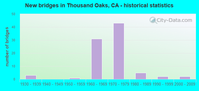
- New bridges - historical statistics
- 31930-1939
- 11950-1959
- 311960-1969
- 431970-1979
- 51980-1989
- 21990-1999
- 22000-2009
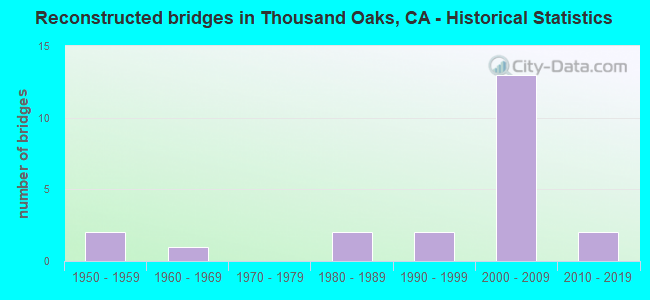
- Reconstructed bridges - Historical Statistics
- 21950-1959
- 11960-1969
- 01970-1979
- 21980-1989
- 21990-1999
- 132000-2009
- 22010-2019
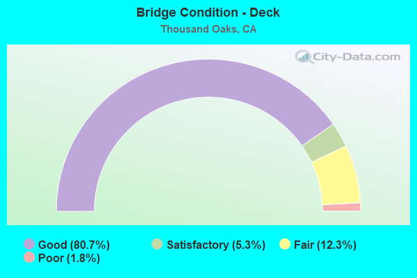
- Bridge Condition - Deck
- 80.7%Good
- 5.3%Satisfactory
- 12.3%Fair
- 1.8%Poor
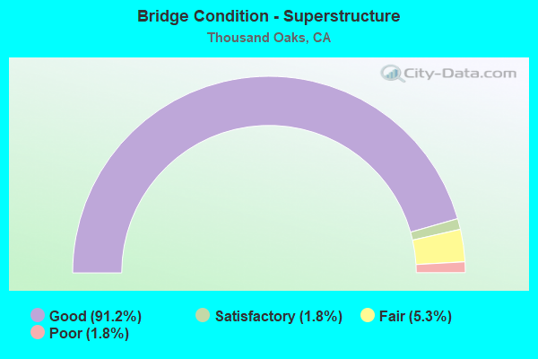
- Bridge Condition - Superstructure
- 91.2%Good
- 1.8%Satisfactory
- 5.3%Fair
- 1.8%Poor
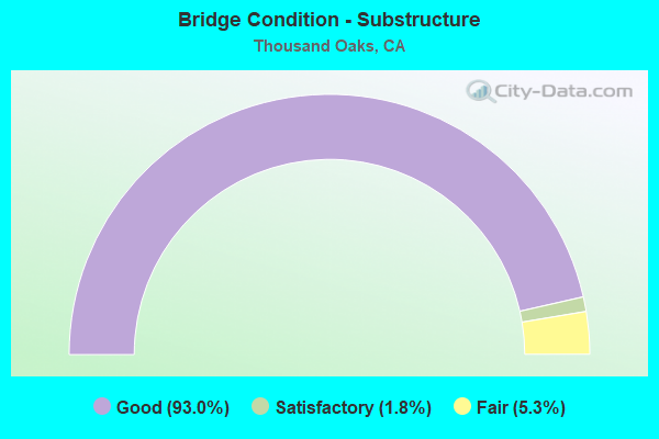
- Bridge Condition - Substructure
- 93.0%Good
- 1.8%Satisfactory
- 5.3%Fair
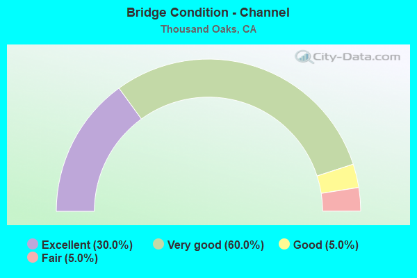
- Bridge Condition - Channel
- 30.0%Excellent
- 60.0%Very good
- 5.0%Good
- 5.0%Fair
Find on map >> Show street view
Structure Number: 52 0014, Location: 07-VEN-101-7.01-THOK (Lat: 34.184550, Lng: -118.925269), Route carried "on" structure: US 101, Year Built: 1954, Year Reconstructed: 2003, Status: Open, Structure Length: 2.19m (7.19ft), Average Daily Traffic: 180,000 (year 2017), Truck Traffic: 8%, Average Future Daily Traffic: 295,200 (year 2037), Design Load: HS 20, Features Intersected: S BRANCH ARROYO CONEJO
Minimum Vertical Clearance: 30+ m (98+ ft), Kilometerpoint: 7.010, Lanes on structure: 9, Base Highway Network: Yes (Inventory Route: 1, Subroute: 1), Owner: State Highway Agency, Approaching Roadway Width: 41.5m (136.2ft), Skew: 34 degrees, Material/Design: Concrete continuous, Design/Construction: Slab, Number Of Spans In Main Unit: 2, Length of Maximum Span: 10.8m (35.4ft), Curb-To-Curb Width: 47.8m (156.8ft), Out-to-Out Width: 49.5m (162.4ft)
Condition: Deck: Good, Superstructure: Good, Substructure: Good, Channel: Very good, Operating Rating: 82.3 metric tons, Method Used To Determine Operating Rating: Load Factor (LF), Inventory Rating: 49.6 metric tons, Method Used To Determine Inventory Rating: Load Factor (LF), Structural Evaluation: Better than present minimum criteria, Deck Geometry: Superior to present desirable criteria, Waterway Adequacy: Equal to present desirable criteria, Approach Roadway Alignment: Equal to present desirable criteria, Designated Inspection Frequency: Every 48 months, Inspection Date: July 2020, Deck Structure Type: Concrete Cast-file-Place, Wearing Surface/Protective System: Wearing Surface: Monolithic Concrete
Find on map >> Show street view
Structure Number: 52 004, Location: 07-VEN-001-21.54 (Lat: 34.292511, Lng: -119.338222), Route carried "on" structure: State highway 1, Year Built: 1934, Year Reconstructed: 1961, Status: Open, Structure Length: 17.37m (56.99ft), Average Daily Traffic: 4,000 (year 2020), Truck Traffic: 2%, Average Future Daily Traffic: 5,238 (year 2042), Design Load: H 15, Features Intersected: UP RR & AMTRAK
Minimum Vertical Clearance: 30+ m (98+ ft), Kilometerpoint: 21.540, Lanes on structure: 2, Owner: State Highway Agency, Approaching Roadway Width: 15.8m (51.8ft), Material/Design: Steel, Design/Construction: Stringer/Multi-beam, Number Of Spans In Main Unit: 1, Number Of Approach Spans: 11, Length of Maximum Span: 29.0m (95.1ft), Curb-To-Curb Width: 13.6m (44.6ft), Out-to-Out Width: 14.6m (47.9ft)
Condition: Deck: Good, Superstructure: Fair, Substructure: Good, Operating Rating: 24.3 metric tons, Method Used To Determine Operating Rating: Load Factor (LF), Inventory Rating: 14.6 metric tons, Method Used To Determine Inventory Rating: Load Factor (LF), Structural Evaluation: Meets minimum limits, Deck Geometry: Superior to present desirable criteria, Underclear: High priority of corrective action, Approach Roadway Alignment: Equal to present desirable criteria, Designated Inspection Frequency: Every 12 months, Inspection Date: January 2022, Deck Structure Type: Concrete Cast-file-Place, Wearing Surface/Protective System: Wearing Surface: Bituminous
Find on map >> Show street view
Structure Number: 52 0046, Location: 07-VEN-023-T1.53-THOK (Lat: 34.143069, Lng: -118.849192), Route carried "on" structure: State highway 23, Year Built: 1968, Status: Open, Structure Length: 1.01m (3.31ft), Average Daily Traffic: 19,000 (year 2015), Truck Traffic: 8%, Average Future Daily Traffic: 25,229 (year 2039), Design Load: HS 20, Features Intersected: LAKE ELEANOR CREEK
Minimum Vertical Clearance: 30+ m (98+ ft), Kilometerpoint: 1.530, Lanes on structure: 2, Base Highway Network: Yes (, Subroute: 1), Owner: State Highway Agency, Approaching Roadway Width: 32.9m (107.9ft), Skew: 4 degrees, Material/Design: Concrete continuous, Design/Construction: Culvert, Number Of Spans In Main Unit: 2, Length of Maximum Span: 4.9m (16.1ft), Curb-To-Curb Width: 32.9m (107.9ft), Out-to-Out Width: 46.6m (152.9ft)
Condition: Channel: Very good, Culverts: Good, Operating Rating: 54.1 metric tons, Method Used To Determine Operating Rating: Field evaluation and documented engineering judgment, Inventory Rating: 32.4 metric tons, Method Used To Determine Inventory Rating: Field evaluation and documented engineering judgment, Structural Evaluation: Better than present minimum criteria, Deck Geometry: Superior to present desirable criteria, Waterway Adequacy: Equal to present desirable criteria, Approach Roadway Alignment: Equal to present desirable criteria, Designated Inspection Frequency: Every 48 months, Inspection Date: June 2021, Deck Structure Type: Concrete Cast-file-Place
Find on map >> Show street view
Structure Number: 52 0230L, Location: 07-VEN-118-0.52 (Lat: 34.289861, Lng: -119.156747), Route carried "on" structure: State highway 118, Year Built: 1994, Status: Open, Structure Length: 7.53m (24.70ft), Average Daily Traffic: 19,500 (year 2019), Truck Traffic: 10%, Average Future Daily Traffic: 25,000 (year 2039), Design Load: HS 20, Features Intersected: STATE ROUTE 126
Minimum Vertical Clearance: 30+ m (98+ ft), Kilometerpoint: 0.520, Lanes on structure: 2, Lanes under structure: 7, Base Highway Network: Yes (Inventory Route: 1, Subroute: 1), Owner: State Highway Agency, Approaching Roadway Width: 11.3m (37.1ft), Material/Design: Prestressed concrete continuous, Design/Construction: Box Beam or Girders - Multiple, Number Of Spans In Main Unit: 4, Length of Maximum Span: 20.4m (66.9ft), Curb-To-Curb Width: 11.3m (37.1ft), Out-to-Out Width: 13.7m (44.9ft)
Condition: Deck: Good, Superstructure: Good, Substructure: Good, Operating Rating: 54.0 metric tons, Method Used To Determine Operating Rating: Field evaluation and documented engineering judgment, Inventory Rating: 32.4 metric tons, Method Used To Determine Inventory Rating: Field evaluation and documented engineering judgment, Structural Evaluation: Better than present minimum criteria, Deck Geometry: Equal to present minimum criteria, Underclear: High priority of corrective action, Approach Roadway Alignment: Equal to present desirable criteria, Designated Inspection Frequency: Every 24 months, Inspection Date: January 2021, Deck Structure Type: Concrete Cast-file-Place
Find on map >> Show street view
Structure Number: 52 0237, Location: 07-VEN-101-4.06-THOK (Lat: 34.177492, Lng: -118.876247), Route carried "on" structure: US 101, Year Built: 1962, Status: Open, Structure Length: 5.24m (17.19ft), Average Daily Traffic: 192,000 (year 2017), Truck Traffic: 9%, Average Future Daily Traffic: 289,920 (year 2038), Design Load: HS 20+Mod, Features Intersected: MOORPARK RD
Minimum Vertical Clearance: 30+ m (98+ ft), Kilometerpoint: 4.060, Lanes on structure: 7, Lanes under structure: 6, Base Highway Network: Yes (Inventory Route: 1, Subroute: 1), Owner: State Highway Agency, Approaching Roadway Width: 37.2m (122.0ft), Skew: 30 degrees, Material/Design: Concrete continuous, Design/Construction: Tee Beam, Number Of Spans In Main Unit: 4, Length of Maximum Span: 15.2m (49.9ft), Curb-To-Curb Width: 37.2m (122.0ft), Out-to-Out Width: 38.7m (127.0ft)
Condition: Deck: Satisfactory, Superstructure: Good, Substructure: Good, Operating Rating: 52.8 metric tons, Method Used To Determine Operating Rating: Load Factor (LF), Inventory Rating: 31.8 metric tons, Method Used To Determine Inventory Rating: Load Factor (LF), Structural Evaluation: Better than present minimum criteria, Deck Geometry: Superior to present desirable criteria, Underclear: Meets minimum limits, Approach Roadway Alignment: Superior to present desirable criteria, Designated Inspection Frequency: Every 24 months, Inspection Date: July 2020, Deck Structure Type: Concrete Cast-file-Place
Find on map >> Show street view
Structure Number: 52 024, Location: 07-VEN-033-0.31-VEN (Lat: 34.283433, Lng: -119.305189), Route carried "on" structure: State highway 33, Year Built: 1963, Status: Open, Structure Length: 5.09m (16.70ft), Average Daily Traffic: 42,000 (year 2010), Truck Traffic: 6%, Average Future Daily Traffic: 52,333 (year 2042), Design Load: HS 20, Features Intersected: S33-MAIN ST OFF-RAMP
Minimum Vertical Clearance: 30+ m (98+ ft), Kilometerpoint: 0.310, Lanes on structure: 4, Lanes under structure: 2, Base Highway Network: Yes (, Subroute: 1), Owner: State Highway Agency, Approaching Roadway Width: 26.2m (86.0ft), Skew: 39 degrees, Material/Design: Concrete continuous, Design/Construction: Box Beam or Girders - Multiple, Number Of Spans In Main Unit: 3, Length of Maximum Span: 25.9m (85.0ft), Curb-To-Curb Width: 26.2m (86.0ft), Out-to-Out Width: 27.0m (88.6ft)
Condition: Deck: Fair, Superstructure: Good, Substructure: Good, Operating Rating: 37.9 metric tons, Method Used To Determine Operating Rating: Load and Resistance Factor Rating (LRFR) rating reported by rating factor(RF) method using HL-93 loadings, Inventory Rating: 29.2 metric tons, Method Used To Determine Inventory Rating: Load and Resistance Factor Rating (LRFR) rating reported by rating factor(RF) method using HL-93 loadings, Structural Evaluation: Better than present minimum criteria, Deck Geometry: Superior to present desirable criteria, Underclear: High priority of corrective action, Approach Roadway Alignment: Equal to present desirable criteria, Designated Inspection Frequency: Every 24 months, Inspection Date: Febuary 2022, Deck Structure Type: Concrete Cast-file-Place
Find on map >> Show street view
Structure Number: 52 0247, Location: 07-VEN-101-7.02-THOK (Lat: 34.184019, Lng: -118.925639), Route carried "on" structure: City street , Year Built: 1962, Year Reconstructed: 1992, Status: Open, Structure Length: 8.47m (27.79ft), Average Daily Traffic: 13,463 (year 2019), Truck Traffic: 1%, Average Future Daily Traffic: 20,060 (year 2039), Design Load: HS 20, Features Intersected: ROUTE 101, Facility Carried by Structure: BORCHARD RD
Minimum Vertical Clearance: 30+ m (98+ ft), Kilometerpoint: 0.000, Lanes on structure: 7, Lanes under structure: 8, Owner: State Highway Agency, Approaching Roadway Width: 27.4m (89.9ft), Material/Design: Steel, Design/Construction: Stringer/Multi-beam, Number Of Spans In Main Unit: 3, Length of Maximum Span: 43.9m (144.0ft), Curb or Sidewalk Widths: Left: 0.0m, Right: 1.5m (4.9ft), Curb-To-Curb Width: 27.4m (89.9ft), Out-to-Out Width: 31.4m (103.0ft)
Condition: Deck: Good, Superstructure: Good, Substructure: Good, Operating Rating: 58.4 metric tons, Method Used To Determine Operating Rating: Load Factor (LF), Inventory Rating: 35.4 metric tons, Method Used To Determine Inventory Rating: Load Factor (LF), Structural Evaluation: Better than present minimum criteria, Deck Geometry: Somewhat better than minimum adequacy, Underclear: High priority of corrective action, Approach Roadway Alignment: Equal to present desirable criteria, Designated Inspection Frequency: Every 24 months, Other Special Inspection Frequency: Every 48 months, Inspection Date: July 2020, Other Special Inspection Date: December 2019, Deck Structure Type: Concrete Cast-file-Place
Find on map >> Show street view
Structure Number: 52 0260L, Location: 07-VEN-126-R12.04-SPA (Lat: 34.350058, Lng: -119.058422), Route carried "on" structure: State highway 126, Year Built: 1965, Status: Open, Structure Length: 3.66m (12.01ft), Average Daily Traffic: 18,750 (year 2018), Truck Traffic: 10%, Average Future Daily Traffic: 25,893 (year 2039), Design Load: HS 20, Features Intersected: ROUTE 150 (10TH ST)
Minimum Vertical Clearance: 30+ m (98+ ft), Kilometerpoint: 12.040, Lanes on structure: 2, Lanes under structure: 2, Base Highway Network: Yes (Inventory Route: 1, Subroute: 1), Owner: State Highway Agency, Approaching Roadway Width: 11.3m (37.1ft), Material/Design: Concrete continuous, Design/Construction: Tee Beam, Number Of Spans In Main Unit: 3, Length of Maximum Span: 18.3m (60.0ft), Curb-To-Curb Width: 11.3m (37.1ft), Out-to-Out Width: 12.1m (39.7ft)
Condition: Deck: Fair, Superstructure: Good, Substructure: Good, Operating Rating: 32.4 metric tons, Method Used To Determine Operating Rating: Load and Resistance Factor Rating (LRFR) rating reported by rating factor(RF) method using HL-93 loadings, Inventory Rating: 24.9 metric tons, Method Used To Determine Inventory Rating: Load and Resistance Factor Rating (LRFR) rating reported by rating factor(RF) method using HL-93 loadings, Structural Evaluation: Equal to present minimum criteria, Deck Geometry: Somewhat better than minimum adequacy, Underclear: Meets minimum limits, Approach Roadway Alignment: Equal to present desirable criteria, Designated Inspection Frequency: Every 24 months, Inspection Date: August 2021, Deck Structure Type: Concrete Cast-file-Place
Find on map >> Show street view
Structure Number: 52 0266, Location: 07-VEN-101-7.89-THOK (Lat: 34.189375, Lng: -118.939467), Route carried "on" structure: City street , Year Built: 1967, Year Reconstructed: 2014, Status: Open, Structure Length: 8.68m (28.48ft), Average Daily Traffic: 18,733 (year 2019), Truck Traffic: 2%, Average Future Daily Traffic: 27,912 (year 2039), Design Load: HS 20, Features Intersected: ROUTE 101, Facility Carried by Structure: WENDY DRIVE
Minimum Vertical Clearance: 30+ m (98+ ft), Kilometerpoint: 0.000, Lanes on structure: 8, Lanes under structure: 8, Owner: State Highway Agency, Approaching Roadway Width: 34.7m (113.8ft), Skew: 1 degrees, Material/Design: Steel, Design/Construction: Stringer/Multi-beam, Number Of Spans In Main Unit: 2, Length of Maximum Span: 47.2m (154.9ft), Curb or Sidewalk Widths: Left: 1.8m (5.9ft), Right: 0.0m, Curb-To-Curb Width: 34.7m (113.8ft), Out-to-Out Width: 37.2m (122.0ft)
Condition: Deck: Good, Superstructure: Good, Substructure: Good, Operating Rating: 39.5 metric tons, Method Used To Determine Operating Rating: Load and Resistance Factor Rating (LRFR) rating reported by rating factor(RF) method using HL-93 loadings, Inventory Rating: 30.5 metric tons, Method Used To Determine Inventory Rating: Load and Resistance Factor Rating (LRFR) rating reported by rating factor(RF) method using HL-93 loadings, Structural Evaluation: Better than present minimum criteria, Deck Geometry: Better than present minimum criteria, Underclear: Meets minimum limits, Approach Roadway Alignment: Equal to present desirable criteria, Designated Inspection Frequency: Every 24 months, Other Special Inspection Frequency: Every 48 months, Inspection Date: July 2020, Other Special Inspection Date: October 2018, Deck Structure Type: Concrete Cast-file-Place
Find on map >> Show street view
Structure Number: 52 0268E, Location: 07-VEN-023-R3.29-THOK (Lat: 34.157158, Lng: -118.825219), Route carried "on" structure: State highway 23, Year Built: 1964, Year Reconstructed: 1973, Status: Open, Structure Length: 9.53m (31.27ft), Average Daily Traffic: 37,500 (year 2019), Truck Traffic: 3%, Average Future Daily Traffic: 63,071 (year 2039), Design Load: HS 20, Features Intersected: U.S. HIGHWAY 101
Minimum Vertical Clearance: 30+ m (98+ ft), Kilometerpoint: 3.290, Lanes on structure: 6, Lanes under structure: 12, Base Highway Network: Yes (, Subroute: 1), Owner: State Highway Agency, Approaching Roadway Width: 28.7m (94.2ft), Skew: 20 degrees, Material/Design: Prestressed concrete, Design/Construction: Stringer/Multi-beam, Number Of Spans In Main Unit: 4, Length of Maximum Span: 23.8m (78.1ft), Curb or Sidewalk Widths: Left: 1.5m (4.9ft), Right: 1.5m (4.9ft), Curb-To-Curb Width: 28.7m (94.2ft), Out-to-Out Width: 35.4m (116.1ft)
Condition: Deck: Good, Superstructure: Good, Substructure: Good, Operating Rating: 47.3 metric tons, Method Used To Determine Operating Rating: Load and Resistance Factor Rating (LRFR) rating reported by rating factor(RF) method using HL-93 loadings, Inventory Rating: 25.9 metric tons, Method Used To Determine Inventory Rating: Load and Resistance Factor Rating (LRFR) rating reported by rating factor(RF) method using HL-93 loadings, Structural Evaluation: Equal to present minimum criteria, Deck Geometry: Superior to present desirable criteria, Underclear: Meets minimum limits, Approach Roadway Alignment: Equal to present desirable criteria, Designated Inspection Frequency: Every 24 months, Inspection Date: June 2021, Deck Structure Type: Concrete Cast-file-Place
Find on map >> Show street view
Structure Number: 52 027, Location: 07-VEN-101-17.75-CMRL (Lat: 34.221550, Lng: -119.101864), Route carried "on" structure: City street N036, Year Built: 1964, Status: Open, Structure Length: 6.24m (20.47ft), Average Daily Traffic: 8,508 (year 2019), Truck Traffic: 2%, Average Future Daily Traffic: 12,677 (year 2039), Design Load: HS 20, Features Intersected: ROUTE 101, Facility Carried by Structure: CENTRAL AVE
Minimum Vertical Clearance: 30+ m (98+ ft), Kilometerpoint: 0.000, Lanes on structure: 2, Lanes under structure: 6, Owner: State Highway Agency, Approaching Roadway Width: 12.4m (40.7ft), Skew: 1 degrees, Material/Design: Prestressed concrete, Design/Construction: Stringer/Multi-beam, Number Of Spans In Main Unit: 4, Length of Maximum Span: 22.1m (72.5ft), Curb or Sidewalk Widths: Left: 1.5m (4.9ft), Right: 0.0m, Curb-To-Curb Width: 12.4m (40.7ft), Out-to-Out Width: 14.6m (47.9ft)
Condition: Deck: Good, Superstructure: Poor, Substructure: Good, Operating Rating: 34.0 metric tons, Method Used To Determine Operating Rating: Load and Resistance Factor Rating (LRFR) rating reported by rating factor(RF) method using HL-93 loadings, Inventory Rating: 26.2 metric tons, Method Used To Determine Inventory Rating: Load and Resistance Factor Rating (LRFR) rating reported by rating factor(RF) method using HL-93 loadings, Structural Evaluation: Meets minimum limits, Deck Geometry: Somewhat better than minimum adequacy, Underclear: Meets minimum limits, Approach Roadway Alignment: Equal to present desirable criteria, Length Of Structure Improvement: 6.24m (20.47ft), Designated Inspection Frequency: Every 24 months, Inspection Date: August 2020, Bridge Improvement Cost: $910,000, Roadway Improvement Cost: $182,000, Total Project Cost: $1,528,000 ( Estimate for 2019), Deck Structure Type: Concrete Cast-file-Place
Find on map >> Show street view
Structure Number: 52 0273, Location: 07-VEN-101-1.62-THOK (Lat: 34.166164, Lng: -118.837600), Route carried "on" structure: US 101, Year Built: 1966, Year Reconstructed: 2016, Status: Open, Structure Length: 4.50m (14.76ft), Average Daily Traffic: 193,000 (year 2017), Truck Traffic: 9%, Average Future Daily Traffic: 263,495 (year 2037), Design Load: HS 20, Features Intersected: HAMPSHIRE RD
Minimum Vertical Clearance: 30+ m (98+ ft), Kilometerpoint: 1.620, Lanes on structure: 10, Lanes under structure: 6, Base Highway Network: Yes (Inventory Route: 1, Subroute: 1), Owner: State Highway Agency, Approaching Roadway Width: 49.4m (162.1ft), Skew: 31 degrees, Material/Design: Concrete continuous, Design/Construction: Tee Beam, Number Of Spans In Main Unit: 3, Length of Maximum Span: 23.0m (75.5ft), Curb-To-Curb Width: 49.4m (162.1ft), Out-to-Out Width: 50.8m (166.7ft)
Condition: Deck: Satisfactory, Superstructure: Good, Substructure: Good, Operating Rating: 42.8 metric tons, Method Used To Determine Operating Rating: Load and Resistance Factor Rating (LRFR) rating reported by rating factor(RF) method using HL-93 loadings, Inventory Rating: 33.0 metric tons, Method Used To Determine Inventory Rating: Load and Resistance Factor Rating (LRFR) rating reported by rating factor(RF) method using HL-93 loadings, Structural Evaluation: Better than present minimum criteria, Deck Geometry: Superior to present desirable criteria, Underclear: Somewhat better than minimum adequacy, Approach Roadway Alignment: Superior to present desirable criteria, Designated Inspection Frequency: Every 24 months, Inspection Date: July 2020, Deck Structure Type: Concrete Cast-file-Place
Find on map >> Show street view
Structure Number: 52 0274, Location: 07-VEN-101-2.25-THOK (Lat: 34.171808, Lng: -118.846039), Route carried "on" structure: US 101, Year Built: 1966, Year Reconstructed: 2016, Status: Open, Structure Length: 3.75m (12.30ft), Average Daily Traffic: 193,000 (year 2017), Truck Traffic: 9%, Average Future Daily Traffic: 263,495 (year 2037), Design Load: HS 20+Mod, Features Intersected: CONEJO SCHOOL RD
Minimum Vertical Clearance: 30+ m (98+ ft), Kilometerpoint: 2.250, Lanes on structure: 12, Lanes under structure: 2, Base Highway Network: Yes (Inventory Route: 1, Subroute: 1), Owner: State Highway Agency, Approaching Roadway Width: 56.7m (186.0ft), Skew: 20 degrees, Material/Design: Concrete continuous, Design/Construction: Tee Beam, Number Of Spans In Main Unit: 3, Length of Maximum Span: 16.8m (55.1ft), Curb-To-Curb Width: 56.7m (186.0ft), Out-to-Out Width: 58.1m (190.6ft)
Condition: Deck: Satisfactory, Superstructure: Good, Substructure: Good, Operating Rating: 39.2 metric tons, Method Used To Determine Operating Rating: Load and Resistance Factor Rating (LRFR) rating reported by rating factor(RF) method using HL-93 loadings, Inventory Rating: 30.5 metric tons, Method Used To Determine Inventory Rating: Load and Resistance Factor Rating (LRFR) rating reported by rating factor(RF) method using HL-93 loadings, Structural Evaluation: Better than present minimum criteria, Deck Geometry: Superior to present desirable criteria, Underclear: Equal to present minimum criteria, Approach Roadway Alignment: Superior to present desirable criteria, Designated Inspection Frequency: Every 24 months, Inspection Date: July 2020, Deck Structure Type: Concrete Cast-file-Place
Find on map >> Show street view
Structure Number: 52 0280R, Location: 07-VEN-101-6.19-THOK (Lat: 34.184042, Lng: -118.911003), Route carried "on" structure: City street , Year Built: 1966, Status: Open, Structure Length: 6.89m (22.60ft), Average Daily Traffic: 4,636 (year 2019), Truck Traffic: 1%, Average Future Daily Traffic: 6,908 (year 2039), Design Load: HS 20, Features Intersected: US 101, Facility Carried by Structure: VENTU PARK ROAD
Minimum Vertical Clearance: 30+ m (98+ ft), Kilometerpoint: 0.000, Lanes on structure: 2, Lanes under structure: 8, Owner: State Highway Agency, Approaching Roadway Width: 10.4m (34.1ft), Material/Design: Prestressed concrete continuous, Design/Construction: Stringer/Multi-beam, Number Of Spans In Main Unit: 2, Length of Maximum Span: 34.1m (111.9ft), Curb-To-Curb Width: 11.0m (36.1ft), Out-to-Out Width: 11.6m (38.1ft)
Condition: Deck: Good, Superstructure: Good, Substructure: Good, Operating Rating: 51.2 metric tons, Method Used To Determine Operating Rating: Load and Resistance Factor Rating (LRFR) rating reported by rating factor(RF) method using HL-93 loadings, Inventory Rating: 24.3 metric tons, Method Used To Determine Inventory Rating: Load and Resistance Factor Rating (LRFR) rating reported by rating factor(RF) method using HL-93 loadings, Structural Evaluation: Equal to present minimum criteria, Deck Geometry: Equal to present minimum criteria, Underclear: Equal to present minimum criteria, Approach Roadway Alignment: Equal to present desirable criteria, Designated Inspection Frequency: Every 24 months, Inspection Date: July 2020, Deck Structure Type: Concrete Cast-file-Place
Find on map >> Show street view
Structure Number: 52 0286S, Location: 07-VEN-101-6.92-THOK (Lat: 34.184878, Lng: -118.923922), Route carried "on" structure: Bypass US 101, Year Built: 1967, Status: Open, Structure Length: 2.74m (8.99ft), Average Daily Traffic: 4,951 (year 2013), Truck Traffic: 2%, Average Future Daily Traffic: 13,170 (year 2038), Design Load: HS 20, Features Intersected: S BR ARROYO CONEJO(OFF)
Minimum Vertical Clearance: 30+ m (98+ ft), Kilometerpoint: 6.920, Lanes on structure: 2, Base Highway Network: Yes (Inventory Route: 1, Subroute: 1), Owner: State Highway Agency, Approaching Roadway Width: 10.4m (34.1ft), Skew: 4 degrees, Material/Design: Concrete, Design/Construction: Box Beam or Girders - Multiple, Number Of Spans In Main Unit: 1, Length of Maximum Span: 26.7m (87.6ft), Curb-To-Curb Width: 10.4m (34.1ft), Out-to-Out Width: 11.6m (38.1ft)
Condition: Deck: Poor, Superstructure: Good, Substructure: Good, Channel: Very good, Operating Rating: 68.0 metric tons, Method Used To Determine Operating Rating: Load and Resistance Factor Rating (LRFR) rating reported by rating factor(RF) method using HL-93 loadings, Inventory Rating: 48.9 metric tons, Method Used To Determine Inventory Rating: Load and Resistance Factor Rating (LRFR) rating reported by rating factor(RF) method using HL-93 loadings, Structural Evaluation: Better than present minimum criteria, Deck Geometry: Meets minimum limits, Waterway Adequacy: Equal to present desirable criteria, Approach Roadway Alignment: Equal to present minimum criteria, Designated Inspection Frequency: Every 24 months, Inspection Date: July 2020, Deck Structure Type: Concrete Cast-file-Place
Find on map >> Show street view
Structure Number: 52 0301, Location: 07-VEN-118-R29.32-SIMV (Lat: 34.281992, Lng: -118.682833), Route carried "on" structure: City street , Year Built: 1968, Status: Open, Structure Length: 8.04m (26.38ft), Average Daily Traffic: 720 (year 2019), Truck Traffic: 1%, Average Future Daily Traffic: 1,158 (year 2041), Design Load: HS 20, Features Intersected: ROUTE 118, Facility Carried by Structure: STOW STREET
Minimum Vertical Clearance: 30+ m (98+ ft), Kilometerpoint: 0.000, Lanes on structure: 2, Lanes under structure: 8, Owner: State Highway Agency, Approaching Roadway Width: 9.8m (32.2ft), Material/Design: Prestressed concrete continuous, Design/Construction: Box Beam or Girders - Multiple, Number Of Spans In Main Unit: 2, Length of Maximum Span: 44.8m (147.0ft), Curb or Sidewalk Widths: Left: 1.5m (4.9ft), Right: 1.5m (4.9ft), Curb-To-Curb Width: 9.8m (32.2ft), Out-to-Out Width: 13.9m (45.6ft)
Condition: Deck: Good, Superstructure: Good, Substructure: Good, Operating Rating: 51.8 metric tons, Method Used To Determine Operating Rating: Load and Resistance Factor Rating (LRFR) rating reported by rating factor(RF) method using HL-93 loadings, Inventory Rating: 28.8 metric tons, Method Used To Determine Inventory Rating: Load and Resistance Factor Rating (LRFR) rating reported by rating factor(RF) method using HL-93 loadings, Structural Evaluation: Better than present minimum criteria, Deck Geometry: Equal to present minimum criteria, Underclear: Meets minimum limits, Approach Roadway Alignment: Equal to present desirable criteria, Designated Inspection Frequency: Every 24 months, Inspection Date: Febuary 2021, Deck Structure Type: Concrete Cast-file-Place
Find on map >> Show street view
Structure Number: 52 0304L, Location: 07-VEN-023-R7.75-THOK (Lat: 34.235050, Lng: -118.842617), Route carried "on" structure: State highway 23, Year Built: 1970, Year Reconstructed: 2008, Status: Open, Structure Length: 4.33m (14.21ft), Average Daily Traffic: 89,000 (year 2015), Truck Traffic: 10%, Average Future Daily Traffic: 147,786 (year 2041), Design Load: HS 20, Features Intersected: ERBES ROAD
Minimum Vertical Clearance: 30+ m (98+ ft), Kilometerpoint: 7.750, Lanes on structure: 3, Lanes under structure: 2, Base Highway Network: Yes (, Subroute: 1), Owner: State Highway Agency, Approaching Roadway Width: 19.5m (64.0ft), Skew: 2 degrees, Material/Design: Prestressed concrete, Design/Construction: Box Beam or Girders - Multiple, Number Of Spans In Main Unit: 1, Length of Maximum Span: 43.1m (141.4ft), Curb-To-Curb Width: 19.5m (64.0ft), Out-to-Out Width: 20.3m (66.6ft)
Condition: Deck: Good, Superstructure: Good, Substructure: Good, Operating Rating: 97.8 metric tons, Method Used To Determine Operating Rating: Load Factor (LF), Inventory Rating: 32.4 metric tons, Method Used To Determine Inventory Rating: Load Factor (LF), Structural Evaluation: Better than present minimum criteria, Deck Geometry: Superior to present desirable criteria, Underclear: Superior to present desirable criteria, Approach Roadway Alignment: Equal to present desirable criteria, Designated Inspection Frequency: Every 24 months, Inspection Date: June 2021, Deck Structure Type: Concrete Cast-file-Place
Find on map >> Show street view
Structure Number: 52 0304R, Location: 07-VEN-023-R7.74-THOK (Lat: 34.234828, Lng: -118.842394), Route carried "on" structure: State highway 23, Year Built: 1970, Year Reconstructed: 2008, Status: Open, Structure Length: 4.30m (14.11ft), Average Daily Traffic: 89,000 (year 2015), Truck Traffic: 10%, Average Future Daily Traffic: 147,786 (year 2041), Design Load: HS 20, Features Intersected: ERBES ROAD
Minimum Vertical Clearance: 30+ m (98+ ft), Kilometerpoint: 7.740, Lanes on structure: 3, Lanes under structure: 2, Base Highway Network: Yes (, Subroute: 1), Owner: State Highway Agency, Approaching Roadway Width: 18.5m (60.7ft), Skew: 2 degrees, Material/Design: Prestressed concrete, Design/Construction: Box Beam or Girders - Multiple, Number Of Spans In Main Unit: 1, Length of Maximum Span: 42.8m (140.4ft), Curb-To-Curb Width: 18.5m (60.7ft), Out-to-Out Width: 19.4m (63.6ft)
Condition: Deck: Good, Superstructure: Good, Substructure: Good, Operating Rating: 53.1 metric tons, Method Used To Determine Operating Rating: Load and Resistance Factor Rating (LRFR) rating reported by rating factor(RF) method using HL-93 loadings, Inventory Rating: 36.0 metric tons, Method Used To Determine Inventory Rating: Load and Resistance Factor Rating (LRFR) rating reported by rating factor(RF) method using HL-93 loadings, Structural Evaluation: Better than present minimum criteria, Deck Geometry: Superior to present desirable criteria, Underclear: Superior to present desirable criteria, Approach Roadway Alignment: Equal to present desirable criteria, Designated Inspection Frequency: Every 24 months, Inspection Date: June 2021, Deck Structure Type: Concrete Cast-file-Place
Find on map >> Show street view
Structure Number: 52 0305L, Location: 07-VEN-023-R5.06-THOK (Lat: 34.199797, Lng: -118.857275), Route carried "on" structure: State highway 23, Year Built: 1970, Year Reconstructed: 2008, Status: Open, Structure Length: 4.24m (13.91ft), Average Daily Traffic: 94,000 (year 2015), Truck Traffic: 10%, Average Future Daily Traffic: 156,111 (year 2041), Design Load: HS 20, Features Intersected: JANSS ROAD
Minimum Vertical Clearance: 30+ m (98+ ft), Kilometerpoint: 5.060, Lanes on structure: 4, Lanes under structure: 4, Base Highway Network: Yes (, Subroute: 1), Owner: State Highway Agency, Approaching Roadway Width: 24.2m (79.4ft), Skew: 2 degrees, Material/Design: Prestressed concrete, Design/Construction: Box Beam or Girders - Multiple, Number Of Spans In Main Unit: 1, Length of Maximum Span: 41.3m (135.5ft), Curb-To-Curb Width: 24.2m (79.4ft), Out-to-Out Width: 25.0m (82.0ft)
Condition: Deck: Good, Superstructure: Good, Substructure: Good, Operating Rating: 90.7 metric tons, Method Used To Determine Operating Rating: Load Factor (LF), Inventory Rating: 32.4 metric tons, Method Used To Determine Inventory Rating: Load Factor (LF), Structural Evaluation: Better than present minimum criteria, Deck Geometry: Superior to present desirable criteria, Underclear: Better than present minimum criteria, Approach Roadway Alignment: Equal to present desirable criteria, Designated Inspection Frequency: Every 24 months, Inspection Date: June 2021, Deck Structure Type: Concrete Cast-file-Place
Find on map >> Show street view
Structure Number: 52 0305R, Location: 07-VEN-023-R5.06-THOK (Lat: 34.199761, Lng: -118.856864), Route carried "on" structure: State highway 23, Year Built: 1970, Year Reconstructed: 2008, Status: Open, Structure Length: 4.24m (13.91ft), Average Daily Traffic: 94,000 (year 2015), Truck Traffic: 10%, Average Future Daily Traffic: 156,111 (year 2041), Design Load: HS 20, Features Intersected: JANSS ROAD
Minimum Vertical Clearance: 30+ m (98+ ft), Kilometerpoint: 5.060, Lanes on structure: 4, Lanes under structure: 4, Base Highway Network: Yes (, Subroute: 1), Owner: State Highway Agency, Approaching Roadway Width: 22.9m (75.1ft), Skew: 2 degrees, Material/Design: Prestressed concrete, Design/Construction: Box Beam or Girders - Multiple, Number Of Spans In Main Unit: 1, Length of Maximum Span: 41.3m (135.5ft), Curb-To-Curb Width: 22.9m (75.1ft), Out-to-Out Width: 23.6m (77.4ft)
Condition: Deck: Good, Superstructure: Good, Substructure: Good, Operating Rating: 46.0 metric tons, Method Used To Determine Operating Rating: Load and Resistance Factor Rating (LRFR) rating reported by rating factor(RF) method using HL-93 loadings, Inventory Rating: 25.3 metric tons, Method Used To Determine Inventory Rating: Load and Resistance Factor Rating (LRFR) rating reported by rating factor(RF) method using HL-93 loadings, Structural Evaluation: Equal to present minimum criteria, Deck Geometry: Superior to present desirable criteria, Underclear: Equal to present minimum criteria, Approach Roadway Alignment: Equal to present desirable criteria, Designated Inspection Frequency: Every 24 months, Inspection Date: June 2021, Deck Structure Type: Concrete Cast-file-Place
Find on map >> Show street view
Structure Number: 52 0306L, Location: 07-VEN-023-R3.71-THOK (Lat: 34.181311, Lng: -118.860581), Route carried "on" structure: State highway 23, Year Built: 1970, Status: Open, Structure Length: 4.15m (13.62ft), Average Daily Traffic: 94,000 (year 2015), Truck Traffic: 10%, Average Future Daily Traffic: 156,111 (year 2041), Design Load: HS 20, Features Intersected: HILLCREST DRIVE
Minimum Vertical Clearance: 30+ m (98+ ft), Kilometerpoint: 3.710, Lanes on structure: 4, Lanes under structure: 5, Base Highway Network: Yes (, Subroute: 1), Owner: State Highway Agency, Approaching Roadway Width: 19.0m (62.3ft), Skew: 2 degrees, Material/Design: Prestressed concrete, Design/Construction: Box Beam or Girders - Multiple, Number Of Spans In Main Unit: 1, Length of Maximum Span: 41.5m (136.2ft), Curb-To-Curb Width: 19.0m (62.3ft), Out-to-Out Width: 19.8m (65.0ft)
Condition: Deck: Good, Superstructure: Good, Substructure: Good, Operating Rating: 82.0 metric tons, Method Used To Determine Operating Rating: Load Factor (LF), Inventory Rating: 32.4 metric tons, Method Used To Determine Inventory Rating: Load Factor (LF), Structural Evaluation: Better than present minimum criteria, Deck Geometry: Meets minimum limits, Underclear: Meets minimum limits, Approach Roadway Alignment: Better than present minimum criteria, Designated Inspection Frequency: Every 24 months, Inspection Date: June 2021, Deck Structure Type: Concrete Cast-file-Place
Find on map >> Show street view
Structure Number: 52 0306R, Location: 07-VEN-023-R3.70-THOK (Lat: 34.181147, Lng: -118.860175), Route carried "on" structure: State highway 23, Year Built: 1970, Status: Open, Structure Length: 4.34m (14.24ft), Average Daily Traffic: 94,000 (year 2015), Truck Traffic: 10%, Average Future Daily Traffic: 156,111 (year 2041), Design Load: HS 20, Features Intersected: HILLCREST DRIVE
Minimum Vertical Clearance: 30+ m (98+ ft), Kilometerpoint: 3.700, Lanes on structure: 3, Lanes under structure: 5, Base Highway Network: Yes (, Subroute: 1), Owner: State Highway Agency, Approaching Roadway Width: 22.2m (72.8ft), Skew: 2 degrees, Material/Design: Prestressed concrete, Design/Construction: Box Beam or Girders - Multiple, Number Of Spans In Main Unit: 1, Length of Maximum Span: 43.4m (142.4ft), Curb-To-Curb Width: 21.2m (69.6ft), Out-to-Out Width: 21.2m (69.6ft)
Condition: Deck: Good, Superstructure: Good, Substructure: Good, Operating Rating: 50.9 metric tons, Method Used To Determine Operating Rating: Load and Resistance Factor Rating (LRFR) rating reported by rating factor(RF) method using HL-93 loadings, Inventory Rating: 39.2 metric tons, Method Used To Determine Inventory Rating: Load and Resistance Factor Rating (LRFR) rating reported by rating factor(RF) method using HL-93 loadings, Structural Evaluation: Better than present minimum criteria, Deck Geometry: Superior to present desirable criteria, Underclear: Meets minimum limits, Approach Roadway Alignment: Equal to present desirable criteria, Designated Inspection Frequency: Every 24 months, Inspection Date: June 2021, Deck Structure Type: Concrete Cast-file-Place
Find on map >> Show street view
Structure Number: 52 0307F, Location: 07-VEN-023-R3.56-THOK (Lat: 34.179131, Lng: -118.861069), Route carried "on" structure: Ramp State highway 23, Year Built: 1970, Status: Open, Structure Length: 5.90m (19.36ft), Average Daily Traffic: 14,600 (year 2015), Truck Traffic: 2%, Average Future Daily Traffic: 21,024 (year 2039), Design Load: HS 20, Features Intersected: THOUSAND OAKS BLVD
Minimum Vertical Clearance: 30+ m (98+ ft), Kilometerpoint: 3.560, Lanes on structure: 2, Lanes under structure: 4, Base Highway Network: Yes (, Subroute: 1), Owner: State Highway Agency, Approaching Roadway Width: 11.9m (39.0ft), Material/Design: Concrete continuous, Design/Construction: Box Beam or Girders - Multiple, Number Of Spans In Main Unit: 3, Length of Maximum Span: 32.2m (105.6ft), Curb-To-Curb Width: 11.9m (39.0ft), Out-to-Out Width: 12.5m (41.0ft)
Condition: Deck: Fair, Superstructure: Good, Substructure: Good, Operating Rating: 52.5 metric tons, Method Used To Determine Operating Rating: Load and Resistance Factor Rating (LRFR) rating reported by rating factor(RF) method using HL-93 loadings, Inventory Rating: 40.5 metric tons, Method Used To Determine Inventory Rating: Load and Resistance Factor Rating (LRFR) rating reported by rating factor(RF) method using HL-93 loadings, Structural Evaluation: Better than present minimum criteria, Deck Geometry: Superior to present desirable criteria, Underclear: Equal to present minimum criteria, Approach Roadway Alignment: Equal to present desirable criteria, Designated Inspection Frequency: Every 24 months, Inspection Date: June 2021, Deck Structure Type: Concrete Cast-file-Place
Find on map >> Show street view
Structure Number: 52 0307G, Location: 07-VEN-101-3.14-THOK (Lat: 34.178789, Lng: -118.859875), Route carried "on" structure: Ramp US 101, Year Built: 1970, Status: Open, Structure Length: 6.74m (22.11ft), Average Daily Traffic: 23,801 (year 2013), Truck Traffic: 2%, Average Future Daily Traffic: 34,650 (year 2038), Design Load: HS 20+Mod, Features Intersected: THOUSAND OAKS BLVD
Minimum Vertical Clearance: 30+ m (98+ ft), Kilometerpoint: 3.140, Lanes on structure: 2, Lanes under structure: 5, Base Highway Network: Yes (Inventory Route: 1, Subroute: 1), Owner: State Highway Agency, Approaching Roadway Width: 11.9m (39.0ft), Skew: 3 degrees, Material/Design: Concrete continuous, Design/Construction: Box Beam or Girders - Multiple, Number Of Spans In Main Unit: 3, Length of Maximum Span: 36.9m (121.1ft), Curb-To-Curb Width: 11.9m (39.0ft), Out-to-Out Width: 12.5m (41.0ft)
Condition: Deck: Good, Superstructure: Good, Substructure: Good, Operating Rating: 59.0 metric tons, Method Used To Determine Operating Rating: Load and Resistance Factor Rating (LRFR) rating reported by rating factor(RF) method using HL-93 loadings, Inventory Rating: 42.4 metric tons, Method Used To Determine Inventory Rating: Load and Resistance Factor Rating (LRFR) rating reported by rating factor(RF) method using HL-93 loadings, Structural Evaluation: Better than present minimum criteria, Deck Geometry: Superior to present desirable criteria, Underclear: Equal to present minimum criteria, Approach Roadway Alignment: Somewhat better than minimum adequacy, Designated Inspection Frequency: Every 24 months, Inspection Date: July 2020, Deck Structure Type: Concrete Cast-file-Place
Find on map >> Show street view
Structure Number: 52 0308L, Location: 07-VEN-023-R6.03-THOK (Lat: 34.211436, Lng: -118.849194), Route carried "on" structure: State highway 23, Year Built: 1970, Year Reconstructed: 2008, Status: Open, Structure Length: 3.90m (12.80ft), Average Daily Traffic: 94,000 (year 2015), Truck Traffic: 10%, Average Future Daily Traffic: 156,111 (year 2041), Design Load: HS 20, Features Intersected: AVENIDA DE LOS ARBOLES
Minimum Vertical Clearance: 30+ m (98+ ft), Kilometerpoint: 6.030, Lanes on structure: 4, Lanes under structure: 4, Base Highway Network: Yes (, Subroute: 1), Owner: State Highway Agency, Approaching Roadway Width: 23.8m (78.1ft), Material/Design: Prestressed concrete, Design/Construction: Box Beam or Girders - Multiple, Number Of Spans In Main Unit: 1, Length of Maximum Span: 38.4m (126.0ft), Curb-To-Curb Width: 23.8m (78.1ft), Out-to-Out Width: 24.5m (80.4ft)
Condition: Deck: Good, Superstructure: Good, Substructure: Good, Operating Rating: 55.7 metric tons, Method Used To Determine Operating Rating: Load and Resistance Factor Rating (LRFR) rating reported by rating factor(RF) method using HL-93 loadings, Inventory Rating: 42.8 metric tons, Method Used To Determine Inventory Rating: Load and Resistance Factor Rating (LRFR) rating reported by rating factor(RF) method using HL-93 loadings, Structural Evaluation: Better than present minimum criteria, Deck Geometry: Superior to present desirable criteria, Underclear: Equal to present minimum criteria, Approach Roadway Alignment: Equal to present desirable criteria, Designated Inspection Frequency: Every 24 months, Inspection Date: June 2021, Deck Structure Type: Concrete Cast-file-Place
Find on map >> Show street view
Structure Number: 52 0308R, Location: 07-VEN-023-R6.03-THOK (Lat: 34.211403, Lng: -118.848794), Route carried "on" structure: State highway 23, Year Built: 1970, Year Reconstructed: 2008, Status: Open, Structure Length: 3.90m (12.80ft), Average Daily Traffic: 94,000 (year 2015), Truck Traffic: 10%, Average Future Daily Traffic: 156,111 (year 2041), Design Load: HS 20, Features Intersected: AVENIDA DE LOS ARBOLES
Minimum Vertical Clearance: 30+ m (98+ ft), Kilometerpoint: 6.030, Lanes on structure: 4, Lanes under structure: 4, Base Highway Network: Yes (, Subroute: 1), Owner: State Highway Agency, Approaching Roadway Width: 23.8m (78.1ft), Material/Design: Prestressed concrete, Design/Construction: Box Beam or Girders - Multiple, Number Of Spans In Main Unit: 1, Length of Maximum Span: 38.4m (126.0ft), Curb-To-Curb Width: 23.8m (78.1ft), Out-to-Out Width: 24.5m (80.4ft)
Condition: Deck: Good, Superstructure: Good, Substructure: Good, Operating Rating: 56.1 metric tons, Method Used To Determine Operating Rating: Load and Resistance Factor Rating (LRFR) rating reported by rating factor(RF) method using HL-93 loadings, Inventory Rating: 43.1 metric tons, Method Used To Determine Inventory Rating: Load and Resistance Factor Rating (LRFR) rating reported by rating factor(RF) method using HL-93 loadings, Structural Evaluation: Better than present minimum criteria, Deck Geometry: Superior to present desirable criteria, Underclear: Equal to present minimum criteria, Approach Roadway Alignment: Equal to present desirable criteria, Designated Inspection Frequency: Every 24 months, Inspection Date: June 2021, Deck Structure Type: Concrete Cast-file-Place
Find on map >> Show street view
Structure Number: 52 0310L, Location: 07-VEN-023-R4.34-THOK (Lat: 34.190200, Lng: -118.862250), Route carried "on" structure: State highway 23, Year Built: 1970, Year Reconstructed: 2008, Status: Open, Structure Length: 4.46m (14.63ft), Average Daily Traffic: 94,000 (year 2015), Truck Traffic: 10%, Average Future Daily Traffic: 156,111 (year 2041), Design Load: HS 20, Features Intersected: PAIGE LANE
Minimum Vertical Clearance: 30+ m (98+ ft), Kilometerpoint: 4.340, Lanes on structure: 4, Lanes under structure: 2, Base Highway Network: Yes (, Subroute: 1), Owner: State Highway Agency, Approaching Roadway Width: 22.0m (72.2ft), Skew: 2 degrees, Material/Design: Prestressed concrete, Design/Construction: Box Beam or Girders - Multiple, Number Of Spans In Main Unit: 1, Length of Maximum Span: 44.0m (144.4ft), Curb-To-Curb Width: 22.0m (72.2ft), Out-to-Out Width: 22.9m (75.1ft)
Condition: Deck: Good, Superstructure: Good, Substructure: Good, Operating Rating: 51.5 metric tons, Method Used To Determine Operating Rating: Load and Resistance Factor Rating (LRFR) rating reported by rating factor(RF) method using HL-93 loadings, Inventory Rating: 21.7 metric tons, Method Used To Determine Inventory Rating: Load and Resistance Factor Rating (LRFR) rating reported by rating factor(RF) method using HL-93 loadings, Structural Evaluation: Somewhat better than minimum adequacy, Deck Geometry: Better than present minimum criteria, Underclear: Superior to present desirable criteria, Approach Roadway Alignment: Equal to present desirable criteria, Designated Inspection Frequency: Every 24 months, Inspection Date: June 2021, Deck Structure Type: Concrete Cast-file-Place
Find on map >> Show street view
Structure Number: 52 0310R, Location: 07-VEN-023-R4.34-THOK (Lat: 34.190253, Lng: -118.861919), Route carried "on" structure: State highway 23, Year Built: 1970, Year Reconstructed: 2008, Status: Open, Structure Length: 4.48m (14.70ft), Average Daily Traffic: 94,000 (year 2015), Truck Traffic: 10%, Average Future Daily Traffic: 156,111 (year 2041), Design Load: HS 20, Features Intersected: PAIGE LANE
Minimum Vertical Clearance: 30+ m (98+ ft), Kilometerpoint: 4.340, Lanes on structure: 4, Lanes under structure: 2, Base Highway Network: Yes (, Subroute: 1), Owner: State Highway Agency, Approaching Roadway Width: 22.0m (72.2ft), Skew: 2 degrees, Material/Design: Prestressed concrete, Design/Construction: Box Beam or Girders - Multiple, Number Of Spans In Main Unit: 1, Length of Maximum Span: 44.2m (145.0ft), Curb-To-Curb Width: 22.0m (72.2ft), Out-to-Out Width: 22.9m (75.1ft)
Condition: Deck: Good, Superstructure: Good, Substructure: Good, Operating Rating: 51.8 metric tons, Method Used To Determine Operating Rating: Load and Resistance Factor Rating (LRFR) rating reported by rating factor(RF) method using HL-93 loadings, Inventory Rating: 33.0 metric tons, Method Used To Determine Inventory Rating: Load and Resistance Factor Rating (LRFR) rating reported by rating factor(RF) method using HL-93 loadings, Structural Evaluation: Better than present minimum criteria, Deck Geometry: Better than present minimum criteria, Underclear: Better than present minimum criteria, Approach Roadway Alignment: Equal to present desirable criteria, Designated Inspection Frequency: Every 24 months, Inspection Date: June 2021, Deck Structure Type: Concrete Cast-file-Place
Find on map >> Show street view
Structure Number: 52 0311, Location: 07-VEN-023-R7.16-THOK (Lat: 34.227636, Lng: -118.847439), Route carried "on" structure: City street N026, Year Built: 1970, Status: Open, Structure Length: 8.07m (26.48ft), Average Daily Traffic: 7,000 (year 2015), Truck Traffic: 1%, Average Future Daily Traffic: 10,512 (year 2039), Design Load: HS 20, Features Intersected: ROUTE 23, Facility Carried by Structure: SUNSET HILLS BLVD
Minimum Vertical Clearance: 30+ m (98+ ft), Kilometerpoint: 0.000, Lanes on structure: 4, Lanes under structure: 8, Owner: State Highway Agency, Approaching Roadway Width: 19.5m (64.0ft), Skew: 21 degrees, Material/Design: Prestressed concrete continuous, Design/Construction: Box Beam or Girders - Multiple, Number Of Spans In Main Unit: 2, Length of Maximum Span: 40.2m (131.9ft), Curb or Sidewalk Widths: Left: 1.5m (4.9ft), Right: 1.5m (4.9ft), Curb-To-Curb Width: 19.5m (64.0ft), Out-to-Out Width: 28.0m (91.9ft)
Condition: Deck: Good, Superstructure: Good, Substructure: Good, Operating Rating: 95.3 metric tons, Method Used To Determine Operating Rating: Load Factor (LF), Inventory Rating: 32.4 metric tons, Method Used To Determine Inventory Rating: Load Factor (LF), Structural Evaluation: Better than present minimum criteria, Deck Geometry: Better than present minimum criteria, Underclear: High priority of corrective action, Approach Roadway Alignment: Somewhat better than minimum adequacy, Designated Inspection Frequency: Every 24 months, Inspection Date: June 2021, Deck Structure Type: Concrete Cast-file-Place
Find on map >> Show street view
Structure Number: 52 0312L, Location: 07-VEN-023-R8.19-THOK (Lat: 34.241211, Lng: -118.840158), Route carried "on" structure: State highway 23, Year Built: 1970, Year Reconstructed: 2008, Status: Open, Structure Length: 7.70m (25.26ft), Average Daily Traffic: 89,000 (year 2015), Truck Traffic: 10%, Average Future Daily Traffic: 147,786 (year 2041), Design Load: HS 20, Features Intersected: OLSEN ROAD
Minimum Vertical Clearance: 30+ m (98+ ft), Kilometerpoint: 8.190, Lanes on structure: 4, Lanes under structure: 4, Base Highway Network: Yes (, Subroute: 1), Owner: State Highway Agency, Approaching Roadway Width: 24.1m (79.1ft), Skew: 4 degrees, Material/Design: Prestressed concrete continuous, Design/Construction: Box Beam or Girders - Multiple, Number Of Spans In Main Unit: 2, Length of Maximum Span: 41.7m (136.8ft), Curb-To-Curb Width: 24.1m (79.1ft), Out-to-Out Width: 25.0m (82.0ft)
Condition: Deck: Good, Superstructure: Good, Substructure: Good, Operating Rating: 99.8 metric tons, Method Used To Determine Operating Rating: Load Factor (LF), Inventory Rating: 32.4 metric tons, Method Used To Determine Inventory Rating: Load Factor (LF), Structural Evaluation: Better than present minimum criteria, Deck Geometry: Superior to present desirable criteria, Underclear: Superior to present desirable criteria, Approach Roadway Alignment: Better than present minimum criteria, Designated Inspection Frequency: Every 24 months, Inspection Date: June 2021, Deck Structure Type: Concrete Cast-file-Place
Find on map >> Show street view
Structure Number: 52 0312R, Location: 07-VEN-023-R8.21-THOK (Lat: 34.241456, Lng: -118.839725), Route carried "on" structure: State highway 23, Year Built: 1970, Year Reconstructed: 2008, Status: Open, Structure Length: 7.09m (23.26ft), Average Daily Traffic: 89,000 (year 2015), Truck Traffic: 10%, Average Future Daily Traffic: 147,786 (year 2041), Design Load: HS 20, Features Intersected: OLSEN ROAD
Minimum Vertical Clearance: 30+ m (98+ ft), Kilometerpoint: 8.210, Lanes on structure: 3, Lanes under structure: 4, Base Highway Network: Yes (, Subroute: 1), Owner: State Highway Agency, Approaching Roadway Width: 18.4m (60.4ft), Skew: 4 degrees, Material/Design: Prestressed concrete continuous, Design/Construction: Box Beam or Girders - Multiple, Number Of Spans In Main Unit: 2, Length of Maximum Span: 38.7m (127.0ft), Curb-To-Curb Width: 18.4m (60.4ft), Out-to-Out Width: 19.2m (63.0ft)
Condition: Deck: Good, Superstructure: Good, Substructure: Good, Operating Rating: 96.9 metric tons, Method Used To Determine Operating Rating: Load Factor (LF), Inventory Rating: 32.4 metric tons, Method Used To Determine Inventory Rating: Load Factor (LF), Structural Evaluation: Better than present minimum criteria, Deck Geometry: Equal to present desirable criteria, Underclear: Somewhat better than minimum adequacy, Approach Roadway Alignment: Equal to present desirable criteria, Designated Inspection Frequency: Every 24 months, Inspection Date: June 2021, Deck Structure Type: Concrete Cast-file-Place
Find on map >> Show street view
Structure Number: 52 0312S, Location: 07-VEN-023-R8.21-THOK (Lat: 34.241589, Lng: -118.839517), Route carried "on" structure: Bypass State highway 23, Year Built: 1970, Status: Open, Structure Length: 6.30m (20.67ft), Average Daily Traffic: 2,500 (year 2015), Truck Traffic: 1%, Average Future Daily Traffic: 4,684 (year 2041), Design Load: HS 20, Features Intersected: OLSEN ROAD
Minimum Vertical Clearance: 30+ m (98+ ft), Kilometerpoint: 8.210, Lanes on structure: 1, Lanes under structure: 4, Base Highway Network: Yes (, Subroute: 1), Owner: State Highway Agency, Approaching Roadway Width: 7.3m (24.0ft), Skew: 4 degrees, Material/Design: Prestressed concrete continuous, Design/Construction: Box Beam or Girders - Multiple, Number Of Spans In Main Unit: 2, Length of Maximum Span: 33.8m (110.9ft), Curb-To-Curb Width: 7.3m (24.0ft), Out-to-Out Width: 7.9m (25.9ft)
Condition: Deck: Good, Superstructure: Good, Substructure: Fair, Operating Rating: 93.6 metric tons, Method Used To Determine Operating Rating: Load Factor (LF), Inventory Rating: 32.4 metric tons, Method Used To Determine Inventory Rating: Load Factor (LF), Structural Evaluation: Somewhat better than minimum adequacy, Deck Geometry: High priority of replacement, Underclear: Better than present minimum criteria, Approach Roadway Alignment: Equal to present desirable criteria, Designated Inspection Frequency: Every 24 months, Inspection Date: June 2021, Deck Structure Type: Concrete Cast-file-Place
Find on map >> Show street view
Structure Number: 52 0313L, Location: 07-VEN-023-R6.48-THOK (Lat: 34.217947, Lng: -118.849817), Route carried "on" structure: State highway 23, Year Built: 1970, Year Reconstructed: 2008, Status: Open, Structure Length: 4.11m (13.48ft), Average Daily Traffic: 89,000 (year 2015), Truck Traffic: 10%, Average Future Daily Traffic: 95,748 (year 2041), Design Load: HS 20+Mod, Features Intersected: PEDERSON ROAD
Minimum Vertical Clearance: 30+ m (98+ ft), Kilometerpoint: 6.480, Lanes on structure: 3, Lanes under structure: 2, Base Highway Network: Yes (, Subroute: 1), Owner: State Highway Agency, Approaching Roadway Width: 18.5m (60.7ft), Skew: 1 degrees, Material/Design: Prestressed concrete, Design/Construction: Box Beam or Girders - Multiple, Number Of Spans In Main Unit: 1, Length of Maximum Span: 39.7m (130.2ft), Curb-To-Curb Width: 18.5m (60.7ft), Out-to-Out Width: 19.4m (63.6ft)
Condition: Deck: Good, Superstructure: Good, Substructure: Good, Operating Rating: 40.8 metric tons, Method Used To Determine Operating Rating: Load and Resistance Factor Rating (LRFR) rating reported by rating factor(RF) method using HL-93 loadings, Inventory Rating: 25.3 metric tons, Method Used To Determine Inventory Rating: Load and Resistance Factor Rating (LRFR) rating reported by rating factor(RF) method using HL-93 loadings, Structural Evaluation: Equal to present minimum criteria, Deck Geometry: Superior to present desirable criteria, Underclear: Equal to present minimum criteria, Approach Roadway Alignment: Equal to present desirable criteria, Designated Inspection Frequency: Every 24 months, Inspection Date: June 2021, Deck Structure Type: Concrete Cast-file-Place
Find on map >> Show street view
Structure Number: 52 0313R, Location: 07-VEN-023-R6.48-THOK (Lat: 34.217903, Lng: -118.849481), Route carried "on" structure: State highway 23, Year Built: 1970, Year Reconstructed: 2008, Status: Open, Structure Length: 3.93m (12.89ft), Average Daily Traffic: 89,000 (year 2015), Truck Traffic: 10%, Average Future Daily Traffic: 147,786 (year 2041), Design Load: HS 20+Mod, Features Intersected: PEDERSON ROAD
Minimum Vertical Clearance: 30+ m (98+ ft), Kilometerpoint: 6.480, Lanes on structure: 3, Lanes under structure: 3, Base Highway Network: Yes (, Subroute: 1), Owner: State Highway Agency, Approaching Roadway Width: 18.5m (60.7ft), Skew: 1 degrees, Material/Design: Prestressed concrete, Design/Construction: Box Beam or Girders - Multiple, Number Of Spans In Main Unit: 1, Length of Maximum Span: 37.9m (124.3ft), Curb-To-Curb Width: 18.5m (60.7ft), Out-to-Out Width: 19.4m (63.6ft)
Condition: Deck: Good, Superstructure: Good, Substructure: Good, Operating Rating: 41.1 metric tons, Method Used To Determine Operating Rating: Load and Resistance Factor Rating (LRFR) rating reported by rating factor(RF) method using HL-93 loadings, Inventory Rating: 26.2 metric tons, Method Used To Determine Inventory Rating: Load and Resistance Factor Rating (LRFR) rating reported by rating factor(RF) method using HL-93 loadings, Structural Evaluation: Equal to present minimum criteria, Deck Geometry: Superior to present desirable criteria, Underclear: Equal to present minimum criteria, Approach Roadway Alignment: Equal to present desirable criteria, Designated Inspection Frequency: Every 24 months, Inspection Date: June 2021, Deck Structure Type: Concrete Cast-file-Place
Find on map >> Show street view
Structure Number: 52 0314, Location: 07-VEN-101-3.03-THOK (Lat: 34.175936, Lng: -118.858306), Route carried "on" structure: US 101, Year Built: 1970, Status: Open, Structure Length: 3.99m (13.09ft), Average Daily Traffic: 193,000 (year 2017), Truck Traffic: 9%, Average Future Daily Traffic: 292,524 (year 2038), Design Load: HS 20+Mod, Features Intersected: RANCHO RD
Minimum Vertical Clearance: 30+ m (98+ ft), Kilometerpoint: 3.030, Lanes on structure: 9, Lanes under structure: 4, Base Highway Network: Yes (Inventory Route: 1, Subroute: 1), Owner: State Highway Agency, Approaching Roadway Width: 46.6m (152.9ft), Skew: 30 degrees, Material/Design: Prestressed concrete, Design/Construction: Box Beam or Girders - Multiple, Number Of Spans In Main Unit: 1, Length of Maximum Span: 39.6m (129.9ft), Curb-To-Curb Width: 46.6m (152.9ft), Out-to-Out Width: 47.9m (157.2ft)
Condition: Deck: Good, Superstructure: Good, Substructure: Good, Operating Rating: 53.1 metric tons, Method Used To Determine Operating Rating: Load and Resistance Factor Rating (LRFR) rating reported by rating factor(RF) method using HL-93 loadings, Inventory Rating: 35.3 metric tons, Method Used To Determine Inventory Rating: Load and Resistance Factor Rating (LRFR) rating reported by rating factor(RF) method using HL-93 loadings, Structural Evaluation: Better than present minimum criteria, Deck Geometry: Superior to present desirable criteria, Underclear: Equal to present minimum criteria, Approach Roadway Alignment: Superior to present desirable criteria, Designated Inspection Frequency: Every 24 months, Inspection Date: July 2020, Deck Structure Type: Concrete Cast-file-Place
Find on map >> Show street view
Structure Number: 52 0315G, Location: 07-VEN-101-3.02-THOK (Lat: 34.177014, Lng: -118.858042), Route carried "on" structure: Ramp State highway 101, Year Built: 1970, Status: Open, Structure Length: 4.15m (13.62ft), Average Daily Traffic: 23,801 (year 2013), Truck Traffic: 5%, Average Future Daily Traffic: 23,887 (year 2037), Design Load: HS 20+Mod, Features Intersected: RANCHO RD
Minimum Vertical Clearance: 30+ m (98+ ft), Kilometerpoint: 3.020, Lanes on structure: 2, Lanes under structure: 4, Base Highway Network: Yes (Inventory Route: 1, Subroute: 1), Owner: State Highway Agency, Approaching Roadway Width: 11.9m (39.0ft), Skew: 1 degrees, Material/Design: Prestressed concrete, Design/Construction: Box Beam or Girders - Multiple, Number Of Spans In Main Unit: 1, Length of Maximum Span: 40.9m (134.2ft), Curb-To-Curb Width: 11.9m (39.0ft), Out-to-Out Width: 12.5m (41.0ft)
Condition: Deck: Good, Superstructure: Good, Substructure: Good, Operating Rating: 46.3 metric tons, Method Used To Determine Operating Rating: Load and Resistance Factor Rating (LRFR) rating reported by rating factor(RF) method using HL-93 loadings, Inventory Rating: 30.1 metric tons, Method Used To Determine Inventory Rating: Load and Resistance Factor Rating (LRFR) rating reported by rating factor(RF) method using HL-93 loadings, Structural Evaluation: Better than present minimum criteria, Deck Geometry: Superior to present desirable criteria, Underclear: Equal to present minimum criteria, Approach Roadway Alignment: Somewhat better than minimum adequacy, Designated Inspection Frequency: Every 24 months, Inspection Date: July 2020, Deck Structure Type: Concrete Cast-file-Place
Find on map >> Show street view
Structure Number: 52 0316, Location: 07-VEN-101-3.20-THOK (Lat: 34.176469, Lng: -118.861000), Route carried "on" structure: US 101, Year Built: 1970, Status: Open, Structure Length: 3.95m (12.96ft), Average Daily Traffic: 193,000 (year 2017), Truck Traffic: 9%, Average Future Daily Traffic: 292,524 (year 2038), Design Load: HS 20+Mod, Features Intersected: S101-N23 CONNECTOR RAMP
Minimum Vertical Clearance: 30+ m (98+ ft), Kilometerpoint: 3.200, Lanes on structure: 9, Lanes under structure: 2, Base Highway Network: Yes (Inventory Route: 1, Subroute: 1), Owner: State Highway Agency, Approaching Roadway Width: 46.3m (151.9ft), Skew: 35 degrees, Material/Design: Prestressed concrete, Design/Construction: Box Beam or Girders - Multiple, Number Of Spans In Main Unit: 1, Length of Maximum Span: 39.1m (128.3ft), Curb-To-Curb Width: 46.3m (151.9ft), Out-to-Out Width: 47.6m (156.2ft)
Condition: Deck: Good, Superstructure: Good, Substructure: Good, Operating Rating: 92.3 metric tons, Method Used To Determine Operating Rating: Load Factor (LF), Inventory Rating: 32.4 metric tons, Method Used To Determine Inventory Rating: Load Factor (LF), Structural Evaluation: Better than present minimum criteria, Deck Geometry: Superior to present desirable criteria, Underclear: Meets minimum limits, Approach Roadway Alignment: Superior to present desirable criteria, Designated Inspection Frequency: Every 24 months, Inspection Date: July 2020, Deck Structure Type: Concrete Cast-file-Place
Find on map >> Show street view
Structure Number: 52 0316K, Location: 07-VEN-101-3.20-THOK (Lat: 34.176003, Lng: -118.861736), Route carried "on" structure: Ramp US 101, Year Built: 1970, Status: Open, Structure Length: 4.61m (15.12ft), Average Daily Traffic: 4,451 (year 2013), Truck Traffic: 3%, Average Future Daily Traffic: 7,300 (year 2038), Design Load: HS 20+Mod, Features Intersected: S101-N23 CONNECTOR RAMP
Minimum Vertical Clearance: 30+ m (98+ ft), Kilometerpoint: 3.200, Lanes on structure: 1, Lanes under structure: 2, Base Highway Network: Yes (Inventory Route: 1, Subroute: 1), Owner: State Highway Agency, Approaching Roadway Width: 7.3m (24.0ft), Skew: 5 degrees, Material/Design: Prestressed concrete, Design/Construction: Box Beam or Girders - Multiple, Number Of Spans In Main Unit: 1, Length of Maximum Span: 45.7m (149.9ft), Curb-To-Curb Width: 7.3m (24.0ft), Out-to-Out Width: 7.9m (25.9ft)
Condition: Deck: Good, Superstructure: Good, Substructure: Good, Operating Rating: 95.3 metric tons, Method Used To Determine Operating Rating: Load Factor (LF), Inventory Rating: 32.4 metric tons, Method Used To Determine Inventory Rating: Load Factor (LF), Structural Evaluation: Better than present minimum criteria, Deck Geometry: Better than present minimum criteria, Underclear: Meets minimum limits, Approach Roadway Alignment: Superior to present desirable criteria, Designated Inspection Frequency: Every 24 months, Inspection Date: July 2020, Deck Structure Type: Concrete Cast-file-Place
Find on map >> Show street view
Structure Number: 52 0317F, Location: 07-VEN-023-R3.34-THOK (Lat: 34.175411, Lng: -118.858419), Route carried "on" structure: Ramp State highway 23, Year Built: 1970, Status: Open, Structure Length: 31.75m (104.17ft), Average Daily Traffic: 155,000 (year 2015), Truck Traffic: 5%, Average Future Daily Traffic: 262,795 (year 2039), Design Load: HS 20, Features Intersected: U.S. HIGHWAY 101
Minimum Vertical Clearance: 30+ m (98+ ft), Kilometerpoint: 3.340, Lanes on structure: 2, Lanes under structure: 15, Base Highway Network: Yes (, Subroute: 1), Owner: State Highway Agency, Approaching Roadway Width: 11.9m (39.0ft), Skew: 9 degrees, Material/Design: Concrete continuous, Design/Construction: Box Beam or Girders - Multiple, Number Of Spans In Main Unit: 10, Length of Maximum Span: 40.4m (132.5ft), Curb-To-Curb Width: 11.9m (39.0ft), Out-to-Out Width: 12.5m (41.0ft)
Condition: Deck: Fair, Superstructure: Good, Substructure: Good, Operating Rating: 87.5 metric tons, Method Used To Determine Operating Rating: Load Factor (LF), Inventory Rating: 52.8 metric tons, Method Used To Determine Inventory Rating: Load Factor (LF), Structural Evaluation: Better than present minimum criteria, Deck Geometry: Superior to present desirable criteria, Underclear: Meets minimum limits, Approach Roadway Alignment: Somewhat better than minimum adequacy, Designated Inspection Frequency: Every 24 months, Inspection Date: June 2021, Deck Structure Type: Concrete Cast-file-Place
Find on map >> Show street view
Structure Number: 52 0318, Location: 07-VEN-023-R5.61-THOK (Lat: 34.205483, Lng: -118.851622), Route carried "on" structure: City street , Year Built: 1970, Status: Open, Structure Length: 10.08m (33.07ft), Average Daily Traffic: 14,000 (year 2015), Truck Traffic: 3%, Average Future Daily Traffic: 21,024 (year 2039), Design Load: HS 20, Features Intersected: ROUTE 23, Facility Carried by Structure: AVENIDA DE LAS FLO
Minimum Vertical Clearance: 12.19m (39.99ft), Kilometerpoint: 0.000, Lanes on structure: 2, Lanes under structure: 6, Owner: State Highway Agency, Approaching Roadway Width: 12.2m (40.0ft), Skew: 4 degrees, Material/Design: Prestressed concrete continuous, Design/Construction: Box Beam or Girders - Multiple, Number Of Spans In Main Unit: 2, Length of Maximum Span: 50.0m (164.0ft), Curb or Sidewalk Widths: Left: 0.0m, Right: 1.5m (4.9ft), Curb-To-Curb Width: 12.2m (40.0ft), Out-to-Out Width: 14.3m (46.9ft)
Condition: Deck: Good, Superstructure: Good, Substructure: Good, Operating Rating: 98.8 metric tons, Method Used To Determine Operating Rating: Load Factor (LF), Inventory Rating: 32.4 metric tons, Method Used To Determine Inventory Rating: Load Factor (LF), Structural Evaluation: Better than present minimum criteria, Deck Geometry: Somewhat better than minimum adequacy, Underclear: Meets minimum limits, Approach Roadway Alignment: Equal to present desirable criteria, Designated Inspection Frequency: Every 24 months, Inspection Date: June 2021, Deck Structure Type: Concrete Cast-file-Place