Bridge Statistics for Sweetwater, Texas (TX)
Condition, Traffic, Stress, Structural Evaluation, Project Costs
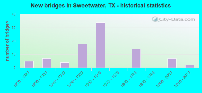
- New bridges - historical statistics
- 51920-1929
- 71930-1939
- 41940-1949
- 181950-1959
- 341960-1969
- 141980-1989
- 72000-2009
- 22010-2019
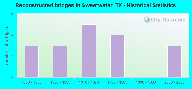
- Reconstructed bridges - Historical Statistics
- 31950-1959
- 31960-1969
- 51970-1979
- 41980-1989
- 01990-1999
- 32000-2009
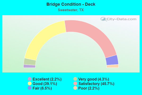
- Bridge Condition - Deck
- 2.2%Excellent
- 4.3%Very good
- 39.1%Good
- 45.7%Satisfactory
- 6.5%Fair
- 2.2%Poor
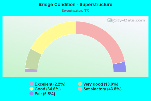
- Bridge Condition - Superstructure
- 2.2%Excellent
- 13.0%Very good
- 34.8%Good
- 43.5%Satisfactory
- 6.5%Fair
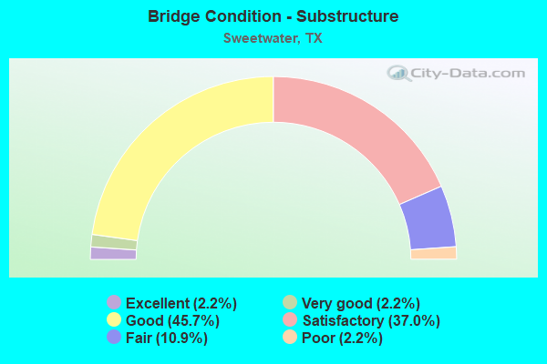
- Bridge Condition - Substructure
- 2.2%Excellent
- 2.2%Very good
- 45.7%Good
- 37.0%Satisfactory
- 10.9%Fair
- 2.2%Poor
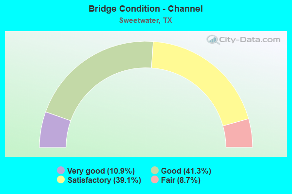
- Bridge Condition - Channel
- 10.9%Very good
- 41.3%Good
- 39.1%Satisfactory
- 8.7%Fair
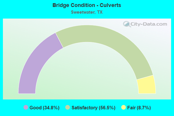
- Bridge Condition - Culverts
- 34.8%Good
- 56.5%Satisfactory
- 8.7%Fair
Find on map >> Show street view
Structure Number: 80770098302008, Location: 3.40 MI S OF FM 57 (Lat: 32.545086, Lng: -100.441625), Route carried "on" structure: State highway 419, Year Built: 1940, Year Reconstructed: 1958, Status: Open, Structure Length: 0.76m (2.49ft), Average Daily Traffic: 430 (year 2020), Truck Traffic: 15%, Average Future Daily Traffic: 630 (year 2033), Design Load: H 10, Features Intersected: DRAW
Minimum Vertical Clearance: 30+ m (98+ ft), Kilometerpoint: 32.702, Lanes on structure: 2, Owner: State Highway Agency, Approaching Roadway Width: 7.6m (24.9ft), Material/Design: Steel, Design/Construction: Stringer/Multi-beam, Number Of Spans In Main Unit: 1, Length of Maximum Span: 7.6m (24.9ft), Curb-To-Curb Width: 10.3m (33.8ft), Out-to-Out Width: 10.8m (35.4ft)
Condition: Deck: Satisfactory, Superstructure: Good, Substructure: Satisfactory, Channel: Very good, Operating Rating: 37.2 metric tons, Method Used To Determine Operating Rating: Load Factor (LF), Inventory Rating: 22.7 metric tons, Method Used To Determine Inventory Rating: Load Factor (LF), Structural Evaluation: Equal to present minimum criteria, Deck Geometry: Equal to present minimum criteria, Waterway Adequacy: Equal to present minimum criteria, Approach Roadway Alignment: High priority of corrective action, Length Of Structure Improvement: 0.76m (2.49ft), Designated Inspection Frequency: Every 24 months, Inspection Date: July 2021, Deck Structure Type: Concrete Cast-file-Place, Wearing Surface/Protective System: Wearing Surface: Bituminous
Find on map >> Show street view
Structure Number: 80770AA0354001, Location: 0.5 MI E OF SH 70 (Lat: 32.541400, Lng: -100.371181), Route carried "on" structure: County highway 134, Year Built: 2012, Status: Open, Structure Length: 2.44m (8.01ft), Average Daily Traffic: 180 (year 2016), Average Future Daily Traffic: 130 (year 2033), Design Load: HL 93, Features Intersected: ROCK CREEK
Minimum Vertical Clearance: 30+ m (98+ ft), Kilometerpoint: 0.805, Lanes on structure: 2, Owner: Town or Township Highway Agency, Approaching Roadway Width: 4.9m (16.1ft), Material/Design: Prestressed concrete, Design/Construction: Stringer/Multi-beam, Number Of Spans In Main Unit: 1, Length of Maximum Span: 24.4m (80.1ft), Curb-To-Curb Width: 7.1m (23.3ft), Out-to-Out Width: 7.9m (25.9ft)
Condition: Deck: Very good, Superstructure: Very good, Substructure: Good, Channel: Very good, Operating Rating: 54.4 metric tons, Method Used To Determine Operating Rating: Assigned ratings based on Load and Resistance Factor Design (LRFD) reported in metric tons, Inventory Rating: 32.7 metric tons, Method Used To Determine Inventory Rating: Assigned ratings based on Load and Resistance Factor Design (LRFD) reported in metric tons, Structural Evaluation: Better than present minimum criteria, Deck Geometry: Meets minimum limits, Waterway Adequacy: Superior to present desirable criteria, Approach Roadway Alignment: Equal to present desirable criteria, Length Of Structure Improvement: 3.17m (10.40ft), Designated Inspection Frequency: Every 24 months, Inspection Date: May 2020, Bridge Improvement Cost: $6,000, Roadway Improvement Cost: $2,000, Total Project Cost: $8,000, Deck Structure Type: Concrete Precast Panels
Find on map >> Show street view
Structure Number: 81770000602005, Location: 2.00 MI E OF MITCHELL C/L (Lat: 32.416586, Lng: -100.628939), Route carried "on" structure: ServiceInterstate 20, Year Built: 1925, Year Reconstructed: 1967, Status: Open, Structure Length: 2.13m (6.99ft), Average Daily Traffic: 90 (year 2013), Truck Traffic: 38%, Average Future Daily Traffic: 130 (year 2033), Design Load: H 15, Features Intersected: COTTONWOOD CREEK BRANCH
Minimum Vertical Clearance: 30+ m (98+ ft), Kilometerpoint: 3.219, Lanes on structure: 2, Owner: State Highway Agency, Approaching Roadway Width: 7.3m (24.0ft), Material/Design: Concrete, Design/Construction: Culvert, Number Of Spans In Main Unit: 15, Length of Maximum Span: 1.2m (3.9ft), Curb-To-Curb Width: 13.2m (43.3ft), Out-to-Out Width: 13.6m (44.6ft)
Condition: Channel: Good, Culverts: Satisfactory, Operating Rating: 39.9 metric tons, Method Used To Determine Operating Rating: Load Factor (LF), Inventory Rating: 23.6 metric tons, Method Used To Determine Inventory Rating: Load Factor (LF), Structural Evaluation: Equal to present minimum criteria, Deck Geometry: Superior to present desirable criteria, Waterway Adequacy: Equal to present minimum criteria, Approach Roadway Alignment: Equal to present desirable criteria, Length Of Structure Improvement: 2.10m (6.89ft), Designated Inspection Frequency: Every 24 months, Inspection Date: March 2021, Bridge Improvement Cost: $33,000, Roadway Improvement Cost: $8,000, Total Project Cost: $50,000, Deck Structure Type: Concrete Cast-file-Place
Find on map >> Show street view
Structure Number: 81770000602189, Location: 3.85 MI W of SH 70 (Lat: 32.453614, Lng: -100.464014), Route carried "on" structure: Business State highway 20, Year Built: 1960, Year Reconstructed: 1986, Status: Open, Structure Length: 12.28m (40.29ft), Average Daily Traffic: 2,520 (year 2013), Truck Traffic: 31%, Average Future Daily Traffic: 3,530 (year 2033), Design Load: H 20, Features Intersected: IH 20
Minimum Vertical Clearance: 30+ m (98+ ft), Kilometerpoint: 19.938, Lanes on structure: 2, Lanes under structure: 4, Owner: State Highway Agency, Approaching Roadway Width: 10.4m (34.1ft), Skew: 5 degrees, Material/Design: Steel continuous, Design/Construction: Stringer/Multi-beam, Number Of Spans In Main Unit: 4, Length of Maximum Span: 30.5m (100.1ft), Curb-To-Curb Width: 11.1m (36.4ft), Out-to-Out Width: 11.6m (38.1ft)
Condition: Deck: Fair, Superstructure: Satisfactory, Substructure: Fair, Operating Rating: 42.6 metric tons, Method Used To Determine Operating Rating: Load Factor (LF), Inventory Rating: 25.4 metric tons, Method Used To Determine Inventory Rating: Load Factor (LF), Structural Evaluation: Somewhat better than minimum adequacy, Deck Geometry: Equal to present minimum criteria, Underclear: Somewhat better than minimum adequacy, Approach Roadway Alignment: Equal to present minimum criteria, Length Of Structure Improvement: 12.25m (40.19ft), Designated Inspection Frequency: Every 24 months, Inspection Date: March 2021, Deck Structure Type: Concrete Cast-file-Place
Find on map >> Show street view
Structure Number: 81770000602229, Location: 11.50 MI E of Mitchell CL (Lat: 32.452242, Lng: -100.473975), Route carried "on" structure: Interstate 20, Year Built: 1960, Status: Open, Structure Length: 3.47m (11.38ft), Average Daily Traffic: 17,293 (year 2019), Truck Traffic: 33%, Average Future Daily Traffic: 15,190 (year 2033), Design Load: HS 20, Features Intersected: Loop 170 Connector
Minimum Vertical Clearance: 30+ m (98+ ft), Kilometerpoint: 18.356, Lanes on structure: 2, Lanes under structure: 2, Owner: State Highway Agency, Approaching Roadway Width: 11.6m (38.1ft), Material/Design: Concrete continuous, Design/Construction: Slab, Number Of Spans In Main Unit: 3, Length of Maximum Span: 13.7m (44.9ft), Curb-To-Curb Width: 11.7m (38.4ft), Out-to-Out Width: 12.2m (40.0ft)
Condition: Deck: Satisfactory, Superstructure: Satisfactory, Substructure: Good, Operating Rating: 53.5 metric tons, Method Used To Determine Operating Rating: Load Factor (LF), Inventory Rating: 31.7 metric tons, Method Used To Determine Inventory Rating: Load Factor (LF), Structural Evaluation: Equal to present minimum criteria, Deck Geometry: Equal to present minimum criteria, Underclear: High priority of corrective action, Approach Roadway Alignment: Equal to present desirable criteria, Designated Inspection Frequency: Every 24 months, Inspection Date: March 2021, Deck Structure Type: Concrete Cast-file-Place, Wearing Surface/Protective System: Wearing Surface: Bituminous
Find on map >> Show street view
Structure Number: 8177000060223, Location: 11.50 MI E of Mitchell CL (Lat: 32.452072, Lng: -100.473933), Route carried "on" structure: Interstate 20, Year Built: 1960, Status: Open, Structure Length: 3.47m (11.38ft), Average Daily Traffic: 17,348 (year 2019), Truck Traffic: 33%, Average Future Daily Traffic: 15,190 (year 2033), Design Load: HS 20, Features Intersected: Loop 170 Connector
Minimum Vertical Clearance: 30+ m (98+ ft), Kilometerpoint: 18.356, Lanes on structure: 2, Lanes under structure: 2, Owner: State Highway Agency, Approaching Roadway Width: 11.6m (38.1ft), Material/Design: Concrete continuous, Design/Construction: Slab, Number Of Spans In Main Unit: 3, Length of Maximum Span: 13.7m (44.9ft), Curb-To-Curb Width: 11.7m (38.4ft), Out-to-Out Width: 12.2m (40.0ft)
Condition: Deck: Satisfactory, Superstructure: Satisfactory, Substructure: Good, Operating Rating: 53.5 metric tons, Method Used To Determine Operating Rating: Load Factor (LF), Inventory Rating: 31.7 metric tons, Method Used To Determine Inventory Rating: Load Factor (LF), Structural Evaluation: Equal to present minimum criteria, Deck Geometry: Equal to present minimum criteria, Underclear: Meets minimum limits, Approach Roadway Alignment: Equal to present desirable criteria, Designated Inspection Frequency: Every 24 months, Inspection Date: March 2021, Deck Structure Type: Concrete Cast-file-Place, Wearing Surface/Protective System: Wearing Surface: Bituminous
Find on map >> Show street view
Structure Number: 81770000602232, Location: 2.60 MI W of SH 70 (Lat: 32.449792, Lng: -100.442206), Route carried "on" structure: Interstate 20, Year Built: 1960, Status: Open, Structure Length: 3.47m (11.38ft), Average Daily Traffic: 10,090 (year 2013), Truck Traffic: 34%, Average Future Daily Traffic: 14,130 (year 2033), Design Load: HS 20, Features Intersected: Hopkins Rd
Minimum Vertical Clearance: 30+ m (98+ ft), Kilometerpoint: 21.393, Lanes on structure: 2, Lanes under structure: 2, Owner: State Highway Agency, Approaching Roadway Width: 11.6m (38.1ft), Material/Design: Concrete continuous, Design/Construction: Slab, Number Of Spans In Main Unit: 3, Length of Maximum Span: 13.7m (44.9ft), Curb-To-Curb Width: 11.7m (38.4ft), Out-to-Out Width: 12.2m (40.0ft)
Condition: Deck: Satisfactory, Superstructure: Satisfactory, Substructure: Satisfactory, Operating Rating: 52.6 metric tons, Method Used To Determine Operating Rating: Load Factor (LF), Inventory Rating: 31.7 metric tons, Method Used To Determine Inventory Rating: Load Factor (LF), Structural Evaluation: Equal to present minimum criteria, Deck Geometry: Equal to present minimum criteria, Underclear: Meets minimum limits, Approach Roadway Alignment: Equal to present desirable criteria, Designated Inspection Frequency: Every 24 months, Inspection Date: March 2021, Deck Structure Type: Concrete Cast-file-Place, Wearing Surface/Protective System: Wearing Surface: Bituminous
Find on map >> Show street view
Structure Number: 81770000602233, Location: 2.60 MI W of SH 70 (Lat: 32.449614, Lng: -100.442233), Route carried "on" structure: Interstate 20, Year Built: 1960, Status: Open, Structure Length: 3.47m (11.38ft), Average Daily Traffic: 10,090 (year 2013), Truck Traffic: 34%, Average Future Daily Traffic: 14,130 (year 2033), Design Load: HS 20, Features Intersected: Hopkins Rd.
Minimum Vertical Clearance: 30+ m (98+ ft), Kilometerpoint: 21.393, Lanes on structure: 2, Lanes under structure: 2, Owner: State Highway Agency, Approaching Roadway Width: 11.6m (38.1ft), Material/Design: Concrete continuous, Design/Construction: Slab, Number Of Spans In Main Unit: 3, Length of Maximum Span: 13.7m (44.9ft), Curb-To-Curb Width: 11.7m (38.4ft), Out-to-Out Width: 12.2m (40.0ft)
Condition: Deck: Satisfactory, Superstructure: Satisfactory, Substructure: Satisfactory, Operating Rating: 52.6 metric tons, Method Used To Determine Operating Rating: Load Factor (LF), Inventory Rating: 31.7 metric tons, Method Used To Determine Inventory Rating: Load Factor (LF), Structural Evaluation: Equal to present minimum criteria, Deck Geometry: Equal to present minimum criteria, Underclear: Meets minimum limits, Approach Roadway Alignment: Equal to present desirable criteria, Designated Inspection Frequency: Every 24 months, Inspection Date: March 2021, Deck Structure Type: Concrete Cast-file-Place, Wearing Surface/Protective System: Wearing Surface: Bituminous
Find on map >> Show street view
Structure Number: 81770000602234, Location: 2.10 MI W OF SH 70 (Lat: 32.449267, Lng: -100.436142), Route carried "on" structure: Interstate 20, Year Built: 1960, Status: Open, Structure Length: 0.76m (2.49ft), Average Daily Traffic: 20,180 (year 2013), Truck Traffic: 34%, Average Future Daily Traffic: 28,260 (year 2033), Features Intersected: DRAW
Minimum Vertical Clearance: 30+ m (98+ ft), Kilometerpoint: 21.987, Lanes on structure: 5, Owner: State Highway Agency, Approaching Roadway Width: 23.2m (76.1ft), Skew: 23 degrees, Material/Design: Concrete, Design/Construction: Culvert, Number Of Spans In Main Unit: 2, Length of Maximum Span: 3.0m (9.8ft)
Condition: Channel: Satisfactory, Culverts: Satisfactory, Operating Rating: 32.7 metric tons, Method Used To Determine Operating Rating: Field evaluation and documented engineering judgment, Inventory Rating: 24.5 metric tons, Method Used To Determine Inventory Rating: Field evaluation and documented engineering judgment, Structural Evaluation: Equal to present minimum criteria, Waterway Adequacy: Equal to present minimum criteria, Approach Roadway Alignment: Equal to present desirable criteria, Designated Inspection Frequency: Every 24 months, Inspection Date: March 2021
Find on map >> Show street view
Structure Number: 81770000602235, Location: 1.30 MI W of SH 70 (Lat: 32.448036, Lng: -100.420436), Route carried "on" structure: Interstate 20, Year Built: 1960, Year Reconstructed: 2007, Status: Open, Structure Length: 7.68m (25.20ft), Average Daily Traffic: 10,090 (year 2013), Truck Traffic: 34%, Average Future Daily Traffic: 14,130 (year 2033), Design Load: HS 20, Features Intersected: BNSF RR / CR 217
Minimum Vertical Clearance: 30+ m (98+ ft), Kilometerpoint: 23.447, Lanes on structure: 2, Lanes under structure: 2, Owner: State Highway Agency, Approaching Roadway Width: 11.6m (38.1ft), Skew: 2 degrees, Material/Design: Steel continuous, Design/Construction: Stringer/Multi-beam, Number Of Spans In Main Unit: 4, Length of Maximum Span: 19.8m (65.0ft), Curb-To-Curb Width: 11.6m (38.1ft), Out-to-Out Width: 12.2m (40.0ft)
Condition: Deck: Good, Superstructure: Good, Substructure: Good, Operating Rating: 58.0 metric tons, Method Used To Determine Operating Rating: Load Factor (LF), Inventory Rating: 34.5 metric tons, Method Used To Determine Inventory Rating: Load Factor (LF), Structural Evaluation: Better than present minimum criteria, Deck Geometry: Equal to present minimum criteria, Underclear: Superior to present desirable criteria, Approach Roadway Alignment: Equal to present desirable criteria, Length Of Structure Improvement: 7.62m (25.00ft), Designated Inspection Frequency: Every 24 months, Inspection Date: March 2021, Deck Structure Type: Concrete Cast-file-Place, Wearing Surface/Protective System: Deck Protection: Epoxy Coated Reinforcing
Find on map >> Show street view
Structure Number: 81770000602236, Location: 1.30 MI W of SH 70 (Lat: 32.448197, Lng: -100.420222), Route carried "on" structure: Interstate 20, Year Built: 1960, Year Reconstructed: 2007, Status: Open, Structure Length: 7.68m (25.20ft), Average Daily Traffic: 10,090 (year 2013), Truck Traffic: 34%, Average Future Daily Traffic: 14,130 (year 2033), Design Load: HS 20, Features Intersected: BNSF RR/CR 217
Minimum Vertical Clearance: 30+ m (98+ ft), Kilometerpoint: 23.456, Lanes on structure: 2, Lanes under structure: 2, Owner: State Highway Agency, Approaching Roadway Width: 11.6m (38.1ft), Skew: 2 degrees, Material/Design: Steel continuous, Design/Construction: Stringer/Multi-beam, Number Of Spans In Main Unit: 4, Length of Maximum Span: 19.8m (65.0ft), Curb-To-Curb Width: 11.6m (38.1ft), Out-to-Out Width: 12.2m (40.0ft)
Condition: Deck: Good, Superstructure: Very good, Substructure: Satisfactory, Operating Rating: 58.0 metric tons, Method Used To Determine Operating Rating: Load Factor (LF), Inventory Rating: 34.5 metric tons, Method Used To Determine Inventory Rating: Load Factor (LF), Structural Evaluation: Equal to present minimum criteria, Deck Geometry: Equal to present minimum criteria, Underclear: Better than present minimum criteria, Approach Roadway Alignment: Equal to present desirable criteria, Length Of Structure Improvement: 7.62m (25.00ft), Designated Inspection Frequency: Every 24 months, Inspection Date: March 2021, Deck Structure Type: Concrete Cast-file-Place, Wearing Surface/Protective System: Deck Protection: Epoxy Coated Reinforcing
Find on map >> Show street view
Structure Number: 81770000602237, Location: 1.00 MI W OF SH 70 (Lat: 32.447789, Lng: -100.415439), Route carried "on" structure: County highway , Year Built: 1960, Status: Closed, Structure Length: 9.14m (29.99ft), Average Daily Traffic: 381 (year 2020), Average Future Daily Traffic: 400 (year 2033), Features Intersected: IH 20, Facility Carried by Structure: Robert Lee St
Minimum Vertical Clearance: 30+ m (98+ ft), Kilometerpoint: 7.081, Lanes on structure: 2, Lanes under structure: 8, Owner: State Highway Agency, Approaching Roadway Width: 7.9m (25.9ft), Skew: 1 degrees, Material/Design: Concrete continuous, Design/Construction: Tee Beam, Number Of Spans In Main Unit: 4, Number Of Approach Spans: 2, Length of Maximum Span: 19.8m (65.0ft), Curb-To-Curb Width: 7.8m (25.6ft), Out-to-Out Width: 9.2m (30.2ft)
Condition: Deck: Satisfactory, Superstructure: Satisfactory, Substructure: Satisfactory, Operating Rating: 49.9 metric tons, Method Used To Determine Operating Rating: Load Factor (LF), Inventory Rating: 29.0 metric tons, Method Used To Determine Inventory Rating: Load Factor (LF), Structural Evaluation: Equal to present minimum criteria, Deck Geometry: Somewhat better than minimum adequacy, Underclear: Somewhat better than minimum adequacy, Approach Roadway Alignment: Equal to present desirable criteria, Length Of Structure Improvement: 9.14m (29.99ft), Designated Inspection Frequency: Every 24 months, Inspection Date: March 2021, Bridge Improvement Cost: $16,000, Roadway Improvement Cost: $4,000, Total Project Cost: $20,000, Deck Structure Type: Concrete Cast-file-Place, Wearing Surface/Protective System: Wearing Surface: Bituminous
Find on map >> Show street view
Structure Number: 81770000602238, Location: 1.00 MI W OF SH 70 (Lat: 32.447778, Lng: -100.415650), Route carried "on" structure: Interstate 20, Year Built: 1960, Year Reconstructed: 1980, Status: Open, Structure Length: 0.70m (2.30ft), Average Daily Traffic: 20,180 (year 2013), Truck Traffic: 34%, Average Future Daily Traffic: 28,260 (year 2033), Features Intersected: DRAW
Minimum Vertical Clearance: 30+ m (98+ ft), Kilometerpoint: 23.916, Lanes on structure: 8, Owner: State Highway Agency, Approaching Roadway Width: 37.8m (124.0ft), Skew: 21 degrees, Material/Design: Concrete, Design/Construction: Culvert, Number Of Spans In Main Unit: 4, Length of Maximum Span: 1.5m (4.9ft), Curb-To-Curb Width: 37.8m (124.0ft), Out-to-Out Width: 71.0m (232.9ft)
Condition: Channel: Satisfactory, Culverts: Satisfactory, Operating Rating: 32.7 metric tons, Method Used To Determine Operating Rating: Field evaluation and documented engineering judgment, Inventory Rating: 24.5 metric tons, Method Used To Determine Inventory Rating: Field evaluation and documented engineering judgment, Structural Evaluation: Equal to present minimum criteria, Deck Geometry: Superior to present desirable criteria, Waterway Adequacy: Equal to present minimum criteria, Approach Roadway Alignment: Equal to present desirable criteria, Length Of Structure Improvement: 0.70m (2.30ft), Designated Inspection Frequency: Every 24 months, Inspection Date: March 2021, Bridge Improvement Cost: $45,000, Roadway Improvement Cost: $22,000, Total Project Cost: $67,000, Deck Structure Type: Concrete Cast-file-Place, Wearing Surface/Protective System: Wearing Surface: Bituminous
Find on map >> Show street view
Structure Number: 81770000602315, Location: 1.00 MI W OF SH 70 (Lat: 32.449336, Lng: -100.416078), Route carried "on" structure: ServiceInterstate 20, Year Built: 1986, Status: Open, Structure Length: 0.67m (2.20ft), Average Daily Traffic: 360 (year 2013), Truck Traffic: 35%, Average Future Daily Traffic: 500 (year 2033), Design Load: HS 20, Features Intersected: DRAW
Minimum Vertical Clearance: 30+ m (98+ ft), Kilometerpoint: 23.913, Lanes on structure: 2, Owner: State Highway Agency, Approaching Roadway Width: 8.5m (27.9ft), Material/Design: Concrete, Design/Construction: Culvert, Number Of Spans In Main Unit: 4, Length of Maximum Span: 1.5m (4.9ft), Curb-To-Curb Width: 9.1m (29.9ft), Out-to-Out Width: 9.5m (31.2ft)
Condition: Channel: Good, Culverts: Fair, Operating Rating: 39.9 metric tons, Method Used To Determine Operating Rating: Load Factor (LF), Inventory Rating: 23.6 metric tons, Method Used To Determine Inventory Rating: Load Factor (LF), Structural Evaluation: Somewhat better than minimum adequacy, Deck Geometry: Equal to present minimum criteria, Waterway Adequacy: Equal to present minimum criteria, Approach Roadway Alignment: Better than present minimum criteria, Designated Inspection Frequency: Every 24 months, Inspection Date: March 2021, Deck Structure Type: Concrete Cast-file-Place, Wearing Surface/Protective System: Wearing Surface: Bituminous
Find on map >> Show street view
Structure Number: 81770000602316, Location: 1.00 MI W OF SH 70 (Lat: 32.445900, Lng: -100.415131), Route carried "on" structure: ServiceInterstate 20, Year Built: 1986, Status: Open, Structure Length: 0.67m (2.20ft), Average Daily Traffic: 270 (year 2013), Truck Traffic: 35%, Average Future Daily Traffic: 380 (year 2033), Design Load: HS 20, Features Intersected: DRAW
Minimum Vertical Clearance: 30+ m (98+ ft), Kilometerpoint: 23.913, Lanes on structure: 2, Owner: State Highway Agency, Approaching Roadway Width: 9.8m (32.2ft), Material/Design: Concrete, Design/Construction: Culvert, Number Of Spans In Main Unit: 4, Length of Maximum Span: 1.5m (4.9ft), Curb-To-Curb Width: 10.4m (34.1ft), Out-to-Out Width: 10.8m (35.4ft)
Condition: Channel: Good, Culverts: Satisfactory, Operating Rating: 39.9 metric tons, Method Used To Determine Operating Rating: Load Factor (LF), Inventory Rating: 23.6 metric tons, Method Used To Determine Inventory Rating: Load Factor (LF), Structural Evaluation: Equal to present minimum criteria, Deck Geometry: Better than present minimum criteria, Waterway Adequacy: Equal to present minimum criteria, Approach Roadway Alignment: Better than present minimum criteria, Designated Inspection Frequency: Every 24 months, Inspection Date: March 2021, Deck Structure Type: Concrete Cast-file-Place, Wearing Surface/Protective System: Wearing Surface: Bituminous
Find on map >> Show street view
Structure Number: 81770000603011, Location: 0.85 MI W OF FM 1856 (Lat: 32.485417, Lng: -100.351833), Route carried "on" structure: Interstate 20, Year Built: 1925, Year Reconstructed: 1981, Status: Open, Structure Length: 5.97m (19.59ft), Average Daily Traffic: 14,379 (year 2019), Truck Traffic: 41%, Average Future Daily Traffic: 13,540 (year 2033), Design Load: H 15, Features Intersected: Sweetwater Creek
Minimum Vertical Clearance: 30+ m (98+ ft), Kilometerpoint: 31.831, Lanes on structure: 2, Owner: State Highway Agency, Approaching Roadway Width: 11.6m (38.1ft), Material/Design: Concrete, Design/Construction: Tee Beam, Number Of Spans In Main Unit: 1, Number Of Approach Spans: 7, Length of Maximum Span: 11.9m (39.0ft), Curb-To-Curb Width: 11.5m (37.7ft), Out-to-Out Width: 12.3m (40.4ft)
Condition: Deck: Satisfactory, Superstructure: Satisfactory, Substructure: Fair, Channel: Fair, Operating Rating: 59.9 metric tons, Method Used To Determine Operating Rating: Load Factor (LF), Inventory Rating: 35.4 metric tons, Method Used To Determine Inventory Rating: Load Factor (LF), Structural Evaluation: Somewhat better than minimum adequacy, Deck Geometry: Somewhat better than minimum adequacy, Waterway Adequacy: Superior to present desirable criteria, Approach Roadway Alignment: Equal to present desirable criteria, Designated Inspection Frequency: Every 24 months, Inspection Date: March 2021, Deck Structure Type: Concrete Cast-file-Place, Wearing Surface/Protective System: Wearing Surface: Bituminous
Find on map >> Show street view
Structure Number: 81770000603021, Location: 6.2 Mi. E of US 84 (Lat: 32.449922, Lng: -100.398742), Route carried "on" structure: Interstate 20, Year Built: 2007, Status: Open, Structure Length: 6.25m (20.51ft), Average Daily Traffic: 16,464 (year 2019), Truck Traffic: 35%, Average Future Daily Traffic: 14,110 (year 2033), Design Load: HL 93, Features Intersected: SH 70
Minimum Vertical Clearance: 30+ m (98+ ft), Kilometerpoint: 25.682, Lanes on structure: 2, Lanes under structure: 4, Owner: State Highway Agency, Approaching Roadway Width: 11.6m (38.1ft), Material/Design: Prestressed concrete, Design/Construction: Stringer/Multi-beam, Number Of Spans In Main Unit: 3, Length of Maximum Span: 21.3m (69.9ft), Curb-To-Curb Width: 11.6m (38.1ft), Out-to-Out Width: 12.2m (40.0ft)
Condition: Deck: Good, Superstructure: Very good, Substructure: Good, Operating Rating: 54.4 metric tons, Method Used To Determine Operating Rating: Assigned ratings based on Load and Resistance Factor Design (LRFD) reported in metric tons, Inventory Rating: 32.7 metric tons, Method Used To Determine Inventory Rating: Assigned ratings based on Load and Resistance Factor Design (LRFD) reported in metric tons, Structural Evaluation: Better than present minimum criteria, Deck Geometry: Equal to present minimum criteria, Underclear: High priority of corrective action, Approach Roadway Alignment: Equal to present desirable criteria, Designated Inspection Frequency: Every 24 months, Inspection Date: March 2021, Deck Structure Type: Concrete Cast-file-Place
Find on map >> Show street view
Structure Number: 81770000603048, Location: 6.2 Mi. E of US 84 (Lat: 32.450322, Lng: -100.398231), Route carried "on" structure: Interstate 20, Year Built: 2007, Status: Open, Structure Length: 6.25m (20.51ft), Average Daily Traffic: 12,957 (year 2019), Truck Traffic: 35%, Average Future Daily Traffic: 14,110 (year 2033), Design Load: HL 93, Features Intersected: SH 70
Minimum Vertical Clearance: 30+ m (98+ ft), Kilometerpoint: 25.682, Lanes on structure: 2, Lanes under structure: 4, Owner: State Highway Agency, Approaching Roadway Width: 11.6m (38.1ft), Material/Design: Prestressed concrete, Design/Construction: Stringer/Multi-beam, Number Of Spans In Main Unit: 3, Length of Maximum Span: 21.3m (69.9ft), Curb-To-Curb Width: 11.6m (38.1ft), Out-to-Out Width: 12.2m (40.0ft)
Condition: Deck: Good, Superstructure: Very good, Substructure: Good, Operating Rating: 54.4 metric tons, Method Used To Determine Operating Rating: Assigned ratings based on Load and Resistance Factor Design (LRFD) reported in metric tons, Inventory Rating: 32.7 metric tons, Method Used To Determine Inventory Rating: Assigned ratings based on Load and Resistance Factor Design (LRFD) reported in metric tons, Structural Evaluation: Better than present minimum criteria, Deck Geometry: Equal to present minimum criteria, Underclear: High priority of corrective action, Approach Roadway Alignment: Equal to present desirable criteria, Designated Inspection Frequency: Every 24 months, Inspection Date: March 2021, Deck Structure Type: Concrete Cast-file-Place
Find on map >> Show street view
Structure Number: 81770000603063, Location: 0.85 MI W OF FM 1856 (Lat: 32.485211, Lng: -100.351936), Route carried "on" structure: Interstate 20, Year Built: 1954, Year Reconstructed: 1981, Status: Open, Structure Length: 6.46m (21.19ft), Average Daily Traffic: 15,615 (year 2019), Truck Traffic: 41%, Average Future Daily Traffic: 13,540 (year 2033), Design Load: HS 20, Features Intersected: Sweetwater Creek
Minimum Vertical Clearance: 30+ m (98+ ft), Kilometerpoint: 31.820, Lanes on structure: 2, Owner: State Highway Agency, Approaching Roadway Width: 11.6m (38.1ft), Material/Design: Concrete, Design/Construction: Stringer/Multi-beam, Number Of Spans In Main Unit: 7, Length of Maximum Span: 9.1m (29.9ft), Curb-To-Curb Width: 11.5m (37.7ft), Out-to-Out Width: 12.2m (40.0ft)
Condition: Deck: Satisfactory, Superstructure: Satisfactory, Substructure: Fair, Channel: Satisfactory, Operating Rating: 68.0 metric tons, Method Used To Determine Operating Rating: Load Factor (LF), Inventory Rating: 40.8 metric tons, Method Used To Determine Inventory Rating: Load Factor (LF), Structural Evaluation: Somewhat better than minimum adequacy, Deck Geometry: Somewhat better than minimum adequacy, Waterway Adequacy: Equal to present minimum criteria, Approach Roadway Alignment: Equal to present desirable criteria, Designated Inspection Frequency: Every 24 months, Inspection Date: March 2021, Deck Structure Type: Concrete Cast-file-Place, Wearing Surface/Protective System: Wearing Surface: Bituminous
Find on map >> Show street view
Structure Number: 8177000060309, Location: 4.7 Mi E of SH 70 (Lat: 32.488236, Lng: -100.337258), Route carried "on" structure: Interstate 20, Year Built: 1957, Status: Open, Structure Length: 3.47m (11.38ft), Average Daily Traffic: 14,379 (year 2019), Truck Traffic: 41%, Average Future Daily Traffic: 13,540 (year 2033), Design Load: HS 20, Features Intersected: FM 1856
Minimum Vertical Clearance: 30+ m (98+ ft), Kilometerpoint: 33.252, Lanes on structure: 2, Lanes under structure: 2, Owner: State Highway Agency, Approaching Roadway Width: 11.3m (37.1ft), Material/Design: Concrete continuous, Design/Construction: Slab, Number Of Spans In Main Unit: 3, Length of Maximum Span: 13.7m (44.9ft), Curb-To-Curb Width: 11.4m (37.4ft), Out-to-Out Width: 12.0m (39.4ft)
Condition: Deck: Good, Superstructure: Good, Substructure: Good, Operating Rating: 39.9 metric tons, Method Used To Determine Operating Rating: Load Factor (LF), Inventory Rating: 23.6 metric tons, Method Used To Determine Inventory Rating: Load Factor (LF), Structural Evaluation: Somewhat better than minimum adequacy, Deck Geometry: Somewhat better than minimum adequacy, Underclear: Equal to present minimum criteria, Approach Roadway Alignment: Equal to present desirable criteria, Designated Inspection Frequency: Every 24 months, Inspection Date: March 2021, Deck Structure Type: Concrete Cast-file-Place, Wearing Surface/Protective System: Wearing Surface: Bituminous
Find on map >> Show street view
Structure Number: 81770000603091, Location: 4.7 Mi E of SH 70 (Lat: 32.488061, Lng: -100.337211), Route carried "on" structure: Interstate 20, Year Built: 1957, Status: Open, Structure Length: 3.47m (11.38ft), Average Daily Traffic: 15,763 (year 2019), Truck Traffic: 41%, Average Future Daily Traffic: 13,540 (year 2033), Design Load: HS 20, Features Intersected: FM 1856
Minimum Vertical Clearance: 30+ m (98+ ft), Kilometerpoint: 33.252, Lanes on structure: 2, Lanes under structure: 2, Owner: State Highway Agency, Approaching Roadway Width: 11.3m (37.1ft), Material/Design: Concrete continuous, Design/Construction: Slab, Number Of Spans In Main Unit: 3, Length of Maximum Span: 13.7m (44.9ft), Curb-To-Curb Width: 11.4m (37.4ft), Out-to-Out Width: 12.0m (39.4ft)
Condition: Deck: Satisfactory, Superstructure: Satisfactory, Substructure: Good, Operating Rating: 39.9 metric tons, Method Used To Determine Operating Rating: Load Factor (LF), Inventory Rating: 23.6 metric tons, Method Used To Determine Inventory Rating: Load Factor (LF), Structural Evaluation: Somewhat better than minimum adequacy, Deck Geometry: Somewhat better than minimum adequacy, Underclear: Equal to present minimum criteria, Approach Roadway Alignment: Equal to present desirable criteria, Designated Inspection Frequency: Every 24 months, Inspection Date: March 2021, Deck Structure Type: Concrete Cast-file-Place, Wearing Surface/Protective System: Wearing Surface: Bituminous
Find on map >> Show street view
Structure Number: 81770000603162, Location: 0.85 MI W OF FM 1856 (Lat: 32.485592, Lng: -100.351739), Route carried "on" structure: ServiceInterstate 20, Year Built: 1959, Status: Open, Structure Length: 2.29m (7.51ft), Average Daily Traffic: 500 (year 2013), Truck Traffic: 35%, Average Future Daily Traffic: 710 (year 2033), Design Load: H 20, Features Intersected: Sweetwater Creek
Minimum Vertical Clearance: 30+ m (98+ ft), Kilometerpoint: 31.868, Lanes on structure: 2, Owner: State Highway Agency, Approaching Roadway Width: 7.0m (23.0ft), Material/Design: Concrete, Design/Construction: Slab, Number Of Spans In Main Unit: 3, Length of Maximum Span: 7.6m (24.9ft), Curb-To-Curb Width: 7.9m (25.9ft), Out-to-Out Width: 8.3m (27.2ft)
Condition: Deck: Good, Superstructure: Good, Substructure: Good, Channel: Good, Operating Rating: 49.9 metric tons, Method Used To Determine Operating Rating: Load Factor (LF), Inventory Rating: 29.9 metric tons, Method Used To Determine Inventory Rating: Load Factor (LF), Structural Evaluation: Better than present minimum criteria, Deck Geometry: Somewhat better than minimum adequacy, Waterway Adequacy: Meets minimum limits, Approach Roadway Alignment: Equal to present desirable criteria, Length Of Structure Improvement: 2.29m (7.51ft), Designated Inspection Frequency: Every 24 months, Inspection Date: March 2021, Bridge Improvement Cost: $4,000, Roadway Improvement Cost: $1,000, Total Project Cost: $5,000, Deck Structure Type: Concrete Cast-file-Place, Wearing Surface/Protective System: Wearing Surface: Bituminous
Find on map >> Show street view
Structure Number: 81770000603163, Location: 0.85 MI W OF FM 1856 (Lat: 32.485058, Lng: -100.351833), Route carried "on" structure: ServiceInterstate 20, Year Built: 1959, Status: Open, Structure Length: 2.29m (7.51ft), Average Daily Traffic: 500 (year 2013), Truck Traffic: 34%, Average Future Daily Traffic: 710 (year 2033), Design Load: H 20, Features Intersected: Sweetwater Creek
Minimum Vertical Clearance: 30+ m (98+ ft), Kilometerpoint: 31.839, Lanes on structure: 2, Owner: State Highway Agency, Approaching Roadway Width: 6.7m (22.0ft), Material/Design: Concrete, Design/Construction: Slab, Number Of Spans In Main Unit: 3, Length of Maximum Span: 7.6m (24.9ft), Curb-To-Curb Width: 7.8m (25.6ft), Out-to-Out Width: 8.3m (27.2ft)
Condition: Deck: Good, Superstructure: Good, Substructure: Good, Channel: Fair, Operating Rating: 50.8 metric tons, Method Used To Determine Operating Rating: Load Factor (LF), Inventory Rating: 30.8 metric tons, Method Used To Determine Inventory Rating: Load Factor (LF), Structural Evaluation: Better than present minimum criteria, Deck Geometry: Meets minimum limits, Waterway Adequacy: Meets minimum limits, Approach Roadway Alignment: Equal to present desirable criteria, Length Of Structure Improvement: 2.29m (7.51ft), Designated Inspection Frequency: Every 24 months, Inspection Date: March 2021, Bridge Improvement Cost: $4,000, Roadway Improvement Cost: $1,000, Total Project Cost: $5,000, Deck Structure Type: Concrete Cast-file-Place, Wearing Surface/Protective System: Wearing Surface: Bituminous
Find on map >> Show street view
Structure Number: 81770000603164, Location: 9.25 MI W OF TAYLOR C/L (Lat: 32.494147, Lng: -100.302106), Route carried "on" structure: County highway , Year Built: 1959, Status: Open, Structure Length: 5.79m (19.00ft), Average Daily Traffic: 140 (year 2013), Average Future Daily Traffic: 145 (year 2033), Design Load: H 20, Features Intersected: IH 20, Facility Carried by Structure: Eskota Rd
Minimum Vertical Clearance: 30+ m (98+ ft), Kilometerpoint: 0.002, Lanes on structure: 2, Lanes under structure: 4, Owner: State Highway Agency, Approaching Roadway Width: 7.6m (24.9ft), Material/Design: Prestressed concrete, Design/Construction: Stringer/Multi-beam, Number Of Spans In Main Unit: 2, Number Of Approach Spans: 2, Length of Maximum Span: 17.7m (58.1ft), Curb-To-Curb Width: 7.8m (25.6ft), Out-to-Out Width: 8.9m (29.2ft)
Condition: Deck: Satisfactory, Superstructure: Satisfactory, Substructure: Satisfactory, Operating Rating: 68.0 metric tons, Method Used To Determine Operating Rating: Load Factor (LF), Inventory Rating: 35.4 metric tons, Method Used To Determine Inventory Rating: Load Factor (LF), Structural Evaluation: Equal to present minimum criteria, Deck Geometry: Somewhat better than minimum adequacy, Underclear: High priority of corrective action, Approach Roadway Alignment: Equal to present desirable criteria, Length Of Structure Improvement: 5.79m (19.00ft), Designated Inspection Frequency: Every 24 months, Inspection Date: March 2021, Bridge Improvement Cost: $99,000, Roadway Improvement Cost: $25,000, Total Project Cost: $124,000, Deck Structure Type: Concrete Cast-file-Place, Wearing Surface/Protective System: Wearing Surface: Bituminous
Find on map >> Show street view
Structure Number: 8177000060319, Location: 1.60 MI W OF FM 1856 (Lat: 32.482314, Lng: -100.364681), Route carried "on" structure: Ramp State highway 70, Year Built: 1961, Status: Open, Structure Length: 5.94m (19.49ft), Average Daily Traffic: 5,510 (year 2013), Truck Traffic: 15%, Average Future Daily Traffic: 7,710 (year 2033), Design Load: H 20, Features Intersected: IH 20 WB
Minimum Vertical Clearance: 30+ m (98+ ft), Kilometerpoint: 30.254, Lanes on structure: 1, Lanes under structure: 2, Owner: State Highway Agency, Approaching Roadway Width: 8.2m (26.9ft), Skew: 4 degrees, Material/Design: Steel continuous, Design/Construction: Stringer/Multi-beam, Number Of Spans In Main Unit: 3, Length of Maximum Span: 19.8m (65.0ft), Curb-To-Curb Width: 8.1m (26.6ft), Out-to-Out Width: 9.5m (31.2ft)
Condition: Deck: Poor, Superstructure: Satisfactory, Substructure: Fair, Operating Rating: 41.7 metric tons, Method Used To Determine Operating Rating: Load Factor (LF), Inventory Rating: 25.4 metric tons, Method Used To Determine Inventory Rating: Load Factor (LF), Structural Evaluation: Somewhat better than minimum adequacy, Deck Geometry: Superior to present desirable criteria, Underclear: Meets minimum limits, Approach Roadway Alignment: Equal to present desirable criteria, Length Of Structure Improvement: 5.94m (19.49ft), Designated Inspection Frequency: Every 24 months, Inspection Date: March 2021, Bridge Improvement Cost: $11,000, Roadway Improvement Cost: $3,000, Total Project Cost: $14,000, Deck Structure Type: Concrete Cast-file-Place, Wearing Surface/Protective System: Wearing Surface: Bituminous
Find on map >> Show street view
Structure Number: 81770000603257, Location: 1.40 MI NE OF BUS 70 (Lat: 32.464167, Lng: -100.382978), Route carried "on" structure: Interstate 20, Year Built: 1961, Status: Open, Structure Length: 1.65m (5.41ft), Average Daily Traffic: 24,170 (year 2020), Truck Traffic: 33%, Average Future Daily Traffic: 23,210 (year 2033), Design Load: HS 20, Features Intersected: TOWN CREEK
Minimum Vertical Clearance: 30+ m (98+ ft), Kilometerpoint: 27.958, Lanes on structure: 4, Owner: State Highway Agency, Approaching Roadway Width: 23.2m (76.1ft), Skew: 20 degrees, Material/Design: Concrete, Design/Construction: Culvert, Number Of Spans In Main Unit: 5, Length of Maximum Span: 3.0m (9.8ft)
Condition: Channel: Satisfactory, Culverts: Fair, Operating Rating: 32.7 metric tons, Method Used To Determine Operating Rating: Field evaluation and documented engineering judgment, Inventory Rating: 24.5 metric tons, Method Used To Determine Inventory Rating: Field evaluation and documented engineering judgment, Structural Evaluation: Somewhat better than minimum adequacy, Waterway Adequacy: Equal to present desirable criteria, Approach Roadway Alignment: Equal to present desirable criteria, Designated Inspection Frequency: Every 24 months, Inspection Date: March 2021
Find on map >> Show street view
Structure Number: 81770000603258, Location: 1.45 MI NE OF BUS 70 (Lat: 32.464900, Lng: -100.382450), Route carried "on" structure: Interstate 20, Year Built: 1961, Status: Open, Structure Length: 3.47m (11.38ft), Average Daily Traffic: 12,957 (year 2019), Truck Traffic: 33%, Average Future Daily Traffic: 11,600 (year 2033), Design Load: HS 20, Features Intersected: Alabama Ave
Minimum Vertical Clearance: 30+ m (98+ ft), Kilometerpoint: 28.033, Lanes on structure: 2, Lanes under structure: 2, Owner: State Highway Agency, Approaching Roadway Width: 11.6m (38.1ft), Material/Design: Concrete continuous, Design/Construction: Slab, Number Of Spans In Main Unit: 3, Length of Maximum Span: 13.7m (44.9ft), Curb-To-Curb Width: 11.7m (38.4ft), Out-to-Out Width: 12.2m (40.0ft)
Condition: Deck: Satisfactory, Superstructure: Satisfactory, Substructure: Good, Operating Rating: 41.7 metric tons, Method Used To Determine Operating Rating: Load Factor (LF), Inventory Rating: 24.5 metric tons, Method Used To Determine Inventory Rating: Load Factor (LF), Structural Evaluation: Equal to present minimum criteria, Deck Geometry: Equal to present minimum criteria, Underclear: Somewhat better than minimum adequacy, Approach Roadway Alignment: Equal to present desirable criteria, Designated Inspection Frequency: Every 24 months, Inspection Date: March 2021, Deck Structure Type: Concrete Cast-file-Place, Wearing Surface/Protective System: Wearing Surface: Bituminous
Find on map >> Show street view
Structure Number: 81770000603259, Location: 1.45 MI NE OF BUS 70 (Lat: 32.464778, Lng: -100.382292), Route carried "on" structure: Interstate 20, Year Built: 1961, Status: Open, Structure Length: 3.47m (11.38ft), Average Daily Traffic: 15,411 (year 2019), Truck Traffic: 33%, Average Future Daily Traffic: 11,600 (year 2033), Design Load: HS 20, Features Intersected: Alabama Ave
Minimum Vertical Clearance: 30+ m (98+ ft), Kilometerpoint: 28.033, Lanes on structure: 2, Lanes under structure: 2, Owner: State Highway Agency, Approaching Roadway Width: 11.6m (38.1ft), Material/Design: Concrete continuous, Design/Construction: Slab, Number Of Spans In Main Unit: 3, Length of Maximum Span: 13.7m (44.9ft), Curb-To-Curb Width: 11.7m (38.4ft), Out-to-Out Width: 12.2m (40.0ft)
Condition: Deck: Satisfactory, Superstructure: Satisfactory, Substructure: Good, Operating Rating: 56.2 metric tons, Method Used To Determine Operating Rating: Load Factor (LF), Inventory Rating: 33.6 metric tons, Method Used To Determine Inventory Rating: Load Factor (LF), Structural Evaluation: Equal to present minimum criteria, Deck Geometry: Equal to present minimum criteria, Underclear: Somewhat better than minimum adequacy, Approach Roadway Alignment: Equal to present desirable criteria, Designated Inspection Frequency: Every 24 months, Inspection Date: March 2021, Deck Structure Type: Concrete Cast-file-Place, Wearing Surface/Protective System: Wearing Surface: Bituminous
Find on map >> Show street view
Structure Number: 8177000060326, Location: 2.70 MI NE OF BUS 70 (Lat: 32.478567, Lng: -100.368644), Route carried "on" structure: Interstate 20, Year Built: 1961, Year Reconstructed: 1979, Status: Open, Structure Length: 1.22m (4.00ft), Average Daily Traffic: 24,170 (year 2020), Truck Traffic: 33%, Average Future Daily Traffic: 23,210 (year 2033), Design Load: HS 20, Features Intersected: DRAW
Minimum Vertical Clearance: 30+ m (98+ ft), Kilometerpoint: 30.048, Lanes on structure: 4, Owner: State Highway Agency, Approaching Roadway Width: 24.7m (81.0ft), Skew: 23 degrees, Material/Design: Concrete, Design/Construction: Culvert, Number Of Spans In Main Unit: 4, Length of Maximum Span: 2.7m (8.9ft)
Condition: Channel: Good, Culverts: Satisfactory, Operating Rating: 39.9 metric tons, Method Used To Determine Operating Rating: Load Factor (LF), Inventory Rating: 23.6 metric tons, Method Used To Determine Inventory Rating: Load Factor (LF), Structural Evaluation: Somewhat better than minimum adequacy, Waterway Adequacy: Equal to present minimum criteria, Approach Roadway Alignment: Equal to present desirable criteria, Designated Inspection Frequency: Every 24 months, Inspection Date: March 2021
Find on map >> Show street view
Structure Number: 81770000603267, Location: 1.00 MI NE OF BUS 70 (Lat: 32.458967, Lng: -100.386608), Route carried "on" structure: Interstate 20, Year Built: 1961, Year Reconstructed: 1979, Status: Open, Structure Length: 0.76m (2.49ft), Average Daily Traffic: 24,170 (year 2020), Truck Traffic: 33%, Average Future Daily Traffic: 23,210 (year 2033), Features Intersected: DRAW
Minimum Vertical Clearance: 30+ m (98+ ft), Kilometerpoint: 27.286, Lanes on structure: 7, Owner: State Highway Agency, Approaching Roadway Width: 33.5m (109.9ft), Skew: 24 degrees, Material/Design: Concrete, Design/Construction: Culvert, Number Of Spans In Main Unit: 2, Length of Maximum Span: 2.4m (7.9ft)
Condition: Channel: Satisfactory, Culverts: Satisfactory, Operating Rating: 32.7 metric tons, Method Used To Determine Operating Rating: Field evaluation and documented engineering judgment, Inventory Rating: 24.5 metric tons, Method Used To Determine Inventory Rating: Field evaluation and documented engineering judgment, Structural Evaluation: Equal to present minimum criteria, Waterway Adequacy: Equal to present minimum criteria, Approach Roadway Alignment: Equal to present desirable criteria, Designated Inspection Frequency: Every 24 months, Inspection Date: March 2021
Find on map >> Show street view
Structure Number: 8177000060327, Location: 0.65 MI NE OF BUS 70 (Lat: 32.454997, Lng: -100.389492), Route carried "on" structure: City street , Year Built: 1962, Status: Open, Structure Length: 6.46m (21.19ft), Average Daily Traffic: 550 (year 2013), Average Future Daily Traffic: 550 (year 2033), Design Load: H 15, Features Intersected: IH 20, Facility Carried by Structure: Arizona St
Minimum Vertical Clearance: 30+ m (98+ ft), Kilometerpoint: 1.609, Lanes on structure: 2, Lanes under structure: 4, Owner: State Highway Agency, Approaching Roadway Width: 7.3m (24.0ft), Material/Design: Steel continuous, Design/Construction: Stringer/Multi-beam, Number Of Spans In Main Unit: 4, Length of Maximum Span: 18.3m (60.0ft), Curb-To-Curb Width: 7.3m (24.0ft), Out-to-Out Width: 7.8m (25.6ft)
Condition: Deck: Fair, Superstructure: Satisfactory, Substructure: Fair, Operating Rating: 43.5 metric tons, Method Used To Determine Operating Rating: Load Factor (LF), Inventory Rating: 26.3 metric tons, Method Used To Determine Inventory Rating: Load Factor (LF), Structural Evaluation: Somewhat better than minimum adequacy, Deck Geometry: Meets minimum limits, Underclear: Meets minimum limits, Approach Roadway Alignment: Equal to present desirable criteria, Designated Inspection Frequency: Every 24 months, Inspection Date: March 2021, Deck Structure Type: Concrete Cast-file-Place, Wearing Surface/Protective System: Wearing Surface: Bituminous
Find on map >> Show street view
Structure Number: 81770000603272, Location: 1.15 MI NE OF BUS 70 (Lat: 32.461019, Lng: -100.384644), Route carried "on" structure: ServiceInterstate 20, Year Built: 1962, Status: Open, Structure Length: 0.76m (2.49ft), Average Daily Traffic: 1,580 (year 2013), Truck Traffic: 34%, Average Future Daily Traffic: 2,210 (year 2033), Design Load: HS 20, Features Intersected: DRAW
Minimum Vertical Clearance: 30+ m (98+ ft), Kilometerpoint: 27.571, Lanes on structure: 2, Owner: State Highway Agency, Approaching Roadway Width: 7.3m (24.0ft), Skew: 4 degrees, Material/Design: Concrete, Design/Construction: Culvert, Number Of Spans In Main Unit: 2, Length of Maximum Span: 3.4m (11.2ft), Curb-To-Curb Width: 7.3m (24.0ft), Out-to-Out Width: 13.5m (44.3ft)
Condition: Channel: Good, Culverts: Good, Operating Rating: 39.9 metric tons, Method Used To Determine Operating Rating: Load Factor (LF), Inventory Rating: 23.6 metric tons, Method Used To Determine Inventory Rating: Load Factor (LF), Structural Evaluation: Equal to present minimum criteria, Deck Geometry: Meets minimum limits, Waterway Adequacy: Better than present minimum criteria, Approach Roadway Alignment: Equal to present desirable criteria, Designated Inspection Frequency: Every 24 months, Inspection Date: March 2021, Deck Structure Type: Concrete Cast-file-Place, Wearing Surface/Protective System: Wearing Surface: Bituminous
Find on map >> Show street view
Structure Number: 81770000603273, Location: 1.40 MI NE OF BUS 70 (Lat: 32.464375, Lng: -100.383314), Route carried "on" structure: ServiceInterstate 20, Year Built: 1962, Status: Open, Structure Length: 1.65m (5.41ft), Average Daily Traffic: 3,930 (year 2013), Truck Traffic: 34%, Average Future Daily Traffic: 5,510 (year 2033), Features Intersected: TOWN CREEK
Minimum Vertical Clearance: 30+ m (98+ ft), Kilometerpoint: 27.948, Lanes on structure: 2, Owner: State Highway Agency, Approaching Roadway Width: 7.3m (24.0ft), Material/Design: Concrete, Design/Construction: Culvert, Number Of Spans In Main Unit: 5, Length of Maximum Span: 3.0m (9.8ft), Curb-To-Curb Width: 7.3m (24.0ft), Out-to-Out Width: 14.1m (46.3ft)
Condition: Channel: Fair, Culverts: Satisfactory, Operating Rating: 32.7 metric tons, Method Used To Determine Operating Rating: Field evaluation and documented engineering judgment, Inventory Rating: 24.5 metric tons, Method Used To Determine Inventory Rating: Field evaluation and documented engineering judgment, Structural Evaluation: Equal to present minimum criteria, Deck Geometry: High priority of replacement, Waterway Adequacy: Equal to present minimum criteria, Approach Roadway Alignment: Equal to present desirable criteria, Length Of Structure Improvement: 1.83m (6.00ft), Designated Inspection Frequency: Every 24 months, Inspection Date: March 2021, Bridge Improvement Cost: $58,000, Roadway Improvement Cost: $87,000, Total Project Cost: $145,000, Deck Structure Type: Concrete Cast-file-Place, Wearing Surface/Protective System: Wearing Surface: Bituminous
Find on map >> Show street view
Structure Number: 81770000603274, Location: 1.40 MI NE OF BUS 70 (Lat: 32.463897, Lng: -100.382447), Route carried "on" structure: ServiceInterstate 20, Year Built: 1962, Status: Open, Structure Length: 1.65m (5.41ft), Average Daily Traffic: 1,580 (year 2013), Truck Traffic: 34%, Average Future Daily Traffic: 2,210 (year 2033), Design Load: HS 20, Features Intersected: TOWN CREEK
Minimum Vertical Clearance: 30+ m (98+ ft), Kilometerpoint: 27.948, Lanes on structure: 2, Owner: State Highway Agency, Approaching Roadway Width: 7.0m (23.0ft), Material/Design: Concrete, Design/Construction: Culvert, Number Of Spans In Main Unit: 5, Length of Maximum Span: 3.0m (9.8ft), Curb-To-Curb Width: 13.7m (44.9ft), Out-to-Out Width: 14.1m (46.3ft)
Condition: Channel: Satisfactory, Culverts: Satisfactory, Operating Rating: 39.9 metric tons, Method Used To Determine Operating Rating: Load Factor (LF), Inventory Rating: 23.6 metric tons, Method Used To Determine Inventory Rating: Load Factor (LF), Structural Evaluation: Equal to present minimum criteria, Deck Geometry: Superior to present desirable criteria, Waterway Adequacy: Equal to present minimum criteria, Approach Roadway Alignment: Equal to present desirable criteria, Designated Inspection Frequency: Every 24 months, Inspection Date: March 2021, Deck Structure Type: Concrete Cast-file-Place, Wearing Surface/Protective System: Wearing Surface: Bituminous
Find on map >> Show street view
Structure Number: 81770000603317, Location: 0.20 MI NW OF IH 20 (Lat: 32.483319, Lng: -100.367003), Route carried "on" structure: State highway 70, Year Built: 1989, Status: Open, Structure Length: 5.58m (18.31ft), Average Daily Traffic: 6,334 (year 2019), Truck Traffic: 7%, Average Future Daily Traffic: 7,170 (year 2033), Design Load: HS 20, Features Intersected: UP RR & IH 20 FR
Minimum Vertical Clearance: 5.21m (17.09ft), Kilometerpoint: 30.006, Lanes on structure: 4, Lanes under structure: 2, Owner: State Highway Agency, Approaching Roadway Width: 26.5m (86.9ft), Skew: 30 degrees, Material/Design: Prestressed concrete, Design/Construction: Stringer/Multi-beam, Number Of Spans In Main Unit: 1, Number Of Approach Spans: 4, Length of Maximum Span: 17.7m (58.1ft), Curb-To-Curb Width: 26.5m (86.9ft), Out-to-Out Width: 28.1m (92.2ft)
Condition: Deck: Satisfactory, Superstructure: Good, Substructure: Satisfactory, Operating Rating: 54.4 metric tons, Method Used To Determine Operating Rating: Assigned rating based on Load Factor Design (LFD) reported in metric tons, Inventory Rating: 32.7 metric tons, Method Used To Determine Inventory Rating: Assigned rating based on Load Factor Design (LFD) reported in metric tons, Structural Evaluation: Equal to present minimum criteria, Deck Geometry: Superior to present desirable criteria, Underclear: Meets minimum limits, Approach Roadway Alignment: Equal to present minimum criteria, Designated Inspection Frequency: Every 24 months, Inspection Date: March 2021, Deck Structure Type: Concrete Cast-file-Place, Wearing Surface/Protective System: Deck Protection: Epoxy Coated Reinforcing
Find on map >> Show street view
Structure Number: 81770000603318, Location: 1.25 MI W OF FM 1856 (Lat: 32.483922, Lng: -100.358789), Route carried "on" structure: Ramp State highway 70, Year Built: 1989, Status: Open, Structure Length: 9.88m (32.41ft), Average Daily Traffic: 5,120 (year 2013), Truck Traffic: 7%, Average Future Daily Traffic: 7,200 (year 2033), Design Load: HS 20, Features Intersected: IH 20 EB ML & WB ML
Minimum Vertical Clearance: 30+ m (98+ ft), Kilometerpoint: 30.582, Lanes on structure: 1, Lanes under structure: 4, Owner: State Highway Agency, Approaching Roadway Width: 7.3m (24.0ft), Material/Design: Prestressed concrete, Design/Construction: Stringer/Multi-beam, Number Of Spans In Main Unit: 2, Number Of Approach Spans: 2, Length of Maximum Span: 31.1m (102.0ft), Curb-To-Curb Width: 7.8m (25.6ft), Out-to-Out Width: 8.4m (27.6ft)
Condition: Deck: Good, Superstructure: Very good, Substructure: Good, Operating Rating: 54.4 metric tons, Method Used To Determine Operating Rating: Assigned rating based on Load Factor Design (LFD) reported in metric tons, Inventory Rating: 32.7 metric tons, Method Used To Determine Inventory Rating: Assigned rating based on Load Factor Design (LFD) reported in metric tons, Structural Evaluation: Better than present minimum criteria, Deck Geometry: Better than present minimum criteria, Underclear: Superior to present desirable criteria, Approach Roadway Alignment: Better than present minimum criteria, Designated Inspection Frequency: Every 24 months, Inspection Date: March 2021, Deck Structure Type: Concrete Cast-file-Place, Wearing Surface/Protective System: Deck Protection: Epoxy Coated Reinforcing
Find on map >> Show street view
Structure Number: 81770000615009, Location: 0.35 MI SW OF SH 70 BUS (Lat: 32.468475, Lng: -100.411789), Route carried "on" structure: State highway 20, Year Built: 1935, Year Reconstructed: 2008, Status: Open, Structure Length: 20.03m (65.72ft), Average Daily Traffic: 4,700 (year 2013), Truck Traffic: 28%, Average Future Daily Traffic: 6,590 (year 2033), Design Load: H 15, Features Intersected: AT and SF RR Walnut St
Minimum Vertical Clearance: 30+ m (98+ ft), Kilometerpoint: 25.410, Lanes on structure: 2, Lanes under structure: 4, Owner: State Highway Agency, Approaching Roadway Width: 12.2m (40.0ft), Material/Design: Steel continuous, Design/Construction: Stringer/Multi-beam, Number Of Spans In Main Unit: 3, Number Of Approach Spans: 13, Length of Maximum Span: 24.4m (80.1ft), Curb or Sidewalk Widths: Left: 0.0m, Right: 1.3m (4.3ft), Curb-To-Curb Width: 12.1m (39.7ft), Out-to-Out Width: 14.4m (47.2ft)
Condition: Deck: Satisfactory, Superstructure: Fair, Substructure: Satisfactory, Operating Rating: 44.4 metric tons, Method Used To Determine Operating Rating: Load Factor (LF), Inventory Rating: 27.2 metric tons, Method Used To Determine Inventory Rating: Load Factor (LF), Structural Evaluation: Somewhat better than minimum adequacy, Deck Geometry: Somewhat better than minimum adequacy, Underclear: Meets minimum limits, Approach Roadway Alignment: Equal to present desirable criteria, Length Of Structure Improvement: 20.03m (65.72ft), Designated Inspection Frequency: Every 24 months, Inspection Date: March 2021, Deck Structure Type: Concrete Cast-file-Place, Wearing Surface/Protective System: Wearing Surface: Bituminous
Find on map >> Show street view
Structure Number: 81770000615345, Location: 0.4 MI NE OF IH 20 (Lat: 32.456347, Lng: -100.459981), Route carried "on" structure: State highway 20, Year Built: 2018, Status: Open, Structure Length: 13.56m (44.49ft), Average Daily Traffic: 2,520 (year 2013), Truck Traffic: 31%, Average Future Daily Traffic: 1 (year 1900), Design Load: HL 93, Features Intersected: UP RR
Minimum Vertical Clearance: 30+ m (98+ ft), Kilometerpoint: 20.421, Lanes on structure: 2, Base Highway Network: Yes, Owner: State Highway Agency, Approaching Roadway Width: 13.2m (43.3ft), Skew: 6 degrees, Material/Design: Steel, Design/Construction: Stringer/Multi-beam, Number Of Spans In Main Unit: 1, Number Of Approach Spans: 2, Length of Maximum Span: 59.4m (194.9ft), Curb-To-Curb Width: 13.2m (43.3ft), Out-to-Out Width: 13.9m (45.6ft)
Condition: Deck: Excellent, Superstructure: Excellent, Substructure: Excellent, Operating Rating: 54.4 metric tons, Method Used To Determine Operating Rating: Assigned ratings based on Load and Resistance Factor Design (LRFD) reported in metric tons, Inventory Rating: 32.7 metric tons, Method Used To Determine Inventory Rating: Assigned ratings based on Load and Resistance Factor Design (LRFD) reported in metric tons, Structural Evaluation: Superior to present desirable criteria, Deck Geometry: Equal to present minimum criteria, Underclear: Superior to present desirable criteria, Approach Roadway Alignment: Better than present minimum criteria, Designated Inspection Frequency: Every 24 months, Inspection Date: April 2020, Deck Structure Type: Concrete Precast Panels
Find on map >> Show street view
Structure Number: 81770026306018, Location: 0.15 MI SW OF SH 70 (Lat: 32.497811, Lng: -100.383678), Route carried "on" structure: State highway 70, Year Built: 1931, Year Reconstructed: 1968, Status: Open, Structure Length: 4.36m (14.30ft), Average Daily Traffic: 2,120 (year 2013), Truck Traffic: 13%, Average Future Daily Traffic: 2,970 (year 2033), Features Intersected: KILDOOGAN CREEK
Minimum Vertical Clearance: 30+ m (98+ ft), Kilometerpoint: 19.179, Lanes on structure: 2, Owner: State Highway Agency, Approaching Roadway Width: 13.4m (44.0ft), Material/Design: Concrete, Design/Construction: Tee Beam, Number Of Spans In Main Unit: 5, Length of Maximum Span: 8.8m (28.9ft), Curb-To-Curb Width: 13.4m (44.0ft), Out-to-Out Width: 14.1m (46.3ft)
Condition: Deck: Good, Superstructure: Good, Substructure: Satisfactory, Channel: Good, Operating Rating: 47.2 metric tons, Method Used To Determine Operating Rating: Load Factor (LF), Inventory Rating: 28.1 metric tons, Method Used To Determine Inventory Rating: Load Factor (LF), Structural Evaluation: Equal to present minimum criteria, Deck Geometry: Better than present minimum criteria, Waterway Adequacy: Equal to present minimum criteria, Approach Roadway Alignment: Equal to present desirable criteria, Designated Inspection Frequency: Every 24 months, Inspection Date: March 2021, Deck Structure Type: Concrete Cast-file-Place, Wearing Surface/Protective System: Wearing Surface: Bituminous
Find on map >> Show street view
Structure Number: 81770026306024, Location: 0.90 MI SW OF SH 70 (Lat: 32.489769, Lng: -100.392422), Route carried "on" structure: State highway 70, Year Built: 1931, Year Reconstructed: 1986, Status: Open, Structure Length: 1.07m (3.51ft), Average Daily Traffic: 2,120 (year 2013), Truck Traffic: 13%, Average Future Daily Traffic: 2,970 (year 2033), Design Load: H 15, Features Intersected: DRAINAGE DITCH
Minimum Vertical Clearance: 30+ m (98+ ft), Kilometerpoint: 20.437, Lanes on structure: 2, Owner: State Highway Agency, Approaching Roadway Width: 12.2m (40.0ft), Material/Design: Concrete, Design/Construction: Culvert, Number Of Spans In Main Unit: 6, Length of Maximum Span: 1.5m (4.9ft), Curb-To-Curb Width: 14.3m (46.9ft), Out-to-Out Width: 15.1m (49.5ft)
Condition: Channel: Good, Culverts: Satisfactory, Operating Rating: 39.9 metric tons, Method Used To Determine Operating Rating: Load Factor (LF), Inventory Rating: 23.6 metric tons, Method Used To Determine Inventory Rating: Load Factor (LF), Structural Evaluation: Equal to present minimum criteria, Deck Geometry: Superior to present desirable criteria, Waterway Adequacy: Equal to present minimum criteria, Approach Roadway Alignment: Equal to present desirable criteria, Designated Inspection Frequency: Every 24 months, Inspection Date: March 2021, Deck Structure Type: Concrete Cast-file-Place, Wearing Surface/Protective System: Wearing Surface: Bituminous
Find on map >> Show street view
Structure Number: 81770026307025, Location: 1.40 MI NW OF IH 20 (Lat: 32.497417, Lng: -100.379978), Route carried "on" structure: State highway 70, Year Built: 1989, Status: Open, Structure Length: 5.49m (18.01ft), Average Daily Traffic: 2,879 (year 2020), Truck Traffic: 13%, Average Future Daily Traffic: 3,710 (year 2033), Design Load: HS 20, Features Intersected: KILDOOGAN CREEK
Minimum Vertical Clearance: 30+ m (98+ ft), Kilometerpoint: 16.258, Lanes on structure: 2, Owner: State Highway Agency, Approaching Roadway Width: 12.2m (40.0ft), Material/Design: Prestressed concrete, Design/Construction: Stringer/Multi-beam, Number Of Spans In Main Unit: 3, Length of Maximum Span: 18.3m (60.0ft), Curb-To-Curb Width: 12.1m (39.7ft), Out-to-Out Width: 12.8m (42.0ft)
Condition: Deck: Satisfactory, Superstructure: Very good, Substructure: Satisfactory, Channel: Good, Operating Rating: 54.4 metric tons, Method Used To Determine Operating Rating: Assigned rating based on Load Factor Design (LFD) reported in metric tons, Inventory Rating: 32.7 metric tons, Method Used To Determine Inventory Rating: Assigned rating based on Load Factor Design (LFD) reported in metric tons, Structural Evaluation: Equal to present minimum criteria, Deck Geometry: Somewhat better than minimum adequacy, Waterway Adequacy: Superior to present desirable criteria, Approach Roadway Alignment: Equal to present desirable criteria, Designated Inspection Frequency: Every 24 months, Inspection Date: March 2021, Deck Structure Type: Concrete Cast-file-Place, Wearing Surface/Protective System: Wearing Surface: Bituminous
Find on map >> Show street view
Structure Number: 81770026401001, Location: 0.80 MI S of IH 20 (Lat: 32.437783, Lng: -100.395111), Route carried "on" structure: State highway 70, Year Built: 1926, Year Reconstructed: 1955, Status: Open, Structure Length: 0.67m (2.20ft), Average Daily Traffic: 3,776 (year 2015), Truck Traffic: 15%, Average Future Daily Traffic: 6,440 (year 2033), Design Load: H 15, Features Intersected: Sweetwater Creek Branch
Minimum Vertical Clearance: 30+ m (98+ ft), Kilometerpoint: 5.488, Lanes on structure: 2, Owner: State Highway Agency, Approaching Roadway Width: 11.0m (36.1ft), Material/Design: Concrete, Design/Construction: Culvert, Number Of Spans In Main Unit: 2, Length of Maximum Span: 3.0m (9.8ft), Curb-To-Curb Width: 13.4m (44.0ft), Out-to-Out Width: 13.8m (45.3ft)
Condition: Channel: Satisfactory, Culverts: Good, Operating Rating: 39.9 metric tons, Method Used To Determine Operating Rating: Load Factor (LF), Inventory Rating: 23.6 metric tons, Method Used To Determine Inventory Rating: Load Factor (LF), Structural Evaluation: Equal to present minimum criteria, Deck Geometry: Better than present minimum criteria, Waterway Adequacy: High priority of corrective action, Approach Roadway Alignment: Equal to present desirable criteria, Length Of Structure Improvement: 0.67m (2.20ft), Designated Inspection Frequency: Every 24 months, Inspection Date: March 2021, Bridge Improvement Cost: $70,000, Roadway Improvement Cost: $35,000, Total Project Cost: $105,000, Deck Structure Type: Concrete Cast-file-Place, Wearing Surface/Protective System: Wearing Surface: Bituminous