Bridge Statistics for Southeast, New York (NY)
Condition, Traffic, Stress, Structural Evaluation, Project Costs
- National Bridge Inventory (NBI) Statistics
- 58Number of bridges
- 922ft / 281mTotal length
- $242,770,000Total costs
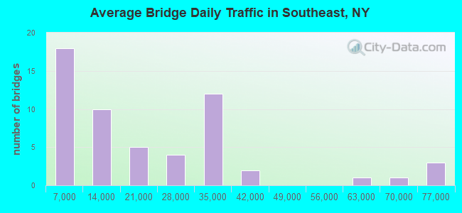
- 1,107,535Total average daily traffic
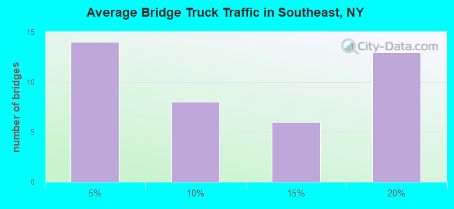
- 81,250Total average daily truck traffic
- National Bridge Inventory (NBI) Registered Bridges for Southeast
- No street view available for this location
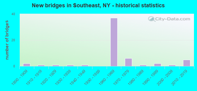
- New bridges - historical statistics
- 21900-1909
- 11910-1919
- 11920-1929
- 11930-1939
- 11940-1949
- 371960-1969
- 61970-1979
- 11980-1989
- 21990-1999
- 12000-2009
- 52010-2019
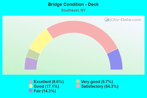
- Bridge Condition - Deck
- 8.6%Excellent
- 5.7%Very good
- 17.1%Good
- 54.3%Satisfactory
- 14.3%Fair
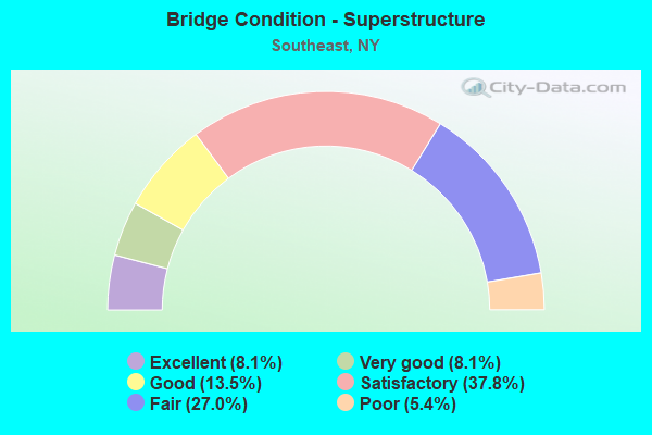
- Bridge Condition - Superstructure
- 8.1%Excellent
- 8.1%Very good
- 13.5%Good
- 37.8%Satisfactory
- 27.0%Fair
- 5.4%Poor
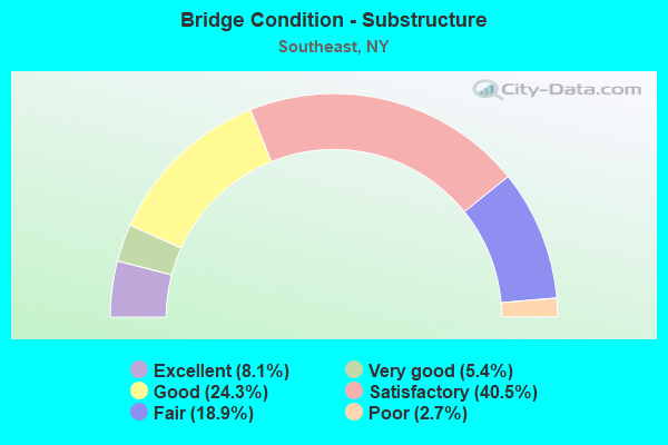
- Bridge Condition - Substructure
- 8.1%Excellent
- 5.4%Very good
- 24.3%Good
- 40.5%Satisfactory
- 18.9%Fair
- 2.7%Poor
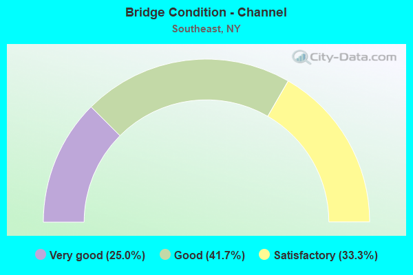
- Bridge Condition - Channel
- 25.0%Very good
- 41.7%Good
- 33.3%Satisfactory
Find on map >> Show street view
Structure Number: 1032592, Location: JCT RTS I684+I84 (Lat: 41.390378, Lng: -73.597958), Route carried "under" structure: Interstate 84, Year Built: 1967, Structure Length: 0. m, Average Daily Traffic: 17,000 (year 1979), Features Intersected: 84I84I84031097, RTE I84
Minimum Vertical Clearance: 5.46m (17.91ft), Kilometerpoint: 15.784, Lanes on structure: 3, Lanes under structure: 3, Material/Design: Steel, Design/Construction: Stringer/Multi-beam, Length of Maximum Span: 25.2m (82.7ft)
Find on map >> Show street view
Structure Number: 10326, Location: 0.3 MI E JCT RTS I84+I684 (Lat: 41.388389, Lng: -73.594069), Route carried "under" structure: Interstate 84, Year Built: 1967, Structure Length: 0. m, Average Daily Traffic: 73,250 (year 1999), Features Intersected: 84I 84I84031101 WB, RTE, Facility Carried by Structure: STARR RIDGE ROAD
Minimum Vertical Clearance: 7.29m (23.92ft), Kilometerpoint: 16.251, Lanes on structure: 2, Lanes under structure: 3, Material/Design: Steel, Design/Construction: Stringer/Multi-beam, Length of Maximum Span: 29.5m (96.8ft)
Find on map >> Show street view
Structure Number: 1032611, Location: 1.0 MI E JCT RTS I84+I684 (Lat: 41.383883, Lng: -73.582622), Route carried "under" structure: State highway 121, Year Built: 1967, Structure Length: 0. m, Average Daily Traffic: 3,000 (year 1972), Features Intersected: RTE 121, Facility Carried by Structure: RTE I84
Minimum Vertical Clearance: 4.85m (15.91ft), Kilometerpoint: 17.361, Lanes on structure: 2, Lanes under structure: 2, Material/Design: Steel, Design/Construction: Stringer/Multi-beam, Length of Maximum Span: 21.0m (68.9ft)
Find on map >> Show street view
Structure Number: 1032612, Location: 1.0 MI E JCT RTS I84+I684 (Lat: 41.383231, Lng: -73.582381), Route carried "under" structure: State highway 121, Year Built: 1967, Structure Length: 0. m, Average Daily Traffic: 3,000 (year 1972), Features Intersected: RTE 121, Facility Carried by Structure: RTE I84
Minimum Vertical Clearance: 4.80m (15.75ft), Kilometerpoint: 17.361, Lanes on structure: 2, Lanes under structure: 2, Material/Design: Steel, Design/Construction: Stringer/Multi-beam, Length of Maximum Span: 21.0m (68.9ft)
Find on map >> Show street view
Structure Number: 1032621, Location: 2.2 MI E JCT RTS I84+I684 (Lat: 41.385044, Lng: -73.559411), Route carried "under" structure: Other road , Year Built: 2014, Structure Length: 0. m, Features Intersected: DINGLE RIDGE RD, Facility Carried by Structure: RTE I84
Minimum Vertical Clearance: 4.67m (15.32ft), Kilometerpoint: 0.000, Lanes on structure: 2, Lanes under structure: 2, Material/Design: Prestressed concrete, Design/Construction: Tee Beam, Length of Maximum Span: 24.4m (80.1ft)
Find on map >> Show street view
Structure Number: 1032622, Location: 2.2 MI E JCT RTS I84+I684 (Lat: 41.384664, Lng: -73.559369), Route carried "under" structure: Other road , Year Built: 2014, Structure Length: 0. m, Features Intersected: DINGLE RIDGE RD, Facility Carried by Structure: RTE I84
Minimum Vertical Clearance: 4.67m (15.32ft), Kilometerpoint: 0.225, Lanes on structure: 3, Lanes under structure: 2, Material/Design: Prestressed concrete, Design/Construction: Tee Beam, Length of Maximum Span: 24.4m (80.1ft)
Find on map >> Show street view
Structure Number: 1033051, Location: 1.9 MI S JCT RTS I684+I84 (Lat: 41.372431, Lng: -73.614450), Route carried "under" structure: County highway , Year Built: 1967, Structure Length: 0. m, Average Daily Traffic: 874 (year 2019), Truck Traffic: 10%, Features Intersected: CO RD 55, Facility Carried by Structure: RTE I684
Minimum Vertical Clearance: 4.52m (14.83ft), Kilometerpoint: 1.899, Lanes on structure: 3, Lanes under structure: 2, Material/Design: Steel, Design/Construction: Stringer/Multi-beam, Length of Maximum Span: 16.4m (53.8ft)
Find on map >> Show street view
Structure Number: 1033052, Location: 1.9 MI S JCT I684 & I84 (Lat: 41.372278, Lng: -73.614142), Route carried "under" structure: County highway , Year Built: 1967, Structure Length: 0. m, Average Daily Traffic: 874 (year 2019), Truck Traffic: 10%, Features Intersected: COUNTY ROAD 55, Facility Carried by Structure: RTE I684
Minimum Vertical Clearance: 5.51m (18.08ft), Kilometerpoint: 1.448, Lanes on structure: 3, Lanes under structure: 2, Material/Design: Steel, Design/Construction: Stringer/Multi-beam, Length of Maximum Span: 17.0m (55.8ft)
Find on map >> Show street view
Structure Number: 10528, Location: I84 INT 19 (Lat: 41.424700, Lng: -73.626875), Route carried "under" structure: Interstate 84, Year Built: 1968, Structure Length: 0. m, Average Daily Traffic: 13,400 (year 1972), Features Intersected: 84I 84I84031068, RTE I84, Facility Carried by Structure: RTE 312
Minimum Vertical Clearance: 5.05m (16.57ft), Kilometerpoint: 11.247, Lanes on structure: 2, Lanes under structure: 3, Material/Design: Steel, Design/Construction: Stringer/Multi-beam, Length of Maximum Span: 40.8m (133.9ft)
Find on map >> Show street view
Structure Number: 1052831, Location: 1.1 MI E I84 INT 19 (Lat: 41.410800, Lng: -73.613575), Route carried "under" structure: County highway , Year Built: 1968, Structure Length: 0. m, Average Daily Traffic: 1,219 (year 2017), Truck Traffic: 4%, Features Intersected: COUNTY ROAD 58, Facility Carried by Structure: RTE I84
Minimum Vertical Clearance: 4.70m (15.42ft), Kilometerpoint: 1.271, Lanes on structure: 2, Lanes under structure: 2, Material/Design: Steel, Design/Construction: Stringer/Multi-beam, Length of Maximum Span: 29.2m (95.8ft)
Find on map >> Show street view
Structure Number: 1052832, Location: 1.1 MI E I84 INT 19 (Lat: 41.410625, Lng: -73.614000), Route carried "under" structure: County highway , Year Built: 1968, Structure Length: 0. m, Average Daily Traffic: 3,562 (year 2009), Truck Traffic: 4%, Features Intersected: COUNTY ROAD 58, Facility Carried by Structure: RTE I84
Minimum Vertical Clearance: 4.34m (14.24ft), Kilometerpoint: 0.000, Lanes on structure: 2, Lanes under structure: 2, Material/Design: Steel, Design/Construction: Stringer/Multi-beam, Length of Maximum Span: 29.2m (95.8ft)
Find on map >> Show street view
Structure Number: 1052841, Location: JCT RTS I84+6+22 (Lat: 41.398183, Lng: -73.600694), Route carried "under" structure: US 6, Year Built: 1970, Structure Length: 0. m, Average Daily Traffic: 11,064 (year 1999), Features Intersected: Argonne Ave, Riverside D, Facility Carried by Structure: RTE I84
Minimum Vertical Clearance: 22.99m (75.43ft), Kilometerpoint: 22.317, Lanes on structure: 2, Lanes under structure: 3, Material/Design: Steel, Design/Construction: Stringer/Multi-beam, Length of Maximum Span: 46.0m (150.9ft)
Find on map >> Show street view
Structure Number: 1052842, Location: JCT RTS I84+6+22 (Lat: 41.398086, Lng: -73.601069), Route carried "under" structure: US 6, Year Built: 1970, Structure Length: 0. m, Average Daily Traffic: 12,100 (year 1977), Features Intersected: Argonne Ave, Riverside D, Facility Carried by Structure: RTE I84
Minimum Vertical Clearance: 22.99m (75.43ft), Kilometerpoint: 58.889, Lanes on structure: 2, Lanes under structure: 3, Material/Design: Steel, Design/Construction: Stringer/Multi-beam, Length of Maximum Span: 45.4m (149.0ft)
Find on map >> Show street view
Structure Number: 1054241, Location: JCT I684 & US 6 (Lat: 41.394269, Lng: -73.596347), Route carried "under" structure: US 6, Year Built: 1967, Structure Length: 0. m, Average Daily Traffic: 11,064 (year 1999), Features Intersected: RTE 6, MNRR BE LINE
Minimum Vertical Clearance: 13.99m (45.90ft), Kilometerpoint: 22.767, Lanes on structure: 3, Lanes under structure: 4, Material/Design: Steel, Design/Construction: Stringer/Multi-beam, Length of Maximum Span: 46.9m (153.9ft)
Find on map >> Show street view
Structure Number: 1054242, Location: JCT I684 & US 6 (Lat: 41.393950, Lng: -73.596175), Route carried "under" structure: US 6, Year Built: 1967, Structure Length: 0. m, Average Daily Traffic: 11,064 (year 1999), Features Intersected: RTE 6, MNRR BE LINE
Minimum Vertical Clearance: 13.99m (45.90ft), Kilometerpoint: 22.767, Lanes on structure: 3, Lanes under structure: 4, Material/Design: Steel, Design/Construction: Stringer/Multi-beam, Length of Maximum Span: 37.1m (121.7ft)
Find on map >> Show street view
Structure Number: 105425, Location: 1.4 MI S JCT I84 & I684 (Lat: 41.375667, Lng: -73.606131), Route carried "under" structure: Interstate 684, Year Built: 1967, Structure Length: 0. m, Average Daily Traffic: 61,474 (year 2002), Features Intersected: 684I684I84021021 - NB, R, Facility Carried by Structure: TURK HILL ROAD
Minimum Vertical Clearance: 6.10m (20.01ft), Kilometerpoint: 43.604, Lanes on structure: 2, Lanes under structure: 3, Material/Design: Steel, Design/Construction: Stringer/Multi-beam, Length of Maximum Span: 24.9m (81.7ft)
Find on map >> Show street view
Structure Number: 105427, Location: .1 MI N JCT I684 & I84 (Lat: 41.392369, Lng: -73.597300), Route carried "under" structure: Interstate 684, Year Built: 1967, Structure Length: 0. m, Average Daily Traffic: 63,618 (year 2002), Features Intersected: 684I684I84021034, RTE I6, Facility Carried by Structure: RAMP G OF I84
Minimum Vertical Clearance: 4.88m (16.01ft), Kilometerpoint: 0.161, Lanes on structure: 1, Lanes under structure: 2, Material/Design: Steel, Design/Construction: Stringer/Multi-beam, Length of Maximum Span: 19.8m (65.0ft)
Find on map >> Show street view
Structure Number: 70035, Location: IN BREWSTER HEIGHTS (Lat: 41.412089, Lng: -73.638769), Route carried "under" structure: US 6, Year Built: 1960, Structure Length: 0. m, Average Daily Traffic: 8,470 (year 2000), Features Intersected: RTE 6, Facility Carried by Structure: PUTNAM TRAILWAY
Minimum Vertical Clearance: 4.41m (14.47ft), Kilometerpoint: 17.136, Lanes under structure: 2, Material/Design: Steel, Design/Construction: Girder and Floorbeam System, Length of Maximum Span: 31.6m (103.7ft)
Find on map >> Show street view
Structure Number: 700354, Location: .1 MI E JCT I684 & US 6 (Lat: 41.395167, Lng: -73.596728), Route carried "under" structure: US 6, Year Built: 1940, Structure Length: 0. m, Average Daily Traffic: 14,916 (year 1999), Features Intersected: RTE 6, Facility Carried by Structure: MNRR BE LINE
Minimum Vertical Clearance: 4.57m (14.99ft), Kilometerpoint: 22.124, Lanes under structure: 4, Material/Design: Steel, Design/Construction: Girder and Floorbeam System, Length of Maximum Span: 19.2m (63.0ft)