Bridge Statistics for Siler City, North Carolina (NC)
Condition, Traffic, Stress, Structural Evaluation, Project Costs
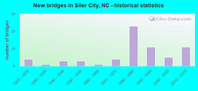
- New bridges - historical statistics
- 41920-1929
- 11930-1939
- 31940-1949
- 31950-1959
- 11960-1969
- 41970-1979
- 231980-1989
- 111990-1999
- 52000-2009
- 112010-2019
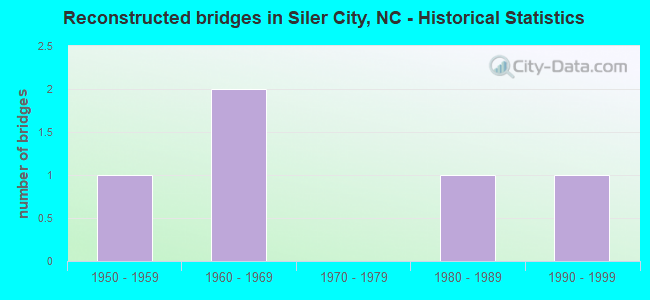
- Reconstructed bridges - Historical Statistics
- 11950-1959
- 21960-1969
- 01970-1979
- 11980-1989
- 11990-1999
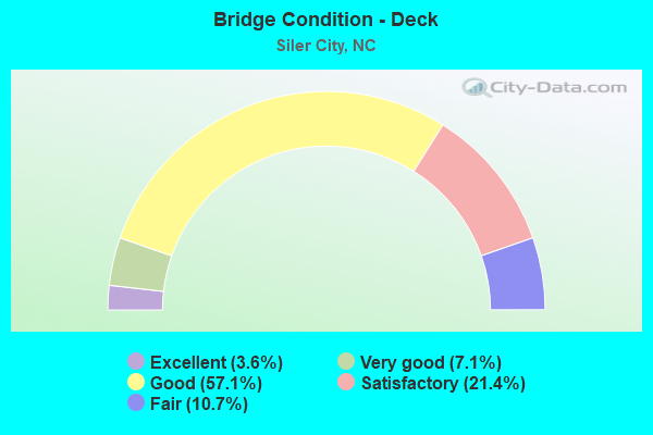
- Bridge Condition - Deck
- 3.6%Excellent
- 7.1%Very good
- 57.1%Good
- 21.4%Satisfactory
- 10.7%Fair
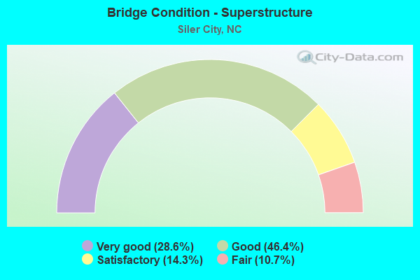
- Bridge Condition - Superstructure
- 28.6%Very good
- 46.4%Good
- 14.3%Satisfactory
- 10.7%Fair
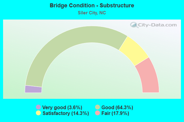
- Bridge Condition - Substructure
- 3.6%Very good
- 64.3%Good
- 14.3%Satisfactory
- 17.9%Fair
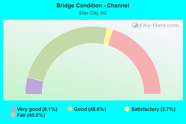
- Bridge Condition - Channel
- 8.1%Very good
- 48.6%Good
- 2.7%Satisfactory
- 40.5%Fair
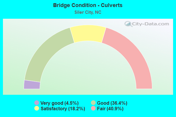
- Bridge Condition - Culverts
- 4.5%Very good
- 36.4%Good
- 18.2%Satisfactory
- 40.9%Fair
Find on map >> Show street view
Structure Number: 37052, Location: 1.1 MI. S. JCT. US64 (Lat: 35.717778, Lng: -79.423889), Route carried "on" structure: City street , Year Built: 2010, Status: Open, Structure Length: 0.64m (2.10ft), Average Daily Traffic: 100 (year 2010), Average Future Daily Traffic: 200 (year 2040), Design Load: HS 20, Features Intersected: CREEK, Facility Carried by Structure: PROGRESS BLVD.
Minimum Vertical Clearance: 30+ m (98+ ft), Kilometerpoint: 0.000, Lanes on structure: 2, Owner: City or Municipal Highway Agency, Approaching Roadway Width: 7.6m (24.9ft), Material/Design: Aluminum, Iron, Design/Construction: Culvert, Number Of Spans In Main Unit: 1, Length of Maximum Span: 6.0m (19.7ft)
Condition: Channel: Very good, Culverts: Good, Operating Rating: 89.8 metric tons, Method Used To Determine Operating Rating: Load and Resistance Factor (LRFR), Inventory Rating: 89.8 metric tons, Method Used To Determine Inventory Rating: Load and Resistance Factor (LRFR), Structural Evaluation: Better than present minimum criteria, Waterway Adequacy: Equal to present desirable criteria, Approach Roadway Alignment: Equal to present desirable criteria, Designated Inspection Frequency: Every 24 months, Inspection Date: April 2020
Find on map >> Show street view
Structure Number: 370521, Location: 1.3 MI. S. JCT. US64 (Lat: 35.716667, Lng: -79.424167), Route carried "on" structure: City street , Year Built: 2010, Status: Open, Structure Length: 0.82m (2.69ft), Average Daily Traffic: 100 (year 2013), Average Future Daily Traffic: 200 (year 2040), Features Intersected: VARNELL CREEK, Facility Carried by Structure: PROGRESS BLVD.
Minimum Vertical Clearance: 30+ m (98+ ft), Kilometerpoint: 0.000, Lanes on structure: 2, Owner: City or Municipal Highway Agency, Approaching Roadway Width: 7.9m (25.9ft), Skew: 3 degrees, Material/Design: Aluminum, Iron, Design/Construction: Culvert, Length of Maximum Span: 7.0m (23.0ft)
Condition: Channel: Very good, Culverts: Good, Operating Rating: 89.8 metric tons, Method Used To Determine Operating Rating: Load and Resistance Factor (LRFR), Inventory Rating: 89.8 metric tons, Method Used To Determine Inventory Rating: Load and Resistance Factor (LRFR), Structural Evaluation: Better than present minimum criteria, Waterway Adequacy: Equal to present desirable criteria, Approach Roadway Alignment: Equal to present desirable criteria, Designated Inspection Frequency: Every 24 months, Inspection Date: April 2020
Find on map >> Show street view
Structure Number: 370522, Location: 0.1 MI.E.JCT. PROG. BLVD. (Lat: 35.725278, Lng: -76.420556), Route carried "on" structure: City street , Year Built: 2010, Status: Open, Structure Length: 0.73m (2.40ft), Average Daily Traffic: 100 (year 2013), Average Future Daily Traffic: 200 (year 2040), Design Load: HS 20, Features Intersected: CREEK, Facility Carried by Structure: CAMPUS DRIVE
Minimum Vertical Clearance: 30+ m (98+ ft), Kilometerpoint: 0.000, Lanes on structure: 2, Owner: City or Municipal Highway Agency, Approaching Roadway Width: 7.6m (24.9ft), Skew: 2 degrees, Material/Design: Aluminum, Iron, Design/Construction: Culvert, Number Of Spans In Main Unit: 1, Length of Maximum Span: 7.0m (23.0ft)
Condition: Channel: Good, Culverts: Very good, Operating Rating: 89.8 metric tons, Method Used To Determine Operating Rating: Load and Resistance Factor (LRFR), Inventory Rating: 89.8 metric tons, Method Used To Determine Inventory Rating: Load and Resistance Factor (LRFR), Structural Evaluation: Equal to present desirable criteria, Waterway Adequacy: Equal to present desirable criteria, Approach Roadway Alignment: Equal to present desirable criteria, Designated Inspection Frequency: Every 24 months, Inspection Date: April 2020
Find on map >> Show street view
Structure Number: 370523, Location: 0.3 MI.E.JCT PROG. BLVD. (Lat: 35.720000, Lng: -79.418611), Route carried "on" structure: City street , Year Built: 2010, Status: Open, Structure Length: 0.79m (2.59ft), Average Daily Traffic: 100 (year 2013), Average Future Daily Traffic: 200 (year 2025), Design Load: HS 20, Features Intersected: CREEK, Facility Carried by Structure: TECHNOLOGY WAY
Minimum Vertical Clearance: 30+ m (98+ ft), Kilometerpoint: 0.000, Lanes on structure: 2, Owner: City or Municipal Highway Agency, Approaching Roadway Width: 7.3m (24.0ft), Skew: 2 degrees, Material/Design: Aluminum, Iron, Design/Construction: Culvert, Number Of Spans In Main Unit: 1, Length of Maximum Span: 7.0m (23.0ft)
Condition: Channel: Good, Culverts: Good, Operating Rating: 89.8 metric tons, Method Used To Determine Operating Rating: Load and Resistance Factor (LRFR), Inventory Rating: 89.8 metric tons, Method Used To Determine Inventory Rating: Load and Resistance Factor (LRFR), Structural Evaluation: Better than present minimum criteria, Waterway Adequacy: Equal to present desirable criteria, Approach Roadway Alignment: Equal to present desirable criteria, Designated Inspection Frequency: Every 24 months, Inspection Date: April 2020
Find on map >> Show street view
Structure Number: 370524, Location: 0.5 MI.E.JCT PROG. BLVD. (Lat: 35.721111, Lng: -79.414722), Route carried "on" structure: City street , Year Built: 2010, Status: Open, Structure Length: 0.70m (2.30ft), Average Daily Traffic: 100 (year 2013), Truck Traffic: 6%, Average Future Daily Traffic: 200 (year 2025), Design Load: HS 20, Features Intersected: CREEK, Facility Carried by Structure: TECHNOLOGY WAY
Minimum Vertical Clearance: 30+ m (98+ ft), Kilometerpoint: 0.000, Lanes on structure: 2, Owner: City or Municipal Highway Agency, Approaching Roadway Width: 7.6m (24.9ft), Material/Design: Aluminum, Iron, Design/Construction: Culvert, Number Of Spans In Main Unit: 1, Length of Maximum Span: 7.0m (23.0ft)
Condition: Channel: Very good, Culverts: Good, Operating Rating: 89.8 metric tons, Method Used To Determine Operating Rating: Load and Resistance Factor (LRFR), Inventory Rating: 89.8 metric tons, Method Used To Determine Inventory Rating: Load and Resistance Factor (LRFR), Structural Evaluation: Better than present minimum criteria, Waterway Adequacy: Equal to present desirable criteria, Approach Roadway Alignment: Equal to present desirable criteria, Designated Inspection Frequency: Every 24 months, Inspection Date: April 2020
Find on map >> Show street view
Structure Number: 1510582, Location: 0.2MI.W.OF US220 BUS (Lat: 35.700103, Lng: -79.466725), Route carried "on" structure: State highway 1145, Year Built: 2019, Status: Open, Structure Length: 1.06m (3.48ft), Average Daily Traffic: 290 (year 2016), Truck Traffic: 6%, Average Future Daily Traffic: 580 (year 2040), Design Load: HL 93, Features Intersected: BIG BRANCH
Minimum Vertical Clearance: 30+ m (98+ ft), Kilometerpoint: 0.000, Lanes on structure: 2, Owner: State Highway Agency, Approaching Roadway Width: 10.6m (34.8ft), Skew: 2 degrees, Material/Design: Concrete continuous, Design/Construction: Culvert, Number Of Spans In Main Unit: 3, Length of Maximum Span: 3.0m (9.8ft)
Condition: Channel: Fair, Culverts: Good, Operating Rating: 89.8 metric tons, Method Used To Determine Operating Rating: Load and Resistance Factor (LRFR), Inventory Rating: 89.8 metric tons, Method Used To Determine Inventory Rating: Load and Resistance Factor (LRFR), Structural Evaluation: Better than present minimum criteria, Waterway Adequacy: Better than present minimum criteria, Approach Roadway Alignment: Equal to present desirable criteria, Designated Inspection Frequency: Every 24 months, Inspection Date: May 2020
Find on map >> Show street view
Structure Number: 370023, Location: 0.6 MI. N. JCT. SR1108 (Lat: 35.733525, Lng: -79.469506), Route carried "under" structure: US 64, Year Built: 2001, Structure Length: 0. m, Average Daily Traffic: 12,000 (year 2015), Truck Traffic: 12%, Features Intersected: SR1108
Minimum Vertical Clearance: 6.19m (20.31ft), Kilometerpoint: 0.000, Lanes on structure: 2, Lanes under structure: 5, Material/Design: Steel, Design/Construction: Stringer/Multi-beam, Length of Maximum Span: 47.8m (156.8ft)
Find on map >> Show street view
Structure Number: 370027, Location: 70 FT. W. JCT. SR1317 (Lat: 35.733439, Lng: -79.466964), Route carried "under" structure: State highway 1006, Year Built: 1985, Structure Length: 0. m, Average Daily Traffic: 3,100 (year 2018), Truck Traffic: 6%, Features Intersected: US64
Minimum Vertical Clearance: 4.90m (16.08ft), Kilometerpoint: 0.000, Lanes on structure: 5, Lanes under structure: 2, Material/Design: Steel, Design/Construction: Stringer/Multi-beam, Length of Maximum Span: 25.2m (82.7ft)
Find on map >> Show street view
Structure Number: 370442, Location: 1.3 MI. S. JCT. US64 (Lat: 35.716039, Lng: -79.429161), Route carried "under" structure: State highway 2110, Year Built: 1982, Structure Length: 0. m, Average Daily Traffic: 2,200 (year 2018), Truck Traffic: 6%, Features Intersected: US421N
Minimum Vertical Clearance: 6.12m (20.08ft), Kilometerpoint: 0.000, Lanes on structure: 2, Lanes under structure: 2, Material/Design: Steel, Design/Construction: Stringer/Multi-beam, Length of Maximum Span: 21.9m (71.9ft)
Find on map >> Show street view
Structure Number: 370443, Location: 1.3 MI. S. JCT. US64 (Lat: 35.716028, Lng: -79.429486), Route carried "under" structure: State highway 2110, Year Built: 1982, Structure Length: 0. m, Average Daily Traffic: 1,800 (year 2012), Truck Traffic: 6%, Features Intersected: US421S
Minimum Vertical Clearance: 5.33m (17.49ft), Kilometerpoint: 0.000, Lanes on structure: 2, Lanes under structure: 2, Material/Design: Steel, Design/Construction: Stringer/Multi-beam, Length of Maximum Span: 21.9m (71.9ft)
Find on map >> Show street view
Structure Number: 370445, Location: 0.3 MI. S. JCT. SR1363 (Lat: 35.748578, Lng: -79.446372), Route carried "under" structure: US 421, Year Built: 1984, Structure Length: 0. m, Average Daily Traffic: 8,000 (year 2018), Truck Traffic: 12%, Features Intersected: SR1004
Minimum Vertical Clearance: 5.08m (16.67ft), Kilometerpoint: 52.548, Lanes on structure: 2, Lanes under structure: 2, Material/Design: Steel, Design/Construction: Stringer/Multi-beam, Length of Maximum Span: 35.3m (115.8ft)
Find on map >> Show street view
Structure Number: 370445, Location: 0.3 MI. S. JCT. SR1363 (Lat: 35.748578, Lng: -79.446372), Route carried "under" structure: US 421, Year Built: 1984, Structure Length: 0. m, Average Daily Traffic: 8,000 (year 2018), Truck Traffic: 12%, Features Intersected: SR1004
Minimum Vertical Clearance: 5.23m (17.16ft), Kilometerpoint: 52.548, Lanes on structure: 2, Lanes under structure: 2, Material/Design: Steel, Design/Construction: Stringer/Multi-beam, Length of Maximum Span: 35.3m (115.8ft)
Find on map >> Show street view
Structure Number: 370447, Location: 0.1 MI. E. JCT.SR1373 (Lat: 35.734264, Lng: -79.431750), Route carried "under" structure: US 421, Year Built: 1984, Structure Length: 0. m, Average Daily Traffic: 8,000 (year 2018), Truck Traffic: 12%, Features Intersected: US64
Minimum Vertical Clearance: 5.08m (16.67ft), Kilometerpoint: 0.000, Lanes on structure: 4, Lanes under structure: 2, Material/Design: Steel, Design/Construction: Stringer/Multi-beam, Length of Maximum Span: 36.2m (118.8ft)
Find on map >> Show street view
Structure Number: 370447, Location: 0.1 MI. E. JCT.SR1373 (Lat: 35.734264, Lng: -79.431750), Route carried "under" structure: US 421, Year Built: 1984, Structure Length: 0. m, Average Daily Traffic: 8,000 (year 2018), Truck Traffic: 12%, Features Intersected: US64
Minimum Vertical Clearance: 5.30m (17.39ft), Kilometerpoint: 0.000, Lanes on structure: 4, Lanes under structure: 2, Material/Design: Steel, Design/Construction: Stringer/Multi-beam, Length of Maximum Span: 36.2m (118.8ft)
Find on map >> Show street view
Structure Number: 370449, Location: 0.5 MI. N. JCT. SR1380 (Lat: 35.764206, Lng: -79.474103), Route carried "under" structure: US 421, Year Built: 1987, Structure Length: 0. m, Average Daily Traffic: 8,500 (year 2018), Truck Traffic: 12%, Features Intersected: SR1362
Minimum Vertical Clearance: 5.30m (17.39ft), Kilometerpoint: 53.066, Lanes on structure: 2, Lanes under structure: 2, Material/Design: Steel, Design/Construction: Stringer/Multi-beam, Length of Maximum Span: 42.6m (139.8ft)
Find on map >> Show street view
Structure Number: 370449, Location: 0.5 MI. N. JCT. SR1380 (Lat: 35.764206, Lng: -79.474103), Route carried "under" structure: US 421, Year Built: 1987, Structure Length: 0. m, Average Daily Traffic: 8,500 (year 2018), Truck Traffic: 12%, Features Intersected: SR1362
Minimum Vertical Clearance: 5.12m (16.80ft), Kilometerpoint: 53.066, Lanes on structure: 2, Lanes under structure: 2, Material/Design: Steel, Design/Construction: Stringer/Multi-beam, Length of Maximum Span: 42.6m (139.8ft)
Find on map >> Show street view
Structure Number: 37045, Location: 0.1 MI. W. JCT. SR1312 (Lat: 35.777656, Lng: -79.503025), Route carried "under" structure: US 421, Year Built: 1987, Structure Length: 0. m, Average Daily Traffic: 8,500 (year 2018), Truck Traffic: 14%, Features Intersected: SR1310
Minimum Vertical Clearance: 5.56m (18.24ft), Kilometerpoint: 53.645, Lanes on structure: 2, Lanes under structure: 2, Material/Design: Prestressed concrete, Design/Construction: Stringer/Multi-beam, Length of Maximum Span: 20.4m (66.9ft)
Find on map >> Show street view
Structure Number: 370451, Location: 0.1 MI.S.JCT.SR1381 (Lat: 35.752692, Lng: -79.453658), Route carried "under" structure: US 421, Year Built: 1987, Structure Length: 0. m, Average Daily Traffic: 8,000 (year 2018), Truck Traffic: 12%, Features Intersected: SR1316
Minimum Vertical Clearance: 5.08m (16.67ft), Kilometerpoint: 52.639, Lanes on structure: 2, Lanes under structure: 2, Material/Design: Steel, Design/Construction: Stringer/Multi-beam, Length of Maximum Span: 31.3m (102.7ft)
Find on map >> Show street view
Structure Number: 370451, Location: 0.1 MI.S.JCT.SR1381 (Lat: 35.752692, Lng: -79.453658), Route carried "under" structure: US 421, Year Built: 1987, Structure Length: 0. m, Average Daily Traffic: 8,000 (year 2018), Truck Traffic: 12%, Features Intersected: SR1316
Minimum Vertical Clearance: 5.74m (18.83ft), Kilometerpoint: 52.639, Lanes on structure: 2, Lanes under structure: 2, Material/Design: Steel, Design/Construction: Stringer/Multi-beam, Length of Maximum Span: 31.3m (102.7ft)
Find on map >> Show street view
Structure Number: 370467, Location: 1.5 MI. S. JCT. SR2110 (Lat: 35.694211, Lng: -79.427483), Route carried "under" structure: State highway 2113, Year Built: 1991, Structure Length: 0. m, Average Daily Traffic: 3,300 (year 2018), Truck Traffic: 8%, Features Intersected: US421 NBL
Minimum Vertical Clearance: 5.02m (16.47ft), Kilometerpoint: 0.000, Lanes on structure: 2, Lanes under structure: 2, Material/Design: Steel, Design/Construction: Stringer/Multi-beam, Length of Maximum Span: 36.5m (119.8ft)
Find on map >> Show street view
Structure Number: 370472, Location: 0.7 MI. E. JCT. SR2110 (Lat: 35.694233, Lng: -79.427831), Route carried "under" structure: State highway 2113, Year Built: 1991, Structure Length: 0. m, Average Daily Traffic: 3,300 (year 2018), Truck Traffic: 8%, Features Intersected: US421S
Minimum Vertical Clearance: 5.05m (16.57ft), Kilometerpoint: 0.000, Lanes on structure: 2, Lanes under structure: 2, Material/Design: Steel, Design/Construction: Stringer/Multi-beam, Length of Maximum Span: 36.5m (119.8ft)
Find on map >> Show street view
Structure Number: 370475, Location: 0.8 MI.N.JCT.US421 BUS. (Lat: 35.778403, Lng: -79.502706), Route carried "under" structure: US 421, Year Built: 1996, Structure Length: 0. m, Average Daily Traffic: 8,500 (year 2018), Truck Traffic: 14%, Features Intersected: SR1310
Minimum Vertical Clearance: 5.10m (16.73ft), Kilometerpoint: 53.675, Lanes on structure: 2, Lanes under structure: 2, Material/Design: Prestressed concrete continuous, Design/Construction: Stringer/Multi-beam, Length of Maximum Span: 16.7m (54.8ft)