Bridge Statistics for Sherman, Texas (TX)
Condition, Traffic, Stress, Structural Evaluation, Project Costs
- National Bridge Inventory (NBI) Statistics
- 174Number of bridges
- 1,969ft / 600mTotal length
- $1,135,000Total costs
- 1,569,675Total average daily traffic
- 143,682Total average daily truck traffic
- National Bridge Inventory (NBI) Registered Bridges for Sherman
- No street view available for this location
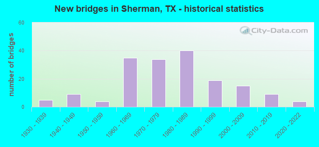
- New bridges - historical statistics
- 51930-1939
- 91940-1949
- 41950-1959
- 351960-1969
- 341970-1979
- 401980-1989
- 191990-1999
- 152000-2009
- 92010-2019
- 42020-2022

- Reconstructed bridges - Historical Statistics
- 31950-1959
- 01960-1969
- 21970-1979
- 11980-1989
- 31990-1999
- 12000-2009
- 12010-2019
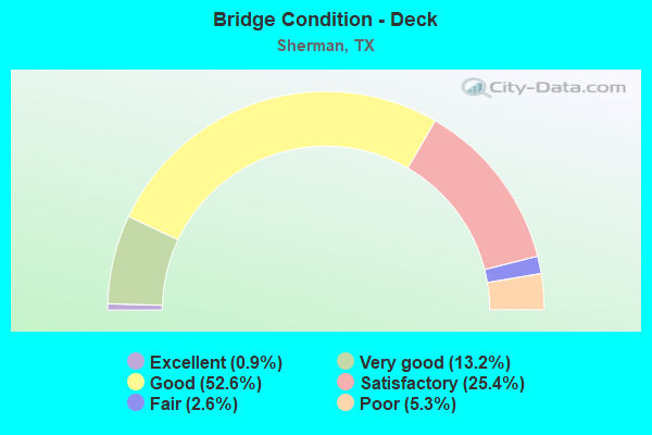
- Bridge Condition - Deck
- 0.9%Excellent
- 13.2%Very good
- 52.6%Good
- 25.4%Satisfactory
- 2.6%Fair
- 5.3%Poor
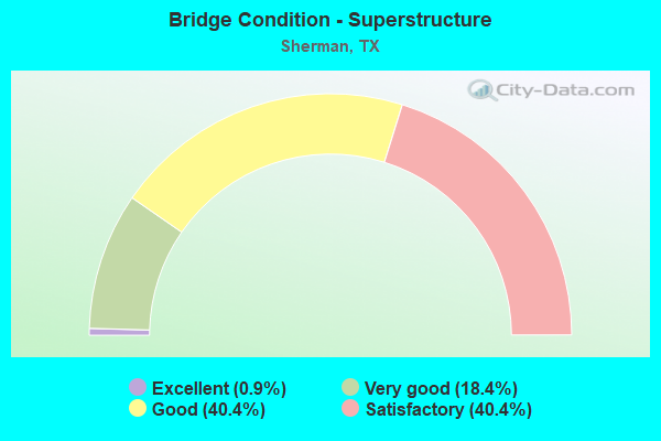
- Bridge Condition - Superstructure
- 0.9%Excellent
- 18.4%Very good
- 40.4%Good
- 40.4%Satisfactory
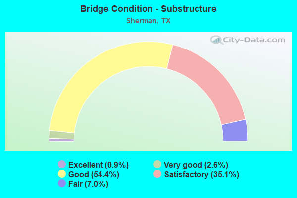
- Bridge Condition - Substructure
- 0.9%Excellent
- 2.6%Very good
- 54.4%Good
- 35.1%Satisfactory
- 7.0%Fair
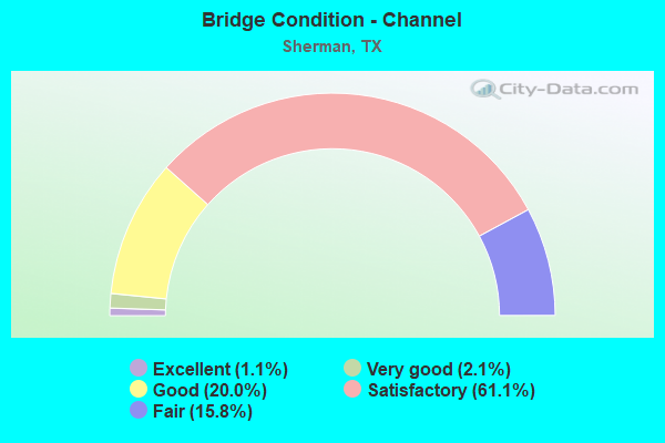
- Bridge Condition - Channel
- 1.1%Excellent
- 2.1%Very good
- 20.0%Good
- 61.1%Satisfactory
- 15.8%Fair
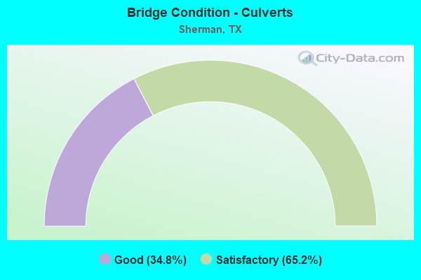
- Bridge Condition - Culverts
- 34.8%Good
- 65.2%Satisfactory
Find on map >> Show street view
Structure Number: 10920004503153, Location: 0.1 MI W OF US 75 (Lat: 33.634022, Lng: -96.616881), Route carried "on" structure: State highway 56, Year Built: 1945, Status: Open, Structure Length: 1.89m (6.20ft), Average Daily Traffic: 9,130 (year 2013), Truck Traffic: 6%, Average Future Daily Traffic: 12,790 (year 2033), Features Intersected: POST OAK CREEK
Minimum Vertical Clearance: 30+ m (98+ ft), Kilometerpoint: 31.368, Lanes on structure: 2, Owner: City or Municipal Highway Agency, Approaching Roadway Width: 9.1m (29.9ft), Material/Design: Steel, Design/Construction: Stringer/Multi-beam, Number Of Spans In Main Unit: 1, Length of Maximum Span: 18.9m (62.0ft), Curb or Sidewalk Widths: Left: 1.2m (3.9ft), Right: 1.2m (3.9ft), Curb-To-Curb Width: 10.9m (35.8ft), Out-to-Out Width: 13.4m (44.0ft)
Condition: Deck: Satisfactory, Superstructure: Satisfactory, Substructure: Satisfactory, Channel: Satisfactory, Operating Rating: 46.3 metric tons, Method Used To Determine Operating Rating: Load Factor (LF), Inventory Rating: 27.2 metric tons, Method Used To Determine Inventory Rating: Load Factor (LF), Structural Evaluation: Equal to present minimum criteria, Deck Geometry: Somewhat better than minimum adequacy, Waterway Adequacy: Equal to present minimum criteria, Approach Roadway Alignment: Equal to present desirable criteria, Designated Inspection Frequency: Every 24 months, Inspection Date: April 2021, Deck Structure Type: Concrete Cast-file-Place, Wearing Surface/Protective System: Wearing Surface: Bituminous
Find on map >> Show street view
Structure Number: 10920004503185, Location: 0.9 MI W OF US 75 (Lat: 33.631247, Lng: -96.629822), Route carried "on" structure: State highway 56, Year Built: 2001, Status: Open, Structure Length: 5.40m (17.72ft), Average Daily Traffic: 11,550 (year 2013), Truck Traffic: 6%, Average Future Daily Traffic: 16,180 (year 2033), Design Load: HS 20, Features Intersected: SAND CREEK
Minimum Vertical Clearance: 30+ m (98+ ft), Kilometerpoint: 29.985, Lanes on structure: 2, Owner: State Highway Agency, Approaching Roadway Width: 11.3m (37.1ft), Material/Design: Prestressed concrete, Design/Construction: Stringer/Multi-beam, Number Of Spans In Main Unit: 2, Length of Maximum Span: 29.9m (98.1ft), Curb-To-Curb Width: 11.3m (37.1ft), Out-to-Out Width: 12.0m (39.4ft)
Condition: Deck: Very good, Superstructure: Very good, Substructure: Good, Channel: Very good, Operating Rating: 68.0 metric tons, Method Used To Determine Operating Rating: Load Factor (LF), Inventory Rating: 40.8 metric tons, Method Used To Determine Inventory Rating: Load Factor (LF), Structural Evaluation: Better than present minimum criteria, Deck Geometry: Equal to present minimum criteria, Waterway Adequacy: Equal to present minimum criteria, Approach Roadway Alignment: Equal to present desirable criteria, Designated Inspection Frequency: Every 24 months, Inspection Date: April 2021, Deck Structure Type: Concrete Precast Panels
Find on map >> Show street view
Structure Number: 10920004503186, Location: 0.9 MI W OF US 75 (Lat: 33.631864, Lng: -96.629775), Route carried "on" structure: State highway 56, Year Built: 2001, Status: Open, Structure Length: 5.40m (17.72ft), Average Daily Traffic: 11,550 (year 2013), Truck Traffic: 6%, Average Future Daily Traffic: 16,180 (year 2033), Design Load: HS 20, Features Intersected: SAND CREEK
Minimum Vertical Clearance: 30+ m (98+ ft), Kilometerpoint: 29.987, Lanes on structure: 2, Owner: State Highway Agency, Approaching Roadway Width: 11.3m (37.1ft), Material/Design: Prestressed concrete, Design/Construction: Stringer/Multi-beam, Number Of Spans In Main Unit: 2, Length of Maximum Span: 29.9m (98.1ft), Curb-To-Curb Width: 11.3m (37.1ft), Out-to-Out Width: 12.0m (39.4ft)
Condition: Deck: Good, Superstructure: Very good, Substructure: Good, Channel: Satisfactory, Operating Rating: 68.0 metric tons, Method Used To Determine Operating Rating: Load Factor (LF), Inventory Rating: 40.8 metric tons, Method Used To Determine Inventory Rating: Load Factor (LF), Structural Evaluation: Better than present minimum criteria, Deck Geometry: Equal to present minimum criteria, Waterway Adequacy: Equal to present minimum criteria, Approach Roadway Alignment: Equal to present desirable criteria, Designated Inspection Frequency: Every 24 months, Inspection Date: April 2021, Total Project Cost: $5,000, Deck Structure Type: Concrete Precast Panels
Find on map >> Show street view
Structure Number: 10920004503193, Location: 0.1 MI W OF US 75 (Lat: 33.635092, Lng: -96.616886), Route carried "on" structure: State highway 56, Year Built: 2001, Status: Open, Structure Length: 2.04m (6.69ft), Average Daily Traffic: 9,130 (year 2013), Truck Traffic: 6%, Average Future Daily Traffic: 12,790 (year 2033), Design Load: HS 20, Features Intersected: POST OAK CREEK
Minimum Vertical Clearance: 30+ m (98+ ft), Kilometerpoint: 31.371, Lanes on structure: 2, Owner: State Highway Agency, Approaching Roadway Width: 9.1m (29.9ft), Material/Design: Prestressed concrete, Design/Construction: Stringer/Multi-beam, Number Of Spans In Main Unit: 1, Length of Maximum Span: 20.4m (66.9ft), Curb or Sidewalk Widths: Left: 2.1m (6.9ft), Right: 2.1m (6.9ft), Curb-To-Curb Width: 9.1m (29.9ft), Out-to-Out Width: 14.0m (45.9ft)
Condition: Deck: Very good, Superstructure: Very good, Substructure: Satisfactory, Channel: Satisfactory, Operating Rating: 68.0 metric tons, Method Used To Determine Operating Rating: Load Factor (LF), Inventory Rating: 40.8 metric tons, Method Used To Determine Inventory Rating: Load Factor (LF), Structural Evaluation: Equal to present minimum criteria, Deck Geometry: Meets minimum limits, Waterway Adequacy: Equal to present minimum criteria, Approach Roadway Alignment: Equal to present desirable criteria, Designated Inspection Frequency: Every 24 months, Inspection Date: April 2021, Deck Structure Type: Concrete Precast Panels
Find on map >> Show street view
Structure Number: 10920004503247, Location: 1.8 MI. W OF US 75 (Lat: 33.627869, Lng: -96.645103), Route carried "on" structure: State highway 1417, Year Built: 2009, Status: Open, Structure Length: 3.81m (12.50ft), Average Daily Traffic: 10,250 (year 2013), Truck Traffic: 15%, Average Future Daily Traffic: 14,350 (year 2033), Design Load: HL 93, Features Intersected: SH 56
Minimum Vertical Clearance: 30+ m (98+ ft), Kilometerpoint: 9.210, Lanes on structure: 2, Lanes under structure: 4, Owner: State Highway Agency, Approaching Roadway Width: 14.6m (47.9ft), Skew: 1 degrees, Material/Design: Prestressed concrete, Design/Construction: Stringer/Multi-beam, Number Of Spans In Main Unit: 1, Length of Maximum Span: 38.1m (125.0ft), Curb-To-Curb Width: 14.4m (47.2ft), Out-to-Out Width: 15.2m (49.9ft)
Condition: Deck: Good, Superstructure: Good, Substructure: Good, Operating Rating: 54.4 metric tons, Method Used To Determine Operating Rating: Load Factor (LF), Inventory Rating: 32.7 metric tons, Method Used To Determine Inventory Rating: Load Factor (LF), Structural Evaluation: Better than present minimum criteria, Deck Geometry: Superior to present desirable criteria, Underclear: Better than present minimum criteria, Approach Roadway Alignment: Equal to present desirable criteria, Designated Inspection Frequency: Every 24 months, Inspection Date: April 2021, Deck Structure Type: Concrete Cast-file-Place, Wearing Surface/Protective System: Wearing Surface: Integral Concrete
Find on map >> Show street view
Structure Number: 10920004504018, Location: 0.05 MI E OF FM 1417 (Lat: 33.640236, Lng: -96.565175), Route carried "on" structure: State highway 56, Year Built: 1930, Year Reconstructed: 1955, Status: Open, Structure Length: 0.67m (2.20ft), Average Daily Traffic: 3,391 (year 2018), Truck Traffic: 4%, Average Future Daily Traffic: 4,250 (year 2033), Features Intersected: CALF CREEK
Minimum Vertical Clearance: 30+ m (98+ ft), Kilometerpoint: 36.239, Lanes on structure: 2, Owner: State Highway Agency, Approaching Roadway Width: 13.4m (44.0ft), Material/Design: Concrete, Design/Construction: Culvert, Number Of Spans In Main Unit: 2, Length of Maximum Span: 3.0m (9.8ft), Curb-To-Curb Width: 13.8m (45.3ft), Out-to-Out Width: 22.7m (74.5ft)
Condition: Channel: Satisfactory, Culverts: Satisfactory, Operating Rating: 32.7 metric tons, Method Used To Determine Operating Rating: Field evaluation and documented engineering judgment, Inventory Rating: 24.5 metric tons, Method Used To Determine Inventory Rating: Field evaluation and documented engineering judgment, Structural Evaluation: Equal to present minimum criteria, Deck Geometry: Superior to present desirable criteria, Waterway Adequacy: Equal to present minimum criteria, Approach Roadway Alignment: Equal to present desirable criteria, Designated Inspection Frequency: Every 24 months, Inspection Date: March 2021, Deck Structure Type: Concrete Cast-file-Place, Wearing Surface/Protective System: Wearing Surface: Bituminous
Find on map >> Show street view
Structure Number: 10920004504019, Location: 1.65 MI E OF FM 1417 (Lat: 33.635286, Lng: -96.536875), Route carried "on" structure: State highway 56, Year Built: 1930, Year Reconstructed: 1955, Status: Open, Structure Length: 0.70m (2.30ft), Average Daily Traffic: 3,391 (year 2018), Truck Traffic: 6%, Average Future Daily Traffic: 6,690 (year 2033), Features Intersected: BLUE CREEK
Minimum Vertical Clearance: 30+ m (98+ ft), Kilometerpoint: 35.315, Lanes on structure: 2, Owner: State Highway Agency, Approaching Roadway Width: 13.4m (44.0ft), Skew: 1 degrees, Material/Design: Concrete, Design/Construction: Culvert, Number Of Spans In Main Unit: 2, Length of Maximum Span: 3.0m (9.8ft), Curb-To-Curb Width: 13.8m (45.3ft), Out-to-Out Width: 26.2m (86.0ft)
Condition: Channel: Satisfactory, Culverts: Satisfactory, Operating Rating: 32.7 metric tons, Method Used To Determine Operating Rating: Field evaluation and documented engineering judgment, Inventory Rating: 24.5 metric tons, Method Used To Determine Inventory Rating: Field evaluation and documented engineering judgment, Structural Evaluation: Equal to present minimum criteria, Deck Geometry: Superior to present desirable criteria, Waterway Adequacy: Equal to present minimum criteria, Approach Roadway Alignment: Equal to present desirable criteria, Designated Inspection Frequency: Every 24 months, Inspection Date: March 2021, Deck Structure Type: Concrete Cast-file-Place, Wearing Surface/Protective System: Wearing Surface: Bituminous
Find on map >> Show street view
Structure Number: 1092000450402, Location: 2.60 MI E OF FM 1417 (Lat: 33.634058, Lng: -96.519106), Route carried "on" structure: State highway 56, Year Built: 1930, Year Reconstructed: 1955, Status: Open, Structure Length: 0.98m (3.22ft), Average Daily Traffic: 2,311 (year 2018), Truck Traffic: 4%, Average Future Daily Traffic: 4,250 (year 2033), Features Intersected: BLUE CREEK
Minimum Vertical Clearance: 30+ m (98+ ft), Kilometerpoint: 36.928, Lanes on structure: 2, Owner: State Highway Agency, Approaching Roadway Width: 13.4m (44.0ft), Material/Design: Concrete, Design/Construction: Culvert, Number Of Spans In Main Unit: 3, Length of Maximum Span: 3.0m (9.8ft), Curb-To-Curb Width: 13.4m (44.0ft), Out-to-Out Width: 19.0m (62.3ft)
Condition: Channel: Satisfactory, Culverts: Satisfactory, Operating Rating: 32.7 metric tons, Method Used To Determine Operating Rating: Field evaluation and documented engineering judgment, Inventory Rating: 24.5 metric tons, Method Used To Determine Inventory Rating: Field evaluation and documented engineering judgment, Structural Evaluation: Equal to present minimum criteria, Deck Geometry: Better than present minimum criteria, Waterway Adequacy: Equal to present minimum criteria, Approach Roadway Alignment: Equal to present desirable criteria, Designated Inspection Frequency: Every 24 months, Inspection Date: March 2021, Deck Structure Type: Concrete Cast-file-Place, Wearing Surface/Protective System: Wearing Surface: Bituminous
Find on map >> Show street view
Structure Number: 10920004518134, Location: 4.1 MI W OF FM 1417 (Lat: 33.671033, Lng: -96.714936), Route carried "on" structure: US 82, Year Built: 1971, Status: Open, Structure Length: 2.44m (8.01ft), Average Daily Traffic: 9,120 (year 2020), Truck Traffic: 2%, Average Future Daily Traffic: 11,960 (year 2033), Design Load: HS 20, Features Intersected: HARRIS CREEK
Minimum Vertical Clearance: 30+ m (98+ ft), Kilometerpoint: 21.773, Lanes on structure: 2, Owner: State Highway Agency, Approaching Roadway Width: 12.2m (40.0ft), Material/Design: Concrete, Design/Construction: Stringer/Multi-beam, Number Of Spans In Main Unit: 2, Length of Maximum Span: 12.2m (40.0ft), Curb-To-Curb Width: 12.8m (42.0ft), Out-to-Out Width: 13.5m (44.3ft)
Condition: Deck: Satisfactory, Superstructure: Satisfactory, Substructure: Good, Channel: Satisfactory, Operating Rating: 68.0 metric tons, Method Used To Determine Operating Rating: Load Factor (LF), Inventory Rating: 40.8 metric tons, Method Used To Determine Inventory Rating: Load Factor (LF), Structural Evaluation: Equal to present minimum criteria, Deck Geometry: Equal to present desirable criteria, Waterway Adequacy: Equal to present minimum criteria, Approach Roadway Alignment: Equal to present desirable criteria, Designated Inspection Frequency: Every 24 months, Inspection Date: April 2021, Deck Structure Type: Concrete Cast-file-Place
Find on map >> Show street view
Structure Number: 10920004518135, Location: 4.1 MI W OF FM 1417 (Lat: 33.670856, Lng: -96.714936), Route carried "on" structure: US 82, Year Built: 1971, Status: Open, Structure Length: 2.44m (8.01ft), Average Daily Traffic: 9,284 (year 2020), Truck Traffic: 2%, Average Future Daily Traffic: 11,960 (year 2033), Design Load: HS 20, Features Intersected: HARRIS CREEK
Minimum Vertical Clearance: 30+ m (98+ ft), Kilometerpoint: 21.773, Lanes on structure: 2, Owner: State Highway Agency, Approaching Roadway Width: 12.2m (40.0ft), Material/Design: Concrete, Design/Construction: Stringer/Multi-beam, Number Of Spans In Main Unit: 2, Length of Maximum Span: 12.2m (40.0ft), Curb-To-Curb Width: 12.8m (42.0ft), Out-to-Out Width: 13.5m (44.3ft)
Condition: Deck: Satisfactory, Superstructure: Good, Substructure: Satisfactory, Channel: Satisfactory, Operating Rating: 68.0 metric tons, Method Used To Determine Operating Rating: Load Factor (LF), Inventory Rating: 40.8 metric tons, Method Used To Determine Inventory Rating: Load Factor (LF), Structural Evaluation: Equal to present minimum criteria, Deck Geometry: Equal to present desirable criteria, Waterway Adequacy: Equal to present minimum criteria, Approach Roadway Alignment: Equal to present desirable criteria, Designated Inspection Frequency: Every 24 months, Inspection Date: April 2021, Deck Structure Type: Concrete Cast-file-Place
Find on map >> Show street view
Structure Number: 10920004518136, Location: 3.3 MI W OF FM 1417 (Lat: 33.671092, Lng: -96.699886), Route carried "on" structure: US 82, Year Built: 1971, Year Reconstructed: 2009, Status: Open, Structure Length: 0.76m (2.49ft), Average Daily Traffic: 24,327 (year 2019), Truck Traffic: 2%, Average Future Daily Traffic: 24,650 (year 2033), Design Load: HS 20, Features Intersected: BRANCH HARRIS CRK
Minimum Vertical Clearance: 30+ m (98+ ft), Kilometerpoint: 23.147, Lanes on structure: 5, Owner: State Highway Agency, Approaching Roadway Width: 32.6m (107.0ft), Skew: 24 degrees, Material/Design: Concrete, Design/Construction: Culvert, Number Of Spans In Main Unit: 3, Length of Maximum Span: 1.5m (4.9ft)
Condition: Channel: Satisfactory, Culverts: Good, Operating Rating: 39.9 metric tons, Method Used To Determine Operating Rating: Load Factor (LF), Inventory Rating: 23.6 metric tons, Method Used To Determine Inventory Rating: Load Factor (LF), Structural Evaluation: Somewhat better than minimum adequacy, Waterway Adequacy: Superior to present desirable criteria, Approach Roadway Alignment: Equal to present desirable criteria, Designated Inspection Frequency: Every 24 months, Inspection Date: April 2021
Find on map >> Show street view
Structure Number: 10920004518137, Location: 0.5 MI W OF FM 1417 (Lat: 33.671208, Lng: -96.651714), Route carried "on" structure: US 82, Year Built: 1971, Status: Open, Structure Length: 4.02m (13.19ft), Average Daily Traffic: 12,012 (year 2019), Truck Traffic: 2%, Average Future Daily Traffic: 12,320 (year 2033), Design Load: HS 20, Features Intersected: POST OAK CREEK
Minimum Vertical Clearance: 30+ m (98+ ft), Kilometerpoint: 27.735, Lanes on structure: 2, Owner: State Highway Agency, Approaching Roadway Width: 12.8m (42.0ft), Skew: 4 degrees, Material/Design: Concrete, Design/Construction: Stringer/Multi-beam, Number Of Spans In Main Unit: 3, Length of Maximum Span: 12.2m (40.0ft), Curb-To-Curb Width: 12.8m (42.0ft), Out-to-Out Width: 13.5m (44.3ft)
Condition: Deck: Satisfactory, Superstructure: Satisfactory, Substructure: Satisfactory, Channel: Good, Operating Rating: 68.0 metric tons, Method Used To Determine Operating Rating: Load Factor (LF), Inventory Rating: 40.8 metric tons, Method Used To Determine Inventory Rating: Load Factor (LF), Structural Evaluation: Equal to present minimum criteria, Deck Geometry: Equal to present desirable criteria, Waterway Adequacy: Equal to present minimum criteria, Approach Roadway Alignment: Equal to present desirable criteria, Designated Inspection Frequency: Every 24 months, Inspection Date: April 2021, Deck Structure Type: Concrete Cast-file-Place
Find on map >> Show street view
Structure Number: 10920004518138, Location: 0.5 MI W OF FM 1417 (Lat: 33.671033, Lng: -96.651719), Route carried "on" structure: US 82, Year Built: 1971, Status: Open, Structure Length: 4.02m (13.19ft), Average Daily Traffic: 12,315 (year 2019), Truck Traffic: 2%, Average Future Daily Traffic: 12,320 (year 2033), Design Load: HS 20, Features Intersected: POST OAK CREEK
Minimum Vertical Clearance: 30+ m (98+ ft), Kilometerpoint: 27.755, Lanes on structure: 2, Owner: State Highway Agency, Approaching Roadway Width: 12.8m (42.0ft), Skew: 4 degrees, Material/Design: Concrete, Design/Construction: Stringer/Multi-beam, Number Of Spans In Main Unit: 3, Length of Maximum Span: 12.2m (40.0ft), Curb-To-Curb Width: 12.8m (42.0ft), Out-to-Out Width: 13.5m (44.3ft)
Condition: Deck: Satisfactory, Superstructure: Satisfactory, Substructure: Satisfactory, Channel: Satisfactory, Operating Rating: 68.0 metric tons, Method Used To Determine Operating Rating: Load Factor (LF), Inventory Rating: 40.8 metric tons, Method Used To Determine Inventory Rating: Load Factor (LF), Structural Evaluation: Equal to present minimum criteria, Deck Geometry: Equal to present desirable criteria, Waterway Adequacy: Equal to present minimum criteria, Approach Roadway Alignment: Equal to present desirable criteria, Designated Inspection Frequency: Every 24 months, Inspection Date: April 2021, Deck Structure Type: Concrete Cast-file-Place
Find on map >> Show street view
Structure Number: 10920004518139, Location: 1.85 MI W OF US 75 (Lat: 33.671194, Lng: -96.642311), Route carried "on" structure: US 82, Year Built: 1971, Status: Open, Structure Length: 5.24m (17.19ft), Average Daily Traffic: 12,012 (year 2019), Truck Traffic: 2%, Average Future Daily Traffic: 12,320 (year 2033), Design Load: HS 20, Features Intersected: FM 1417
Minimum Vertical Clearance: 30+ m (98+ ft), Kilometerpoint: 28.493, Lanes on structure: 2, Lanes under structure: 4, Owner: State Highway Agency, Approaching Roadway Width: 12.8m (42.0ft), Material/Design: Prestressed concrete, Design/Construction: Stringer/Multi-beam, Number Of Spans In Main Unit: 1, Number Of Approach Spans: 2, Length of Maximum Span: 28.0m (91.9ft), Curb-To-Curb Width: 12.8m (42.0ft), Out-to-Out Width: 13.5m (44.3ft)
Condition: Deck: Good, Superstructure: Satisfactory, Substructure: Good, Operating Rating: 68.0 metric tons, Method Used To Determine Operating Rating: Load Factor (LF), Inventory Rating: 36.3 metric tons, Method Used To Determine Inventory Rating: Load Factor (LF), Structural Evaluation: Equal to present minimum criteria, Deck Geometry: Equal to present desirable criteria, Underclear: Equal to present minimum criteria, Approach Roadway Alignment: Equal to present desirable criteria, Designated Inspection Frequency: Every 24 months, Inspection Date: April 2021, Deck Structure Type: Concrete Cast-file-Place
Find on map >> Show street view
Structure Number: 1092000451814, Location: 1.85 MI W OF US 75 (Lat: 33.671022, Lng: -96.642292), Route carried "on" structure: US 82, Year Built: 1971, Status: Open, Structure Length: 5.24m (17.19ft), Average Daily Traffic: 12,315 (year 2019), Truck Traffic: 2%, Average Future Daily Traffic: 12,320 (year 2033), Design Load: HS 20, Features Intersected: FM 1417
Minimum Vertical Clearance: 30+ m (98+ ft), Kilometerpoint: 28.495, Lanes on structure: 2, Lanes under structure: 4, Owner: State Highway Agency, Approaching Roadway Width: 12.8m (42.0ft), Material/Design: Prestressed concrete, Design/Construction: Stringer/Multi-beam, Number Of Spans In Main Unit: 1, Number Of Approach Spans: 2, Length of Maximum Span: 28.0m (91.9ft), Curb-To-Curb Width: 12.8m (42.0ft), Out-to-Out Width: 13.5m (44.3ft)
Condition: Deck: Good, Superstructure: Good, Substructure: Good, Operating Rating: 68.0 metric tons, Method Used To Determine Operating Rating: Load Factor (LF), Inventory Rating: 36.3 metric tons, Method Used To Determine Inventory Rating: Load Factor (LF), Structural Evaluation: Better than present minimum criteria, Deck Geometry: Equal to present desirable criteria, Underclear: Equal to present minimum criteria, Approach Roadway Alignment: Equal to present desirable criteria, Designated Inspection Frequency: Every 24 months, Inspection Date: April 2021, Deck Structure Type: Concrete Cast-file-Place
Find on map >> Show street view
Structure Number: 10920004518249, Location: INT OF SH 289 & US 82 (Lat: 33.671500, Lng: -96.698681), Route carried "on" structure: State highway 289, Year Built: 2010, Status: Open, Structure Length: 9.75m (31.99ft), Average Daily Traffic: 5,100 (year 2010), Truck Traffic: 5%, Average Future Daily Traffic: 8,400 (year 2030), Design Load: HL 93, Features Intersected: US 82
Minimum Vertical Clearance: 30+ m (98+ ft), Kilometerpoint: 20.867, Lanes on structure: 2, Lanes under structure: 4, Owner: State Highway Agency, Approaching Roadway Width: 18.3m (60.0ft), Material/Design: Prestressed concrete, Design/Construction: Stringer/Multi-beam, Number Of Spans In Main Unit: 4, Length of Maximum Span: 24.4m (80.1ft), Curb-To-Curb Width: 18.0m (59.1ft), Out-to-Out Width: 18.9m (62.0ft)
Condition: Deck: Good, Superstructure: Satisfactory, Substructure: Good, Operating Rating: 54.4 metric tons, Method Used To Determine Operating Rating: Assigned ratings based on Load and Resistance Factor Design (LRFD) reported in metric tons, Inventory Rating: 32.7 metric tons, Method Used To Determine Inventory Rating: Assigned ratings based on Load and Resistance Factor Design (LRFD) reported in metric tons, Structural Evaluation: Equal to present minimum criteria, Deck Geometry: Superior to present desirable criteria, Underclear: Better than present minimum criteria, Approach Roadway Alignment: Equal to present desirable criteria, Designated Inspection Frequency: Every 24 months, Inspection Date: April 2021, Deck Structure Type: Concrete Precast Panels
Find on map >> Show street view
Structure Number: 10920004519037, Location: 0.45 MI W OF US 75 (Lat: 33.670731, Lng: -96.617542), Route carried "on" structure: State highway 131, Year Built: 1975, Status: Open, Structure Length: 7.62m (25.00ft), Average Daily Traffic: 4,810 (year 2013), Truck Traffic: 7%, Average Future Daily Traffic: 6,730 (year 2033), Design Load: HS 20, Features Intersected: US 82
Minimum Vertical Clearance: 30+ m (98+ ft), Kilometerpoint: 35.650, Lanes on structure: 2, Lanes under structure: 4, Owner: State Highway Agency, Approaching Roadway Width: 13.4m (44.0ft), Skew: 1 degrees, Material/Design: Prestressed concrete, Design/Construction: Stringer/Multi-beam, Number Of Spans In Main Unit: 2, Number Of Approach Spans: 2, Length of Maximum Span: 24.4m (80.1ft), Curb-To-Curb Width: 14.6m (47.9ft), Out-to-Out Width: 15.3m (50.2ft)
Condition: Deck: Good, Superstructure: Good, Substructure: Good, Operating Rating: 68.0 metric tons, Method Used To Determine Operating Rating: Load Factor (LF), Inventory Rating: 32.7 metric tons, Method Used To Determine Inventory Rating: Load Factor (LF), Structural Evaluation: Better than present minimum criteria, Deck Geometry: Superior to present desirable criteria, Underclear: Better than present minimum criteria, Approach Roadway Alignment: Equal to present desirable criteria, Designated Inspection Frequency: Every 24 months, Inspection Date: April 2021, Deck Structure Type: Concrete Cast-file-Place
Find on map >> Show street view
Structure Number: 10920004519141, Location: 0.3 MI E OF FM 1417 (Lat: 33.671108, Lng: -96.636311), Route carried "on" structure: US 82, Year Built: 1971, Status: Open, Structure Length: 0.73m (2.40ft), Average Daily Traffic: 28,048 (year 2020), Truck Traffic: 2%, Average Future Daily Traffic: 32,900 (year 2033), Design Load: HS 20, Features Intersected: DRAW
Minimum Vertical Clearance: 30+ m (98+ ft), Kilometerpoint: 29.081, Lanes on structure: 8, Owner: State Highway Agency, Approaching Roadway Width: 39.6m (129.9ft), Skew: 20 degrees, Material/Design: Concrete, Design/Construction: Culvert, Number Of Spans In Main Unit: 3, Length of Maximum Span: 2.1m (6.9ft)
Condition: Channel: Satisfactory, Culverts: Good, Operating Rating: 39.9 metric tons, Method Used To Determine Operating Rating: Load Factor (LF), Inventory Rating: 23.6 metric tons, Method Used To Determine Inventory Rating: Load Factor (LF), Structural Evaluation: Somewhat better than minimum adequacy, Waterway Adequacy: Superior to present desirable criteria, Approach Roadway Alignment: Equal to present desirable criteria, Designated Inspection Frequency: Every 24 months, Inspection Date: April 2021
Find on map >> Show street view
Structure Number: 10920004519143, Location: 0.25 MI W OF US 75 (Lat: 33.670825, Lng: -96.615019), Route carried "on" structure: US 82, Year Built: 1975, Status: Open, Structure Length: 0.94m (3.08ft), Average Daily Traffic: 17,116 (year 2020), Truck Traffic: 2%, Average Future Daily Traffic: 21,470 (year 2033), Design Load: HS 20, Features Intersected: DRAW
Minimum Vertical Clearance: 30+ m (98+ ft), Kilometerpoint: 31.010, Lanes on structure: 10, Owner: State Highway Agency, Approaching Roadway Width: 43.9m (144.0ft), Skew: 33 degrees, Material/Design: Concrete, Design/Construction: Culvert, Number Of Spans In Main Unit: 3, Length of Maximum Span: 2.4m (7.9ft)
Condition: Channel: Fair, Culverts: Satisfactory, Operating Rating: 39.9 metric tons, Method Used To Determine Operating Rating: Load Factor (LF), Inventory Rating: 23.6 metric tons, Method Used To Determine Inventory Rating: Load Factor (LF), Structural Evaluation: Somewhat better than minimum adequacy, Waterway Adequacy: Superior to present desirable criteria, Approach Roadway Alignment: Equal to present desirable criteria, Designated Inspection Frequency: Every 24 months, Inspection Date: April 2021
Find on map >> Show street view
Structure Number: 10920004519144, Location: 0.2 MI W OF SH 91 (Lat: 33.668011, Lng: -96.598342), Route carried "on" structure: US 82, Year Built: 1975, Status: Open, Structure Length: 8.23m (27.00ft), Average Daily Traffic: 9,235 (year 2020), Truck Traffic: 2%, Average Future Daily Traffic: 10,730 (year 2033), Design Load: HS 20, Features Intersected: FRTG RD TURNAROUND
Minimum Vertical Clearance: 30+ m (98+ ft), Kilometerpoint: 32.602, Lanes on structure: 3, Lanes under structure: 2, Owner: State Highway Agency, Approaching Roadway Width: 11.0m (36.1ft), Skew: 2 degrees, Material/Design: Prestressed concrete, Design/Construction: Stringer/Multi-beam, Number Of Spans In Main Unit: 3, Number Of Approach Spans: 2, Length of Maximum Span: 18.3m (60.0ft), Curb-To-Curb Width: 14.6m (47.9ft), Out-to-Out Width: 15.3m (50.2ft)
Condition: Deck: Good, Superstructure: Very good, Substructure: Good, Operating Rating: 68.0 metric tons, Method Used To Determine Operating Rating: Load Factor (LF), Inventory Rating: 40.8 metric tons, Method Used To Determine Inventory Rating: Load Factor (LF), Structural Evaluation: Better than present minimum criteria, Deck Geometry: Somewhat better than minimum adequacy, Underclear: Somewhat better than minimum adequacy, Approach Roadway Alignment: Equal to present desirable criteria, Designated Inspection Frequency: Every 24 months, Inspection Date: March 2021, Deck Structure Type: Concrete Cast-file-Place
Find on map >> Show street view
Structure Number: 10920004519145, Location: 0.2 MI W OF SH 91 (Lat: 33.667842, Lng: -96.598406), Route carried "on" structure: US 82, Year Built: 1975, Status: Open, Structure Length: 8.23m (27.00ft), Average Daily Traffic: 7,881 (year 2020), Truck Traffic: 2%, Average Future Daily Traffic: 10,730 (year 2033), Design Load: HS 20, Features Intersected: FRTG RD TURNAROUND
Minimum Vertical Clearance: 30+ m (98+ ft), Kilometerpoint: 32.592, Lanes on structure: 3, Lanes under structure: 2, Owner: State Highway Agency, Approaching Roadway Width: 14.6m (47.9ft), Skew: 2 degrees, Material/Design: Prestressed concrete, Design/Construction: Stringer/Multi-beam, Number Of Spans In Main Unit: 3, Number Of Approach Spans: 2, Length of Maximum Span: 18.3m (60.0ft), Curb-To-Curb Width: 14.6m (47.9ft), Out-to-Out Width: 15.3m (50.2ft)
Condition: Deck: Satisfactory, Superstructure: Good, Substructure: Satisfactory, Operating Rating: 68.0 metric tons, Method Used To Determine Operating Rating: Load Factor (LF), Inventory Rating: 40.8 metric tons, Method Used To Determine Inventory Rating: Load Factor (LF), Structural Evaluation: Equal to present minimum criteria, Deck Geometry: Somewhat better than minimum adequacy, Underclear: Somewhat better than minimum adequacy, Approach Roadway Alignment: Equal to present desirable criteria, Designated Inspection Frequency: Every 24 months, Inspection Date: March 2021, Deck Structure Type: Concrete Cast-file-Place
Find on map >> Show street view
Structure Number: 10920004519148, Location: 0.3 MI E OF SH 91 (Lat: 33.666425, Lng: -96.591019), Route carried "on" structure: US 82, Year Built: 1975, Status: Open, Structure Length: 8.84m (29.00ft), Average Daily Traffic: 7,809 (year 2020), Truck Traffic: 2%, Average Future Daily Traffic: 9,200 (year 2033), Design Load: HS 20, Features Intersected: SP RR & FRISCO RD
Minimum Vertical Clearance: 30+ m (98+ ft), Kilometerpoint: 33.304, Lanes on structure: 3, Lanes under structure: 4, Owner: State Highway Agency, Approaching Roadway Width: 13.4m (44.0ft), Material/Design: Prestressed concrete, Design/Construction: Stringer/Multi-beam, Number Of Spans In Main Unit: 3, Number Of Approach Spans: 2, Length of Maximum Span: 21.3m (69.9ft), Curb-To-Curb Width: 14.6m (47.9ft), Out-to-Out Width: 15.3m (50.2ft)
Condition: Deck: Good, Superstructure: Very good, Substructure: Good, Operating Rating: 68.0 metric tons, Method Used To Determine Operating Rating: Load Factor (LF), Inventory Rating: 35.4 metric tons, Method Used To Determine Inventory Rating: Load Factor (LF), Structural Evaluation: Better than present minimum criteria, Deck Geometry: Somewhat better than minimum adequacy, Underclear: Somewhat better than minimum adequacy, Approach Roadway Alignment: Equal to present desirable criteria, Designated Inspection Frequency: Every 24 months, Inspection Date: March 2021, Deck Structure Type: Concrete Cast-file-Place
Find on map >> Show street view
Structure Number: 10920004519149, Location: 0.3 MI E OF SH 91 (Lat: 33.666247, Lng: -96.591108), Route carried "on" structure: US 82, Year Built: 1975, Status: Open, Structure Length: 8.84m (29.00ft), Average Daily Traffic: 8,037 (year 2020), Truck Traffic: 2%, Average Future Daily Traffic: 9,200 (year 2033), Design Load: HS 20, Features Intersected: SP RR & FRISCO RD
Minimum Vertical Clearance: 30+ m (98+ ft), Kilometerpoint: 33.301, Lanes on structure: 3, Lanes under structure: 4, Owner: State Highway Agency, Approaching Roadway Width: 12.2m (40.0ft), Material/Design: Prestressed concrete, Design/Construction: Stringer/Multi-beam, Number Of Spans In Main Unit: 3, Number Of Approach Spans: 2, Length of Maximum Span: 21.3m (69.9ft), Curb-To-Curb Width: 14.6m (47.9ft), Out-to-Out Width: 15.3m (50.2ft)
Condition: Deck: Good, Superstructure: Very good, Substructure: Good, Operating Rating: 68.0 metric tons, Method Used To Determine Operating Rating: Load Factor (LF), Inventory Rating: 35.4 metric tons, Method Used To Determine Inventory Rating: Load Factor (LF), Structural Evaluation: Better than present minimum criteria, Deck Geometry: Somewhat better than minimum adequacy, Underclear: Somewhat better than minimum adequacy, Approach Roadway Alignment: Equal to present desirable criteria, Designated Inspection Frequency: Every 24 months, Inspection Date: March 2021, Deck Structure Type: Concrete Cast-file-Place
Find on map >> Show street view
Structure Number: 1092000451915, Location: 0.4 MI E OF SH 91 (Lat: 33.666042, Lng: -96.589822), Route carried "on" structure: US 82, Year Built: 1975, Status: Open, Structure Length: 1.65m (5.41ft), Average Daily Traffic: 15,846 (year 2020), Truck Traffic: 2%, Average Future Daily Traffic: 18,410 (year 2033), Design Load: HS 20, Features Intersected: DRAIN
Minimum Vertical Clearance: 30+ m (98+ ft), Kilometerpoint: 33.444, Lanes on structure: 8, Owner: State Highway Agency, Approaching Roadway Width: 37.8m (124.0ft), Skew: 3 degrees, Material/Design: Concrete, Design/Construction: Culvert, Number Of Spans In Main Unit: 6, Length of Maximum Span: 2.1m (6.9ft)
Condition: Channel: Satisfactory, Culverts: Satisfactory, Operating Rating: 39.9 metric tons, Method Used To Determine Operating Rating: Load Factor (LF), Inventory Rating: 23.6 metric tons, Method Used To Determine Inventory Rating: Load Factor (LF), Structural Evaluation: Somewhat better than minimum adequacy, Waterway Adequacy: Equal to present minimum criteria, Approach Roadway Alignment: Equal to present desirable criteria, Designated Inspection Frequency: Every 48 months, Inspection Date: August 2019
Find on map >> Show street view
Structure Number: 10920004519152, Location: 0.20 MI E OF US 75 (Lat: 33.669628, Lng: -96.606214), Route carried "on" structure: City street , Year Built: 1975, Status: Open, Structure Length: 6.10m (20.01ft), Average Daily Traffic: 9,770 (year 2010), Truck Traffic: 2%, Average Future Daily Traffic: 12,000 (year 2027), Design Load: HS 20, Features Intersected: US 82, Facility Carried by Structure: LOY LAKE ROAD
Minimum Vertical Clearance: 30+ m (98+ ft), Kilometerpoint: 0.805, Lanes on structure: 3, Lanes under structure: 4, Owner: State Highway Agency, Approaching Roadway Width: 13.4m (44.0ft), Skew: 1 degrees, Material/Design: Prestressed concrete, Design/Construction: Stringer/Multi-beam, Number Of Spans In Main Unit: 2, Number Of Approach Spans: 2, Length of Maximum Span: 21.3m (69.9ft), Curb or Sidewalk Widths: Left: 1.8m (5.9ft), Right: 1.8m (5.9ft), Curb-To-Curb Width: 13.4m (44.0ft), Out-to-Out Width: 17.8m (58.4ft)
Condition: Deck: Good, Superstructure: Very good, Substructure: Good, Operating Rating: 63.5 metric tons, Method Used To Determine Operating Rating: Load Factor (LF), Inventory Rating: 34.5 metric tons, Method Used To Determine Inventory Rating: Load Factor (LF), Structural Evaluation: Better than present minimum criteria, Deck Geometry: Somewhat better than minimum adequacy, Underclear: Equal to present minimum criteria, Approach Roadway Alignment: Equal to present desirable criteria, Designated Inspection Frequency: Every 24 months, Inspection Date: March 2021, Deck Structure Type: Concrete Cast-file-Place
Find on map >> Show street view
Structure Number: 10920004519157, Location: 1.65 MI E OF SH 91 (Lat: 33.660281, Lng: -96.567303), Route carried "on" structure: US 82, Year Built: 1976, Status: Open, Structure Length: 0.70m (2.30ft), Average Daily Traffic: 15,846 (year 2020), Truck Traffic: 2%, Average Future Daily Traffic: 18,410 (year 2033), Design Load: HS 20, Features Intersected: DRAIN
Minimum Vertical Clearance: 30+ m (98+ ft), Kilometerpoint: 35.632, Lanes on structure: 4, Owner: State Highway Agency, Approaching Roadway Width: 20.7m (67.9ft), Skew: 20 degrees, Material/Design: Concrete, Design/Construction: Culvert, Number Of Spans In Main Unit: 4, Length of Maximum Span: 1.5m (4.9ft)
Condition: Channel: Satisfactory, Culverts: Satisfactory, Operating Rating: 39.9 metric tons, Method Used To Determine Operating Rating: Load Factor (LF), Inventory Rating: 23.6 metric tons, Method Used To Determine Inventory Rating: Load Factor (LF), Structural Evaluation: Somewhat better than minimum adequacy, Waterway Adequacy: Superior to present desirable criteria, Approach Roadway Alignment: Equal to present desirable criteria, Designated Inspection Frequency: Every 48 months, Inspection Date: March 2021
Find on map >> Show street view
Structure Number: 10920004519225, Location: 0.90 MI E OF US 75 (Lat: 33.667156, Lng: -96.595242), Route carried "on" structure: US 82, Year Built: 1975, Status: Open, Structure Length: 7.32m (24.02ft), Average Daily Traffic: 7,809 (year 2020), Truck Traffic: 2%, Average Future Daily Traffic: 9,200 (year 2033), Design Load: HS 20, Features Intersected: SH 91
Minimum Vertical Clearance: 30+ m (98+ ft), Kilometerpoint: 32.911, Lanes on structure: 2, Lanes under structure: 5, Owner: State Highway Agency, Approaching Roadway Width: 12.2m (40.0ft), Skew: 1 degrees, Material/Design: Prestressed concrete, Design/Construction: Stringer/Multi-beam, Number Of Spans In Main Unit: 2, Number Of Approach Spans: 2, Length of Maximum Span: 24.4m (80.1ft), Curb-To-Curb Width: 12.8m (42.0ft), Out-to-Out Width: 13.5m (44.3ft)
Condition: Deck: Good, Superstructure: Satisfactory, Substructure: Good, Operating Rating: 68.0 metric tons, Method Used To Determine Operating Rating: Load Factor (LF), Inventory Rating: 33.6 metric tons, Method Used To Determine Inventory Rating: Load Factor (LF), Structural Evaluation: Equal to present minimum criteria, Deck Geometry: Equal to present desirable criteria, Underclear: Equal to present minimum criteria, Approach Roadway Alignment: Equal to present desirable criteria, Designated Inspection Frequency: Every 24 months, Inspection Date: March 2021, Deck Structure Type: Concrete Cast-file-Place
Find on map >> Show street view
Structure Number: 10920004519226, Location: 0.90 MI E OF US 75 (Lat: 33.667311, Lng: -96.595136), Route carried "on" structure: US 82, Year Built: 1975, Status: Open, Structure Length: 7.32m (24.02ft), Average Daily Traffic: 8,037 (year 2020), Truck Traffic: 2%, Average Future Daily Traffic: 9,200 (year 2033), Design Load: HS 20, Features Intersected: SH 91
Minimum Vertical Clearance: 30+ m (98+ ft), Kilometerpoint: 32.911, Lanes on structure: 2, Lanes under structure: 5, Owner: State Highway Agency, Approaching Roadway Width: 12.2m (40.0ft), Skew: 1 degrees, Material/Design: Prestressed concrete, Design/Construction: Stringer/Multi-beam, Number Of Spans In Main Unit: 2, Number Of Approach Spans: 2, Length of Maximum Span: 24.4m (80.1ft), Curb-To-Curb Width: 12.8m (42.0ft), Out-to-Out Width: 13.5m (44.3ft)
Condition: Deck: Good, Superstructure: Good, Substructure: Good, Operating Rating: 68.0 metric tons, Method Used To Determine Operating Rating: Load Factor (LF), Inventory Rating: 32.7 metric tons, Method Used To Determine Inventory Rating: Load Factor (LF), Structural Evaluation: Better than present minimum criteria, Deck Geometry: Equal to present desirable criteria, Underclear: Equal to present minimum criteria, Approach Roadway Alignment: Equal to present desirable criteria, Designated Inspection Frequency: Every 24 months, Inspection Date: March 2021, Deck Structure Type: Concrete Cast-file-Place
Find on map >> Show street view
Structure Number: 10920004519254, Location: 1.3 MI N OF SH 56 (Lat: 33.659300, Lng: -96.560831), Route carried "on" structure: State highway 1417, Year Built: 2011, Status: Open, Structure Length: 7.62m (25.00ft), Average Daily Traffic: 3,270 (year 2013), Truck Traffic: 10%, Average Future Daily Traffic: 4,580 (year 2033), Design Load: HL 93, Features Intersected: US 82
Minimum Vertical Clearance: 30+ m (98+ ft), Kilometerpoint: 11.753, Lanes on structure: 2, Lanes under structure: 4, Owner: State Highway Agency, Approaching Roadway Width: 13.4m (44.0ft), Skew: 1 degrees, Material/Design: Prestressed concrete, Design/Construction: Stringer/Multi-beam, Number Of Spans In Main Unit: 2, Length of Maximum Span: 38.1m (125.0ft), Curb-To-Curb Width: 13.0m (42.7ft), Out-to-Out Width: 14.0m (45.9ft)
Condition: Deck: Good, Superstructure: Good, Substructure: Good, Operating Rating: 54.4 metric tons, Method Used To Determine Operating Rating: Assigned ratings based on Load and Resistance Factor Design (LRFD) reported in metric tons, Inventory Rating: 32.7 metric tons, Method Used To Determine Inventory Rating: Assigned ratings based on Load and Resistance Factor Design (LRFD) reported in metric tons, Structural Evaluation: Better than present minimum criteria, Deck Geometry: Equal to present minimum criteria, Underclear: Better than present minimum criteria, Approach Roadway Alignment: Equal to present desirable criteria, Designated Inspection Frequency: Every 24 months, Inspection Date: March 2021, Deck Structure Type: Concrete Precast Panels
Find on map >> Show street view
Structure Number: 10920004702032, Location: 0.02 MI S OF SH 91 (Lat: 33.650422, Lng: -96.612072), Route carried "on" structure: State highway 75, Year Built: 1981, Status: Open, Structure Length: 0.73m (2.40ft), Average Daily Traffic: 13,766 (year 2020), Average Future Daily Traffic: 19,460 (year 2031), Features Intersected: POST OAK CRK TRIB
Minimum Vertical Clearance: 30+ m (98+ ft), Kilometerpoint: 21.686, Lanes on structure: 8, Base Highway Network: Yes, Owner: State Highway Agency, Approaching Roadway Width: 44.2m (145.0ft), Skew: 4 degrees, Material/Design: Concrete, Design/Construction: Culvert, Number Of Spans In Main Unit: 3, Length of Maximum Span: 2.1m (6.9ft)
Condition: Channel: Satisfactory, Culverts: Satisfactory, Operating Rating: 32.7 metric tons, Method Used To Determine Operating Rating: Field evaluation and documented engineering judgment, Inventory Rating: 24.5 metric tons, Method Used To Determine Inventory Rating: Field evaluation and documented engineering judgment, Structural Evaluation: Equal to present minimum criteria, Waterway Adequacy: Superior to present desirable criteria, Approach Roadway Alignment: Equal to present desirable criteria, Designated Inspection Frequency: Every 24 months, Inspection Date: May 2021
Find on map >> Show street view
Structure Number: 10920004702139, Location: 1.5 MI S OF US 82 (Lat: 33.648408, Lng: -96.612578), Route carried "on" structure: ServiceUS 75, Year Built: 1962, Year Reconstructed: 1981, Status: Open, Structure Length: 0.98m (3.22ft), Average Daily Traffic: 4,590 (year 2013), Truck Traffic: 6%, Average Future Daily Traffic: 6,430 (year 2033), Design Load: HS 20, Features Intersected: E FORK POST OAK CRK
Minimum Vertical Clearance: 30+ m (98+ ft), Kilometerpoint: 38.005, Lanes on structure: 7, Owner: State Highway Agency, Approaching Roadway Width: 12.2m (40.0ft), Skew: 9 degrees, Material/Design: Concrete, Design/Construction: Culvert, Number Of Spans In Main Unit: 3, Length of Maximum Span: 3.0m (9.8ft)
Condition: Channel: Good, Culverts: Satisfactory, Operating Rating: 39.9 metric tons, Method Used To Determine Operating Rating: Load Factor (LF), Inventory Rating: 23.6 metric tons, Method Used To Determine Inventory Rating: Load Factor (LF), Structural Evaluation: Equal to present minimum criteria, Waterway Adequacy: Better than present minimum criteria, Approach Roadway Alignment: Equal to present desirable criteria, Designated Inspection Frequency: Every 24 months, Inspection Date: May 2021
Find on map >> Show street view
Structure Number: 10920004702141, Location: 1.7 MI S OF US 82 (Lat: 33.646897, Lng: -96.612731), Route carried "on" structure: US 75, Year Built: 1962, Year Reconstructed: 1985, Status: Open, Structure Length: 6.00m (19.69ft), Average Daily Traffic: 6,110 (year 2013), Truck Traffic: 6%, Average Future Daily Traffic: 8,560 (year 2033), Design Load: HS 20, Features Intersected: FM 131
Minimum Vertical Clearance: 30+ m (98+ ft), Kilometerpoint: 38.281, Lanes on structure: 7, Lanes under structure: 6, Owner: State Highway Agency, Approaching Roadway Width: 40.8m (133.9ft), Skew: 3 degrees, Material/Design: Steel continuous, Design/Construction: Stringer/Multi-beam, Number Of Spans In Main Unit: 3, Length of Maximum Span: 22.9m (75.1ft), Curb-To-Curb Width: 40.7m (133.5ft), Out-to-Out Width: 42.1m (138.1ft)
Condition: Deck: Good, Superstructure: Satisfactory, Substructure: Satisfactory, Operating Rating: 44.4 metric tons, Method Used To Determine Operating Rating: Load Factor (LF), Inventory Rating: 28.1 metric tons, Method Used To Determine Inventory Rating: Load Factor (LF), Structural Evaluation: Equal to present minimum criteria, Deck Geometry: Superior to present desirable criteria, Underclear: High priority of corrective action, Approach Roadway Alignment: Equal to present desirable criteria, Designated Inspection Frequency: Every 24 months, Inspection Date: May 2021, Deck Structure Type: Concrete Cast-file-Place, Wearing Surface/Protective System: Wearing Surface: Bituminous
Find on map >> Show street view
Structure Number: 10920004702146, Location: 2.1 MI S OF US 82 (Lat: 33.640114, Lng: -96.615244), Route carried "on" structure: US 75, Year Built: 1962, Status: Open, Structure Length: 0.98m (3.22ft), Average Daily Traffic: 36,900 (year 2013), Truck Traffic: 15%, Average Future Daily Traffic: 51,670 (year 2033), Design Load: HS 20, Features Intersected: POST OAK CRK TRIB, Facility Carried by Structure: WASHINGTON ST
Minimum Vertical Clearance: 30+ m (98+ ft), Kilometerpoint: 39.099, Lanes on structure: 5, Owner: State Highway Agency, Approaching Roadway Width: 22.9m (75.1ft), Material/Design: Concrete, Design/Construction: Culvert, Number Of Spans In Main Unit: 3, Length of Maximum Span: 3.0m (9.8ft)
Condition: Channel: Good, Culverts: Satisfactory, Operating Rating: 39.9 metric tons, Method Used To Determine Operating Rating: Load Factor (LF), Inventory Rating: 23.6 metric tons, Method Used To Determine Inventory Rating: Load Factor (LF), Structural Evaluation: Somewhat better than minimum adequacy, Waterway Adequacy: Equal to present minimum criteria, Approach Roadway Alignment: Equal to present desirable criteria, Designated Inspection Frequency: Every 24 months, Inspection Date: May 2021
Find on map >> Show street view
Structure Number: 1092000470215, Location: 2.4 MI S OF US 82 (Lat: 33.637006, Lng: -96.616064), Route carried "on" structure: ServiceUS 75, Year Built: 1962, Status: Open, Structure Length: 1.40m (4.59ft), Average Daily Traffic: 5,800 (year 2013), Truck Traffic: 13%, Average Future Daily Traffic: 8,120 (year 2033), Design Load: HS 20, Features Intersected: POST OAK CREEK TRIBUTARY
Minimum Vertical Clearance: 30+ m (98+ ft), Kilometerpoint: 39.525, Lanes on structure: 2, Owner: State Highway Agency, Approaching Roadway Width: 9.8m (32.2ft), Skew: 9 degrees, Material/Design: Concrete, Design/Construction: Culvert, Number Of Spans In Main Unit: 3, Length of Maximum Span: 3.0m (9.8ft)
Condition: Channel: Satisfactory, Culverts: Satisfactory, Operating Rating: 39.9 metric tons, Method Used To Determine Operating Rating: Load Factor (LF), Inventory Rating: 23.6 metric tons, Method Used To Determine Inventory Rating: Load Factor (LF), Structural Evaluation: Somewhat better than minimum adequacy, Waterway Adequacy: Equal to present minimum criteria, Approach Roadway Alignment: Equal to present desirable criteria, Designated Inspection Frequency: Every 24 months, Inspection Date: May 2021
Find on map >> Show street view
Structure Number: 10920004702215, Location: 2.65 MI S OF US 82 (Lat: 33.634203, Lng: -96.615906), Route carried "on" structure: US 75, Year Built: 1961, Status: Open, Structure Length: 5.52m (18.11ft), Average Daily Traffic: 22,382 (year 2020), Truck Traffic: 15%, Average Future Daily Traffic: 27,090 (year 2033), Design Load: HS 20, Features Intersected: LAMAR ST (SH 56 EB)
Minimum Vertical Clearance: 30+ m (98+ ft), Kilometerpoint: 40.266, Lanes on structure: 2, Lanes under structure: 4, Owner: State Highway Agency, Approaching Roadway Width: 11.6m (38.1ft), Material/Design: Steel continuous, Design/Construction: Stringer/Multi-beam, Number Of Spans In Main Unit: 3, Length of Maximum Span: 18.3m (60.0ft), Curb-To-Curb Width: 8.1m (26.6ft), Out-to-Out Width: 9.8m (32.2ft)
Condition: Deck: Poor, Superstructure: Satisfactory, Substructure: Good, Operating Rating: 44.4 metric tons, Method Used To Determine Operating Rating: Load Factor (LF), Inventory Rating: 29.9 metric tons, Method Used To Determine Inventory Rating: Load Factor (LF), Structural Evaluation: Equal to present minimum criteria, Deck Geometry: High priority of replacement, Underclear: Meets minimum limits, Approach Roadway Alignment: Equal to present desirable criteria, Length Of Structure Improvement: 5.52m (18.11ft), Designated Inspection Frequency: Every 24 months, Inspection Date: April 2021, Bridge Improvement Cost: $10,000, Roadway Improvement Cost: $3,000, Total Project Cost: $13,000, Deck Structure Type: Concrete Cast-file-Place, Wearing Surface/Protective System: Wearing Surface: Bituminous
Find on map >> Show street view
Structure Number: 10920004702216, Location: 2.65 MI S OF US 82 (Lat: 33.634172, Lng: -96.616122), Route carried "on" structure: US 75, Year Built: 1961, Status: Open, Structure Length: 5.52m (18.11ft), Average Daily Traffic: 22,843 (year 2020), Truck Traffic: 15%, Average Future Daily Traffic: 27,090 (year 2033), Design Load: HS 20, Features Intersected: LAMAR ST (SH 56 EB)
Minimum Vertical Clearance: 30+ m (98+ ft), Kilometerpoint: 40.266, Lanes on structure: 2, Lanes under structure: 4, Owner: State Highway Agency, Approaching Roadway Width: 9.8m (32.2ft), Material/Design: Steel continuous, Design/Construction: Stringer/Multi-beam, Number Of Spans In Main Unit: 3, Length of Maximum Span: 18.3m (60.0ft), Curb-To-Curb Width: 8.1m (26.6ft), Out-to-Out Width: 9.8m (32.2ft)
Condition: Deck: Poor, Superstructure: Satisfactory, Substructure: Satisfactory, Operating Rating: 44.4 metric tons, Method Used To Determine Operating Rating: Load Factor (LF), Inventory Rating: 29.9 metric tons, Method Used To Determine Inventory Rating: Load Factor (LF), Structural Evaluation: Equal to present minimum criteria, Deck Geometry: High priority of replacement, Underclear: Meets minimum limits, Approach Roadway Alignment: Equal to present desirable criteria, Length Of Structure Improvement: 5.52m (18.11ft), Designated Inspection Frequency: Every 24 months, Inspection Date: April 2021, Bridge Improvement Cost: $10,000, Roadway Improvement Cost: $3,000, Total Project Cost: $13,000, Deck Structure Type: Concrete Cast-file-Place, Wearing Surface/Protective System: Wearing Surface: Bituminous
Find on map >> Show street view
Structure Number: 10920004702217, Location: 2.60 MI S OF US 82 (Lat: 33.635136, Lng: -96.616397), Route carried "on" structure: US 75, Year Built: 1961, Status: Open, Structure Length: 5.52m (18.11ft), Average Daily Traffic: 22,382 (year 2020), Truck Traffic: 15%, Average Future Daily Traffic: 25,830 (year 2033), Design Load: HS 20, Features Intersected: HOUSTON ST (SH 56 WB)
Minimum Vertical Clearance: 30+ m (98+ ft), Kilometerpoint: 39.643, Lanes on structure: 2, Lanes under structure: 4, Owner: State Highway Agency, Approaching Roadway Width: 9.8m (32.2ft), Material/Design: Steel continuous, Design/Construction: Stringer/Multi-beam, Number Of Spans In Main Unit: 3, Length of Maximum Span: 18.3m (60.0ft), Curb-To-Curb Width: 8.1m (26.6ft), Out-to-Out Width: 9.7m (31.8ft)
Condition: Deck: Poor, Superstructure: Satisfactory, Substructure: Good, Operating Rating: 49.9 metric tons, Method Used To Determine Operating Rating: Load Factor (LF), Inventory Rating: 29.9 metric tons, Method Used To Determine Inventory Rating: Load Factor (LF), Structural Evaluation: Equal to present minimum criteria, Deck Geometry: High priority of replacement, Underclear: Meets minimum limits, Approach Roadway Alignment: Equal to present desirable criteria, Length Of Structure Improvement: 5.52m (18.11ft), Designated Inspection Frequency: Every 24 months, Inspection Date: April 2021, Bridge Improvement Cost: $10,000, Roadway Improvement Cost: $3,000, Total Project Cost: $13,000, Deck Structure Type: Concrete Cast-file-Place, Wearing Surface/Protective System: Wearing Surface: Bituminous
Find on map >> Show street view
Structure Number: 10920004702218, Location: 2.60 MI S OF US 82 (Lat: 33.635175, Lng: -96.616181), Route carried "on" structure: US 75, Year Built: 1961, Status: Open, Structure Length: 5.52m (18.11ft), Average Daily Traffic: 22,843 (year 2020), Truck Traffic: 15%, Average Future Daily Traffic: 25,830 (year 2033), Design Load: HS 20, Features Intersected: HOUSTON ST (SH 56 WB)
Minimum Vertical Clearance: 30+ m (98+ ft), Kilometerpoint: 39.649, Lanes on structure: 2, Lanes under structure: 4, Owner: State Highway Agency, Approaching Roadway Width: 9.8m (32.2ft), Material/Design: Steel continuous, Design/Construction: Stringer/Multi-beam, Number Of Spans In Main Unit: 3, Length of Maximum Span: 18.3m (60.0ft), Curb-To-Curb Width: 8.1m (26.6ft), Out-to-Out Width: 9.7m (31.8ft)
Condition: Deck: Poor, Superstructure: Satisfactory, Substructure: Good, Operating Rating: 49.9 metric tons, Method Used To Determine Operating Rating: Load Factor (LF), Inventory Rating: 29.9 metric tons, Method Used To Determine Inventory Rating: Load Factor (LF), Structural Evaluation: Equal to present minimum criteria, Deck Geometry: High priority of replacement, Underclear: Meets minimum limits, Approach Roadway Alignment: Equal to present desirable criteria, Length Of Structure Improvement: 5.52m (18.11ft), Designated Inspection Frequency: Every 24 months, Inspection Date: April 2021, Bridge Improvement Cost: $10,000, Roadway Improvement Cost: $3,000, Total Project Cost: $13,000, Deck Structure Type: Concrete Cast-file-Place, Wearing Surface/Protective System: Wearing Surface: Bituminous
Find on map >> Show street view
Structure Number: 10920004702259, Location: 1.9 MI S OF US 82 (Lat: 33.643719, Lng: -96.614281), Route carried "on" structure: Ramp US 75, Year Built: 1985, Status: Open, Structure Length: 0.98m (3.22ft), Average Daily Traffic: 610 (year 2013), Truck Traffic: 6%, Average Future Daily Traffic: 850 (year 2033), Design Load: HS 20, Features Intersected: EAST FORK POST OAK CREEK
Minimum Vertical Clearance: 30+ m (98+ ft), Kilometerpoint: 38.676, Lanes on structure: 1, Owner: State Highway Agency, Approaching Roadway Width: 9.1m (29.9ft), Skew: 9 degrees, Material/Design: Concrete, Design/Construction: Culvert, Number Of Spans In Main Unit: 3, Length of Maximum Span: 3.0m (9.8ft)
Condition: Channel: Good, Culverts: Satisfactory, Operating Rating: 39.9 metric tons, Method Used To Determine Operating Rating: Load Factor (LF), Inventory Rating: 23.6 metric tons, Method Used To Determine Inventory Rating: Load Factor (LF), Structural Evaluation: Somewhat better than minimum adequacy, Waterway Adequacy: Equal to present minimum criteria, Approach Roadway Alignment: Equal to present desirable criteria, Designated Inspection Frequency: Every 24 months, Inspection Date: May 2021
Find on map >> Show street view
Structure Number: 10920004702679, Location: 0.5 MI North of CR 1417 (Lat: 33.601814, Lng: -96.608628), Route carried "on" structure: US 75, Year Built: 2021, Status: Open, Structure Length: 5.64m (18.50ft), Average Daily Traffic: 1,250 (year 2020), Truck Traffic: 5%, Average Future Daily Traffic: 1 (year 1900), Design Load: HL 93, Features Intersected: US 75
Minimum Vertical Clearance: 30+ m (98+ ft), Kilometerpoint: 0.000, Lanes on structure: 1, Lanes under structure: 4, Base Highway Network: Yes, Owner: State Highway Agency, Approaching Roadway Width: 7.3m (24.0ft), Material/Design: Prestressed concrete, Design/Construction: Stringer/Multi-beam, Number Of Spans In Main Unit: 2, Length of Maximum Span: 32.0m (105.0ft), Curb-To-Curb Width: 6.1m (20.0ft), Out-to-Out Width: 7.8m (25.6ft)
Condition: Deck: Good, Superstructure: Very good, Substructure: Very good, Operating Rating: 54.4 metric tons, Method Used To Determine Operating Rating: Assigned ratings based on Load and Resistance Factor Design (LRFD) reported in metric tons, Inventory Rating: 32.7 metric tons, Method Used To Determine Inventory Rating: Assigned ratings based on Load and Resistance Factor Design (LRFD) reported in metric tons, Structural Evaluation: Equal to present desirable criteria, Deck Geometry: High priority of replacement, Underclear: Superior to present desirable criteria, Approach Roadway Alignment: Equal to present desirable criteria, Designated Inspection Frequency: Every 24 months, Inspection Date: October 2021, Deck Structure Type: Concrete Precast Panels, Wearing Surface/Protective System: Wearing Surface: Monolithic Concrete
Find on map >> Show street view
Structure Number: 10920004703011, Location: 1.3 MI S OF FM 1417 (Lat: 33.576447, Lng: -96.601414), Route carried "on" structure: ServiceUS 75, Year Built: 1930, Status: Open, Structure Length: 3.75m (12.30ft), Average Daily Traffic: 850 (year 2013), Truck Traffic: 14%, Average Future Daily Traffic: 1,200 (year 2033), Design Load: H 15, Features Intersected: BNSF RR
Minimum Vertical Clearance: 30+ m (98+ ft), Kilometerpoint: 30.526, Lanes on structure: 1, Owner: State Highway Agency, Approaching Roadway Width: 11.6m (38.1ft), Skew: 1 degrees, Material/Design: Steel, Design/Construction: Stringer/Multi-beam, Number Of Spans In Main Unit: 3, Length of Maximum Span: 13.4m (44.0ft), Curb-To-Curb Width: 8.4m (27.6ft), Out-to-Out Width: 8.4m (27.6ft)
Condition: Deck: Satisfactory, Superstructure: Satisfactory, Substructure: Satisfactory, Operating Rating: 55.3 metric tons, Method Used To Determine Operating Rating: Load Factor (LF), Inventory Rating: 32.7 metric tons, Method Used To Determine Inventory Rating: Load Factor (LF), Structural Evaluation: Equal to present minimum criteria, Deck Geometry: Somewhat better than minimum adequacy, Underclear: Meets minimum limits, Approach Roadway Alignment: Equal to present desirable criteria, Length Of Structure Improvement: 3.75m (12.30ft), Designated Inspection Frequency: Every 24 months, Inspection Date: April 2021, Deck Structure Type: Concrete Cast-file-Place, Wearing Surface/Protective System: Wearing Surface: Bituminous
Find on map >> Show street view
Structure Number: 10920004703012, Location: 1.6 MI S OF FM 1417 (Lat: 33.572314, Lng: -96.601267), Route carried "on" structure: ServiceUS 75, Year Built: 1930, Status: Open, Structure Length: 5.03m (16.50ft), Average Daily Traffic: 850 (year 2013), Truck Traffic: 14%, Average Future Daily Traffic: 1,200 (year 2033), Design Load: H 15, Features Intersected: CHOCTAW CREEK
Minimum Vertical Clearance: 30+ m (98+ ft), Kilometerpoint: 30.948, Lanes on structure: 2, Owner: State Highway Agency, Approaching Roadway Width: 11.0m (36.1ft), Material/Design: Concrete, Design/Construction: Tee Beam, Number Of Spans In Main Unit: 5, Length of Maximum Span: 10.1m (33.1ft), Curb-To-Curb Width: 8.3m (27.2ft), Out-to-Out Width: 8.3m (27.2ft)
Condition: Deck: Satisfactory, Superstructure: Satisfactory, Substructure: Satisfactory, Channel: Satisfactory, Operating Rating: 52.6 metric tons, Method Used To Determine Operating Rating: Load Factor (LF), Inventory Rating: 31.7 metric tons, Method Used To Determine Inventory Rating: Load Factor (LF), Structural Evaluation: Equal to present minimum criteria, Deck Geometry: Somewhat better than minimum adequacy, Waterway Adequacy: Equal to present minimum criteria, Approach Roadway Alignment: Equal to present desirable criteria, Length Of Structure Improvement: 5.03m (16.50ft), Designated Inspection Frequency: Every 24 months, Inspection Date: April 2021, Deck Structure Type: Concrete Cast-file-Place, Wearing Surface/Protective System: Wearing Surface: Bituminous
Find on map >> Show street view
Structure Number: 10920004703127, Location: 1.4 MI S OF SH 56 (Lat: 33.615444, Lng: -96.609467), Route carried "on" structure: US 75, Year Built: 1961, Status: Open, Structure Length: 5.52m (18.11ft), Average Daily Traffic: 23,328 (year 2020), Truck Traffic: 14%, Average Future Daily Traffic: 27,810 (year 2033), Design Load: HS 20, Features Intersected: PARK ST
Minimum Vertical Clearance: 30+ m (98+ ft), Kilometerpoint: 26.107, Lanes on structure: 2, Lanes under structure: 2, Owner: State Highway Agency, Approaching Roadway Width: 11.6m (38.1ft), Material/Design: Steel continuous, Design/Construction: Stringer/Multi-beam, Number Of Spans In Main Unit: 3, Length of Maximum Span: 18.3m (60.0ft), Curb-To-Curb Width: 8.1m (26.6ft), Out-to-Out Width: 9.5m (31.2ft)
Condition: Deck: Poor, Superstructure: Satisfactory, Substructure: Good, Operating Rating: 47.2 metric tons, Method Used To Determine Operating Rating: Load Factor (LF), Inventory Rating: 28.1 metric tons, Method Used To Determine Inventory Rating: Load Factor (LF), Structural Evaluation: Equal to present minimum criteria, Deck Geometry: High priority of replacement, Underclear: Better than present minimum criteria, Approach Roadway Alignment: Equal to present desirable criteria, Length Of Structure Improvement: 5.52m (18.11ft), Designated Inspection Frequency: Every 24 months, Inspection Date: March 2021, Bridge Improvement Cost: $10,000, Roadway Improvement Cost: $3,000, Total Project Cost: $13,000, Deck Structure Type: Concrete Cast-file-Place, Wearing Surface/Protective System: Wearing Surface: Bituminous
Find on map >> Show street view
Structure Number: 10920004703128, Location: 1.4 MI S OF SH 56 (Lat: 33.615403, Lng: -96.609683), Route carried "on" structure: US 75, Year Built: 1961, Status: Open, Structure Length: 5.52m (18.11ft), Average Daily Traffic: 22,911 (year 2020), Truck Traffic: 14%, Average Future Daily Traffic: 27,810 (year 2033), Design Load: HS 20, Features Intersected: PARK ST
Minimum Vertical Clearance: 30+ m (98+ ft), Kilometerpoint: 26.107, Lanes on structure: 2, Lanes under structure: 2, Owner: State Highway Agency, Approaching Roadway Width: 11.6m (38.1ft), Material/Design: Steel continuous, Design/Construction: Stringer/Multi-beam, Number Of Spans In Main Unit: 3, Length of Maximum Span: 18.3m (60.0ft), Curb-To-Curb Width: 8.1m (26.6ft), Out-to-Out Width: 9.5m (31.2ft)
Condition: Deck: Fair, Superstructure: Satisfactory, Substructure: Good, Operating Rating: 47.2 metric tons, Method Used To Determine Operating Rating: Load Factor (LF), Inventory Rating: 28.1 metric tons, Method Used To Determine Inventory Rating: Load Factor (LF), Structural Evaluation: Equal to present minimum criteria, Deck Geometry: High priority of replacement, Underclear: Better than present minimum criteria, Approach Roadway Alignment: Equal to present desirable criteria, Length Of Structure Improvement: 5.52m (18.11ft), Designated Inspection Frequency: Every 24 months, Inspection Date: March 2021, Bridge Improvement Cost: $10,000, Roadway Improvement Cost: $3,000, Total Project Cost: $13,000, Deck Structure Type: Concrete Cast-file-Place, Wearing Surface/Protective System: Wearing Surface: Bituminous