Bridge Statistics for Senatobia, Mississippi (MS)
Condition, Traffic, Stress, Structural Evaluation, Project Costs
- National Bridge Inventory (NBI) Statistics
- 56Number of bridges
- 958ft / 292mTotal length
- $3,891,220,000Total costs
- 292,705Total average daily traffic
- 45,389Total average daily truck traffic
- National Bridge Inventory (NBI) Registered Bridges for Senatobia
- No street view available for this location
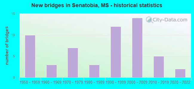
- New bridges - historical statistics
- 101950-1959
- 31960-1969
- 71970-1979
- 31980-1989
- 121990-1999
- 142000-2009
- 52010-2019
- 22020-2022


- Bridge Condition - Deck
- 17.9%Very good
- 35.9%Good
- 30.8%Satisfactory
- 15.4%Fair

- Bridge Condition - Superstructure
- 35.9%Very good
- 23.1%Good
- 30.8%Satisfactory
- 10.3%Fair

- Bridge Condition - Substructure
- 12.8%Very good
- 59.0%Good
- 17.9%Satisfactory
- 5.1%Fair
- 5.1%Poor

- Bridge Condition - Channel
- 20.5%Very good
- 56.8%Good
- 11.4%Satisfactory
- 11.4%Fair

- Bridge Condition - Culverts
- 45.5%Good
- 54.5%Satisfactory
Find on map >> Show street view
Structure Number: 11000550692641A, Location: 3.2 MI N PANOLA CL (Lat: 34.598964, Lng: -89.947603), Route carried "on" structure: Interstate 55, Year Built: 1959, Status: Open, Structure Length: 6.10m (20.01ft), Average Daily Traffic: 13,000 (year 2020), Truck Traffic: 23%, Average Future Daily Traffic: 16,500 (year 2040), Design Load: HS 20+Mod, Features Intersected: CANAL & SHANDS BOTTOM RD
Minimum Vertical Clearance: 30+ m (98+ ft), Kilometerpoint: 14.425, Lanes on structure: 2, Lanes under structure: 2, Base Highway Network: Yes (Inventory Route: 5, Subroute: 1), Owner: State Highway Agency, Approaching Roadway Width: 8.5m (27.9ft), Material/Design: Concrete, Design/Construction: Tee Beam, Number Of Spans In Main Unit: 5, Length of Maximum Span: 12.2m (40.0ft), Curb or Sidewalk Widths: Left: 0.5m (1.6ft), Right: 0.5m (1.6ft), Curb-To-Curb Width: 8.5m (27.9ft), Out-to-Out Width: 9.1m (29.9ft)
Condition: Deck: Satisfactory, Superstructure: Satisfactory, Substructure: Good, Channel: Good, Operating Rating: 69.2 metric tons, Method Used To Determine Operating Rating: Load Factor (LF), Inventory Rating: 41.5 metric tons, Method Used To Determine Inventory Rating: Load Factor (LF), Structural Evaluation: Equal to present minimum criteria, Deck Geometry: High priority of corrective action, Underclear: High priority of corrective action, Waterway Adequacy: Equal to present minimum criteria, Approach Roadway Alignment: Equal to present desirable criteria, Length Of Structure Improvement: 6.10m (20.01ft), Designated Inspection Frequency: Every 24 months, Inspection Date: March 2020, Bridge Improvement Cost: $184,000,000, Roadway Improvement Cost: $26,000,000, Total Project Cost: $210,000,000, Deck Structure Type: Concrete Cast-file-Place
Find on map >> Show street view
Structure Number: 11000550692641B, Location: 3.2 MI N PANOLA CL (Lat: 34.598544, Lng: -89.947303), Route carried "on" structure: Interstate 55, Year Built: 1959, Year Reconstructed: 2020, Status: Open, Structure Length: 6.10m (20.01ft), Average Daily Traffic: 13,000 (year 2020), Truck Traffic: 23%, Average Future Daily Traffic: 16,500 (year 2040), Design Load: HS 20+Mod, Features Intersected: CANAL & SHANDS BOTTOM RD
Minimum Vertical Clearance: 30+ m (98+ ft), Kilometerpoint: 5.119, Lanes on structure: 2, Lanes under structure: 2, Base Highway Network: Yes (Inventory Route: 5, Subroute: 1), Owner: State Highway Agency, Approaching Roadway Width: 8.5m (27.9ft), Skew: 3 degrees, Material/Design: Concrete, Design/Construction: Tee Beam, Number Of Spans In Main Unit: 5, Length of Maximum Span: 12.2m (40.0ft), Curb or Sidewalk Widths: Left: 0.5m (1.6ft), Right: 0.5m (1.6ft), Curb-To-Curb Width: 8.5m (27.9ft), Out-to-Out Width: 9.1m (29.9ft)
Condition: Deck: Very good, Superstructure: Good, Substructure: Good, Channel: Good, Operating Rating: 69.2 metric tons, Method Used To Determine Operating Rating: Load Factor (LF), Inventory Rating: 41.5 metric tons, Method Used To Determine Inventory Rating: Load Factor (LF), Structural Evaluation: Better than present minimum criteria, Deck Geometry: High priority of corrective action, Underclear: High priority of corrective action, Waterway Adequacy: Equal to present minimum criteria, Approach Roadway Alignment: Equal to present desirable criteria, Length Of Structure Improvement: 6.10m (20.01ft), Designated Inspection Frequency: Every 24 months, Inspection Date: March 2020, Bridge Improvement Cost: $184,000,000, Roadway Improvement Cost: $26,000,000, Total Project Cost: $210,000,000, Deck Structure Type: Concrete Cast-file-Place
Find on map >> Show street view
Structure Number: 11000550692655A, Location: I 55 OVER SR 4 (Lat: 34.619536, Lng: -89.951197), Route carried "on" structure: Interstate 55, Year Built: 1959, Status: Open, Structure Length: 6.77m (22.21ft), Average Daily Traffic: 13,000 (year 2020), Truck Traffic: 23%, Average Future Daily Traffic: 16,500 (year 2040), Design Load: HS 20+Mod, Features Intersected: SR 4
Minimum Vertical Clearance: 30+ m (98+ ft), Kilometerpoint: 12.109, Lanes on structure: 2, Lanes under structure: 3, Base Highway Network: Yes (Inventory Route: 5, Subroute: 1), Owner: State Highway Agency, Approaching Roadway Width: 8.5m (27.9ft), Material/Design: Concrete continuous, Design/Construction: Box Beam or Girders - Single/Spread, Number Of Spans In Main Unit: 3, Number Of Approach Spans: 2, Length of Maximum Span: 20.4m (66.9ft), Curb or Sidewalk Widths: Left: 0.5m (1.6ft), Right: 0.5m (1.6ft), Curb-To-Curb Width: 8.5m (27.9ft), Out-to-Out Width: 9.1m (29.9ft)
Condition: Deck: Fair, Superstructure: Fair, Substructure: Good, Operating Rating: 42.4 metric tons, Method Used To Determine Operating Rating: Load Factor (LF), Inventory Rating: 25.4 metric tons, Method Used To Determine Inventory Rating: Load Factor (LF), Structural Evaluation: Somewhat better than minimum adequacy, Deck Geometry: High priority of corrective action, Underclear: Equal to present minimum criteria, Approach Roadway Alignment: Equal to present desirable criteria, Length Of Structure Improvement: 6.77m (22.21ft), Designated Inspection Frequency: Every 24 months, Inspection Date: March 2020, Bridge Improvement Cost: $204,000,000, Roadway Improvement Cost: $26,000,000, Total Project Cost: $230,000,000, Deck Structure Type: Concrete Cast-file-Place
Find on map >> Show street view
Structure Number: 11000550692655B, Location: I 55 OVER SR 4 (Lat: 34.618883, Lng: -89.950739), Route carried "on" structure: Interstate 55, Year Built: 1959, Year Reconstructed: 2020, Status: Open, Structure Length: 6.77m (22.21ft), Average Daily Traffic: 13,000 (year 2020), Truck Traffic: 23%, Average Future Daily Traffic: 16,500 (year 2040), Design Load: HS 20+Mod, Features Intersected: SR 4
Minimum Vertical Clearance: 30+ m (98+ ft), Kilometerpoint: 7.406, Lanes on structure: 2, Lanes under structure: 3, Base Highway Network: Yes (Inventory Route: 5, Subroute: 1), Owner: State Highway Agency, Approaching Roadway Width: 8.5m (27.9ft), Material/Design: Concrete continuous, Design/Construction: Box Beam or Girders - Single/Spread, Number Of Spans In Main Unit: 3, Number Of Approach Spans: 2, Length of Maximum Span: 20.4m (66.9ft), Curb or Sidewalk Widths: Left: 0.5m (1.6ft), Right: 0.5m (1.6ft), Curb-To-Curb Width: 8.5m (27.9ft), Out-to-Out Width: 9.1m (29.9ft)
Condition: Deck: Very good, Superstructure: Satisfactory, Substructure: Good, Operating Rating: 42.4 metric tons, Method Used To Determine Operating Rating: Load Factor (LF), Inventory Rating: 25.4 metric tons, Method Used To Determine Inventory Rating: Load Factor (LF), Structural Evaluation: Equal to present minimum criteria, Deck Geometry: High priority of corrective action, Underclear: Equal to present minimum criteria, Approach Roadway Alignment: Equal to present desirable criteria, Length Of Structure Improvement: 6.77m (22.21ft), Designated Inspection Frequency: Every 24 months, Inspection Date: March 2020, Bridge Improvement Cost: $204,000,000, Roadway Improvement Cost: $26,000,000, Total Project Cost: $230,000,000, Deck Structure Type: Concrete Cast-file-Place
Find on map >> Show street view
Structure Number: 11000550692668A, Location: 1.3 MI N SR 4 (Lat: 34.638583, Lng: -89.956300), Route carried "on" structure: Interstate 55, Year Built: 1959, Status: Open, Structure Length: 15.85m (52.00ft), Average Daily Traffic: 16,000 (year 2020), Truck Traffic: 19%, Average Future Daily Traffic: 20,500 (year 2040), Design Load: HS 20+Mod, Features Intersected: HICKAHALA CREEK
Minimum Vertical Clearance: 30+ m (98+ ft), Kilometerpoint: 9.946, Lanes on structure: 2, Base Highway Network: Yes (Inventory Route: 5, Subroute: 1), Owner: State Highway Agency, Approaching Roadway Width: 8.5m (27.9ft), Material/Design: Concrete continuous, Design/Construction: Box Beam or Girders - Single/Spread, Number Of Spans In Main Unit: 3, Number Of Approach Spans: 5, Length of Maximum Span: 36.6m (120.1ft), Curb or Sidewalk Widths: Left: 0.5m (1.6ft), Right: 0.5m (1.6ft), Curb-To-Curb Width: 8.5m (27.9ft), Out-to-Out Width: 9.1m (29.9ft)
Condition: Deck: Fair, Superstructure: Satisfactory, Substructure: Poor, Channel: Good, Operating Rating: 69.2 metric tons, Method Used To Determine Operating Rating: Load Factor (LF), Inventory Rating: 41.5 metric tons, Method Used To Determine Inventory Rating: Load Factor (LF), Structural Evaluation: Meets minimum limits, Deck Geometry: High priority of corrective action, Waterway Adequacy: Equal to present minimum criteria, Approach Roadway Alignment: Equal to present desirable criteria, Length Of Structure Improvement: 15.85m (52.00ft), Designated Inspection Frequency: Every 24 months, Underwater Inspection Frequency: Every 30 months, Other Special Inspection Frequency: Every 24 months, Inspection Date: May 2020, Underwater Inspection Date: September 2019, Other Special Inspection Date: June 2021, Bridge Improvement Cost: $477,000,000, Roadway Improvement Cost: $26,000,000, Total Project Cost: $503,000,000, Deck Structure Type: Concrete Cast-file-Place
Find on map >> Show street view
Structure Number: 11000550692668B, Location: 1.3 MI N SR 4 (Lat: 34.637022, Lng: -89.955600), Route carried "on" structure: Interstate 55, Year Built: 1959, Status: Open, Structure Length: 15.85m (52.00ft), Average Daily Traffic: 16,000 (year 2020), Truck Traffic: 19%, Average Future Daily Traffic: 20,500 (year 2040), Design Load: HS 20+Mod, Features Intersected: HICKAHALA CREEK
Minimum Vertical Clearance: 30+ m (98+ ft), Kilometerpoint: 9.466, Lanes on structure: 2, Base Highway Network: Yes (Inventory Route: 5, Subroute: 1), Owner: State Highway Agency, Approaching Roadway Width: 8.5m (27.9ft), Material/Design: Concrete continuous, Design/Construction: Box Beam or Girders - Single/Spread, Number Of Spans In Main Unit: 3, Number Of Approach Spans: 5, Length of Maximum Span: 36.6m (120.1ft), Curb or Sidewalk Widths: Left: 0.5m (1.6ft), Right: 0.5m (1.6ft), Curb-To-Curb Width: 8.5m (27.9ft), Out-to-Out Width: 9.1m (29.9ft)
Condition: Deck: Fair, Superstructure: Fair, Substructure: Poor, Channel: Good, Operating Rating: 69.2 metric tons, Method Used To Determine Operating Rating: Load Factor (LF), Inventory Rating: 41.5 metric tons, Method Used To Determine Inventory Rating: Load Factor (LF), Structural Evaluation: Meets minimum limits, Deck Geometry: High priority of corrective action, Waterway Adequacy: Equal to present minimum criteria, Approach Roadway Alignment: Equal to present desirable criteria, Length Of Structure Improvement: 15.85m (52.00ft), Designated Inspection Frequency: Every 24 months, Underwater Inspection Frequency: Every 30 months, Other Special Inspection Frequency: Every 24 months, Inspection Date: May 2020, Underwater Inspection Date: September 2019, Other Special Inspection Date: June 2021, Bridge Improvement Cost: $477,000,000, Roadway Improvement Cost: $26,000,000, Total Project Cost: $503,000,000, Deck Structure Type: Concrete Cast-file-Place, Wearing Surface/Protective System: Wearing Surface: Other
Find on map >> Show street view
Structure Number: 11000550692676A, Location: 2.1 MI N SR 4 (Lat: 34.650067, Lng: -89.959378), Route carried "on" structure: Interstate 55, Year Built: 1959, Status: Open, Structure Length: 18.29m (60.01ft), Average Daily Traffic: 16,000 (year 2020), Truck Traffic: 19%, Average Future Daily Traffic: 20,500 (year 2040), Design Load: HS 20+Mod, Features Intersected: HICKAHALA RELIEF
Minimum Vertical Clearance: 30+ m (98+ ft), Kilometerpoint: 8.641, Lanes on structure: 2, Base Highway Network: Yes (Inventory Route: 5, Subroute: 1), Owner: State Highway Agency, Approaching Roadway Width: 8.5m (27.9ft), Material/Design: Concrete, Design/Construction: Tee Beam, Number Of Spans In Main Unit: 15, Length of Maximum Span: 12.2m (40.0ft), Curb or Sidewalk Widths: Left: 0.5m (1.6ft), Right: 0.5m (1.6ft), Curb-To-Curb Width: 8.5m (27.9ft), Out-to-Out Width: 9.1m (29.9ft)
Condition: Deck: Fair, Superstructure: Fair, Substructure: Good, Channel: Very good, Operating Rating: 71.6 metric tons, Method Used To Determine Operating Rating: Load Factor (LF), Inventory Rating: 43.0 metric tons, Method Used To Determine Inventory Rating: Load Factor (LF), Structural Evaluation: Somewhat better than minimum adequacy, Deck Geometry: High priority of corrective action, Waterway Adequacy: Equal to present minimum criteria, Approach Roadway Alignment: Equal to present desirable criteria, Length Of Structure Improvement: 22.57m (74.05ft), Designated Inspection Frequency: Every 24 months, Inspection Date: May 2020, Bridge Improvement Cost: $999,999,000, Roadway Improvement Cost: $218,000,000, Total Project Cost: $999,999,000, Deck Structure Type: Concrete Cast-file-Place
Find on map >> Show street view
Structure Number: 11000550692676B, Location: 2.1 MI N SR 4 (Lat: 34.648511, Lng: -89.958675), Route carried "on" structure: Interstate 55, Year Built: 1959, Status: Open, Structure Length: 18.29m (60.01ft), Average Daily Traffic: 16,000 (year 2020), Truck Traffic: 19%, Average Future Daily Traffic: 20,500 (year 2040), Design Load: HS 20+Mod, Features Intersected: HICKAHALA RELIEF
Minimum Vertical Clearance: 30+ m (98+ ft), Kilometerpoint: 10.771, Lanes on structure: 2, Base Highway Network: Yes (Inventory Route: 5, Subroute: 1), Owner: State Highway Agency, Approaching Roadway Width: 8.5m (27.9ft), Material/Design: Concrete, Design/Construction: Tee Beam, Number Of Spans In Main Unit: 15, Length of Maximum Span: 12.2m (40.0ft), Curb or Sidewalk Widths: Left: 0.5m (1.6ft), Right: 0.5m (1.6ft), Curb-To-Curb Width: 8.5m (27.9ft), Out-to-Out Width: 9.1m (29.9ft)
Condition: Deck: Satisfactory, Superstructure: Satisfactory, Substructure: Good, Channel: Good, Operating Rating: 69.2 metric tons, Method Used To Determine Operating Rating: Load Factor (LF), Inventory Rating: 41.5 metric tons, Method Used To Determine Inventory Rating: Load Factor (LF), Structural Evaluation: Equal to present minimum criteria, Deck Geometry: High priority of corrective action, Waterway Adequacy: Equal to present minimum criteria, Approach Roadway Alignment: Equal to present desirable criteria, Length Of Structure Improvement: 22.57m (74.05ft), Designated Inspection Frequency: Every 24 months, Inspection Date: May 2020, Bridge Improvement Cost: $999,999,000, Roadway Improvement Cost: $218,000,000, Total Project Cost: $999,999,000, Deck Structure Type: Concrete Cast-file-Place, Wearing Surface/Protective System: Wearing Surface: Other
Find on map >> Show street view
Structure Number: 21000510692666, Location: 0.1 MI N PANOLA CL (Lat: 34.553956, Lng: -89.966081), Route carried "on" structure: US 51, Year Built: 1998, Status: Open, Structure Length: 7.65m (25.10ft), Average Daily Traffic: 7,200 (year 2020), Truck Traffic: 5%, Average Future Daily Traffic: 7,200 (year 2040), Design Load: HS 20, Features Intersected: PORTERS CREEK
Minimum Vertical Clearance: 30+ m (98+ ft), Kilometerpoint: 0.003, Lanes on structure: 2, Owner: State Highway Agency, Approaching Roadway Width: 12.2m (40.0ft), Material/Design: Prestressed concrete, Design/Construction: Stringer/Multi-beam, Number Of Spans In Main Unit: 1, Number Of Approach Spans: 4, Length of Maximum Span: 24.0m (78.7ft), Curb-To-Curb Width: 12.2m (40.0ft), Out-to-Out Width: 12.9m (42.3ft)
Condition: Deck: Good, Superstructure: Good, Substructure: Good, Channel: Satisfactory, Operating Rating: 68.5 metric tons, Method Used To Determine Operating Rating: Load Factor (LF), Inventory Rating: 34.4 metric tons, Method Used To Determine Inventory Rating: Load Factor (LF), Structural Evaluation: Better than present minimum criteria, Deck Geometry: Somewhat better than minimum adequacy, Waterway Adequacy: Equal to present desirable criteria, Approach Roadway Alignment: Equal to present desirable criteria, Designated Inspection Frequency: Every 24 months, Inspection Date: October 2020, Deck Structure Type: Concrete Cast-file-Place
Find on map >> Show street view
Structure Number: 21000510692732A, Location: 1.5 MI N SR 4 (Lat: 34.647792, Lng: -89.972222), Route carried "on" structure: US 51, Year Built: 2013, Status: Open, Structure Length: 7.25m (23.79ft), Average Daily Traffic: 9,000 (year 2020), Truck Traffic: 11%, Average Future Daily Traffic: 9,000 (year 2040), Design Load: HS 20, Features Intersected: HICKAHALA CREEK RELIEF
Minimum Vertical Clearance: 30+ m (98+ ft), Kilometerpoint: 10.475, Lanes on structure: 2, Owner: State Highway Agency, Approaching Roadway Width: 12.0m (39.4ft), Material/Design: Prestressed concrete continuous, Design/Construction: Stringer/Multi-beam, Number Of Spans In Main Unit: 6, Length of Maximum Span: 12.0m (39.4ft), Curb-To-Curb Width: 12.0m (39.4ft), Out-to-Out Width: 12.9m (42.3ft)
Condition: Deck: Good, Superstructure: Very good, Substructure: Very good, Channel: Good, Operating Rating: 67.7 metric tons, Method Used To Determine Operating Rating: Load Factor (LF), Inventory Rating: 40.5 metric tons, Method Used To Determine Inventory Rating: Load Factor (LF), Structural Evaluation: Equal to present desirable criteria, Deck Geometry: Somewhat better than minimum adequacy, Waterway Adequacy: Equal to present desirable criteria, Approach Roadway Alignment: Equal to present desirable criteria, Designated Inspection Frequency: Every 24 months, Inspection Date: September 2021, Deck Structure Type: Concrete Cast-file-Place
Find on map >> Show street view
Structure Number: 21000510692735A, Location: 1.8 MI N SR 4 (Lat: 34.652058, Lng: -89.973319), Route carried "on" structure: US 51, Year Built: 2013, Status: Open, Structure Length: 8.45m (27.72ft), Average Daily Traffic: 9,000 (year 2020), Truck Traffic: 11%, Average Future Daily Traffic: 9,000 (year 2040), Design Load: HS 20, Features Intersected: HICKAHALA CREEK RELIEF
Minimum Vertical Clearance: 30+ m (98+ ft), Kilometerpoint: 10.960, Lanes on structure: 2, Owner: State Highway Agency, Approaching Roadway Width: 12.0m (39.4ft), Material/Design: Prestressed concrete continuous, Design/Construction: Stringer/Multi-beam, Number Of Spans In Main Unit: 7, Length of Maximum Span: 12.0m (39.4ft), Curb-To-Curb Width: 12.0m (39.4ft), Out-to-Out Width: 12.9m (42.3ft)
Condition: Deck: Good, Superstructure: Very good, Substructure: Good, Channel: Very good, Operating Rating: 67.7 metric tons, Method Used To Determine Operating Rating: Load Factor (LF), Inventory Rating: 40.5 metric tons, Method Used To Determine Inventory Rating: Load Factor (LF), Structural Evaluation: Better than present minimum criteria, Deck Geometry: Somewhat better than minimum adequacy, Waterway Adequacy: Equal to present desirable criteria, Approach Roadway Alignment: Equal to present desirable criteria, Designated Inspection Frequency: Every 24 months, Inspection Date: September 2021, Deck Structure Type: Concrete Cast-file-Place
Find on map >> Show street view
Structure Number: 21000510692737A, Location: 1.9 MI N SR 4 (Lat: 34.653817, Lng: -89.973772), Route carried "on" structure: US 51, Year Built: 2013, Status: Open, Structure Length: 9.07m (29.76ft), Average Daily Traffic: 9,000 (year 2020), Truck Traffic: 11%, Average Future Daily Traffic: 9,000 (year 2040), Design Load: HS 20, Features Intersected: HICKAHALA CREEK
Minimum Vertical Clearance: 30+ m (98+ ft), Kilometerpoint: 11.159, Lanes on structure: 2, Owner: State Highway Agency, Approaching Roadway Width: 12.0m (39.4ft), Material/Design: Prestressed concrete continuous, Design/Construction: Stringer/Multi-beam, Number Of Spans In Main Unit: 3, Length of Maximum Span: 30.0m (98.4ft), Curb-To-Curb Width: 12.0m (39.4ft), Out-to-Out Width: 12.9m (42.3ft)
Condition: Deck: Good, Superstructure: Very good, Substructure: Very good, Channel: Very good, Operating Rating: 83.6 metric tons, Method Used To Determine Operating Rating: Load Factor (LF), Inventory Rating: 37.1 metric tons, Method Used To Determine Inventory Rating: Load Factor (LF), Structural Evaluation: Equal to present desirable criteria, Deck Geometry: Somewhat better than minimum adequacy, Waterway Adequacy: Equal to present desirable criteria, Approach Roadway Alignment: Equal to present desirable criteria, Designated Inspection Frequency: Every 24 months, Inspection Date: September 2021, Deck Structure Type: Concrete Cast-file-Place
Find on map >> Show street view
Structure Number: 31000040690352, Location: 4.3 MI W US 51 (Lat: 34.619156, Lng: -90.043367), Route carried "on" structure: State highway 4, Year Built: 2013, Status: Open, Structure Length: 5.54m (18.18ft), Average Daily Traffic: 4,900 (year 2020), Truck Traffic: 9%, Average Future Daily Traffic: 4,900 (year 2040), Design Load: HL 93, Features Intersected: SMITH DITCH
Minimum Vertical Clearance: 30+ m (98+ ft), Kilometerpoint: 15.202, Lanes on structure: 2, Owner: State Highway Agency, Approaching Roadway Width: 12.2m (40.0ft), Material/Design: Prestressed concrete, Design/Construction: Stringer/Multi-beam, Number Of Spans In Main Unit: 1, Number Of Approach Spans: 2, Length of Maximum Span: 30.5m (100.1ft), Curb-To-Curb Width: 12.2m (40.0ft), Out-to-Out Width: 13.0m (42.7ft)
Condition: Deck: Very good, Superstructure: Very good, Substructure: Very good, Channel: Very good, Operating Rating: 53.9 metric tons, Method Used To Determine Operating Rating: Load and Resistance Factor (LRFR), Inventory Rating: 38.6 metric tons, Method Used To Determine Inventory Rating: Load and Resistance Factor (LRFR), Structural Evaluation: Equal to present desirable criteria, Deck Geometry: Equal to present minimum criteria, Waterway Adequacy: Equal to present desirable criteria, Approach Roadway Alignment: Equal to present desirable criteria, Designated Inspection Frequency: Every 24 months, Inspection Date: August 2021, Deck Structure Type: Concrete Cast-file-Place
Find on map >> Show street view
Structure Number: 31000040690358, Location: 3.7 MI W US 51 (Lat: 34.619153, Lng: -90.034181), Route carried "on" structure: State highway 4, Year Built: 2013, Status: Open, Structure Length: 9.21m (30.22ft), Average Daily Traffic: 4,900 (year 2020), Truck Traffic: 9%, Average Future Daily Traffic: 4,900 (year 2040), Design Load: HL 93, Features Intersected: ARKABUTLA CREEK
Minimum Vertical Clearance: 30+ m (98+ ft), Kilometerpoint: 16.044, Lanes on structure: 2, Owner: State Highway Agency, Approaching Roadway Width: 12.2m (40.0ft), Skew: 1 degrees, Material/Design: Prestressed concrete continuous, Design/Construction: Stringer/Multi-beam, Number Of Spans In Main Unit: 3, Length of Maximum Span: 30.5m (100.1ft), Curb-To-Curb Width: 12.2m (40.0ft), Out-to-Out Width: 13.0m (42.7ft)
Condition: Deck: Very good, Superstructure: Very good, Substructure: Very good, Channel: Very good, Operating Rating: 55.1 metric tons, Method Used To Determine Operating Rating: Load and Resistance Factor (LRFR), Inventory Rating: 40.3 metric tons, Method Used To Determine Inventory Rating: Load and Resistance Factor (LRFR), Structural Evaluation: Equal to present desirable criteria, Deck Geometry: Equal to present minimum criteria, Waterway Adequacy: Equal to present desirable criteria, Approach Roadway Alignment: Equal to present desirable criteria, Designated Inspection Frequency: Every 24 months, Inspection Date: August 2021, Deck Structure Type: Concrete Cast-file-Place
Find on map >> Show street view
Structure Number: 31000040690407, Location: 0.2 MI E I 55 (Lat: 34.618558, Lng: -89.948264), Route carried "on" structure: State highway 4, Year Built: 1974, Status: Open, Structure Length: 5.58m (18.31ft), Average Daily Traffic: 7,300 (year 2020), Truck Traffic: 11%, Average Future Daily Traffic: 7,300 (year 2040), Design Load: HS 20, Features Intersected: WEST CANAL
Minimum Vertical Clearance: 30+ m (98+ ft), Kilometerpoint: 25.402, Lanes on structure: 2, Owner: State Highway Agency, Approaching Roadway Width: 11.7m (38.4ft), Skew: 3 degrees, Material/Design: Prestressed concrete continuous, Design/Construction: Stringer/Multi-beam, Number Of Spans In Main Unit: 3, Length of Maximum Span: 18.3m (60.0ft), Curb-To-Curb Width: 11.7m (38.4ft), Out-to-Out Width: 12.7m (41.7ft)
Condition: Deck: Satisfactory, Superstructure: Satisfactory, Substructure: Satisfactory, Channel: Good, Operating Rating: 65.6 metric tons, Method Used To Determine Operating Rating: Load Factor (LF), Inventory Rating: 39.6 metric tons, Method Used To Determine Inventory Rating: Load Factor (LF), Structural Evaluation: Equal to present minimum criteria, Deck Geometry: Somewhat better than minimum adequacy, Waterway Adequacy: Equal to present desirable criteria, Approach Roadway Alignment: Equal to present desirable criteria, Designated Inspection Frequency: Every 24 months, Inspection Date: October 2020, Deck Structure Type: Concrete Cast-file-Place
Find on map >> Show street view
Structure Number: 31000040690408, Location: 0.3 MI E I 55 (Lat: 34.618131, Lng: -89.946697), Route carried "on" structure: State highway 4, Year Built: 1974, Status: Open, Structure Length: 3.72m (12.20ft), Average Daily Traffic: 7,300 (year 2020), Truck Traffic: 11%, Average Future Daily Traffic: 7,300 (year 2040), Design Load: HS 20, Features Intersected: RELIEF
Minimum Vertical Clearance: 30+ m (98+ ft), Kilometerpoint: 25.553, Lanes on structure: 2, Owner: State Highway Agency, Approaching Roadway Width: 11.7m (38.4ft), Material/Design: Prestressed concrete continuous, Design/Construction: Stringer/Multi-beam, Number Of Spans In Main Unit: 3, Length of Maximum Span: 12.2m (40.0ft), Curb-To-Curb Width: 11.7m (38.4ft), Out-to-Out Width: 12.7m (41.7ft)
Condition: Deck: Good, Superstructure: Good, Substructure: Good, Channel: Very good, Operating Rating: 65.9 metric tons, Method Used To Determine Operating Rating: Load Factor (LF), Inventory Rating: 39.5 metric tons, Method Used To Determine Inventory Rating: Load Factor (LF), Structural Evaluation: Better than present minimum criteria, Deck Geometry: Somewhat better than minimum adequacy, Waterway Adequacy: Equal to present desirable criteria, Approach Roadway Alignment: Equal to present desirable criteria, Designated Inspection Frequency: Every 24 months, Inspection Date: October 2020, Deck Structure Type: Concrete Cast-file-Place
Find on map >> Show street view
Structure Number: 31000040690411, Location: 0.6 MI E I 55 (Lat: 34.616736, Lng: -89.941567), Route carried "on" structure: State highway 4, Year Built: 1974, Status: Open, Structure Length: 7.41m (24.31ft), Average Daily Traffic: 7,300 (year 2020), Truck Traffic: 11%, Average Future Daily Traffic: 7,300 (year 2040), Design Load: HS 20, Features Intersected: SENATOBIA CREEK
Minimum Vertical Clearance: 30+ m (98+ ft), Kilometerpoint: 26.047, Lanes on structure: 2, Owner: State Highway Agency, Approaching Roadway Width: 11.7m (38.4ft), Skew: 4 degrees, Material/Design: Prestressed concrete continuous, Design/Construction: Stringer/Multi-beam, Number Of Spans In Main Unit: 3, Length of Maximum Span: 30.5m (100.1ft), Curb-To-Curb Width: 11.7m (38.4ft), Out-to-Out Width: 12.7m (41.7ft)
Condition: Deck: Good, Superstructure: Satisfactory, Substructure: Good, Channel: Good, Operating Rating: 83.2 metric tons, Method Used To Determine Operating Rating: Load Factor (LF), Inventory Rating: 35.1 metric tons, Method Used To Determine Inventory Rating: Load Factor (LF), Structural Evaluation: Equal to present minimum criteria, Deck Geometry: Somewhat better than minimum adequacy, Waterway Adequacy: Equal to present desirable criteria, Approach Roadway Alignment: Equal to present desirable criteria, Designated Inspection Frequency: Every 24 months, Inspection Date: October 2020, Deck Structure Type: Concrete Cast-file-Place
Find on map >> Show street view
Structure Number: 31000040690414, Location: 0.9 MI E I 55 (Lat: 34.615575, Lng: -89.937314), Route carried "on" structure: State highway 4, Year Built: 1974, Status: Open, Structure Length: 1.31m (4.30ft), Average Daily Traffic: 7,300 (year 2020), Truck Traffic: 11%, Average Future Daily Traffic: 7,300 (year 2040), Design Load: HS 20, Features Intersected: EAST CANAL
Minimum Vertical Clearance: 30+ m (98+ ft), Kilometerpoint: 26.458, Lanes on structure: 2, Owner: State Highway Agency, Approaching Roadway Width: 12.2m (40.0ft), Skew: 3 degrees, Material/Design: Concrete, Design/Construction: Culvert, Number Of Spans In Main Unit: 2, Length of Maximum Span: 6.1m (20.0ft)
Condition: Channel: Good, Culverts: Good, Operating Rating: 68.2 metric tons, Method Used To Determine Operating Rating: Load Factor (LF), Inventory Rating: 40.9 metric tons, Method Used To Determine Inventory Rating: Load Factor (LF), Structural Evaluation: Better than present minimum criteria, Waterway Adequacy: Equal to present desirable criteria, Approach Roadway Alignment: Equal to present desirable criteria, Designated Inspection Frequency: Every 48 months, Inspection Date: December 2020
Find on map >> Show street view
Structure Number: 31000040690436, Location: 3.1 MI E I 55 (Lat: 34.611897, Lng: -89.898864), Route carried "on" structure: State highway 4, Year Built: 1974, Status: Open, Structure Length: 1.31m (4.30ft), Average Daily Traffic: 5,700 (year 2020), Truck Traffic: 6%, Average Future Daily Traffic: 5,700 (year 2040), Design Load: HS 20, Features Intersected: BASKET CREEK
Minimum Vertical Clearance: 30+ m (98+ ft), Kilometerpoint: 30.030, Lanes on structure: 2, Base Highway Network: Yes (, Subroute: 1), Owner: State Highway Agency, Approaching Roadway Width: 12.2m (40.0ft), Material/Design: Concrete, Design/Construction: Culvert, Number Of Spans In Main Unit: 2, Length of Maximum Span: 6.1m (20.0ft)
Condition: Channel: Good, Culverts: Satisfactory, Operating Rating: 70.7 metric tons, Method Used To Determine Operating Rating: Load Factor (LF), Inventory Rating: 42.4 metric tons, Method Used To Determine Inventory Rating: Load Factor (LF), Structural Evaluation: Equal to present minimum criteria, Waterway Adequacy: Equal to present desirable criteria, Approach Roadway Alignment: Equal to present desirable criteria, Designated Inspection Frequency: Every 24 months, Inspection Date: October 2020
Find on map >> Show street view
Structure Number: 31007400690400A, Location: 0.6 MI W I 55 (Lat: 34.587894, Lng: -89.956714), Route carried "on" structure: State highway 740, Year Built: 2006, Status: Open, Structure Length: 9.37m (30.74ft), Average Daily Traffic: 2,600 (year 2020), Truck Traffic: 9%, Average Future Daily Traffic: 2,950 (year 2040), Design Load: HS 20, Features Intersected: CNIC RR
Minimum Vertical Clearance: 30+ m (98+ ft), Kilometerpoint: 1.337, Lanes on structure: 2, Base Highway Network: Yes (Inventory Route: 74, Subroute: 1), Owner: State Highway Agency, Approaching Roadway Width: 12.0m (39.4ft), Material/Design: Prestressed concrete continuous, Design/Construction: Stringer/Multi-beam, Number Of Spans In Main Unit: 3, Length of Maximum Span: 31.0m (101.7ft), Curb-To-Curb Width: 12.0m (39.4ft), Out-to-Out Width: 12.9m (42.3ft)
Condition: Deck: Good, Superstructure: Very good, Substructure: Good, Operating Rating: 66.5 metric tons, Method Used To Determine Operating Rating: Load Factor (LF), Inventory Rating: 27.2 metric tons, Method Used To Determine Inventory Rating: Load Factor (LF), Structural Evaluation: Equal to present minimum criteria, Deck Geometry: Better than present minimum criteria, Underclear: Superior to present desirable criteria, Approach Roadway Alignment: Equal to present desirable criteria, Designated Inspection Frequency: Every 24 months, Inspection Date: October 2020, Deck Structure Type: Concrete Cast-file-Place
Find on map >> Show street view
Structure Number: 31007400690400B, Location: 0.6 MI W I 55 (Lat: 34.587481, Lng: -89.957672), Route carried "on" structure: State highway 740, Year Built: 2006, Status: Open, Structure Length: 9.37m (30.74ft), Average Daily Traffic: 2,600 (year 2020), Truck Traffic: 9%, Average Future Daily Traffic: 2,950 (year 2040), Design Load: HS 20, Features Intersected: CNIC RR
Minimum Vertical Clearance: 30+ m (98+ ft), Kilometerpoint: 1.014, Lanes on structure: 2, Base Highway Network: Yes (Inventory Route: 74, Subroute: 1), Owner: State Highway Agency, Approaching Roadway Width: 12.0m (39.4ft), Material/Design: Prestressed concrete continuous, Design/Construction: Stringer/Multi-beam, Number Of Spans In Main Unit: 3, Length of Maximum Span: 31.0m (101.7ft), Curb-To-Curb Width: 12.0m (39.4ft), Out-to-Out Width: 12.9m (42.3ft)
Condition: Deck: Good, Superstructure: Very good, Substructure: Good, Operating Rating: 66.5 metric tons, Method Used To Determine Operating Rating: Load Factor (LF), Inventory Rating: 27.2 metric tons, Method Used To Determine Inventory Rating: Load Factor (LF), Structural Evaluation: Equal to present minimum criteria, Deck Geometry: Better than present minimum criteria, Underclear: Superior to present desirable criteria, Approach Roadway Alignment: Equal to present desirable criteria, Designated Inspection Frequency: Every 24 months, Inspection Date: October 2020, Deck Structure Type: Concrete Cast-file-Place
Find on map >> Show street view
Structure Number: 31007400690402A, Location: 0.3 MI W I 55 (Lat: 34.588019, Lng: -89.951411), Route carried "on" structure: State highway 740, Year Built: 2006, Status: Open, Structure Length: 9.07m (29.76ft), Average Daily Traffic: 2,600 (year 2020), Truck Traffic: 9%, Average Future Daily Traffic: 2,950 (year 2040), Design Load: HS 20, Features Intersected: WEST DITCH
Minimum Vertical Clearance: 30+ m (98+ ft), Kilometerpoint: 0.853, Lanes on structure: 2, Base Highway Network: Yes (Inventory Route: 74, Subroute: 1), Owner: State Highway Agency, Approaching Roadway Width: 12.0m (39.4ft), Skew: 1 degrees, Material/Design: Prestressed concrete, Design/Construction: Stringer/Multi-beam, Number Of Spans In Main Unit: 1, Number Of Approach Spans: 3, Length of Maximum Span: 30.0m (98.4ft), Curb-To-Curb Width: 12.0m (39.4ft), Out-to-Out Width: 12.9m (42.3ft)
Condition: Deck: Very good, Superstructure: Very good, Substructure: Good, Channel: Very good, Operating Rating: 66.1 metric tons, Method Used To Determine Operating Rating: Load Factor (LF), Inventory Rating: 27.7 metric tons, Method Used To Determine Inventory Rating: Load Factor (LF), Structural Evaluation: Equal to present minimum criteria, Deck Geometry: Better than present minimum criteria, Waterway Adequacy: Equal to present desirable criteria, Approach Roadway Alignment: Equal to present desirable criteria, Designated Inspection Frequency: Every 24 months, Inspection Date: October 2020, Deck Structure Type: Concrete Cast-file-Place
Find on map >> Show street view
Structure Number: 31007400690402B, Location: 0.3 MI W I 55 (Lat: 34.587644, Lng: -89.952550), Route carried "on" structure: State highway 740, Year Built: 2006, Status: Open, Structure Length: 9.07m (29.76ft), Average Daily Traffic: 2,600 (year 2020), Truck Traffic: 9%, Average Future Daily Traffic: 2,950 (year 2040), Design Load: HS 20, Features Intersected: WEST DITCH
Minimum Vertical Clearance: 30+ m (98+ ft), Kilometerpoint: 1.489, Lanes on structure: 2, Base Highway Network: Yes (Inventory Route: 74, Subroute: 1), Owner: State Highway Agency, Approaching Roadway Width: 12.0m (39.4ft), Skew: 1 degrees, Material/Design: Prestressed concrete, Design/Construction: Stringer/Multi-beam, Number Of Spans In Main Unit: 1, Number Of Approach Spans: 3, Length of Maximum Span: 30.0m (98.4ft), Curb-To-Curb Width: 12.0m (39.4ft), Out-to-Out Width: 12.9m (42.3ft)
Condition: Deck: Very good, Superstructure: Very good, Substructure: Good, Channel: Good, Operating Rating: 66.1 metric tons, Method Used To Determine Operating Rating: Load Factor (LF), Inventory Rating: 27.7 metric tons, Method Used To Determine Inventory Rating: Load Factor (LF), Structural Evaluation: Equal to present minimum criteria, Deck Geometry: Better than present minimum criteria, Waterway Adequacy: Equal to present desirable criteria, Approach Roadway Alignment: Equal to present desirable criteria, Designated Inspection Frequency: Every 24 months, Inspection Date: October 2020, Deck Structure Type: Concrete Cast-file-Place
Find on map >> Show street view
Structure Number: 31007400690405A, Location: SR 740 OVER I 55 (Lat: 34.588186, Lng: -89.946525), Route carried "on" structure: State highway 740, Year Built: 2006, Status: Open, Structure Length: 10.07m (33.04ft), Average Daily Traffic: 2,600 (year 2020), Truck Traffic: 9%, Average Future Daily Traffic: 2,950 (year 2040), Design Load: HS 20, Features Intersected: I 55
Minimum Vertical Clearance: 30+ m (98+ ft), Kilometerpoint: 0.402, Lanes on structure: 2, Lanes under structure: 4, Base Highway Network: Yes (Inventory Route: 74, Subroute: 1), Owner: State Highway Agency, Approaching Roadway Width: 12.0m (39.4ft), Material/Design: Prestressed concrete continuous, Design/Construction: Stringer/Multi-beam, Number Of Spans In Main Unit: 4, Length of Maximum Span: 30.0m (98.4ft), Curb-To-Curb Width: 12.0m (39.4ft), Out-to-Out Width: 12.9m (42.3ft)
Condition: Deck: Very good, Superstructure: Very good, Substructure: Good, Operating Rating: 66.3 metric tons, Method Used To Determine Operating Rating: Load Factor (LF), Inventory Rating: 28.8 metric tons, Method Used To Determine Inventory Rating: Load Factor (LF), Structural Evaluation: Better than present minimum criteria, Deck Geometry: Better than present minimum criteria, Underclear: Better than present minimum criteria, Approach Roadway Alignment: Equal to present desirable criteria, Designated Inspection Frequency: Every 24 months, Inspection Date: October 2020, Deck Structure Type: Concrete Cast-file-Place
Find on map >> Show street view
Structure Number: 31007400690405B, Location: SR 740 OVER I 55 (Lat: 34.587803, Lng: -89.947664), Route carried "on" structure: State highway 740, Year Built: 2006, Status: Open, Structure Length: 10.07m (33.04ft), Average Daily Traffic: 2,600 (year 2020), Truck Traffic: 9%, Average Future Daily Traffic: 2,950 (year 2040), Design Load: HS 20, Features Intersected: I 55
Minimum Vertical Clearance: 30+ m (98+ ft), Kilometerpoint: 1.942, Lanes on structure: 2, Lanes under structure: 4, Base Highway Network: Yes (Inventory Route: 74, Subroute: 1), Owner: State Highway Agency, Approaching Roadway Width: 12.0m (39.4ft), Material/Design: Prestressed concrete continuous, Design/Construction: Stringer/Multi-beam, Number Of Spans In Main Unit: 4, Length of Maximum Span: 30.0m (98.4ft), Curb-To-Curb Width: 12.0m (39.4ft), Out-to-Out Width: 12.9m (42.3ft)
Condition: Deck: Good, Superstructure: Very good, Substructure: Good, Operating Rating: 66.3 metric tons, Method Used To Determine Operating Rating: Load Factor (LF), Inventory Rating: 28.8 metric tons, Method Used To Determine Inventory Rating: Load Factor (LF), Structural Evaluation: Better than present minimum criteria, Deck Geometry: Better than present minimum criteria, Underclear: Equal to present minimum criteria, Approach Roadway Alignment: Equal to present desirable criteria, Designated Inspection Frequency: Every 24 months, Inspection Date: October 2020, Deck Structure Type: Concrete Cast-file-Place
Find on map >> Show street view
Structure Number: SA5400000000014, Location: SEC_22_T 6S_R 8W B (Lat: 34.554108, Lng: -90.032142), Route carried "on" structure: County highway 128, Year Built: 1998, Status: Open, Structure Length: 5.49m (18.01ft), Average Daily Traffic: 80 (year 2018), Average Future Daily Traffic: 120 (year 2038), Design Load: HS 20, Features Intersected: BUTTERBOWL CREEK, Facility Carried by Structure: TATE-PANOLA CO LIN
Minimum Vertical Clearance: 30+ m (98+ ft), Kilometerpoint: 2.253, Lanes on structure: 2, Owner: County Highway Agency, Approaching Roadway Width: 8.5m (27.9ft), Skew: 4 degrees, Material/Design: Prestressed concrete, Design/Construction: Stringer/Multi-beam, Number Of Spans In Main Unit: 3, Length of Maximum Span: 30.5m (100.1ft), Curb or Sidewalk Widths: Left: 0.5m (1.6ft), Right: 0.5m (1.6ft), Curb-To-Curb Width: 8.5m (27.9ft), Out-to-Out Width: 9.5m (31.2ft)
Condition: Deck: Good, Superstructure: Very good, Substructure: Very good, Channel: Good, Operating Rating: 54.1 metric tons, Method Used To Determine Operating Rating: Load Factor (LF) rating reported by rating factor (RF) method using MS18 loading, Inventory Rating: 28.2 metric tons, Method Used To Determine Inventory Rating: Load Factor (LF) rating reported by rating factor (RF) method using MS18 loading, Structural Evaluation: Better than present minimum criteria, Deck Geometry: Better than present minimum criteria, Waterway Adequacy: Equal to present desirable criteria, Approach Roadway Alignment: Equal to present desirable criteria, Designated Inspection Frequency: Every 24 months, Inspection Date: December 2020, Deck Structure Type: Concrete Cast-file-Place, Wearing Surface/Protective System: Wearing Surface: Monolithic Concrete
Find on map >> Show street view
Structure Number: SA5400000000016, Location: SEC 23 T 6S R 8W B (Lat: 34.553969, Lng: -90.009072), Route carried "on" structure: County highway 129, Year Built: 1991, Status: Open, Structure Length: 1.22m (4.00ft), Average Daily Traffic: 80 (year 2018), Average Future Daily Traffic: 120 (year 2038), Design Load: HS 20, Features Intersected: CREEK, Facility Carried by Structure: TATE-PANOLA CO LIN
Minimum Vertical Clearance: 30+ m (98+ ft), Kilometerpoint: 4.345, Lanes on structure: 2, Owner: County Highway Agency, Approaching Roadway Width: 9.1m (29.9ft), Skew: 3 degrees, Material/Design: Concrete, Design/Construction: Culvert, Number Of Spans In Main Unit: 2, Length of Maximum Span: 4.9m (16.1ft)
Condition: Channel: Good, Culverts: Satisfactory, Operating Rating: 54.1 metric tons, Method Used To Determine Operating Rating: Load Factor (LF) rating reported by rating factor (RF) method using MS18 loading, Inventory Rating: 32.4 metric tons, Method Used To Determine Inventory Rating: Load Factor (LF) rating reported by rating factor (RF) method using MS18 loading, Structural Evaluation: Equal to present minimum criteria, Waterway Adequacy: Equal to present desirable criteria, Approach Roadway Alignment: Equal to present desirable criteria, Designated Inspection Frequency: Every 24 months, Inspection Date: December 2020
Find on map >> Show street view
Structure Number: SA5400000000017, Location: SEC 24 T 6S R 8W B (Lat: 34.549019, Lng: -90.003983), Route carried "on" structure: County highway 128, Year Built: 1994, Status: Open, Structure Length: 1.49m (4.89ft), Average Daily Traffic: 100 (year 2018), Truck Traffic: 8%, Average Future Daily Traffic: 150 (year 2038), Design Load: HS 20, Features Intersected: CREEK, Facility Carried by Structure: HAMMOND HILL RD.
Minimum Vertical Clearance: 30+ m (98+ ft), Kilometerpoint: 4.184, Lanes on structure: 2, Owner: County Highway Agency, Approaching Roadway Width: 9.1m (29.9ft), Skew: 4 degrees, Material/Design: Concrete, Design/Construction: Culvert, Number Of Spans In Main Unit: 2, Length of Maximum Span: 4.9m (16.1ft)
Condition: Channel: Fair, Culverts: Satisfactory, Operating Rating: 54.1 metric tons, Method Used To Determine Operating Rating: Load Factor (LF) rating reported by rating factor (RF) method using MS18 loading, Inventory Rating: 32.4 metric tons, Method Used To Determine Inventory Rating: Load Factor (LF) rating reported by rating factor (RF) method using MS18 loading, Structural Evaluation: Equal to present minimum criteria, Waterway Adequacy: Equal to present desirable criteria, Approach Roadway Alignment: Equal to present desirable criteria, Designated Inspection Frequency: Every 24 months, Inspection Date: December 2020
Find on map >> Show street view
Structure Number: SA6900000000001, Location: SEC 5 T 4S R 5W (Lat: 34.769311, Lng: -89.754208), Route carried "on" structure: County highway 130, Year Built: 2002, Status: Open, Structure Length: 0.92m (3.02ft), Average Daily Traffic: 80 (year 2018), Average Future Daily Traffic: 120 (year 2038), Design Load: HS 20, Features Intersected: PIDGEON ROOST CK BRANCH, Facility Carried by Structure: PIDGEON ROOST ROAD
Minimum Vertical Clearance: 30+ m (98+ ft), Kilometerpoint: 2.896, Lanes on structure: 2, Owner: County Highway Agency, Approaching Roadway Width: 8.5m (27.9ft), Skew: 3 degrees, Material/Design: Concrete, Design/Construction: Culvert, Number Of Spans In Main Unit: 2, Length of Maximum Span: 4.3m (14.1ft)
Condition: Channel: Good, Culverts: Satisfactory, Operating Rating: 67.7 metric tons, Method Used To Determine Operating Rating: Load Factor (LF) rating reported by rating factor (RF) method using MS18 loading, Inventory Rating: 40.5 metric tons, Method Used To Determine Inventory Rating: Load Factor (LF) rating reported by rating factor (RF) method using MS18 loading, Structural Evaluation: Equal to present minimum criteria, Waterway Adequacy: Better than present minimum criteria, Approach Roadway Alignment: Equal to present desirable criteria, Designated Inspection Frequency: Every 24 months, Inspection Date: January 2021
Find on map >> Show street view
Structure Number: SA6900000000069, Location: SEC 14 T 5S R 7W B (Lat: 34.641358, Lng: -89.904603), Route carried "on" structure: County highway 1926, Year Built: 1995, Status: Open, Structure Length: 0.86m (2.82ft), Average Daily Traffic: 600 (year 2020), Truck Traffic: 8%, Average Future Daily Traffic: 900 (year 2040), Design Load: HS 20, Features Intersected: STEAMMILL BRANCH, Facility Carried by Structure: TATE ROAD
Minimum Vertical Clearance: 30+ m (98+ ft), Kilometerpoint: 1.900, Lanes on structure: 2, Owner: County Highway Agency, Approaching Roadway Width: 8.5m (27.9ft), Material/Design: Concrete, Design/Construction: Culvert, Number Of Spans In Main Unit: 2, Length of Maximum Span: 4.3m (14.1ft)
Condition: Channel: Good, Culverts: Good, Operating Rating: 43.2 metric tons, Method Used To Determine Operating Rating: Allowable Stress (AS), Inventory Rating: 32.4 metric tons, Method Used To Determine Inventory Rating: Allowable Stress (AS), Structural Evaluation: Better than present minimum criteria, Waterway Adequacy: Better than present minimum criteria, Approach Roadway Alignment: Equal to present desirable criteria, Designated Inspection Frequency: Every 24 months, Inspection Date: January 2022
Find on map >> Show street view
Structure Number: SA690000000007, Location: SEC 21 T 5S R 7W (Lat: 34.641228, Lng: -89.931778), Route carried "on" structure: County highway 185, Year Built: 2006, Status: Open, Structure Length: 1.04m (3.41ft), Average Daily Traffic: 140 (year 2020), Truck Traffic: 8%, Average Future Daily Traffic: 210 (year 2040), Design Load: HS 20, Features Intersected: BILLY CREEK, Facility Carried by Structure: BETHEL ROAD
Minimum Vertical Clearance: 30+ m (98+ ft), Kilometerpoint: 0.643, Lanes on structure: 2, Owner: County Highway Agency, Approaching Roadway Width: 7.3m (24.0ft), Material/Design: Concrete, Design/Construction: Culvert, Number Of Spans In Main Unit: 2, Length of Maximum Span: 4.9m (16.1ft)
Condition: Channel: Good, Culverts: Good, Operating Rating: 73.2 metric tons, Method Used To Determine Operating Rating: Load Factor (LF) rating reported by rating factor (RF) method using MS18 loading, Inventory Rating: 44.1 metric tons, Method Used To Determine Inventory Rating: Load Factor (LF) rating reported by rating factor (RF) method using MS18 loading, Structural Evaluation: Better than present minimum criteria, Waterway Adequacy: Better than present minimum criteria, Approach Roadway Alignment: Better than present minimum criteria, Designated Inspection Frequency: Every 24 months, Inspection Date: January 2022
Find on map >> Show street view
Structure Number: SA6900000000071, Location: SEC 22 T 5S R 7W B (Lat: 34.628500, Lng: -89.924528), Route carried "on" structure: County highway 1926, Year Built: 1963, Status: Posted for load, Structure Length: 2.44m (8.01ft), Average Daily Traffic: 1,100 (year 2014), Truck Traffic: 8%, Average Future Daily Traffic: 1,650 (year 2038), Features Intersected: TRICB TO HICKAHALA CREEK, Facility Carried by Structure: HALLS MILL ROAD
Minimum Vertical Clearance: 30+ m (98+ ft), Kilometerpoint: 2.092, Lanes on structure: 2, Owner: County Highway Agency, Approaching Roadway Width: 7.0m (23.0ft), Material/Design: Steel, Design/Construction: Stringer/Multi-beam, Number Of Spans In Main Unit: 1, Number Of Approach Spans: 2, Length of Maximum Span: 12.2m (40.0ft), Curb or Sidewalk Widths: Left: 0.4m (1.3ft), Right: 0.4m (1.3ft), Curb-To-Curb Width: 7.3m (24.0ft), Out-to-Out Width: 8.2m (26.9ft)
Condition: Deck: Satisfactory, Superstructure: Satisfactory, Substructure: Fair, Channel: Fair, Operating Rating: 34.7 metric tons, Method Used To Determine Operating Rating: Load Factor (LF), Inventory Rating: 20.8 metric tons, Method Used To Determine Inventory Rating: Load Factor (LF), Structural Evaluation: Somewhat better than minimum adequacy, Deck Geometry: Meets minimum limits, Waterway Adequacy: Better than present minimum criteria, Approach Roadway Alignment: Equal to present desirable criteria, Bridge Posting: Required (Relationship of Operating Rating to Maximum Legal Load: > 39.9% below), Length Of Structure Improvement: 3.05m (10.01ft), Designated Inspection Frequency: Every 24 months, Inspection Date: December 2021, Bridge Improvement Cost: $165,000, Roadway Improvement Cost: $41,000, Total Project Cost: $248,000 ( Estimate for 2015), Deck Structure Type: Concrete Cast-file-Place, Wearing Surface/Protective System: Wearing Surface: Bituminous
Find on map >> Show street view
Structure Number: SA6900000000072, Location: SEC 22 T 5S R 7W B (Lat: 34.632058, Lng: -89.924508), Route carried "on" structure: County highway 1926, Year Built: 1963, Status: Posted for load, Structure Length: 4.27m (14.01ft), Average Daily Traffic: 1,100 (year 2014), Truck Traffic: 8%, Average Future Daily Traffic: 1,650 (year 2038), Features Intersected: HICKAHALA CREEK, Facility Carried by Structure: HALLS MILL ROAD
Minimum Vertical Clearance: 30+ m (98+ ft), Kilometerpoint: 2.574, Lanes on structure: 2, Owner: County Highway Agency, Approaching Roadway Width: 7.0m (23.0ft), Material/Design: Steel, Design/Construction: Stringer/Multi-beam, Number Of Spans In Main Unit: 3, Length of Maximum Span: 18.3m (60.0ft), Curb or Sidewalk Widths: Left: 0.4m (1.3ft), Right: 0.4m (1.3ft), Curb-To-Curb Width: 7.3m (24.0ft), Out-to-Out Width: 8.2m (26.9ft)
Condition: Deck: Satisfactory, Superstructure: Satisfactory, Substructure: Satisfactory, Channel: Good, Operating Rating: 40.9 metric tons, Method Used To Determine Operating Rating: Load Factor (LF), Inventory Rating: 24.5 metric tons, Method Used To Determine Inventory Rating: Load Factor (LF), Structural Evaluation: Equal to present minimum criteria, Deck Geometry: Meets minimum limits, Waterway Adequacy: Equal to present desirable criteria, Approach Roadway Alignment: Equal to present desirable criteria, Bridge Posting: Required (Relationship of Operating Rating to Maximum Legal Load: > 39.9% below), Length Of Structure Improvement: 5.21m (17.09ft), Designated Inspection Frequency: Every 24 months, Inspection Date: December 2021, Bridge Improvement Cost: $281,000, Roadway Improvement Cost: $70,000, Total Project Cost: $422,000 ( Estimate for 2015), Deck Structure Type: Concrete Cast-file-Place, Wearing Surface/Protective System: Wearing Surface: Bituminous
Find on map >> Show street view
Structure Number: SA6900000000073, Location: SEC 22 T 5S R 7W B (Lat: 34.634700, Lng: -89.924539), Route carried "on" structure: County highway 1926, Year Built: 1963, Status: Posted for load, Structure Length: 6.10m (20.01ft), Average Daily Traffic: 1,100 (year 2014), Truck Traffic: 8%, Average Future Daily Traffic: 1,650 (year 2038), Features Intersected: HICKAHALA CREEK, Facility Carried by Structure: HALLS MILL ROAD
Minimum Vertical Clearance: 30+ m (98+ ft), Kilometerpoint: 2.896, Lanes on structure: 2, Owner: County Highway Agency, Approaching Roadway Width: 7.0m (23.0ft), Material/Design: Steel, Design/Construction: Stringer/Multi-beam, Number Of Spans In Main Unit: 5, Length of Maximum Span: 12.2m (40.0ft), Curb or Sidewalk Widths: Left: 0.4m (1.3ft), Right: 0.4m (1.3ft), Curb-To-Curb Width: 7.3m (24.0ft), Out-to-Out Width: 8.2m (26.9ft)
Condition: Deck: Fair, Superstructure: Fair, Substructure: Satisfactory, Channel: Satisfactory, Operating Rating: 40.9 metric tons, Method Used To Determine Operating Rating: Load Factor (LF), Inventory Rating: 24.5 metric tons, Method Used To Determine Inventory Rating: Load Factor (LF), Structural Evaluation: Somewhat better than minimum adequacy, Deck Geometry: Meets minimum limits, Waterway Adequacy: Better than present minimum criteria, Approach Roadway Alignment: Equal to present desirable criteria, Bridge Posting: Required (Relationship of Operating Rating to Maximum Legal Load: > 39.9% below), Length Of Structure Improvement: 6.10m (20.01ft), Designated Inspection Frequency: Every 24 months, Inspection Date: December 2021, Bridge Improvement Cost: $329,000, Roadway Improvement Cost: $82,000, Total Project Cost: $494,000 ( Estimate for 2015), Deck Structure Type: Concrete Cast-file-Place
Find on map >> Show street view
Structure Number: SA6900000000075, Location: SEC 36 T 5S R 7W B (Lat: 34.598706, Lng: -89.880653), Route carried "on" structure: County highway 101, Year Built: 1985, Status: Open, Structure Length: 4.27m (14.01ft), Average Daily Traffic: 180 (year 2020), Truck Traffic: 10%, Average Future Daily Traffic: 270 (year 2040), Design Load: H 15, Features Intersected: BASKET CREEK CANAL, Facility Carried by Structure: GRAVEL SPRINGS RD
Minimum Vertical Clearance: 30+ m (98+ ft), Kilometerpoint: 1.448, Lanes on structure: 2, Owner: County Highway Agency, Approaching Roadway Width: 7.3m (24.0ft), Material/Design: Prestressed concrete, Design/Construction: Stringer/Multi-beam, Number Of Spans In Main Unit: 3, Length of Maximum Span: 18.3m (60.0ft), Curb or Sidewalk Widths: Left: 0.5m (1.6ft), Right: 0.5m (1.6ft), Curb-To-Curb Width: 7.9m (25.9ft), Out-to-Out Width: 8.9m (29.2ft)
Condition: Deck: Good, Superstructure: Good, Substructure: Good, Channel: Good, Operating Rating: 48.3 metric tons, Method Used To Determine Operating Rating: Load Factor (LF) rating reported by rating factor (RF) method using MS18 loading, Inventory Rating: 27.9 metric tons, Method Used To Determine Inventory Rating: Load Factor (LF) rating reported by rating factor (RF) method using MS18 loading, Structural Evaluation: Better than present minimum criteria, Deck Geometry: Somewhat better than minimum adequacy, Waterway Adequacy: Equal to present desirable criteria, Approach Roadway Alignment: Equal to present desirable criteria, Designated Inspection Frequency: Every 24 months, Inspection Date: January 2022, Deck Structure Type: Concrete Cast-file-Place, Wearing Surface/Protective System: Wearing Surface: Bituminous
Find on map >> Show street view
Structure Number: SA6900000000078, Location: SEC 26 T 5S R 8W (Lat: 34.615028, Lng: -90.021639), Route carried "on" structure: City street 70, Year Built: 1992, Status: Posted for load, Structure Length: 2.72m (8.92ft), Average Daily Traffic: 100 (year 2013), Truck Traffic: 8%, Average Future Daily Traffic: 135 (year 2038), Features Intersected: ARKABUTLA CREEK, Facility Carried by Structure: CROSSOVER ROAD
Minimum Vertical Clearance: 30+ m (98+ ft), Kilometerpoint: 0.482, Lanes on structure: 2, Owner: City or Municipal Highway Agency, Approaching Roadway Width: 7.3m (24.0ft), Material/Design: Steel, Design/Construction: Box Beam or Girders - Single/Spread, Number Of Spans In Main Unit: 1, Length of Maximum Span: 26.1m (85.6ft), Curb-To-Curb Width: 7.8m (25.6ft), Out-to-Out Width: 8.0m (26.2ft)
Condition: Deck: Satisfactory, Superstructure: Satisfactory, Substructure: Satisfactory, Channel: Satisfactory, Operating Rating: 5.2 metric tons, Method Used To Determine Operating Rating: Load Factor (LF), Inventory Rating: 3.3 metric tons, Method Used To Determine Inventory Rating: Load Factor (LF), Structural Evaluation: High priority of replacement, Deck Geometry: Equal to present minimum criteria, Waterway Adequacy: Better than present minimum criteria, Approach Roadway Alignment: Better than present minimum criteria, Bridge Posting: Required (Relationship of Operating Rating to Maximum Legal Load: > 39.9% below), Length Of Structure Improvement: 3.75m (12.30ft), Designated Inspection Frequency: Every 12 months, Critical Feature Inspection Frequency: Every 12 months, Inspection Date: December 2021, Critical Feature Inspection Date: December 2021, Bridge Improvement Cost: $250,000, Roadway Improvement Cost: $112,000, Total Project Cost: $406,000 ( Estimate for 2015), Deck Structure Type: Steel plate, Wearing Surface/Protective System: Wearing Surface: Bituminous
Find on map >> Show street view
Structure Number: SA690000000008, Location: SEC 34 T 5S R 8W B (Lat: 34.607447, Lng: -90.026664), Route carried "on" structure: County highway 89, Year Built: 1974, Status: Open, Structure Length: 7.32m (24.02ft), Average Daily Traffic: 150 (year 2020), Truck Traffic: 8%, Average Future Daily Traffic: 225 (year 2040), Design Load: HS 15, Features Intersected: ARKABUTLA CREEK, Facility Carried by Structure: BROWNS FERRY ROAD
Minimum Vertical Clearance: 30+ m (98+ ft), Kilometerpoint: 5.471, Lanes on structure: 2, Owner: County Highway Agency, Approaching Roadway Width: 8.5m (27.9ft), Material/Design: Prestressed concrete, Design/Construction: Stringer/Multi-beam, Number Of Spans In Main Unit: 4, Length of Maximum Span: 24.4m (80.1ft), Curb or Sidewalk Widths: Left: 0.4m (1.3ft), Right: 0.4m (1.3ft), Curb-To-Curb Width: 7.9m (25.9ft), Out-to-Out Width: 8.8m (28.9ft)
Condition: Deck: Satisfactory, Superstructure: Good, Substructure: Satisfactory, Channel: Fair, Operating Rating: 49.6 metric tons, Method Used To Determine Operating Rating: Load Factor (LF) rating reported by rating factor (RF) method using MS18 loading, Inventory Rating: 27.2 metric tons, Method Used To Determine Inventory Rating: Load Factor (LF) rating reported by rating factor (RF) method using MS18 loading, Structural Evaluation: Equal to present minimum criteria, Deck Geometry: Somewhat better than minimum adequacy, Waterway Adequacy: Better than present minimum criteria, Approach Roadway Alignment: Meets minimum limits, Length Of Structure Improvement: 8.42m (27.62ft), Designated Inspection Frequency: Every 24 months, Inspection Date: January 2022, Bridge Improvement Cost: $1,104,000, Roadway Improvement Cost: $276,000, Total Project Cost: $1,656,000 ( Estimate for 2017), Deck Structure Type: Concrete Cast-file-Place, Wearing Surface/Protective System: Wearing Surface: Monolithic Concrete
Find on map >> Show street view
Structure Number: SA6900000000081, Location: SEC 35 T 5S R 8W B (Lat: 34.600083, Lng: -90.004044), Route carried "on" structure: County highway 52, Year Built: 1990, Status: Open, Structure Length: 4.88m (16.01ft), Average Daily Traffic: 100 (year 2020), Truck Traffic: 5%, Average Future Daily Traffic: 200 (year 2040), Design Load: HS 20, Features Intersected: PORTER CREEK, Facility Carried by Structure: HAMMOND HILL ROAD
Minimum Vertical Clearance: 30+ m (98+ ft), Kilometerpoint: 5.149, Lanes on structure: 2, Owner: City or Municipal Highway Agency, Approaching Roadway Width: 9.1m (29.9ft), Material/Design: Prestressed concrete, Design/Construction: Stringer/Multi-beam, Number Of Spans In Main Unit: 3, Length of Maximum Span: 24.4m (80.1ft), Curb or Sidewalk Widths: Left: 0.5m (1.6ft), Right: 0.5m (1.6ft), Curb-To-Curb Width: 8.5m (27.9ft), Out-to-Out Width: 9.5m (31.2ft)
Condition: Deck: Satisfactory, Superstructure: Good, Substructure: Good, Channel: Good, Operating Rating: 59.6 metric tons, Method Used To Determine Operating Rating: Load Factor (LF) rating reported by rating factor (RF) method using MS18 loading, Inventory Rating: 32.7 metric tons, Method Used To Determine Inventory Rating: Load Factor (LF) rating reported by rating factor (RF) method using MS18 loading, Structural Evaluation: Better than present minimum criteria, Deck Geometry: Better than present minimum criteria, Waterway Adequacy: Equal to present desirable criteria, Approach Roadway Alignment: Equal to present desirable criteria, Designated Inspection Frequency: Every 24 months, Inspection Date: January 2022, Deck Structure Type: Concrete Cast-file-Place, Wearing Surface/Protective System: Wearing Surface: Monolithic Concrete
Find on map >> Show street view
Structure Number: SA6900000000109, Location: SEC 5 T 6S R 7W B (Lat: 34.583011, Lng: -89.953064), Route carried "on" structure: County highway 86, Year Built: 1983, Status: Open, Structure Length: 2.83m (9.28ft), Average Daily Traffic: 90 (year 2020), Average Future Daily Traffic: 135 (year 2040), Design Load: H 15, Features Intersected: SENATOBIA CREEK BRANCH, Facility Carried by Structure: COUNTRY CLUB ROAD
Minimum Vertical Clearance: 30+ m (98+ ft), Kilometerpoint: 4.667, Lanes on structure: 2, Owner: City or Municipal Highway Agency, Approaching Roadway Width: 8.5m (27.9ft), Material/Design: Concrete, Design/Construction: Channel Beam, Number Of Spans In Main Unit: 3, Length of Maximum Span: 9.4m (30.8ft), Curb or Sidewalk Widths: Left: 0.2m (0.7ft), Right: 0.2m (0.7ft), Curb-To-Curb Width: 8.1m (26.6ft), Out-to-Out Width: 8.5m (27.9ft)
Condition: Deck: Good, Superstructure: Good, Substructure: Good, Channel: Good, Operating Rating: 53.5 metric tons, Method Used To Determine Operating Rating: Load Factor (LF) rating reported by rating factor (RF) method using MS18 loading, Inventory Rating: 32.1 metric tons, Method Used To Determine Inventory Rating: Load Factor (LF) rating reported by rating factor (RF) method using MS18 loading, Structural Evaluation: Better than present minimum criteria, Deck Geometry: Equal to present minimum criteria, Waterway Adequacy: Better than present minimum criteria, Approach Roadway Alignment: Better than present minimum criteria, Length Of Structure Improvement: 3.66m (12.01ft), Designated Inspection Frequency: Every 24 months, Inspection Date: January 2022, Bridge Improvement Cost: $300,000, Roadway Improvement Cost: $75,000, Total Project Cost: $450,000 ( Estimate for 2017), Deck Structure Type: Concrete Precast Panels, Wearing Surface/Protective System: Wearing Surface: Bituminous
Find on map >> Show street view
Structure Number: SA690000000011, Location: SEC 7 T 6S R 7W B (Lat: 34.583003, Lng: -89.983908), Route carried "on" structure: County highway 86, Year Built: 1986, Status: Open, Structure Length: 4.27m (14.01ft), Average Daily Traffic: 100 (year 2020), Truck Traffic: 5%, Average Future Daily Traffic: 150 (year 2040), Design Load: HS 20, Features Intersected: PORTER CREEK, Facility Carried by Structure: LRL ROAD
Minimum Vertical Clearance: 30+ m (98+ ft), Kilometerpoint: 1.770, Lanes on structure: 2, Owner: County Highway Agency, Approaching Roadway Width: 8.5m (27.9ft), Material/Design: Prestressed concrete, Design/Construction: Stringer/Multi-beam, Number Of Spans In Main Unit: 3, Length of Maximum Span: 18.3m (60.0ft), Curb or Sidewalk Widths: Left: 0.5m (1.6ft), Right: 0.5m (1.6ft), Curb-To-Curb Width: 8.5m (27.9ft), Out-to-Out Width: 9.5m (31.2ft)
Condition: Deck: Good, Superstructure: Good, Substructure: Good, Channel: Satisfactory, Operating Rating: 58.3 metric tons, Method Used To Determine Operating Rating: Load Factor (LF) rating reported by rating factor (RF) method using MS18 loading, Inventory Rating: 30.1 metric tons, Method Used To Determine Inventory Rating: Load Factor (LF) rating reported by rating factor (RF) method using MS18 loading, Structural Evaluation: Better than present minimum criteria, Deck Geometry: Better than present minimum criteria, Waterway Adequacy: Equal to present desirable criteria, Approach Roadway Alignment: Equal to present desirable criteria, Designated Inspection Frequency: Every 24 months, Inspection Date: January 2022, Deck Structure Type: Concrete Cast-file-Place, Wearing Surface/Protective System: Wearing Surface: Monolithic Concrete
Find on map >> Show street view
Structure Number: SA6900000000111, Location: SEC 11 T 6S R 7W (Lat: 34.572133, Lng: -89.898017), Route carried "on" structure: County highway 103, Year Built: 2001, Status: Open, Structure Length: 0.80m (2.62ft), Average Daily Traffic: 110 (year 2020), Truck Traffic: 4%, Average Future Daily Traffic: 165 (year 2040), Design Load: HS 20, Features Intersected: GRAVEL SPRINGS CREEK, Facility Carried by Structure: SPRINGFIELD ROAD
Minimum Vertical Clearance: 30+ m (98+ ft), Kilometerpoint: 0.482, Lanes on structure: 2, Owner: County Highway Agency, Approaching Roadway Width: 8.5m (27.9ft), Material/Design: Concrete, Design/Construction: Culvert, Number Of Spans In Main Unit: 2, Length of Maximum Span: 3.7m (12.1ft)
Condition: Channel: Good, Culverts: Satisfactory, Operating Rating: 59.9 metric tons, Method Used To Determine Operating Rating: Load Factor (LF) rating reported by rating factor (RF) method using MS18 loading, Inventory Rating: 36.0 metric tons, Method Used To Determine Inventory Rating: Load Factor (LF) rating reported by rating factor (RF) method using MS18 loading, Structural Evaluation: Equal to present minimum criteria, Waterway Adequacy: Better than present minimum criteria, Approach Roadway Alignment: Equal to present desirable criteria, Designated Inspection Frequency: Every 24 months, Inspection Date: January 2022