Bridge Statistics for Santa Paula, California (CA)
Condition, Traffic, Stress, Structural Evaluation, Project Costs
- National Bridge Inventory (NBI) Statistics
- 40Number of bridges
- 456ft / 139mTotal length
- 826,250Total average daily traffic
- 70,683Total average daily truck traffic
- National Bridge Inventory (NBI) Registered Bridges for Santa Paula
- No street view available for this location
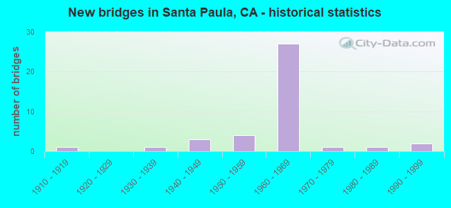
- New bridges - historical statistics
- 11910-1919
- 11930-1939
- 31940-1949
- 41950-1959
- 271960-1969
- 11970-1979
- 11980-1989
- 21990-1999
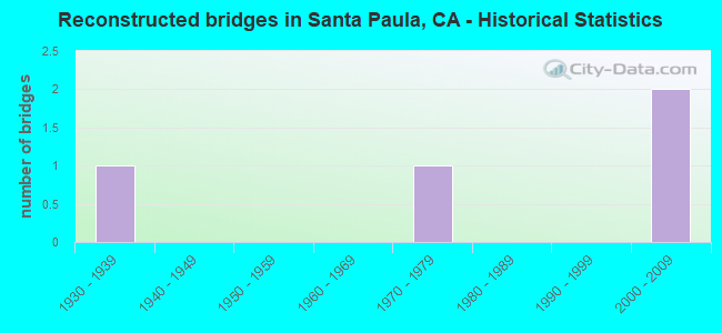
- Reconstructed bridges - Historical Statistics
- 11930-1939
- 01940-1949
- 01950-1959
- 01960-1969
- 11970-1979
- 01980-1989
- 01990-1999
- 22000-2009
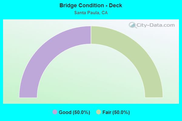
- Bridge Condition - Deck
- 50.0%Good
- 50.0%Fair
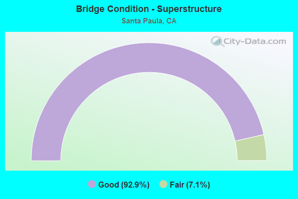
- Bridge Condition - Superstructure
- 92.9%Good
- 7.1%Fair
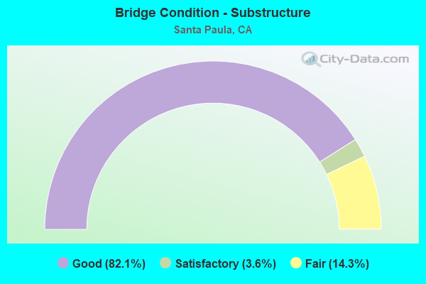
- Bridge Condition - Substructure
- 82.1%Good
- 3.6%Satisfactory
- 14.3%Fair
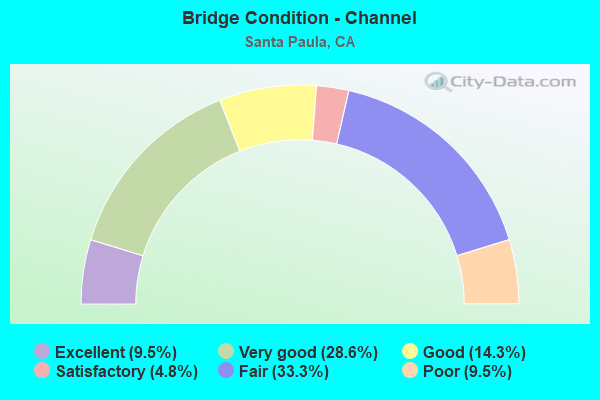
- Bridge Condition - Channel
- 9.5%Excellent
- 28.6%Very good
- 14.3%Good
- 4.8%Satisfactory
- 33.3%Fair
- 9.5%Poor
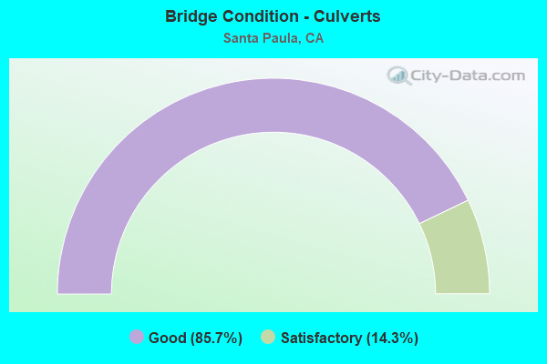
- Bridge Condition - Culverts
- 85.7%Good
- 14.3%Satisfactory
Find on map >> Show street view
Structure Number: 52 0029, Location: 07-VEN-126-R13.57 (Lat: 34.363622, Lng: -119.037994), Route carried "on" structure: State highway 126, Year Built: 1985, Status: Open, Structure Length: 2.90m (9.51ft), Average Daily Traffic: 32,000 (year 2009), Truck Traffic: 11%, Average Future Daily Traffic: 66,240 (year 2041), Design Load: HS 20+Mod, Features Intersected: HAUN CREEK
Minimum Vertical Clearance: 30+ m (98+ ft), Kilometerpoint: 13.570, Lanes on structure: 5, Base Highway Network: Yes (Inventory Route: 1, Subroute: 1), Owner: State Highway Agency, Approaching Roadway Width: 23.2m (76.1ft), Skew: 4 degrees, Material/Design: Prestressed concrete, Design/Construction: Slab, Number Of Spans In Main Unit: 2, Length of Maximum Span: 13.8m (45.3ft), Curb-To-Curb Width: 23.2m (76.1ft), Out-to-Out Width: 24.0m (78.7ft)
Condition: Deck: Good, Superstructure: Good, Substructure: Good, Channel: Good, Operating Rating: 54.0 metric tons, Method Used To Determine Operating Rating: Field evaluation and documented engineering judgment, Inventory Rating: 32.4 metric tons, Method Used To Determine Inventory Rating: Field evaluation and documented engineering judgment, Structural Evaluation: Better than present minimum criteria, Deck Geometry: Better than present minimum criteria, Waterway Adequacy: Equal to present desirable criteria, Approach Roadway Alignment: Somewhat better than minimum adequacy, Designated Inspection Frequency: Every 48 months, Inspection Date: August 2019, Deck Structure Type: Concrete Cast-file-Place
Find on map >> Show street view
Structure Number: 52 0103, Location: 07-VEN-150-28.48 (Lat: 34.427475, Lng: -119.091892), Route carried "on" structure: State highway 150, Year Built: 1958, Year Reconstructed: 2009, Status: Open, Structure Length: 1.93m (6.33ft), Average Daily Traffic: 3,150 (year 2020), Truck Traffic: 6%, Average Future Daily Traffic: 3,600 (year 2041), Design Load: HS 20, Features Intersected: SISAR CREEK
Minimum Vertical Clearance: 30+ m (98+ ft), Kilometerpoint: 28.480, Lanes on structure: 2, Base Highway Network: Yes (Inventory Route: 1, Subroute: 3), Owner: State Highway Agency, Approaching Roadway Width: 12.0m (39.4ft), Skew: 3 degrees, Material/Design: Concrete, Design/Construction: Box Beam or Girders - Multiple, Number Of Spans In Main Unit: 1, Length of Maximum Span: 18.1m (59.4ft), Curb or Sidewalk Widths: Left: 0.6m (2.0ft), Right: 0.6m (2.0ft), Curb-To-Curb Width: 12.0m (39.4ft), Out-to-Out Width: 13.1m (43.0ft)
Condition: Deck: Good, Superstructure: Good, Substructure: Good, Channel: Fair, Operating Rating: 94.6 metric tons, Method Used To Determine Operating Rating: Load Factor (LF), Inventory Rating: 57.0 metric tons, Method Used To Determine Inventory Rating: Load Factor (LF), Structural Evaluation: Better than present minimum criteria, Deck Geometry: Somewhat better than minimum adequacy, Waterway Adequacy: Equal to present desirable criteria, Approach Roadway Alignment: Equal to present desirable criteria, Designated Inspection Frequency: Every 24 months, Inspection Date: September 2021, Deck Structure Type: Concrete Cast-file-Place, Wearing Surface/Protective System: Wearing Surface: Monolithic Concrete
Find on map >> Show street view
Structure Number: 52 0104, Location: 07-VEN-150-28.53 (Lat: 34.427381, Lng: -119.091008), Route carried "on" structure: State highway 150, Year Built: 1958, Year Reconstructed: 2009, Status: Open, Structure Length: 2.25m (7.38ft), Average Daily Traffic: 3,250 (year 2009), Truck Traffic: 3%, Average Future Daily Traffic: 4,682 (year 2041), Design Load: HS 20, Features Intersected: SANTA PAULA CREEK
Minimum Vertical Clearance: 30+ m (98+ ft), Kilometerpoint: 28.530, Lanes on structure: 2, Base Highway Network: Yes (Inventory Route: 1, Subroute: 3), Owner: State Highway Agency, Approaching Roadway Width: 12.2m (40.0ft), Skew: 3 degrees, Material/Design: Concrete, Design/Construction: Box Beam or Girders - Multiple, Number Of Spans In Main Unit: 1, Length of Maximum Span: 21.2m (69.6ft), Curb-To-Curb Width: 12.2m (40.0ft), Out-to-Out Width: 13.2m (43.3ft)
Condition: Deck: Good, Superstructure: Good, Substructure: Good, Channel: Good, Operating Rating: 92.7 metric tons, Method Used To Determine Operating Rating: Load Factor (LF), Inventory Rating: 55.7 metric tons, Method Used To Determine Inventory Rating: Load Factor (LF), Structural Evaluation: Better than present minimum criteria, Deck Geometry: Equal to present minimum criteria, Waterway Adequacy: Equal to present desirable criteria, Approach Roadway Alignment: Equal to present desirable criteria, Designated Inspection Frequency: Every 48 months, Inspection Date: September 2019, Deck Structure Type: Concrete Cast-file-Place
Find on map >> Show street view
Structure Number: 52 0105, Location: 07-VEN-150-28.61 (Lat: 34.426739, Lng: -119.089942), Route carried "on" structure: State highway 150, Year Built: 1969, Status: Open, Structure Length: 5.44m (17.85ft), Average Daily Traffic: 3,150 (year 2020), Truck Traffic: 6%, Average Future Daily Traffic: 3,600 (year 2041), Design Load: HS 20, Features Intersected: SANTA PAULA CREEK
Minimum Vertical Clearance: 30+ m (98+ ft), Kilometerpoint: 28.610, Lanes on structure: 2, Base Highway Network: Yes (Inventory Route: 1, Subroute: 3), Owner: State Highway Agency, Approaching Roadway Width: 9.8m (32.2ft), Skew: 5 degrees, Material/Design: Prestressed concrete, Design/Construction: Box Beam or Girders - Multiple, Number Of Spans In Main Unit: 1, Length of Maximum Span: 54.0m (177.2ft), Curb-To-Curb Width: 9.8m (32.2ft), Out-to-Out Width: 10.4m (34.1ft)
Condition: Deck: Good, Superstructure: Good, Substructure: Good, Channel: Good, Operating Rating: 97.2 metric tons, Method Used To Determine Operating Rating: Load Factor (LF), Inventory Rating: 32.4 metric tons, Method Used To Determine Inventory Rating: Load Factor (LF), Structural Evaluation: Better than present minimum criteria, Deck Geometry: Meets minimum limits, Waterway Adequacy: Equal to present desirable criteria, Approach Roadway Alignment: Equal to present desirable criteria, Designated Inspection Frequency: Every 24 months, Inspection Date: September 2021, Deck Structure Type: Concrete Cast-file-Place
Find on map >> Show street view
Structure Number: 52 0250L, Location: 07-VEN-126-R7.81 (Lat: 34.313144, Lng: -119.116936), Route carried "on" structure: State highway 126, Year Built: 1965, Status: Open, Structure Length: 5.03m (16.50ft), Average Daily Traffic: 25,000 (year 2019), Truck Traffic: 10%, Average Future Daily Traffic: 34,370 (year 2041), Design Load: HS 20, Features Intersected: TODD BARRANCA
Minimum Vertical Clearance: 30+ m (98+ ft), Kilometerpoint: 7.810, Lanes on structure: 2, Lanes under structure: 2, Base Highway Network: Yes (Inventory Route: 1, Subroute: 1), Owner: State Highway Agency, Approaching Roadway Width: 11.3m (37.1ft), Material/Design: Concrete continuous, Design/Construction: Tee Beam, Number Of Spans In Main Unit: 4, Length of Maximum Span: 16.0m (52.5ft), Curb-To-Curb Width: 11.3m (37.1ft), Out-to-Out Width: 12.1m (39.7ft)
Condition: Deck: Fair, Superstructure: Good, Substructure: Good, Channel: Poor, Operating Rating: 42.1 metric tons, Method Used To Determine Operating Rating: Load and Resistance Factor Rating (LRFR) rating reported by rating factor(RF) method using HL-93 loadings, Inventory Rating: 32.7 metric tons, Method Used To Determine Inventory Rating: Load and Resistance Factor Rating (LRFR) rating reported by rating factor(RF) method using HL-93 loadings, Structural Evaluation: Better than present minimum criteria, Deck Geometry: Equal to present minimum criteria, Underclear: Meets minimum limits, Waterway Adequacy: Equal to present desirable criteria, Approach Roadway Alignment: Superior to present desirable criteria, Designated Inspection Frequency: Every 24 months, Inspection Date: July 2021, Deck Structure Type: Concrete Cast-file-Place
Find on map >> Show street view
Structure Number: 52 0250R, Location: 07-VEN-126-R7.81 (Lat: 34.312986, Lng: -119.116775), Route carried "on" structure: State highway 126, Year Built: 1965, Status: Open, Structure Length: 5.03m (16.50ft), Average Daily Traffic: 25,000 (year 2019), Truck Traffic: 10%, Average Future Daily Traffic: 34,370 (year 2041), Design Load: HS 20, Features Intersected: TODD BARRANCA
Minimum Vertical Clearance: 30+ m (98+ ft), Kilometerpoint: 7.810, Lanes on structure: 2, Lanes under structure: 2, Base Highway Network: Yes (Inventory Route: 1, Subroute: 1), Owner: State Highway Agency, Approaching Roadway Width: 11.3m (37.1ft), Material/Design: Concrete continuous, Design/Construction: Tee Beam, Number Of Spans In Main Unit: 4, Length of Maximum Span: 16.0m (52.5ft), Curb-To-Curb Width: 11.3m (37.1ft), Out-to-Out Width: 12.1m (39.7ft)
Condition: Deck: Fair, Superstructure: Good, Substructure: Fair, Channel: Poor, Operating Rating: 49.6 metric tons, Method Used To Determine Operating Rating: Load and Resistance Factor Rating (LRFR) rating reported by rating factor(RF) method using HL-93 loadings, Inventory Rating: 35.3 metric tons, Method Used To Determine Inventory Rating: Load and Resistance Factor Rating (LRFR) rating reported by rating factor(RF) method using HL-93 loadings, Structural Evaluation: Somewhat better than minimum adequacy, Deck Geometry: Equal to present minimum criteria, Underclear: Meets minimum limits, Waterway Adequacy: Equal to present desirable criteria, Approach Roadway Alignment: Superior to present desirable criteria, Designated Inspection Frequency: Every 24 months, Inspection Date: July 2021, Deck Structure Type: Concrete Cast-file-Place
Find on map >> Show street view
Structure Number: 52 0251, Location: 07-VEN-126-R7.95 (Lat: 34.314181, Lng: -119.114772), Route carried "on" structure: State highway 126, Year Built: 1965, Status: Open, Structure Length: 6.27m (20.57ft), Average Daily Traffic: 48,000 (year 2009), Truck Traffic: 10%, Average Future Daily Traffic: 82,372 (year 2041), Design Load: HS 20, Features Intersected: VCY RY
Minimum Vertical Clearance: 30+ m (98+ ft), Kilometerpoint: 7.950, Lanes on structure: 4, Base Highway Network: Yes (Inventory Route: 1, Subroute: 1), Owner: State Highway Agency, Approaching Roadway Width: 33.5m (109.9ft), Skew: 37 degrees, Material/Design: Concrete, Design/Construction: Box Beam or Girders - Multiple, Number Of Spans In Main Unit: 1, Length of Maximum Span: 13.6m (44.6ft), Curb-To-Curb Width: 33.5m (109.9ft), Out-to-Out Width: 40.5m (132.9ft)
Condition: Deck: Good, Superstructure: Good, Substructure: Good, Operating Rating: 63.5 metric tons, Method Used To Determine Operating Rating: Load Factor (LF), Inventory Rating: 38.2 metric tons, Method Used To Determine Inventory Rating: Load Factor (LF), Structural Evaluation: Better than present minimum criteria, Deck Geometry: Superior to present desirable criteria, Underclear: Better than present minimum criteria, Approach Roadway Alignment: Superior to present desirable criteria, Designated Inspection Frequency: Every 48 months, Inspection Date: July 2019, Deck Structure Type: Concrete Cast-file-Place
Find on map >> Show street view
Structure Number: 52 0252, Location: 07-VEN-126-R8.91 (Lat: 34.322728, Lng: -119.101489), Route carried "on" structure: County highway , Year Built: 1965, Status: Open, Structure Length: 7.92m (25.98ft), Average Daily Traffic: 1,400 (year 2011), Truck Traffic: 1%, Average Future Daily Traffic: 1,614 (year 2041), Design Load: HS 20, Features Intersected: ROUTE 126, Facility Carried by Structure: BRIGGS ROAD
Minimum Vertical Clearance: 30+ m (98+ ft), Kilometerpoint: 0.000, Lanes on structure: 2, Lanes under structure: 6, Owner: State Highway Agency, Approaching Roadway Width: 9.7m (31.8ft), Material/Design: Concrete continuous, Design/Construction: Box Beam or Girders - Multiple, Number Of Spans In Main Unit: 4, Length of Maximum Span: 25.0m (82.0ft), Curb or Sidewalk Widths: Left: 0.0m, Right: 1.5m (4.9ft), Curb-To-Curb Width: 9.7m (31.8ft), Out-to-Out Width: 12.3m (40.4ft)
Condition: Deck: Fair, Superstructure: Good, Substructure: Good, Operating Rating: 33.4 metric tons, Method Used To Determine Operating Rating: Load and Resistance Factor Rating (LRFR) rating reported by rating factor(RF) method using HL-93 loadings, Inventory Rating: 25.6 metric tons, Method Used To Determine Inventory Rating: Load and Resistance Factor Rating (LRFR) rating reported by rating factor(RF) method using HL-93 loadings, Structural Evaluation: Equal to present minimum criteria, Deck Geometry: Somewhat better than minimum adequacy, Underclear: Meets minimum limits, Approach Roadway Alignment: Superior to present desirable criteria, Designated Inspection Frequency: Every 24 months, Inspection Date: July 2021, Deck Structure Type: Concrete Cast-file-Place
Find on map >> Show street view
Structure Number: 52 0254, Location: 07-VEN-126-R10.04 (Lat: 34.333667, Lng: -119.087150), Route carried "on" structure: State highway 126, Year Built: 1965, Status: Open, Structure Length: 0.67m (2.20ft), Average Daily Traffic: 51,000 (year 2019), Truck Traffic: 10%, Average Future Daily Traffic: 85,833 (year 2041), Design Load: HS 20, Features Intersected: TODD LANE
Minimum Vertical Clearance: 30+ m (98+ ft), Kilometerpoint: 10.040, Lanes on structure: 4, Lanes under structure: 2, Base Highway Network: Yes (Inventory Route: 1, Subroute: 1), Owner: State Highway Agency, Approaching Roadway Width: 33.5m (109.9ft), Skew: 31 degrees, Material/Design: Concrete, Design/Construction: Frame, Number Of Spans In Main Unit: 1, Length of Maximum Span: 6.1m (20.0ft)
Condition: Deck: Good, Superstructure: Good, Substructure: Fair, Operating Rating: 79.7 metric tons, Method Used To Determine Operating Rating: Load Factor (LF), Inventory Rating: 48.0 metric tons, Method Used To Determine Inventory Rating: Load Factor (LF), Structural Evaluation: Somewhat better than minimum adequacy, Underclear: High priority of corrective action, Approach Roadway Alignment: Superior to present desirable criteria, Designated Inspection Frequency: Every 24 months, Inspection Date: August 2021
Find on map >> Show street view
Structure Number: 52 0257L, Location: 07-VEN-126-R11.37-SPA (Lat: 34.345444, Lng: -119.068769), Route carried "on" structure: State highway 126, Year Built: 1965, Status: Open, Structure Length: 3.66m (12.01ft), Average Daily Traffic: 23,500 (year 2019), Truck Traffic: 10%, Average Future Daily Traffic: 72,902 (year 2041), Design Load: HS 20, Features Intersected: PALM AVENUE
Minimum Vertical Clearance: 30+ m (98+ ft), Kilometerpoint: 11.370, Lanes on structure: 2, Lanes under structure: 2, Base Highway Network: Yes (Inventory Route: 1, Subroute: 1), Owner: State Highway Agency, Approaching Roadway Width: 11.3m (37.1ft), Material/Design: Concrete continuous, Design/Construction: Tee Beam, Number Of Spans In Main Unit: 3, Length of Maximum Span: 18.3m (60.0ft), Curb-To-Curb Width: 11.3m (37.1ft), Out-to-Out Width: 12.1m (39.7ft)
Condition: Deck: Fair, Superstructure: Good, Substructure: Good, Operating Rating: 63.2 metric tons, Method Used To Determine Operating Rating: Load Factor (LF), Inventory Rating: 38.2 metric tons, Method Used To Determine Inventory Rating: Load Factor (LF), Structural Evaluation: Better than present minimum criteria, Deck Geometry: Somewhat better than minimum adequacy, Underclear: Somewhat better than minimum adequacy, Approach Roadway Alignment: Superior to present desirable criteria, Designated Inspection Frequency: Every 24 months, Inspection Date: August 2021, Deck Structure Type: Concrete Cast-file-Place
Find on map >> Show street view
Structure Number: 52 0257R, Location: 07-VEN-126-R11.37-SPA (Lat: 34.345286, Lng: -119.068619), Route carried "on" structure: State highway 126, Year Built: 1965, Status: Open, Structure Length: 3.66m (12.01ft), Average Daily Traffic: 23,500 (year 2019), Truck Traffic: 10%, Average Future Daily Traffic: 26,415 (year 2041), Design Load: HS 20, Features Intersected: PALM AVENUE
Minimum Vertical Clearance: 30+ m (98+ ft), Kilometerpoint: 11.370, Lanes on structure: 2, Lanes under structure: 2, Base Highway Network: Yes (Inventory Route: 1, Subroute: 1), Owner: State Highway Agency, Approaching Roadway Width: 11.3m (37.1ft), Material/Design: Concrete continuous, Design/Construction: Tee Beam, Number Of Spans In Main Unit: 3, Length of Maximum Span: 18.3m (60.0ft), Curb-To-Curb Width: 11.3m (37.1ft), Out-to-Out Width: 12.1m (39.7ft)
Condition: Deck: Fair, Superstructure: Good, Substructure: Good, Operating Rating: 63.2 metric tons, Method Used To Determine Operating Rating: Load Factor (LF), Inventory Rating: 38.2 metric tons, Method Used To Determine Inventory Rating: Load Factor (LF), Structural Evaluation: Better than present minimum criteria, Deck Geometry: Somewhat better than minimum adequacy, Underclear: Somewhat better than minimum adequacy, Approach Roadway Alignment: Superior to present desirable criteria, Designated Inspection Frequency: Every 24 months, Inspection Date: August 2021, Deck Structure Type: Concrete Cast-file-Place
Find on map >> Show street view
Structure Number: 52 0259L, Location: 07-VEN-126-R11.79-SPA (Lat: 34.348894, Lng: -119.062586), Route carried "on" structure: State highway 126, Year Built: 1965, Status: Open, Structure Length: 3.66m (12.01ft), Average Daily Traffic: 23,500 (year 2019), Truck Traffic: 10%, Average Future Daily Traffic: 25,893 (year 2039), Design Load: HS 20, Features Intersected: EIGHTH STREET
Minimum Vertical Clearance: 30+ m (98+ ft), Kilometerpoint: 11.790, Lanes on structure: 2, Lanes under structure: 2, Base Highway Network: Yes (Inventory Route: 1, Subroute: 1), Owner: State Highway Agency, Approaching Roadway Width: 11.3m (37.1ft), Material/Design: Concrete continuous, Design/Construction: Tee Beam, Number Of Spans In Main Unit: 3, Length of Maximum Span: 18.3m (60.0ft), Curb or Sidewalk Widths: Left: 0.0m, Right: 0.6m (2.0ft), Curb-To-Curb Width: 11.3m (37.1ft), Out-to-Out Width: 12.7m (41.7ft)
Condition: Deck: Fair, Superstructure: Good, Substructure: Good, Operating Rating: 32.1 metric tons, Method Used To Determine Operating Rating: Load and Resistance Factor Rating (LRFR) rating reported by rating factor(RF) method using HL-93 loadings, Inventory Rating: 24.6 metric tons, Method Used To Determine Inventory Rating: Load and Resistance Factor Rating (LRFR) rating reported by rating factor(RF) method using HL-93 loadings, Structural Evaluation: Equal to present minimum criteria, Deck Geometry: Somewhat better than minimum adequacy, Underclear: Somewhat better than minimum adequacy, Approach Roadway Alignment: Equal to present desirable criteria, Designated Inspection Frequency: Every 24 months, Inspection Date: August 2021, Deck Structure Type: Concrete Cast-file-Place
Find on map >> Show street view
Structure Number: 52 0259R, Location: 07-VEN-126-R11.79-SPA (Lat: 34.348714, Lng: -119.062475), Route carried "on" structure: State highway 126, Year Built: 1965, Status: Open, Structure Length: 3.66m (12.01ft), Average Daily Traffic: 23,500 (year 2019), Truck Traffic: 10%, Average Future Daily Traffic: 25,893 (year 2039), Design Load: HS 20, Features Intersected: EIGHTH STREET
Minimum Vertical Clearance: 30+ m (98+ ft), Kilometerpoint: 11.790, Lanes on structure: 2, Lanes under structure: 2, Base Highway Network: Yes (Inventory Route: 1, Subroute: 1), Owner: State Highway Agency, Approaching Roadway Width: 11.3m (37.1ft), Material/Design: Concrete continuous, Design/Construction: Tee Beam, Number Of Spans In Main Unit: 3, Length of Maximum Span: 18.3m (60.0ft), Curb-To-Curb Width: 11.3m (37.1ft), Out-to-Out Width: 12.1m (39.7ft)
Condition: Deck: Fair, Superstructure: Good, Substructure: Good, Operating Rating: 32.1 metric tons, Method Used To Determine Operating Rating: Load and Resistance Factor Rating (LRFR) rating reported by rating factor(RF) method using HL-93 loadings, Inventory Rating: 24.6 metric tons, Method Used To Determine Inventory Rating: Load and Resistance Factor Rating (LRFR) rating reported by rating factor(RF) method using HL-93 loadings, Structural Evaluation: Equal to present minimum criteria, Deck Geometry: Somewhat better than minimum adequacy, Underclear: Somewhat better than minimum adequacy, Approach Roadway Alignment: Equal to present desirable criteria, Designated Inspection Frequency: Every 24 months, Inspection Date: August 2021, Deck Structure Type: Concrete Cast-file-Place
Find on map >> Show street view
Structure Number: 52 0260R, Location: 07-VEN-126-R12.04-SPA (Lat: 34.349867, Lng: -119.058339), Route carried "on" structure: State highway 126, Year Built: 1965, Status: Open, Structure Length: 3.66m (12.01ft), Average Daily Traffic: 18,750 (year 2018), Truck Traffic: 10%, Average Future Daily Traffic: 25,893 (year 2039), Design Load: HS 20, Features Intersected: ROUTE 150 (10TH ST)
Minimum Vertical Clearance: 30+ m (98+ ft), Kilometerpoint: 12.040, Lanes on structure: 2, Lanes under structure: 2, Base Highway Network: Yes (Inventory Route: 1, Subroute: 1), Owner: State Highway Agency, Approaching Roadway Width: 11.3m (37.1ft), Material/Design: Concrete continuous, Design/Construction: Tee Beam, Number Of Spans In Main Unit: 3, Length of Maximum Span: 18.3m (60.0ft), Curb-To-Curb Width: 11.3m (37.1ft), Out-to-Out Width: 12.1m (39.7ft)
Condition: Deck: Fair, Superstructure: Good, Substructure: Good, Operating Rating: 32.4 metric tons, Method Used To Determine Operating Rating: Load and Resistance Factor Rating (LRFR) rating reported by rating factor(RF) method using HL-93 loadings, Inventory Rating: 24.9 metric tons, Method Used To Determine Inventory Rating: Load and Resistance Factor Rating (LRFR) rating reported by rating factor(RF) method using HL-93 loadings, Structural Evaluation: Equal to present minimum criteria, Deck Geometry: Somewhat better than minimum adequacy, Underclear: Meets minimum limits, Approach Roadway Alignment: Equal to present desirable criteria, Designated Inspection Frequency: Every 24 months, Inspection Date: August 2021, Deck Structure Type: Concrete Cast-file-Place
Find on map >> Show street view
Structure Number: 52 0261L, Location: 07-VEN-126-R12.29-SPA (Lat: 34.351467, Lng: -119.054386), Route carried "on" structure: State highway 126, Year Built: 1965, Status: Open, Structure Length: 3.66m (12.01ft), Average Daily Traffic: 18,250 (year 2019), Truck Traffic: 12%, Average Future Daily Traffic: 24,733 (year 2039), Design Load: HS 20, Features Intersected: TWELFTH STREET
Minimum Vertical Clearance: 30+ m (98+ ft), Kilometerpoint: 12.290, Lanes on structure: 2, Lanes under structure: 2, Base Highway Network: Yes (Inventory Route: 1, Subroute: 1), Owner: State Highway Agency, Approaching Roadway Width: 11.3m (37.1ft), Material/Design: Concrete continuous, Design/Construction: Tee Beam, Number Of Spans In Main Unit: 3, Length of Maximum Span: 18.3m (60.0ft), Curb-To-Curb Width: 11.3m (37.1ft), Out-to-Out Width: 12.1m (39.7ft)
Condition: Deck: Fair, Superstructure: Good, Substructure: Good, Operating Rating: 64.8 metric tons, Method Used To Determine Operating Rating: Load Factor (LF), Inventory Rating: 39.2 metric tons, Method Used To Determine Inventory Rating: Load Factor (LF), Structural Evaluation: Better than present minimum criteria, Deck Geometry: Somewhat better than minimum adequacy, Underclear: Somewhat better than minimum adequacy, Approach Roadway Alignment: Equal to present desirable criteria, Designated Inspection Frequency: Every 24 months, Inspection Date: August 2021, Deck Structure Type: Concrete Cast-file-Place
Find on map >> Show street view
Structure Number: 52 0261R, Location: 07-VEN-126-R12.29-SPA (Lat: 34.351267, Lng: -119.054317), Route carried "on" structure: State highway 126, Year Built: 1965, Status: Open, Structure Length: 3.96m (12.99ft), Average Daily Traffic: 18,250 (year 2019), Truck Traffic: 12%, Average Future Daily Traffic: 67,452 (year 2039), Design Load: HS 20, Features Intersected: TWELFTH STREET
Minimum Vertical Clearance: 30+ m (98+ ft), Kilometerpoint: 12.290, Lanes on structure: 2, Lanes under structure: 2, Base Highway Network: Yes (Inventory Route: 1, Subroute: 1), Owner: State Highway Agency, Approaching Roadway Width: 11.3m (37.1ft), Material/Design: Concrete continuous, Design/Construction: Tee Beam, Number Of Spans In Main Unit: 3, Length of Maximum Span: 18.3m (60.0ft), Curb or Sidewalk Widths: Left: 0.0m, Right: 0.6m (2.0ft), Curb-To-Curb Width: 11.3m (37.1ft), Out-to-Out Width: 12.6m (41.3ft)
Condition: Deck: Fair, Superstructure: Good, Substructure: Good, Operating Rating: 42.4 metric tons, Method Used To Determine Operating Rating: Load Factor (LF), Inventory Rating: 25.6 metric tons, Method Used To Determine Inventory Rating: Load Factor (LF), Structural Evaluation: Equal to present minimum criteria, Deck Geometry: Somewhat better than minimum adequacy, Underclear: Somewhat better than minimum adequacy, Approach Roadway Alignment: Equal to present desirable criteria, Designated Inspection Frequency: Every 24 months, Inspection Date: August 2021, Deck Structure Type: Concrete Cast-file-Place
Find on map >> Show street view
Structure Number: 52 0262, Location: 07-VEN-126-R9.65 (Lat: 34.329481, Lng: -119.091672), Route carried "on" structure: State highway 126, Year Built: 1965, Status: Open, Structure Length: 0.79m (2.59ft), Average Daily Traffic: 47,000 (year 2009), Average Future Daily Traffic: 85,833 (year 2041), Design Load: HS 20, Features Intersected: ADAMS BARRANCA
Minimum Vertical Clearance: 30+ m (98+ ft), Kilometerpoint: 9.650, Lanes on structure: 4, Base Highway Network: Yes (Inventory Route: 1, Subroute: 1), Owner: State Highway Agency, Approaching Roadway Width: 33.5m (109.9ft), Skew: 20 degrees, Material/Design: Concrete continuous, Design/Construction: Culvert, Number Of Spans In Main Unit: 2, Length of Maximum Span: 4.0m (13.1ft), Curb-To-Curb Width: 33.5m (109.9ft), Out-to-Out Width: 55.8m (183.1ft)
Condition: Channel: Very good, Culverts: Good, Operating Rating: 54.1 metric tons, Method Used To Determine Operating Rating: Field evaluation and documented engineering judgment, Inventory Rating: 32.4 metric tons, Method Used To Determine Inventory Rating: Field evaluation and documented engineering judgment, Structural Evaluation: Better than present minimum criteria, Deck Geometry: Superior to present desirable criteria, Waterway Adequacy: Equal to present desirable criteria, Approach Roadway Alignment: Superior to present desirable criteria, Designated Inspection Frequency: Every 48 months, Inspection Date: July 2019
Find on map >> Show street view
Structure Number: 52 0265, Location: 07-VEN-126-R10.38-SPA (Lat: 34.337436, Lng: -119.083083), Route carried "on" structure: City street Z607, Year Built: 1965, Status: Open, Structure Length: 7.35m (24.11ft), Average Daily Traffic: 10,000 (year 2018), Truck Traffic: 1%, Average Future Daily Traffic: 11,601 (year 2039), Design Load: HS 20, Features Intersected: ROUTE 126, Facility Carried by Structure: PECK ROAD
Minimum Vertical Clearance: 30+ m (98+ ft), Kilometerpoint: 0.000, Lanes on structure: 2, Lanes under structure: 6, Owner: State Highway Agency, Approaching Roadway Width: 9.8m (32.2ft), Material/Design: Concrete continuous, Design/Construction: Box Beam or Girders - Multiple, Number Of Spans In Main Unit: 4, Length of Maximum Span: 26.5m (86.9ft), Curb or Sidewalk Widths: Left: 0.0m, Right: 1.5m (4.9ft), Curb-To-Curb Width: 9.8m (32.2ft), Out-to-Out Width: 12.3m (40.4ft)
Condition: Deck: Fair, Superstructure: Good, Substructure: Good, Operating Rating: 35.0 metric tons, Method Used To Determine Operating Rating: Load and Resistance Factor Rating (LRFR) rating reported by rating factor(RF) method using HL-93 loadings, Inventory Rating: 26.9 metric tons, Method Used To Determine Inventory Rating: Load and Resistance Factor Rating (LRFR) rating reported by rating factor(RF) method using HL-93 loadings, Structural Evaluation: Equal to present minimum criteria, Deck Geometry: Meets minimum limits, Underclear: High priority of corrective action, Approach Roadway Alignment: Superior to present desirable criteria, Designated Inspection Frequency: Every 24 months, Inspection Date: August 2021, Deck Structure Type: Concrete Cast-file-Place
Find on map >> Show street view
Structure Number: 52 0267L, Location: 07-VEN-126-R12.71-SPA (Lat: 34.354972, Lng: -119.048564), Route carried "on" structure: State highway 126, Year Built: 1965, Status: Open, Structure Length: 5.30m (17.39ft), Average Daily Traffic: 18,250 (year 2019), Truck Traffic: 12%, Average Future Daily Traffic: 68,812 (year 2041), Design Load: HS 20, Features Intersected: SANTA PAULA CREEK
Minimum Vertical Clearance: 30+ m (98+ ft), Kilometerpoint: 12.710, Lanes on structure: 2, Base Highway Network: Yes (Inventory Route: 1, Subroute: 1), Owner: State Highway Agency, Approaching Roadway Width: 11.3m (37.1ft), Skew: 3 degrees, Material/Design: Concrete continuous, Design/Construction: Tee Beam, Number Of Spans In Main Unit: 3, Length of Maximum Span: 21.3m (69.9ft), Curb-To-Curb Width: 11.3m (37.1ft), Out-to-Out Width: 12.1m (39.7ft)
Condition: Deck: Fair, Superstructure: Good, Substructure: Fair, Channel: Fair, Operating Rating: 43.4 metric tons, Method Used To Determine Operating Rating: Load and Resistance Factor Rating (LRFR) rating reported by rating factor(RF) method using HL-93 loadings, Inventory Rating: 33.4 metric tons, Method Used To Determine Inventory Rating: Load and Resistance Factor Rating (LRFR) rating reported by rating factor(RF) method using HL-93 loadings, Structural Evaluation: Somewhat better than minimum adequacy, Deck Geometry: Somewhat better than minimum adequacy, Waterway Adequacy: Equal to present desirable criteria, Approach Roadway Alignment: Superior to present desirable criteria, Designated Inspection Frequency: Every 24 months, Inspection Date: August 2021, Deck Structure Type: Concrete Cast-file-Place
Find on map >> Show street view
Structure Number: 52 0267R, Location: 07-VEN-126-R12.70-SPA (Lat: 34.354769, Lng: -119.048478), Route carried "on" structure: State highway 126, Year Built: 1965, Status: Open, Structure Length: 5.30m (17.39ft), Average Daily Traffic: 18,250 (year 2019), Truck Traffic: 12%, Average Future Daily Traffic: 68,812 (year 2041), Design Load: HS 20, Features Intersected: SANTA PAULA CREEK
Minimum Vertical Clearance: 30+ m (98+ ft), Kilometerpoint: 12.700, Lanes on structure: 2, Base Highway Network: Yes (Inventory Route: 1, Subroute: 1), Owner: State Highway Agency, Approaching Roadway Width: 11.3m (37.1ft), Skew: 3 degrees, Material/Design: Concrete continuous, Design/Construction: Tee Beam, Number Of Spans In Main Unit: 3, Length of Maximum Span: 21.3m (69.9ft), Curb-To-Curb Width: 11.3m (37.1ft), Out-to-Out Width: 12.1m (39.7ft)
Condition: Deck: Fair, Superstructure: Good, Substructure: Good, Channel: Fair, Operating Rating: 43.4 metric tons, Method Used To Determine Operating Rating: Load and Resistance Factor Rating (LRFR) rating reported by rating factor(RF) method using HL-93 loadings, Inventory Rating: 33.4 metric tons, Method Used To Determine Inventory Rating: Load and Resistance Factor Rating (LRFR) rating reported by rating factor(RF) method using HL-93 loadings, Structural Evaluation: Better than present minimum criteria, Deck Geometry: Somewhat better than minimum adequacy, Waterway Adequacy: Equal to present desirable criteria, Approach Roadway Alignment: Superior to present desirable criteria, Designated Inspection Frequency: Every 24 months, Inspection Date: August 2021, Deck Structure Type: Concrete Cast-file-Place
Find on map >> Show street view
Structure Number: 52 0291, Location: 07-VEN-126-R8.52 (Lat: 34.318969, Lng: -119.106742), Route carried "on" structure: State highway 126, Year Built: 1965, Status: Open, Structure Length: 0.79m (2.59ft), Average Daily Traffic: 48,000 (year 2009), Truck Traffic: 10%, Average Future Daily Traffic: 82,372 (year 2041), Design Load: HS 20, Features Intersected: OUTLAND BARRANCA
Minimum Vertical Clearance: 30+ m (98+ ft), Kilometerpoint: 8.520, Lanes on structure: 4, Base Highway Network: Yes (Inventory Route: 1, Subroute: 1), Owner: State Highway Agency, Approaching Roadway Width: 33.5m (109.9ft), Skew: 20 degrees, Material/Design: Concrete continuous, Design/Construction: Culvert, Number Of Spans In Main Unit: 3, Length of Maximum Span: 2.4m (7.9ft), Curb-To-Curb Width: 33.5m (109.9ft), Out-to-Out Width: 54.6m (179.1ft)
Condition: Channel: Very good, Culverts: Good, Operating Rating: 54.1 metric tons, Method Used To Determine Operating Rating: Field evaluation and documented engineering judgment, Inventory Rating: 32.4 metric tons, Method Used To Determine Inventory Rating: Field evaluation and documented engineering judgment, Structural Evaluation: Better than present minimum criteria, Deck Geometry: Superior to present desirable criteria, Waterway Adequacy: Equal to present desirable criteria, Approach Roadway Alignment: Superior to present desirable criteria, Designated Inspection Frequency: Every 48 months, Inspection Date: July 2019
Find on map >> Show street view
Structure Number: 52 0292, Location: 07-VEN-126-R10.40-SPA (Lat: 34.337161, Lng: -119.082542), Route carried "on" structure: State highway 126, Year Built: 1965, Status: Open, Structure Length: 0.79m (2.59ft), Average Daily Traffic: 37,500 (year 2006), Truck Traffic: 10%, Average Future Daily Traffic: 52,829 (year 2041), Design Load: HS 20, Features Intersected: FARMERS IRRIGATION CHA
Minimum Vertical Clearance: 30+ m (98+ ft), Kilometerpoint: 10.400, Lanes on structure: 6, Base Highway Network: Yes (Inventory Route: 1, Subroute: 1), Owner: State Highway Agency, Approaching Roadway Width: 45.7m (149.9ft), Skew: 30 degrees, Material/Design: Concrete continuous, Design/Construction: Culvert, Number Of Spans In Main Unit: 3, Length of Maximum Span: 2.4m (7.9ft)
Condition: Channel: Very good, Culverts: Good, Operating Rating: 54.1 metric tons, Method Used To Determine Operating Rating: Field evaluation and documented engineering judgment, Inventory Rating: 32.4 metric tons, Method Used To Determine Inventory Rating: Field evaluation and documented engineering judgment, Structural Evaluation: Better than present minimum criteria, Waterway Adequacy: Equal to present desirable criteria, Approach Roadway Alignment: Superior to present desirable criteria, Designated Inspection Frequency: Every 48 months, Inspection Date: August 2019
Find on map >> Show street view
Structure Number: 52 0292Y, Location: 07-VEN-126-R10.40-SPA (Lat: 34.336328, Lng: -119.081819), Route carried "on" structure: State highway 126, Year Built: 1965, Status: Open, Structure Length: 0.79m (2.59ft), Average Daily Traffic: 1,400 (year 2006), Truck Traffic: 1%, Average Future Daily Traffic: 1,614 (year 2041), Design Load: HS 20, Features Intersected: FARMERS IRRIGATION CHA, Facility Carried by Structure: ACACIA WAY
Minimum Vertical Clearance: 30+ m (98+ ft), Kilometerpoint: 10.400, Lanes on structure: 4, Owner: State Highway Agency, Approaching Roadway Width: 21.2m (69.6ft), Skew: 20 degrees, Material/Design: Concrete continuous, Design/Construction: Culvert, Number Of Spans In Main Unit: 3, Length of Maximum Span: 2.4m (7.9ft)
Condition: Channel: Very good, Culverts: Good, Operating Rating: 54.1 metric tons, Method Used To Determine Operating Rating: Field evaluation and documented engineering judgment, Inventory Rating: 32.4 metric tons, Method Used To Determine Inventory Rating: Field evaluation and documented engineering judgment, Structural Evaluation: Better than present minimum criteria, Waterway Adequacy: Equal to present desirable criteria, Approach Roadway Alignment: Superior to present desirable criteria, Designated Inspection Frequency: Every 48 months, Inspection Date: August 2019
Find on map >> Show street view
Structure Number: 52 0293, Location: 07-VEN-126-R10.89-SPA (Lat: 34.341203, Lng: -119.075347), Route carried "on" structure: State highway 126, Year Built: 1965, Status: Open, Structure Length: 0.64m (2.10ft), Average Daily Traffic: 37,500 (year 2006), Truck Traffic: 10%, Average Future Daily Traffic: 52,829 (year 2041), Design Load: HS 20, Features Intersected: STECKEL BARRANCA
Minimum Vertical Clearance: 30+ m (98+ ft), Kilometerpoint: 10.890, Lanes on structure: 4, Base Highway Network: Yes (Inventory Route: 1, Subroute: 1), Owner: State Highway Agency, Approaching Roadway Width: 33.5m (109.9ft), Skew: 20 degrees, Material/Design: Concrete continuous, Design/Construction: Culvert, Number Of Spans In Main Unit: 2, Length of Maximum Span: 3.4m (11.2ft)
Condition: Channel: Very good, Culverts: Satisfactory, Operating Rating: 54.1 metric tons, Method Used To Determine Operating Rating: Field evaluation and documented engineering judgment, Inventory Rating: 32.4 metric tons, Method Used To Determine Inventory Rating: Field evaluation and documented engineering judgment, Structural Evaluation: Equal to present minimum criteria, Waterway Adequacy: Equal to present desirable criteria, Approach Roadway Alignment: Superior to present desirable criteria, Designated Inspection Frequency: Every 48 months, Inspection Date: August 2019
Find on map >> Show street view
Structure Number: 52 0404, Location: 07-VEN-150-28.92 (Lat: 34.423456, Lng: -119.086006), Route carried "on" structure: State highway 150, Year Built: 1979, Status: Open, Structure Length: 3.83m (12.57ft), Average Daily Traffic: 3,250 (year 2009), Truck Traffic: 6%, Average Future Daily Traffic: 4,682 (year 2041), Design Load: HS 20+Mod, Features Intersected: HILLSIDE
Minimum Vertical Clearance: 30+ m (98+ ft), Kilometerpoint: 28.920, Lanes on structure: 2, Base Highway Network: Yes (Inventory Route: 1, Subroute: 3), Owner: State Highway Agency, Approaching Roadway Width: 9.8m (32.2ft), Material/Design: Prestressed concrete continuous, Design/Construction: Stringer/Multi-beam, Number Of Spans In Main Unit: 2, Length of Maximum Span: 18.5m (60.7ft), Curb-To-Curb Width: 9.8m (32.2ft), Out-to-Out Width: 3.0m (9.8ft)
Condition: Deck: Good, Superstructure: Good, Substructure: Good, Operating Rating: 86.8 metric tons, Method Used To Determine Operating Rating: Load Factor (LF), Inventory Rating: 32.4 metric tons, Method Used To Determine Inventory Rating: Load Factor (LF), Structural Evaluation: Better than present minimum criteria, Deck Geometry: Meets minimum limits, Approach Roadway Alignment: Equal to present desirable criteria, Length Of Structure Improvement: 3.84m (12.60ft), Designated Inspection Frequency: Every 48 months, Inspection Date: September 2019, Deck Structure Type: Concrete Cast-file-Place, Wearing Surface/Protective System: Wearing Surface: Bituminous
Find on map >> Show street view
Structure Number: 52 0422, Location: 07-VEN-126-T16.69-SPA (Lat: 34.378889, Lng: -118.988583), Route carried "on" structure: State highway 126, Year Built: 1991, Status: Open, Structure Length: 2.08m (6.82ft), Average Daily Traffic: 37,500 (year 2019), Truck Traffic: 11%, Average Future Daily Traffic: 66,240 (year 2041), Design Load: HS 20+Mod, Features Intersected: SESPE RANCH UC #1
Minimum Vertical Clearance: 30+ m (98+ ft), Kilometerpoint: 16.690, Lanes on structure: 4, Lanes under structure: 2, Base Highway Network: Yes (Inventory Route: 1, Subroute: 1), Owner: State Highway Agency, Approaching Roadway Width: 24.4m (80.1ft), Material/Design: Prestressed concrete, Design/Construction: Box Beam or Girders - Multiple, Number Of Spans In Main Unit: 1, Length of Maximum Span: 20.2m (66.3ft), Curb-To-Curb Width: 24.4m (80.1ft), Out-to-Out Width: 25.1m (82.3ft)
Condition: Deck: Fair, Superstructure: Fair, Substructure: Good, Operating Rating: 54.1 metric tons, Method Used To Determine Operating Rating: Assigned rating based on Load Factor Design (LFD) reported in metric tons, Inventory Rating: 32.4 metric tons, Method Used To Determine Inventory Rating: Assigned rating based on Load Factor Design (LFD) reported in metric tons, Structural Evaluation: Somewhat better than minimum adequacy, Deck Geometry: Superior to present desirable criteria, Underclear: High priority of corrective action, Approach Roadway Alignment: Equal to present desirable criteria, Designated Inspection Frequency: Every 24 months, Inspection Date: August 2021, Deck Structure Type: Concrete Cast-file-Place
Find on map >> Show street view
Structure Number: 52 0423, Location: 07-VEN-126-18.53-SPA (Lat: 34.387997, Lng: -118.959156), Route carried "on" structure: State highway 126, Year Built: 1991, Status: Open, Structure Length: 2.08m (6.82ft), Average Daily Traffic: 37,500 (year 2019), Truck Traffic: 11%, Average Future Daily Traffic: 66,240 (year 2041), Design Load: HS 20+Mod, Features Intersected: SESPE RANCH UC #2
Minimum Vertical Clearance: 30+ m (98+ ft), Kilometerpoint: 18.530, Lanes on structure: 4, Lanes under structure: 2, Base Highway Network: Yes (Inventory Route: 1, Subroute: 1), Owner: State Highway Agency, Approaching Roadway Width: 24.4m (80.1ft), Material/Design: Prestressed concrete, Design/Construction: Box Beam or Girders - Multiple, Number Of Spans In Main Unit: 1, Length of Maximum Span: 20.2m (66.3ft), Curb-To-Curb Width: 24.4m (80.1ft), Out-to-Out Width: 25.1m (82.3ft)
Condition: Deck: Good, Superstructure: Fair, Substructure: Good, Operating Rating: 54.1 metric tons, Method Used To Determine Operating Rating: Assigned rating based on Load Factor Design (LFD) reported in metric tons, Inventory Rating: 32.4 metric tons, Method Used To Determine Inventory Rating: Assigned rating based on Load Factor Design (LFD) reported in metric tons, Structural Evaluation: Somewhat better than minimum adequacy, Deck Geometry: Superior to present desirable criteria, Approach Roadway Alignment: Superior to present desirable criteria, Designated Inspection Frequency: Every 24 months, Inspection Date: August 2021, Deck Structure Type: Concrete Cast-file-Place
Find on map >> Show street view
Structure Number: 52C0009, Location: 0.2 MI S/O SR 126 (Lat: 34.347747, Lng: -119.051194), Route carried "on" structure: County highway , Year Built: 1953, Year Reconstructed: 1970, Status: Open, Structure Length: 28.59m (93.80ft), Average Daily Traffic: 2,900 (year 2017), Truck Traffic: 2%, Average Future Daily Traffic: 4,699 (year 2038), Design Load: HS 20, Features Intersected: SANTA CLARA RIVER, Facility Carried by Structure: S MOUNTAIN RD
Minimum Vertical Clearance: 30+ m (98+ ft), Kilometerpoint: 0.000, Lanes on structure: 2, Owner: County Highway Agency, Approaching Roadway Width: 7.9m (25.9ft), Skew: 1 degrees, Material/Design: Steel continuous, Design/Construction: Stringer/Multi-beam, Number Of Spans In Main Unit: 12, Length of Maximum Span: 24.4m (80.1ft), Curb or Sidewalk Widths: Left: 1.3m (4.3ft), Right: 1.3m (4.3ft), Curb-To-Curb Width: 7.9m (25.9ft), Out-to-Out Width: 11.1m (36.4ft)
Condition: Deck: Good, Superstructure: Good, Substructure: Fair, Channel: Satisfactory, Operating Rating: 24.3 metric tons, Method Used To Determine Operating Rating: Load and Resistance Factor Rating (LRFR) rating reported by rating factor(RF) method using HL-93 loadings, Inventory Rating: 18.8 metric tons, Method Used To Determine Inventory Rating: Load and Resistance Factor Rating (LRFR) rating reported by rating factor(RF) method using HL-93 loadings, Structural Evaluation: Somewhat better than minimum adequacy, Deck Geometry: High priority of corrective action, Waterway Adequacy: Equal to present desirable criteria, Approach Roadway Alignment: Equal to present desirable criteria, Designated Inspection Frequency: Every 24 months, Critical Feature Inspection Frequency: Every 24 months, Inspection Date: October 2020, Critical Feature Inspection Date: May 2020, Deck Structure Type: Concrete Cast-file-Place
Find on map >> Show street view
Structure Number: 52C0053, Location: EAST OF SR 150 (Lat: 34.389644, Lng: -119.072447), Route carried "on" structure: County highway , Year Built: 1941, Status: Posted for load-capacity, Structure Length: 4.02m (13.19ft), Average Daily Traffic: 300 (year 2020), Truck Traffic: 2%, Average Future Daily Traffic: 620 (year 2038), Features Intersected: SANTA PAULA CREEK, Facility Carried by Structure: BRIDGE ROAD
Minimum Vertical Clearance: 4.42m (14.50ft), Kilometerpoint: 0.000, Lanes on structure: 2, Owner: County Highway Agency, Approaching Roadway Width: 5.5m (18.0ft), Material/Design: Steel, Design/Construction: Truss - Thru, Number Of Spans In Main Unit: 1, Length of Maximum Span: 39.6m (129.9ft), Curb-To-Curb Width: 5.7m (18.7ft), Out-to-Out Width: 6.1m (20.0ft)
Condition: Deck: Good, Superstructure: Good, Substructure: Good, Channel: Fair, Operating Rating: 19.1 metric tons, Method Used To Determine Operating Rating: Load Factor (LF), Inventory Rating: 11.3 metric tons, Method Used To Determine Inventory Rating: Load Factor (LF), Structural Evaluation: Meets minimum limits, Deck Geometry: High priority of corrective action, Waterway Adequacy: Superior to present desirable criteria, Approach Roadway Alignment: Equal to present minimum criteria, Designated Inspection Frequency: Every 24 months, Critical Feature Inspection Frequency: Every 24 months, Inspection Date: August 2020, Critical Feature Inspection Date: March 2020, Deck Structure Type: Wood or Timber, Wearing Surface/Protective System: Wearing Surface: Bituminous
Find on map >> Show street view
Structure Number: 52C0068, Location: 0.8 MI W PECK RD (Lat: 34.333900, Lng: -119.095750), Route carried "on" structure: County highway , Year Built: 1916, Year Reconstructed: 1930, Status: Open, Structure Length: 0.82m (2.69ft), Average Daily Traffic: 4,500 (year 2019), Truck Traffic: 1%, Average Future Daily Traffic: 5,620 (year 2038), Features Intersected: ADAMS BARRANCA, Facility Carried by Structure: TELEGRAPH RD
Minimum Vertical Clearance: 30+ m (98+ ft), Kilometerpoint: 0.000, Lanes on structure: 2, Owner: County Highway Agency, Approaching Roadway Width: 12.0m (39.4ft), Skew: 2 degrees, Material/Design: Concrete, Design/Construction: Tee Beam, Number Of Spans In Main Unit: 1, Length of Maximum Span: 7.3m (24.0ft), Curb-To-Curb Width: 12.0m (39.4ft), Out-to-Out Width: 12.6m (41.3ft)
Condition: Deck: Good, Superstructure: Good, Substructure: Satisfactory, Channel: Fair, Operating Rating: 57.7 metric tons, Method Used To Determine Operating Rating: Field evaluation and documented engineering judgment, Inventory Rating: 34.7 metric tons, Method Used To Determine Inventory Rating: Field evaluation and documented engineering judgment, Structural Evaluation: Equal to present minimum criteria, Deck Geometry: Somewhat better than minimum adequacy, Waterway Adequacy: Equal to present minimum criteria, Approach Roadway Alignment: Equal to present desirable criteria, Designated Inspection Frequency: Every 24 months, Inspection Date: January 2021, Deck Structure Type: Concrete Cast-file-Place, Wearing Surface/Protective System: Wearing Surface: Bituminous
Find on map >> Show street view
Structure Number: 52C0073, Location: .86 MI E VENTURA RD (Lat: 34.147386, Lng: -119.186139), Route carried "on" structure: City street , Year Built: 1957, Status: Open, Structure Length: 0.98m (3.22ft), Average Daily Traffic: 15,000 (year 2020), Truck Traffic: 2%, Average Future Daily Traffic: 18,796 (year 2038), Features Intersected: J STREET DRAIN, Facility Carried by Structure: HUENEME ROAD
Minimum Vertical Clearance: 30+ m (98+ ft), Kilometerpoint: 0.000, Lanes on structure: 4, Base Highway Network: Yes, Owner: City or Municipal Highway Agency, Approaching Roadway Width: 25.9m (85.0ft), Skew: 20 degrees, Material/Design: Concrete, Design/Construction: Culvert, Number Of Spans In Main Unit: 3, Length of Maximum Span: 3.0m (9.8ft), Curb or Sidewalk Widths: Left: 0.9m (3.0ft), Right: 0.0m, Curb-To-Curb Width: 23.7m (77.8ft), Out-to-Out Width: 28.1m (92.2ft)
Condition: Channel: Excellent, Culverts: Good, Operating Rating: 40.5 metric tons, Method Used To Determine Operating Rating: Field evaluation and documented engineering judgment, Inventory Rating: 24.3 metric tons, Method Used To Determine Inventory Rating: Field evaluation and documented engineering judgment, Structural Evaluation: Equal to present minimum criteria, Deck Geometry: Superior to present desirable criteria, Waterway Adequacy: Superior to present desirable criteria, Approach Roadway Alignment: Equal to present desirable criteria, Designated Inspection Frequency: Every 24 months, Inspection Date: August 2020
Find on map >> Show street view
Structure Number: 52C0077, Location: 2.8 MI E OF WELLS RD (Lat: 34.318586, Lng: -119.121550), Route carried "on" structure: County highway , Year Built: 1936, Status: Open, Structure Length: 1.80m (5.91ft), Average Daily Traffic: 5,400 (year 2020), Truck Traffic: 3%, Average Future Daily Traffic: 9,366 (year 2038), Design Load: H 15, Features Intersected: TODD BARRANCA, Facility Carried by Structure: TELEGRAPH RD
Minimum Vertical Clearance: 30+ m (98+ ft), Kilometerpoint: 0.000, Lanes on structure: 2, Owner: County Highway Agency, Approaching Roadway Width: 10.4m (34.1ft), Skew: 2 degrees, Material/Design: Concrete, Design/Construction: Tee Beam, Number Of Spans In Main Unit: 1, Length of Maximum Span: 16.5m (54.1ft), Curb-To-Curb Width: 11.0m (36.1ft), Out-to-Out Width: 12.1m (39.7ft)
Condition: Deck: Good, Superstructure: Good, Substructure: Good, Channel: Fair, Operating Rating: 24.0 metric tons, Method Used To Determine Operating Rating: Load and Resistance Factor Rating (LRFR) rating reported by rating factor(RF) method using HL-93 loadings, Inventory Rating: 16.5 metric tons, Method Used To Determine Inventory Rating: Load and Resistance Factor Rating (LRFR) rating reported by rating factor(RF) method using HL-93 loadings, Structural Evaluation: Meets minimum limits, Deck Geometry: Meets minimum limits, Waterway Adequacy: Superior to present desirable criteria, Approach Roadway Alignment: Equal to present desirable criteria, Designated Inspection Frequency: Every 24 months, Inspection Date: August 2020, Deck Structure Type: Concrete Cast-file-Place, Wearing Surface/Protective System: Wearing Surface: Bituminous
Find on map >> Show street view
Structure Number: 52C0079, Location: 0.7 MI EAST OF 10TH ST (Lat: 34.357833, Lng: -119.049117), Route carried "on" structure: County highway , Year Built: 1940, Status: Open, Structure Length: 4.69m (15.39ft), Average Daily Traffic: 4,500 (year 2020), Truck Traffic: 2%, Average Future Daily Traffic: 5,602 (year 2038), Design Load: H 15, Features Intersected: SANTA PAULA CREEK, Facility Carried by Structure: TELEGRAPH RD
Minimum Vertical Clearance: 30+ m (98+ ft), Kilometerpoint: 0.000, Lanes on structure: 4, Owner: City or Municipal Highway Agency, Approaching Roadway Width: 17.7m (58.1ft), Skew: 20 degrees, Material/Design: Concrete continuous, Design/Construction: Box Beam or Girders - Multiple, Number Of Spans In Main Unit: 3, Length of Maximum Span: 36.6m (120.1ft), Curb or Sidewalk Widths: Left: 1.2m (3.9ft), Right: 1.2m (3.9ft), Curb-To-Curb Width: 17.0m (55.8ft), Out-to-Out Width: 19.8m (65.0ft)
Condition: Deck: Good, Superstructure: Good, Substructure: Good, Channel: Excellent, Operating Rating: 62.5 metric tons, Method Used To Determine Operating Rating: Load Factor (LF), Inventory Rating: 37.6 metric tons, Method Used To Determine Inventory Rating: Load Factor (LF), Structural Evaluation: Better than present minimum criteria, Deck Geometry: Somewhat better than minimum adequacy, Waterway Adequacy: Somewhat better than minimum adequacy, Approach Roadway Alignment: Equal to present desirable criteria, Designated Inspection Frequency: Every 24 months, Inspection Date: August 2020, Deck Structure Type: Concrete Cast-file-Place
Find on map >> Show street view
Structure Number: 52C0165, Location: 0.2 MI E OF SR 150 (Lat: 34.412339, Lng: -119.082250), Route carried "on" structure: County highway , Year Built: 1946, Status: Open, Structure Length: 4.57m (14.99ft), Average Daily Traffic: 100 (year 2017), Truck Traffic: 1%, Average Future Daily Traffic: 310 (year 2038), Design Load: H 15, Features Intersected: SANTA PAULA CREEK, Facility Carried by Structure: MUPU RD
Minimum Vertical Clearance: 30+ m (98+ ft), Kilometerpoint: 0.000, Lanes on structure: 2, Owner: County Highway Agency, Approaching Roadway Width: 7.9m (25.9ft), Skew: 1 degrees, Material/Design: Concrete continuous, Design/Construction: Tee Beam, Number Of Spans In Main Unit: 3, Length of Maximum Span: 30.5m (100.1ft), Curb or Sidewalk Widths: Left: 0.9m (3.0ft), Right: 0.9m (3.0ft), Curb-To-Curb Width: 7.3m (24.0ft), Out-to-Out Width: 9.7m (31.8ft)
Condition: Deck: Good, Superstructure: Good, Substructure: Good, Channel: Fair, Operating Rating: 28.2 metric tons, Method Used To Determine Operating Rating: Load and Resistance Factor Rating (LRFR) rating reported by rating factor(RF) method using HL-93 loadings, Inventory Rating: 21.7 metric tons, Method Used To Determine Inventory Rating: Load and Resistance Factor Rating (LRFR) rating reported by rating factor(RF) method using HL-93 loadings, Structural Evaluation: Equal to present minimum criteria, Deck Geometry: Equal to present minimum criteria, Waterway Adequacy: Superior to present desirable criteria, Approach Roadway Alignment: Equal to present minimum criteria, Designated Inspection Frequency: Every 24 months, Inspection Date: August 2020, Deck Structure Type: Concrete Cast-file-Place
Find on map >> Show street view
Structure Number: 52C0184, Location: 0.76 MI E OF BRIGGS RD (Lat: 34.329781, Lng: -119.091894), Route carried "on" structure: County highway , Year Built: 1965, Status: Open, Structure Length: 0.79m (2.59ft), Average Daily Traffic: 600 (year 2019), Truck Traffic: 1%, Average Future Daily Traffic: 1,035 (year 2038), Design Load: HS 20, Features Intersected: ADAMS BARRANCA, Facility Carried by Structure: FAULKNER RD
Minimum Vertical Clearance: 30+ m (98+ ft), Kilometerpoint: 0.000, Lanes on structure: 2, Owner: County Highway Agency, Approaching Roadway Width: 6.1m (20.0ft), Skew: 1 degrees, Material/Design: Concrete, Design/Construction: Culvert, Number Of Spans In Main Unit: 2, Length of Maximum Span: 3.7m (12.1ft), Curb-To-Curb Width: 11.7m (38.4ft), Out-to-Out Width: 12.0m (39.4ft)
Condition: Channel: Very good, Culverts: Good, Operating Rating: 60.9 metric tons, Method Used To Determine Operating Rating: Load Factor (LF), Inventory Rating: 36.6 metric tons, Method Used To Determine Inventory Rating: Load Factor (LF), Structural Evaluation: Better than present minimum criteria, Deck Geometry: Better than present minimum criteria, Waterway Adequacy: Better than present minimum criteria, Approach Roadway Alignment: Equal to present desirable criteria, Designated Inspection Frequency: Every 48 months, Inspection Date: Febuary 2019
Find on map >> Show street view
Structure Number: 52 0252, Location: 07-VEN-126-R8.91 (Lat: 34.322728, Lng: -119.101489), Route carried "under" structure: State highway 126, Year Built: 1965, Structure Length: 0. m, Average Daily Traffic: 50,000 (year 2019), Features Intersected: ROUTE 126, Facility Carried by Structure: BRIGGS ROAD
Minimum Vertical Clearance: 4.62m (15.16ft), Kilometerpoint: 8.910, Lanes on structure: 2, Lanes under structure: 6, Material/Design: Concrete continuous, Design/Construction: Box Beam or Girders - Multiple, Length of Maximum Span: 25.0m (82.0ft)
Find on map >> Show street view
Structure Number: 52 0256, Location: 07-VEN-126-R10.63-SPA (Lat: 34.339503, Lng: -119.079211), Route carried "under" structure: State highway 126, Year Built: 1965, Structure Length: 0. m, Average Daily Traffic: 47,000 (year 2009), Truck Traffic: 10%, Features Intersected: STATE ROUTE 126, Facility Carried by Structure: LAURIE LANE POC
Minimum Vertical Clearance: 5.18m (16.99ft), Kilometerpoint: 10.630, Lanes under structure: 4, Material/Design: Concrete continuous, Design/Construction: Box Beam or Girders - Multiple, Length of Maximum Span: 18.9m (62.0ft)
Find on map >> Show street view
Structure Number: 52 0260L, Location: 07-VEN-126-R12.04-SPA (Lat: 34.350058, Lng: -119.058422), Route carried "under" structure: State highway 150, Year Built: 1965, Structure Length: 0. m, Average Daily Traffic: 5,800 (year 2018), Truck Traffic: 7%, Features Intersected: ROUTE 150 (10TH ST), Facility Carried by Structure: STATE ROUTE 126 WB
Minimum Vertical Clearance: 4.64m (15.22ft), Kilometerpoint: 34.390, Lanes on structure: 2, Lanes under structure: 2, Material/Design: Concrete continuous, Design/Construction: Tee Beam, Length of Maximum Span: 18.3m (60.0ft)
Find on map >> Show street view
Structure Number: 52 0260R, Location: 07-VEN-126-R12.04-SPA (Lat: 34.349867, Lng: -119.058339), Route carried "under" structure: State highway 150, Year Built: 1965, Structure Length: 0. m, Average Daily Traffic: 5,800 (year 2018), Truck Traffic: 7%, Features Intersected: ROUTE 150 (10TH ST), Facility Carried by Structure: STATE ROUTE 126 EB
Minimum Vertical Clearance: 5.23m (17.16ft), Kilometerpoint: 34.390, Lanes on structure: 2, Lanes under structure: 2, Material/Design: Concrete continuous, Design/Construction: Tee Beam, Length of Maximum Span: 18.3m (60.0ft)
Find on map >> Show street view
Structure Number: 52 0265, Location: 07-VEN-126-R10.38-SPA (Lat: 34.337436, Lng: -119.083083), Route carried "under" structure: State highway 126, Year Built: 1965, Structure Length: 0. m, Average Daily Traffic: 47,000 (year 2018), Truck Traffic: 10%, Features Intersected: ROUTE 126, Facility Carried by Structure: PECK ROAD
Minimum Vertical Clearance: 4.74m (15.55ft), Kilometerpoint: 10.380, Lanes on structure: 2, Lanes under structure: 6, Material/Design: Concrete continuous, Design/Construction: Box Beam or Girders - Multiple, Length of Maximum Span: 26.5m (86.9ft)