Bridge Statistics for Santa Ana, California (CA)
Condition, Traffic, Stress, Structural Evaluation, Project Costs
- National Bridge Inventory (NBI) Statistics
- 152Number of bridges
- 2,887ft / 880mTotal length
- $4,042,000Total costs
- 11,456,315Total average daily traffic
- 470,202Total average daily truck traffic
- National Bridge Inventory (NBI) Registered Bridges for Santa Ana
- No street view available for this location
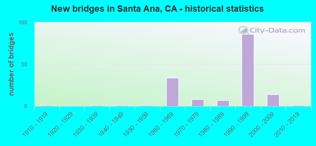
- New bridges - historical statistics
- 11910-1919
- 11930-1939
- 11940-1949
- 11950-1959
- 341960-1969
- 81970-1979
- 71980-1989
- 841990-1999
- 142000-2009
- 12010-2019
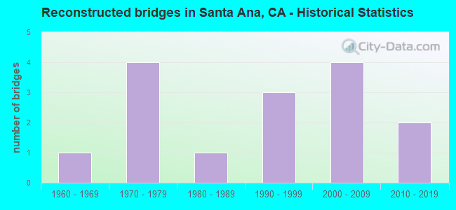
- Reconstructed bridges - Historical Statistics
- 11960-1969
- 41970-1979
- 11980-1989
- 31990-1999
- 42000-2009
- 22010-2019
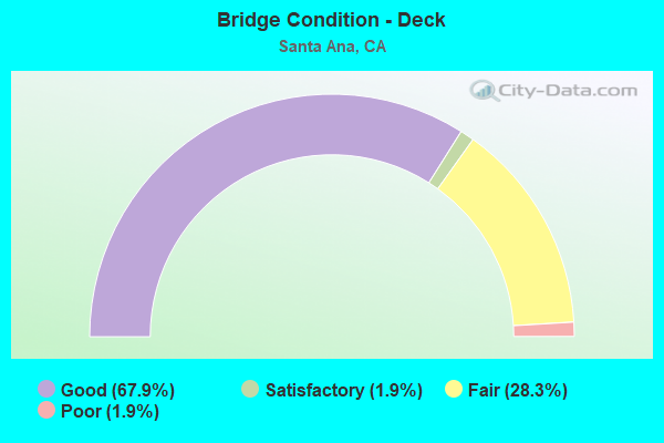
- Bridge Condition - Deck
- 67.9%Good
- 1.9%Satisfactory
- 28.3%Fair
- 1.9%Poor
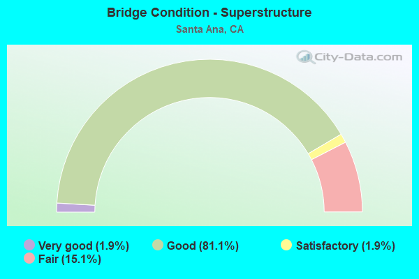
- Bridge Condition - Superstructure
- 1.9%Very good
- 81.1%Good
- 1.9%Satisfactory
- 15.1%Fair
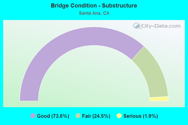
- Bridge Condition - Substructure
- 73.6%Good
- 24.5%Fair
- 1.9%Serious
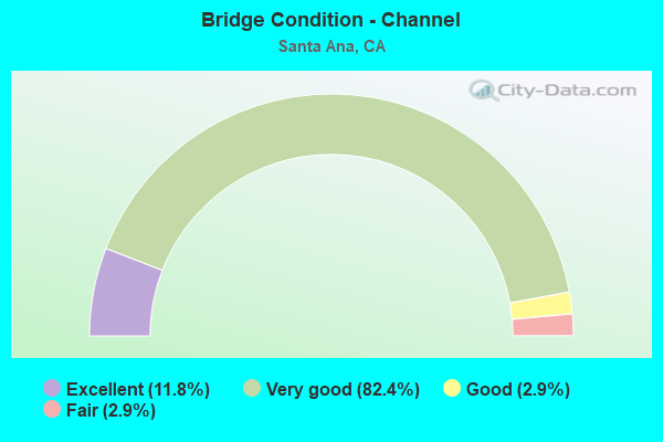
- Bridge Condition - Channel
- 11.8%Excellent
- 82.4%Very good
- 2.9%Good
- 2.9%Fair
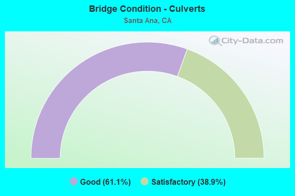
- Bridge Condition - Culverts
- 61.1%Good
- 38.9%Satisfactory
Find on map >> Show street view
Structure Number: 55 1083F, Location: 12-ORA-005-34.48-SA (Lat: 33.779375, Lng: -117.886933), Route carried "on" structure: Ramp Interstate 5, Year Built: 2008, Status: Open, Structure Length: 17.36m (56.96ft), Average Daily Traffic: 16,285 (year 2015), Truck Traffic: 3%, Average Future Daily Traffic: 17,614 (year 2042), Design Load: HS 20+Mod, Features Intersected: SANTA ANA RV, HESPERIAN
Minimum Vertical Clearance: 30+ m (98+ ft), Kilometerpoint: 34.480, Lanes on structure: 2, Lanes under structure: 2, Owner: State Highway Agency, Approaching Roadway Width: 15.3m (50.2ft), Skew: 2 degrees, Material/Design: Prestressed concrete continuous, Design/Construction: Box Beam or Girders - Multiple, Number Of Spans In Main Unit: 5, Length of Maximum Span: 43.9m (144.0ft), Curb-To-Curb Width: 15.3m (50.2ft), Out-to-Out Width: 16.2m (53.1ft)
Condition: Deck: Fair, Superstructure: Good, Substructure: Fair, Channel: Very good, Operating Rating: 54.1 metric tons, Method Used To Determine Operating Rating: Assigned rating based on Load Factor Design (LFD) reported in metric tons, Inventory Rating: 32.4 metric tons, Method Used To Determine Inventory Rating: Assigned rating based on Load Factor Design (LFD) reported in metric tons, Structural Evaluation: Somewhat better than minimum adequacy, Deck Geometry: Superior to present desirable criteria, Underclear: High priority of corrective action, Waterway Adequacy: Equal to present desirable criteria, Approach Roadway Alignment: Equal to present desirable criteria, Designated Inspection Frequency: Every 24 months, Inspection Date: January 2022, Deck Structure Type: Concrete Cast-file-Place
Find on map >> Show street view
Structure Number: 55 1084G, Location: 12-ORA-022-R10.43 (Lat: 33.778558, Lng: -117.877697), Route carried "on" structure: Ramp State highway 22, Year Built: 2008, Status: Open, Structure Length: 21.35m (70.05ft), Average Daily Traffic: 6,000 (year 2020), Truck Traffic: 3%, Average Future Daily Traffic: 6,000 (year 2038), Design Load: HS 20+Mod, Features Intersected: S5&S57-E22 & S57-S5 RMPS
Minimum Vertical Clearance: 30+ m (98+ ft), Kilometerpoint: 10.430, Lanes on structure: 2, Lanes under structure: 5, Owner: State Highway Agency, Approaching Roadway Width: 11.6m (38.1ft), Material/Design: Prestressed concrete continuous, Design/Construction: Box Beam or Girders - Multiple, Number Of Spans In Main Unit: 4, Length of Maximum Span: 59.2m (194.2ft), Curb-To-Curb Width: 11.6m (38.1ft), Out-to-Out Width: 12.6m (41.3ft)
Condition: Deck: Fair, Superstructure: Good, Substructure: Fair, Operating Rating: 54.1 metric tons, Method Used To Determine Operating Rating: Assigned rating based on Load Factor Design (LFD) reported in metric tons, Inventory Rating: 32.4 metric tons, Method Used To Determine Inventory Rating: Assigned rating based on Load Factor Design (LFD) reported in metric tons, Structural Evaluation: Somewhat better than minimum adequacy, Deck Geometry: Superior to present desirable criteria, Underclear: Equal to present desirable criteria, Approach Roadway Alignment: Equal to present desirable criteria, Designated Inspection Frequency: Every 24 months, Inspection Date: November 2020, Deck Structure Type: Concrete Cast-file-Place
Find on map >> Show street view
Structure Number: 55 1086G, Location: 12-ORA-022-R10.74-SA (Lat: 33.777942, Lng: -117.872108), Route carried "on" structure: Ramp State highway 22, Year Built: 2008, Status: Open, Structure Length: 9.84m (32.28ft), Average Daily Traffic: 11,000 (year 2020), Truck Traffic: 3%, Average Future Daily Traffic: 12,000 (year 2038), Design Load: HS 20+Mod, Features Intersected: STATE ROUTE 22 & RAMP
Minimum Vertical Clearance: 30+ m (98+ ft), Kilometerpoint: 10.740, Lanes on structure: 2, Lanes under structure: 8, Owner: State Highway Agency, Approaching Roadway Width: 11.9m (39.0ft), Skew: 9 degrees, Material/Design: Concrete continuous, Design/Construction: Box Beam or Girders - Multiple, Number Of Spans In Main Unit: 3, Length of Maximum Span: 34.9m (114.5ft), Curb-To-Curb Width: 11.9m (39.0ft), Out-to-Out Width: 12.9m (42.3ft)
Condition: Deck: Fair, Superstructure: Good, Substructure: Good, Operating Rating: 54.1 metric tons, Method Used To Determine Operating Rating: Assigned rating based on Load Factor Design (LFD) reported in metric tons, Inventory Rating: 32.4 metric tons, Method Used To Determine Inventory Rating: Assigned rating based on Load Factor Design (LFD) reported in metric tons, Structural Evaluation: Better than present minimum criteria, Deck Geometry: Superior to present desirable criteria, Underclear: Meets minimum limits, Approach Roadway Alignment: Equal to present minimum criteria, Designated Inspection Frequency: Every 24 months, Inspection Date: November 2020, Deck Structure Type: Concrete Cast-file-Place
Find on map >> Show street view
Structure Number: 55 1088F, Location: 12-ORA-005-34.55-SA (Lat: 33.779319, Lng: -117.890783), Route carried "on" structure: Ramp Interstate 5, Year Built: 2008, Status: Open, Structure Length: 9.10m (29.86ft), Average Daily Traffic: 16,285 (year 2015), Truck Traffic: 3%, Average Future Daily Traffic: 17,614 (year 2042), Design Load: HS 20+Mod, Features Intersected: W22-METROPOLITAN OFF RMP
Minimum Vertical Clearance: 30+ m (98+ ft), Kilometerpoint: 34.550, Lanes on structure: 2, Lanes under structure: 2, Owner: State Highway Agency, Approaching Roadway Width: 11.6m (38.1ft), Skew: 5 degrees, Material/Design: Concrete continuous, Design/Construction: Box Beam or Girders - Multiple, Number Of Spans In Main Unit: 3, Length of Maximum Span: 42.5m (139.4ft), Curb-To-Curb Width: 11.6m (38.1ft), Out-to-Out Width: 12.6m (41.3ft)
Condition: Deck: Good, Superstructure: Good, Substructure: Fair, Operating Rating: 54.1 metric tons, Method Used To Determine Operating Rating: Assigned rating based on Load Factor Design (LFD) reported in metric tons, Inventory Rating: 32.4 metric tons, Method Used To Determine Inventory Rating: Assigned rating based on Load Factor Design (LFD) reported in metric tons, Structural Evaluation: Somewhat better than minimum adequacy, Deck Geometry: Superior to present desirable criteria, Underclear: Equal to present minimum criteria, Approach Roadway Alignment: Equal to present desirable criteria, Designated Inspection Frequency: Every 24 months, Inspection Date: January 2022, Deck Structure Type: Concrete Cast-file-Place
Find on map >> Show street view
Structure Number: 55C0041L, Location: 0.8 MI W/O SEAL BEACH BL. (Lat: 33.759622, Lng: -118.091989), Route carried "on" structure: City street , Year Built: 1964, Status: Open, Structure Length: 2.07m (6.79ft), Average Daily Traffic: 13,000 (year 2020), Truck Traffic: 1%, Average Future Daily Traffic: 23,671 (year 2041), Design Load: HS 20, Features Intersected: LOS ALAMITOS CHANNEL, Facility Carried by Structure: WESTMINSTER AVE-WB
Minimum Vertical Clearance: 30+ m (98+ ft), Kilometerpoint: 0.000, Lanes on structure: 2, Base Highway Network: Yes, Owner: City or Municipal Highway Agency, Approaching Roadway Width: 10.7m (35.1ft), Material/Design: Concrete continuous, Design/Construction: Slab, Number Of Spans In Main Unit: 3, Length of Maximum Span: 7.9m (25.9ft), Curb-To-Curb Width: 10.9m (35.8ft), Out-to-Out Width: 11.6m (38.1ft)
Condition: Deck: Fair, Superstructure: Fair, Substructure: Good, Channel: Very good, Operating Rating: 51.5 metric tons, Method Used To Determine Operating Rating: Load Factor (LF), Inventory Rating: 31.1 metric tons, Method Used To Determine Inventory Rating: Load Factor (LF), Structural Evaluation: Somewhat better than minimum adequacy, Deck Geometry: Somewhat better than minimum adequacy, Waterway Adequacy: Equal to present desirable criteria, Approach Roadway Alignment: Equal to present desirable criteria, Designated Inspection Frequency: Every 24 months, Inspection Date: September 2020, Deck Structure Type: Concrete Cast-file-Place
Find on map >> Show street view
Structure Number: 55C0047, Location: 0.3 MI N SANTA CLARA AVE (Lat: 33.770508, Lng: -117.876003), Route carried "on" structure: City street , Year Built: 1930, Status: Open, Structure Length: 4.45m (14.60ft), Average Daily Traffic: 5,500 (year 2021), Truck Traffic: 1%, Average Future Daily Traffic: 10,688 (year 2041), Design Load: H 20, Features Intersected: SANTIAGO CREEK CHANNEL, Facility Carried by Structure: FLOWER ST
Minimum Vertical Clearance: 30+ m (98+ ft), Kilometerpoint: 0.000, Lanes on structure: 2, Owner: City or Municipal Highway Agency, Approaching Roadway Width: 19.8m (65.0ft), Skew: 4 degrees, Material/Design: Concrete, Design/Construction: Tee Beam, Number Of Spans In Main Unit: 4, Length of Maximum Span: 11.0m (36.1ft), Curb or Sidewalk Widths: Left: 1.5m (4.9ft), Right: 1.5m (4.9ft), Curb-To-Curb Width: 12.0m (39.4ft), Out-to-Out Width: 15.8m (51.8ft)
Condition: Deck: Fair, Superstructure: Good, Substructure: Good, Channel: Very good, Operating Rating: 48.0 metric tons, Method Used To Determine Operating Rating: Load and Resistance Factor Rating (LRFR) rating reported by rating factor(RF) method using HL-93 loadings, Inventory Rating: 35.6 metric tons, Method Used To Determine Inventory Rating: Load and Resistance Factor Rating (LRFR) rating reported by rating factor(RF) method using HL-93 loadings, Structural Evaluation: Better than present minimum criteria, Deck Geometry: Somewhat better than minimum adequacy, Waterway Adequacy: Equal to present desirable criteria, Approach Roadway Alignment: Equal to present desirable criteria, Designated Inspection Frequency: Every 24 months, Inspection Date: Febuary 2021, Deck Structure Type: Concrete Cast-file-Place, Wearing Surface/Protective System: Wearing Surface: Monolithic Concrete
Find on map >> Show street view
Structure Number: 55C0055, Location: 0.2 MI N/O ROUTE 5 FWY (Lat: 33.770817, Lng: -117.867219), Route carried "on" structure: City street , Year Built: 1918, Year Reconstructed: 1975, Status: Open, Structure Length: 6.19m (20.31ft), Average Daily Traffic: 37,000 (year 2019), Truck Traffic: 1%, Average Future Daily Traffic: 60,054 (year 2041), Design Load: H 15, Features Intersected: SANTIAGO CREEK CHANNEL, Facility Carried by Structure: MAIN ST
Minimum Vertical Clearance: 30+ m (98+ ft), Kilometerpoint: 0.000, Lanes on structure: 7, Base Highway Network: Yes, Owner: City or Municipal Highway Agency, Approaching Roadway Width: 26.7m (87.6ft), Material/Design: Concrete continuous, Design/Construction: Tee Beam, Number Of Spans In Main Unit: 5, Length of Maximum Span: 19.5m (64.0ft), Curb or Sidewalk Widths: Left: 1.8m (5.9ft), Right: 1.8m (5.9ft), Curb-To-Curb Width: 26.7m (87.6ft), Out-to-Out Width: 31.1m (102.0ft)
Condition: Deck: Good, Superstructure: Good, Substructure: Good, Channel: Very good, Operating Rating: 78.7 metric tons, Method Used To Determine Operating Rating: Load Factor (LF), Inventory Rating: 47.3 metric tons, Method Used To Determine Inventory Rating: Load Factor (LF), Structural Evaluation: Better than present minimum criteria, Deck Geometry: Meets minimum limits, Waterway Adequacy: Superior to present desirable criteria, Approach Roadway Alignment: Equal to present desirable criteria, Designated Inspection Frequency: Every 48 months, Inspection Date: Febuary 2019, Deck Structure Type: Concrete Cast-file-Place, Wearing Surface/Protective System: Wearing Surface: Bituminous
Find on map >> Show street view
Structure Number: 55C0073, Location: 0.2 MI E EUCLID ST (Lat: 33.744928, Lng: -117.933086), Route carried "on" structure: City street , Year Built: 1960, Status: Open, Structure Length: 0.67m (2.20ft), Average Daily Traffic: 25,000 (year 2021), Truck Traffic: 1%, Average Future Daily Traffic: 53,619 (year 2041), Features Intersected: E GARDEN GRV-WINTRBRG CH, Facility Carried by Structure: FIRST ST
Minimum Vertical Clearance: 30+ m (98+ ft), Kilometerpoint: 0.000, Lanes on structure: 7, Base Highway Network: Yes, Owner: City or Municipal Highway Agency, Approaching Roadway Width: 30.1m (98.8ft), Material/Design: Concrete, Design/Construction: Culvert, Number Of Spans In Main Unit: 2, Length of Maximum Span: 3.0m (9.8ft), Curb or Sidewalk Widths: Left: 3.0m (9.8ft), Right: 3.0m (9.8ft), Curb-To-Curb Width: 30.1m (98.8ft), Out-to-Out Width: 36.5m (119.8ft)
Condition: Channel: Very good, Culverts: Good, Operating Rating: 40.5 metric tons, Method Used To Determine Operating Rating: Field evaluation and documented engineering judgment, Inventory Rating: 24.3 metric tons, Method Used To Determine Inventory Rating: Field evaluation and documented engineering judgment, Structural Evaluation: Equal to present minimum criteria, Deck Geometry: Equal to present minimum criteria, Waterway Adequacy: Equal to present desirable criteria, Approach Roadway Alignment: Equal to present desirable criteria, Designated Inspection Frequency: Every 24 months, Inspection Date: Febuary 2021
Find on map >> Show street view
Structure Number: 55C0083, Location: 0.1 M S/O MC ARTHUR BLVD (Lat: 33.698686, Lng: -117.884997), Route carried "on" structure: City street , Year Built: 1961, Year Reconstructed: 1975, Status: Open, Structure Length: 1.52m (4.99ft), Average Daily Traffic: 42,000 (year 2021), Truck Traffic: 1%, Average Future Daily Traffic: 128,687 (year 2041), Features Intersected: SANTA ANA GARDENS CH, Facility Carried by Structure: BRISTOL ST
Minimum Vertical Clearance: 30+ m (98+ ft), Kilometerpoint: 0.000, Lanes on structure: 9, Base Highway Network: Yes, Owner: City or Municipal Highway Agency, Approaching Roadway Width: 32.8m (107.6ft), Skew: 39 degrees, Material/Design: Concrete, Design/Construction: Culvert, Number Of Spans In Main Unit: 3, Length of Maximum Span: 4.6m (15.1ft), Curb or Sidewalk Widths: Left: 2.4m (7.9ft), Right: 2.4m (7.9ft), Curb-To-Curb Width: 32.8m (107.6ft), Out-to-Out Width: 38.8m (127.3ft)
Condition: Channel: Very good, Culverts: Good, Operating Rating: 40.5 metric tons, Method Used To Determine Operating Rating: Field evaluation and documented engineering judgment, Inventory Rating: 24.3 metric tons, Method Used To Determine Inventory Rating: Field evaluation and documented engineering judgment, Structural Evaluation: Equal to present minimum criteria, Deck Geometry: Meets minimum limits, Waterway Adequacy: Equal to present desirable criteria, Approach Roadway Alignment: Equal to present desirable criteria, Designated Inspection Frequency: Every 24 months, Inspection Date: Febuary 2021
Find on map >> Show street view
Structure Number: 55C01, Location: 0.1 MI N/O MCFADDEN AVE (Lat: 33.739319, Lng: -117.937244), Route carried "on" structure: City street , Year Built: 1960, Status: Open, Structure Length: 0.73m (2.40ft), Average Daily Traffic: 43,000 (year 2021), Truck Traffic: 1%, Average Future Daily Traffic: 69,841 (year 2038), Features Intersected: E GARDEN GROVE W'BURG CH, Facility Carried by Structure: EUCLID AVE
Minimum Vertical Clearance: 30+ m (98+ ft), Kilometerpoint: 0.000, Lanes on structure: 6, Base Highway Network: Yes, Owner: City or Municipal Highway Agency, Approaching Roadway Width: 25.7m (84.3ft), Material/Design: Concrete continuous, Design/Construction: Culvert, Number Of Spans In Main Unit: 2, Length of Maximum Span: 3.4m (11.2ft), Curb or Sidewalk Widths: Left: 3.3m (10.8ft), Right: 3.3m (10.8ft), Curb-To-Curb Width: 25.7m (84.3ft), Out-to-Out Width: 32.1m (105.3ft)
Condition: Channel: Very good, Culverts: Good, Operating Rating: 40.5 metric tons, Method Used To Determine Operating Rating: Field evaluation and documented engineering judgment, Inventory Rating: 24.3 metric tons, Method Used To Determine Inventory Rating: Field evaluation and documented engineering judgment, Structural Evaluation: Equal to present minimum criteria, Deck Geometry: Somewhat better than minimum adequacy, Waterway Adequacy: Equal to present desirable criteria, Approach Roadway Alignment: Equal to present desirable criteria, Designated Inspection Frequency: Every 24 months, Inspection Date: Febuary 2021
Find on map >> Show street view
Structure Number: 55C0115, Location: 0.3 MI S/O MEMORY LANE (Lat: 33.769408, Lng: -117.884692), Route carried "on" structure: City street , Year Built: 1947, Year Reconstructed: 2003, Status: Open, Structure Length: 3.11m (10.20ft), Average Daily Traffic: 55,000 (year 2021), Truck Traffic: 1%, Average Future Daily Traffic: 81,501 (year 2041), Design Load: H 15, Features Intersected: SANTIAGO CREEK CHANNEL, Facility Carried by Structure: BRISTOL ST
Minimum Vertical Clearance: 30+ m (98+ ft), Kilometerpoint: 0.000, Lanes on structure: 4, Base Highway Network: Yes, Owner: City or Municipal Highway Agency, Approaching Roadway Width: 25.7m (84.3ft), Material/Design: Steel, Design/Construction: Stringer/Multi-beam, Number Of Spans In Main Unit: 3, Length of Maximum Span: 15.1m (49.5ft), Curb or Sidewalk Widths: Left: 2.1m (6.9ft), Right: 2.1m (6.9ft), Curb-To-Curb Width: 25.7m (84.3ft), Out-to-Out Width: 30.5m (100.1ft)
Condition: Deck: Fair, Superstructure: Good, Substructure: Good, Channel: Very good, Operating Rating: 38.2 metric tons, Method Used To Determine Operating Rating: Load and Resistance Factor Rating (LRFR) rating reported by rating factor(RF) method using HL-93 loadings, Inventory Rating: 29.5 metric tons, Method Used To Determine Inventory Rating: Load and Resistance Factor Rating (LRFR) rating reported by rating factor(RF) method using HL-93 loadings, Structural Evaluation: Better than present minimum criteria, Deck Geometry: Superior to present desirable criteria, Waterway Adequacy: Superior to present desirable criteria, Approach Roadway Alignment: Equal to present desirable criteria, Length Of Structure Improvement: 2.96m (9.71ft), Designated Inspection Frequency: Every 24 months, Inspection Date: Febuary 2021, Deck Structure Type: Concrete Cast-file-Place, Wearing Surface/Protective System: Wearing Surface: Monolithic Concrete
Find on map >> Show street view
Structure Number: 55C013, Location: 0.3 MI S/O ROUTE 91 FWY (Lat: 33.843317, Lng: -117.852556), Route carried "on" structure: City street , Year Built: 1963, Year Reconstructed: 2005, Status: Open, Structure Length: 29.35m (96.29ft), Average Daily Traffic: 22,000 (year 2021), Truck Traffic: 1%, Average Future Daily Traffic: 45,792 (year 2039), Features Intersected: SANTA ANA RIVER CHANNEL, Facility Carried by Structure: GLASSELL STREET
Minimum Vertical Clearance: 30+ m (98+ ft), Kilometerpoint: 0.000, Lanes on structure: 4, Base Highway Network: Yes, Owner: City or Municipal Highway Agency, Approaching Roadway Width: 21.2m (69.6ft), Skew: 30 degrees, Material/Design: Concrete continuous, Design/Construction: Tee Beam, Number Of Spans In Main Unit: 18, Length of Maximum Span: 16.8m (55.1ft), Curb-To-Curb Width: 21.2m (69.6ft), Out-to-Out Width: 26.1m (85.6ft)
Condition: Deck: Fair, Superstructure: Good, Substructure: Good, Channel: Very good, Operating Rating: 27.9 metric tons, Method Used To Determine Operating Rating: Field evaluation and documented engineering judgment, Inventory Rating: 16.8 metric tons, Method Used To Determine Inventory Rating: Field evaluation and documented engineering judgment, Structural Evaluation: Meets minimum limits, Deck Geometry: Superior to present desirable criteria, Waterway Adequacy: Superior to present desirable criteria, Approach Roadway Alignment: Equal to present desirable criteria, Designated Inspection Frequency: Every 24 months, Inspection Date: July 2021, Deck Structure Type: Concrete Cast-file-Place, Wearing Surface/Protective System: Wearing Surface: Monolithic Concrete
Find on map >> Show street view
Structure Number: 55C0148, Location: 0.1 MI W/O HARBOR BLVD (Lat: 33.714378, Lng: -117.921408), Route carried "on" structure: County highway , Year Built: 1961, Year Reconstructed: 1969, Status: Open, Structure Length: 7.74m (25.39ft), Average Daily Traffic: 25,000 (year 2019), Truck Traffic: 1%, Average Future Daily Traffic: 58,671 (year 2038), Design Load: HS 20, Features Intersected: SANTA ANA RIVER CHANNEL, Facility Carried by Structure: WARNER AVENUE
Minimum Vertical Clearance: 30+ m (98+ ft), Kilometerpoint: 0.000, Lanes on structure: 6, Base Highway Network: Yes, Owner: County Highway Agency, Approaching Roadway Width: 25.7m (84.3ft), Skew: 30 degrees, Material/Design: Concrete continuous, Design/Construction: Tee Beam, Number Of Spans In Main Unit: 6, Length of Maximum Span: 14.0m (45.9ft), Curb or Sidewalk Widths: Left: 0.0m, Right: 1.5m (4.9ft), Curb-To-Curb Width: 24.5m (80.4ft), Out-to-Out Width: 31.6m (103.7ft)
Condition: Deck: Good, Superstructure: Good, Substructure: Good, Channel: Very good, Operating Rating: 54.1 metric tons, Method Used To Determine Operating Rating: Assigned rating based on Load Factor Design (LFD) reported in metric tons, Inventory Rating: 32.4 metric tons, Method Used To Determine Inventory Rating: Assigned rating based on Load Factor Design (LFD) reported in metric tons, Structural Evaluation: Better than present minimum criteria, Deck Geometry: Somewhat better than minimum adequacy, Waterway Adequacy: Equal to present desirable criteria, Approach Roadway Alignment: Better than present minimum criteria, Designated Inspection Frequency: Every 48 months, Inspection Date: June 2021, Deck Structure Type: Concrete Cast-file-Place, Wearing Surface/Protective System: Wearing Surface: Integral Concrete
Find on map >> Show street view
Structure Number: 55C0163, Location: 0.4 MI W/O FAIRVIEW ST (Lat: 33.737394, Lng: -117.913119), Route carried "on" structure: City street , Year Built: 1964, Year Reconstructed: 1977, Status: Open, Structure Length: 10.67m (35.01ft), Average Daily Traffic: 22,000 (year 2021), Truck Traffic: 1%, Average Future Daily Traffic: 38,479 (year 2041), Design Load: HS 20, Features Intersected: SANTA ANA RIVER, Facility Carried by Structure: MCFADDEN AVENUE
Minimum Vertical Clearance: 30+ m (98+ ft), Kilometerpoint: 0.000, Lanes on structure: 4, Owner: City or Municipal Highway Agency, Approaching Roadway Width: 17.4m (57.1ft), Skew: 3 degrees, Material/Design: Concrete continuous, Design/Construction: Tee Beam, Number Of Spans In Main Unit: 7, Length of Maximum Span: 16.5m (54.1ft), Curb or Sidewalk Widths: Left: 1.5m (4.9ft), Right: 1.5m (4.9ft), Curb-To-Curb Width: 16.6m (54.5ft), Out-to-Out Width: 20.3m (66.6ft)
Condition: Deck: Good, Superstructure: Good, Substructure: Good, Channel: Very good, Operating Rating: 59.9 metric tons, Method Used To Determine Operating Rating: Load Factor (LF), Inventory Rating: 36.3 metric tons, Method Used To Determine Inventory Rating: Load Factor (LF), Structural Evaluation: Better than present minimum criteria, Deck Geometry: Somewhat better than minimum adequacy, Waterway Adequacy: Equal to present desirable criteria, Approach Roadway Alignment: Equal to present minimum criteria, Designated Inspection Frequency: Every 24 months, Inspection Date: Febuary 2021, Deck Structure Type: Concrete Cast-file-Place, Wearing Surface/Protective System: Wearing Surface: Integral Concrete
Find on map >> Show street view
Structure Number: 55C0164, Location: 0.5 MI W/O ROUTE 55 FWY (Lat: 33.733614, Lng: -117.842492), Route carried "on" structure: City street , Year Built: 1965, Status: Open, Structure Length: 0.67m (2.20ft), Average Daily Traffic: 21,000 (year 2021), Truck Traffic: 1%, Average Future Daily Traffic: 53,619 (year 2041), Features Intersected: SANTA ANA SANTA FE CHANL, Facility Carried by Structure: MCFADDEN AVENUE
Minimum Vertical Clearance: 30+ m (98+ ft), Kilometerpoint: 0.000, Lanes on structure: 4, Base Highway Network: Yes, Owner: City or Municipal Highway Agency, Approaching Roadway Width: 13.4m (44.0ft), Skew: 35 degrees, Material/Design: Concrete, Design/Construction: Culvert, Number Of Spans In Main Unit: 1, Length of Maximum Span: 6.4m (21.0ft), Curb or Sidewalk Widths: Left: 2.4m (7.9ft), Right: 1.7m (5.6ft), Curb-To-Curb Width: 13.4m (44.0ft), Out-to-Out Width: 18.4m (60.4ft)
Condition: Channel: Very good, Culverts: Good, Operating Rating: 40.5 metric tons, Method Used To Determine Operating Rating: Field evaluation and documented engineering judgment, Inventory Rating: 24.3 metric tons, Method Used To Determine Inventory Rating: Field evaluation and documented engineering judgment, Structural Evaluation: Equal to present minimum criteria, Deck Geometry: High priority of replacement, Waterway Adequacy: Equal to present desirable criteria, Approach Roadway Alignment: Equal to present desirable criteria, Designated Inspection Frequency: Every 24 months, Inspection Date: Febuary 2021, Deck Structure Type: Concrete Cast-file-Place, Wearing Surface/Protective System: Wearing Surface: Bituminous
Find on map >> Show street view
Structure Number: 55C0363, Location: 100' E/O FLOWER ST (Lat: 33.709550, Lng: -117.876692), Route carried "on" structure: City street , Year Built: 1971, Status: Open, Structure Length: 1.04m (3.41ft), Average Daily Traffic: 23,000 (year 2021), Truck Traffic: 1%, Average Future Daily Traffic: 55,764 (year 2041), Features Intersected: SANTA ANA DELHI CHANNEL, Facility Carried by Structure: DYER ROAD
Minimum Vertical Clearance: 30+ m (98+ ft), Kilometerpoint: 0.000, Lanes on structure: 5, Base Highway Network: Yes, Owner: City or Municipal Highway Agency, Approaching Roadway Width: 18.0m (59.1ft), Skew: 30 degrees, Material/Design: Concrete, Design/Construction: Culvert, Number Of Spans In Main Unit: 2, Length of Maximum Span: 4.9m (16.1ft), Curb or Sidewalk Widths: Left: 2.4m (7.9ft), Right: 2.4m (7.9ft), Curb-To-Curb Width: 18.0m (59.1ft), Out-to-Out Width: 24.6m (80.7ft)
Condition: Channel: Very good, Culverts: Good, Operating Rating: 40.5 metric tons, Method Used To Determine Operating Rating: Field evaluation and documented engineering judgment, Inventory Rating: 24.3 metric tons, Method Used To Determine Inventory Rating: Field evaluation and documented engineering judgment, Structural Evaluation: Equal to present minimum criteria, Deck Geometry: High priority of replacement, Waterway Adequacy: Equal to present desirable criteria, Approach Roadway Alignment: Equal to present desirable criteria, Designated Inspection Frequency: Every 24 months, Inspection Date: Febuary 2021
Find on map >> Show street view
Structure Number: 55C0364, Location: 100' E/O FLOWER ST (Lat: 33.705381, Lng: -117.876703), Route carried "on" structure: City street , Year Built: 1970, Status: Open, Structure Length: 1.10m (3.61ft), Average Daily Traffic: 5,000 (year 2021), Truck Traffic: 2%, Average Future Daily Traffic: 10,724 (year 2041), Features Intersected: SANTA ANA DELHI CHANNEL, Facility Carried by Structure: ALTON AVENUE
Minimum Vertical Clearance: 30+ m (98+ ft), Kilometerpoint: 0.000, Lanes on structure: 3, Owner: City or Municipal Highway Agency, Approaching Roadway Width: 11.0m (36.1ft), Material/Design: Concrete, Design/Construction: Culvert, Number Of Spans In Main Unit: 3, Length of Maximum Span: 3.4m (11.2ft), Curb or Sidewalk Widths: Left: 2.4m (7.9ft), Right: 2.4m (7.9ft), Curb-To-Curb Width: 13.3m (43.6ft), Out-to-Out Width: 18.5m (60.7ft)
Condition: Channel: Very good, Culverts: Satisfactory, Operating Rating: 40.5 metric tons, Method Used To Determine Operating Rating: Field evaluation and documented engineering judgment, Inventory Rating: 24.3 metric tons, Method Used To Determine Inventory Rating: Field evaluation and documented engineering judgment, Structural Evaluation: Equal to present minimum criteria, Deck Geometry: Somewhat better than minimum adequacy, Waterway Adequacy: Equal to present desirable criteria, Approach Roadway Alignment: Equal to present desirable criteria, Designated Inspection Frequency: Every 24 months, Inspection Date: Febuary 2021, Deck Structure Type: Concrete Cast-file-Place
Find on map >> Show street view
Structure Number: 55C0365, Location: 100' E/O FLOWER ST (Lat: 33.699881, Lng: -117.876772), Route carried "on" structure: City street , Year Built: 1971, Status: Open, Structure Length: 1.10m (3.61ft), Average Daily Traffic: 34,000 (year 2021), Truck Traffic: 1%, Average Future Daily Traffic: 64,343 (year 2041), Features Intersected: SANTA ANA DELHI CHANNEL, Facility Carried by Structure: MACARTHUR BLVD
Minimum Vertical Clearance: 30+ m (98+ ft), Kilometerpoint: 0.000, Lanes on structure: 7, Base Highway Network: Yes, Owner: City or Municipal Highway Agency, Approaching Roadway Width: 23.8m (78.1ft), Skew: 30 degrees, Material/Design: Concrete, Design/Construction: Culvert, Number Of Spans In Main Unit: 3, Length of Maximum Span: 3.4m (11.2ft), Curb or Sidewalk Widths: Left: 1.3m (4.3ft), Right: 1.3m (4.3ft), Curb-To-Curb Width: 23.8m (78.1ft), Out-to-Out Width: 28.2m (92.5ft)
Condition: Channel: Very good, Culverts: Satisfactory, Operating Rating: 40.5 metric tons, Method Used To Determine Operating Rating: Field evaluation and documented engineering judgment, Inventory Rating: 24.3 metric tons, Method Used To Determine Inventory Rating: Field evaluation and documented engineering judgment, Structural Evaluation: Equal to present minimum criteria, Deck Geometry: High priority of replacement, Waterway Adequacy: Equal to present desirable criteria, Approach Roadway Alignment: Equal to present desirable criteria, Designated Inspection Frequency: Every 24 months, Inspection Date: Febuary 2021, Deck Structure Type: Concrete Cast-file-Place
Find on map >> Show street view
Structure Number: 55C0366, Location: 100' N/O SUNFLOWER AVE (Lat: 33.694714, Lng: -117.876803), Route carried "on" structure: City street , Year Built: 1973, Status: Open, Structure Length: 1.40m (4.59ft), Average Daily Traffic: 8,000 (year 2019), Truck Traffic: 1%, Average Future Daily Traffic: 17,157 (year 2041), Features Intersected: SANTA ANA DELHI CHANNEL, Facility Carried by Structure: FLOWER ST
Minimum Vertical Clearance: 30+ m (98+ ft), Kilometerpoint: 0.000, Lanes on structure: 5, Base Highway Network: Yes, Owner: City or Municipal Highway Agency, Approaching Roadway Width: 16.5m (54.1ft), Skew: 24 degrees, Material/Design: Concrete, Design/Construction: Culvert, Number Of Spans In Main Unit: 3, Length of Maximum Span: 3.7m (12.1ft), Curb or Sidewalk Widths: Left: 2.1m (6.9ft), Right: 0.7m (2.3ft), Curb-To-Curb Width: 16.5m (54.1ft), Out-to-Out Width: 21.1m (69.2ft)
Condition: Channel: Very good, Culverts: Good, Operating Rating: 54.1 metric tons, Method Used To Determine Operating Rating: Field evaluation and documented engineering judgment, Inventory Rating: 32.4 metric tons, Method Used To Determine Inventory Rating: Field evaluation and documented engineering judgment, Structural Evaluation: Better than present minimum criteria, Deck Geometry: High priority of replacement, Waterway Adequacy: Superior to present desirable criteria, Approach Roadway Alignment: Equal to present desirable criteria, Designated Inspection Frequency: Every 48 months, Inspection Date: Febuary 2019
Find on map >> Show street view
Structure Number: 55C0367, Location: 100' N/O SUNFLOWER AVE (Lat: 33.694336, Lng: -117.880331), Route carried "on" structure: City street , Year Built: 1973, Status: Open, Structure Length: 1.55m (5.09ft), Average Daily Traffic: 2,000 (year 2019), Truck Traffic: 1%, Average Future Daily Traffic: 1,636 (year 2041), Features Intersected: SANTA ANA DELHI CHANNEL, Facility Carried by Structure: STEVENS AVE
Minimum Vertical Clearance: 30+ m (98+ ft), Kilometerpoint: 0.000, Lanes on structure: 2, Owner: City or Municipal Highway Agency, Approaching Roadway Width: 7.9m (25.9ft), Material/Design: Concrete, Design/Construction: Culvert, Number Of Spans In Main Unit: 3, Length of Maximum Span: 4.9m (16.1ft), Curb or Sidewalk Widths: Left: 0.7m (2.3ft), Right: 1.5m (4.9ft), Curb-To-Curb Width: 7.9m (25.9ft), Out-to-Out Width: 10.5m (34.4ft)
Condition: Channel: Excellent, Culverts: Good, Operating Rating: 54.1 metric tons, Method Used To Determine Operating Rating: Field evaluation and documented engineering judgment, Inventory Rating: 32.4 metric tons, Method Used To Determine Inventory Rating: Field evaluation and documented engineering judgment, Structural Evaluation: Better than present minimum criteria, Deck Geometry: Meets minimum limits, Waterway Adequacy: Superior to present desirable criteria, Approach Roadway Alignment: Equal to present minimum criteria, Designated Inspection Frequency: Every 48 months, Inspection Date: Febuary 2019
Find on map >> Show street view
Structure Number: 55C0372, Location: 0.6 MI E/O HARBOR BLVD (Lat: 33.748828, Lng: -117.909519), Route carried "on" structure: City street , Year Built: 1962, Year Reconstructed: 2010, Status: Open, Structure Length: 9.75m (31.99ft), Average Daily Traffic: 13,000 (year 2019), Truck Traffic: 1%, Average Future Daily Traffic: 27,788 (year 2041), Design Load: HS 20, Features Intersected: SANTA ANA RIVER CHANNEL, Facility Carried by Structure: 5TH STREET
Minimum Vertical Clearance: 30+ m (98+ ft), Kilometerpoint: 0.000, Lanes on structure: 4, Owner: City or Municipal Highway Agency, Approaching Roadway Width: 19.2m (63.0ft), Skew: 2 degrees, Material/Design: Concrete continuous, Design/Construction: Tee Beam, Number Of Spans In Main Unit: 7, Length of Maximum Span: 14.9m (48.9ft), Curb or Sidewalk Widths: Left: 0.8m (2.6ft), Right: 0.8m (2.6ft), Curb-To-Curb Width: 15.8m (51.8ft), Out-to-Out Width: 19.5m (64.0ft)
Condition: Deck: Good, Superstructure: Good, Substructure: Good, Channel: Excellent, Operating Rating: 62.9 metric tons, Method Used To Determine Operating Rating: Load Factor (LF), Inventory Rating: 37.9 metric tons, Method Used To Determine Inventory Rating: Load Factor (LF), Structural Evaluation: Better than present minimum criteria, Deck Geometry: Meets minimum limits, Waterway Adequacy: Superior to present desirable criteria, Approach Roadway Alignment: Better than present minimum criteria, Designated Inspection Frequency: Every 48 months, Inspection Date: Febuary 2019, Deck Structure Type: Concrete Cast-file-Place, Wearing Surface/Protective System: Wearing Surface: Monolithic Concrete
Find on map >> Show street view
Structure Number: 55C0373, Location: 0.5 MI E/O HARBOR BLVD (Lat: 33.699911, Lng: -117.910167), Route carried "on" structure: City street , Year Built: 1962, Status: Open, Structure Length: 0.70m (2.30ft), Average Daily Traffic: 29,000 (year 2021), Truck Traffic: 1%, Average Future Daily Traffic: 46,561 (year 2038), Features Intersected: GREENVILLE-BANNING CHAN, Facility Carried by Structure: MAC ARTHUR BLVD
Minimum Vertical Clearance: 30+ m (98+ ft), Kilometerpoint: 0.000, Lanes on structure: 7, Base Highway Network: Yes, Owner: City or Municipal Highway Agency, Approaching Roadway Width: 25.1m (82.3ft), Skew: 1 degrees, Material/Design: Concrete, Design/Construction: Culvert, Number Of Spans In Main Unit: 2, Length of Maximum Span: 3.0m (9.8ft), Curb or Sidewalk Widths: Left: 3.0m (9.8ft), Right: 3.0m (9.8ft), Curb-To-Curb Width: 25.1m (82.3ft), Out-to-Out Width: 31.5m (103.3ft)
Condition: Channel: Very good, Culverts: Satisfactory, Operating Rating: 40.5 metric tons, Method Used To Determine Operating Rating: Field evaluation and documented engineering judgment, Inventory Rating: 24.3 metric tons, Method Used To Determine Inventory Rating: Field evaluation and documented engineering judgment, Structural Evaluation: Equal to present minimum criteria, Deck Geometry: High priority of replacement, Waterway Adequacy: Equal to present desirable criteria, Approach Roadway Alignment: Equal to present desirable criteria, Designated Inspection Frequency: Every 24 months, Inspection Date: Febuary 2021, Deck Structure Type: Concrete Cast-file-Place, Wearing Surface/Protective System: Wearing Surface: Bituminous
Find on map >> Show street view
Structure Number: 55C042, Location: 150' N/O IOWA STREET (Lat: 33.691303, Lng: -117.926494), Route carried "on" structure: City street , Year Built: 1970, Status: Open, Structure Length: 1.19m (3.90ft), Average Daily Traffic: 300 (year 2013), Truck Traffic: 1%, Average Future Daily Traffic: 317 (year 2038), Design Load: HS 20, Features Intersected: GRNVILLE-BANNING CHANNEL, Facility Carried by Structure: NEW HAMPSHIRE DR.
Minimum Vertical Clearance: 30+ m (98+ ft), Kilometerpoint: 0.000, Lanes on structure: 2, Owner: City or Municipal Highway Agency, Approaching Roadway Width: 7.7m (25.3ft), Material/Design: Concrete, Design/Construction: Culvert, Number Of Spans In Main Unit: 3, Length of Maximum Span: 3.7m (12.1ft), Curb or Sidewalk Widths: Left: 1.5m (4.9ft), Right: 1.5m (4.9ft), Curb-To-Curb Width: 7.7m (25.3ft), Out-to-Out Width: 11.1m (36.4ft)
Condition: Channel: Very good, Culverts: Good, Operating Rating: 40.5 metric tons, Method Used To Determine Operating Rating: Field evaluation and documented engineering judgment, Inventory Rating: 24.3 metric tons, Method Used To Determine Inventory Rating: Field evaluation and documented engineering judgment, Structural Evaluation: Equal to present minimum criteria, Deck Geometry: Somewhat better than minimum adequacy, Waterway Adequacy: Superior to present desirable criteria, Approach Roadway Alignment: Equal to present desirable criteria, Designated Inspection Frequency: Every 24 months, Inspection Date: October 2021
Find on map >> Show street view
Structure Number: 55C0423, Location: 0.2 MI E/O FAIRVIEW ST (Lat: 33.759761, Lng: -117.901128), Route carried "on" structure: City street , Year Built: 1977, Status: Open, Structure Length: 10.91m (35.79ft), Average Daily Traffic: 33,000 (year 2021), Truck Traffic: 1%, Average Future Daily Traffic: 70,777 (year 2041), Features Intersected: SANTA ANA RIVER CHANNEL, Facility Carried by Structure: 17TH STREET
Minimum Vertical Clearance: 30+ m (98+ ft), Kilometerpoint: 0.000, Lanes on structure: 6, Base Highway Network: Yes, Owner: City or Municipal Highway Agency, Approaching Roadway Width: 24.3m (79.7ft), Skew: 3 degrees, Material/Design: Prestressed concrete continuous, Design/Construction: Stringer/Multi-beam, Number Of Spans In Main Unit: 4, Length of Maximum Span: 27.1m (88.9ft), Curb or Sidewalk Widths: Left: 1.5m (4.9ft), Right: 1.5m (4.9ft), Curb-To-Curb Width: 24.3m (79.7ft), Out-to-Out Width: 28.0m (91.9ft)
Condition: Deck: Fair, Superstructure: Good, Substructure: Good, Channel: Very good, Operating Rating: 71.9 metric tons, Method Used To Determine Operating Rating: Load and Resistance Factor Rating (LRFR) rating reported by rating factor(RF) method using HL-93 loadings, Inventory Rating: 52.2 metric tons, Method Used To Determine Inventory Rating: Load and Resistance Factor Rating (LRFR) rating reported by rating factor(RF) method using HL-93 loadings, Structural Evaluation: Better than present minimum criteria, Deck Geometry: Somewhat better than minimum adequacy, Waterway Adequacy: Superior to present desirable criteria, Approach Roadway Alignment: Equal to present desirable criteria, Designated Inspection Frequency: Every 24 months, Inspection Date: Febuary 2021, Deck Structure Type: Concrete Cast-file-Place, Wearing Surface/Protective System: Wearing Surface: Monolithic Concrete
Find on map >> Show street view
Structure Number: 55C0429, Location: 200' N/O TAMPION AVE (Lat: 33.739233, Lng: -117.940378), Route carried "on" structure: City street , Year Built: 1961, Status: Open, Structure Length: 0.67m (2.20ft), Average Daily Traffic: 2,000 (year 2021), Truck Traffic: 1%, Average Future Daily Traffic: 2,145 (year 2041), Features Intersected: E GRDN GRVE WINTRBG CHAN, Facility Carried by Structure: DEMING STREET
Minimum Vertical Clearance: 30+ m (98+ ft), Kilometerpoint: 0.000, Lanes on structure: 2, Owner: City or Municipal Highway Agency, Approaching Roadway Width: 10.8m (35.4ft), Material/Design: Concrete, Design/Construction: Culvert, Number Of Spans In Main Unit: 2, Length of Maximum Span: 3.0m (9.8ft), Curb or Sidewalk Widths: Left: 3.6m (11.8ft), Right: 3.4m (11.2ft), Curb-To-Curb Width: 10.8m (35.4ft), Out-to-Out Width: 18.3m (60.0ft)
Condition: Channel: Very good, Culverts: Good, Operating Rating: 40.5 metric tons, Method Used To Determine Operating Rating: Field evaluation and documented engineering judgment, Inventory Rating: 24.3 metric tons, Method Used To Determine Inventory Rating: Field evaluation and documented engineering judgment, Structural Evaluation: Equal to present minimum criteria, Deck Geometry: Equal to present minimum criteria, Waterway Adequacy: Equal to present desirable criteria, Approach Roadway Alignment: Equal to present desirable criteria, Designated Inspection Frequency: Every 24 months, Inspection Date: Febuary 2021
Find on map >> Show street view
Structure Number: 55C0447, Location: 0.2 MI W/O NEWHOPE ST (Lat: 33.748722, Lng: -117.932844), Route carried "on" structure: City street , Year Built: 1950, Status: Open, Structure Length: 0.64m (2.10ft), Average Daily Traffic: 4,000 (year 2021), Truck Traffic: 1%, Average Future Daily Traffic: 2,117 (year 2038), Features Intersected: EAST GG-WINTERSBURG CHAN, Facility Carried by Structure: 5TH ST
Minimum Vertical Clearance: 30+ m (98+ ft), Kilometerpoint: 0.000, Lanes on structure: 2, Owner: City or Municipal Highway Agency, Approaching Roadway Width: 10.5m (34.4ft), Skew: 1 degrees, Material/Design: Concrete, Design/Construction: Culvert, Number Of Spans In Main Unit: 2, Length of Maximum Span: 3.0m (9.8ft), Curb or Sidewalk Widths: Left: 1.2m (3.9ft), Right: 3.6m (11.8ft), Curb-To-Curb Width: 10.5m (34.4ft), Out-to-Out Width: 18.3m (60.0ft)
Condition: Channel: Very good, Culverts: Good, Operating Rating: 40.5 metric tons, Method Used To Determine Operating Rating: Field evaluation and documented engineering judgment, Inventory Rating: 24.3 metric tons, Method Used To Determine Inventory Rating: Field evaluation and documented engineering judgment, Structural Evaluation: Equal to present minimum criteria, Deck Geometry: Somewhat better than minimum adequacy, Waterway Adequacy: Equal to present desirable criteria, Approach Roadway Alignment: Equal to present desirable criteria, Designated Inspection Frequency: Every 24 months, Inspection Date: Febuary 2021
Find on map >> Show street view
Structure Number: 55C0513, Location: 0.2 MI S/O WESTMINSTER AV (Lat: 33.756414, Lng: -117.902731), Route carried "on" structure: City street , Year Built: 1963, Status: Open, Structure Length: 15.12m (49.61ft), Average Daily Traffic: 38,544 (year 2021), Truck Traffic: 1%, Average Future Daily Traffic: 72,679 (year 2041), Features Intersected: SANTA ANA RIVER CHANNEL, Facility Carried by Structure: FAIRVIEW STREET
Minimum Vertical Clearance: 30+ m (98+ ft), Kilometerpoint: 0.000, Lanes on structure: 4, Base Highway Network: Yes, Owner: City or Municipal Highway Agency, Approaching Roadway Width: 16.0m (52.5ft), Skew: 5 degrees, Material/Design: Concrete continuous, Design/Construction: Tee Beam, Number Of Spans In Main Unit: 9, Length of Maximum Span: 17.7m (58.1ft), Curb-To-Curb Width: 15.5m (50.9ft), Out-to-Out Width: 15.8m (51.8ft)
Condition: Deck: Poor, Superstructure: Good, Substructure: Good, Channel: Excellent, Operating Rating: 25.3 metric tons, Method Used To Determine Operating Rating: Load and Resistance Factor Rating (LRFR) rating reported by rating factor(RF) method using HL-93 loadings, Inventory Rating: 18.1 metric tons, Method Used To Determine Inventory Rating: Load and Resistance Factor Rating (LRFR) rating reported by rating factor(RF) method using HL-93 loadings, Structural Evaluation: Meets minimum limits, Deck Geometry: Meets minimum limits, Waterway Adequacy: Superior to present desirable criteria, Approach Roadway Alignment: Equal to present desirable criteria, Length Of Structure Improvement: 15.12m (49.61ft), Designated Inspection Frequency: Every 24 months, Inspection Date: Febuary 2021, Bridge Improvement Cost: $2,396,000, Roadway Improvement Cost: $479,000, Total Project Cost: $4,025,000 ( Estimate for 2017), Deck Structure Type: Concrete Cast-file-Place, Wearing Surface/Protective System: Wearing Surface: Monolithic Concrete
Find on map >> Show street view
Structure Number: 55C0631, Location: 0.2 MI N/O WARNER AVENUE (Lat: 33.716097, Lng: -117.920217), Route carried "on" structure: County highway , Year Built: 1994, Status: Open, Structure Length: 12.01m (39.40ft), Average Daily Traffic: 54,000 (year 2019), Truck Traffic: 1%, Average Future Daily Traffic: 71,555 (year 2038), Design Load: HS 20+Mod, Features Intersected: SANTA ANA RIVER CHANNEL, Facility Carried by Structure: HARBOR BOULEVARD
Minimum Vertical Clearance: 30+ m (98+ ft), Kilometerpoint: 0.000, Lanes on structure: 6, Base Highway Network: Yes, Owner: County Highway Agency, Approaching Roadway Width: 26.8m (87.9ft), Skew: 24 degrees, Material/Design: Prestressed concrete continuous, Number Of Spans In Main Unit: 5, Length of Maximum Span: 25.9m (85.0ft), Curb or Sidewalk Widths: Left: 1.8m (5.9ft), Right: 1.8m (5.9ft), Curb-To-Curb Width: 26.8m (87.9ft), Out-to-Out Width: 30.5m (100.1ft)
Condition: Deck: Fair, Superstructure: Good, Substructure: Good, Channel: Very good, Operating Rating: 54.1 metric tons, Method Used To Determine Operating Rating: Assigned rating based on Load Factor Design (LFD) reported in metric tons, Inventory Rating: 32.4 metric tons, Method Used To Determine Inventory Rating: Assigned rating based on Load Factor Design (LFD) reported in metric tons, Structural Evaluation: Better than present minimum criteria, Deck Geometry: Better than present minimum criteria, Waterway Adequacy: Equal to present desirable criteria, Approach Roadway Alignment: Equal to present desirable criteria, Designated Inspection Frequency: Every 24 months, Inspection Date: June 2021, Deck Structure Type: Concrete Cast-file-Place
Find on map >> Show street view
Structure Number: 55C0689, Location: 0.5 MI E/O HARBOR BLVD (Lat: 33.745106, Lng: -117.911372), Route carried "on" structure: City street , Year Built: 2012, Status: Open, Structure Length: 9.75m (31.99ft), Average Daily Traffic: 30,000 (year 2021), Truck Traffic: 1%, Average Future Daily Traffic: 53,226 (year 2038), Design Load: HS 20, Features Intersected: SANTA ANA RIVER CHANNEL, Facility Carried by Structure: FIRST STREET
Minimum Vertical Clearance: 30+ m (98+ ft), Kilometerpoint: 0.000, Lanes on structure: 6, Base Highway Network: Yes, Owner: City or Municipal Highway Agency, Approaching Roadway Width: 21.4m (70.2ft), Skew: 31 degrees, Material/Design: Prestressed concrete, Design/Construction: Stringer/Multi-beam, Number Of Spans In Main Unit: 3, Length of Maximum Span: 36.6m (120.1ft), Curb or Sidewalk Widths: Left: 2.4m (7.9ft), Right: 2.4m (7.9ft), Curb-To-Curb Width: 21.4m (70.2ft), Out-to-Out Width: 28.0m (91.9ft)
Condition: Deck: Good, Superstructure: Good, Substructure: Good, Channel: Excellent, Operating Rating: 54.1 metric tons, Method Used To Determine Operating Rating: Assigned rating based on Load Factor Design (LFD) reported in metric tons, Inventory Rating: 32.4 metric tons, Method Used To Determine Inventory Rating: Assigned rating based on Load Factor Design (LFD) reported in metric tons, Structural Evaluation: Better than present minimum criteria, Deck Geometry: High priority of replacement, Waterway Adequacy: Superior to present desirable criteria, Approach Roadway Alignment: Equal to present desirable criteria, Designated Inspection Frequency: Every 24 months, Inspection Date: Febuary 2021, Deck Structure Type: Concrete Cast-file-Place
Find on map >> Show street view
Structure Number: DAPFORLIG000748, Location: S OLD MAN CANYON SEC 13 W (Lat: 35.989469, Lng: -121.195300), Route carried "on" structure: Other road , Year Built: 2002, Status: Closed, Structure Length: 1.83m (6.00ft), Average Daily Traffic: 1 (year 2015), Truck Traffic: 1%, Average Future Daily Traffic: 2 (year 2037), Design Load: HS 20, Features Intersected: DRAINAGE KD RESERVOIR, Facility Carried by Structure: RUBY CANYON ROAD
Minimum Vertical Clearance: 30+ m (98+ ft), Kilometerpoint: 0.000, Lanes on structure: 1, Owner: Army, Approaching Roadway Width: 3.8m (12.5ft), Skew: 5 degrees, Material/Design: Steel, Design/Construction: Truss - Thru, Number Of Spans In Main Unit: 1, Length of Maximum Span: 18.3m (60.0ft), Curb-To-Curb Width: 4.3m (14.1ft), Out-to-Out Width: 5.6m (18.4ft)
Condition: Deck: Satisfactory, Superstructure: Satisfactory, Substructure: Serious, Channel: Fair, Deck Geometry: Equal to present minimum criteria, Waterway Adequacy: Somewhat better than minimum adequacy, Approach Roadway Alignment: Equal to present minimum criteria, Bridge Posting: Required (Relationship of Operating Rating to Maximum Legal Load: > 39.9% below), Length Of Structure Improvement: 2.55m (8.37ft), Designated Inspection Frequency: Every 24 months, Critical Feature Inspection Frequency: Every 24 months, Inspection Date: March 2017, Critical Feature Inspection Date: March 2017, Bridge Improvement Cost: $15,000, Roadway Improvement Cost: $2,000, Total Project Cost: $17,000 ( Estimate for 2017), Deck Structure Type: Wood or Timber, Wearing Surface/Protective System: Wearing Surface: Wood or Timber
Find on map >> Show street view
Structure Number: 55 0343, Location: 12-ORA-022-R10.01-SA (Lat: 33.778650, Lng: -117.884372), Route carried "under" structure: City street M017, Year Built: 1963, Structure Length: 0. m, Average Daily Traffic: 17,000 (year 2020), Truck Traffic: 3%, Features Intersected: BRISTOL STREET, Facility Carried by Structure: STATE ROUTE 22
Minimum Vertical Clearance: 4.60m (15.09ft), Kilometerpoint: 0.000, Lanes on structure: 11, Lanes under structure: 4, Material/Design: Concrete continuous, Design/Construction: Box Beam or Girders - Multiple, Length of Maximum Span: 23.8m (78.1ft)
Find on map >> Show street view
Structure Number: 55 0344H, Location: 12-ORA-005-34.38-SA (Lat: 33.779714, Lng: -117.883431), Route carried "under" structure: Ramp State highway 57, Year Built: 1963, Structure Length: 0. m, Average Daily Traffic: 8,600 (year 2009), Truck Traffic: 3%, Features Intersected: S57-BRISTOL ST OFF-RAMP
Minimum Vertical Clearance: 4.92m (16.14ft), Kilometerpoint: 11.820, Lanes on structure: 3, Lanes under structure: 2, Material/Design: Concrete continuous, Design/Construction: Box Beam or Girders - Multiple, Length of Maximum Span: 15.2m (49.9ft)
Find on map >> Show street view
Structure Number: 55 0357, Location: 12-ORA-022-R10.87-SA (Lat: 33.778528, Lng: -117.869583), Route carried "under" structure: State highway 22, Year Built: 1963, Structure Length: 0. m, Average Daily Traffic: 150,000 (year 2020), Truck Traffic: 4%, Features Intersected: STATE ROUTE 22, Facility Carried by Structure: BEDFORD ROAD
Minimum Vertical Clearance: 4.57m (14.99ft), Kilometerpoint: 10.870, Lanes on structure: 2, Lanes under structure: 10, Material/Design: Concrete continuous, Design/Construction: Box Beam or Girders - Multiple, Length of Maximum Span: 27.7m (90.9ft)
Find on map >> Show street view
Structure Number: 55 0363, Location: 12-ORA-022-R10.99-SA (Lat: 33.778528, Lng: -117.867483), Route carried "under" structure: State highway 22, Year Built: 1963, Structure Length: 0. m, Average Daily Traffic: 150,000 (year 2020), Truck Traffic: 4%, Features Intersected: STATE ROUTE 22, Facility Carried by Structure: MAIN ST
Minimum Vertical Clearance: 4.57m (14.99ft), Kilometerpoint: 10.990, Lanes on structure: 6, Lanes under structure: 10, Material/Design: Concrete continuous, Design/Construction: Box Beam or Girders - Multiple, Length of Maximum Span: 27.4m (89.9ft)
Find on map >> Show street view
Structure Number: 55 0383, Location: 12-ORA-022-R12.36-SA (Lat: 33.776369, Lng: -117.844561), Route carried "under" structure: State highway 22, Year Built: 1967, Structure Length: 0. m, Average Daily Traffic: 150,000 (year 2020), Truck Traffic: 4%, Features Intersected: STATE ROUTE 22, Facility Carried by Structure: CAMBRIDGE STREET
Minimum Vertical Clearance: 5.07m (16.63ft), Kilometerpoint: 12.360, Lanes on structure: 2, Lanes under structure: 10, Material/Design: Concrete continuous, Design/Construction: Box Beam or Girders - Multiple, Length of Maximum Span: 29.6m (97.1ft)
Find on map >> Show street view
Structure Number: 55 0393, Location: 12-ORA-055-R9.44-SA (Lat: 33.726303, Lng: -117.834722), Route carried "under" structure: City street M032, Year Built: 1964, Structure Length: 0. m, Average Daily Traffic: 18,000 (year 2017), Truck Traffic: 3%, Features Intersected: EDINGER AVE, Facility Carried by Structure: STATE ROUTE 55
Minimum Vertical Clearance: 6.85m (22.47ft), Kilometerpoint: 0.000, Lanes on structure: 12, Lanes under structure: 6, Material/Design: Concrete continuous, Design/Construction: Box Beam or Girders - Multiple, Length of Maximum Span: 17.7m (58.1ft)
Find on map >> Show street view
Structure Number: 55 0394, Location: 12-ORA-055-R8.50-SA (Lat: 33.715572, Lng: -117.845328), Route carried "under" structure: State highway 55, Year Built: 1988, Structure Length: 0. m, Average Daily Traffic: 288,600 (year 2017), Truck Traffic: 2%, Features Intersected: STATE ROUTE 55, Facility Carried by Structure: WARNER AVE
Minimum Vertical Clearance: 5.36m (17.59ft), Kilometerpoint: 8.500, Lanes on structure: 6, Lanes under structure: 11, Material/Design: Prestressed concrete continuous, Design/Construction: Box Beam or Girders - Multiple, Length of Maximum Span: 40.2m (131.9ft)
Find on map >> Show street view
Structure Number: 55 0409, Location: 12-ORA-055-R7.87-SA (Lat: 33.708311, Lng: -117.851661), Route carried "under" structure: City street M029, Year Built: 1966, Structure Length: 0. m, Average Daily Traffic: 20,000 (year 2009), Truck Traffic: 3%, Features Intersected: DYER RD, Facility Carried by Structure: STATE ROUTE 55
Minimum Vertical Clearance: 4.62m (15.16ft), Kilometerpoint: 0.000, Lanes on structure: 12, Lanes under structure: 6, Material/Design: Concrete continuous, Design/Construction: Box Beam or Girders - Multiple, Length of Maximum Span: 26.2m (86.0ft)
Find on map >> Show street view
Structure Number: 55 041, Location: 12-ORA-055-R6.99-SA (Lat: 33.698239, Lng: -117.861353), Route carried "under" structure: City street M034, Year Built: 1966, Structure Length: 0. m, Average Daily Traffic: 20,000 (year 2011), Truck Traffic: 3%, Features Intersected: MACARTHUR BLVD, Facility Carried by Structure: STATE ROUTE 55
Minimum Vertical Clearance: 4.97m (16.31ft), Kilometerpoint: 0.000, Lanes on structure: 12, Lanes under structure: 6, Material/Design: Concrete continuous, Design/Construction: Box Beam or Girders - Multiple, Length of Maximum Span: 18.9m (62.0ft)
Find on map >> Show street view
Structure Number: 55 0416, Location: 12-ORA-055-R6.39-SA (Lat: 33.691461, Lng: -117.867717), Route carried "under" structure: City street M035, Year Built: 1966, Structure Length: 0. m, Average Daily Traffic: 15,000 (year 2011), Truck Traffic: 3%, Features Intersected: MAIN STREET, Facility Carried by Structure: STATE ROUTE 55
Minimum Vertical Clearance: 4.57m (14.99ft), Kilometerpoint: 0.000, Lanes on structure: 12, Lanes under structure: 6, Material/Design: Concrete continuous, Design/Construction: Box Beam or Girders - Multiple, Length of Maximum Span: 30.2m (99.1ft)
Find on map >> Show street view
Structure Number: 55 0615, Location: 12-ORA-005-33.31-SA (Lat: 33.768917, Lng: -117.869375), Route carried "under" structure: Interstate 5, Year Built: 1985, Structure Length: 0. m, Average Daily Traffic: 362,000 (year 2020), Truck Traffic: 5%, Features Intersected: INTERSTATE 5, Facility Carried by Structure: BROADWAY
Minimum Vertical Clearance: 5.08m (16.67ft), Kilometerpoint: 33.310, Lanes on structure: 4, Lanes under structure: 18, Material/Design: Prestressed concrete continuous, Design/Construction: Box Beam or Girders - Multiple, Length of Maximum Span: 54.9m (180.1ft)
Find on map >> Show street view
Structure Number: 55 0615, Location: 12-ORA-005-33.31-SA (Lat: 33.768917, Lng: -117.869375), Route carried "under" structure: Ramp Interstate 5, Year Built: 1985, Structure Length: 0. m, Average Daily Traffic: 8,000 (year 2018), Truck Traffic: 3%, Features Intersected: INTERSTATE 5, Facility Carried by Structure: BROADWAY
Minimum Vertical Clearance: 7.30m (23.95ft), Kilometerpoint: 33.310, Lanes on structure: 4, Lanes under structure: 3, Material/Design: Prestressed concrete continuous, Design/Construction: Box Beam or Girders - Multiple, Length of Maximum Span: 54.9m (180.1ft)
Find on map >> Show street view
Structure Number: 55 0646, Location: 12-ORA-005-30.90-SA (Lat: 33.745478, Lng: -117.842744), Route carried "under" structure: Interstate 5, Year Built: 1995, Structure Length: 0. m, Average Daily Traffic: 353,100 (year 2020), Truck Traffic: 5%, Features Intersected: INTERSTATE 5, Facility Carried by Structure: 1ST ST
Minimum Vertical Clearance: 5.41m (17.75ft), Kilometerpoint: 30.900, Lanes on structure: 8, Lanes under structure: 14, Material/Design: Prestressed concrete continuous, Design/Construction: Box Beam or Girders - Multiple, Length of Maximum Span: 43.9m (144.0ft)
Find on map >> Show street view
Structure Number: 55 0648K, Location: 12-ORA-055-10.90-SA (Lat: 33.747228, Lng: -117.832881), Route carried "under" structure: Ramp State highway 55, Year Built: 1992, Structure Length: 0. m, Average Daily Traffic: 61,400 (year 2015), Truck Traffic: 6%, Features Intersected: S55-N&S5 CONNECTORS
Minimum Vertical Clearance: 5.44m (17.85ft), Kilometerpoint: 10.900, Lanes on structure: 2, Lanes under structure: 2, Material/Design: Prestressed concrete continuous, Design/Construction: Box Beam or Girders - Multiple, Length of Maximum Span: 37.8m (124.0ft)
Find on map >> Show street view
Structure Number: 55 0649, Location: 12-ORA-005-31.09-SA (Lat: 33.747978, Lng: -117.843592), Route carried "under" structure: Interstate 5, Year Built: 1995, Structure Length: 0. m, Average Daily Traffic: 355,000 (year 2020), Truck Traffic: 5%, Features Intersected: INTERSTATE 5, Facility Carried by Structure: 4TH ST
Minimum Vertical Clearance: 5.28m (17.32ft), Kilometerpoint: 31.090, Lanes on structure: 7, Lanes under structure: 12, Material/Design: Prestressed concrete continuous, Design/Construction: Box Beam or Girders - Multiple, Length of Maximum Span: 37.2m (122.0ft)
Find on map >> Show street view
Structure Number: 55 065, Location: 12-ORA-055-10.98-SA (Lat: 33.748058, Lng: -117.832842), Route carried "under" structure: Ramp State highway 55, Year Built: 1992, Structure Length: 0. m, Average Daily Traffic: 51,770 (year 2015), Truck Traffic: 6%, Features Intersected: STATE ROUTE 55, Facility Carried by Structure: FOURTH STREET
Minimum Vertical Clearance: 6.14m (20.14ft), Kilometerpoint: 10.980, Lanes on structure: 8, Lanes under structure: 2, Material/Design: Prestressed concrete continuous, Design/Construction: Box Beam or Girders - Multiple, Length of Maximum Span: 37.5m (123.0ft)
Find on map >> Show street view
Structure Number: 55 065, Location: 12-ORA-055-10.98-SA (Lat: 33.748058, Lng: -117.832842), Route carried "under" structure: State highway 55, Year Built: 1992, Structure Length: 0. m, Average Daily Traffic: 250,000 (year 2017), Features Intersected: STATE ROUTE 55, Facility Carried by Structure: FOURTH STREET
Minimum Vertical Clearance: 5.02m (16.47ft), Kilometerpoint: 10.980, Lanes on structure: 8, Lanes under structure: 10, Material/Design: Prestressed concrete continuous, Design/Construction: Box Beam or Girders - Multiple, Length of Maximum Span: 37.5m (123.0ft)
Find on map >> Show street view
Structure Number: 55 0661S, Location: 12-ORA-005-31.08-SA (Lat: 33.747753, Lng: -117.843483), Route carried "under" structure: Interstate 5, Year Built: 1996, Structure Length: 0. m, Average Daily Traffic: 354,000 (year 2020), Truck Traffic: 5%, Features Intersected: INTERSTATE 5
Minimum Vertical Clearance: 5.28m (17.32ft), Kilometerpoint: 31.080, Lanes on structure: 2, Lanes under structure: 12, Material/Design: Prestressed concrete continuous, Design/Construction: Box Beam or Girders - Multiple, Length of Maximum Span: 39.3m (128.9ft)
Find on map >> Show street view
Structure Number: 55 0671L, Location: 12-ORA-005-31.65-SA (Lat: 33.753961, Lng: -117.850111), Route carried "under" structure: Ramp Interstate 5, Year Built: 1995, Structure Length: 0. m, Average Daily Traffic: 3,539 (year 2015), Features Intersected: GRAND AVE
Minimum Vertical Clearance: 4.97m (16.31ft), Kilometerpoint: 31.650, Lanes on structure: 8, Lanes under structure: 4, Material/Design: Concrete continuous, Design/Construction: Box Beam or Girders - Multiple, Length of Maximum Span: 39.6m (129.9ft)
Find on map >> Show street view
Structure Number: 55 0671L, Location: 12-ORA-005-31.65-SA (Lat: 33.753961, Lng: -117.850111), Route carried "under" structure: City street , Year Built: 1995, Structure Length: 0. m, Average Daily Traffic: 36,000 (year 2017), Truck Traffic: 3%, Features Intersected: GRAND AVE, Facility Carried by Structure: INTERSTATE 5 SB
Minimum Vertical Clearance: 4.60m (15.09ft), Kilometerpoint: 0.000, Lanes on structure: 8, Lanes under structure: 8, Material/Design: Concrete continuous, Design/Construction: Box Beam or Girders - Multiple, Length of Maximum Span: 39.6m (129.9ft)
Find on map >> Show street view
Structure Number: 55 0671R, Location: 12-ORA-005-31.76-SA (Lat: 33.755294, Lng: -117.851606), Route carried "under" structure: City street , Year Built: 1995, Structure Length: 0. m, Average Daily Traffic: 36,000 (year 2017), Truck Traffic: 3%, Features Intersected: GRAND AVE, Facility Carried by Structure: INTERSTATE 5 NB
Minimum Vertical Clearance: 4.65m (15.26ft), Kilometerpoint: 0.000, Lanes on structure: 7, Lanes under structure: 6, Material/Design: Concrete continuous, Design/Construction: Box Beam or Girders - Multiple, Length of Maximum Span: 30.0m (98.4ft)
Find on map >> Show street view
Structure Number: 55 0672, Location: 12-ORA-005-32.04-SA (Lat: 33.756158, Lng: -117.855931), Route carried "under" structure: Interstate 5, Year Built: 1995, Structure Length: 0. m, Average Daily Traffic: 298,000 (year 2009), Truck Traffic: 5%, Features Intersected: INTERSTATE 5, Facility Carried by Structure: BNSF,AMTRAK,METRO
Minimum Vertical Clearance: 5.15m (16.90ft), Kilometerpoint: 32.040, Lanes under structure: 14, Material/Design: Steel, Design/Construction: Girder and Floorbeam System, Length of Maximum Span: 44.0m (144.4ft)
Find on map >> Show street view
Structure Number: 55 0673L, Location: 12-ORA-005-32.46-SA (Lat: 33.759800, Lng: -117.862050), Route carried "under" structure: City street , Year Built: 1995, Structure Length: 0. m, Average Daily Traffic: 35,000 (year 2017), Truck Traffic: 3%, Features Intersected: 17TH STREET, Facility Carried by Structure: INTERSTATE 5 SB
Minimum Vertical Clearance: 5.15m (16.90ft), Kilometerpoint: 0.000, Lanes on structure: 7, Lanes under structure: 6, Material/Design: Concrete continuous, Design/Construction: Box Beam or Girders - Multiple, Length of Maximum Span: 36.9m (121.1ft)