Bridge Statistics for San Marcos, Texas (TX)
Condition, Traffic, Stress, Structural Evaluation, Project Costs
- National Bridge Inventory (NBI) Statistics
- 121Number of bridges
- 1,942ft / 592mTotal length
- $792,000Total costs
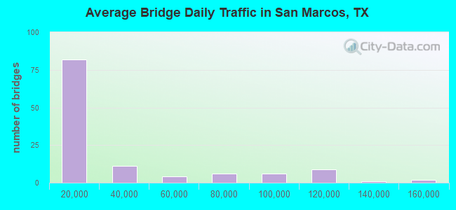
- 3,419,614Total average daily traffic
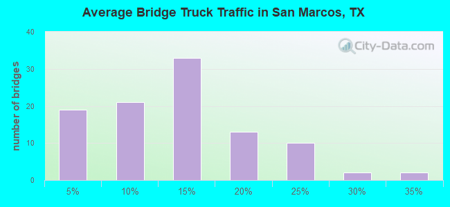
- 476,444Total average daily truck traffic
- National Bridge Inventory (NBI) Registered Bridges for San Marcos
- No street view available for this location
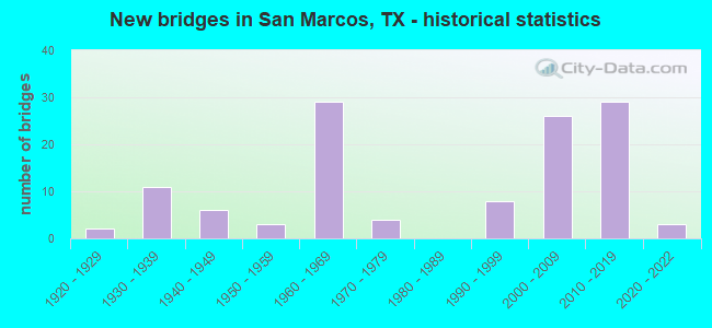
- New bridges - historical statistics
- 21920-1929
- 111930-1939
- 61940-1949
- 31950-1959
- 291960-1969
- 41970-1979
- 81990-1999
- 262000-2009
- 292010-2019
- 32020-2022
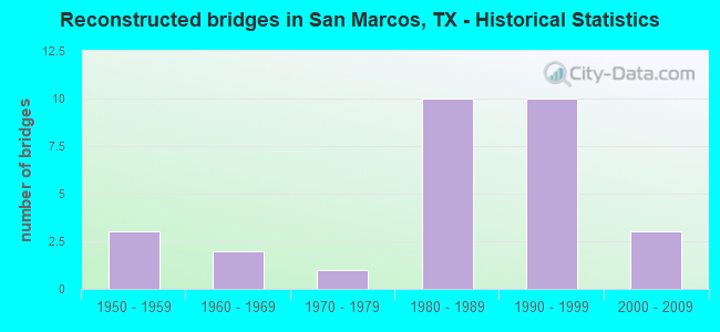
- Reconstructed bridges - Historical Statistics
- 31950-1959
- 21960-1969
- 11970-1979
- 101980-1989
- 101990-1999
- 32000-2009
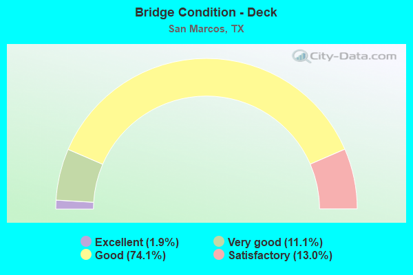
- Bridge Condition - Deck
- 1.9%Excellent
- 11.1%Very good
- 74.1%Good
- 13.0%Satisfactory
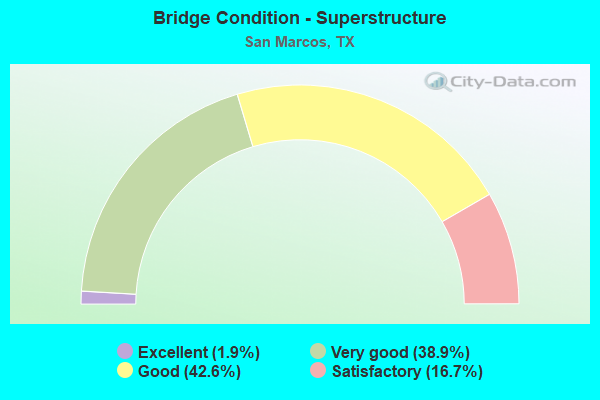
- Bridge Condition - Superstructure
- 1.9%Excellent
- 38.9%Very good
- 42.6%Good
- 16.7%Satisfactory
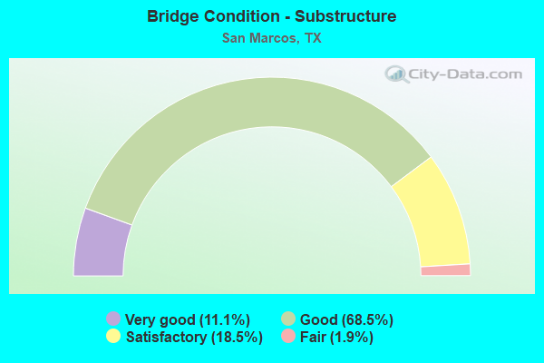
- Bridge Condition - Substructure
- 11.1%Very good
- 68.5%Good
- 18.5%Satisfactory
- 1.9%Fair
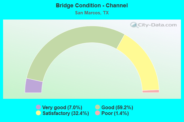
- Bridge Condition - Channel
- 7.0%Very good
- 59.2%Good
- 32.4%Satisfactory
- 1.4%Poor
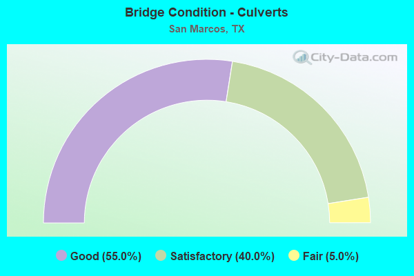
- Bridge Condition - Culverts
- 55.0%Good
- 40.0%Satisfactory
- 5.0%Fair
Find on map >> Show street view
Structure Number: 141060B02000003, Location: 0.01 MI W OF SH 123 (Lat: 29.832986, Lng: -97.942214), Route carried "on" structure: City street , Year Built: 2005, Status: Open, Structure Length: 0.64m (2.10ft), Average Daily Traffic: 1,200 (year 2014), Truck Traffic: 10%, Average Future Daily Traffic: 2,000 (year 2034), Design Load: HS 20, Features Intersected: DRAW, Facility Carried by Structure: CLOVIS BARKER RD
Minimum Vertical Clearance: 30+ m (98+ ft), Kilometerpoint: 0.016, Lanes on structure: 5, Owner: City or Municipal Highway Agency, Approaching Roadway Width: 21.3m (69.9ft), Skew: 3 degrees, Material/Design: Concrete, Design/Construction: Culvert, Number Of Spans In Main Unit: 4, Length of Maximum Span: 1.2m (3.9ft), Curb-To-Curb Width: 21.1m (69.2ft), Out-to-Out Width: 22.7m (74.5ft)
Condition: Channel: Good, Culverts: Good, Operating Rating: 54.4 metric tons, Method Used To Determine Operating Rating: Assigned rating based on Load Factor Design (LFD) reported in metric tons, Inventory Rating: 32.7 metric tons, Method Used To Determine Inventory Rating: Assigned rating based on Load Factor Design (LFD) reported in metric tons, Structural Evaluation: Better than present minimum criteria, Deck Geometry: Somewhat better than minimum adequacy, Waterway Adequacy: Better than present minimum criteria, Approach Roadway Alignment: Equal to present desirable criteria, Designated Inspection Frequency: Every 24 months, Inspection Date: April 2020, Deck Structure Type: Concrete Precast Panels, Wearing Surface/Protective System: Wearing Surface: Bituminous
Find on map >> Show street view
Structure Number: 141060B02000004, Location: 0.4 MI SE of SH 123 (Lat: 29.817806, Lng: -97.939778), Route carried "on" structure: City street , Year Built: 2020, Status: Open, Structure Length: 1.07m (3.51ft), Average Daily Traffic: 3,124 (year 2019), Truck Traffic: 3%, Average Future Daily Traffic: 4,374 (year 2039), Design Load: HL 93, Features Intersected: COTTONWOOD CRK TRIB, Facility Carried by Structure: MONTERREY OAK
Minimum Vertical Clearance: 30+ m (98+ ft), Kilometerpoint: 0.644, Lanes on structure: 2, Owner: City or Municipal Highway Agency, Approaching Roadway Width: 11.0m (36.1ft), Skew: 3 degrees, Material/Design: Concrete, Design/Construction: Culvert, Number Of Spans In Main Unit: 4, Length of Maximum Span: 2.4m (7.9ft), Curb or Sidewalk Widths: Left: 1.5m (4.9ft), Right: 1.5m (4.9ft), Curb-To-Curb Width: 10.9m (35.8ft), Out-to-Out Width: 19.5m (64.0ft)
Condition: Channel: Very good, Culverts: Good, Operating Rating: 54.4 metric tons, Method Used To Determine Operating Rating: Assigned ratings based on Load and Resistance Factor Design (LRFD) reported in metric tons, Inventory Rating: 32.7 metric tons, Method Used To Determine Inventory Rating: Assigned ratings based on Load and Resistance Factor Design (LRFD) reported in metric tons, Structural Evaluation: Better than present minimum criteria, Deck Geometry: Somewhat better than minimum adequacy, Waterway Adequacy: Superior to present desirable criteria, Approach Roadway Alignment: Equal to present desirable criteria, Designated Inspection Frequency: Every 24 months, Inspection Date: December 2020, Deck Structure Type: Concrete Cast-file-Place, Wearing Surface/Protective System: Wearing Surface: Bituminous
Find on map >> Show street view
Structure Number: 150460001604011, Location: 0.5 MI SW OF FM 1102 (Lat: 29.787586, Lng: -98.028497), Route carried "on" structure: Interstate 35, Year Built: 1933, Year Reconstructed: 1994, Status: Open, Structure Length: 1.37m (4.49ft), Average Daily Traffic: 112,918 (year 2020), Truck Traffic: 20%, Average Future Daily Traffic: 106,840 (year 2033), Design Load: H 15, Features Intersected: CANEY CREEK
Minimum Vertical Clearance: 30+ m (98+ ft), Kilometerpoint: 30.800, Lanes on structure: 10, Owner: State Highway Agency, Approaching Roadway Width: 59.1m (193.9ft), Skew: 10 degrees, Material/Design: Concrete, Design/Construction: Culvert, Number Of Spans In Main Unit: 7, Length of Maximum Span: 1.8m (5.9ft)
Condition: Channel: Satisfactory, Culverts: Satisfactory, Operating Rating: 39.9 metric tons, Method Used To Determine Operating Rating: Load Factor (LF), Inventory Rating: 23.6 metric tons, Method Used To Determine Inventory Rating: Load Factor (LF), Structural Evaluation: Somewhat better than minimum adequacy, Waterway Adequacy: Equal to present minimum criteria, Approach Roadway Alignment: Equal to present desirable criteria, Length Of Structure Improvement: 1.43m (4.69ft), Designated Inspection Frequency: Every 24 months, Inspection Date: June 2020, Bridge Improvement Cost: $53,000, Roadway Improvement Cost: $13,000, Total Project Cost: $66,000
Find on map >> Show street view
Structure Number: 150460001604056, Location: 0.2 MI N OF FM 1102 (Lat: 29.794775, Lng: -98.021578), Route carried "on" structure: Interstate 35, Year Built: 1965, Year Reconstructed: 1994, Status: Open, Structure Length: 0.91m (2.99ft), Average Daily Traffic: 93,000 (year 2020), Truck Traffic: 20%, Average Future Daily Traffic: 108,800 (year 2033), Design Load: HS 20, Features Intersected: YORK CREEK BRANCH
Minimum Vertical Clearance: 30+ m (98+ ft), Kilometerpoint: 31.839, Lanes on structure: 10, Owner: State Highway Agency, Approaching Roadway Width: 59.1m (193.9ft), Skew: 9 degrees, Material/Design: Concrete, Design/Construction: Culvert, Number Of Spans In Main Unit: 2, Length of Maximum Span: 3.0m (9.8ft)
Condition: Channel: Satisfactory, Culverts: Satisfactory, Operating Rating: 39.9 metric tons, Method Used To Determine Operating Rating: Load Factor (LF), Inventory Rating: 23.6 metric tons, Method Used To Determine Inventory Rating: Load Factor (LF), Structural Evaluation: Somewhat better than minimum adequacy, Waterway Adequacy: Equal to present minimum criteria, Approach Roadway Alignment: Equal to present desirable criteria, Designated Inspection Frequency: Every 24 months, Inspection Date: June 2020
Find on map >> Show street view
Structure Number: 150460001604057, Location: 0.1 MI N OF FM 1102 (Lat: 29.792092, Lng: -98.023897), Route carried "on" structure: Interstate 35, Year Built: 1957, Year Reconstructed: 1994, Status: Open, Structure Length: 6.10m (20.01ft), Average Daily Traffic: 63,085 (year 2019), Truck Traffic: 20%, Average Future Daily Traffic: 53,420 (year 2033), Design Load: H 15, Features Intersected: YORK CREEK
Minimum Vertical Clearance: 30+ m (98+ ft), Kilometerpoint: 31.426, Lanes on structure: 3, Owner: State Highway Agency, Approaching Roadway Width: 17.1m (56.1ft), Material/Design: Concrete continuous, Design/Construction: Slab, Number Of Spans In Main Unit: 8, Length of Maximum Span: 7.6m (24.9ft), Curb-To-Curb Width: 17.1m (56.1ft), Out-to-Out Width: 17.7m (58.1ft)
Condition: Deck: Satisfactory, Superstructure: Satisfactory, Substructure: Good, Channel: Satisfactory, Operating Rating: 41.7 metric tons, Method Used To Determine Operating Rating: Load Factor (LF), Inventory Rating: 24.5 metric tons, Method Used To Determine Inventory Rating: Load Factor (LF), Structural Evaluation: Equal to present minimum criteria, Deck Geometry: Equal to present minimum criteria, Waterway Adequacy: Superior to present desirable criteria, Approach Roadway Alignment: Equal to present desirable criteria, Designated Inspection Frequency: Every 24 months, Inspection Date: June 2020, Deck Structure Type: Concrete Cast-file-Place, Wearing Surface/Protective System: Wearing Surface: Bituminous
Find on map >> Show street view
Structure Number: 150460001604144, Location: 8.0 MI N OF SH 46 (Lat: 29.793861, Lng: -98.022769), Route carried "on" structure: State highway 1102, Year Built: 1965, Year Reconstructed: 1994, Status: Open, Structure Length: 13.62m (44.69ft), Average Daily Traffic: 2,730 (year 2013), Truck Traffic: 16%, Average Future Daily Traffic: 3,820 (year 2033), Design Load: H 20, Features Intersected: IH 35 ML & FR
Minimum Vertical Clearance: 30+ m (98+ ft), Kilometerpoint: 8.047, Lanes on structure: 2, Lanes under structure: 10, Owner: State Highway Agency, Approaching Roadway Width: 12.2m (40.0ft), Skew: 1 degrees, Material/Design: Prestressed concrete, Design/Construction: Stringer/Multi-beam, Number Of Spans In Main Unit: 6, Number Of Approach Spans: 2, Length of Maximum Span: 19.8m (65.0ft), Curb-To-Curb Width: 11.9m (39.0ft), Out-to-Out Width: 13.0m (42.7ft)
Condition: Deck: Good, Superstructure: Satisfactory, Substructure: Good, Operating Rating: 59.9 metric tons, Method Used To Determine Operating Rating: Load Factor (LF), Inventory Rating: 34.5 metric tons, Method Used To Determine Inventory Rating: Load Factor (LF), Structural Evaluation: Equal to present minimum criteria, Deck Geometry: Somewhat better than minimum adequacy, Underclear: High priority of corrective action, Approach Roadway Alignment: Equal to present desirable criteria, Designated Inspection Frequency: Every 24 months, Inspection Date: June 2020, Deck Structure Type: Concrete Cast-file-Place, Wearing Surface/Protective System: Wearing Surface: Bituminous
Find on map >> Show street view
Structure Number: 150460001604145, Location: 0.1 MI S OF FM 1102 (Lat: 29.792497, Lng: -98.024400), Route carried "on" structure: ServiceInterstate 35, Year Built: 1965, Year Reconstructed: 1995, Status: Open, Structure Length: 3.11m (10.20ft), Average Daily Traffic: 2,757 (year 2020), Truck Traffic: 20%, Average Future Daily Traffic: 2,040 (year 2033), Design Load: H 20, Features Intersected: YORK CREEK
Minimum Vertical Clearance: 30+ m (98+ ft), Kilometerpoint: 31.437, Lanes on structure: 2, Owner: State Highway Agency, Approaching Roadway Width: 11.0m (36.1ft), Skew: 3 degrees, Material/Design: Concrete, Design/Construction: Slab, Number Of Spans In Main Unit: 4, Length of Maximum Span: 7.9m (25.9ft), Curb-To-Curb Width: 11.1m (36.4ft), Out-to-Out Width: 11.7m (38.4ft)
Condition: Deck: Good, Superstructure: Good, Substructure: Satisfactory, Channel: Satisfactory, Operating Rating: 45.4 metric tons, Method Used To Determine Operating Rating: Load Factor (LF), Inventory Rating: 27.2 metric tons, Method Used To Determine Inventory Rating: Load Factor (LF), Structural Evaluation: Equal to present minimum criteria, Deck Geometry: Somewhat better than minimum adequacy, Waterway Adequacy: Better than present minimum criteria, Approach Roadway Alignment: Equal to present desirable criteria, Designated Inspection Frequency: Every 24 months, Inspection Date: June 2020, Deck Structure Type: Concrete Cast-file-Place, Wearing Surface/Protective System: Wearing Surface: Bituminous
Find on map >> Show street view
Structure Number: 150460001604146, Location: 0.1 MI S OF FM 1102 (Lat: 29.791931, Lng: -98.023803), Route carried "on" structure: ServiceInterstate 35, Year Built: 1965, Year Reconstructed: 1995, Status: Open, Structure Length: 3.05m (10.01ft), Average Daily Traffic: 3,857 (year 2020), Average Future Daily Traffic: 1,660 (year 2033), Design Load: H 20, Features Intersected: YORK CREEK
Minimum Vertical Clearance: 30+ m (98+ ft), Kilometerpoint: 31.437, Lanes on structure: 2, Owner: State Highway Agency, Approaching Roadway Width: 9.8m (32.2ft), Material/Design: Concrete, Design/Construction: Slab, Number Of Spans In Main Unit: 4, Length of Maximum Span: 7.6m (24.9ft), Curb-To-Curb Width: 11.1m (36.4ft), Out-to-Out Width: 11.6m (38.1ft)
Condition: Deck: Good, Superstructure: Good, Substructure: Satisfactory, Channel: Satisfactory, Operating Rating: 48.1 metric tons, Method Used To Determine Operating Rating: Load Factor (LF), Inventory Rating: 29.0 metric tons, Method Used To Determine Inventory Rating: Load Factor (LF), Structural Evaluation: Equal to present minimum criteria, Deck Geometry: Somewhat better than minimum adequacy, Waterway Adequacy: Better than present minimum criteria, Approach Roadway Alignment: Equal to present desirable criteria, Length Of Structure Improvement: 3.05m (10.01ft), Designated Inspection Frequency: Every 24 months, Inspection Date: June 2020, Bridge Improvement Cost: $228,000, Roadway Improvement Cost: $23,000, Total Project Cost: $342,000, Deck Structure Type: Concrete Cast-file-Place, Wearing Surface/Protective System: Wearing Surface: Bituminous
Find on map >> Show street view
Structure Number: 150460229302002, Location: 6.7 MI NE OF FM 306 (Lat: 29.811906, Lng: -98.019275), Route carried "on" structure: State highway 2439, Year Built: 2009, Status: Open, Structure Length: 1.19m (3.90ft), Average Daily Traffic: 6,911 (year 2020), Truck Traffic: 3%, Average Future Daily Traffic: 13,500 (year 2038), Design Load: HS 20, Features Intersected: DRAW
Minimum Vertical Clearance: 30+ m (98+ ft), Kilometerpoint: 0.848, Lanes on structure: 2, Owner: State Highway Agency, Approaching Roadway Width: 9.8m (32.2ft), Material/Design: Concrete, Design/Construction: Culvert, Number Of Spans In Main Unit: 4, Length of Maximum Span: 2.4m (7.9ft), Curb-To-Curb Width: 9.8m (32.2ft), Out-to-Out Width: 17.7m (58.1ft)
Condition: Channel: Good, Culverts: Good, Operating Rating: 54.4 metric tons, Method Used To Determine Operating Rating: Assigned rating based on Load Factor Design (LFD) reported in metric tons, Inventory Rating: 32.7 metric tons, Method Used To Determine Inventory Rating: Assigned rating based on Load Factor Design (LFD) reported in metric tons, Structural Evaluation: Better than present minimum criteria, Deck Geometry: Meets minimum limits, Waterway Adequacy: Equal to present minimum criteria, Approach Roadway Alignment: Equal to present desirable criteria, Designated Inspection Frequency: Every 24 months, Inspection Date: June 2020, Deck Structure Type: Concrete Cast-file-Place, Wearing Surface/Protective System: Wearing Surface: Bituminous
Find on map >> Show street view
Structure Number: 150460AA2000001, Location: 0.7 MI NE of IH 35 EFR (Lat: 29.788017, Lng: -98.023567), Route carried "on" structure: County highway , Year Built: 1925, Year Reconstructed: 1960, Status: Open, Structure Length: 0.91m (2.99ft), Average Daily Traffic: 100 (year 2010), Truck Traffic: 5%, Average Future Daily Traffic: 101 (year 2030), Features Intersected: CANEY CREEK, Facility Carried by Structure: Old Bastrop Road
Minimum Vertical Clearance: 30+ m (98+ ft), Kilometerpoint: 0.000, Lanes on structure: 2, Owner: County Highway Agency, Approaching Roadway Width: 6.4m (21.0ft), Material/Design: Concrete, Design/Construction: Culvert, Number Of Spans In Main Unit: 3, Length of Maximum Span: 3.0m (9.8ft), Curb-To-Curb Width: 7.2m (23.6ft), Out-to-Out Width: 7.7m (25.3ft)
Condition: Channel: Good, Culverts: Satisfactory, Operating Rating: 32.7 metric tons, Method Used To Determine Operating Rating: Field evaluation and documented engineering judgment, Inventory Rating: 24.5 metric tons, Method Used To Determine Inventory Rating: Field evaluation and documented engineering judgment, Structural Evaluation: Equal to present minimum criteria, Deck Geometry: Somewhat better than minimum adequacy, Waterway Adequacy: Better than present minimum criteria, Approach Roadway Alignment: Equal to present desirable criteria, Designated Inspection Frequency: Every 24 months, Inspection Date: September 2021, Deck Structure Type: Concrete Cast-file-Place, Wearing Surface/Protective System: Wearing Surface: Bituminous
Find on map >> Show street view
Structure Number: 150950127202004, Location: 0.53 MI E. OF COMAL C/L (Lat: 29.745892, Lng: -97.994381), Route carried "on" structure: State highway 1101, Year Built: 1962, Year Reconstructed: 1980, Status: Open, Structure Length: 1.16m (3.81ft), Average Daily Traffic: 2,552 (year 2020), Truck Traffic: 25%, Average Future Daily Traffic: 2,040 (year 2033), Design Load: HS 20, Features Intersected: DRAW
Minimum Vertical Clearance: 30+ m (98+ ft), Kilometerpoint: 0.855, Lanes on structure: 2, Owner: State Highway Agency, Approaching Roadway Width: 8.5m (27.9ft), Material/Design: Concrete, Design/Construction: Culvert, Number Of Spans In Main Unit: 4, Length of Maximum Span: 2.7m (8.9ft)
Condition: Channel: Good, Culverts: Fair, Operating Rating: 39.9 metric tons, Method Used To Determine Operating Rating: Load Factor (LF), Inventory Rating: 23.6 metric tons, Method Used To Determine Inventory Rating: Load Factor (LF), Structural Evaluation: Somewhat better than minimum adequacy, Waterway Adequacy: Equal to present minimum criteria, Approach Roadway Alignment: Equal to present desirable criteria, Length Of Structure Improvement: 1.19m (3.90ft), Designated Inspection Frequency: Every 24 months, Inspection Date: August 2020
Find on map >> Show street view
Structure Number: 141060001602201, Location: 1.6 MI N OF LP 82 (Lat: 29.913128, Lng: -97.897936), Route carried "under" structure: Interstate 35, Year Built: 1935, Structure Length: 0. m, Average Daily Traffic: 86,940 (year 2013), Truck Traffic: 12%, Features Intersected: BLANCO RIVER
Minimum Vertical Clearance: 30+ m (98+ ft), Kilometerpoint: 16.684, Lanes on structure: 6, Material/Design: Prestressed concrete, Design/Construction: Stringer/Multi-beam, Length of Maximum Span: 30.5m (100.1ft)
Find on map >> Show street view
Structure Number: 141060001602226, Location: 0.5 MI S OF BLANCO RIVER (Lat: 29.904894, Lng: -97.902336), Route carried "under" structure: City street , Year Built: 2004, Structure Length: 0. m, Average Daily Traffic: 500 (year 2012), Truck Traffic: 2%, Features Intersected: RIVER RIDGE PARKWAY, Facility Carried by Structure: IH 35 ML
Minimum Vertical Clearance: 5.49m (18.01ft), Kilometerpoint: 0.161, Lanes on structure: 6, Lanes under structure: 7, Material/Design: Prestressed concrete, Design/Construction: Stringer/Multi-beam, Length of Maximum Span: 25.9m (85.0ft)
Find on map >> Show street view
Structure Number: 141060001602231, Location: 5.3 MI S OF RM 150 (Lat: 29.911614, Lng: -97.898050), Route carried "under" structure: ServiceInterstate 35, Year Built: 2004, Structure Length: 0. m, Average Daily Traffic: 20,570 (year 2013), Truck Traffic: 14%, Features Intersected: BLANCO RIVER
Minimum Vertical Clearance: 30+ m (98+ ft), Kilometerpoint: 16.684, Lanes on structure: 2, Material/Design: Prestressed concrete, Design/Construction: Stringer/Multi-beam, Length of Maximum Span: 33.5m (109.9ft)
Find on map >> Show street view
Structure Number: 141060001602232, Location: 5.3 MI S OF RM 150 (Lat: 29.913106, Lng: -97.898397), Route carried "under" structure: ServiceInterstate 35, Year Built: 2004, Structure Length: 0. m, Average Daily Traffic: 5,870 (year 2013), Truck Traffic: 12%, Features Intersected: BLANCO RIVER
Minimum Vertical Clearance: 30+ m (98+ ft), Kilometerpoint: 16.684, Lanes on structure: 2, Material/Design: Prestressed concrete, Design/Construction: Stringer/Multi-beam, Length of Maximum Span: 36.6m (120.1ft)
Find on map >> Show street view
Structure Number: 14106000160245, Location: 3.0 MI S OF FM 150 (Lat: 29.947022, Lng: -97.880686), Route carried "under" structure: Interstate 35, Year Built: 2015, Structure Length: 0. m, Average Daily Traffic: 104,900 (year 2010), Truck Traffic: 15%, Features Intersected: IH 35 ML, Facility Carried by Structure: CR 159(YARRINGTON)
Minimum Vertical Clearance: 5.13m (16.83ft), Kilometerpoint: 20.595, Lanes on structure: 4, Lanes under structure: 6, Material/Design: Prestressed concrete, Design/Construction: Box Beam or Girders - Multiple, Length of Maximum Span: 33.8m (110.9ft)
Find on map >> Show street view
Structure Number: 141060001602451, Location: 3.1 MI S OF FM 150 (Lat: 29.946592, Lng: -97.880217), Route carried "under" structure: Interstate 35, Year Built: 2015, Structure Length: 0. m, Average Daily Traffic: 104,900 (year 2010), Truck Traffic: 15%, Features Intersected: IH 35 ML
Minimum Vertical Clearance: 5.21m (17.09ft), Kilometerpoint: 20.550, Lanes on structure: 1, Lanes under structure: 6, Material/Design: Prestressed concrete, Design/Construction: Box Beam or Girders - Multiple, Length of Maximum Span: 32.0m (105.0ft)
Find on map >> Show street view
Structure Number: 141060001603121, Location: 0.9 MI N OF SH 80 (Lat: 29.892975, Lng: -97.912478), Route carried "under" structure: Business State highway 82, Year Built: 1963, Structure Length: 0. m, Average Daily Traffic: 28,520 (year 2013), Truck Traffic: 19%, Features Intersected: LP 82, Facility Carried by Structure: IH 35 SB ML
Minimum Vertical Clearance: 4.57m (14.99ft), Kilometerpoint: 0.116, Lanes on structure: 3, Lanes under structure: 6, Material/Design: Prestressed concrete, Design/Construction: Stringer/Multi-beam, Length of Maximum Span: 18.3m (60.0ft)
Find on map >> Show street view
Structure Number: 141060001603122, Location: 0.9 MI N OF SH 80 (Lat: 29.892975, Lng: -97.912339), Route carried "under" structure: Business State highway 82, Year Built: 1963, Structure Length: 0. m, Average Daily Traffic: 28,520 (year 2013), Truck Traffic: 19%, Features Intersected: LP 82, Facility Carried by Structure: IH 35 NB ML
Minimum Vertical Clearance: 4.93m (16.17ft), Kilometerpoint: 0.148, Lanes on structure: 3, Lanes under structure: 6, Material/Design: Prestressed concrete, Design/Construction: Stringer/Multi-beam, Length of Maximum Span: 18.3m (60.0ft)
Find on map >> Show street view
Structure Number: 141060001603123, Location: 0.2 MI N OF SH 80 (Lat: 29.884925, Lng: -97.919894), Route carried "under" structure: Interstate 35, Year Built: 1963, Structure Length: 0. m, Average Daily Traffic: 39,760 (year 2013), Truck Traffic: 12%, Features Intersected: UPRR
Minimum Vertical Clearance: 30+ m (98+ ft), Kilometerpoint: 13.047, Lanes on structure: 3, Material/Design: Prestressed concrete, Design/Construction: Stringer/Multi-beam, Length of Maximum Span: 15.2m (49.9ft)
Find on map >> Show street view
Structure Number: 141060001603124, Location: 0.2 MI N OF SH 80 (Lat: 29.884864, Lng: -97.919789), Route carried "under" structure: Interstate 35, Year Built: 1963, Structure Length: 0. m, Average Daily Traffic: 39,760 (year 0000), Truck Traffic: 12%, Features Intersected: UPRR
Minimum Vertical Clearance: 30+ m (98+ ft), Kilometerpoint: 13.047, Lanes on structure: 3, Material/Design: Prestressed concrete, Design/Construction: Stringer/Multi-beam, Length of Maximum Span: 15.2m (49.9ft)
Find on map >> Show street view
Structure Number: 141060001603125, Location: 1.4 MI N OF SH 123 (Lat: 29.882725, Lng: -97.921933), Route carried "under" structure: State highway 80, Year Built: 1963, Structure Length: 0. m, Average Daily Traffic: 35,140 (year 2013), Truck Traffic: 6%, Features Intersected: SH 80, Facility Carried by Structure: IH 35 SB ML
Minimum Vertical Clearance: 4.55m (14.93ft), Kilometerpoint: 0.063, Lanes on structure: 3, Lanes under structure: 7, Material/Design: Prestressed concrete, Design/Construction: Stringer/Multi-beam, Length of Maximum Span: 18.3m (60.0ft)
Find on map >> Show street view
Structure Number: 141060001603126, Location: 1.4 MI N OF SH 123 (Lat: 29.882672, Lng: -97.921856), Route carried "under" structure: State highway 80, Year Built: 1963, Structure Length: 0. m, Average Daily Traffic: 35,140 (year 2013), Truck Traffic: 6%, Features Intersected: SH 80, Facility Carried by Structure: IH 35 NB ML
Minimum Vertical Clearance: 4.47m (14.67ft), Kilometerpoint: 0.109, Lanes on structure: 3, Lanes under structure: 7, Material/Design: Prestressed concrete, Design/Construction: Stringer/Multi-beam, Length of Maximum Span: 18.3m (60.0ft)
Find on map >> Show street view
Structure Number: 141060001603131, Location: 1.4 MI S OF SH 80 (Lat: 29.869442, Lng: -97.939050), Route carried "under" structure: State highway 123, Year Built: 1963, Structure Length: 0. m, Average Daily Traffic: 24,000 (year 2011), Truck Traffic: 6%, Features Intersected: SH 123, Facility Carried by Structure: IH 35 SB ML
Minimum Vertical Clearance: 4.95m (16.24ft), Kilometerpoint: 16.126, Lanes on structure: 3, Lanes under structure: 6, Material/Design: Prestressed concrete, Design/Construction: Stringer/Multi-beam, Length of Maximum Span: 20.4m (66.9ft)
Find on map >> Show street view
Structure Number: 141060001603132, Location: 1.4 MI S OF SH 80 (Lat: 29.869319, Lng: -97.939022), Route carried "under" structure: State highway 123, Year Built: 1963, Structure Length: 0. m, Average Daily Traffic: 24,000 (year 2011), Truck Traffic: 6%, Features Intersected: SH 123, Facility Carried by Structure: IH 35 NB ML
Minimum Vertical Clearance: 4.67m (15.32ft), Kilometerpoint: 16.135, Lanes on structure: 3, Lanes under structure: 6, Material/Design: Prestressed concrete, Design/Construction: Stringer/Multi-beam, Length of Maximum Span: 20.4m (66.9ft)
Find on map >> Show street view
Structure Number: 141060001603133, Location: 0.6 MI N OF SH 123 (Lat: 29.875203, Lng: -97.931844), Route carried "under" structure: ServiceInterstate 35, Year Built: 1941, Structure Length: 0. m, Average Daily Traffic: 6,800 (year 2013), Truck Traffic: 12%, Features Intersected: SAN MARCOS RIVER
Minimum Vertical Clearance: 30+ m (98+ ft), Kilometerpoint: 11.444, Lanes on structure: 2, Material/Design: Steel, Design/Construction: Stringer/Multi-beam, Length of Maximum Span: 15.2m (49.9ft)
Find on map >> Show street view
Structure Number: 141060001603204, Location: 1.2 MI S OF SH 123 (Lat: 29.856583, Lng: -97.953294), Route carried "under" structure: State highway 3407, Year Built: 1996, Structure Length: 0. m, Average Daily Traffic: 14,300 (year 2009), Truck Traffic: 5%, Features Intersected: RM 12, Facility Carried by Structure: IH 35 ML
Minimum Vertical Clearance: 5.33m (17.49ft), Kilometerpoint: 2.972, Lanes on structure: 6, Lanes under structure: 8, Material/Design: Prestressed concrete, Design/Construction: Stringer/Multi-beam, Length of Maximum Span: 27.4m (89.9ft)
Find on map >> Show street view
Structure Number: 141060001603205, Location: 1.7 MI S OF RM 12 (Lat: 29.839331, Lng: -97.972458), Route carried "under" structure: State highway 110, Year Built: 1996, Structure Length: 0. m, Average Daily Traffic: 4,300 (year 2011), Features Intersected: FM 110 / MCCARTY LANE, Facility Carried by Structure: IH 35 ML
Minimum Vertical Clearance: 5.23m (17.16ft), Kilometerpoint: 2.414, Lanes on structure: 6, Lanes under structure: 6, Material/Design: Prestressed concrete, Design/Construction: Stringer/Multi-beam, Length of Maximum Span: 35.1m (115.2ft)
Find on map >> Show street view
Structure Number: 141060001603212, Location: 2.8 MI S OF FM 3407 (Lat: 29.827767, Lng: -97.985514), Route carried "under" structure: County highway 234, Year Built: 2001, Structure Length: 0. m, Average Daily Traffic: 200 (year 2011), Features Intersected: CENTER POINT ROAD, Facility Carried by Structure: IH 35 ML
Minimum Vertical Clearance: 5.18m (16.99ft), Kilometerpoint: 0.805, Lanes on structure: 6, Lanes under structure: 6, Material/Design: Prestressed concrete, Design/Construction: Stringer/Multi-beam, Length of Maximum Span: 31.7m (104.0ft)
Find on map >> Show street view
Structure Number: 141060001603455, Location: 3.8 MI S OF FM 3407 (Lat: 29.817214, Lng: -97.997347), Route carried "under" structure: City street , Year Built: 2020, Structure Length: 0. m, Average Daily Traffic: 5,000 (year 2020), Truck Traffic: 10%, Features Intersected: Posey Rd., Facility Carried by Structure: IH 35 ML
Minimum Vertical Clearance: 5.19m (17.03ft), Kilometerpoint: 2.469, Lanes on structure: 8, Lanes under structure: 8, Material/Design: Prestressed concrete, Design/Construction: Stringer/Multi-beam, Length of Maximum Span: 33.8m (110.9ft)
Find on map >> Show street view
Structure Number: 141060001609442, Location: 0.70 MI W OF IH 35 (Lat: 29.892000, Lng: -97.926889), Route carried "under" structure: City street , Year Built: 2018, Structure Length: 0. m, Average Daily Traffic: 3,000 (year 2018), Truck Traffic: 2%, Features Intersected: POST RD NB, Facility Carried by Structure: LP 82 -AQUA.SPR.DR
Minimum Vertical Clearance: 5.49m (18.01ft), Kilometerpoint: 1.609, Lanes on structure: 4, Lanes under structure: 2, Material/Design: Steel continuous, Design/Construction: Stringer/Multi-beam, Length of Maximum Span: 71.6m (234.9ft)
Find on map >> Show street view
Structure Number: 141060036601193, Location: 1.1 MI SE OF IH 35 (Lat: 29.845875, Lng: -97.940814), Route carried "under" structure: State highway 12, Year Built: 2016, Structure Length: 0. m, Average Daily Traffic: 16,800 (year 2012), Truck Traffic: 11%, Features Intersected: RM12;FM3407;WNR WRLD DR
Minimum Vertical Clearance: 5.26m (17.26ft), Kilometerpoint: 19.064, Lanes on structure: 2, Lanes under structure: 4, Material/Design: Prestressed concrete, Design/Construction: Stringer/Multi-beam, Length of Maximum Span: 36.0m (118.1ft)
Find on map >> Show street view
Structure Number: 141060036601194, Location: 1.0 MI SE OF IH 35 (Lat: 29.846717, Lng: -97.940850), Route carried "under" structure: State highway 12, Year Built: 2016, Structure Length: 0. m, Average Daily Traffic: 16,800 (year 2012), Truck Traffic: 11%, Features Intersected: RM12;FM3407;WNR WRLD DR
Minimum Vertical Clearance: 5.26m (17.26ft), Kilometerpoint: 19.002, Lanes on structure: 2, Lanes under structure: 4, Material/Design: Prestressed concrete, Design/Construction: Stringer/Multi-beam, Length of Maximum Span: 36.0m (118.1ft)
Find on map >> Show street view
Structure Number: 141060047102085, Location: 1.0 MI SE OF IH 35 (Lat: 29.877114, Lng: -97.906078), Route carried "under" structure: State highway 21, Year Built: 2004, Structure Length: 0. m, Average Daily Traffic: 12,676 (year 2019), Truck Traffic: 9%, Features Intersected: SH 21, Facility Carried by Structure: SH 80
Minimum Vertical Clearance: 5.11m (16.77ft), Kilometerpoint: 0.039, Lanes on structure: 4, Lanes under structure: 5, Material/Design: Prestressed concrete, Design/Construction: Stringer/Multi-beam, Length of Maximum Span: 23.8m (78.1ft)
Find on map >> Show street view
Structure Number: 141060337901205, Location: 2.3 MI NW OF FM 2439 (Lat: 29.892492, Lng: -97.982439), Route carried "under" structure: State highway 12, Year Built: 2010, Structure Length: 0. m, Average Daily Traffic: 4,450 (year 0000), Features Intersected: PRIVATE RD (WILLS)
Minimum Vertical Clearance: 30+ m (98+ ft), Kilometerpoint: 13.897, Lanes on structure: 2, Material/Design: Prestressed concrete, Design/Construction: Stringer/Multi-beam, Length of Maximum Span: 30.5m (100.1ft)
Find on map >> Show street view
Structure Number: 141060337901206, Location: 2.3 MI NW OF FM 2439 (Lat: 29.892583, Lng: -97.982169), Route carried "under" structure: State highway 12, Year Built: 2010, Structure Length: 0. m, Average Daily Traffic: 4,450 (year 2011), Features Intersected: PRIVATE RD (WILLS)
Minimum Vertical Clearance: 30+ m (98+ ft), Kilometerpoint: 13.897, Lanes on structure: 2, Material/Design: Prestressed concrete, Design/Construction: Stringer/Multi-beam, Length of Maximum Span: 30.5m (100.1ft)
Find on map >> Show street view
Structure Number: 141060B00209001, Location: 0.30 MI NW OF IH 35 (Lat: 29.950244, Lng: -97.883953), Route carried "under" structure: City street , Year Built: 2008, Structure Length: 0. m, Average Daily Traffic: 500 (year 2014), Truck Traffic: 2%, Features Intersected: UPRR & POST RD, Facility Carried by Structure: YARRINGTON RD
Minimum Vertical Clearance: 8.86m (29.07ft), Kilometerpoint: 0.000, Lanes on structure: 4, Lanes under structure: 2, Material/Design: Prestressed concrete, Design/Construction: Stringer/Multi-beam, Length of Maximum Span: 38.1m (125.0ft)
Find on map >> Show street view
Structure Number: 150460001604144, Location: 8.0 MI N OF SH 46 (Lat: 29.793861, Lng: -98.022769), Route carried "under" structure: Interstate 35, Year Built: 1965, Structure Length: 0. m, Average Daily Traffic: 76,310 (year 2013), Truck Traffic: 20%, Features Intersected: IH 35 ML & FR, Facility Carried by Structure: FM 1102/YORK CK RD
Minimum Vertical Clearance: 5.46m (17.91ft), Kilometerpoint: 31.690, Lanes on structure: 2, Lanes under structure: 10, Material/Design: Prestressed concrete, Design/Construction: Stringer/Multi-beam, Length of Maximum Span: 19.8m (65.0ft)