Bridge Statistics for San Francisco, California (CA)
Condition, Traffic, Stress, Structural Evaluation, Project Costs
- National Bridge Inventory (NBI) Statistics
- 358Number of bridges
- 14,222ft / 4,335mTotal length
- $3,359,000Total costs
- 17,990,574Total average daily traffic
- 561,159Total average daily truck traffic
- National Bridge Inventory (NBI) Registered Bridges for San Francisco
- No street view available for this location
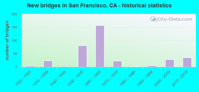
- New bridges - historical statistics
- 11900-1909
- 11910-1919
- 31920-1929
- 231930-1939
- 21940-1949
- 801950-1959
- 1571960-1969
- 221970-1979
- 11980-1989
- 51990-1999
- 282000-2009
- 352010-2019
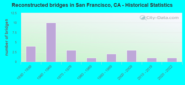
- Reconstructed bridges - Historical Statistics
- 41950-1959
- 101960-1969
- 31970-1979
- 11980-1989
- 21990-1999
- 32000-2009
- 12010-2019
- 12020-2022
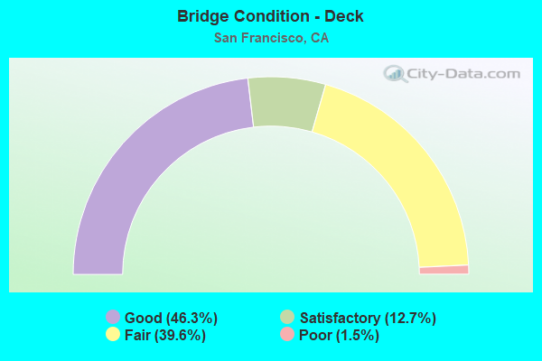
- Bridge Condition - Deck
- 46.3%Good
- 12.7%Satisfactory
- 39.6%Fair
- 1.5%Poor
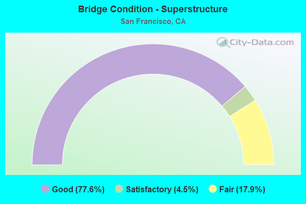
- Bridge Condition - Superstructure
- 77.6%Good
- 4.5%Satisfactory
- 17.9%Fair
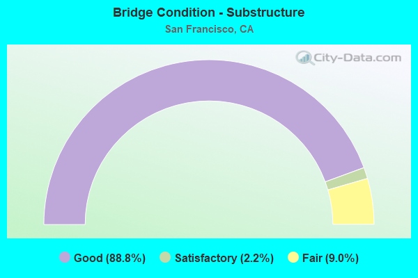
- Bridge Condition - Substructure
- 88.8%Good
- 2.2%Satisfactory
- 9.0%Fair
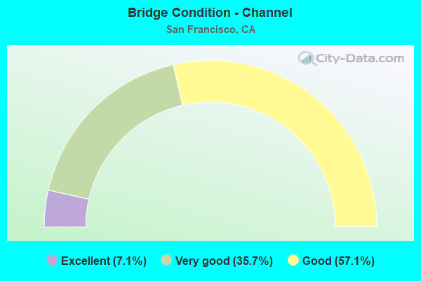
- Bridge Condition - Channel
- 7.1%Excellent
- 35.7%Very good
- 57.1%Good
Find on map >> Show street view
Structure Number: 34 0001, Location: 04-SF-035-2.12-SF (Lat: 37.733722, Lng: -122.494211), Route carried "on" structure: State highway 35, Year Built: 1931, Status: Open, Structure Length: 7.32m (24.02ft), Average Daily Traffic: 23,600 (year 2019), Truck Traffic: 1%, Average Future Daily Traffic: 44,320 (year 2039), Design Load: H 20, Features Intersected: SUNSET BLVD
Minimum Vertical Clearance: 30+ m (98+ ft), Kilometerpoint: 2.120, Lanes on structure: 6, Lanes under structure: 6, Base Highway Network: Yes (, Subroute: 14), Owner: State Highway Agency, Approaching Roadway Width: 26.8m (87.9ft), Skew: 20 degrees, Material/Design: Concrete continuous, Design/Construction: Girder and Floorbeam System, Number Of Spans In Main Unit: 6, Length of Maximum Span: 19.8m (65.0ft), Curb or Sidewalk Widths: Left: 3.6m (11.8ft), Right: 3.6m (11.8ft), Curb-To-Curb Width: 26.8m (87.9ft), Out-to-Out Width: 41.9m (137.5ft)
Condition: Deck: Good, Superstructure: Good, Substructure: Good, Operating Rating: 63.8 metric tons, Method Used To Determine Operating Rating: Load Factor (LF), Inventory Rating: 38.2 metric tons, Method Used To Determine Inventory Rating: Load Factor (LF), Structural Evaluation: Better than present minimum criteria, Deck Geometry: Better than present minimum criteria, Underclear: Meets minimum limits, Approach Roadway Alignment: Equal to present desirable criteria, Designated Inspection Frequency: Every 24 months, Inspection Date: December 2021, Deck Structure Type: Concrete Cast-file-Place, Wearing Surface/Protective System: Wearing Surface: Bituminous
Find on map >> Show street view
Structure Number: 34 0003, Location: 04-SF-080-6.35L-SF (Lat: 37.786425, Lng: -122.390583), Route carried "on" structure: Interstate 80, Year Built: 1936, Year Reconstructed: 1962, Status: Open, Structure Length: 628.13m (2060.79ft), Average Daily Traffic: 248,000 (year 2014), Truck Traffic: 3%, Average Future Daily Traffic: 343,032 (year 2037), Design Load: HS 20, Features Intersected: SAN FRANCISCO BAY, 3 STS
Minimum Vertical Clearance: 4.88m (16.01ft), Kilometerpoint: 6.350, Lanes on structure: 5, Lanes under structure: 24, Base Highway Network: Yes, Toll: Toll bridge, Owner: State Highway Agency, Approaching Roadway Width: 17.7m (58.1ft), Navigation Control: Yes ( Vertical Clearance: 56.4m (185.0ft), Horizontal Clearance: 673.6m (2,210.0ft)), Material/Design: Steel, Design/Construction: Suspension, Number Of Spans In Main Unit: 6, Number Of Approach Spans: 3, Length of Maximum Span: 704.1m (2,310.0ft), Curb or Sidewalk Widths: Left: 0.4m (1.3ft), Right: 0.4m (1.3ft), Curb-To-Curb Width: 17.7m (58.1ft), Out-to-Out Width: 19.1m (62.7ft)
Condition: Deck: Good, Superstructure: Fair, Substructure: Good, Channel: Good, Operating Rating: 51.7 metric tons, Method Used To Determine Operating Rating: Load Factor (LF), Inventory Rating: 30.8 metric tons, Method Used To Determine Inventory Rating: Load Factor (LF), Structural Evaluation: Somewhat better than minimum adequacy, Deck Geometry: High priority of replacement, Underclear: High priority of corrective action, Waterway Adequacy: Better than present minimum criteria, Approach Roadway Alignment: Equal to present minimum criteria, Designated Inspection Frequency: Every 24 months, Critical Feature Inspection Frequency: Every 24 months, Underwater Inspection Frequency: Every 72 months, Inspection Date: November 2020, Critical Feature Inspection Date: November 2021, Underwater Inspection Date: December 2019, Deck Structure Type: Concrete Cast-file-Place, Wearing Surface/Protective System: Wearing Surface: Epoxy Overlay
Find on map >> Show street view
Structure Number: 34 0004F, Location: 04-SF-080-7.85L-SF (Lat: 37.808083, Lng: -122.367278), Route carried "on" structure: Interstate 80, Year Built: 1936, Year Reconstructed: 1962, Status: Open, Structure Length: 8.00m (26.25ft), Average Daily Traffic: 248,000 (year 2014), Truck Traffic: 3%, Average Future Daily Traffic: 343,032 (year 2038), Design Load: HS 20, Features Intersected: YERBA BUENA ISLAND
Minimum Vertical Clearance: 4.88m (16.01ft), Kilometerpoint: 7.850, Lanes on structure: 5, Lanes under structure: 10, Base Highway Network: Yes, Toll: Toll bridge, Owner: State Highway Agency, Approaching Roadway Width: 17.7m (58.1ft), Material/Design: Steel, Design/Construction: Stringer/Multi-beam, Number Of Spans In Main Unit: 8, Length of Maximum Span: 11.0m (36.1ft), Curb or Sidewalk Widths: Left: 0.6m (2.0ft), Right: 1.1m (3.6ft), Curb-To-Curb Width: 17.7m (58.1ft), Out-to-Out Width: 19.4m (63.6ft)
Condition: Deck: Good, Superstructure: Good, Substructure: Good, Operating Rating: 53.5 metric tons, Method Used To Determine Operating Rating: Load Factor (LF), Inventory Rating: 32.6 metric tons, Method Used To Determine Inventory Rating: Load Factor (LF), Structural Evaluation: Better than present minimum criteria, Deck Geometry: High priority of replacement, Approach Roadway Alignment: Equal to present minimum criteria, Designated Inspection Frequency: Every 24 months, Critical Feature Inspection Frequency: Every 24 months, Inspection Date: August 2021, Critical Feature Inspection Date: August 2021, Deck Structure Type: Concrete Cast-file-Place, Wearing Surface/Protective System: Wearing Surface: Other, Membrane: Other
Find on map >> Show street view
Structure Number: 34 0004G, Location: 04-SF-080-7.85L-SF (Lat: 37.810583, Lng: -122.364611), Route carried "on" structure: Interstate 80, Year Built: 2007, Status: Open, Structure Length: 10.63m (34.88ft), Average Daily Traffic: 248,000 (year 2014), Truck Traffic: 3%, Average Future Daily Traffic: 343,032 (year 2038), Design Load: HS 20+Mod, Features Intersected: YERBA BUENA ISLAND
Minimum Vertical Clearance: 4.88m (16.01ft), Kilometerpoint: 7.850, Lanes on structure: 5, Lanes under structure: 10, Base Highway Network: Yes, Toll: Toll bridge, Owner: State Highway Agency, Approaching Roadway Width: 17.7m (58.1ft), Material/Design: Prestressed concrete, Design/Construction: Frame, Number Of Spans In Main Unit: 8, Length of Maximum Span: 23.1m (75.8ft), Curb-To-Curb Width: 17.7m (58.1ft), Out-to-Out Width: 24.0m (78.7ft)
Condition: Deck: Good, Superstructure: Good, Substructure: Good, Operating Rating: 54.1 metric tons, Method Used To Determine Operating Rating: Assigned rating based on Load Factor Design (LFD) reported in metric tons, Inventory Rating: 32.4 metric tons, Method Used To Determine Inventory Rating: Assigned rating based on Load Factor Design (LFD) reported in metric tons, Structural Evaluation: Better than present minimum criteria, Deck Geometry: High priority of replacement, Approach Roadway Alignment: Equal to present minimum criteria, Designated Inspection Frequency: Every 24 months, Inspection Date: August 2021, Deck Structure Type: Concrete Cast-file-Place, Wearing Surface/Protective System: Wearing Surface: Other
Find on map >> Show street view
Structure Number: 34 0006, Location: 04-SF-080-R7.91-SF (Lat: 37.810658, Lng: -122.364283), Route carried "on" structure: Interstate 80, Year Built: 2013, Status: Open, Structure Length: 351.23m (1152.33ft), Average Daily Traffic: 265,000 (year 2016), Truck Traffic: 5%, Average Future Daily Traffic: 343,032 (year 2038), Design Load: HS 20+Mod, Features Intersected: GATE, SAN FRANCISCO BAY
Minimum Vertical Clearance: 4.55m (14.93ft), Kilometerpoint: 7.910, Lanes on structure: 10, Lanes under structure: 6, Base Highway Network: Yes (, Subroute: 1), Toll: Toll bridge, Owner: State Highway Agency, Approaching Roadway Width: 48.0m (157.5ft), Skew: 10 degrees, Navigation Control: Yes ( Vertical Clearance: 43.3m (142.1ft), Horizontal Clearance: 353.8m (1,160.8ft)), Material/Design: Steel continuous, Design/Construction: Suspension, Number Of Spans In Main Unit: 2, Number Of Approach Spans: 60, Length of Maximum Span: 385.0m (1,263.1ft), Curb or Sidewalk Widths: Left: 0.0m, Right: 4.6m (15.1ft), Curb-To-Curb Width: 48.0m (157.5ft), Out-to-Out Width: 77.8m (255.2ft)
Condition: Deck: Good, Superstructure: Good, Substructure: Good, Channel: Excellent, Operating Rating: 54.1 metric tons, Method Used To Determine Operating Rating: Assigned rating based on Load Factor Design (LFD) reported in metric tons, Inventory Rating: 32.4 metric tons, Method Used To Determine Inventory Rating: Assigned rating based on Load Factor Design (LFD) reported in metric tons, Structural Evaluation: Better than present minimum criteria, Deck Geometry: Meets minimum limits, Underclear: High priority of corrective action, Waterway Adequacy: Superior to present desirable criteria, Approach Roadway Alignment: Equal to present desirable criteria, Designated Inspection Frequency: Every 24 months, Critical Feature Inspection Frequency: Every 24 months, Underwater Inspection Frequency: Every 60 months, Inspection Date: September 2021, Critical Feature Inspection Date: May 2020, Underwater Inspection Date: Febuary 2020, Deck Structure Type: Steel plate, Wearing Surface/Protective System: Wearing Surface: Epoxy Overlay
Find on map >> Show street view
Structure Number: 34 0006S, Location: 04-SF-080-R7.98-SF (Lat: 37.811431, Lng: -122.363481), Route carried "on" structure: Ramp Interstate 80, Year Built: 2016, Status: Open, Structure Length: 17.49m (57.38ft), Average Daily Traffic: 3,000 (year 2013), Truck Traffic: 5%, Average Future Daily Traffic: 5,000 (year 2037), Design Load: HS 20+Mod, Features Intersected: SOUTH GATE RD
Minimum Vertical Clearance: 30+ m (98+ ft), Kilometerpoint: 7.980, Lanes on structure: 1, Lanes under structure: 2, Toll: On toll road, Owner: State Highway Agency, Approaching Roadway Width: 7.8m (25.6ft), Material/Design: Prestressed concrete continuous, Design/Construction: Box Beam or Girders - Single/Spread, Number Of Spans In Main Unit: 5, Length of Maximum Span: 39.7m (130.2ft), Curb or Sidewalk Widths: Left: 0.0m, Right: 6.0m (19.7ft), Curb-To-Curb Width: 7.8m (25.6ft), Out-to-Out Width: 14.9m (48.9ft)
Condition: Deck: Good, Superstructure: Good, Substructure: Good, Operating Rating: 54.1 metric tons, Method Used To Determine Operating Rating: Assigned rating based on Load Factor Design (LFD) reported in metric tons, Inventory Rating: 32.4 metric tons, Method Used To Determine Inventory Rating: Assigned rating based on Load Factor Design (LFD) reported in metric tons, Structural Evaluation: Better than present minimum criteria, Deck Geometry: Better than present minimum criteria, Approach Roadway Alignment: Equal to present desirable criteria, Designated Inspection Frequency: Every 24 months, Inspection Date: September 2020, Deck Structure Type: Concrete Cast-file-Place, Wearing Surface/Protective System: Wearing Surface: Integral Concrete
Find on map >> Show street view
Structure Number: 34 0012, Location: 04-SF-280-R3.11-SF (Lat: 37.732189, Lng: -122.428072), Route carried "on" structure: City street D010, Year Built: 1963, Status: Open, Structure Length: 7.16m (23.49ft), Average Daily Traffic: 23,600 (year 2017), Truck Traffic: 1%, Average Future Daily Traffic: 61,785 (year 2040), Design Load: HS 20+Mod, Features Intersected: ROUTE I 280, Facility Carried by Structure: MISSION STREET
Minimum Vertical Clearance: 30+ m (98+ ft), Kilometerpoint: 0.000, Lanes on structure: 4, Lanes under structure: 8, Base Highway Network: Yes, Owner: State Highway Agency, Approaching Roadway Width: 18.0m (59.1ft), Skew: 2 degrees, Material/Design: Concrete continuous, Design/Construction: Box Beam or Girders - Multiple, Number Of Spans In Main Unit: 2, Length of Maximum Span: 38.1m (125.0ft), Curb or Sidewalk Widths: Left: 3.4m (11.2ft), Right: 3.4m (11.2ft), Curb-To-Curb Width: 17.8m (58.4ft), Out-to-Out Width: 25.0m (82.0ft)
Condition: Deck: Good, Superstructure: Good, Substructure: Good, Operating Rating: 60.9 metric tons, Method Used To Determine Operating Rating: Load and Resistance Factor Rating (LRFR) rating reported by rating factor(RF) method using HL-93 loadings, Inventory Rating: 47.0 metric tons, Method Used To Determine Inventory Rating: Load and Resistance Factor Rating (LRFR) rating reported by rating factor(RF) method using HL-93 loadings, Structural Evaluation: Better than present minimum criteria, Deck Geometry: Somewhat better than minimum adequacy, Underclear: Meets minimum limits, Approach Roadway Alignment: Equal to present desirable criteria, Designated Inspection Frequency: Every 24 months, Inspection Date: April 2020, Deck Structure Type: Concrete Cast-file-Place
Find on map >> Show street view
Structure Number: 34 0012Y, Location: 04-SF-280-R3.11-SF (Lat: 37.731675, Lng: -122.428553), Route carried "on" structure: Business City street 280, Year Built: 1951, Status: Open, Structure Length: 5.49m (18.01ft), Average Daily Traffic: 23,000 (year 2018), Truck Traffic: 1%, Average Future Daily Traffic: 59,718 (year 2039), Features Intersected: ALEMANY BLVD, Facility Carried by Structure: MISSION STREET
Minimum Vertical Clearance: 30+ m (98+ ft), Kilometerpoint: 3.110, Lanes on structure: 4, Lanes under structure: 12, Base Highway Network: Yes, Owner: State Highway Agency, Approaching Roadway Width: 17.8m (58.4ft), Skew: 5 degrees, Material/Design: Concrete continuous, Design/Construction: Tee Beam, Number Of Spans In Main Unit: 2, Length of Maximum Span: 27.4m (89.9ft), Curb or Sidewalk Widths: Left: 3.4m (11.2ft), Right: 3.4m (11.2ft), Curb-To-Curb Width: 17.8m (58.4ft), Out-to-Out Width: 25.1m (82.3ft)
Condition: Deck: Good, Superstructure: Good, Substructure: Good, Operating Rating: 54.1 metric tons, Method Used To Determine Operating Rating: Field evaluation and documented engineering judgment, Inventory Rating: 32.4 metric tons, Method Used To Determine Inventory Rating: Field evaluation and documented engineering judgment, Structural Evaluation: Better than present minimum criteria, Deck Geometry: Somewhat better than minimum adequacy, Underclear: High priority of corrective action, Approach Roadway Alignment: Equal to present desirable criteria, Designated Inspection Frequency: Every 48 months, Inspection Date: April 2020, Deck Structure Type: Concrete Cast-file-Place, Wearing Surface/Protective System: Wearing Surface: Bituminous
Find on map >> Show street view
Structure Number: 34 0015, Location: 04-SF-001-6.18-SF (Lat: 37.790456, Lng: -122.470219), Route carried "on" structure: State highway 1, Year Built: 1939, Status: Open, Structure Length: 4.21m (13.81ft), Average Daily Traffic: 64,000 (year 2019), Average Future Daily Traffic: 88,436 (year 2041), Design Load: H 15, Features Intersected: WEST PACIFIC AVE
Minimum Vertical Clearance: 30+ m (98+ ft), Kilometerpoint: 6.180, Lanes on structure: 4, Lanes under structure: 2, Base Highway Network: Yes (, Subroute: 1), Owner: State Highway Agency, Approaching Roadway Width: 17.7m (58.1ft), Skew: 30 degrees, Material/Design: Concrete continuous, Design/Construction: Tee Beam, Number Of Spans In Main Unit: 6, Length of Maximum Span: 10.4m (34.1ft), Curb-To-Curb Width: 13.2m (43.3ft), Out-to-Out Width: 15.4m (50.5ft)
Condition: Deck: Fair, Superstructure: Good, Substructure: Good, Operating Rating: 24.0 metric tons, Method Used To Determine Operating Rating: Load and Resistance Factor Rating (LRFR) rating reported by rating factor(RF) method using HL-93 loadings, Inventory Rating: 18.5 metric tons, Method Used To Determine Inventory Rating: Load and Resistance Factor Rating (LRFR) rating reported by rating factor(RF) method using HL-93 loadings, Structural Evaluation: Meets minimum limits, Deck Geometry: High priority of replacement, Underclear: High priority of corrective action, Approach Roadway Alignment: Equal to present desirable criteria, Designated Inspection Frequency: Every 24 months, Inspection Date: December 2021, Deck Structure Type: Concrete Cast-file-Place
Find on map >> Show street view
Structure Number: 34 0017, Location: 04-SF-001-6.67-SF (Lat: 37.797325, Lng: -122.469397), Route carried "on" structure: State highway 1, Year Built: 1939, Status: Open, Structure Length: 21.58m (70.80ft), Average Daily Traffic: 64,000 (year 2019), Truck Traffic: 2%, Average Future Daily Traffic: 88,436 (year 2041), Design Load: H 15, Features Intersected: KOBBE AVE, HITCHCOCK ST
Minimum Vertical Clearance: 30+ m (98+ ft), Kilometerpoint: 6.670, Lanes on structure: 4, Lanes under structure: 2, Base Highway Network: Yes (, Subroute: 1), Owner: State Highway Agency, Approaching Roadway Width: 13.8m (45.3ft), Skew: 30 degrees, Material/Design: Concrete continuous, Design/Construction: Tee Beam, Number Of Spans In Main Unit: 14, Length of Maximum Span: 16.8m (55.1ft), Curb-To-Curb Width: 13.2m (43.3ft), Out-to-Out Width: 15.4m (50.5ft)
Condition: Deck: Fair, Superstructure: Good, Substructure: Good, Operating Rating: 30.1 metric tons, Method Used To Determine Operating Rating: Load and Resistance Factor Rating (LRFR) rating reported by rating factor(RF) method using HL-93 loadings, Inventory Rating: 23.3 metric tons, Method Used To Determine Inventory Rating: Load and Resistance Factor Rating (LRFR) rating reported by rating factor(RF) method using HL-93 loadings, Structural Evaluation: Somewhat better than minimum adequacy, Deck Geometry: High priority of replacement, Underclear: Meets minimum limits, Approach Roadway Alignment: Equal to present desirable criteria, Designated Inspection Frequency: Every 24 months, Inspection Date: December 2021, Deck Structure Type: Concrete Cast-file-Place
Find on map >> Show street view
Structure Number: 34 0021, Location: 04-SF-001-R0.11-SF (Lat: 37.709544, Lng: -122.471339), Route carried "on" structure: City street , Year Built: 1950, Year Reconstructed: 1966, Status: Open, Structure Length: 30.14m (98.88ft), Average Daily Traffic: 12,666 (year 2019), Truck Traffic: 2%, Average Future Daily Traffic: 18,547 (year 2041), Design Load: H 15, Features Intersected: STATE RTE 1 (SPANS 4&5), Facility Carried by Structure: ALEMANY BLVD
Minimum Vertical Clearance: 30+ m (98+ ft), Kilometerpoint: 0.000, Lanes on structure: 1, Lanes under structure: 6, Base Highway Network: Yes, Owner: State Highway Agency, Approaching Roadway Width: 7.3m (24.0ft), Skew: 5 degrees, Material/Design: Concrete continuous, Design/Construction: Girder and Floorbeam System, Number Of Spans In Main Unit: 12, Length of Maximum Span: 24.1m (79.1ft), Curb or Sidewalk Widths: Left: 0.6m (2.0ft), Right: 1.2m (3.9ft), Curb-To-Curb Width: 7.5m (24.6ft), Out-to-Out Width: 9.9m (32.5ft)
Condition: Deck: Satisfactory, Superstructure: Good, Substructure: Good, Operating Rating: 35.3 metric tons, Method Used To Determine Operating Rating: Load Factor (LF), Inventory Rating: 21.4 metric tons, Method Used To Determine Inventory Rating: Load Factor (LF), Structural Evaluation: Somewhat better than minimum adequacy, Deck Geometry: High priority of replacement, Underclear: Meets minimum limits, Approach Roadway Alignment: Equal to present desirable criteria, Designated Inspection Frequency: Every 24 months, Inspection Date: December 2021, Deck Structure Type: Concrete Cast-file-Place
Find on map >> Show street view
Structure Number: 34 0022, Location: 04-SF-001-4.45-SF (Lat: 37.770636, Lng: -122.479033), Route carried "on" structure: State highway 1, Year Built: 1936, Status: Open, Structure Length: 3.81m (12.50ft), Average Daily Traffic: 81,000 (year 2019), Truck Traffic: 1%, Average Future Daily Traffic: 116,073 (year 2039), Design Load: H 20, Features Intersected: JFK DRIVE
Minimum Vertical Clearance: 30+ m (98+ ft), Kilometerpoint: 4.450, Lanes on structure: 6, Lanes under structure: 2, Base Highway Network: Yes (, Subroute: 1), Owner: State Highway Agency, Approaching Roadway Width: 20.1m (65.9ft), Skew: 20 degrees, Material/Design: Concrete continuous, Design/Construction: Tee Beam, Number Of Spans In Main Unit: 3, Length of Maximum Span: 18.3m (60.0ft), Curb or Sidewalk Widths: Left: 1.4m (4.6ft), Right: 1.4m (4.6ft), Curb-To-Curb Width: 18.2m (59.7ft), Out-to-Out Width: 24.8m (81.4ft)
Condition: Deck: Good, Superstructure: Good, Substructure: Good, Operating Rating: 37.3 metric tons, Method Used To Determine Operating Rating: Load and Resistance Factor Rating (LRFR) rating reported by rating factor(RF) method using HL-93 loadings, Inventory Rating: 28.5 metric tons, Method Used To Determine Inventory Rating: Load and Resistance Factor Rating (LRFR) rating reported by rating factor(RF) method using HL-93 loadings, Structural Evaluation: Better than present minimum criteria, Deck Geometry: High priority of replacement, Underclear: High priority of corrective action, Approach Roadway Alignment: Equal to present desirable criteria, Designated Inspection Frequency: Every 24 months, Inspection Date: December 2021, Deck Structure Type: Concrete Cast-file-Place, Wearing Surface/Protective System: Wearing Surface: Bituminous
Find on map >> Show street view
Structure Number: 34 0026, Location: 04-SF-280-R0.46-SF (Lat: 37.710322, Lng: -122.461125), Route carried "on" structure: Interstate 280, Year Built: 1966, Year Reconstructed: 1972, Status: Open, Structure Length: 11.31m (37.11ft), Average Daily Traffic: 132,000 (year 2014), Truck Traffic: 2%, Average Future Daily Traffic: 171,959 (year 2040), Design Load: HS 20+Mod, Features Intersected: ALEMANY BLVD
Minimum Vertical Clearance: 30+ m (98+ ft), Kilometerpoint: 0.460, Lanes on structure: 8, Lanes under structure: 6, Base Highway Network: Yes (Inventory Route: 2, Subroute: 1), Owner: State Highway Agency, Approaching Roadway Width: 17.1m (56.1ft), Skew: 26 degrees, Material/Design: Concrete continuous, Design/Construction: Box Beam or Girders - Multiple, Number Of Spans In Main Unit: 4, Length of Maximum Span: 33.2m (108.9ft), Curb-To-Curb Width: 40.2m (131.9ft), Out-to-Out Width: 41.6m (136.5ft)
Condition: Deck: Fair, Superstructure: Good, Substructure: Good, Operating Rating: 63.5 metric tons, Method Used To Determine Operating Rating: Load Factor (LF), Inventory Rating: 38.2 metric tons, Method Used To Determine Inventory Rating: Load Factor (LF), Structural Evaluation: Better than present minimum criteria, Deck Geometry: Superior to present desirable criteria, Underclear: Equal to present minimum criteria, Approach Roadway Alignment: Equal to present desirable criteria, Length Of Structure Improvement: 11.31m (37.11ft), Designated Inspection Frequency: Every 24 months, Inspection Date: April 2020, Deck Structure Type: Concrete Cast-file-Place
Find on map >> Show street view
Structure Number: 34 003, Location: 04-SF-101-0.77-SF (Lat: 37.719128, Lng: -122.399328), Route carried "on" structure: US 101, Year Built: 1954, Year Reconstructed: 1970, Status: Open, Structure Length: 8.23m (27.00ft), Average Daily Traffic: 189,000 (year 2018), Truck Traffic: 5%, Average Future Daily Traffic: 236,723 (year 2040), Design Load: HS 20, Features Intersected: 3RD STREET
Minimum Vertical Clearance: 30+ m (98+ ft), Kilometerpoint: 0.770, Lanes on structure: 10, Lanes under structure: 2, Base Highway Network: Yes (Inventory Route: 1, Subroute: 1), Owner: State Highway Agency, Approaching Roadway Width: 46.9m (153.9ft), Skew: 39 degrees, Material/Design: Concrete continuous, Design/Construction: Box Beam or Girders - Multiple, Number Of Spans In Main Unit: 3, Length of Maximum Span: 40.3m (132.2ft), Curb-To-Curb Width: 43.4m (142.4ft), Out-to-Out Width: 47.6m (156.2ft)
Condition: Deck: Satisfactory, Superstructure: Satisfactory, Substructure: Good, Operating Rating: 73.2 metric tons, Method Used To Determine Operating Rating: Load Factor (LF), Inventory Rating: 32.4 metric tons, Method Used To Determine Inventory Rating: Load Factor (LF), Structural Evaluation: Equal to present minimum criteria, Deck Geometry: Better than present minimum criteria, Underclear: Meets minimum limits, Approach Roadway Alignment: Equal to present desirable criteria, Designated Inspection Frequency: Every 24 months, Inspection Date: January 2022, Deck Structure Type: Concrete Cast-file-Place
Find on map >> Show street view
Structure Number: 34 0030S, Location: 04-SF-101-0.77-SF (Lat: 37.719450, Lng: -122.399017), Route carried "on" structure: Bypass US 101, Year Built: 1955, Status: Open, Structure Length: 3.93m (12.89ft), Average Daily Traffic: 32,500 (year 2018), Truck Traffic: 1%, Average Future Daily Traffic: 42,048 (year 2040), Design Load: HS 20, Features Intersected: 3RD STREET
Minimum Vertical Clearance: 30+ m (98+ ft), Kilometerpoint: 0.770, Lanes on structure: 2, Lanes under structure: 2, Base Highway Network: Yes (Inventory Route: 1, Subroute: 1), Owner: State Highway Agency, Approaching Roadway Width: 8.5m (27.9ft), Skew: 1 degrees, Material/Design: Concrete continuous, Design/Construction: Box Beam or Girders - Multiple, Number Of Spans In Main Unit: 3, Length of Maximum Span: 14.0m (45.9ft), Curb or Sidewalk Widths: Left: 0.6m (2.0ft), Right: 1.8m (5.9ft), Curb-To-Curb Width: 8.5m (27.9ft), Out-to-Out Width: 11.5m (37.7ft)
Condition: Deck: Satisfactory, Superstructure: Good, Substructure: Good, Operating Rating: 26.6 metric tons, Method Used To Determine Operating Rating: Load and Resistance Factor Rating (LRFR) rating reported by rating factor(RF) method using HL-93 loadings, Inventory Rating: 18.8 metric tons, Method Used To Determine Inventory Rating: Load and Resistance Factor Rating (LRFR) rating reported by rating factor(RF) method using HL-93 loadings, Structural Evaluation: Meets minimum limits, Deck Geometry: High priority of replacement, Underclear: High priority of corrective action, Approach Roadway Alignment: Equal to present desirable criteria, Designated Inspection Frequency: Every 24 months, Inspection Date: January 2022, Deck Structure Type: Concrete Cast-file-Place
Find on map >> Show street view
Structure Number: 34 0032, Location: 04-SF-101-1.77-SF (Lat: 37.732464, Lng: -122.405433), Route carried "on" structure: City street D038, Year Built: 1954, Status: Open, Structure Length: 4.82m (15.81ft), Average Daily Traffic: 9,281 (year 2018), Truck Traffic: 1%, Average Future Daily Traffic: 27,821 (year 2040), Design Load: HS 20, Features Intersected: ROUTE 101, Facility Carried by Structure: SILVER AVE
Minimum Vertical Clearance: 30+ m (98+ ft), Kilometerpoint: 0.000, Lanes on structure: 4, Lanes under structure: 7, Base Highway Network: Yes, Owner: State Highway Agency, Approaching Roadway Width: 17.1m (56.1ft), Skew: 1 degrees, Material/Design: Concrete continuous, Design/Construction: Box Beam or Girders - Multiple, Number Of Spans In Main Unit: 2, Length of Maximum Span: 23.4m (76.8ft), Curb or Sidewalk Widths: Left: 1.8m (5.9ft), Right: 1.8m (5.9ft), Curb-To-Curb Width: 15.8m (51.8ft), Out-to-Out Width: 21.2m (69.6ft)
Condition: Deck: Satisfactory, Superstructure: Fair, Substructure: Good, Operating Rating: 42.1 metric tons, Method Used To Determine Operating Rating: Load and Resistance Factor Rating (LRFR) rating reported by rating factor(RF) method using HL-93 loadings, Inventory Rating: 30.8 metric tons, Method Used To Determine Inventory Rating: Load and Resistance Factor Rating (LRFR) rating reported by rating factor(RF) method using HL-93 loadings, Structural Evaluation: Somewhat better than minimum adequacy, Deck Geometry: Meets minimum limits, Underclear: Meets minimum limits, Approach Roadway Alignment: Equal to present desirable criteria, Designated Inspection Frequency: Every 24 months, Inspection Date: January 2022, Deck Structure Type: Concrete Cast-file-Place
Find on map >> Show street view
Structure Number: 34 0033, Location: 04-SF-101-2.03-SF (Lat: 37.736047, Lng: -122.407117), Route carried "on" structure: US 101, Year Built: 1950, Year Reconstructed: 2020, Status: Open, Structure Length: 23.10m (75.79ft), Average Daily Traffic: 234,000 (year 2018), Truck Traffic: 3%, Average Future Daily Traffic: 300,008 (year 2040), Design Load: HS 20, Features Intersected: 280/101 IC - ALEMANY CIR
Minimum Vertical Clearance: 6.35m (20.83ft), Kilometerpoint: 2.030, Lanes on structure: 6, Lanes under structure: 9, Base Highway Network: Yes (Inventory Route: 1, Subroute: 1), Owner: State Highway Agency, Approaching Roadway Width: 25.0m (82.0ft), Skew: 23 degrees, Material/Design: Steel, Design/Construction: Stringer/Multi-beam, Number Of Spans In Main Unit: 13, Length of Maximum Span: 22.3m (73.2ft), Curb-To-Curb Width: 23.2m (76.1ft), Out-to-Out Width: 26.8m (87.9ft)
Condition: Deck: Good, Superstructure: Fair, Substructure: Good, Operating Rating: 55.7 metric tons, Method Used To Determine Operating Rating: Load and Resistance Factor Rating (LRFR) rating reported by rating factor(RF) method using HL-93 loadings, Inventory Rating: 42.8 metric tons, Method Used To Determine Inventory Rating: Load and Resistance Factor Rating (LRFR) rating reported by rating factor(RF) method using HL-93 loadings, Structural Evaluation: Somewhat better than minimum adequacy, Deck Geometry: Meets minimum limits, Underclear: High priority of corrective action, Approach Roadway Alignment: Equal to present desirable criteria, Designated Inspection Frequency: Every 24 months, Other Special Inspection Frequency: Every 48 months, Inspection Date: January 2022, Other Special Inspection Date: November 2020, Deck Structure Type: Concrete Cast-file-Place
Find on map >> Show street view
Structure Number: 34 0034, Location: 04-SF-101-2.92-SF (Lat: 37.748014, Lng: -122.403964), Route carried "on" structure: US 101, Year Built: 1951, Year Reconstructed: 1968, Status: Open, Structure Length: 19.05m (62.50ft), Average Daily Traffic: 234,000 (year 2019), Truck Traffic: 3%, Average Future Daily Traffic: 306,058 (year 2040), Design Load: HS 20, Features Intersected: CESAR CHAVEZ BLVD
Minimum Vertical Clearance: 30+ m (98+ ft), Kilometerpoint: 2.920, Lanes on structure: 8, Lanes under structure: 10, Base Highway Network: Yes (Inventory Route: 1, Subroute: 1), Owner: State Highway Agency, Approaching Roadway Width: 36.0m (118.1ft), Skew: 39 degrees, Material/Design: Steel, Design/Construction: Stringer/Multi-beam, Number Of Spans In Main Unit: 10, Length of Maximum Span: 29.3m (96.1ft), Curb-To-Curb Width: 36.0m (118.1ft), Out-to-Out Width: 36.7m (120.4ft)
Condition: Deck: Fair, Superstructure: Good, Substructure: Good, Operating Rating: 57.1 metric tons, Method Used To Determine Operating Rating: Allowable Stress (AS), Inventory Rating: 39.0 metric tons, Method Used To Determine Inventory Rating: Allowable Stress (AS), Structural Evaluation: Better than present minimum criteria, Deck Geometry: Better than present minimum criteria, Underclear: High priority of corrective action, Approach Roadway Alignment: Equal to present desirable criteria, Designated Inspection Frequency: Every 24 months, Critical Feature Inspection Frequency: Every 24 months, Inspection Date: January 2022, Critical Feature Inspection Date: November 2021, Deck Structure Type: Concrete Cast-file-Place
Find on map >> Show street view
Structure Number: 34 0034S, Location: 04-SF-101-2.95-SF (Lat: 37.748594, Lng: -122.403436), Route carried "on" structure: Bypass US 101, Year Built: 1974, Status: Open, Structure Length: 22.80m (74.80ft), Average Daily Traffic: 12,600 (year 2018), Truck Traffic: 3%, Average Future Daily Traffic: 25,823 (year 2042), Design Load: HS 20, Features Intersected: CESAR CHAVEZ BLVD
Minimum Vertical Clearance: 30+ m (98+ ft), Kilometerpoint: 2.950, Lanes on structure: 1, Lanes under structure: 6, Base Highway Network: Yes (Inventory Route: 1, Subroute: 1), Owner: State Highway Agency, Approaching Roadway Width: 6.1m (20.0ft), Material/Design: Concrete continuous, Design/Construction: Box Beam or Girders - Multiple, Number Of Spans In Main Unit: 7, Length of Maximum Span: 42.7m (140.1ft), Curb or Sidewalk Widths: Left: 0.6m (2.0ft), Right: 0.6m (2.0ft), Curb-To-Curb Width: 6.1m (20.0ft), Out-to-Out Width: 7.9m (25.9ft)
Condition: Deck: Fair, Superstructure: Good, Substructure: Good, Operating Rating: 99.8 metric tons, Method Used To Determine Operating Rating: Load Factor (LF), Inventory Rating: 64.2 metric tons, Method Used To Determine Inventory Rating: Load Factor (LF), Structural Evaluation: Better than present minimum criteria, Deck Geometry: High priority of replacement, Underclear: Equal to present minimum criteria, Approach Roadway Alignment: Equal to present desirable criteria, Designated Inspection Frequency: Every 24 months, Inspection Date: January 2022, Deck Structure Type: Concrete Cast-file-Place
Find on map >> Show street view
Structure Number: 34 0035, Location: 04-SF-101-3.37-SF (Lat: 37.754431, Lng: -122.403275), Route carried "on" structure: City street D187, Year Built: 1953, Status: Open, Structure Length: 3.90m (12.80ft), Average Daily Traffic: 4,513 (year 2018), Truck Traffic: 1%, Average Future Daily Traffic: 7,614 (year 2042), Design Load: HS 20, Features Intersected: U.S. HIGHWAY 101, Facility Carried by Structure: 23RD STREET
Minimum Vertical Clearance: 4.57m (14.99ft), Kilometerpoint: 0.000, Lanes on structure: 2, Lanes under structure: 8, Base Highway Network: Yes, Owner: State Highway Agency, Approaching Roadway Width: 12.8m (42.0ft), Material/Design: Steel, Design/Construction: Stringer/Multi-beam, Number Of Spans In Main Unit: 1, Length of Maximum Span: 37.2m (122.0ft), Curb or Sidewalk Widths: Left: 1.5m (4.9ft), Right: 1.5m (4.9ft), Curb-To-Curb Width: 12.8m (42.0ft), Out-to-Out Width: 16.0m (52.5ft)
Condition: Deck: Fair, Superstructure: Good, Substructure: Fair, Operating Rating: 86.8 metric tons, Method Used To Determine Operating Rating: Load Factor (LF), Inventory Rating: 51.8 metric tons, Method Used To Determine Inventory Rating: Load Factor (LF), Structural Evaluation: Somewhat better than minimum adequacy, Deck Geometry: Equal to present minimum criteria, Underclear: High priority of corrective action, Approach Roadway Alignment: Equal to present desirable criteria, Designated Inspection Frequency: Every 24 months, Inspection Date: January 2022, Deck Structure Type: Concrete Cast-file-Place
Find on map >> Show street view
Structure Number: 34 0044, Location: 04-SF-001-R0.31-SF (Lat: 37.712592, Lng: -122.471056), Route carried "on" structure: State highway 1, Year Built: 1952, Status: Open, Structure Length: 3.90m (12.80ft), Average Daily Traffic: 122,000 (year 2019), Truck Traffic: 3%, Average Future Daily Traffic: 155,787 (year 2039), Design Load: H 20, Features Intersected: BROTHERHOOD WAY
Minimum Vertical Clearance: 3.99m (13.09ft), Kilometerpoint: 0.310, Lanes on structure: 8, Lanes under structure: 4, Base Highway Network: Yes (, Subroute: 1), Owner: State Highway Agency, Approaching Roadway Width: 33.5m (109.9ft), Skew: 30 degrees, Material/Design: Concrete continuous, Design/Construction: Slab, Number Of Spans In Main Unit: 2, Length of Maximum Span: 16.5m (54.1ft), Curb or Sidewalk Widths: Left: 2.4m (7.9ft), Right: 2.4m (7.9ft), Curb-To-Curb Width: 29.2m (95.8ft), Out-to-Out Width: 38.5m (126.3ft)
Condition: Deck: Satisfactory, Superstructure: Satisfactory, Substructure: Fair, Operating Rating: 54.1 metric tons, Method Used To Determine Operating Rating: Load Factor (LF), Inventory Rating: 32.7 metric tons, Method Used To Determine Inventory Rating: Load Factor (LF), Structural Evaluation: Somewhat better than minimum adequacy, Deck Geometry: Meets minimum limits, Underclear: High priority of corrective action, Approach Roadway Alignment: Equal to present desirable criteria, Designated Inspection Frequency: Every 24 months, Inspection Date: December 2021, Deck Structure Type: Concrete Cast-file-Place
Find on map >> Show street view
Structure Number: 34 0045, Location: 04-SF-101-2.28-SF (Lat: 37.739536, Lng: -122.407803), Route carried "on" structure: US 101, Year Built: 1950, Year Reconstructed: 1968, Status: Open, Structure Length: 4.04m (13.25ft), Average Daily Traffic: 234,000 (year 2019), Truck Traffic: 3%, Average Future Daily Traffic: 300,008 (year 2040), Design Load: HS 20, Features Intersected: CORTLAND AVENUE
Minimum Vertical Clearance: 30+ m (98+ ft), Kilometerpoint: 2.280, Lanes on structure: 10, Lanes under structure: 2, Base Highway Network: Yes (Inventory Route: 1, Subroute: 1), Owner: State Highway Agency, Approaching Roadway Width: 36.4m (119.4ft), Skew: 30 degrees, Material/Design: Concrete continuous, Design/Construction: Tee Beam, Number Of Spans In Main Unit: 3, Length of Maximum Span: 16.8m (55.1ft), Curb-To-Curb Width: 35.4m (116.1ft), Out-to-Out Width: 37.2m (122.0ft)
Condition: Deck: Fair, Superstructure: Good, Substructure: Good, Operating Rating: 64.5 metric tons, Method Used To Determine Operating Rating: Load Factor (LF), Inventory Rating: 38.9 metric tons, Method Used To Determine Inventory Rating: Load Factor (LF), Structural Evaluation: Better than present minimum criteria, Deck Geometry: High priority of replacement, Underclear: Meets minimum limits, Approach Roadway Alignment: Equal to present desirable criteria, Designated Inspection Frequency: Every 24 months, Inspection Date: January 2022, Deck Structure Type: Concrete Cast-file-Place, Wearing Surface/Protective System: Wearing Surface: Bituminous
Find on map >> Show street view
Structure Number: 34 0046, Location: 04-SF-280-R4.40L-SF (Lat: 37.735586, Lng: -122.405742), Route carried "on" structure: Interstate 280, Year Built: 1965, Status: Open, Structure Length: 658.00m (2158.79ft), Average Daily Traffic: 107,000 (year 2019), Truck Traffic: 2%, Average Future Daily Traffic: 179,039 (year 2042), Design Load: HS 20+Mod, Features Intersected: CALTRAIN,UP RR,CITY STS
Minimum Vertical Clearance: 4.57m (14.99ft), Kilometerpoint: 4.400, Lanes on structure: 6, Lanes under structure: 40, Base Highway Network: Yes (Inventory Route: 2, Subroute: 1), Owner: State Highway Agency, Approaching Roadway Width: 10.4m (34.1ft), Skew: 9 degrees, Material/Design: Concrete continuous, Design/Construction: Box Beam or Girders - Multiple, Number Of Spans In Main Unit: 234, Length of Maximum Span: 40.2m (131.9ft), Curb or Sidewalk Widths: Left: 0.0m, Right: 0.5m (1.6ft), Curb-To-Curb Width: 32.1m (105.3ft), Out-to-Out Width: 33.3m (109.3ft)
Condition: Deck: Fair, Superstructure: Good, Substructure: Good, Operating Rating: 42.1 metric tons, Method Used To Determine Operating Rating: Load Factor (LF), Inventory Rating: 26.2 metric tons, Method Used To Determine Inventory Rating: Load Factor (LF), Structural Evaluation: Equal to present minimum criteria, Deck Geometry: Meets minimum limits, Underclear: High priority of corrective action, Approach Roadway Alignment: Equal to present minimum criteria, Designated Inspection Frequency: Every 24 months, Underwater Inspection Frequency: Every 60 months, Inspection Date: Febuary 2022, Underwater Inspection Date: July 2020, Deck Structure Type: Concrete Cast-file-Place
Find on map >> Show street view
Structure Number: 34 0047S, Location: 04-SF-101-2.84-SF (Lat: 37.745736, Lng: -122.404478), Route carried "on" structure: Ramp US 101, Year Built: 1950, Status: Open, Structure Length: 4.79m (15.72ft), Average Daily Traffic: 12,200 (year 2018), Truck Traffic: 4%, Average Future Daily Traffic: 33,750 (year 2039), Design Load: HS 20, Features Intersected: SB101 BAYSHORE OFF-RAMP
Minimum Vertical Clearance: 30+ m (98+ ft), Kilometerpoint: 2.840, Lanes on structure: 2, Lanes under structure: 3, Base Highway Network: Yes (Inventory Route: 1, Subroute: 1), Owner: State Highway Agency, Approaching Roadway Width: 7.9m (25.9ft), Skew: 4 degrees, Material/Design: Concrete continuous, Design/Construction: Tee Beam, Number Of Spans In Main Unit: 3, Length of Maximum Span: 21.6m (70.9ft), Curb or Sidewalk Widths: Left: 0.5m (1.6ft), Right: 0.5m (1.6ft), Curb-To-Curb Width: 7.9m (25.9ft), Out-to-Out Width: 9.2m (30.2ft)
Condition: Deck: Fair, Superstructure: Good, Substructure: Good, Operating Rating: 39.2 metric tons, Method Used To Determine Operating Rating: Load and Resistance Factor Rating (LRFR) rating reported by rating factor(RF) method using HL-93 loadings, Inventory Rating: 30.5 metric tons, Method Used To Determine Inventory Rating: Load and Resistance Factor Rating (LRFR) rating reported by rating factor(RF) method using HL-93 loadings, Structural Evaluation: Better than present minimum criteria, Deck Geometry: High priority of replacement, Underclear: High priority of corrective action, Approach Roadway Alignment: Equal to present minimum criteria, Designated Inspection Frequency: Every 24 months, Inspection Date: January 2022, Deck Structure Type: Concrete Cast-file-Place
Find on map >> Show street view
Structure Number: 34 0056, Location: 04-SF-101-1.11-SF (Lat: 37.723478, Lng: -122.400892), Route carried "on" structure: US 101, Year Built: 1954, Year Reconstructed: 1970, Status: Open, Structure Length: 4.91m (16.11ft), Average Daily Traffic: 196,000 (year 2018), Truck Traffic: 4%, Average Future Daily Traffic: 264,695 (year 2040), Design Load: HS 20+Mod, Features Intersected: PAUL AVE
Minimum Vertical Clearance: 30+ m (98+ ft), Kilometerpoint: 1.110, Lanes on structure: 10, Lanes under structure: 3, Base Highway Network: Yes (Inventory Route: 1, Subroute: 1), Owner: State Highway Agency, Approaching Roadway Width: 44.5m (146.0ft), Skew: 23 degrees, Material/Design: Concrete continuous, Design/Construction: Box Beam or Girders - Multiple, Number Of Spans In Main Unit: 3, Length of Maximum Span: 30.8m (101.0ft), Curb-To-Curb Width: 43.8m (143.7ft), Out-to-Out Width: 45.0m (147.6ft)
Condition: Deck: Fair, Superstructure: Good, Substructure: Good, Operating Rating: 72.9 metric tons, Method Used To Determine Operating Rating: Load Factor (LF), Inventory Rating: 32.4 metric tons, Method Used To Determine Inventory Rating: Load Factor (LF), Structural Evaluation: Better than present minimum criteria, Deck Geometry: Better than present minimum criteria, Underclear: Meets minimum limits, Approach Roadway Alignment: Equal to present desirable criteria, Designated Inspection Frequency: Every 24 months, Inspection Date: January 2022, Deck Structure Type: Concrete Cast-file-Place
Find on map >> Show street view
Structure Number: 34 0057L, Location: 04-SF-101-1.41-SF (Lat: 37.727786, Lng: -122.402767), Route carried "on" structure: US 101, Year Built: 1954, Status: Open, Structure Length: 1.92m (6.30ft), Average Daily Traffic: 98,000 (year 2019), Truck Traffic: 4%, Average Future Daily Traffic: 132,347 (year 2040), Design Load: HS 20+Mod, Features Intersected: BACON STREET
Minimum Vertical Clearance: 30+ m (98+ ft), Kilometerpoint: 1.410, Lanes on structure: 5, Lanes under structure: 2, Base Highway Network: Yes (Inventory Route: 1, Subroute: 1), Owner: State Highway Agency, Approaching Roadway Width: 28.7m (94.2ft), Material/Design: Prestressed concrete, Design/Construction: Slab, Number Of Spans In Main Unit: 1, Length of Maximum Span: 19.2m (63.0ft), Curb or Sidewalk Widths: Left: 0.6m (2.0ft), Right: 0.6m (2.0ft), Curb-To-Curb Width: 28.6m (93.8ft), Out-to-Out Width: 30.4m (99.7ft)
Condition: Deck: Good, Superstructure: Good, Substructure: Satisfactory, Operating Rating: 69.0 metric tons, Method Used To Determine Operating Rating: Load Factor (LF), Inventory Rating: 32.4 metric tons, Method Used To Determine Inventory Rating: Load Factor (LF), Structural Evaluation: Equal to present minimum criteria, Deck Geometry: Superior to present desirable criteria, Underclear: Somewhat better than minimum adequacy, Approach Roadway Alignment: Equal to present desirable criteria, Designated Inspection Frequency: Every 48 months, Inspection Date: January 2020, Deck Structure Type: Concrete Cast-file-Place, Wearing Surface/Protective System: Wearing Surface: Bituminous
Find on map >> Show street view
Structure Number: 34 0057R, Location: 04-SF-101-1.41-SF (Lat: 37.727861, Lng: -122.402394), Route carried "on" structure: US 101, Year Built: 1960, Status: Open, Structure Length: 1.92m (6.30ft), Average Daily Traffic: 98,000 (year 2019), Truck Traffic: 4%, Average Future Daily Traffic: 132,347 (year 2040), Design Load: HS 20+Mod, Features Intersected: BACON STREET
Minimum Vertical Clearance: 30+ m (98+ ft), Kilometerpoint: 1.410, Lanes on structure: 5, Lanes under structure: 2, Base Highway Network: Yes (Inventory Route: 1, Subroute: 1), Owner: State Highway Agency, Approaching Roadway Width: 30.5m (100.1ft), Material/Design: Prestressed concrete, Design/Construction: Slab, Number Of Spans In Main Unit: 1, Length of Maximum Span: 18.3m (60.0ft), Curb-To-Curb Width: 30.7m (100.7ft), Out-to-Out Width: 31.3m (102.7ft)
Condition: Deck: Good, Superstructure: Good, Substructure: Fair, Operating Rating: 67.7 metric tons, Method Used To Determine Operating Rating: Load Factor (LF), Inventory Rating: 32.4 metric tons, Method Used To Determine Inventory Rating: Load Factor (LF), Structural Evaluation: Somewhat better than minimum adequacy, Deck Geometry: Superior to present desirable criteria, Underclear: Somewhat better than minimum adequacy, Approach Roadway Alignment: Equal to present desirable criteria, Designated Inspection Frequency: Every 24 months, Inspection Date: January 2022, Deck Structure Type: Concrete Cast-file-Place, Wearing Surface/Protective System: Wearing Surface: Bituminous
Find on map >> Show street view
Structure Number: 34 006, Location: 04-SF-101-0.01-SF (Lat: 37.708508, Lng: -122.394772), Route carried "on" structure: US 101, Year Built: 1954, Year Reconstructed: 1972, Status: Open, Structure Length: 0.70m (2.30ft), Average Daily Traffic: 199,000 (year 2019), Truck Traffic: 5%, Average Future Daily Traffic: 258,116 (year 2041), Design Load: HS 20, Features Intersected: ALANA WAY
Minimum Vertical Clearance: 30+ m (98+ ft), Kilometerpoint: 0.010, Lanes on structure: 9, Base Highway Network: Yes (Inventory Route: 1, Subroute: 1), Owner: State Highway Agency, Approaching Roadway Width: 59.7m (195.9ft), Skew: 30 degrees, Material/Design: Concrete, Design/Construction: Slab, Number Of Spans In Main Unit: 1, Length of Maximum Span: 6.1m (20.0ft), Curb-To-Curb Width: 59.2m (194.2ft), Out-to-Out Width: 60.4m (198.2ft)
Condition: Deck: Fair, Superstructure: Fair, Substructure: Good, Operating Rating: 58.0 metric tons, Method Used To Determine Operating Rating: Load Factor (LF), Inventory Rating: 34.7 metric tons, Method Used To Determine Inventory Rating: Load Factor (LF), Structural Evaluation: Somewhat better than minimum adequacy, Deck Geometry: Superior to present desirable criteria, Approach Roadway Alignment: Equal to present desirable criteria, Designated Inspection Frequency: Every 24 months, Inspection Date: December 2021, Deck Structure Type: Concrete Cast-file-Place, Wearing Surface/Protective System: Wearing Surface: Bituminous
Find on map >> Show street view
Structure Number: 34 0061, Location: 04-SF-101-0.18-SF (Lat: 37.710814, Lng: -122.395286), Route carried "on" structure: US 101, Year Built: 1954, Status: Open, Structure Length: 1.34m (4.40ft), Average Daily Traffic: 199,000 (year 2019), Truck Traffic: 5%, Average Future Daily Traffic: 258,116 (year 2039), Features Intersected: BLANKEN AVE
Minimum Vertical Clearance: 30+ m (98+ ft), Kilometerpoint: 0.180, Lanes on structure: 8, Lanes under structure: 2, Base Highway Network: Yes (Inventory Route: 1, Subroute: 1), Owner: State Highway Agency, Approaching Roadway Width: 34.0m (111.5ft), Skew: 30 degrees, Material/Design: Concrete, Design/Construction: Box Beam or Girders - Multiple, Number Of Spans In Main Unit: 1, Length of Maximum Span: 12.2m (40.0ft), Curb-To-Curb Width: 34.8m (114.2ft), Out-to-Out Width: 34.8m (114.2ft)
Condition: Deck: Good, Superstructure: Fair, Substructure: Good, Operating Rating: 50.2 metric tons, Method Used To Determine Operating Rating: Load and Resistance Factor Rating (LRFR) rating reported by rating factor(RF) method using HL-93 loadings, Inventory Rating: 36.6 metric tons, Method Used To Determine Inventory Rating: Load and Resistance Factor Rating (LRFR) rating reported by rating factor(RF) method using HL-93 loadings, Structural Evaluation: Somewhat better than minimum adequacy, Deck Geometry: Equal to present minimum criteria, Underclear: Meets minimum limits, Approach Roadway Alignment: Equal to present desirable criteria, Designated Inspection Frequency: Every 24 months, Inspection Date: December 2021
Find on map >> Show street view
Structure Number: 34 0062, Location: 04-SF-101-0.00 (Lat: 37.806261, Lng: -122.474922), Route carried "on" structure: US 101, Year Built: 1938, Year Reconstructed: 1955, Status: Open, Structure Length: 1.37m (4.49ft), Average Daily Traffic: 112,000 (year 2016), Truck Traffic: 1%, Average Future Daily Traffic: 120,485 (year 2038), Design Load: H 20, Features Intersected: LINCOLN BLVD
Minimum Vertical Clearance: 30+ m (98+ ft), Kilometerpoint: 0.000, Lanes on structure: 9, Lanes under structure: 2, Base Highway Network: Yes (Inventory Route: 1, Subroute: 1), Owner: Local Toll Authority, Approaching Roadway Width: 38.1m (125.0ft), Material/Design: Concrete, Design/Construction: Tee Beam, Number Of Spans In Main Unit: 1, Length of Maximum Span: 13.2m (43.3ft), Curb-To-Curb Width: 35.1m (115.2ft), Out-to-Out Width: 38.1m (125.0ft)
Condition: Deck: Satisfactory, Superstructure: Fair, Substructure: Satisfactory, Operating Rating: 32.4 metric tons, Method Used To Determine Operating Rating: Load and Resistance Factor Rating (LRFR) rating reported by rating factor(RF) method using HL-93 loadings, Inventory Rating: 24.6 metric tons, Method Used To Determine Inventory Rating: Load and Resistance Factor Rating (LRFR) rating reported by rating factor(RF) method using HL-93 loadings, Structural Evaluation: Somewhat better than minimum adequacy, Deck Geometry: Meets minimum limits, Underclear: Meets minimum limits, Approach Roadway Alignment: Equal to present desirable criteria, Designated Inspection Frequency: Every 24 months, Inspection Date: March 2020, Deck Structure Type: Concrete Cast-file-Place, Wearing Surface/Protective System: Wearing Surface: Bituminous
Find on map >> Show street view
Structure Number: 34 0063S, Location: 04-SF-101-2.20-SF (Lat: 37.737206, Lng: -122.407292), Route carried "on" structure: Bypass US 101, Year Built: 1950, Status: Open, Structure Length: 10.09m (33.10ft), Average Daily Traffic: 6,000 (year 2018), Truck Traffic: 3%, Average Future Daily Traffic: 9,892 (year 2040), Design Load: HS 20, Features Intersected: ALEMANY CIR UC (NBD O-R)
Minimum Vertical Clearance: 6.91m (22.67ft), Kilometerpoint: 2.200, Lanes on structure: 1, Lanes under structure: 4, Base Highway Network: Yes (Inventory Route: 1, Subroute: 1), Owner: State Highway Agency, Approaching Roadway Width: 4.3m (14.1ft), Skew: 9 degrees, Material/Design: Steel, Design/Construction: Stringer/Multi-beam, Number Of Spans In Main Unit: 6, Length of Maximum Span: 22.3m (73.2ft), Curb or Sidewalk Widths: Left: 0.6m (2.0ft), Right: 0.6m (2.0ft), Curb-To-Curb Width: 7.9m (25.9ft), Out-to-Out Width: 9.5m (31.2ft)
Condition: Deck: Fair, Superstructure: Good, Substructure: Good, Operating Rating: 36.9 metric tons, Method Used To Determine Operating Rating: Load and Resistance Factor Rating (LRFR) rating reported by rating factor(RF) method using HL-93 loadings, Inventory Rating: 28.5 metric tons, Method Used To Determine Inventory Rating: Load and Resistance Factor Rating (LRFR) rating reported by rating factor(RF) method using HL-93 loadings, Structural Evaluation: Better than present minimum criteria, Deck Geometry: High priority of corrective action, Underclear: Meets minimum limits, Approach Roadway Alignment: Equal to present desirable criteria, Designated Inspection Frequency: Every 24 months, Other Special Inspection Frequency: Every 48 months, Inspection Date: January 2022, Other Special Inspection Date: November 2020, Deck Structure Type: Concrete Cast-file-Place
Find on map >> Show street view
Structure Number: 34 0064K, Location: 04-SF-101-2.00-SF (Lat: 37.735869, Lng: -122.407367), Route carried "on" structure: Bypass US 101, Year Built: 1954, Status: Open, Structure Length: 11.89m (39.01ft), Average Daily Traffic: 3,200 (year 2018), Truck Traffic: 3%, Average Future Daily Traffic: 9,274 (year 2040), Design Load: HS 20, Features Intersected: ALEMANY CIR
Minimum Vertical Clearance: 4.98m (16.34ft), Kilometerpoint: 2.000, Lanes on structure: 1, Lanes under structure: 5, Base Highway Network: Yes (Inventory Route: 1, Subroute: 1), Owner: State Highway Agency, Approaching Roadway Width: 5.2m (17.1ft), Skew: 9 degrees, Material/Design: Steel, Design/Construction: Stringer/Multi-beam, Number Of Spans In Main Unit: 6, Length of Maximum Span: 20.7m (67.9ft), Curb or Sidewalk Widths: Left: 0.6m (2.0ft), Right: 0.6m (2.0ft), Curb-To-Curb Width: 6.4m (21.0ft), Out-to-Out Width: 8.2m (26.9ft)
Condition: Deck: Fair, Superstructure: Good, Substructure: Good, Operating Rating: 69.3 metric tons, Method Used To Determine Operating Rating: Load Factor (LF), Inventory Rating: 41.5 metric tons, Method Used To Determine Inventory Rating: Load Factor (LF), Structural Evaluation: Better than present minimum criteria, Deck Geometry: High priority of replacement, Underclear: Meets minimum limits, Approach Roadway Alignment: Equal to present minimum criteria, Designated Inspection Frequency: Every 24 months, Inspection Date: January 2022, Deck Structure Type: Concrete Cast-file-Place
Find on map >> Show street view
Structure Number: 34 0069, Location: 04-SF-101-9.85 (Lat: 37.806231, Lng: -122.475989), Route carried "on" structure: US 101, Year Built: 1936, Status: Open, Structure Length: 0.88m (2.89ft), Average Daily Traffic: 112,000 (year 2016), Truck Traffic: 1%, Average Future Daily Traffic: 120,485 (year 2038), Design Load: H 20, Features Intersected: TOLL PLAZA UNDERCROSSING
Minimum Vertical Clearance: 30+ m (98+ ft), Kilometerpoint: 9.850, Lanes on structure: 13, Lanes under structure: 2, Base Highway Network: Yes, Toll: On toll road, Owner: Local Toll Authority, Approaching Roadway Width: 88.7m (291.0ft), Material/Design: Concrete, Design/Construction: Tee Beam, Number Of Spans In Main Unit: 1, Length of Maximum Span: 8.4m (27.6ft), Curb or Sidewalk Widths: Left: 0.0m, Right: 4.0m (13.1ft), Curb-To-Curb Width: 52.3m (171.6ft), Out-to-Out Width: 88.7m (291.0ft)
Condition: Deck: Fair, Superstructure: Satisfactory, Substructure: Satisfactory, Operating Rating: 32.4 metric tons, Method Used To Determine Operating Rating: Load and Resistance Factor Rating (LRFR) rating reported by rating factor(RF) method using HL-93 loadings, Inventory Rating: 24.9 metric tons, Method Used To Determine Inventory Rating: Load and Resistance Factor Rating (LRFR) rating reported by rating factor(RF) method using HL-93 loadings, Structural Evaluation: Equal to present minimum criteria, Deck Geometry: High priority of corrective action, Underclear: High priority of corrective action, Approach Roadway Alignment: Equal to present minimum criteria, Designated Inspection Frequency: Every 24 months, Inspection Date: March 2020, Deck Structure Type: Concrete Cast-file-Place
Find on map >> Show street view
Structure Number: 34 007, Location: 04-SF-101-1.63-SF (Lat: 37.730942, Lng: -122.403817), Route carried "on" structure: Ramp US 101, Year Built: 1960, Status: Open, Structure Length: 49.80m (163.39ft), Average Daily Traffic: 153,800 (year 2019), Truck Traffic: 2%, Average Future Daily Traffic: 379,087 (year 2041), Design Load: HS 20, Features Intersected: 280/101 INTERCHANGE
Minimum Vertical Clearance: 99.90m (327.76ft), Kilometerpoint: 1.630, Lanes on structure: 4, Lanes under structure: 20, Base Highway Network: Yes, Owner: State Highway Agency, Approaching Roadway Width: 10.3m (33.8ft), Skew: 9 degrees, Material/Design: Concrete continuous, Design/Construction: Box Beam or Girders - Multiple, Number Of Spans In Main Unit: 18, Length of Maximum Span: 28.4m (93.2ft), Curb-To-Curb Width: 10.3m (33.8ft), Out-to-Out Width: 11.5m (37.7ft)
Condition: Deck: Fair, Superstructure: Good, Substructure: Good, Operating Rating: 75.8 metric tons, Method Used To Determine Operating Rating: Load Factor (LF), Inventory Rating: 45.7 metric tons, Method Used To Determine Inventory Rating: Load Factor (LF), Structural Evaluation: Better than present minimum criteria, Deck Geometry: High priority of replacement, Underclear: High priority of corrective action, Approach Roadway Alignment: Equal to present minimum criteria, Designated Inspection Frequency: Every 24 months, Inspection Date: March 2020, Deck Structure Type: Concrete Cast-file-Place
Find on map >> Show street view
Structure Number: 34 0070E, Location: 04-SF-280-R4.07L-SF (Lat: 37.732744, Lng: -122.404725), Route carried "on" structure: Ramp Interstate 280, Year Built: 1966, Status: Open, Structure Length: 35.17m (115.39ft), Average Daily Traffic: 40,000 (year 2019), Truck Traffic: 3%, Average Future Daily Traffic: 107,238 (year 2041), Design Load: HS 20, Features Intersected: N101-N280 CONNECTOR RAMP
Minimum Vertical Clearance: 30+ m (98+ ft), Kilometerpoint: 4.070, Lanes on structure: 2, Lanes under structure: 6, Base Highway Network: Yes, Owner: State Highway Agency, Approaching Roadway Width: 10.3m (33.8ft), Skew: 9 degrees, Material/Design: Concrete continuous, Design/Construction: Box Beam or Girders - Multiple, Number Of Spans In Main Unit: 14, Length of Maximum Span: 30.5m (100.1ft), Curb-To-Curb Width: 10.4m (34.1ft), Out-to-Out Width: 11.6m (38.1ft)
Condition: Deck: Fair, Superstructure: Good, Substructure: Good, Operating Rating: 75.8 metric tons, Method Used To Determine Operating Rating: Load Factor (LF), Inventory Rating: 45.7 metric tons, Method Used To Determine Inventory Rating: Load Factor (LF), Structural Evaluation: Better than present minimum criteria, Deck Geometry: Better than present minimum criteria, Underclear: Meets minimum limits, Approach Roadway Alignment: Equal to present desirable criteria, Designated Inspection Frequency: Every 24 months, Inspection Date: March 2020, Deck Structure Type: Concrete Cast-file-Place
Find on map >> Show street view
Structure Number: 34 0070H, Location: 04-SF-101-1.48-SF (Lat: 37.728647, Lng: -122.403100), Route carried "on" structure: Ramp US 101, Year Built: 1960, Status: Open, Structure Length: 27.49m (90.19ft), Average Daily Traffic: 80,000 (year 2018), Truck Traffic: 3%, Average Future Daily Traffic: 107,238 (year 2041), Design Load: HS 20, Features Intersected: 280/101 INTERCHANGE
Minimum Vertical Clearance: 30+ m (98+ ft), Kilometerpoint: 1.480, Lanes on structure: 2, Lanes under structure: 3, Base Highway Network: Yes, Owner: State Highway Agency, Approaching Roadway Width: 10.4m (34.1ft), Skew: 9 degrees, Material/Design: Concrete continuous, Design/Construction: Box Beam or Girders - Multiple, Number Of Spans In Main Unit: 10, Length of Maximum Span: 29.5m (96.8ft), Curb-To-Curb Width: 10.4m (34.1ft), Out-to-Out Width: 11.4m (37.4ft)
Condition: Deck: Fair, Superstructure: Good, Substructure: Good, Operating Rating: 75.8 metric tons, Method Used To Determine Operating Rating: Load Factor (LF), Inventory Rating: 45.7 metric tons, Method Used To Determine Inventory Rating: Load Factor (LF), Structural Evaluation: Better than present minimum criteria, Deck Geometry: Better than present minimum criteria, Underclear: High priority of corrective action, Approach Roadway Alignment: Equal to present desirable criteria, Designated Inspection Frequency: Every 24 months, Inspection Date: March 2020, Deck Structure Type: Concrete Cast-file-Place
Find on map >> Show street view
Structure Number: 34 0071F, Location: 04-SF-101-1.94-SF (Lat: 37.734861, Lng: -122.409717), Route carried "on" structure: Ramp US 101, Year Built: 1960, Status: Open, Structure Length: 38.28m (125.59ft), Average Daily Traffic: 56,000 (year 2019), Truck Traffic: 4%, Average Future Daily Traffic: 110,253 (year 2040), Design Load: HS 20, Features Intersected: 280/101 IC -ALEMANY BLVD
Minimum Vertical Clearance: 30+ m (98+ ft), Kilometerpoint: 1.940, Lanes on structure: 2, Lanes under structure: 9, Base Highway Network: Yes (Inventory Route: 1, Subroute: 1), Owner: State Highway Agency, Approaching Roadway Width: 10.4m (34.1ft), Skew: 9 degrees, Material/Design: Concrete continuous, Design/Construction: Box Beam or Girders - Multiple, Number Of Spans In Main Unit: 14, Length of Maximum Span: 30.5m (100.1ft), Curb or Sidewalk Widths: Left: 0.0m, Right: 0.5m (1.6ft), Curb-To-Curb Width: 10.4m (34.1ft), Out-to-Out Width: 11.5m (37.7ft)
Condition: Deck: Satisfactory, Superstructure: Good, Substructure: Good, Operating Rating: 99.8 metric tons, Method Used To Determine Operating Rating: Load Factor (LF), Inventory Rating: 60.6 metric tons, Method Used To Determine Inventory Rating: Load Factor (LF), Structural Evaluation: Better than present minimum criteria, Deck Geometry: Better than present minimum criteria, Underclear: Somewhat better than minimum adequacy, Approach Roadway Alignment: Equal to present desirable criteria, Length Of Structure Improvement: 38.28m (125.59ft), Designated Inspection Frequency: Every 24 months, Inspection Date: January 2022, Deck Structure Type: Concrete Cast-file-Place
Find on map >> Show street view
Structure Number: 34 0072L, Location: 04-SF-280-R4.05L-SF (Lat: 37.733772, Lng: -122.411253), Route carried "on" structure: Interstate 280, Year Built: 1960, Status: Open, Structure Length: 0.63m (2.07ft), Average Daily Traffic: 91,000 (year 2018), Truck Traffic: 2%, Average Future Daily Traffic: 194,087 (year 2041), Features Intersected: SFWD WATER MAIN
Minimum Vertical Clearance: 30+ m (98+ ft), Kilometerpoint: 4.050, Lanes on structure: 5, Base Highway Network: Yes (Inventory Route: 2, Subroute: 1), Owner: State Highway Agency, Approaching Roadway Width: 31.0m (101.7ft), Material/Design: Concrete, Design/Construction: Slab, Number Of Spans In Main Unit: 1, Length of Maximum Span: 5.9m (19.4ft), Curb-To-Curb Width: 30.0m (98.4ft), Out-to-Out Width: 32.9m (107.9ft)
Condition: Deck: Fair, Superstructure: Fair, Substructure: Good, Operating Rating: 59.0 metric tons, Method Used To Determine Operating Rating: Load Factor (LF), Inventory Rating: 35.3 metric tons, Method Used To Determine Inventory Rating: Load Factor (LF), Structural Evaluation: Somewhat better than minimum adequacy, Deck Geometry: Superior to present desirable criteria, Approach Roadway Alignment: Equal to present desirable criteria, Designated Inspection Frequency: Every 24 months, Inspection Date: March 2020, Deck Structure Type: Concrete Cast-file-Place
Find on map >> Show street view
Structure Number: 34 0073, Location: 04-SF-280-R3.87-SF (Lat: 37.731919, Lng: -122.414628), Route carried "on" structure: City street D014, Year Built: 1963, Status: Open, Structure Length: 11.43m (37.50ft), Average Daily Traffic: 10,055 (year 2017), Truck Traffic: 1%, Average Future Daily Traffic: 15,980 (year 2040), Design Load: HS 20, Features Intersected: ROUTE I 280, Facility Carried by Structure: ALEMANY BLVD NB
Minimum Vertical Clearance: 30+ m (98+ ft), Kilometerpoint: 0.000, Lanes on structure: 2, Lanes under structure: 10, Base Highway Network: Yes, Owner: State Highway Agency, Approaching Roadway Width: 11.6m (38.1ft), Skew: 9 degrees, Material/Design: Concrete continuous, Design/Construction: Box Beam or Girders - Multiple, Number Of Spans In Main Unit: 4, Length of Maximum Span: 38.7m (127.0ft), Curb or Sidewalk Widths: Left: 0.6m (2.0ft), Right: 1.3m (4.3ft), Curb-To-Curb Width: 11.6m (38.1ft), Out-to-Out Width: 13.9m (45.6ft)
Condition: Deck: Fair, Superstructure: Good, Substructure: Good, Operating Rating: 51.5 metric tons, Method Used To Determine Operating Rating: Load and Resistance Factor Rating (LRFR) rating reported by rating factor(RF) method using HL-93 loadings, Inventory Rating: 39.9 metric tons, Method Used To Determine Inventory Rating: Load and Resistance Factor Rating (LRFR) rating reported by rating factor(RF) method using HL-93 loadings, Structural Evaluation: Better than present minimum criteria, Deck Geometry: Better than present minimum criteria, Underclear: Meets minimum limits, Approach Roadway Alignment: Equal to present minimum criteria, Designated Inspection Frequency: Every 24 months, Inspection Date: April 2020, Deck Structure Type: Concrete Cast-file-Place
Find on map >> Show street view
Structure Number: 34 0074, Location: 04-SF-280-R3.28-SF (Lat: 37.731261, Lng: -122.425347), Route carried "on" structure: City street D014, Year Built: 1963, Status: Open, Structure Length: 8.32m (27.30ft), Average Daily Traffic: 16,000 (year 2017), Truck Traffic: 1%, Average Future Daily Traffic: 21,305 (year 2040), Design Load: HS 20+Mod, Features Intersected: ROUTE I 280, Facility Carried by Structure: ALEMANY BLVD SB
Minimum Vertical Clearance: 30+ m (98+ ft), Kilometerpoint: 0.000, Lanes on structure: 2, Lanes under structure: 8, Base Highway Network: Yes, Owner: State Highway Agency, Approaching Roadway Width: 11.9m (39.0ft), Skew: 9 degrees, Material/Design: Concrete continuous, Design/Construction: Box Beam or Girders - Multiple, Number Of Spans In Main Unit: 2, Length of Maximum Span: 44.2m (145.0ft), Curb or Sidewalk Widths: Left: 0.6m (2.0ft), Right: 0.6m (2.0ft), Curb-To-Curb Width: 11.6m (38.1ft), Out-to-Out Width: 13.4m (44.0ft)
Condition: Deck: Fair, Superstructure: Good, Substructure: Good, Operating Rating: 96.2 metric tons, Method Used To Determine Operating Rating: Load Factor (LF), Inventory Rating: 57.7 metric tons, Method Used To Determine Inventory Rating: Load Factor (LF), Structural Evaluation: Better than present minimum criteria, Deck Geometry: Better than present minimum criteria, Underclear: Somewhat better than minimum adequacy, Approach Roadway Alignment: Equal to present minimum criteria, Designated Inspection Frequency: Every 24 months, Inspection Date: April 2020, Deck Structure Type: Concrete Cast-file-Place