Bridge Statistics for San Bruno, California (CA)
Condition, Traffic, Stress, Structural Evaluation, Project Costs
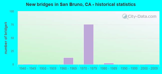
- New bridges - historical statistics
- 11940-1949
- 131960-1969
- 761970-1979
- 31980-1989
- 12000-2009
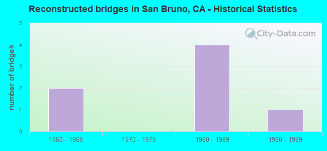
- Reconstructed bridges - Historical Statistics
- 21960-1969
- 01970-1979
- 41980-1989
- 11990-1999
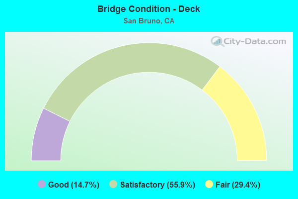
- Bridge Condition - Deck
- 14.7%Good
- 55.9%Satisfactory
- 29.4%Fair
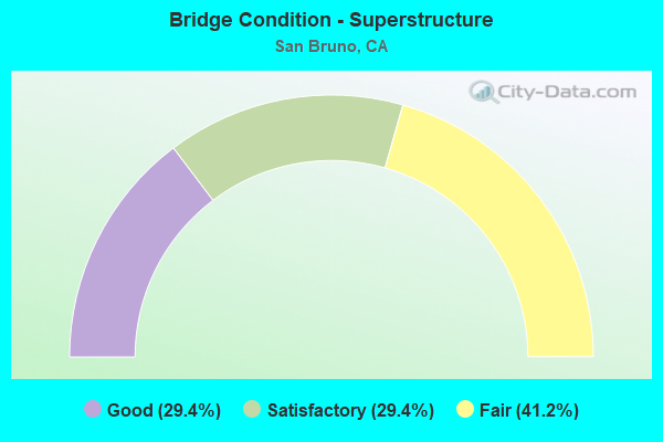
- Bridge Condition - Superstructure
- 29.4%Good
- 29.4%Satisfactory
- 41.2%Fair
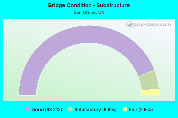
- Bridge Condition - Substructure
- 88.2%Good
- 8.8%Satisfactory
- 2.9%Fair
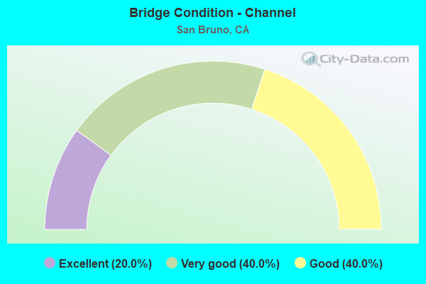
- Bridge Condition - Channel
- 20.0%Excellent
- 40.0%Very good
- 40.0%Good
Find on map >> Show street view
Structure Number: 35 0063F, Location: 04-SM-380-T4.71 (Lat: 37.629256, Lng: -122.432411), Route carried "on" structure: Ramp Interstate 380, Year Built: 1971, Year Reconstructed: 1996, Status: Open, Structure Length: 3.38m (11.09ft), Average Daily Traffic: 47,500 (year 2005), Truck Traffic: 5%, Average Future Daily Traffic: 55,617 (year 2042), Design Load: HS 20+Mod, Features Intersected: N280 ON-RAMP COLLECTOR
Minimum Vertical Clearance: 30+ m (98+ ft), Kilometerpoint: 4.710, Lanes on structure: 3, Lanes under structure: 2, Base Highway Network: Yes, Owner: State Highway Agency, Approaching Roadway Width: 15.9m (52.2ft), Skew: 9 degrees, Material/Design: Prestressed concrete, Design/Construction: Box Beam or Girders - Multiple, Number Of Spans In Main Unit: 1, Length of Maximum Span: 33.1m (108.6ft), Curb-To-Curb Width: 15.5m (50.9ft), Out-to-Out Width: 16.7m (54.8ft)
Condition: Deck: Satisfactory, Superstructure: Fair, Substructure: Good, Operating Rating: 78.7 metric tons, Method Used To Determine Operating Rating: Load Factor (LF), Inventory Rating: 32.4 metric tons, Method Used To Determine Inventory Rating: Load Factor (LF), Structural Evaluation: Somewhat better than minimum adequacy, Deck Geometry: Superior to present desirable criteria, Underclear: Somewhat better than minimum adequacy, Approach Roadway Alignment: Equal to present minimum criteria, Designated Inspection Frequency: Every 24 months, Inspection Date: Febuary 2022, Deck Structure Type: Concrete Cast-file-Place
Find on map >> Show street view
Structure Number: 35 0128Y, Location: 04-SM-101-R20.39 (Lat: 37.630819, Lng: -122.405244), Route carried "on" structure: US 101, Year Built: 1947, Status: Open, Structure Length: 1.04m (3.41ft), Average Daily Traffic: 10,100 (year 2000), Truck Traffic: 3%, Average Future Daily Traffic: 16,033 (year 2038), Features Intersected: SAN BRUNO CANAL, Facility Carried by Structure: SAN BRUNO AVENUE
Minimum Vertical Clearance: 30+ m (98+ ft), Kilometerpoint: 20.390, Lanes on structure: 2, Base Highway Network: Yes (Inventory Route: 1, Subroute: 1), Owner: State Highway Agency, Approaching Roadway Width: 20.1m (65.9ft), Skew: 20 degrees, Material/Design: Concrete continuous, Design/Construction: Culvert, Number Of Spans In Main Unit: 3, Length of Maximum Span: 3.0m (9.8ft)
Condition: Channel: Good, Culverts: Satisfactory, Operating Rating: 54.1 metric tons, Method Used To Determine Operating Rating: Field evaluation and documented engineering judgment, Inventory Rating: 32.4 metric tons, Method Used To Determine Inventory Rating: Field evaluation and documented engineering judgment, Structural Evaluation: Equal to present minimum criteria, Waterway Adequacy: Equal to present desirable criteria, Approach Roadway Alignment: Equal to present desirable criteria, Designated Inspection Frequency: Every 48 months, Inspection Date: April 2021
Find on map >> Show street view
Structure Number: 35 0196L, Location: 04-SM-280-R20.04-SBR (Lat: 37.614844, Lng: -122.424436), Route carried "on" structure: Interstate 280, Year Built: 1967, Status: Open, Structure Length: 8.85m (29.04ft), Average Daily Traffic: 49,500 (year 2009), Average Future Daily Traffic: 66,974 (year 2038), Design Load: HS 20+Mod, Features Intersected: CRYSTAL SPRINGS OFF-RAMP
Minimum Vertical Clearance: 30+ m (98+ ft), Kilometerpoint: 20.040, Lanes on structure: 4, Lanes under structure: 2, Base Highway Network: Yes (Inventory Route: 2, Subroute: 1), Owner: State Highway Agency, Approaching Roadway Width: 20.1m (65.9ft), Skew: 6 degrees, Material/Design: Concrete continuous, Design/Construction: Box Beam or Girders - Multiple, Number Of Spans In Main Unit: 3, Length of Maximum Span: 35.5m (116.5ft), Curb-To-Curb Width: 20.1m (65.9ft), Out-to-Out Width: 21.2m (69.6ft)
Condition: Deck: Satisfactory, Superstructure: Satisfactory, Substructure: Good, Operating Rating: 74.5 metric tons, Method Used To Determine Operating Rating: Load Factor (LF), Inventory Rating: 44.7 metric tons, Method Used To Determine Inventory Rating: Load Factor (LF), Structural Evaluation: Equal to present minimum criteria, Deck Geometry: Equal to present minimum criteria, Underclear: Meets minimum limits, Approach Roadway Alignment: Equal to present desirable criteria, Length Of Structure Improvement: 8.84m (29.00ft), Designated Inspection Frequency: Every 24 months, Inspection Date: July 2021, Deck Structure Type: Concrete Cast-file-Place
Find on map >> Show street view
Structure Number: 35 0196R, Location: 04-SM-280-R20.04-SBR (Lat: 37.614483, Lng: -122.424197), Route carried "on" structure: Interstate 280, Year Built: 1967, Status: Open, Structure Length: 7.63m (25.03ft), Average Daily Traffic: 49,500 (year 2009), Average Future Daily Traffic: 66,974 (year 2038), Design Load: HS 20+Mod, Features Intersected: CRYSTAL SPRINGS OFF-RAMP
Minimum Vertical Clearance: 30+ m (98+ ft), Kilometerpoint: 20.040, Lanes on structure: 4, Lanes under structure: 2, Base Highway Network: Yes (Inventory Route: 2, Subroute: 1), Owner: State Highway Agency, Approaching Roadway Width: 21.0m (68.9ft), Skew: 5 degrees, Material/Design: Concrete continuous, Design/Construction: Box Beam or Girders - Multiple, Number Of Spans In Main Unit: 3, Length of Maximum Span: 34.8m (114.2ft), Curb-To-Curb Width: 20.1m (65.9ft), Out-to-Out Width: 21.2m (69.6ft)
Condition: Deck: Satisfactory, Superstructure: Satisfactory, Substructure: Good, Operating Rating: 87.5 metric tons, Method Used To Determine Operating Rating: Load Factor (LF), Inventory Rating: 52.5 metric tons, Method Used To Determine Inventory Rating: Load Factor (LF), Structural Evaluation: Equal to present minimum criteria, Deck Geometry: Equal to present minimum criteria, Underclear: Meets minimum limits, Approach Roadway Alignment: Equal to present desirable criteria, Designated Inspection Frequency: Every 24 months, Inspection Date: July 2021, Deck Structure Type: Concrete Cast-file-Place
Find on map >> Show street view
Structure Number: 35 0197K, Location: 04-SM-280-R20.22-SBR (Lat: 37.617408, Lng: -122.424722), Route carried "on" structure: Bypass Interstate 280, Year Built: 1967, Status: Open, Structure Length: 4.76m (15.62ft), Average Daily Traffic: 5,600 (year 1998), Truck Traffic: 2%, Average Future Daily Traffic: 7,408 (year 2038), Design Load: HS 20+Mod, Features Intersected: WHITMAN WAY
Minimum Vertical Clearance: 30+ m (98+ ft), Kilometerpoint: 20.220, Lanes on structure: 2, Lanes under structure: 2, Base Highway Network: Yes (Inventory Route: 2, Subroute: 1), Owner: State Highway Agency, Approaching Roadway Width: 11.3m (37.1ft), Skew: 1 degrees, Material/Design: Concrete continuous, Design/Construction: Box Beam or Girders - Multiple, Number Of Spans In Main Unit: 3, Length of Maximum Span: 16.6m (54.5ft), Curb-To-Curb Width: 11.3m (37.1ft), Out-to-Out Width: 12.4m (40.7ft)
Condition: Deck: Satisfactory, Superstructure: Satisfactory, Substructure: Good, Operating Rating: 58.3 metric tons, Method Used To Determine Operating Rating: Load Factor (LF), Inventory Rating: 35.0 metric tons, Method Used To Determine Inventory Rating: Load Factor (LF), Structural Evaluation: Equal to present minimum criteria, Deck Geometry: Somewhat better than minimum adequacy, Underclear: Meets minimum limits, Approach Roadway Alignment: Equal to present desirable criteria, Designated Inspection Frequency: Every 48 months, Inspection Date: July 2021, Deck Structure Type: Concrete Cast-file-Place
Find on map >> Show street view
Structure Number: 35 0197L, Location: 04-SM-280-R20.22-SBR (Lat: 37.617428, Lng: -122.424408), Route carried "on" structure: Interstate 280, Year Built: 1967, Status: Open, Structure Length: 5.85m (19.19ft), Average Daily Traffic: 55,500 (year 2009), Average Future Daily Traffic: 73,962 (year 2036), Design Load: HS 20+Mod, Features Intersected: WHITMAN WAY
Minimum Vertical Clearance: 30+ m (98+ ft), Kilometerpoint: 20.220, Lanes on structure: 4, Lanes under structure: 2, Base Highway Network: Yes (Inventory Route: 2, Subroute: 1), Owner: State Highway Agency, Approaching Roadway Width: 20.1m (65.9ft), Skew: 1 degrees, Material/Design: Concrete continuous, Design/Construction: Box Beam or Girders - Multiple, Number Of Spans In Main Unit: 3, Length of Maximum Span: 19.9m (65.3ft), Curb-To-Curb Width: 20.1m (65.9ft), Out-to-Out Width: 21.2m (69.6ft)
Condition: Deck: Satisfactory, Superstructure: Good, Substructure: Good, Operating Rating: 84.2 metric tons, Method Used To Determine Operating Rating: Load Factor (LF), Inventory Rating: 50.5 metric tons, Method Used To Determine Inventory Rating: Load Factor (LF), Structural Evaluation: Better than present minimum criteria, Deck Geometry: Equal to present minimum criteria, Underclear: Meets minimum limits, Approach Roadway Alignment: Equal to present desirable criteria, Designated Inspection Frequency: Every 48 months, Inspection Date: July 2019, Deck Structure Type: Concrete Cast-file-Place
Find on map >> Show street view
Structure Number: 35 0197R, Location: 04-SM-280-R20.22-SBR (Lat: 37.617514, Lng: -122.424125), Route carried "on" structure: Interstate 280, Year Built: 1967, Status: Open, Structure Length: 5.89m (19.32ft), Average Daily Traffic: 55,500 (year 2009), Average Future Daily Traffic: 73,962 (year 2038), Design Load: HS 20+Mod, Features Intersected: WHITMAN WAY
Minimum Vertical Clearance: 30+ m (98+ ft), Kilometerpoint: 20.220, Lanes on structure: 5, Lanes under structure: 2, Base Highway Network: Yes (Inventory Route: 2, Subroute: 1), Owner: State Highway Agency, Approaching Roadway Width: 29.3m (96.1ft), Skew: 22 degrees, Material/Design: Concrete continuous, Design/Construction: Box Beam or Girders - Multiple, Number Of Spans In Main Unit: 3, Length of Maximum Span: 23.7m (77.8ft), Curb-To-Curb Width: 27.7m (90.9ft), Out-to-Out Width: 33.2m (108.9ft)
Condition: Deck: Satisfactory, Superstructure: Satisfactory, Substructure: Good, Operating Rating: 58.6 metric tons, Method Used To Determine Operating Rating: Load Factor (LF), Inventory Rating: 35.3 metric tons, Method Used To Determine Inventory Rating: Load Factor (LF), Structural Evaluation: Equal to present minimum criteria, Deck Geometry: Superior to present desirable criteria, Underclear: Meets minimum limits, Approach Roadway Alignment: Equal to present desirable criteria, Designated Inspection Frequency: Every 48 months, Inspection Date: July 2021, Deck Structure Type: Concrete Cast-file-Place
Find on map >> Show street view
Structure Number: 35 0201, Location: 04-SM-280-R19.36-SBR (Lat: 37.605803, Lng: -122.428483), Route carried "on" structure: City street D519, Year Built: 1967, Status: Open, Structure Length: 10.37m (34.02ft), Average Daily Traffic: 10,000 (year 2005), Truck Traffic: 3%, Average Future Daily Traffic: 12,614 (year 2038), Design Load: HS 20+Mod, Features Intersected: INTERSTATE 280, Facility Carried by Structure: CRYSTAL SPRINGS RD
Minimum Vertical Clearance: 30+ m (98+ ft), Kilometerpoint: 0.000, Lanes on structure: 2, Lanes under structure: 8, Base Highway Network: Yes, Owner: State Highway Agency, Approaching Roadway Width: 12.2m (40.0ft), Skew: 4 degrees, Material/Design: Prestressed concrete continuous, Design/Construction: Box Beam or Girders - Multiple, Number Of Spans In Main Unit: 2, Length of Maximum Span: 51.8m (169.9ft), Curb or Sidewalk Widths: Left: 1.5m (4.9ft), Right: 1.5m (4.9ft), Curb-To-Curb Width: 12.2m (40.0ft), Out-to-Out Width: 16.3m (53.5ft)
Condition: Deck: Fair, Superstructure: Good, Substructure: Fair, Operating Rating: 99.8 metric tons, Method Used To Determine Operating Rating: Load Factor (LF), Inventory Rating: 32.4 metric tons, Method Used To Determine Inventory Rating: Load Factor (LF), Structural Evaluation: Somewhat better than minimum adequacy, Deck Geometry: Somewhat better than minimum adequacy, Underclear: Equal to present minimum criteria, Approach Roadway Alignment: Equal to present desirable criteria, Designated Inspection Frequency: Every 24 months, Inspection Date: July 2021, Deck Structure Type: Concrete Cast-file-Place
Find on map >> Show street view
Structure Number: 35 0210L, Location: 04-SM-280-R14.22-HIL (Lat: 37.547175, Lng: -122.372475), Route carried "on" structure: Interstate 280, Year Built: 1969, Status: Open, Structure Length: 3.29m (10.79ft), Average Daily Traffic: 53,500 (year 1998), Truck Traffic: 3%, Average Future Daily Traffic: 80,137 (year 2038), Design Load: HS 20+Mod, Features Intersected: HAYNE ROAD
Minimum Vertical Clearance: 30+ m (98+ ft), Kilometerpoint: 14.220, Lanes on structure: 4, Lanes under structure: 4, Base Highway Network: Yes (Inventory Route: 2, Subroute: 1), Owner: State Highway Agency, Approaching Roadway Width: 20.1m (65.9ft), Material/Design: Prestressed concrete, Design/Construction: Box Beam or Girders - Multiple, Number Of Spans In Main Unit: 1, Length of Maximum Span: 32.2m (105.6ft), Curb-To-Curb Width: 20.1m (65.9ft), Out-to-Out Width: 21.2m (69.6ft)
Condition: Deck: Good, Superstructure: Fair, Substructure: Good, Operating Rating: 99.8 metric tons, Method Used To Determine Operating Rating: Load Factor (LF), Inventory Rating: 32.4 metric tons, Method Used To Determine Inventory Rating: Load Factor (LF), Structural Evaluation: Somewhat better than minimum adequacy, Deck Geometry: Equal to present minimum criteria, Underclear: Meets minimum limits, Approach Roadway Alignment: Equal to present desirable criteria, Designated Inspection Frequency: Every 24 months, Inspection Date: July 2021, Deck Structure Type: Concrete Cast-file-Place
Find on map >> Show street view
Structure Number: 35 0217, Location: 04-SM-280-R20.97-SBR (Lat: 37.627014, Lng: -122.430272), Route carried "on" structure: Interstate 280, Year Built: 1971, Status: Open, Structure Length: 10.56m (34.65ft), Average Daily Traffic: 101,000 (year 2009), Truck Traffic: 2%, Average Future Daily Traffic: 135,172 (year 2038), Design Load: HS 20+Mod, Features Intersected: I 380 & S280-E380 CNNCTR
Minimum Vertical Clearance: 30+ m (98+ ft), Kilometerpoint: 20.970, Lanes on structure: 8, Lanes under structure: 4, Base Highway Network: Yes (Inventory Route: 2, Subroute: 1), Owner: State Highway Agency, Approaching Roadway Width: 38.9m (127.6ft), Skew: 39 degrees, Material/Design: Prestressed concrete continuous, Design/Construction: Box Beam or Girders - Multiple, Number Of Spans In Main Unit: 3, Number Of Approach Spans: 4, Length of Maximum Span: 46.0m (150.9ft), Curb-To-Curb Width: 38.9m (127.6ft), Out-to-Out Width: 40.6m (133.2ft)
Condition: Deck: Fair, Superstructure: Fair, Substructure: Good, Operating Rating: 77.4 metric tons, Method Used To Determine Operating Rating: Load Factor (LF), Inventory Rating: 32.4 metric tons, Method Used To Determine Inventory Rating: Load Factor (LF), Structural Evaluation: Somewhat better than minimum adequacy, Deck Geometry: Superior to present desirable criteria, Underclear: High priority of corrective action, Approach Roadway Alignment: Equal to present desirable criteria, Designated Inspection Frequency: Every 24 months, Inspection Date: July 2021, Deck Structure Type: Concrete Cast-file-Place
Find on map >> Show street view
Structure Number: 35 0218S, Location: 04-SM-280-R20.96-SBR (Lat: 37.627136, Lng: -122.430031), Route carried "on" structure: Bypass Interstate 280, Year Built: 1971, Status: Open, Structure Length: 11.52m (37.80ft), Average Daily Traffic: 7,400 (year 1998), Truck Traffic: 2%, Average Future Daily Traffic: 9,299 (year 2038), Design Load: HS 20+Mod, Features Intersected: S280-E380 CONNECTOR RAMP
Minimum Vertical Clearance: 30+ m (98+ ft), Kilometerpoint: 20.960, Lanes on structure: 1, Lanes under structure: 2, Base Highway Network: Yes (Inventory Route: 2, Subroute: 1), Owner: State Highway Agency, Approaching Roadway Width: 7.9m (25.9ft), Skew: 9 degrees, Material/Design: Concrete continuous, Design/Construction: Box Beam or Girders - Multiple, Number Of Spans In Main Unit: 4, Length of Maximum Span: 35.1m (115.2ft), Curb-To-Curb Width: 11.0m (36.1ft), Out-to-Out Width: 12.1m (39.7ft)
Condition: Deck: Satisfactory, Superstructure: Fair, Substructure: Good, Operating Rating: 83.9 metric tons, Method Used To Determine Operating Rating: Load Factor (LF), Inventory Rating: 50.5 metric tons, Method Used To Determine Inventory Rating: Load Factor (LF), Structural Evaluation: Somewhat better than minimum adequacy, Deck Geometry: Meets minimum limits, Underclear: Meets minimum limits, Approach Roadway Alignment: Equal to present desirable criteria, Designated Inspection Frequency: Every 24 months, Inspection Date: July 2021, Deck Structure Type: Concrete Cast-file-Place
Find on map >> Show street view
Structure Number: 35 0219F, Location: 04-SM-380-4.65-SBR (Lat: 37.626886, Lng: -122.431625), Route carried "on" structure: Ramp Interstate 380, Year Built: 1971, Status: Open, Structure Length: 22.99m (75.43ft), Average Daily Traffic: 10,600 (year 1998), Truck Traffic: 5%, Average Future Daily Traffic: 33,371 (year 2042), Design Load: HS 20+Mod, Features Intersected: I 280, CONN, FRNTGE RD
Minimum Vertical Clearance: 30+ m (98+ ft), Kilometerpoint: 4.650, Lanes on structure: 2, Lanes under structure: 11, Base Highway Network: Yes, Owner: State Highway Agency, Approaching Roadway Width: 11.9m (39.0ft), Material/Design: Concrete continuous, Design/Construction: Box Beam or Girders - Multiple, Number Of Spans In Main Unit: 9, Length of Maximum Span: 31.6m (103.7ft), Curb-To-Curb Width: 11.9m (39.0ft), Out-to-Out Width: 13.0m (42.7ft)
Condition: Deck: Satisfactory, Superstructure: Good, Substructure: Good, Operating Rating: 99.8 metric tons, Method Used To Determine Operating Rating: Load Factor (LF), Inventory Rating: 64.5 metric tons, Method Used To Determine Inventory Rating: Load Factor (LF), Structural Evaluation: Better than present minimum criteria, Deck Geometry: Superior to present desirable criteria, Underclear: Somewhat better than minimum adequacy, Approach Roadway Alignment: Equal to present minimum criteria, Designated Inspection Frequency: Every 24 months, Inspection Date: Febuary 2022, Deck Structure Type: Concrete Cast-file-Place
Find on map >> Show street view
Structure Number: 35 0221L, Location: 04-SM-380-4.67-SBR (Lat: 37.627233, Lng: -122.431717), Route carried "on" structure: Interstate 380, Year Built: 1973, Status: Open, Structure Length: 4.35m (14.27ft), Average Daily Traffic: 10 (year 2008), Truck Traffic: 2%, Average Future Daily Traffic: 10 (year 2042), Design Load: HS 20+Mod, Features Intersected: S280-E380 CONNECTOR RAMP
Minimum Vertical Clearance: 30+ m (98+ ft), Kilometerpoint: 4.670, Lanes on structure: 4, Lanes under structure: 2, Base Highway Network: Yes (Inventory Route: 3, Subroute: 1), Owner: State Highway Agency, Approaching Roadway Width: 20.0m (65.6ft), Skew: 9 degrees, Material/Design: Prestressed concrete, Design/Construction: Box Beam or Girders - Multiple, Number Of Spans In Main Unit: 1, Length of Maximum Span: 42.7m (140.1ft), Curb-To-Curb Width: 20.0m (65.6ft), Out-to-Out Width: 21.0m (68.9ft)
Condition: Deck: Good, Superstructure: Good, Substructure: Good, Operating Rating: 99.8 metric tons, Method Used To Determine Operating Rating: Load Factor (LF), Inventory Rating: 32.4 metric tons, Method Used To Determine Inventory Rating: Load Factor (LF), Structural Evaluation: Better than present minimum criteria, Deck Geometry: Equal to present minimum criteria, Underclear: Better than present minimum criteria, Approach Roadway Alignment: Equal to present desirable criteria, Designated Inspection Frequency: Every 24 months, Inspection Date: Febuary 2022, Deck Structure Type: Concrete Cast-file-Place
Find on map >> Show street view
Structure Number: 35 0221R, Location: 04-SM-380-4.67-SBR (Lat: 37.627125, Lng: -122.431325), Route carried "on" structure: Interstate 380, Year Built: 1973, Status: Open, Structure Length: 4.59m (15.06ft), Average Daily Traffic: 10 (year 2008), Truck Traffic: 2%, Average Future Daily Traffic: 10 (year 2042), Design Load: HS 20+Mod, Features Intersected: S280-E380 CONNECTOR RAMP
Minimum Vertical Clearance: 30+ m (98+ ft), Kilometerpoint: 4.670, Lanes on structure: 4, Lanes under structure: 2, Base Highway Network: Yes (Inventory Route: 3, Subroute: 1), Owner: State Highway Agency, Approaching Roadway Width: 20.0m (65.6ft), Skew: 9 degrees, Material/Design: Prestressed concrete, Design/Construction: Box Beam or Girders - Multiple, Number Of Spans In Main Unit: 1, Length of Maximum Span: 45.1m (148.0ft), Curb-To-Curb Width: 20.0m (65.6ft), Out-to-Out Width: 21.0m (68.9ft)
Condition: Deck: Good, Superstructure: Fair, Substructure: Good, Operating Rating: 99.8 metric tons, Method Used To Determine Operating Rating: Load Factor (LF), Inventory Rating: 32.4 metric tons, Method Used To Determine Inventory Rating: Load Factor (LF), Structural Evaluation: Somewhat better than minimum adequacy, Deck Geometry: Equal to present minimum criteria, Underclear: Superior to present desirable criteria, Approach Roadway Alignment: Equal to present desirable criteria, Designated Inspection Frequency: Every 24 months, Inspection Date: Febuary 2022, Deck Structure Type: Concrete Cast-file-Place
Find on map >> Show street view
Structure Number: 35 0223, Location: 04-SM-380-5.45-SBR (Lat: 37.632658, Lng: -122.419278), Route carried "on" structure: Interstate 380, Year Built: 1971, Status: Open, Structure Length: 5.49m (18.01ft), Average Daily Traffic: 115,000 (year 1998), Truck Traffic: 4%, Average Future Daily Traffic: 220,694 (year 2042), Design Load: HS 20+Mod, Features Intersected: SR 82 (EL CAMINO REAL)
Minimum Vertical Clearance: 30+ m (98+ ft), Kilometerpoint: 5.450, Lanes on structure: 10, Lanes under structure: 8, Base Highway Network: Yes (Inventory Route: 3, Subroute: 1), Owner: State Highway Agency, Approaching Roadway Width: 50.0m (164.0ft), Skew: 30 degrees, Material/Design: Concrete continuous, Design/Construction: Box Beam or Girders - Multiple, Number Of Spans In Main Unit: 2, Length of Maximum Span: 27.4m (89.9ft), Curb-To-Curb Width: 50.0m (164.0ft), Out-to-Out Width: 51.5m (169.0ft)
Condition: Deck: Fair, Superstructure: Fair, Substructure: Good, Operating Rating: 99.8 metric tons, Method Used To Determine Operating Rating: Load Factor (LF), Inventory Rating: 64.5 metric tons, Method Used To Determine Inventory Rating: Load Factor (LF), Structural Evaluation: Somewhat better than minimum adequacy, Deck Geometry: Superior to present desirable criteria, Underclear: Somewhat better than minimum adequacy, Approach Roadway Alignment: Equal to present desirable criteria, Designated Inspection Frequency: Every 24 months, Inspection Date: Febuary 2022, Deck Structure Type: Concrete Cast-file-Place
Find on map >> Show street view
Structure Number: 35 0225, Location: 04-SM-280-R21.30-SBR (Lat: 37.630100, Lng: -122.435439), Route carried "on" structure: City street D538, Year Built: 1971, Status: Open, Structure Length: 11.01m (36.12ft), Average Daily Traffic: 20,000 (year 1998), Truck Traffic: 3%, Average Future Daily Traffic: 25,010 (year 2038), Design Load: HS 20+Mod, Features Intersected: INTERSTATE 280, Facility Carried by Structure: SNEATH LANE
Minimum Vertical Clearance: 30+ m (98+ ft), Kilometerpoint: 0.000, Lanes on structure: 4, Lanes under structure: 12, Base Highway Network: Yes, Owner: State Highway Agency, Approaching Roadway Width: 15.9m (52.2ft), Skew: 2 degrees, Material/Design: Prestressed concrete continuous, Design/Construction: Box Beam or Girders - Multiple, Number Of Spans In Main Unit: 4, Length of Maximum Span: 32.0m (105.0ft), Curb or Sidewalk Widths: Left: 1.8m (5.9ft), Right: 1.8m (5.9ft), Curb-To-Curb Width: 15.9m (52.2ft), Out-to-Out Width: 20.5m (67.3ft)
Condition: Deck: Fair, Superstructure: Fair, Substructure: Good, Operating Rating: 99.8 metric tons, Method Used To Determine Operating Rating: Load Factor (LF), Inventory Rating: 32.4 metric tons, Method Used To Determine Inventory Rating: Load Factor (LF), Structural Evaluation: Somewhat better than minimum adequacy, Deck Geometry: Meets minimum limits, Underclear: High priority of corrective action, Approach Roadway Alignment: Equal to present desirable criteria, Designated Inspection Frequency: Every 24 months, Inspection Date: July 2021, Deck Structure Type: Concrete Cast-file-Place
Find on map >> Show street view
Structure Number: 35 0226, Location: 04-SM-380-T4.98-SBR (Lat: 37.629300, Lng: -122.426589), Route carried "on" structure: Interstate 380, Year Built: 1971, Year Reconstructed: 1973, Status: Open, Structure Length: 4.12m (13.52ft), Average Daily Traffic: 122,000 (year 2009), Truck Traffic: 3%, Average Future Daily Traffic: 159,044 (year 2042), Design Load: HS 20, Features Intersected: CHERRY AVENUE
Minimum Vertical Clearance: 30+ m (98+ ft), Kilometerpoint: 4.980, Lanes on structure: 7, Lanes under structure: 4, Base Highway Network: Yes (Inventory Route: 3, Subroute: 1), Owner: State Highway Agency, Approaching Roadway Width: 36.6m (120.1ft), Skew: 30 degrees, Material/Design: Concrete continuous, Design/Construction: Box Beam or Girders - Multiple, Number Of Spans In Main Unit: 2, Length of Maximum Span: 21.4m (70.2ft), Curb-To-Curb Width: 67.9m (222.8ft), Out-to-Out Width: 71.0m (232.9ft)
Condition: Deck: Fair, Superstructure: Satisfactory, Substructure: Good, Operating Rating: 99.1 metric tons, Method Used To Determine Operating Rating: Load Factor (LF), Inventory Rating: 59.6 metric tons, Method Used To Determine Inventory Rating: Load Factor (LF), Structural Evaluation: Equal to present minimum criteria, Deck Geometry: Superior to present desirable criteria, Underclear: Meets minimum limits, Approach Roadway Alignment: Equal to present desirable criteria, Designated Inspection Frequency: Every 24 months, Inspection Date: Febuary 2022, Deck Structure Type: Concrete Cast-file-Place
Find on map >> Show street view
Structure Number: 35 0227, Location: 04-SM-280-R20.75-SBR (Lat: 37.624475, Lng: -122.428131), Route carried "on" structure: Interstate 280, Year Built: 1971, Status: Open, Structure Length: 4.88m (16.01ft), Average Daily Traffic: 101,000 (year 2009), Truck Traffic: 2%, Average Future Daily Traffic: 136,075 (year 2038), Design Load: HS 20+Mod, Features Intersected: SAN BRUNO AVENUE
Minimum Vertical Clearance: 30+ m (98+ ft), Kilometerpoint: 20.750, Lanes on structure: 12, Lanes under structure: 8, Base Highway Network: Yes (Inventory Route: 2, Subroute: 1), Owner: State Highway Agency, Approaching Roadway Width: 56.1m (184.1ft), Skew: 32 degrees, Material/Design: Concrete continuous, Design/Construction: Box Beam or Girders - Multiple, Number Of Spans In Main Unit: 2, Length of Maximum Span: 24.7m (81.0ft), Curb-To-Curb Width: 56.1m (184.1ft), Out-to-Out Width: 57.8m (189.6ft)
Condition: Deck: Fair, Superstructure: Satisfactory, Substructure: Good, Operating Rating: 99.8 metric tons, Method Used To Determine Operating Rating: Load Factor (LF), Inventory Rating: 72.3 metric tons, Method Used To Determine Inventory Rating: Load Factor (LF), Structural Evaluation: Equal to present minimum criteria, Deck Geometry: Superior to present desirable criteria, Underclear: High priority of corrective action, Approach Roadway Alignment: Equal to present desirable criteria, Designated Inspection Frequency: Every 24 months, Inspection Date: July 2021, Deck Structure Type: Concrete Cast-file-Place
Find on map >> Show street view
Structure Number: 35 0250L, Location: 04-SM-280-6.65 (Lat: 37.468239, Lng: -122.292233), Route carried "on" structure: Interstate 280, Year Built: 1973, Status: Open, Structure Length: 6.07m (19.91ft), Average Daily Traffic: 50,000 (year 2009), Truck Traffic: 3%, Average Future Daily Traffic: 67,280 (year 2038), Design Load: HS 20, Features Intersected: EDGEWOOD ROAD
Minimum Vertical Clearance: 30+ m (98+ ft), Kilometerpoint: 6.650, Lanes on structure: 5, Lanes under structure: 4, Base Highway Network: Yes (Inventory Route: 2, Subroute: 1), Owner: State Highway Agency, Approaching Roadway Width: 25.9m (85.0ft), Skew: 2 degrees, Material/Design: Concrete continuous, Design/Construction: Box Beam or Girders - Multiple, Number Of Spans In Main Unit: 2, Length of Maximum Span: 30.4m (99.7ft), Curb-To-Curb Width: 25.9m (85.0ft), Out-to-Out Width: 27.0m (88.6ft)
Condition: Deck: Satisfactory, Superstructure: Fair, Substructure: Good, Operating Rating: 99.8 metric tons, Method Used To Determine Operating Rating: Load Factor (LF), Inventory Rating: 75.8 metric tons, Method Used To Determine Inventory Rating: Load Factor (LF), Structural Evaluation: Somewhat better than minimum adequacy, Deck Geometry: Superior to present desirable criteria, Underclear: Better than present minimum criteria, Approach Roadway Alignment: Equal to present desirable criteria, Designated Inspection Frequency: Every 24 months, Inspection Date: October 2021, Deck Structure Type: Concrete Cast-file-Place
Find on map >> Show street view
Structure Number: 35 0253, Location: 04-SM-380-5.73-SBR (Lat: 37.634058, Lng: -122.414508), Route carried "on" structure: Interstate 380, Year Built: 1971, Year Reconstructed: 1973, Status: Open, Structure Length: 31.43m (103.12ft), Average Daily Traffic: 150,000 (year 1998), Truck Traffic: 5%, Average Future Daily Traffic: 255,844 (year 2042), Design Load: HS 20, Features Intersected: CALTRAIN,UP RR,BART,ETC
Minimum Vertical Clearance: 30+ m (98+ ft), Kilometerpoint: 5.730, Lanes on structure: 10, Lanes under structure: 8, Base Highway Network: Yes (Inventory Route: 3, Subroute: 1), Owner: State Highway Agency, Approaching Roadway Width: 61.4m (201.4ft), Skew: 39 degrees, Material/Design: Prestressed concrete continuous, Design/Construction: Box Beam or Girders - Multiple, Number Of Spans In Main Unit: 12, Length of Maximum Span: 42.7m (140.1ft), Curb-To-Curb Width: 61.4m (201.4ft), Out-to-Out Width: 63.0m (206.7ft)
Condition: Deck: Fair, Superstructure: Good, Substructure: Good, Operating Rating: 74.2 metric tons, Method Used To Determine Operating Rating: Load Factor (LF), Inventory Rating: 32.4 metric tons, Method Used To Determine Inventory Rating: Load Factor (LF), Structural Evaluation: Better than present minimum criteria, Deck Geometry: Superior to present desirable criteria, Underclear: Better than present minimum criteria, Approach Roadway Alignment: Equal to present desirable criteria, Designated Inspection Frequency: Every 24 months, Inspection Date: Febuary 2022, Deck Structure Type: Concrete Cast-file-Place
Find on map >> Show street view
Structure Number: 35 0254G, Location: 04-SM-380-6.37-SBR (Lat: 37.634128, Lng: -122.406206), Route carried "on" structure: Ramp Interstate 380, Year Built: 1976, Status: Open, Structure Length: 50.30m (165.03ft), Average Daily Traffic: 19,500 (year 2005), Truck Traffic: 6%, Average Future Daily Traffic: 28,922 (year 2042), Design Load: HS 20, Features Intersected: I 380,US 101, RAMPS, 7TH
Minimum Vertical Clearance: 30+ m (98+ ft), Kilometerpoint: 6.370, Lanes on structure: 2, Lanes under structure: 6, Base Highway Network: Yes, Owner: State Highway Agency, Approaching Roadway Width: 11.9m (39.0ft), Skew: 9 degrees, Material/Design: Prestressed concrete continuous, Design/Construction: Box Beam or Girders - Multiple, Number Of Spans In Main Unit: 5, Number Of Approach Spans: 7, Length of Maximum Span: 57.9m (190.0ft), Curb-To-Curb Width: 12.2m (40.0ft), Out-to-Out Width: 13.1m (43.0ft)
Condition: Deck: Satisfactory, Superstructure: Fair, Substructure: Good, Operating Rating: 54.1 metric tons, Method Used To Determine Operating Rating: Field evaluation and documented engineering judgment, Inventory Rating: 32.4 metric tons, Method Used To Determine Inventory Rating: Field evaluation and documented engineering judgment, Structural Evaluation: Somewhat better than minimum adequacy, Deck Geometry: Superior to present desirable criteria, Underclear: High priority of corrective action, Approach Roadway Alignment: Equal to present minimum criteria, Designated Inspection Frequency: Every 24 months, Inspection Date: Febuary 2022, Deck Structure Type: Concrete Cast-file-Place
Find on map >> Show street view
Structure Number: 35 0255L, Location: 04-SM-380-6.33-SBR (Lat: 37.635683, Lng: -122.404353), Route carried "on" structure: Interstate 380, Year Built: 1976, Year Reconstructed: 1987, Status: Open, Structure Length: 61.51m (201.80ft), Average Daily Traffic: 75,000 (year 1998), Truck Traffic: 5%, Average Future Daily Traffic: 127,922 (year 2042), Design Load: HS 20, Features Intersected: US 101, RAMPS, CITY ST
Minimum Vertical Clearance: 5.23m (17.16ft), Kilometerpoint: 6.330, Lanes on structure: 4, Lanes under structure: 11, Base Highway Network: Yes (Inventory Route: 3, Subroute: 1), Owner: State Highway Agency, Approaching Roadway Width: 11.9m (39.0ft), Skew: 9 degrees, Material/Design: Prestressed concrete continuous, Design/Construction: Box Beam or Girders - Multiple, Number Of Spans In Main Unit: 6, Number Of Approach Spans: 14, Length of Maximum Span: 43.0m (141.1ft), Curb-To-Curb Width: 12.6m (41.3ft), Out-to-Out Width: 13.6m (44.6ft)
Condition: Deck: Satisfactory, Superstructure: Fair, Substructure: Good, Operating Rating: 54.1 metric tons, Method Used To Determine Operating Rating: Field evaluation and documented engineering judgment, Inventory Rating: 32.4 metric tons, Method Used To Determine Inventory Rating: Field evaluation and documented engineering judgment, Structural Evaluation: Somewhat better than minimum adequacy, Deck Geometry: High priority of replacement, Underclear: Somewhat better than minimum adequacy, Approach Roadway Alignment: Equal to present minimum criteria, Designated Inspection Frequency: Every 24 months, Inspection Date: Febuary 2022, Deck Structure Type: Concrete Cast-file-Place
Find on map >> Show street view
Structure Number: 35 0255R, Location: 04-SM-380-6.32-SBR (Lat: 37.635242, Lng: -122.404386), Route carried "on" structure: Interstate 380, Year Built: 1976, Year Reconstructed: 1987, Status: Open, Structure Length: 67.85m (222.60ft), Average Daily Traffic: 75,000 (year 1998), Truck Traffic: 5%, Average Future Daily Traffic: 127,922 (year 2042), Design Load: HS 20, Features Intersected: US 101, RAMPS, CITY ST
Minimum Vertical Clearance: 5.36m (17.59ft), Kilometerpoint: 6.320, Lanes on structure: 2, Lanes under structure: 12, Base Highway Network: Yes (Inventory Route: 3, Subroute: 1), Owner: State Highway Agency, Approaching Roadway Width: 11.9m (39.0ft), Skew: 9 degrees, Material/Design: Prestressed concrete continuous, Design/Construction: Box Beam or Girders - Multiple, Number Of Spans In Main Unit: 2, Number Of Approach Spans: 17, Length of Maximum Span: 43.3m (142.1ft), Curb-To-Curb Width: 12.2m (40.0ft), Out-to-Out Width: 13.2m (43.3ft)
Condition: Deck: Satisfactory, Superstructure: Fair, Substructure: Good, Operating Rating: 54.1 metric tons, Method Used To Determine Operating Rating: Field evaluation and documented engineering judgment, Inventory Rating: 32.4 metric tons, Method Used To Determine Inventory Rating: Field evaluation and documented engineering judgment, Structural Evaluation: Somewhat better than minimum adequacy, Deck Geometry: Better than present minimum criteria, Underclear: Somewhat better than minimum adequacy, Approach Roadway Alignment: Equal to present minimum criteria, Designated Inspection Frequency: Every 24 months, Inspection Date: Febuary 2022, Deck Structure Type: Concrete Cast-file-Place
Find on map >> Show street view
Structure Number: 35 0256F, Location: 04-SM-101-R20.65-SBR (Lat: 37.634778, Lng: -122.406256), Route carried "on" structure: Ramp US 101, Year Built: 1976, Status: Open, Structure Length: 4.83m (15.85ft), Average Daily Traffic: 17,000 (year 1998), Truck Traffic: 6%, Average Future Daily Traffic: 55,425 (year 2038), Features Intersected: 7TH AVENUE
Minimum Vertical Clearance: 30+ m (98+ ft), Kilometerpoint: 20.650, Lanes on structure: 2, Lanes under structure: 2, Base Highway Network: Yes (Inventory Route: 1, Subroute: 1), Owner: State Highway Agency, Approaching Roadway Width: 11.9m (39.0ft), Skew: 3 degrees, Material/Design: Concrete continuous, Design/Construction: Box Beam or Girders - Multiple, Number Of Spans In Main Unit: 2, Length of Maximum Span: 25.4m (83.3ft), Curb-To-Curb Width: 12.2m (40.0ft), Out-to-Out Width: 13.1m (43.0ft)
Condition: Deck: Fair, Superstructure: Good, Substructure: Good, Operating Rating: 54.1 metric tons, Method Used To Determine Operating Rating: Field evaluation and documented engineering judgment, Inventory Rating: 32.4 metric tons, Method Used To Determine Inventory Rating: Field evaluation and documented engineering judgment, Structural Evaluation: Better than present minimum criteria, Deck Geometry: Superior to present desirable criteria, Underclear: High priority of corrective action, Approach Roadway Alignment: Equal to present minimum criteria, Designated Inspection Frequency: Every 24 months, Inspection Date: April 2021, Deck Structure Type: Concrete Cast-file-Place
Find on map >> Show street view
Structure Number: 35 0261L, Location: 04-SM-380-6.20-SBR (Lat: 37.634586, Lng: -122.406214), Route carried "on" structure: Interstate 380, Year Built: 1976, Status: Open, Structure Length: 4.05m (13.29ft), Average Daily Traffic: 75,000 (year 1998), Truck Traffic: 5%, Average Future Daily Traffic: 127,922 (year 2042), Design Load: HS 20, Features Intersected: 7TH AVENUE
Minimum Vertical Clearance: 30+ m (98+ ft), Kilometerpoint: 6.200, Lanes on structure: 1, Lanes under structure: 2, Base Highway Network: Yes (Inventory Route: 3, Subroute: 1), Owner: State Highway Agency, Approaching Roadway Width: 12.2m (40.0ft), Skew: 2 degrees, Material/Design: Prestressed concrete, Design/Construction: Box Beam or Girders - Multiple, Number Of Spans In Main Unit: 1, Length of Maximum Span: 39.3m (128.9ft), Curb-To-Curb Width: 12.2m (40.0ft), Out-to-Out Width: 13.1m (43.0ft)
Condition: Deck: Good, Superstructure: Good, Substructure: Good, Operating Rating: 73.9 metric tons, Method Used To Determine Operating Rating: Load and Resistance Factor Rating (LRFR) rating reported by rating factor(RF) method using HL-93 loadings, Inventory Rating: 48.9 metric tons, Method Used To Determine Inventory Rating: Load and Resistance Factor Rating (LRFR) rating reported by rating factor(RF) method using HL-93 loadings, Structural Evaluation: Better than present minimum criteria, Deck Geometry: Somewhat better than minimum adequacy, Underclear: Meets minimum limits, Approach Roadway Alignment: Equal to present desirable criteria, Designated Inspection Frequency: Every 24 months, Inspection Date: Febuary 2022, Deck Structure Type: Concrete Cast-file-Place
Find on map >> Show street view
Structure Number: 35 0261R, Location: 04-SM-380-6.20-SBR (Lat: 37.634275, Lng: -122.406206), Route carried "on" structure: Interstate 380, Year Built: 1976, Status: Open, Structure Length: 4.39m (14.40ft), Average Daily Traffic: 75,000 (year 1998), Truck Traffic: 5%, Average Future Daily Traffic: 127,922 (year 2042), Design Load: HS 20, Features Intersected: 7TH AVENUE
Minimum Vertical Clearance: 30+ m (98+ ft), Kilometerpoint: 6.200, Lanes on structure: 2, Lanes under structure: 2, Base Highway Network: Yes (Inventory Route: 3, Subroute: 1), Owner: State Highway Agency, Approaching Roadway Width: 12.2m (40.0ft), Skew: 2 degrees, Material/Design: Prestressed concrete, Design/Construction: Box Beam or Girders - Multiple, Number Of Spans In Main Unit: 1, Length of Maximum Span: 42.7m (140.1ft), Curb-To-Curb Width: 12.2m (40.0ft), Out-to-Out Width: 13.1m (43.0ft)
Condition: Deck: Good, Superstructure: Good, Substructure: Good, Operating Rating: 79.7 metric tons, Method Used To Determine Operating Rating: Load and Resistance Factor Rating (LRFR) rating reported by rating factor(RF) method using HL-93 loadings, Inventory Rating: 51.5 metric tons, Method Used To Determine Inventory Rating: Load and Resistance Factor Rating (LRFR) rating reported by rating factor(RF) method using HL-93 loadings, Structural Evaluation: Better than present minimum criteria, Deck Geometry: Better than present minimum criteria, Underclear: Meets minimum limits, Approach Roadway Alignment: Equal to present desirable criteria, Designated Inspection Frequency: Every 24 months, Inspection Date: Febuary 2022, Deck Structure Type: Concrete Cast-file-Place
Find on map >> Show street view
Structure Number: 35 0262G, Location: 04-SM-101-R20.52 (Lat: 37.632028, Lng: -122.402303), Route carried "on" structure: Ramp US 101, Year Built: 1976, Status: Open, Structure Length: 71.28m (233.86ft), Average Daily Traffic: 43,500 (year 1998), Truck Traffic: 4%, Average Future Daily Traffic: 28,256 (year 2038), Design Load: HS 20+Mod, Features Intersected: I 380, US 101, 7TH, CONN
Minimum Vertical Clearance: 30+ m (98+ ft), Kilometerpoint: 20.520, Lanes on structure: 2, Lanes under structure: 26, Base Highway Network: Yes (Inventory Route: 1, Subroute: 1), Owner: State Highway Agency, Approaching Roadway Width: 11.9m (39.0ft), Skew: 1 degrees, Material/Design: Prestressed concrete continuous, Design/Construction: Box Beam or Girders - Multiple, Number Of Spans In Main Unit: 4, Number Of Approach Spans: 15, Length of Maximum Span: 57.3m (188.0ft), Curb-To-Curb Width: 12.2m (40.0ft), Out-to-Out Width: 13.1m (43.0ft)
Condition: Deck: Fair, Superstructure: Fair, Substructure: Good, Channel: Excellent, Operating Rating: 54.1 metric tons, Method Used To Determine Operating Rating: Field evaluation and documented engineering judgment, Inventory Rating: 32.4 metric tons, Method Used To Determine Inventory Rating: Field evaluation and documented engineering judgment, Structural Evaluation: Somewhat better than minimum adequacy, Deck Geometry: Superior to present desirable criteria, Underclear: High priority of corrective action, Waterway Adequacy: Superior to present desirable criteria, Approach Roadway Alignment: Equal to present minimum criteria, Designated Inspection Frequency: Every 24 months, Inspection Date: April 2021, Deck Structure Type: Concrete Cast-file-Place
Find on map >> Show street view
Structure Number: 35 0263G, Location: 04-SM-380-6.19-SBR (Lat: 37.633794, Lng: -122.406167), Route carried "on" structure: Ramp Interstate 380, Year Built: 1976, Status: Open, Structure Length: 41.74m (136.94ft), Average Daily Traffic: 42,000 (year 2005), Truck Traffic: 6%, Average Future Daily Traffic: 104,562 (year 2042), Design Load: HS 20, Features Intersected: S101-SAN BRUNO AV,7TH AV
Minimum Vertical Clearance: 30+ m (98+ ft), Kilometerpoint: 6.190, Lanes on structure: 2, Lanes under structure: 5, Base Highway Network: Yes, Owner: State Highway Agency, Approaching Roadway Width: 11.9m (39.0ft), Material/Design: Prestressed concrete continuous, Design/Construction: Box Beam or Girders - Multiple, Number Of Spans In Main Unit: 6, Number Of Approach Spans: 6, Length of Maximum Span: 45.6m (149.6ft), Curb-To-Curb Width: 12.2m (40.0ft), Out-to-Out Width: 13.1m (43.0ft)
Condition: Deck: Fair, Superstructure: Good, Substructure: Good, Channel: Very good, Operating Rating: 58.3 metric tons, Method Used To Determine Operating Rating: Load and Resistance Factor Rating (LRFR) rating reported by rating factor(RF) method using HL-93 loadings, Inventory Rating: 37.6 metric tons, Method Used To Determine Inventory Rating: Load and Resistance Factor Rating (LRFR) rating reported by rating factor(RF) method using HL-93 loadings, Structural Evaluation: Better than present minimum criteria, Deck Geometry: Superior to present desirable criteria, Underclear: Meets minimum limits, Waterway Adequacy: Equal to present desirable criteria, Approach Roadway Alignment: Equal to present minimum criteria, Designated Inspection Frequency: Every 24 months, Inspection Date: Febuary 2022, Deck Structure Type: Concrete Cast-file-Place
Find on map >> Show street view
Structure Number: 35 0264, Location: 04-SM-101-R20.39-SBR (Lat: 37.630908, Lng: -122.403672), Route carried "on" structure: City street D509, Year Built: 1976, Status: Open, Structure Length: 16.76m (54.99ft), Average Daily Traffic: 30,659 (year 2002), Truck Traffic: 5%, Average Future Daily Traffic: 37,632 (year 2038), Design Load: HS 20, Features Intersected: U.S. HIGHWAY 101, Facility Carried by Structure: SAN BRUNO AVENUE
Minimum Vertical Clearance: 30+ m (98+ ft), Kilometerpoint: 0.000, Lanes on structure: 5, Lanes under structure: 16, Base Highway Network: Yes, Owner: State Highway Agency, Approaching Roadway Width: 24.4m (80.1ft), Skew: 21 degrees, Material/Design: Concrete continuous, Design/Construction: Box Beam or Girders - Multiple, Number Of Spans In Main Unit: 4, Number Of Approach Spans: 2, Length of Maximum Span: 38.6m (126.6ft), Curb or Sidewalk Widths: Left: 1.5m (4.9ft), Right: 1.5m (4.9ft), Curb-To-Curb Width: 23.2m (76.1ft), Out-to-Out Width: 28.6m (93.8ft)
Condition: Deck: Satisfactory, Superstructure: Good, Substructure: Good, Operating Rating: 82.6 metric tons, Method Used To Determine Operating Rating: Load Factor (LF), Inventory Rating: 32.4 metric tons, Method Used To Determine Inventory Rating: Load Factor (LF), Structural Evaluation: Better than present minimum criteria, Deck Geometry: Better than present minimum criteria, Underclear: High priority of corrective action, Approach Roadway Alignment: Equal to present desirable criteria, Designated Inspection Frequency: Every 24 months, Inspection Date: April 2021, Deck Structure Type: Concrete Cast-file-Place
Find on map >> Show street view
Structure Number: 35 0271F, Location: 04-SM-380-6.40-SBR (Lat: 37.633625, Lng: -122.403400), Route carried "on" structure: Ramp Interstate 380, Year Built: 1976, Year Reconstructed: 1987, Status: Open, Structure Length: 89.15m (292.49ft), Average Daily Traffic: 5,000 (year 2001), Truck Traffic: 6%, Average Future Daily Traffic: 8,342 (year 2042), Design Load: HS 20, Features Intersected: US 101,I 380,EB CON,RMPS
Minimum Vertical Clearance: 5.48m (17.98ft), Kilometerpoint: 6.400, Lanes on structure: 2, Lanes under structure: 15, Base Highway Network: Yes, Owner: State Highway Agency, Approaching Roadway Width: 6.7m (22.0ft), Material/Design: Prestressed concrete continuous, Design/Construction: Box Beam or Girders - Multiple, Number Of Spans In Main Unit: 20, Length of Maximum Span: 65.5m (214.9ft), Curb-To-Curb Width: 6.9m (22.6ft), Out-to-Out Width: 12.2m (40.0ft)
Condition: Deck: Satisfactory, Superstructure: Fair, Substructure: Good, Operating Rating: 54.1 metric tons, Method Used To Determine Operating Rating: Field evaluation and documented engineering judgment, Inventory Rating: 32.4 metric tons, Method Used To Determine Inventory Rating: Field evaluation and documented engineering judgment, Structural Evaluation: Somewhat better than minimum adequacy, Deck Geometry: High priority of replacement, Underclear: Meets minimum limits, Approach Roadway Alignment: Equal to present minimum criteria, Designated Inspection Frequency: Every 24 months, Inspection Date: Febuary 2022, Deck Structure Type: Concrete Cast-file-Place
Find on map >> Show street view
Structure Number: 35 0272H, Location: 04-SM-101-R20.69-SBR (Lat: 37.634578, Lng: -122.402808), Route carried "on" structure: Ramp US 101, Year Built: 1976, Year Reconstructed: 1987, Status: Open, Structure Length: 66.68m (218.77ft), Average Daily Traffic: 10,000 (year 1998), Truck Traffic: 2%, Average Future Daily Traffic: 16,459 (year 2038), Features Intersected: US 101, RMPS, NORTH CHNL
Minimum Vertical Clearance: 4.75m (15.58ft), Kilometerpoint: 20.690, Lanes on structure: 1, Lanes under structure: 17, Base Highway Network: Yes, Owner: State Highway Agency, Approaching Roadway Width: 8.1m (26.6ft), Skew: 9 degrees, Material/Design: Prestressed concrete continuous, Design/Construction: Box Beam or Girders - Multiple, Number Of Spans In Main Unit: 9, Number Of Approach Spans: 12, Length of Maximum Span: 47.3m (155.2ft), Curb-To-Curb Width: 8.4m (27.6ft), Out-to-Out Width: 9.5m (31.2ft)
Condition: Deck: Satisfactory, Superstructure: Fair, Substructure: Good, Channel: Good, Operating Rating: 54.1 metric tons, Method Used To Determine Operating Rating: Field evaluation and documented engineering judgment, Inventory Rating: 32.4 metric tons, Method Used To Determine Inventory Rating: Field evaluation and documented engineering judgment, Structural Evaluation: Somewhat better than minimum adequacy, Deck Geometry: Meets minimum limits, Underclear: High priority of corrective action, Waterway Adequacy: Better than present minimum criteria, Approach Roadway Alignment: Equal to present minimum criteria, Designated Inspection Frequency: Every 24 months, Inspection Date: April 2021, Deck Structure Type: Concrete Cast-file-Place
Find on map >> Show street view
Structure Number: 35 0281F, Location: 04-SM-380-6.48-SBR (Lat: 37.637767, Lng: -122.403314), Route carried "on" structure: Ramp Interstate 380, Year Built: 1976, Status: Open, Structure Length: 5.49m (18.01ft), Average Daily Traffic: 1,700 (year 2001), Truck Traffic: 6%, Average Future Daily Traffic: 5,488 (year 2038), Design Load: HS 20+Mod, Features Intersected: NORTH CHANNEL
Minimum Vertical Clearance: 30+ m (98+ ft), Kilometerpoint: 6.480, Lanes on structure: 1, Base Highway Network: Yes, Owner: State Highway Agency, Approaching Roadway Width: 7.3m (24.0ft), Skew: 9 degrees, Material/Design: Concrete continuous, Design/Construction: Box Beam or Girders - Multiple, Number Of Spans In Main Unit: 2, Length of Maximum Span: 29.0m (95.1ft), Curb-To-Curb Width: 7.3m (24.0ft), Out-to-Out Width: 8.2m (26.9ft)
Condition: Deck: Satisfactory, Superstructure: Satisfactory, Substructure: Satisfactory, Channel: Very good, Operating Rating: 74.5 metric tons, Method Used To Determine Operating Rating: Load and Resistance Factor Rating (LRFR) rating reported by rating factor(RF) method using HL-93 loadings, Inventory Rating: 57.7 metric tons, Method Used To Determine Inventory Rating: Load and Resistance Factor Rating (LRFR) rating reported by rating factor(RF) method using HL-93 loadings, Structural Evaluation: Equal to present minimum criteria, Deck Geometry: Better than present minimum criteria, Waterway Adequacy: Equal to present desirable criteria, Approach Roadway Alignment: Equal to present minimum criteria, Designated Inspection Frequency: Every 48 months, Inspection Date: Febuary 2020, Deck Structure Type: Concrete Cast-file-Place
Find on map >> Show street view
Structure Number: 35 0287K, Location: 04-SM-380-6.44 (Lat: 37.623061, Lng: -122.400269), Route carried "on" structure: Ramp Interstate 380, Year Built: 1987, Status: Open, Structure Length: 154.44m (506.69ft), Average Daily Traffic: 50,000 (year 1998), Truck Traffic: 2%, Average Future Daily Traffic: 82,051 (year 2042), Design Load: HS 20, Features Intersected: N101-SAN BRUNO OFF-RAMP
Minimum Vertical Clearance: 30+ m (98+ ft), Kilometerpoint: 6.440, Lanes on structure: 2, Lanes under structure: 5, Base Highway Network: Yes, Owner: State Highway Agency, Approaching Roadway Width: 11.7m (38.4ft), Material/Design: Prestressed concrete continuous, Design/Construction: Box Beam or Girders - Multiple, Number Of Spans In Main Unit: 38, Number Of Approach Spans: 12, Length of Maximum Span: 39.6m (129.9ft), Curb-To-Curb Width: 11.7m (38.4ft), Out-to-Out Width: 12.7m (41.7ft)
Condition: Deck: Satisfactory, Superstructure: Satisfactory, Substructure: Good, Operating Rating: 54.1 metric tons, Method Used To Determine Operating Rating: Assigned rating based on Load Factor Design (LFD) reported in metric tons, Inventory Rating: 32.4 metric tons, Method Used To Determine Inventory Rating: Assigned rating based on Load Factor Design (LFD) reported in metric tons, Structural Evaluation: Equal to present minimum criteria, Deck Geometry: Superior to present desirable criteria, Underclear: Somewhat better than minimum adequacy, Approach Roadway Alignment: Equal to present desirable criteria, Designated Inspection Frequency: Every 24 months, Inspection Date: Febuary 2022, Deck Structure Type: Concrete Cast-file-Place
Find on map >> Show street view
Structure Number: 35C0102, Location: E CLAREMONT DR (Lat: 37.626389, Lng: -122.441547), Route carried "on" structure: City street , Year Built: 1975, Status: Open, Structure Length: 4.94m (16.21ft), Average Daily Traffic: 13,000 (year 1990), Truck Traffic: 1%, Average Future Daily Traffic: 17,274 (year 2041), Features Intersected: HILLSIDE, Facility Carried by Structure: SNEATH LN
Minimum Vertical Clearance: 30+ m (98+ ft), Kilometerpoint: 0.000, Lanes on structure: 2, Owner: City or Municipal Highway Agency, Approaching Roadway Width: 12.2m (40.0ft), Skew: 20 degrees, Material/Design: Concrete continuous, Design/Construction: Slab, Number Of Spans In Main Unit: 8, Length of Maximum Span: 6.1m (20.0ft), Curb or Sidewalk Widths: Left: 0.0m, Right: 1.8m (5.9ft), Curb-To-Curb Width: 12.2m (40.0ft), Out-to-Out Width: 8.2m (26.9ft)
Condition: Deck: Satisfactory, Superstructure: Satisfactory, Substructure: Satisfactory, Operating Rating: 57.0 metric tons, Method Used To Determine Operating Rating: Load Factor (LF), Inventory Rating: 34.3 metric tons, Method Used To Determine Inventory Rating: Load Factor (LF), Structural Evaluation: Equal to present minimum criteria, Deck Geometry: Somewhat better than minimum adequacy, Approach Roadway Alignment: Equal to present minimum criteria, Designated Inspection Frequency: Every 48 months, Inspection Date: April 2021, Deck Structure Type: Concrete Cast-file-Place, Wearing Surface/Protective System: Wearing Surface: Bituminous
Find on map >> Show street view
Structure Number: 35C0103, Location: EAST CLAREMONT DR (Lat: 37.626644, Lng: -122.441014), Route carried "on" structure: City street , Year Built: 1975, Status: Open, Structure Length: 12.25m (40.19ft), Average Daily Traffic: 13,000 (year 1990), Truck Traffic: 1%, Average Future Daily Traffic: 17,101 (year 2041), Features Intersected: HILLSIDE, Facility Carried by Structure: SNEATH LN
Minimum Vertical Clearance: 30+ m (98+ ft), Kilometerpoint: 0.000, Lanes on structure: 2, Owner: City or Municipal Highway Agency, Approaching Roadway Width: 12.3m (40.4ft), Material/Design: Concrete continuous, Design/Construction: Slab, Number Of Spans In Main Unit: 20, Length of Maximum Span: 6.1m (20.0ft), Curb or Sidewalk Widths: Left: 0.0m, Right: 1.8m (5.9ft), Curb-To-Curb Width: 12.3m (40.4ft), Out-to-Out Width: 8.0m (26.2ft)
Condition: Deck: Satisfactory, Superstructure: Satisfactory, Substructure: Satisfactory, Operating Rating: 57.0 metric tons, Method Used To Determine Operating Rating: Load Factor (LF), Inventory Rating: 34.3 metric tons, Method Used To Determine Inventory Rating: Load Factor (LF), Structural Evaluation: Equal to present minimum criteria, Deck Geometry: Somewhat better than minimum adequacy, Approach Roadway Alignment: Equal to present minimum criteria, Designated Inspection Frequency: Every 48 months, Inspection Date: April 2021, Deck Structure Type: Concrete Cast-file-Place, Wearing Surface/Protective System: Wearing Surface: Bituminous
Find on map >> Show street view
Structure Number: 35 0063F, Location: 04-SM-380-T4.71 (Lat: 37.629256, Lng: -122.432411), Route carried "under" structure: Ramp Interstate 280, Year Built: 1971, Structure Length: 0. m, Average Daily Traffic: 15,000 (year 2005), Truck Traffic: 2%, Features Intersected: N280 ON-RAMP COLLECTOR
Minimum Vertical Clearance: 5.03m (16.50ft), Kilometerpoint: 21.140, Lanes on structure: 3, Lanes under structure: 2, Material/Design: Prestressed concrete, Design/Construction: Box Beam or Girders - Multiple, Length of Maximum Span: 33.1m (108.6ft)
Find on map >> Show street view
Structure Number: 35 0196L, Location: 04-SM-280-R20.04-SBR (Lat: 37.614844, Lng: -122.424436), Route carried "under" structure: Business City street , Year Built: 1967, Structure Length: 0. m, Average Daily Traffic: 44,650 (year 1997), Truck Traffic: 2%, Features Intersected: CRYSTAL SPRINGS OFF-RAMP, Facility Carried by Structure: INTERSTATE 280 SB
Minimum Vertical Clearance: 5.41m (17.75ft), Kilometerpoint: 20.040, Lanes on structure: 4, Lanes under structure: 2, Material/Design: Concrete continuous, Design/Construction: Box Beam or Girders - Multiple, Length of Maximum Span: 35.5m (116.5ft)
Find on map >> Show street view
Structure Number: 35 0197K, Location: 04-SM-280-R20.22-SBR (Lat: 37.617408, Lng: -122.424722), Route carried "under" structure: City street D523, Year Built: 1967, Structure Length: 0. m, Average Daily Traffic: 15,000 (year 2005), Truck Traffic: 2%, Features Intersected: WHITMAN WAY, Facility Carried by Structure: S280-CRYSTAL SP OR
Minimum Vertical Clearance: 7.44m (24.41ft), Kilometerpoint: 0.000, Lanes on structure: 2, Lanes under structure: 2, Material/Design: Concrete continuous, Design/Construction: Box Beam or Girders - Multiple, Length of Maximum Span: 16.6m (54.5ft)
Find on map >> Show street view
Structure Number: 35 0197L, Location: 04-SM-280-R20.22-SBR (Lat: 37.617428, Lng: -122.424408), Route carried "under" structure: City street D523, Year Built: 1967, Structure Length: 0. m, Average Daily Traffic: 15,000 (year 2005), Truck Traffic: 2%, Features Intersected: WHITMAN WAY, Facility Carried by Structure: INTERSTATE 280 SB
Minimum Vertical Clearance: 9.81m (32.19ft), Kilometerpoint: 0.000, Lanes on structure: 4, Lanes under structure: 2, Material/Design: Concrete continuous, Design/Construction: Box Beam or Girders - Multiple, Length of Maximum Span: 19.9m (65.3ft)
Find on map >> Show street view
Structure Number: 35 0197R, Location: 04-SM-280-R20.22-SBR (Lat: 37.617514, Lng: -122.424125), Route carried "under" structure: City street D523, Year Built: 1967, Structure Length: 0. m, Average Daily Traffic: 15,000 (year 2005), Truck Traffic: 2%, Features Intersected: WHITMAN WAY, Facility Carried by Structure: INTERSTATE 280 NB
Minimum Vertical Clearance: 11.56m (37.93ft), Kilometerpoint: 0.000, Lanes on structure: 5, Lanes under structure: 2, Material/Design: Concrete continuous, Design/Construction: Box Beam or Girders - Multiple, Length of Maximum Span: 23.7m (77.8ft)
Find on map >> Show street view
Structure Number: 35 0200G, Location: 04-SM-035-L23.00-SBR (Lat: 37.604272, Lng: -122.427325), Route carried "under" structure: Interstate 280, Year Built: 1967, Structure Length: 0. m, Average Daily Traffic: 110,000 (year 2005), Truck Traffic: 2%, Features Intersected: INTERSTATE 280
Minimum Vertical Clearance: 6.07m (19.91ft), Kilometerpoint: 19.280, Lanes on structure: 2, Lanes under structure: 8, Material/Design: Prestressed concrete continuous, Design/Construction: Box Beam or Girders - Multiple, Length of Maximum Span: 58.7m (192.6ft)
Find on map >> Show street view
Structure Number: 35 0201, Location: 04-SM-280-R19.36-SBR (Lat: 37.605803, Lng: -122.428483), Route carried "under" structure: Interstate 280, Year Built: 1967, Structure Length: 0. m, Average Daily Traffic: 111,000 (year 2005), Truck Traffic: 2%, Features Intersected: INTERSTATE 280, Facility Carried by Structure: CRYSTAL SPRINGS RD
Minimum Vertical Clearance: 5.84m (19.16ft), Kilometerpoint: 19.360, Lanes on structure: 2, Lanes under structure: 8, Material/Design: Prestressed concrete continuous, Design/Construction: Box Beam or Girders - Multiple, Length of Maximum Span: 51.8m (169.9ft)
Find on map >> Show street view
Structure Number: 35 0217, Location: 04-SM-280-R20.97-SBR (Lat: 37.627014, Lng: -122.430272), Route carried "under" structure: Interstate 380, Year Built: 1971, Structure Length: 0. m, Average Daily Traffic: 1 (year 1997), Features Intersected: I 380 & S280-E380 CNNCTR, Facility Carried by Structure: INTERSTATE 280
Minimum Vertical Clearance: 4.78m (15.68ft), Kilometerpoint: 4.670, Lanes on structure: 8, Lanes under structure: 1, Material/Design: Prestressed concrete continuous, Design/Construction: Box Beam or Girders - Multiple, Length of Maximum Span: 46.0m (150.9ft)
Find on map >> Show street view
Structure Number: 35 0217, Location: 04-SM-280-R20.97-SBR (Lat: 37.627014, Lng: -122.430272), Route carried "under" structure: Ramp Interstate 280, Year Built: 1971, Structure Length: 0. m, Average Daily Traffic: 89,300 (year 1997), Truck Traffic: 2%, Features Intersected: I 380 & S280-E380 CNNCTR
Minimum Vertical Clearance: 12.93m (42.42ft), Kilometerpoint: 20.970, Lanes on structure: 8, Lanes under structure: 2, Material/Design: Prestressed concrete continuous, Design/Construction: Box Beam or Girders - Multiple, Length of Maximum Span: 46.0m (150.9ft)
Find on map >> Show street view
Structure Number: 35 0217, Location: 04-SM-280-R20.97-SBR (Lat: 37.627014, Lng: -122.430272), Route carried "under" structure: Interstate 380, Year Built: 1971, Structure Length: 0. m, Average Daily Traffic: 1 (year 1997), Features Intersected: I 380 & S280-E380 CNNCTR, Facility Carried by Structure: INTERSTATE 280
Minimum Vertical Clearance: 4.50m (14.76ft), Kilometerpoint: 4.670, Lanes on structure: 8, Lanes under structure: 1, Material/Design: Prestressed concrete continuous, Design/Construction: Box Beam or Girders - Multiple, Length of Maximum Span: 46.0m (150.9ft)
Find on map >> Show street view
Structure Number: 35 0218S, Location: 04-SM-280-R20.96-SBR (Lat: 37.627136, Lng: -122.430031), Route carried "under" structure: Interstate 380, Year Built: 1971, Structure Length: 0. m, Average Daily Traffic: 150,000 (year 1998), Truck Traffic: 2%, Features Intersected: S280-E380 CONNECTOR RAMP, Facility Carried by Structure: SAN BRUNO-N280 ONR
Minimum Vertical Clearance: 8.46m (27.76ft), Kilometerpoint: 4.810, Lanes on structure: 1, Lanes under structure: 2, Material/Design: Concrete continuous, Design/Construction: Box Beam or Girders - Multiple, Length of Maximum Span: 35.1m (115.2ft)
Find on map >> Show street view
Structure Number: 35 0219F, Location: 04-SM-380-4.65-SBR (Lat: 37.626886, Lng: -122.431625), Route carried "under" structure: Ramp Interstate 280, Year Built: 1971, Structure Length: 0. m, Average Daily Traffic: 43,500 (year 2002), Truck Traffic: 5%, Features Intersected: I 280, CONN, FRNTGE RD
Minimum Vertical Clearance: 5.80m (19.03ft), Kilometerpoint: 21.030, Lanes on structure: 2, Lanes under structure: 2, Material/Design: Concrete continuous, Design/Construction: Box Beam or Girders - Multiple, Length of Maximum Span: 31.6m (103.7ft)
Find on map >> Show street view
Structure Number: 35 0219F, Location: 04-SM-380-4.65-SBR (Lat: 37.626886, Lng: -122.431625), Route carried "under" structure: Interstate 280, Year Built: 1971, Structure Length: 0. m, Average Daily Traffic: 156,000 (year 1998), Truck Traffic: 5%, Features Intersected: I 280, CONN, FRNTGE RD
Minimum Vertical Clearance: 5.18m (16.99ft), Kilometerpoint: 21.080, Lanes on structure: 2, Lanes under structure: 8, Material/Design: Concrete continuous, Design/Construction: Box Beam or Girders - Multiple, Length of Maximum Span: 31.6m (103.7ft)
Find on map >> Show street view
Structure Number: 35 0219F, Location: 04-SM-380-4.65-SBR (Lat: 37.626886, Lng: -122.431625), Route carried "under" structure: Ramp City street , Year Built: 1971, Structure Length: 0. m, Average Daily Traffic: 8,300 (year 2002), Truck Traffic: 2%, Features Intersected: I 280, CONN, FRNTGE RD, Facility Carried by Structure: W380-S280 CONNECTR
Minimum Vertical Clearance: 5.80m (19.03ft), Kilometerpoint: 0.000, Lanes on structure: 2, Lanes under structure: 1, Material/Design: Concrete continuous, Design/Construction: Box Beam or Girders - Multiple, Length of Maximum Span: 31.6m (103.7ft)
Find on map >> Show street view
Structure Number: 35 0221L, Location: 04-SM-380-4.67-SBR (Lat: 37.627233, Lng: -122.431717), Route carried "under" structure: Ramp Interstate 280, Year Built: 1973, Structure Length: 0. m, Average Daily Traffic: 43,500 (year 2002), Truck Traffic: 2%, Features Intersected: S280-E380 CONNECTOR RAMP, Facility Carried by Structure: WB RTE380 (FUTURE)
Minimum Vertical Clearance: 5.15m (16.90ft), Kilometerpoint: 21.030, Lanes on structure: 4, Lanes under structure: 2, Material/Design: Prestressed concrete, Design/Construction: Box Beam or Girders - Multiple, Length of Maximum Span: 42.7m (140.1ft)