Bridge Statistics for Ruston, Louisiana (LA)
Condition, Traffic, Stress, Structural Evaluation, Project Costs
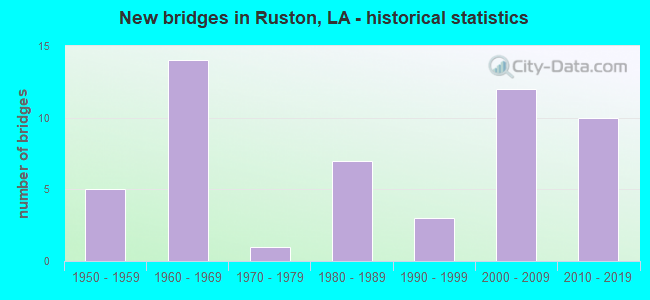
- New bridges - historical statistics
- 51950-1959
- 141960-1969
- 11970-1979
- 71980-1989
- 31990-1999
- 122000-2009
- 102010-2019
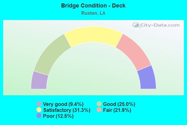
- Bridge Condition - Deck
- 9.4%Very good
- 25.0%Good
- 31.3%Satisfactory
- 21.9%Fair
- 12.5%Poor
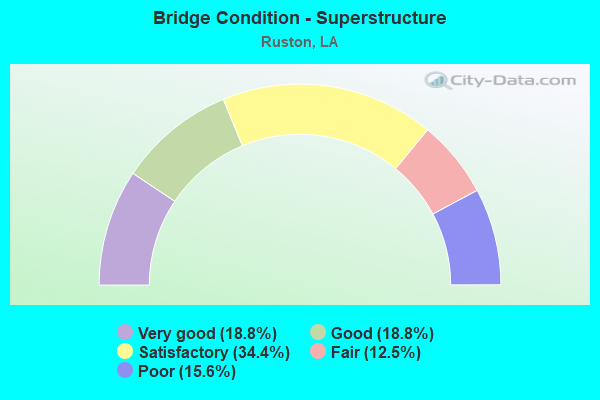
- Bridge Condition - Superstructure
- 18.8%Very good
- 18.8%Good
- 34.4%Satisfactory
- 12.5%Fair
- 15.6%Poor
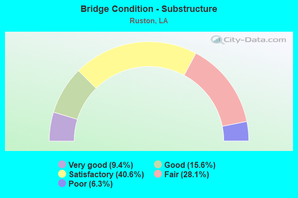
- Bridge Condition - Substructure
- 9.4%Very good
- 15.6%Good
- 40.6%Satisfactory
- 28.1%Fair
- 6.3%Poor
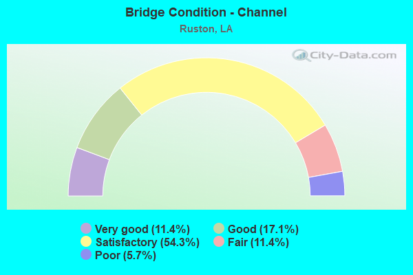
- Bridge Condition - Channel
- 11.4%Very good
- 17.1%Good
- 54.3%Satisfactory
- 11.4%Fair
- 5.7%Poor
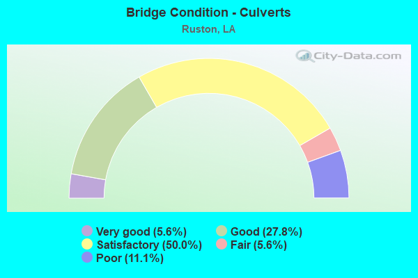
- Bridge Condition - Culverts
- 5.6%Very good
- 27.8%Good
- 50.0%Satisfactory
- 5.6%Fair
- 11.1%Poor
Find on map >> Show street view
Structure Number: 53132311923271, Location: LP 405 - HOGAN ROAD (Lat: 32.519031, Lng: -92.544700), Route carried "on" structure: County highway , Year Built: 1983, Status: Open, Structure Length: 1.19m (3.90ft), Design Load: HS 20, Features Intersected: CREEK, Facility Carried by Structure: HOGAN RD
Minimum Vertical Clearance: 30+ m (98+ ft), Kilometerpoint: 0.000, Lanes on structure: 2, Owner: County Highway Agency, Approaching Roadway Width: 8.5m (27.9ft), Material/Design: Concrete, Design/Construction: Slab, Number Of Spans In Main Unit: 2, Length of Maximum Span: 5.8m (19.0ft), Curb-To-Curb Width: 7.3m (24.0ft), Out-to-Out Width: 8.2m (26.9ft)
Condition: Deck: Good, Superstructure: Good, Substructure: Satisfactory, Channel: Satisfactory, Operating Rating: 35.3 metric tons, Method Used To Determine Operating Rating: Load and Resistance Factor Rating (LRFR) rating reported by rating factor(RF) method using HL-93 loadings, Inventory Rating: 27.2 metric tons, Method Used To Determine Inventory Rating: Load and Resistance Factor Rating (LRFR) rating reported by rating factor(RF) method using HL-93 loadings, Structural Evaluation: Equal to present minimum criteria, Deck Geometry: Equal to present minimum criteria, Waterway Adequacy: Better than present minimum criteria, Approach Roadway Alignment: Equal to present desirable criteria, Designated Inspection Frequency: Every 24 months, Inspection Date: October 2021, Deck Structure Type: Concrete Precast Panels, Wearing Surface/Protective System: Wearing Surface: Bituminous
Find on map >> Show street view
Structure Number: 53132312923421, Location: 3 MI EAST OF RUSTON (Lat: 32.531650, Lng: -92.572131), Route carried "on" structure: County highway , Year Built: 1984, Status: Open, Structure Length: 4.33m (14.21ft), Average Daily Traffic: 500 (year 1979), Average Future Daily Traffic: 850 (year 2036), Design Load: HS 20, Features Intersected: I C RAILROAD, Facility Carried by Structure: BEACON LIGHT RD
Minimum Vertical Clearance: 30+ m (98+ ft), Kilometerpoint: 0.000, Lanes on structure: 2, Owner: County Highway Agency, Approaching Roadway Width: 7.9m (25.9ft), Material/Design: Prestressed concrete, Design/Construction: Stringer/Multi-beam, Number Of Spans In Main Unit: 3, Length of Maximum Span: 18.3m (60.0ft), Curb-To-Curb Width: 8.5m (27.9ft), Out-to-Out Width: 9.4m (30.8ft)
Condition: Deck: Good, Superstructure: Very good, Substructure: Very good, Operating Rating: 44.7 metric tons, Method Used To Determine Operating Rating: Load and Resistance Factor Rating (LRFR) rating reported by rating factor(RF) method using HL-93 loadings, Inventory Rating: 35.3 metric tons, Method Used To Determine Inventory Rating: Load and Resistance Factor Rating (LRFR) rating reported by rating factor(RF) method using HL-93 loadings, Structural Evaluation: Equal to present desirable criteria, Deck Geometry: Somewhat better than minimum adequacy, Underclear: Superior to present desirable criteria, Approach Roadway Alignment: High priority of corrective action, Designated Inspection Frequency: Every 24 months, Inspection Date: November 2021, Deck Structure Type: Concrete Cast-file-Place
Find on map >> Show street view
Structure Number: 53132317923751, Location: IN RUSTON FARMERVILLE ST. (Lat: 32.528000, Lng: -92.631019), Route carried "on" structure: County highway , Year Built: 1987, Status: Open, Structure Length: 1.19m (3.90ft), Average Daily Traffic: 700 (year 1979), Average Future Daily Traffic: 1,190 (year 2036), Design Load: HS 20, Features Intersected: KANSAS CITY SOUTHERN, Facility Carried by Structure: FARMERVILLE ST
Minimum Vertical Clearance: 30+ m (98+ ft), Kilometerpoint: 0.000, Lanes on structure: 2, Owner: City or Municipal Highway Agency, Approaching Roadway Width: 8.2m (26.9ft), Material/Design: Steel, Design/Construction: Culvert, Number Of Spans In Main Unit: 1, Length of Maximum Span: 11.9m (39.0ft), Curb or Sidewalk Widths: Left: 1.3m (4.3ft), Right: 1.3m (4.3ft), Curb-To-Curb Width: 7.3m (24.0ft), Out-to-Out Width: 10.7m (35.1ft)
Condition: Culverts: Good, Operating Rating: 65.4 metric tons, Method Used To Determine Operating Rating: Load and Resistance Factor Rating (LRFR) rating reported by rating factor(RF) method using HL-93 loadings, Inventory Rating: 50.5 metric tons, Method Used To Determine Inventory Rating: Load and Resistance Factor Rating (LRFR) rating reported by rating factor(RF) method using HL-93 loadings, Structural Evaluation: Better than present minimum criteria, Deck Geometry: Meets minimum limits, Underclear: High priority of corrective action, Approach Roadway Alignment: Equal to present minimum criteria, Designated Inspection Frequency: Every 24 months, Inspection Date: November 2021
Find on map >> Show street view
Structure Number: 53132317923801, Location: BONNER ST/ RUSTON (Lat: 32.528311, Lng: -92.636881), Route carried "on" structure: County highway , Year Built: 2004, Status: Open, Structure Length: 1.28m (4.20ft), Average Daily Traffic: 6,200 (year 2002), Average Future Daily Traffic: 10,540 (year 2036), Design Load: HS 20, Features Intersected: KCS RAILROAD, Facility Carried by Structure: BONNER ST
Minimum Vertical Clearance: 30+ m (98+ ft), Kilometerpoint: 0.000, Lanes on structure: 2, Owner: City or Municipal Highway Agency, Approaching Roadway Width: 8.5m (27.9ft), Material/Design: Steel, Design/Construction: Culvert, Number Of Spans In Main Unit: 1, Length of Maximum Span: 12.8m (42.0ft), Curb or Sidewalk Widths: Left: 1.3m (4.3ft), Right: 1.3m (4.3ft), Curb-To-Curb Width: 7.3m (24.0ft), Out-to-Out Width: 11.1m (36.4ft)
Condition: Culverts: Satisfactory, Operating Rating: 46.3 metric tons, Method Used To Determine Operating Rating: Load and Resistance Factor Rating (LRFR) rating reported by rating factor(RF) method using HL-93 loadings, Inventory Rating: 36.0 metric tons, Method Used To Determine Inventory Rating: Load and Resistance Factor Rating (LRFR) rating reported by rating factor(RF) method using HL-93 loadings, Structural Evaluation: Equal to present minimum criteria, Deck Geometry: High priority of replacement, Underclear: Meets minimum limits, Approach Roadway Alignment: Equal to present minimum criteria, Length Of Structure Improvement: 1.95m (6.40ft), Designated Inspection Frequency: Every 24 months, Inspection Date: November 2021, Bridge Improvement Cost: $116,000, Roadway Improvement Cost: $11,000, Total Project Cost: $174,000 ( Estimate for 2016)
Find on map >> Show street view
Structure Number: 53132317923851, Location: EVERETT SR / RUSTON (Lat: 32.529089, Lng: -92.646331), Route carried "on" structure: County highway , Year Built: 1987, Status: Open, Structure Length: 2.93m (9.61ft), Average Daily Traffic: 5,040 (year 1986), Average Future Daily Traffic: 8,568 (year 2036), Design Load: HS 20, Features Intersected: KANSAS CITY SOUTHERN, Facility Carried by Structure: EVERETT ST
Minimum Vertical Clearance: 30+ m (98+ ft), Kilometerpoint: 0.000, Lanes on structure: 2, Owner: City or Municipal Highway Agency, Approaching Roadway Width: 8.2m (26.9ft), Material/Design: Steel, Design/Construction: Stringer/Multi-beam, Number Of Spans In Main Unit: 3, Length of Maximum Span: 14.0m (45.9ft), Curb or Sidewalk Widths: Left: 1.5m (4.9ft), Right: 1.5m (4.9ft), Curb-To-Curb Width: 7.3m (24.0ft), Out-to-Out Width: 11.0m (36.1ft)
Condition: Deck: Good, Superstructure: Good, Substructure: Satisfactory, Operating Rating: 44.4 metric tons, Method Used To Determine Operating Rating: Load and Resistance Factor Rating (LRFR) rating reported by rating factor(RF) method using HL-93 loadings, Inventory Rating: 24.0 metric tons, Method Used To Determine Inventory Rating: Load and Resistance Factor Rating (LRFR) rating reported by rating factor(RF) method using HL-93 loadings, Structural Evaluation: Somewhat better than minimum adequacy, Deck Geometry: High priority of replacement, Underclear: High priority of replacement, Approach Roadway Alignment: Equal to present minimum criteria, Length Of Structure Improvement: 3.75m (12.30ft), Designated Inspection Frequency: Every 24 months, Inspection Date: November 2021, Bridge Improvement Cost: $223,000, Roadway Improvement Cost: $22,000, Total Project Cost: $334,000 ( Estimate for 2016), Deck Structure Type: Concrete Precast Panels
Find on map >> Show street view
Structure Number: 53132327924061, Location: 0.7 MI SE of LA 544 (Lat: 32.547181, Lng: -92.677211), Route carried "on" structure: County highway , Year Built: 2005, Status: Open, Structure Length: 0.73m (2.40ft), Average Daily Traffic: 675 (year 2016), Average Future Daily Traffic: 1,147 (year 2036), Design Load: HS 20, Features Intersected: BRANCH OF CYPRESS CREEK, Facility Carried by Structure: TARBUTTON RD
Minimum Vertical Clearance: 30+ m (98+ ft), Kilometerpoint: 0.000, Lanes on structure: 2, Base Highway Network: Yes, Owner: County Highway Agency, Approaching Roadway Width: 6.1m (20.0ft), Material/Design: Steel, Design/Construction: Culvert, Number Of Spans In Main Unit: 1, Length of Maximum Span: 7.3m (24.0ft)
Condition: Channel: Fair, Culverts: Fair, Operating Rating: 78.1 metric tons, Method Used To Determine Operating Rating: Load and Resistance Factor Rating (LRFR) rating reported by rating factor(RF) method using HL-93 loadings, Inventory Rating: 59.9 metric tons, Method Used To Determine Inventory Rating: Load and Resistance Factor Rating (LRFR) rating reported by rating factor(RF) method using HL-93 loadings, Structural Evaluation: Somewhat better than minimum adequacy, Waterway Adequacy: Equal to present minimum criteria, Approach Roadway Alignment: Equal to present minimum criteria, Designated Inspection Frequency: Every 24 months, Inspection Date: September 2021
Find on map >> Show street view
Structure Number: 53132334923761, Location: CEDAR CREEK RD/ RUSTON (Lat: 32.555039, Lng: -92.625181), Route carried "on" structure: County highway , Year Built: 1975, Status: Posted for load, Structure Length: 1.19m (3.90ft), Average Daily Traffic: 325 (year 1979), Average Future Daily Traffic: 552 (year 2036), Design Load: H 20, Features Intersected: COLVIN CREEK, Facility Carried by Structure: CEDAR CREEK RD
Minimum Vertical Clearance: 30+ m (98+ ft), Kilometerpoint: 0.000, Lanes on structure: 2, Owner: City or Municipal Highway Agency, Approaching Roadway Width: 7.9m (25.9ft), Material/Design: Wood or Timber, Design/Construction: Stringer/Multi-beam, Number Of Spans In Main Unit: 2, Length of Maximum Span: 5.8m (19.0ft), Curb-To-Curb Width: 6.9m (22.6ft), Out-to-Out Width: 7.7m (25.3ft)
Condition: Deck: Fair, Superstructure: Satisfactory, Substructure: Fair, Channel: Fair, Operating Rating: 28.1 metric tons, Method Used To Determine Operating Rating: Allowable Stress (AS), Inventory Rating: 20.0 metric tons, Method Used To Determine Inventory Rating: Allowable Stress (AS), Structural Evaluation: Somewhat better than minimum adequacy, Deck Geometry: Meets minimum limits, Waterway Adequacy: Better than present minimum criteria, Approach Roadway Alignment: Equal to present minimum criteria, Length Of Structure Improvement: 1.83m (6.00ft), Designated Inspection Frequency: Every 24 months, Inspection Date: November 2021, Bridge Improvement Cost: $109,000, Total Project Cost: $163,000 ( Estimate for 2016), Deck Structure Type: Wood or Timber, Wearing Surface/Protective System: Wearing Surface: Bituminous
Find on map >> Show street view
Structure Number: 53132342923751, Location: 1.3 MI NE of US 167 (Lat: 32.573031, Lng: -92.624969), Route carried "on" structure: County highway , Year Built: 2005, Status: Open, Structure Length: 1.83m (6.00ft), Average Daily Traffic: 900 (year 2016), Average Future Daily Traffic: 1,530 (year 2036), Design Load: HS 20, Features Intersected: CURLY CREEK, Facility Carried by Structure: FRAZIER RD
Minimum Vertical Clearance: 30+ m (98+ ft), Kilometerpoint: 0.000, Lanes on structure: 2, Base Highway Network: Yes, Owner: County Highway Agency, Approaching Roadway Width: 9.1m (29.9ft), Material/Design: Concrete, Design/Construction: Slab, Number Of Spans In Main Unit: 3, Length of Maximum Span: 6.1m (20.0ft), Curb-To-Curb Width: 8.5m (27.9ft), Out-to-Out Width: 9.3m (30.5ft)
Condition: Deck: Good, Superstructure: Good, Substructure: Satisfactory, Channel: Satisfactory, Operating Rating: 41.1 metric tons, Method Used To Determine Operating Rating: Load and Resistance Factor Rating (LRFR) rating reported by rating factor(RF) method using HL-93 loadings, Inventory Rating: 31.8 metric tons, Method Used To Determine Inventory Rating: Load and Resistance Factor Rating (LRFR) rating reported by rating factor(RF) method using HL-93 loadings, Structural Evaluation: Equal to present minimum criteria, Deck Geometry: Somewhat better than minimum adequacy, Waterway Adequacy: Better than present minimum criteria, Approach Roadway Alignment: Better than present minimum criteria, Designated Inspection Frequency: Every 24 months, Inspection Date: October 2021, Deck Structure Type: Concrete Cast-file-Place
Find on map >> Show street view
Structure Number: 54200000050024, Location: 0.2 Mi. E of LA 183 (Lat: 32.500550, Lng: -91.623889), Route carried "on" structure: County highway , Year Built: 2017, Status: Open, Structure Length: 0.73m (2.40ft), Average Daily Traffic: 25 (year 2003), Average Future Daily Traffic: 28 (year 2026), Design Load: HS 20, Features Intersected: East Fork Creek, Facility Carried by Structure: O.M. Walker Rd
Minimum Vertical Clearance: 30+ m (98+ ft), Kilometerpoint: 0.325, Lanes on structure: 2, Owner: County Highway Agency, Approaching Roadway Width: 4.3m (14.1ft), Material/Design: Steel, Design/Construction: Culvert, Number Of Spans In Main Unit: 2, Length of Maximum Span: 3.0m (9.8ft), Out-to-Out Width: 11.6m (38.1ft)
Condition: Channel: Good, Culverts: Good, Operating Rating: 97.2 metric tons, Method Used To Determine Operating Rating: Load and Resistance Factor Rating (LRFR) rating reported by rating factor(RF) method using HL-93 loadings, Inventory Rating: 74.5 metric tons, Method Used To Determine Inventory Rating: Load and Resistance Factor Rating (LRFR) rating reported by rating factor(RF) method using HL-93 loadings, Structural Evaluation: Better than present minimum criteria, Waterway Adequacy: Equal to present minimum criteria, Approach Roadway Alignment: Equal to present desirable criteria, Designated Inspection Frequency: Every 24 months, Inspection Date: July 2021
Find on map >> Show street view
Structure Number: 54200000050211, Location: 0.04 MI. N. OF LA 150 (Lat: 32.540231, Lng: -92.677950), Route carried "on" structure: County highway , Year Built: 2019, Status: Open, Structure Length: 8.38m (27.49ft), Average Daily Traffic: 4,475 (year 2015), Truck Traffic: 2%, Average Future Daily Traffic: 8,131 (year 2035), Design Load: Greater than HL93, Features Intersected: 1-20, Facility Carried by Structure: TARBUTTON ROAD
Minimum Vertical Clearance: 30+ m (98+ ft), Kilometerpoint: 19.145, Lanes on structure: 4, Lanes under structure: 4, Base Highway Network: Yes (Inventory Route: 451-05-1, Subroute: 10), Owner: State Highway Agency, Approaching Roadway Width: 22.4m (73.5ft), Skew: 20 degrees, Material/Design: Steel, Design/Construction: Stringer/Multi-beam, Number Of Spans In Main Unit: 2, Length of Maximum Span: 42.1m (138.1ft), Curb-To-Curb Width: 21.3m (69.9ft), Out-to-Out Width: 23.3m (76.4ft)
Condition: Deck: Good, Superstructure: Very good, Substructure: Good, Operating Rating: 59.6 metric tons, Method Used To Determine Operating Rating: Load and Resistance Factor Rating (LRFR) rating reported by rating factor(RF) method using HL-93 loadings, Inventory Rating: 46.0 metric tons, Method Used To Determine Inventory Rating: Load and Resistance Factor Rating (LRFR) rating reported by rating factor(RF) method using HL-93 loadings, Structural Evaluation: Better than present minimum criteria, Deck Geometry: Superior to present desirable criteria, Underclear: Superior to present desirable criteria, Approach Roadway Alignment: Better than present minimum criteria, Designated Inspection Frequency: Every 24 months, Inspection Date: December 2021, Deck Structure Type: Concrete Cast-file-Place
Find on map >> Show street view
Structure Number: 53100000050178, Location: 0.73 MI E OF US 63 (Lat: 32.540139, Lng: -92.625519), Route carried "under" structure: Interstate 20, Structure Length: 0. m, Average Daily Traffic: 20,550 (year 2017), Features Intersected: I-20 EB UNDER EAGLE DR.
Minimum Vertical Clearance: 5.09m (16.70ft), Kilometerpoint: 24.065, Lanes on structure: 2, Lanes under structure: 2, Length of Maximum Span: 0.0m
Find on map >> Show street view
Structure Number: 53100000050178, Location: 0.73 MI E OF US 63 (Lat: 32.540381, Lng: -92.625331), Route carried "under" structure: Interstate 20, Structure Length: 0. m, Average Daily Traffic: 20,550 (year 2017), Features Intersected: I-20 WB UNDER EAGLE DR.
Minimum Vertical Clearance: 5.00m (16.40ft), Kilometerpoint: 19.919, Lanes on structure: 2, Lanes under structure: 2, Length of Maximum Span: 0.0m
Find on map >> Show street view
Structure Number: 53100000050211, Location: 2.0 MI. E OF LA 149 (Lat: 32.540461, Lng: -92.677950), Route carried "under" structure: Interstate 20, Year Built: 2019, Structure Length: 0. m, Average Daily Traffic: 21,850 (year 2019), Truck Traffic: 25%, Features Intersected: I-20, Facility Carried by Structure: TARBUTTON
Minimum Vertical Clearance: 5.36m (17.59ft), Kilometerpoint: 19.204, Lanes on structure: 4, Lanes under structure: 2, Length of Maximum Span: 23.2m (76.1ft)
Find on map >> Show street view
Structure Number: 53100000050211, Location: 1.4 MI. W OF LA 544 (Lat: 32.540711, Lng: -92.677931), Route carried "under" structure: Interstate 20, Year Built: 2019, Structure Length: 0. m, Average Daily Traffic: 21,850 (year 2019), Truck Traffic: 25%, Features Intersected: I-20, Facility Carried by Structure: TARBUTTON RD
Minimum Vertical Clearance: 5.27m (17.29ft), Kilometerpoint: 24.795, Lanes on structure: 4, Lanes under structure: 2, Length of Maximum Span: 23.2m (76.1ft)
Find on map >> Show street view
Structure Number: 53100231000581, Location: 1.2 MI W OF LA 33 (Lat: 32.540069, Lng: -92.638019), Route carried "under" structure: Interstate 20, Structure Length: 0. m, Average Daily Traffic: 37,600 (year 2014), Features Intersected: US 167 SB OVER I-20WB
Minimum Vertical Clearance: 5.06m (16.60ft), Kilometerpoint: 21.103, Lanes on structure: 2, Length of Maximum Span: 0.0m
Find on map >> Show street view
Structure Number: 53100231000581, Location: 1.2 MI W OF LA 33 (Lat: 32.540069, Lng: -92.638019), Route carried "under" structure: Interstate 20, Structure Length: 0. m, Average Daily Traffic: 37,600 (year 2014), Features Intersected: US 167 SB OVER I-20 EB
Minimum Vertical Clearance: 5.09m (16.70ft), Kilometerpoint: 22.901, Lanes on structure: 2, Length of Maximum Span: 0.0m
Find on map >> Show street view
Structure Number: 53100231000582, Location: 1.29 MI W OF LA 33 (Lat: 32.540311, Lng: -92.639089), Route carried "under" structure: Interstate 20, Structure Length: 0. m, Average Daily Traffic: 37,600 (year 2014), Features Intersected: US 167 NB OVER I-20WB
Minimum Vertical Clearance: 5.15m (16.90ft), Kilometerpoint: 21.227, Lanes on structure: 2, Length of Maximum Span: 0.0m
Find on map >> Show street view
Structure Number: 53100231000582, Location: 1.29 MI W OF LA 33 (Lat: 32.540311, Lng: -92.639089), Route carried "under" structure: Interstate 20, Structure Length: 0. m, Average Daily Traffic: 37,600 (year 2014), Features Intersected: US 167 NB OVER I-20EB
Minimum Vertical Clearance: 5.21m (17.09ft), Kilometerpoint: 22.777, Lanes on structure: 2, Length of Maximum Span: 0.0m
Find on map >> Show street view
Structure Number: 53100690100601, Location: 1.22 MI E OF US 167 (Lat: 32.540400, Lng: -92.616269), Route carried "under" structure: Interstate 20, Structure Length: 0. m, Average Daily Traffic: 36,000 (year 2014), Features Intersected: I-20 UNDER LA 33
Minimum Vertical Clearance: 5.12m (16.80ft), Kilometerpoint: 19.068, Lanes on structure: 2, Length of Maximum Span: 0.0m
Find on map >> Show street view
Structure Number: 53100690100601, Location: 1.22 MI E OF US 167 (Lat: 32.540169, Lng: -92.616811), Route carried "under" structure: Interstate 20, Structure Length: 0. m, Average Daily Traffic: 36,000 (year 2014), Features Intersected: I-20 UNDER LA 33
Minimum Vertical Clearance: 5.30m (17.39ft), Kilometerpoint: 24.885, Lanes on structure: 2, Length of Maximum Span: 0.0m
Find on map >> Show street view
Structure Number: 53102960308571, Location: 0.8 MI W OF US 167 (Lat: 32.540019, Lng: -92.653231), Route carried "under" structure: Interstate 20, Structure Length: 0. m, Average Daily Traffic: 4,900 (year 2015), Features Intersected: LA 544 OVER I-20 EB
Minimum Vertical Clearance: 5.18m (16.99ft), Kilometerpoint: 21.477, Lanes on structure: 2, Length of Maximum Span: 0.0m
Find on map >> Show street view
Structure Number: 53102960308571, Location: 0.8 MI W OF US 167 (Lat: 32.540019, Lng: -92.653231), Route carried "under" structure: Interstate 20, Structure Length: 0. m, Average Daily Traffic: 4,900 (year 2015), Features Intersected: LA 544 OVER I-20 WB
Minimum Vertical Clearance: 5.15m (16.90ft), Kilometerpoint: 22.526, Lanes on structure: 2, Length of Maximum Span: 0.0m
Find on map >> Show street view
Structure Number: 53104510517821, Location: 2.2 MI E OF LA 33 (Lat: 32.540000, Lng: -92.577811), Route carried "under" structure: Interstate 20, Structure Length: 0. m, Average Daily Traffic: 3,600 (year 2015), Features Intersected: ROUGH EDGE RD OVER I-20
Minimum Vertical Clearance: 5.21m (17.09ft), Kilometerpoint: 28.548, Lanes on structure: 2, Length of Maximum Span: 0.0m
Find on map >> Show street view
Structure Number: 53104510517821, Location: 2.2 MI E OF LA 33 (Lat: 32.540261, Lng: -92.577839), Route carried "under" structure: Interstate 20, Structure Length: 0. m, Average Daily Traffic: 3,600 (year 2015), Features Intersected: ROUGH EDGE RD OVER I-20
Minimum Vertical Clearance: 5.03m (16.50ft), Kilometerpoint: 15.458, Lanes on structure: 2, Length of Maximum Span: 0.0m
Find on map >> Show street view
Structure Number: 53104510519141, Location: 3.67 MI E OF LA 33 (Lat: 32.539719, Lng: -92.555169), Route carried "under" structure: Interstate 20, Structure Length: 0. m, Average Daily Traffic: 3,600 (year 2015), Features Intersected: CHANDLER RD OVER I-20
Minimum Vertical Clearance: 5.15m (16.90ft), Kilometerpoint: 30.674, Lanes on structure: 2, Lanes under structure: 2, Length of Maximum Span: 0.0m
Find on map >> Show street view
Structure Number: 53104510519141, Location: 3.67 MI E OF LA 33 (Lat: 32.539981, Lng: -92.555139), Route carried "under" structure: Interstate 20, Structure Length: 0. m, Average Daily Traffic: 6,666 (year 2015), Features Intersected: CHANDLER RD OVER I-20
Minimum Vertical Clearance: 5.30m (17.39ft), Kilometerpoint: 13.327, Lanes on structure: 2, Lanes under structure: 2, Length of Maximum Span: 0.0m