Bridge Statistics for Rosemont, Illinois (IL)
Condition, Traffic, Stress, Structural Evaluation, Project Costs
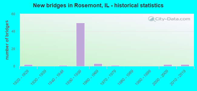
- New bridges - historical statistics
- 21920-1929
- 11940-1949
- 501950-1959
- 31960-1969
- 11970-1979
- 22000-2009
- 22010-2019

- Reconstructed bridges - Historical Statistics
- 21960-1969
- 21970-1979
- 91980-1989


- Bridge Condition - Deck
- 7.4%Very good
- 33.3%Good
- 44.4%Satisfactory
- 14.8%Fair

- Bridge Condition - Superstructure
- 14.8%Very good
- 25.9%Good
- 22.2%Satisfactory
- 25.9%Fair
- 11.1%Poor

- Bridge Condition - Substructure
- 3.7%Very good
- 48.1%Good
- 33.3%Satisfactory
- 7.4%Fair
- 3.7%Poor
- 3.7%Serious

- Bridge Condition - Channel
- 16.7%Very good
- 33.3%Good
- 41.7%Satisfactory
- 8.3%Fair

- Bridge Condition - Culverts
- 16.7%Good
- 66.7%Satisfactory
- 16.7%Fair
Find on map >> Show street view
Structure Number: 160506, Location: 0.2 M S I-90 NW TOLL (Lat: 42.002039, Lng: -87.894192), Route carried "on" structure: State highway 72, Year Built: 1940, Year Reconstructed: 1965, Status: Open, Structure Length: 1.96m (6.43ft), Average Daily Traffic: 18,300 (year 2021), Truck Traffic: 9%, Average Future Daily Traffic: 30,591 (year 2032), Design Load: HS 20, Features Intersected: WILLOW CREEK
Minimum Vertical Clearance: 30+ m (98+ ft), Kilometerpoint: 170.119, Lanes on structure: 4, Base Highway Network: Yes, Owner: State Highway Agency, Approaching Roadway Width: 17.7m (58.1ft), Skew: 30 degrees, Material/Design: Prestressed concrete, Design/Construction: Stringer/Multi-beam, Number Of Spans In Main Unit: 1, Length of Maximum Span: 17.7m (58.1ft), Curb or Sidewalk Widths: Left: 1.8m (5.9ft), Right: 1.8m (5.9ft), Curb-To-Curb Width: 16.5m (54.1ft), Out-to-Out Width: 21.3m (69.9ft)
Condition: Deck: Satisfactory, Superstructure: Satisfactory, Substructure: Good, Channel: Very good, Operating Rating: 80.7 metric tons, Method Used To Determine Operating Rating: Load Factor (LF) rating reported by rating factor (RF) method using MS18 loading, Inventory Rating: 48.3 metric tons, Method Used To Determine Inventory Rating: Load Factor (LF) rating reported by rating factor (RF) method using MS18 loading, Structural Evaluation: Equal to present minimum criteria, Deck Geometry: Meets minimum limits, Waterway Adequacy: Equal to present desirable criteria, Approach Roadway Alignment: Better than present minimum criteria, Designated Inspection Frequency: Every 24 months, Inspection Date: July 2021, Deck Structure Type: Concrete Cast-file-Place, Wearing Surface/Protective System: Wearing Surface: Latex Concrete
Find on map >> Show street view
Structure Number: 160508, Location: 3.2 M W IL 43 (Lat: 41.983181, Lng: -87.870053), Route carried "on" structure: Interstate 190, Year Built: 1959, Year Reconstructed: 1989, Status: Open, Structure Length: 7.41m (24.31ft), Average Daily Traffic: 40,100 (year 2021), Truck Traffic: 4%, Average Future Daily Traffic: 48,616 (year 2032), Design Load: HS 20, Features Intersected: I-294 TRI-STATE TOLL
Minimum Vertical Clearance: 30+ m (98+ ft), Kilometerpoint: 2.076, Lanes on structure: 3, Lanes under structure: 9, Base Highway Network: Yes, Owner: State Highway Agency, Approaching Roadway Width: 15.5m (50.9ft), Material/Design: Prestressed concrete, Design/Construction: Stringer/Multi-beam, Number Of Spans In Main Unit: 4, Length of Maximum Span: 23.8m (78.1ft), Curb-To-Curb Width: 15.6m (51.2ft), Out-to-Out Width: 16.4m (53.8ft)
Condition: Deck: Fair, Superstructure: Fair, Substructure: Satisfactory, Operating Rating: 97.2 metric tons, Method Used To Determine Operating Rating: Load Factor (LF) rating reported by rating factor (RF) method using MS18 loading, Inventory Rating: 64.2 metric tons, Method Used To Determine Inventory Rating: Load Factor (LF) rating reported by rating factor (RF) method using MS18 loading, Structural Evaluation: Somewhat better than minimum adequacy, Deck Geometry: Somewhat better than minimum adequacy, Underclear: Meets minimum limits, Approach Roadway Alignment: Equal to present desirable criteria, Designated Inspection Frequency: Every 24 months, Inspection Date: June 2020, Deck Structure Type: Concrete Cast-file-Place, Wearing Surface/Protective System: Deck Protection: Epoxy Coated Reinforcing
Find on map >> Show street view
Structure Number: 160509, Location: 3.2 M W IL 43 (Lat: 41.983175, Lng: -87.870450), Route carried "on" structure: Interstate 190, Year Built: 1959, Year Reconstructed: 1989, Status: Open, Structure Length: 7.41m (24.31ft), Average Daily Traffic: 40,100 (year 2021), Truck Traffic: 4%, Average Future Daily Traffic: 56,702 (year 2032), Design Load: HS 20, Features Intersected: I-294 TRI STATE TOLL
Minimum Vertical Clearance: 30+ m (98+ ft), Kilometerpoint: 2.092, Lanes on structure: 4, Lanes under structure: 9, Base Highway Network: Yes, Owner: State Highway Agency, Approaching Roadway Width: 24.4m (80.1ft), Skew: 1 degrees, Material/Design: Prestressed concrete, Design/Construction: Stringer/Multi-beam, Number Of Spans In Main Unit: 4, Length of Maximum Span: 25.6m (84.0ft), Curb-To-Curb Width: 19.8m (65.0ft), Out-to-Out Width: 21.0m (68.9ft)
Condition: Deck: Satisfactory, Superstructure: Fair, Substructure: Fair, Operating Rating: 97.2 metric tons, Method Used To Determine Operating Rating: Load Factor (LF) rating reported by rating factor (RF) method using MS18 loading, Inventory Rating: 64.2 metric tons, Method Used To Determine Inventory Rating: Load Factor (LF) rating reported by rating factor (RF) method using MS18 loading, Structural Evaluation: Somewhat better than minimum adequacy, Deck Geometry: Equal to present minimum criteria, Underclear: Meets minimum limits, Approach Roadway Alignment: Equal to present desirable criteria, Designated Inspection Frequency: Every 24 months, Inspection Date: June 2020, Deck Structure Type: Concrete Cast-file-Place, Wearing Surface/Protective System: Deck Protection: Epoxy Coated Reinforcing
Find on map >> Show street view
Structure Number: 16051, Location: 3.1 M W IL 43 (Lat: 41.983411, Lng: -87.856892), Route carried "on" structure: Interstate 190, Year Built: 1959, Year Reconstructed: 1989, Status: Open, Structure Length: 4.34m (14.24ft), Average Daily Traffic: 34,350 (year 2021), Truck Traffic: 3%, Average Future Daily Traffic: 58,298 (year 2032), Design Load: HS 20, Features Intersected: I-294 NB to I-90
Minimum Vertical Clearance: 30+ m (98+ ft), Kilometerpoint: 0.966, Lanes on structure: 3, Lanes under structure: 4, Base Highway Network: Yes, Owner: State Highway Agency, Approaching Roadway Width: 16.5m (54.1ft), Material/Design: Prestressed concrete, Design/Construction: Stringer/Multi-beam, Number Of Spans In Main Unit: 3, Length of Maximum Span: 14.8m (48.6ft), Curb-To-Curb Width: 16.5m (54.1ft), Out-to-Out Width: 17.4m (57.1ft)
Condition: Deck: Satisfactory, Superstructure: Fair, Substructure: Satisfactory, Operating Rating: 90.1 metric tons, Method Used To Determine Operating Rating: Load Factor (LF) rating reported by rating factor (RF) method using MS18 loading, Inventory Rating: 54.1 metric tons, Method Used To Determine Inventory Rating: Load Factor (LF) rating reported by rating factor (RF) method using MS18 loading, Structural Evaluation: Somewhat better than minimum adequacy, Deck Geometry: Equal to present minimum criteria, Underclear: High priority of corrective action, Approach Roadway Alignment: Equal to present desirable criteria, Designated Inspection Frequency: Every 24 months, Inspection Date: June 2020, Deck Structure Type: Concrete Cast-file-Place, Wearing Surface/Protective System: Deck Protection: Epoxy Coated Reinforcing
Find on map >> Show street view
Structure Number: 160511, Location: 2.8 M W IL 43 (Lat: 41.983333, Lng: -87.861778), Route carried "on" structure: Interstate 190, Year Built: 1959, Year Reconstructed: 1989, Status: Open, Structure Length: 5.48m (17.98ft), Average Daily Traffic: 32,100 (year 2021), Truck Traffic: 3%, Average Future Daily Traffic: 44,599 (year 2032), Design Load: HS 20, Features Intersected: DES PLAINES RIV RD
Minimum Vertical Clearance: 30+ m (98+ ft), Kilometerpoint: 1.384, Lanes on structure: 3, Lanes under structure: 6, Base Highway Network: Yes, Owner: State Highway Agency, Approaching Roadway Width: 16.5m (54.1ft), Skew: 1 degrees, Material/Design: Prestressed concrete, Design/Construction: Stringer/Multi-beam, Number Of Spans In Main Unit: 4, Length of Maximum Span: 15.5m (50.9ft), Curb-To-Curb Width: 16.5m (54.1ft), Out-to-Out Width: 17.4m (57.1ft)
Condition: Deck: Fair, Superstructure: Poor, Substructure: Poor, Operating Rating: 79.4 metric tons, Method Used To Determine Operating Rating: Load Factor (LF) rating reported by rating factor (RF) method using MS18 loading, Inventory Rating: 46.0 metric tons, Method Used To Determine Inventory Rating: Load Factor (LF) rating reported by rating factor (RF) method using MS18 loading, Structural Evaluation: Meets minimum limits, Deck Geometry: Equal to present minimum criteria, Underclear: Somewhat better than minimum adequacy, Approach Roadway Alignment: Equal to present desirable criteria, Designated Inspection Frequency: Every 12 months, Inspection Date: October 2021, Deck Structure Type: Concrete Cast-file-Place, Wearing Surface/Protective System: Deck Protection: Epoxy Coated Reinforcing
Find on map >> Show street view
Structure Number: 160512, Location: 2.8 M W IL 43 (Lat: 41.983339, Lng: -87.861369), Route carried "on" structure: Interstate 190, Year Built: 1959, Year Reconstructed: 1989, Status: Open, Structure Length: 5.36m (17.59ft), Average Daily Traffic: 32,100 (year 2021), Truck Traffic: 3%, Average Future Daily Traffic: 44,599 (year 2032), Design Load: HS 20, Features Intersected: DES PLAINES RIV RD
Minimum Vertical Clearance: 30+ m (98+ ft), Kilometerpoint: 1.368, Lanes on structure: 3, Lanes under structure: 6, Base Highway Network: Yes, Owner: State Highway Agency, Approaching Roadway Width: 16.5m (54.1ft), Material/Design: Prestressed concrete, Design/Construction: Stringer/Multi-beam, Number Of Spans In Main Unit: 4, Length of Maximum Span: 15.2m (49.9ft), Curb-To-Curb Width: 16.5m (54.1ft), Out-to-Out Width: 17.4m (57.1ft)
Condition: Deck: Fair, Superstructure: Poor, Substructure: Serious, Operating Rating: 82.3 metric tons, Method Used To Determine Operating Rating: Load Factor (LF) rating reported by rating factor (RF) method using MS18 loading, Inventory Rating: 48.3 metric tons, Method Used To Determine Inventory Rating: Load Factor (LF) rating reported by rating factor (RF) method using MS18 loading, Structural Evaluation: High priority of corrective action, Deck Geometry: Equal to present minimum criteria, Underclear: Somewhat better than minimum adequacy, Approach Roadway Alignment: Equal to present desirable criteria, Designated Inspection Frequency: Every 12 months, Inspection Date: October 2021, Deck Structure Type: Concrete Cast-file-Place, Wearing Surface/Protective System: Deck Protection: Epoxy Coated Reinforcing
Find on map >> Show street view
Structure Number: 160513, Location: 2.5 M W IL 43 (Lat: 41.983411, Lng: -87.856539), Route carried "on" structure: Interstate 190, Year Built: 1959, Year Reconstructed: 1987, Status: Open, Structure Length: 24.96m (81.89ft), Average Daily Traffic: 34,350 (year 2021), Truck Traffic: 3%, Average Future Daily Traffic: 58,298 (year 2032), Design Load: HS 20, Features Intersected: I- 90 TOLL & D P RIV
Minimum Vertical Clearance: 30+ m (98+ ft), Kilometerpoint: 0.933, Lanes on structure: 2, Lanes under structure: 11, Base Highway Network: Yes, Owner: State Highway Agency, Approaching Roadway Width: 12.8m (42.0ft), Skew: 1 degrees, Material/Design: Steel continuous, Design/Construction: Stringer/Multi-beam, Number Of Spans In Main Unit: 9, Length of Maximum Span: 37.9m (124.3ft), Curb-To-Curb Width: 12.8m (42.0ft), Out-to-Out Width: 13.8m (45.3ft)
Condition: Deck: Satisfactory, Superstructure: Poor, Substructure: Satisfactory, Channel: Satisfactory, Operating Rating: 48.6 metric tons, Method Used To Determine Operating Rating: Load Factor (LF) rating reported by rating factor (RF) method using MS18 loading, Inventory Rating: 29.2 metric tons, Method Used To Determine Inventory Rating: Load Factor (LF) rating reported by rating factor (RF) method using MS18 loading, Structural Evaluation: Meets minimum limits, Deck Geometry: Equal to present desirable criteria, Underclear: Meets minimum limits, Waterway Adequacy: Equal to present desirable criteria, Approach Roadway Alignment: Equal to present desirable criteria, Length Of Structure Improvement: 24.29m (79.69ft), Designated Inspection Frequency: Every 12 months, Inspection Date: June 2021, Bridge Improvement Cost: $2,416,000, Roadway Improvement Cost: $242,000, Total Project Cost: $3,624,000, Deck Structure Type: Concrete Cast-file-Place, Wearing Surface/Protective System: Deck Protection: Epoxy Coated Reinforcing
Find on map >> Show street view
Structure Number: 160514, Location: 2.5 M W IL 43 (Lat: 41.983414, Lng: -87.856383), Route carried "on" structure: Interstate 190, Year Built: 1959, Year Reconstructed: 1988, Status: Open, Structure Length: 8.00m (26.25ft), Average Daily Traffic: 34,350 (year 2021), Truck Traffic: 3%, Average Future Daily Traffic: 58,298 (year 2032), Design Load: HS 20, Features Intersected: DES PLAINES RIVER
Minimum Vertical Clearance: 30+ m (98+ ft), Kilometerpoint: 0.917, Lanes on structure: 3, Base Highway Network: Yes, Owner: State Highway Agency, Approaching Roadway Width: 15.5m (50.9ft), Material/Design: Prestressed concrete, Design/Construction: Stringer/Multi-beam, Number Of Spans In Main Unit: 4, Length of Maximum Span: 19.8m (65.0ft), Curb-To-Curb Width: 15.6m (51.2ft), Out-to-Out Width: 17.4m (57.1ft)
Condition: Deck: Satisfactory, Superstructure: Fair, Substructure: Satisfactory, Channel: Good, Operating Rating: 89.1 metric tons, Method Used To Determine Operating Rating: Load Factor (LF) rating reported by rating factor (RF) method using MS18 loading, Inventory Rating: 58.6 metric tons, Method Used To Determine Inventory Rating: Load Factor (LF) rating reported by rating factor (RF) method using MS18 loading, Structural Evaluation: Somewhat better than minimum adequacy, Deck Geometry: Somewhat better than minimum adequacy, Waterway Adequacy: Equal to present desirable criteria, Approach Roadway Alignment: Equal to present desirable criteria, Length Of Structure Improvement: 24.29m (79.69ft), Designated Inspection Frequency: Every 24 months, Inspection Date: April 2020, Bridge Improvement Cost: $2,416,000, Roadway Improvement Cost: $242,000, Total Project Cost: $3,624,000, Deck Structure Type: Concrete Cast-file-Place, Wearing Surface/Protective System: Deck Protection: Epoxy Coated Reinforcing
Find on map >> Show street view
Structure Number: 160665, Location: 0.6 M SE I-294 (Lat: 41.989203, Lng: -87.856253), Route carried "on" structure: State highway 72, Year Built: 1929, Year Reconstructed: 1980, Status: Open, Structure Length: 6.08m (19.95ft), Average Daily Traffic: 17,600 (year 2021), Truck Traffic: 3%, Average Future Daily Traffic: 24,205 (year 2032), Design Load: HS 20+Mod, Features Intersected: DES PLAINES RIVER
Minimum Vertical Clearance: 30+ m (98+ ft), Kilometerpoint: 173.756, Lanes on structure: 4, Base Highway Network: Yes, Owner: State Highway Agency, Approaching Roadway Width: 15.8m (51.8ft), Skew: 23 degrees, Material/Design: Prestressed concrete continuous, Design/Construction: Stringer/Multi-beam, Number Of Spans In Main Unit: 3, Length of Maximum Span: 19.8m (65.0ft), Curb or Sidewalk Widths: Left: 1.5m (4.9ft), Right: 1.5m (4.9ft), Curb-To-Curb Width: 18.9m (62.0ft), Out-to-Out Width: 22.6m (74.1ft)
Condition: Deck: Satisfactory, Superstructure: Good, Substructure: Good, Channel: Satisfactory, Operating Rating: 52.5 metric tons, Method Used To Determine Operating Rating: Load Factor (LF) rating reported by rating factor (RF) method using MS18 loading, Inventory Rating: 31.4 metric tons, Method Used To Determine Inventory Rating: Load Factor (LF) rating reported by rating factor (RF) method using MS18 loading, Structural Evaluation: Better than present minimum criteria, Deck Geometry: Equal to present minimum criteria, Waterway Adequacy: Equal to present desirable criteria, Approach Roadway Alignment: Better than present minimum criteria, Length Of Structure Improvement: 6.13m (20.11ft), Designated Inspection Frequency: Every 24 months, Inspection Date: September 2020, Bridge Improvement Cost: $1,071,000, Roadway Improvement Cost: $107,000, Total Project Cost: $1,607,000, Deck Structure Type: Concrete Cast-file-Place, Wearing Surface/Protective System: Wearing Surface: Latex Concrete
Find on map >> Show street view
Structure Number: 161091, Location: 3.1 M W IL 43 (Lat: 41.983242, Lng: -87.866853), Route carried "on" structure: Interstate 190, Year Built: 1959, Year Reconstructed: 1989, Status: Open, Structure Length: 4.14m (13.58ft), Average Daily Traffic: 32,550 (year 2021), Truck Traffic: 4%, Average Future Daily Traffic: 48,616 (year 2032), Design Load: HS 20, Features Intersected: I-294 NB to I-90
Minimum Vertical Clearance: 30+ m (98+ ft), Kilometerpoint: 1.851, Lanes on structure: 4, Lanes under structure: 6, Base Highway Network: Yes, Owner: State Highway Agency, Approaching Roadway Width: 21.3m (69.9ft), Material/Design: Prestressed concrete, Design/Construction: Stringer/Multi-beam, Number Of Spans In Main Unit: 3, Length of Maximum Span: 14.5m (47.6ft), Curb-To-Curb Width: 21.3m (69.9ft), Out-to-Out Width: 22.3m (73.2ft)
Condition: Deck: Fair, Superstructure: Fair, Substructure: Fair, Operating Rating: 92.3 metric tons, Method Used To Determine Operating Rating: Load Factor (LF) rating reported by rating factor (RF) method using MS18 loading, Inventory Rating: 55.4 metric tons, Method Used To Determine Inventory Rating: Load Factor (LF) rating reported by rating factor (RF) method using MS18 loading, Structural Evaluation: Somewhat better than minimum adequacy, Deck Geometry: Better than present minimum criteria, Underclear: High priority of corrective action, Approach Roadway Alignment: Equal to present desirable criteria, Designated Inspection Frequency: Every 24 months, Inspection Date: June 2020, Deck Structure Type: Concrete Cast-file-Place, Wearing Surface/Protective System: Deck Protection: Epoxy Coated Reinforcing
Find on map >> Show street view
Structure Number: 162447, Location: 0.6 M W RIVER RD P9 (Lat: 41.983556, Lng: -87.871869), Route carried "on" structure: Other road , Year Built: 1960, Year Reconstructed: 1981, Status: Open, Structure Length: 5.67m (18.60ft), Average Daily Traffic: 15,700 (year 2021), Average Future Daily Traffic: 16,892 (year 2032), Design Load: HS 20, Features Intersected: I-190 EB JFK, Facility Carried by Structure: I-294 OFF RAMP
Minimum Vertical Clearance: 30+ m (98+ ft), Kilometerpoint: 0.177, Lanes on structure: 1, Lanes under structure: 6, Base Highway Network: Yes, Owner: State Toll Authority, Approaching Roadway Width: 8.5m (27.9ft), Material/Design: Prestressed concrete, Design/Construction: Stringer/Multi-beam, Number Of Spans In Main Unit: 4, Length of Maximum Span: 18.7m (61.4ft), Curb-To-Curb Width: 11.0m (36.1ft), Out-to-Out Width: 11.9m (39.0ft)
Condition: Deck: Good, Superstructure: Good, Substructure: Satisfactory, Operating Rating: 78.4 metric tons, Method Used To Determine Operating Rating: Load Factor (LF) rating reported by rating factor (RF) method using MS18 loading, Inventory Rating: 47.0 metric tons, Method Used To Determine Inventory Rating: Load Factor (LF) rating reported by rating factor (RF) method using MS18 loading, Structural Evaluation: Equal to present minimum criteria, Deck Geometry: Meets minimum limits, Underclear: High priority of corrective action, Approach Roadway Alignment: Better than present minimum criteria, Designated Inspection Frequency: Every 24 months, Inspection Date: June 2020, Deck Structure Type: Concrete Cast-file-Place, Wearing Surface/Protective System: Wearing Surface: Other, Deck Protection: Epoxy Coated Reinforcing
Find on map >> Show street view
Structure Number: 162501, Location: 0.1 M S ILL 72 P9 (Lat: 41.990142, Lng: -87.859939), Route carried "on" structure: Other road , Year Built: 1929, Year Reconstructed: 1978, Status: Open, Structure Length: 1.34m (4.40ft), Average Daily Traffic: 18,250 (year 2018), Truck Traffic: 7%, Average Future Daily Traffic: 32,445 (year 2032), Design Load: HS 20, Features Intersected: WILLOW CR, Facility Carried by Structure: RIVER RD
Minimum Vertical Clearance: 30+ m (98+ ft), Kilometerpoint: 6.502, Lanes on structure: 4, Base Highway Network: Yes, Owner: City or Municipal Highway Agency, Approaching Roadway Width: 27.3m (89.6ft), Material/Design: Concrete, Design/Construction: Culvert, Number Of Spans In Main Unit: 3, Length of Maximum Span: 4.3m (14.1ft), Curb or Sidewalk Widths: Left: 3.2m (10.5ft), Right: 2.1m (6.9ft), Curb-To-Curb Width: 27.3m (89.6ft), Out-to-Out Width: 35.1m (115.2ft)
Condition: Channel: Good, Culverts: Good, Operating Rating: 54.1 metric tons, Method Used To Determine Operating Rating: Field evaluation and documented engineering judgment, Inventory Rating: 32.4 metric tons, Method Used To Determine Inventory Rating: Field evaluation and documented engineering judgment, Structural Evaluation: Better than present minimum criteria, Deck Geometry: Superior to present desirable criteria, Waterway Adequacy: High priority of corrective action, Approach Roadway Alignment: Equal to present desirable criteria, Designated Inspection Frequency: Every 24 months, Inspection Date: November 2021
Find on map >> Show street view
Structure Number: 162742, Location: 0.25 Mi S of I-90 (Lat: 41.987858, Lng: -87.869422), Route carried "on" structure: Other road , Year Built: 1959, Status: Open, Structure Length: 1.39m (4.56ft), Average Daily Traffic: 10,900 (year 2020), Average Future Daily Traffic: 22,042 (year 2032), Design Load: HS 20, Features Intersected: Willow Creek, Facility Carried by Structure: I-90E/294S to I-19
Minimum Vertical Clearance: 30+ m (98+ ft), Kilometerpoint: 0.290, Lanes on structure: 2, Base Highway Network: Yes (Inventory Route: 10294041, Subroute: 70), Toll: On toll road, Owner: State Toll Authority, Approaching Roadway Width: 17.4m (57.1ft), Material/Design: Concrete, Design/Construction: Culvert, Number Of Spans In Main Unit: 2, Length of Maximum Span: 6.1m (20.0ft)
Condition: Channel: Good, Culverts: Satisfactory, Operating Rating: 40.5 metric tons, Method Used To Determine Operating Rating: Load Factor (LF) rating reported by rating factor (RF) method using MS18 loading, Inventory Rating: 33.0 metric tons, Method Used To Determine Inventory Rating: Load Factor (LF) rating reported by rating factor (RF) method using MS18 loading, Structural Evaluation: Equal to present minimum criteria, Waterway Adequacy: Superior to present desirable criteria, Approach Roadway Alignment: Superior to present desirable criteria, Designated Inspection Frequency: Every 24 months, Inspection Date: April 2021, Deck Structure Type: Concrete Cast-file-Place
Find on map >> Show street view
Structure Number: 162743, Location: 0.20 Mi S I-90 (Lat: 41.987889, Lng: -87.868514), Route carried "on" structure: Interstate 294, Year Built: 1959, Status: Open, Structure Length: 1.39m (4.56ft), Average Daily Traffic: 112,600 (year 2020), Truck Traffic: 14%, Average Future Daily Traffic: 62,933 (year 2032), Design Load: HS 20, Features Intersected: Willow Creek
Minimum Vertical Clearance: 30+ m (98+ ft), Kilometerpoint: 19.971, Lanes on structure: 7, Base Highway Network: Yes, Toll: On toll road, Owner: State Toll Authority, Approaching Roadway Width: 46.3m (151.9ft), Skew: 1 degrees, Material/Design: Concrete, Design/Construction: Culvert, Number Of Spans In Main Unit: 2, Length of Maximum Span: 6.1m (20.0ft)
Condition: Channel: Satisfactory, Culverts: Satisfactory, Operating Rating: 75.5 metric tons, Method Used To Determine Operating Rating: Load Factor (LF) rating reported by rating factor (RF) method using MS18 loading, Inventory Rating: 45.4 metric tons, Method Used To Determine Inventory Rating: Load Factor (LF) rating reported by rating factor (RF) method using MS18 loading, Structural Evaluation: Equal to present minimum criteria, Waterway Adequacy: Superior to present desirable criteria, Approach Roadway Alignment: Superior to present desirable criteria, Designated Inspection Frequency: Every 24 months, Inspection Date: April 2021, Deck Structure Type: Concrete Cast-file-Place
Find on map >> Show street view
Structure Number: 166342, Location: 0.40 MI E of I-294 (Lat: 41.986628, Lng: -87.860972), Route carried "on" structure: Interstate 90, Year Built: 2006, Status: Open, Structure Length: 3.51m (11.52ft), Average Daily Traffic: 85,000 (year 2021), Truck Traffic: 4%, Average Future Daily Traffic: 22,248 (year 2032), Design Load: HS 20, Features Intersected: Des Plaines River Rd
Minimum Vertical Clearance: 30+ m (98+ ft), Kilometerpoint: 126.121, Lanes on structure: 3, Lanes under structure: 4, Base Highway Network: Yes, Toll: On toll road, Owner: State Toll Authority, Approaching Roadway Width: 16.5m (54.1ft), Skew: 2 degrees, Material/Design: Steel, Design/Construction: Stringer/Multi-beam, Number Of Spans In Main Unit: 1, Length of Maximum Span: 33.2m (108.9ft), Curb-To-Curb Width: 16.5m (54.1ft), Out-to-Out Width: 17.4m (57.1ft)
Condition: Deck: Good, Superstructure: Good, Substructure: Good, Operating Rating: 75.8 metric tons, Method Used To Determine Operating Rating: Load Factor (LF) rating reported by rating factor (RF) method using MS18 loading, Inventory Rating: 45.4 metric tons, Method Used To Determine Inventory Rating: Load Factor (LF) rating reported by rating factor (RF) method using MS18 loading, Structural Evaluation: Better than present minimum criteria, Deck Geometry: Equal to present minimum criteria, Underclear: Meets minimum limits, Approach Roadway Alignment: Equal to present desirable criteria, Designated Inspection Frequency: Every 24 months, Inspection Date: May 2019, Deck Structure Type: Concrete Cast-file-Place
Find on map >> Show street view
Structure Number: 16794, Location: 0.4 M E US 45 P9 (Lat: 41.988856, Lng: -87.871011), Route carried "on" structure: City street , Year Built: 1972, Status: Open, Structure Length: 1.58m (5.18ft), Average Daily Traffic: 400 (year 2018), Truck Traffic: 6%, Average Future Daily Traffic: 215 (year 2032), Features Intersected: WILLOW CR, Facility Carried by Structure: RUBY ST
Minimum Vertical Clearance: 30+ m (98+ ft), Kilometerpoint: 0.306, Lanes on structure: 2, Owner: City or Municipal Highway Agency, Approaching Roadway Width: 7.3m (24.0ft), Material/Design: Concrete, Design/Construction: Culvert, Number Of Spans In Main Unit: 4, Length of Maximum Span: 4.0m (13.1ft), Curb or Sidewalk Widths: Left: 1.1m (3.6ft), Right: 1.1m (3.6ft), Curb-To-Curb Width: 7.3m (24.0ft), Out-to-Out Width: 11.0m (36.1ft)
Condition: Channel: Satisfactory, Culverts: Satisfactory, Operating Rating: 54.1 metric tons, Method Used To Determine Operating Rating: Field evaluation and documented engineering judgment, Inventory Rating: 32.4 metric tons, Method Used To Determine Inventory Rating: Field evaluation and documented engineering judgment, Structural Evaluation: Equal to present minimum criteria, Deck Geometry: Somewhat better than minimum adequacy, Waterway Adequacy: Better than present minimum criteria, Approach Roadway Alignment: Better than present minimum criteria, Designated Inspection Frequency: Every 24 months, Inspection Date: August 2020, Deck Structure Type: Concrete Cast-file-Place, Wearing Surface/Protective System: Wearing Surface: Integral Concrete
Find on map >> Show street view
Structure Number: 167941, Location: 0.1 M W RIVER RD P9 (Lat: 41.989900, Lng: -87.862036), Route carried "on" structure: City street , Year Built: 1969, Status: Open, Structure Length: 2.23m (7.32ft), Average Daily Traffic: 1,450 (year 2018), Truck Traffic: 8%, Average Future Daily Traffic: 215 (year 2032), Design Load: HS 20, Features Intersected: WILLOW CR, Facility Carried by Structure: GLEN LAKE DR
Minimum Vertical Clearance: 30+ m (98+ ft), Kilometerpoint: 0.370, Lanes on structure: 2, Owner: City or Municipal Highway Agency, Approaching Roadway Width: 8.5m (27.9ft), Skew: 4 degrees, Material/Design: Concrete, Design/Construction: Culvert, Number Of Spans In Main Unit: 5, Length of Maximum Span: 4.3m (14.1ft), Curb or Sidewalk Widths: Left: 0.6m (2.0ft), Right: 0.6m (2.0ft), Curb-To-Curb Width: 8.3m (27.2ft), Out-to-Out Width: 9.5m (31.2ft)
Condition: Channel: Fair, Culverts: Fair, Operating Rating: 43.1 metric tons, Method Used To Determine Operating Rating: Field evaluation and documented engineering judgment, Inventory Rating: 25.9 metric tons, Method Used To Determine Inventory Rating: Field evaluation and documented engineering judgment, Structural Evaluation: Somewhat better than minimum adequacy, Deck Geometry: Meets minimum limits, Waterway Adequacy: Equal to present desirable criteria, Approach Roadway Alignment: Equal to present minimum criteria, Designated Inspection Frequency: Every 24 months, Inspection Date: August 2020, Deck Structure Type: Concrete Cast-file-Place, Wearing Surface/Protective System: Wearing Surface: Bituminous, Membrane: Built-up
Find on map >> Show street view
Structure Number: 169611, Location: 0.6 Mi E. Lee St. (Lat: 42.001114, Lng: -87.884753), Route carried "on" structure: Interstate 90, Year Built: 2015, Status: Open, Structure Length: 3.92m (12.86ft), Average Daily Traffic: 141,200 (year 2020), Truck Traffic: 9%, Average Future Daily Traffic: 84,563 (year 2032), Design Load: HS 25 or greater, Features Intersected: US 12-45
Minimum Vertical Clearance: 30+ m (98+ ft), Kilometerpoint: 123.562, Lanes on structure: 5, Lanes under structure: 4, Base Highway Network: Yes, Toll: On toll road, Owner: State Toll Authority, Approaching Roadway Width: 27.4m (89.9ft), Skew: 3 degrees, Material/Design: Prestressed concrete, Design/Construction: Stringer/Multi-beam, Number Of Spans In Main Unit: 1, Length of Maximum Span: 37.8m (124.0ft), Curb-To-Curb Width: 27.4m (89.9ft), Out-to-Out Width: 28.4m (93.2ft)
Condition: Deck: Good, Superstructure: Very good, Substructure: Very good, Operating Rating: 63.2 metric tons, Method Used To Determine Operating Rating: Load and Resistance Factor Rating (LRFR) rating reported by rating factor(RF) method using HL-93 loadings, Inventory Rating: 46.7 metric tons, Method Used To Determine Inventory Rating: Load and Resistance Factor Rating (LRFR) rating reported by rating factor(RF) method using HL-93 loadings, Structural Evaluation: Equal to present desirable criteria, Deck Geometry: Superior to present desirable criteria, Approach Roadway Alignment: Equal to present desirable criteria, Designated Inspection Frequency: Every 24 months, Inspection Date: May 2019, Deck Structure Type: Concrete Cast-file-Place, Wearing Surface/Protective System: Deck Protection: Epoxy Coated Reinforcing
Find on map >> Show street view
Structure Number: 169774, Location: 0.7 M N I190 P9 (Lat: 41.993583, Lng: -87.866522), Route carried "on" structure: Interstate 294, Year Built: 1958, Status: Open, Structure Length: 2.16m (7.09ft), Average Daily Traffic: 84,400 (year 2020), Truck Traffic: 12%, Average Future Daily Traffic: 102,331 (year 2032), Features Intersected: ILL 72 (HIGGINS RD)
Minimum Vertical Clearance: 30+ m (98+ ft), Kilometerpoint: 19.279, Lanes on structure: 4, Lanes under structure: 4, Base Highway Network: Yes, Toll: On toll road, Owner: State Toll Authority, Approaching Roadway Width: 15.8m (51.8ft), Material/Design: Prestressed concrete, Design/Construction: Stringer/Multi-beam, Number Of Spans In Main Unit: 1, Length of Maximum Span: 20.7m (67.9ft), Curb-To-Curb Width: 27.9m (91.5ft), Out-to-Out Width: 30.5m (100.1ft)
Condition: Deck: Satisfactory, Superstructure: Satisfactory, Substructure: Good, Operating Rating: 89.1 metric tons, Method Used To Determine Operating Rating: Load Factor (LF) rating reported by rating factor (RF) method using MS18 loading, Inventory Rating: 59.6 metric tons, Method Used To Determine Inventory Rating: Load Factor (LF) rating reported by rating factor (RF) method using MS18 loading, Structural Evaluation: Equal to present minimum criteria, Deck Geometry: Superior to present desirable criteria, Underclear: Meets minimum limits, Approach Roadway Alignment: Equal to present desirable criteria, Designated Inspection Frequency: Every 24 months, Inspection Date: April 2021, Deck Structure Type: Concrete Cast-file-Place, Wearing Surface/Protective System: Wearing Surface: Bituminous
Find on map >> Show street view
Structure Number: 169775, Location: 0.7 M N I190 P9 (Lat: 41.993347, Lng: -87.866606), Route carried "on" structure: Interstate 294, Year Built: 1958, Status: Open, Structure Length: 2.16m (7.09ft), Average Daily Traffic: 74,500 (year 2020), Truck Traffic: 14%, Average Future Daily Traffic: 78,023 (year 2032), Features Intersected: ILL 72 (HIGGINS RD)
Minimum Vertical Clearance: 30+ m (98+ ft), Kilometerpoint: 19.312, Lanes on structure: 3, Lanes under structure: 4, Base Highway Network: Yes, Toll: On toll road, Owner: State Toll Authority, Approaching Roadway Width: 15.8m (51.8ft), Material/Design: Prestressed concrete, Number Of Spans In Main Unit: 1, Length of Maximum Span: 20.7m (67.9ft), Curb-To-Curb Width: 22.1m (72.5ft), Out-to-Out Width: 23.5m (77.1ft)
Condition: Deck: Satisfactory, Superstructure: Satisfactory, Substructure: Good, Operating Rating: 70.0 metric tons, Method Used To Determine Operating Rating: Load Factor (LF) rating reported by rating factor (RF) method using MS18 loading, Inventory Rating: 41.8 metric tons, Method Used To Determine Inventory Rating: Load Factor (LF) rating reported by rating factor (RF) method using MS18 loading, Structural Evaluation: Equal to present minimum criteria, Deck Geometry: Superior to present desirable criteria, Underclear: Meets minimum limits, Approach Roadway Alignment: Equal to present desirable criteria, Designated Inspection Frequency: Every 24 months, Inspection Date: April 2021, Deck Structure Type: Concrete Cast-file-Place
Find on map >> Show street view
Structure Number: 169776, Location: 0.25 Mi S of IL-72 (Lat: 41.990725, Lng: -87.867539), Route carried "on" structure: Interstate 294, Year Built: 1958, Status: Open, Structure Length: 6.25m (20.51ft), Average Daily Traffic: 74,500 (year 2020), Truck Traffic: 14%, Average Future Daily Traffic: 78,023 (year 2032), Features Intersected: I-90
Minimum Vertical Clearance: 4.88m (16.01ft), Kilometerpoint: 19.633, Lanes on structure: 3, Lanes under structure: 4, Base Highway Network: Yes, Toll: On toll road, Owner: State Toll Authority, Approaching Roadway Width: 15.8m (51.8ft), Skew: 2 degrees, Material/Design: Steel continuous, Design/Construction: Stringer/Multi-beam, Number Of Spans In Main Unit: 2, Length of Maximum Span: 32.0m (105.0ft), Curb-To-Curb Width: 14.0m (45.9ft), Out-to-Out Width: 20.4m (66.9ft)
Condition: Deck: Satisfactory, Superstructure: Good, Substructure: Good, Operating Rating: 89.1 metric tons, Method Used To Determine Operating Rating: Load Factor (LF) rating reported by rating factor (RF) method using MS18 loading, Inventory Rating: 55.7 metric tons, Method Used To Determine Inventory Rating: Load Factor (LF) rating reported by rating factor (RF) method using MS18 loading, Structural Evaluation: Better than present minimum criteria, Deck Geometry: Meets minimum limits, Underclear: Meets minimum limits, Approach Roadway Alignment: Equal to present desirable criteria, Designated Inspection Frequency: Every 24 months, Inspection Date: May 2020, Deck Structure Type: Concrete Cast-file-Place, Wearing Surface/Protective System: Wearing Surface: Bituminous, Membrane: Built-up
Find on map >> Show street view
Structure Number: 169777, Location: 0.25 Mi S of IL-72 (Lat: 41.990194, Lng: -87.867719), Route carried "on" structure: Interstate 294, Year Built: 1958, Status: Open, Structure Length: 6.25m (20.51ft), Average Daily Traffic: 53,650 (year 2020), Truck Traffic: 15%, Average Future Daily Traffic: 52,839 (year 2032), Features Intersected: I-90
Minimum Vertical Clearance: 4.88m (16.01ft), Kilometerpoint: 19.714, Lanes on structure: 3, Lanes under structure: 4, Base Highway Network: Yes, Toll: On toll road, Owner: State Toll Authority, Approaching Roadway Width: 15.8m (51.8ft), Skew: 2 degrees, Material/Design: Steel continuous, Design/Construction: Stringer/Multi-beam, Number Of Spans In Main Unit: 2, Length of Maximum Span: 32.0m (105.0ft), Curb-To-Curb Width: 14.0m (45.9ft), Out-to-Out Width: 20.1m (65.9ft)
Condition: Deck: Satisfactory, Superstructure: Satisfactory, Substructure: Good, Operating Rating: 89.1 metric tons, Method Used To Determine Operating Rating: Load Factor (LF) rating reported by rating factor (RF) method using MS18 loading, Inventory Rating: 59.6 metric tons, Method Used To Determine Inventory Rating: Load Factor (LF) rating reported by rating factor (RF) method using MS18 loading, Structural Evaluation: Equal to present minimum criteria, Deck Geometry: Meets minimum limits, Underclear: Meets minimum limits, Approach Roadway Alignment: Equal to present desirable criteria, Designated Inspection Frequency: Every 24 months, Inspection Date: May 2020, Deck Structure Type: Concrete Cast-file-Place, Wearing Surface/Protective System: Wearing Surface: Bituminous, Membrane: Built-up
Find on map >> Show street view
Structure Number: 169878, Location: 0.7 M E I294 P9 (Lat: 41.986581, Lng: -87.860878), Route carried "on" structure: Interstate 90, Year Built: 1958, Status: Open, Structure Length: 3.41m (11.19ft), Average Daily Traffic: 170,000 (year 2021), Truck Traffic: 4%, Average Future Daily Traffic: 64,221 (year 2032), Features Intersected: RIV RD
Minimum Vertical Clearance: 30+ m (98+ ft), Kilometerpoint: 126.137, Lanes on structure: 5, Lanes under structure: 4, Base Highway Network: Yes, Toll: On toll road, Owner: State Toll Authority, Approaching Roadway Width: 16.5m (54.1ft), Skew: 2 degrees, Material/Design: Prestressed concrete, Design/Construction: Stringer/Multi-beam, Number Of Spans In Main Unit: 2, Length of Maximum Span: 16.8m (55.1ft), Curb-To-Curb Width: 14.2m (46.6ft), Out-to-Out Width: 28.7m (94.2ft)
Condition: Deck: Good, Superstructure: Good, Substructure: Good, Operating Rating: 62.2 metric tons, Method Used To Determine Operating Rating: Load Factor (LF) rating reported by rating factor (RF) method using MS18 loading, Inventory Rating: 37.3 metric tons, Method Used To Determine Inventory Rating: Load Factor (LF) rating reported by rating factor (RF) method using MS18 loading, Structural Evaluation: Better than present minimum criteria, Deck Geometry: High priority of replacement, Underclear: Meets minimum limits, Approach Roadway Alignment: Equal to present desirable criteria, Length Of Structure Improvement: 4.45m (14.60ft), Designated Inspection Frequency: Every 24 months, Inspection Date: May 2019, Bridge Improvement Cost: $926,000, Roadway Improvement Cost: $93,000, Total Project Cost: $1,389,000, Deck Structure Type: Concrete Cast-file-Place, Wearing Surface/Protective System: Wearing Surface: Bituminous, Membrane: Built-up
Find on map >> Show street view
Structure Number: 169879, Location: 0.7 M E I294 P9 (Lat: 41.984811, Lng: -87.856306), Route carried "on" structure: Interstate 90, Year Built: 1958, Status: Open, Structure Length: 6.86m (22.51ft), Average Daily Traffic: 85,000 (year 2021), Truck Traffic: 4%, Average Future Daily Traffic: 64,221 (year 2032), Features Intersected: DES PLAINES RIV
Minimum Vertical Clearance: 30+ m (98+ ft), Kilometerpoint: 126.555, Lanes on structure: 3, Base Highway Network: Yes, Toll: On toll road, Owner: State Toll Authority, Approaching Roadway Width: 15.8m (51.8ft), Skew: 2 degrees, Material/Design: Prestressed concrete, Design/Construction: Stringer/Multi-beam, Number Of Spans In Main Unit: 3, Length of Maximum Span: 24.7m (81.0ft), Curb-To-Curb Width: 14.2m (46.6ft), Out-to-Out Width: 18.6m (61.0ft)
Condition: Deck: Good, Superstructure: Very good, Substructure: Good, Channel: Good, Operating Rating: 55.1 metric tons, Method Used To Determine Operating Rating: Load and Resistance Factor Rating (LRFR) rating reported by rating factor(RF) method using HL-93 loadings, Inventory Rating: 36.3 metric tons, Method Used To Determine Inventory Rating: Load and Resistance Factor Rating (LRFR) rating reported by rating factor(RF) method using HL-93 loadings, Structural Evaluation: Better than present minimum criteria, Deck Geometry: Meets minimum limits, Waterway Adequacy: Equal to present desirable criteria, Approach Roadway Alignment: Equal to present desirable criteria, Designated Inspection Frequency: Every 24 months, Underwater Inspection Frequency: Every 60 months, Inspection Date: May 2019, Underwater Inspection Date: April 2018, Deck Structure Type: Concrete Cast-file-Place, Wearing Surface/Protective System: Wearing Surface: Bituminous, Membrane: Built-up
Find on map >> Show street view
Structure Number: 16995, Location: 0.2 M E I294 P9 (Lat: 41.988944, Lng: -87.864522), Route carried "on" structure: Other road , Year Built: 1958, Status: Open, Structure Length: 1.49m (4.89ft), Average Daily Traffic: 179,000 (year 2020), Truck Traffic: 3%, Average Future Daily Traffic: 139,771 (year 2032), Design Load: HS 20, Features Intersected: Willow Creek, Facility Carried by Structure: I-90/I-90W to I-29
Minimum Vertical Clearance: 30+ m (98+ ft), Kilometerpoint: 0.032, Lanes on structure: 8, Base Highway Network: Yes (Inventory Route: 10294041, Subroute: 80), Toll: On toll road, Owner: State Toll Authority, Approaching Roadway Width: 36.6m (120.1ft), Skew: 32 degrees, Material/Design: Concrete, Design/Construction: Culvert, Number Of Spans In Main Unit: 2, Length of Maximum Span: 6.1m (20.0ft)
Condition: Channel: Very good, Culverts: Satisfactory, Operating Rating: 97.2 metric tons, Method Used To Determine Operating Rating: Load Factor (LF) rating reported by rating factor (RF) method using MS18 loading, Inventory Rating: 60.6 metric tons, Method Used To Determine Inventory Rating: Load Factor (LF) rating reported by rating factor (RF) method using MS18 loading, Structural Evaluation: Equal to present minimum criteria, Waterway Adequacy: Equal to present desirable criteria, Approach Roadway Alignment: Equal to present desirable criteria, Designated Inspection Frequency: Every 24 months, Inspection Date: May 2019, Deck Structure Type: Concrete Cast-file-Place
Find on map >> Show street view
Structure Number: 169963, Location: 0.40 MI E of I-294 (Lat: 41.986414, Lng: -87.860519), Route carried "on" structure: Interstate 90, Year Built: 1958, Status: Open, Structure Length: 3.41m (11.19ft), Average Daily Traffic: 170,000 (year 2021), Truck Traffic: 4%, Average Future Daily Traffic: 64,221 (year 2032), Design Load: HS 20, Features Intersected: Des Plaines River Rd
Minimum Vertical Clearance: 30+ m (98+ ft), Kilometerpoint: 126.169, Lanes on structure: 4, Lanes under structure: 4, Base Highway Network: Yes, Toll: On toll road, Owner: State Toll Authority, Approaching Roadway Width: 15.8m (51.8ft), Skew: 2 degrees, Material/Design: Prestressed concrete, Design/Construction: Stringer/Multi-beam, Number Of Spans In Main Unit: 2, Length of Maximum Span: 16.8m (55.1ft), Curb-To-Curb Width: 22.4m (73.5ft), Out-to-Out Width: 23.3m (76.4ft)
Condition: Deck: Very good, Superstructure: Good, Substructure: Good, Operating Rating: 57.3 metric tons, Method Used To Determine Operating Rating: Load and Resistance Factor Rating (LRFR) rating reported by rating factor(RF) method using HL-93 loadings, Inventory Rating: 42.8 metric tons, Method Used To Determine Inventory Rating: Load and Resistance Factor Rating (LRFR) rating reported by rating factor(RF) method using HL-93 loadings, Structural Evaluation: Better than present minimum criteria, Deck Geometry: Superior to present desirable criteria, Underclear: Meets minimum limits, Approach Roadway Alignment: Better than present minimum criteria, Length Of Structure Improvement: 3.41m (11.19ft), Designated Inspection Frequency: Every 24 months, Inspection Date: May 2019, Bridge Improvement Cost: $430,000, Roadway Improvement Cost: $43,000, Total Project Cost: $645,000, Deck Structure Type: Concrete Cast-file-Place, Wearing Surface/Protective System: Deck Protection: Epoxy Coated Reinforcing
Find on map >> Show street view
Structure Number: 169964, Location: 0.7M E I294 P9 (Lat: 41.984983, Lng: -87.857031), Route carried "on" structure: Interstate 90, Year Built: 1958, Year Reconstructed: 1974, Status: Open, Structure Length: 6.25m (20.51ft), Average Daily Traffic: 170,000 (year 2021), Truck Traffic: 4%, Average Future Daily Traffic: 128,441 (year 2032), Design Load: HS 20, Features Intersected: DES PLAINES RIV
Minimum Vertical Clearance: 30+ m (98+ ft), Kilometerpoint: 126.491, Lanes on structure: 8, Base Highway Network: Yes, Toll: On toll road, Owner: State Toll Authority, Approaching Roadway Width: 29.3m (96.1ft), Skew: 32 degrees, Material/Design: Prestressed concrete, Design/Construction: Stringer/Multi-beam, Number Of Spans In Main Unit: 3, Length of Maximum Span: 24.7m (81.0ft), Curb-To-Curb Width: 45.1m (148.0ft), Out-to-Out Width: 48.2m (158.1ft)
Condition: Deck: Very good, Superstructure: Very good, Substructure: Satisfactory, Channel: Satisfactory, Operating Rating: 42.8 metric tons, Method Used To Determine Operating Rating: Load and Resistance Factor Rating (LRFR) rating reported by rating factor(RF) method using HL-93 loadings, Inventory Rating: 33.0 metric tons, Method Used To Determine Inventory Rating: Load and Resistance Factor Rating (LRFR) rating reported by rating factor(RF) method using HL-93 loadings, Structural Evaluation: Equal to present minimum criteria, Deck Geometry: Superior to present desirable criteria, Waterway Adequacy: Equal to present desirable criteria, Approach Roadway Alignment: Better than present minimum criteria, Designated Inspection Frequency: Every 24 months, Underwater Inspection Frequency: Every 60 months, Inspection Date: May 2019, Underwater Inspection Date: April 2018, Deck Structure Type: Concrete Cast-file-Place, Wearing Surface/Protective System: Wearing Surface: Bituminous
Find on map >> Show street view
Structure Number: 169965, Location: 1 M W I294 P11 (Lat: 42.001033, Lng: -87.884578), Route carried "on" structure: Interstate 90, Year Built: 1958, Status: Open, Structure Length: 5.88m (19.29ft), Average Daily Traffic: 70,600 (year 2020), Truck Traffic: 9%, Average Future Daily Traffic: 84,563 (year 2032), Design Load: HS 20, Features Intersected: US 12,45 (MANNHEIM)
Minimum Vertical Clearance: 30+ m (98+ ft), Kilometerpoint: 123.578, Lanes on structure: 3, Lanes under structure: 4, Base Highway Network: Yes, Toll: On toll road, Owner: State Toll Authority, Approaching Roadway Width: 15.8m (51.8ft), Skew: 3 degrees, Material/Design: Prestressed concrete, Design/Construction: Stringer/Multi-beam, Number Of Spans In Main Unit: 3, Length of Maximum Span: 57.6m (189.0ft), Curb-To-Curb Width: 14.2m (46.6ft), Out-to-Out Width: 23.2m (76.1ft)
Condition: Deck: Good, Superstructure: Satisfactory, Substructure: Satisfactory, Operating Rating: 61.6 metric tons, Method Used To Determine Operating Rating: Load Factor (LF) rating reported by rating factor (RF) method using MS18 loading, Inventory Rating: 36.9 metric tons, Method Used To Determine Inventory Rating: Load Factor (LF) rating reported by rating factor (RF) method using MS18 loading, Structural Evaluation: Equal to present minimum criteria, Deck Geometry: Meets minimum limits, Underclear: Meets minimum limits, Approach Roadway Alignment: Better than present minimum criteria, Designated Inspection Frequency: Every 24 months, Inspection Date: May 2019, Deck Structure Type: Concrete Cast-file-Place, Wearing Surface/Protective System: Wearing Surface: Bituminous, Membrane: Built-up
Find on map >> Show street view
Structure Number: 169981, Location: 0.5 M N ILL 72 P11 (Lat: 41.995594, Lng: -87.865892), Route carried "on" structure: Interstate 294, Year Built: 1958, Status: Open, Structure Length: 2.16m (7.09ft), Average Daily Traffic: 74,500 (year 2020), Truck Traffic: 14%, Average Future Daily Traffic: 78,023 (year 2032), Design Load: HS 20, Features Intersected: DEVON AVE
Minimum Vertical Clearance: 30+ m (98+ ft), Kilometerpoint: 18.974, Lanes on structure: 3, Lanes under structure: 4, Base Highway Network: Yes, Toll: On toll road, Owner: State Toll Authority, Approaching Roadway Width: 15.8m (51.8ft), Skew: 1 degrees, Material/Design: Prestressed concrete, Design/Construction: Stringer/Multi-beam, Number Of Spans In Main Unit: 1, Length of Maximum Span: 20.7m (67.9ft), Curb-To-Curb Width: 14.2m (46.6ft), Out-to-Out Width: 23.5m (77.1ft)
Condition: Deck: Satisfactory, Superstructure: Very good, Substructure: Good, Operating Rating: 71.9 metric tons, Method Used To Determine Operating Rating: Load Factor (LF) rating reported by rating factor (RF) method using MS18 loading, Inventory Rating: 43.1 metric tons, Method Used To Determine Inventory Rating: Load Factor (LF) rating reported by rating factor (RF) method using MS18 loading, Structural Evaluation: Better than present minimum criteria, Deck Geometry: Meets minimum limits, Underclear: Meets minimum limits, Approach Roadway Alignment: Better than present minimum criteria, Designated Inspection Frequency: Every 24 months, Inspection Date: April 2021, Deck Structure Type: Concrete Cast-file-Place, Wearing Surface/Protective System: Wearing Surface: Bituminous
Find on map >> Show street view
Structure Number: 169982, Location: 0.25 Mi S of IL-72 (Lat: 41.983225, Lng: -87.867533), Route carried "on" structure: Other road , Year Built: 1958, Status: Open, Structure Length: 51.36m (168.50ft), Average Daily Traffic: 27,300 (year 2020), Average Future Daily Traffic: 10,094 (year 2032), Design Load: HS 20, Features Intersected: I-294/I-90, Facility Carried by Structure: I-294 NB to I-90 W
Minimum Vertical Clearance: 30+ m (98+ ft), Kilometerpoint: 1.641, Lanes on structure: 2, Lanes under structure: 14, Base Highway Network: Yes (Inventory Route: 10294041, Subroute: 80), Owner: State Toll Authority, Approaching Roadway Width: 11.3m (37.1ft), Material/Design: Steel, Number Of Spans In Main Unit: 3, Number Of Approach Spans: 16, Length of Maximum Span: 47.9m (157.2ft), Curb-To-Curb Width: 9.1m (29.9ft), Out-to-Out Width: 10.4m (34.1ft)
Condition: Deck: Good, Superstructure: Fair, Substructure: Satisfactory, Operating Rating: 80.0 metric tons, Method Used To Determine Operating Rating: Load Factor (LF) rating reported by rating factor (RF) method using MS18 loading, Inventory Rating: 48.0 metric tons, Method Used To Determine Inventory Rating: Load Factor (LF) rating reported by rating factor (RF) method using MS18 loading, Structural Evaluation: Somewhat better than minimum adequacy, Deck Geometry: Meets minimum limits, Underclear: High priority of corrective action, Approach Roadway Alignment: Better than present minimum criteria, Length Of Structure Improvement: 51.36m (168.50ft), Designated Inspection Frequency: Every 24 months, Critical Feature Inspection Frequency: Every 24 months, Inspection Date: June 2020, Critical Feature Inspection Date: June 2020, Bridge Improvement Cost: $3,609,000, Roadway Improvement Cost: $361,000, Total Project Cost: $5,414,000, Deck Structure Type: Concrete Cast-file-Place, Wearing Surface/Protective System: Wearing Surface: Bituminous, Membrane: Built-up
Find on map >> Show street view
Structure Number: 169983, Location: 0.25 Mi S of IL-72 (Lat: 41.992392, Lng: -87.867458), Route carried "on" structure: Other road , Year Built: 1958, Status: Open, Structure Length: 51.05m (167.49ft), Average Daily Traffic: 11,600 (year 2020), Average Future Daily Traffic: 11,845 (year 2032), Design Load: HS 20, Features Intersected: I-294/I-90, Facility Carried by Structure: I-294 SB to I-90 E
Minimum Vertical Clearance: 30+ m (98+ ft), Kilometerpoint: 0.354, Lanes on structure: 2, Lanes under structure: 11, Base Highway Network: Yes (Inventory Route: 10294041, Subroute: 60), Toll: On toll road, Owner: State Toll Authority, Approaching Roadway Width: 11.3m (37.1ft), Material/Design: Steel, Number Of Spans In Main Unit: 3, Number Of Approach Spans: 16, Length of Maximum Span: 47.9m (157.2ft), Curb-To-Curb Width: 9.1m (29.9ft), Out-to-Out Width: 10.4m (34.1ft)
Condition: Deck: Good, Superstructure: Fair, Substructure: Satisfactory, Operating Rating: 80.0 metric tons, Method Used To Determine Operating Rating: Load Factor (LF) rating reported by rating factor (RF) method using MS18 loading, Inventory Rating: 48.0 metric tons, Method Used To Determine Inventory Rating: Load Factor (LF) rating reported by rating factor (RF) method using MS18 loading, Structural Evaluation: Somewhat better than minimum adequacy, Deck Geometry: Meets minimum limits, Underclear: High priority of corrective action, Approach Roadway Alignment: Equal to present desirable criteria, Length Of Structure Improvement: 51.05m (167.49ft), Designated Inspection Frequency: Every 24 months, Critical Feature Inspection Frequency: Every 24 months, Inspection Date: June 2020, Critical Feature Inspection Date: June 2020, Bridge Improvement Cost: $911,000, Roadway Improvement Cost: $46,000, Total Project Cost: $1,093,000, Deck Structure Type: Concrete Cast-file-Place, Wearing Surface/Protective System: Wearing Surface: Bituminous, Membrane: Built-up
Find on map >> Show street view
Structure Number: 169986, Location: 0.15 Mi S of I-90 (Lat: 41.988789, Lng: -87.868647), Route carried "on" structure: Other road , Year Built: 1958, Status: Open, Structure Length: 2.83m (9.28ft), Average Daily Traffic: 9,300 (year 2020), Average Future Daily Traffic: 11,742 (year 2032), Design Load: HS 20, Features Intersected: I-90 EB to I-294 SB, Facility Carried by Structure: I-294 SB to I-190
Minimum Vertical Clearance: 30+ m (98+ ft), Kilometerpoint: 0.145, Lanes on structure: 1, Lanes under structure: 2, Base Highway Network: Yes (Inventory Route: 10294041, Subroute: 70), Owner: State Toll Authority, Approaching Roadway Width: 7.6m (24.9ft), Skew: 4 degrees, Material/Design: Prestressed concrete, Design/Construction: Stringer/Multi-beam, Number Of Spans In Main Unit: 1, Length of Maximum Span: 27.4m (89.9ft), Curb-To-Curb Width: 7.2m (23.6ft), Out-to-Out Width: 9.1m (29.9ft)
Condition: Deck: Good, Superstructure: Good, Substructure: Good, Operating Rating: 97.2 metric tons, Method Used To Determine Operating Rating: Load Factor (LF) rating reported by rating factor (RF) method using MS18 loading, Inventory Rating: 97.2 metric tons, Method Used To Determine Inventory Rating: Load Factor (LF) rating reported by rating factor (RF) method using MS18 loading, Structural Evaluation: Better than present minimum criteria, Deck Geometry: High priority of replacement, Approach Roadway Alignment: Better than present minimum criteria, Designated Inspection Frequency: Every 24 months, Inspection Date: June 2019, Deck Structure Type: Concrete Cast-file-Place
Find on map >> Show street view
Structure Number: 169987, Location: 1.2 M N ILL 19 P9 (Lat: 41.976567, Lng: -87.869694), Route carried "on" structure: Other road , Year Built: 1958, Status: Open, Structure Length: 7.64m (25.07ft), Average Daily Traffic: 4,700 (year 2018), Truck Traffic: 18%, Average Future Daily Traffic: 30 (year 2032), Design Load: HS 20, Features Intersected: I 294, Facility Carried by Structure: BALMORAL
Minimum Vertical Clearance: 30+ m (98+ ft), Kilometerpoint: 1.416, Lanes on structure: 2, Lanes under structure: 5, Base Highway Network: Yes, Owner: City or Municipal Highway Agency, Approaching Roadway Width: 21.3m (69.9ft), Material/Design: Prestressed concrete, Design/Construction: Stringer/Multi-beam, Number Of Spans In Main Unit: 2, Number Of Approach Spans: 2, Length of Maximum Span: 36.1m (118.4ft), Curb or Sidewalk Widths: Left: 1.5m (4.9ft), Right: 1.5m (4.9ft), Curb-To-Curb Width: 21.3m (69.9ft), Out-to-Out Width: 25.0m (82.0ft)
Condition: Deck: Satisfactory, Superstructure: Satisfactory, Substructure: Good, Operating Rating: 79.4 metric tons, Method Used To Determine Operating Rating: Load Factor (LF) rating reported by rating factor (RF) method using MS18 loading, Inventory Rating: 47.6 metric tons, Method Used To Determine Inventory Rating: Load Factor (LF) rating reported by rating factor (RF) method using MS18 loading, Structural Evaluation: Equal to present minimum criteria, Deck Geometry: Superior to present desirable criteria, Underclear: Somewhat better than minimum adequacy, Approach Roadway Alignment: Equal to present desirable criteria, Designated Inspection Frequency: Every 24 months, Inspection Date: June 2020, Deck Structure Type: Concrete Cast-file-Place
Find on map >> Show street view
Structure Number: 160508, Location: 3.2 M W IL 43 (Lat: 41.983181, Lng: -87.870053), Route carried "under" structure: Interstate 294, Year Built: 1959, Structure Length: 0. m, Average Daily Traffic: 107,300 (year 2020), Truck Traffic: 15%, Features Intersected: I-294 TRI-STATE TOLL, Facility Carried by Structure: I-190 EB JFK
Minimum Vertical Clearance: 4.72m (15.49ft), Kilometerpoint: 20.486, Lanes on structure: 3, Lanes under structure: 8, Material/Design: Prestressed concrete, Design/Construction: Stringer/Multi-beam, Length of Maximum Span: 23.8m (78.1ft)
Find on map >> Show street view
Structure Number: 160508, Location: 3.2 M W IL 43 (Lat: 41.983186, Lng: -87.869600), Route carried "under" structure: Other road , Year Built: 1959, Structure Length: 0. m, Average Daily Traffic: 15,100 (year 2021), Features Intersected: I-294 TRI-STATE TOLL, Facility Carried by Structure: I-190 EB JFK
Minimum Vertical Clearance: 4.57m (14.99ft), Kilometerpoint: 0.386, Lanes on structure: 3, Lanes under structure: 1, Material/Design: Prestressed concrete, Design/Construction: Stringer/Multi-beam, Length of Maximum Span: 23.8m (78.1ft)
Find on map >> Show street view
Structure Number: 160509, Location: 3.2 M W IL 43 (Lat: 41.984342, Lng: -87.869744), Route carried "under" structure: Interstate 294, Year Built: 1959, Structure Length: 0. m, Average Daily Traffic: 107,300 (year 2020), Truck Traffic: 15%, Features Intersected: I-294 TRI STATE TOLL, Facility Carried by Structure: I-190 WB JFK
Minimum Vertical Clearance: 4.72m (15.49ft), Kilometerpoint: 20.358, Lanes on structure: 4, Lanes under structure: 8, Material/Design: Prestressed concrete, Design/Construction: Stringer/Multi-beam, Length of Maximum Span: 25.6m (84.0ft)
Find on map >> Show street view
Structure Number: 160509, Location: 3.2 M W IL 43 (Lat: 41.984356, Lng: -87.869247), Route carried "under" structure: Other road , Year Built: 1959, Structure Length: 0. m, Average Daily Traffic: 15,100 (year 2021), Features Intersected: I-294 TRI STATE TOLL, Facility Carried by Structure: I-190 WB JFK
Minimum Vertical Clearance: 4.57m (14.99ft), Kilometerpoint: 0.547, Lanes on structure: 4, Lanes under structure: 1, Material/Design: Prestressed concrete, Design/Construction: Stringer/Multi-beam, Length of Maximum Span: 25.6m (84.0ft)
Find on map >> Show street view
Structure Number: 16051, Location: 3.1 M W IL 43 (Lat: 41.983225, Lng: -87.867361), Route carried "under" structure: Other road , Year Built: 1959, Structure Length: 0. m, Average Daily Traffic: 7,500 (year 2020), Features Intersected: I-294 NB to I-90, Facility Carried by Structure: I-190 EB JFK
Minimum Vertical Clearance: 0.03m (0.10ft), Kilometerpoint: 0.290, Lanes on structure: 3, Lanes under structure: 2, Material/Design: Prestressed concrete, Design/Construction: Stringer/Multi-beam, Length of Maximum Span: 14.8m (48.6ft)
Find on map >> Show street view
Structure Number: 16051, Location: 3.1 M W IL 43 (Lat: 41.989456, Lng: -87.867283), Route carried "under" structure: Other road , Year Built: 1959, Structure Length: 0. m, Average Daily Traffic: 21,600 (year 2020), Features Intersected: I-294 NB to I-90, Facility Carried by Structure: I-190 EB JFK
Minimum Vertical Clearance: 4.75m (15.58ft), Kilometerpoint: 0.901, Lanes on structure: 3, Lanes under structure: 2, Material/Design: Prestressed concrete, Design/Construction: Stringer/Multi-beam, Length of Maximum Span: 14.8m (48.6ft)
Find on map >> Show street view
Structure Number: 160511, Location: 2.8 M W IL 43 (Lat: 41.983339, Lng: -87.861369), Route carried "under" structure: Other road , Year Built: 1959, Structure Length: 0. m, Average Daily Traffic: 29,000 (year 2018), Truck Traffic: 4%, Features Intersected: DES PLAINES RIV RD, Facility Carried by Structure: I-190 EB JFK
Minimum Vertical Clearance: 4.50m (14.76ft), Kilometerpoint: 7.274, Lanes on structure: 3, Lanes under structure: 6, Material/Design: Prestressed concrete, Design/Construction: Stringer/Multi-beam, Length of Maximum Span: 15.5m (50.9ft)
Find on map >> Show street view
Structure Number: 160512, Location: 2.8 M W IL 43 (Lat: 41.983847, Lng: -87.861264), Route carried "under" structure: Other road , Year Built: 1959, Structure Length: 0. m, Average Daily Traffic: 36,500 (year 2018), Truck Traffic: 7%, Features Intersected: DES PLAINES RIV RD, Facility Carried by Structure: I-190 JFK
Minimum Vertical Clearance: 4.47m (14.67ft), Kilometerpoint: 7.226, Lanes on structure: 3, Lanes under structure: 6, Material/Design: Prestressed concrete, Design/Construction: Stringer/Multi-beam, Length of Maximum Span: 15.2m (49.9ft)
Find on map >> Show street view
Structure Number: 161091, Location: 3.1 M W IL 43 (Lat: 41.984239, Lng: -87.867111), Route carried "under" structure: Other road , Year Built: 1959, Structure Length: 0. m, Average Daily Traffic: 7,500 (year 2020), Features Intersected: I-294 NB to I-90, Facility Carried by Structure: I-190 WB JFK
Minimum Vertical Clearance: 0.03m (0.10ft), Kilometerpoint: 0.402, Lanes on structure: 4, Lanes under structure: 2, Material/Design: Prestressed concrete, Design/Construction: Stringer/Multi-beam, Length of Maximum Span: 14.5m (47.6ft)
Find on map >> Show street view
Structure Number: 161091, Location: 3.1 M W IL 43 (Lat: 41.988517, Lng: -87.866886), Route carried "under" structure: Other road , Year Built: 1959, Structure Length: 0. m, Average Daily Traffic: 21,600 (year 2020), Features Intersected: I-294 NB to I-90, Facility Carried by Structure: I-190 WB JFK
Minimum Vertical Clearance: 4.70m (15.42ft), Kilometerpoint: 1.014, Lanes on structure: 4, Lanes under structure: 4, Material/Design: Prestressed concrete, Design/Construction: Stringer/Multi-beam, Length of Maximum Span: 14.5m (47.6ft)
Find on map >> Show street view
Structure Number: 162447, Location: 0.6 M W RIVER RD P9 (Lat: 41.983075, Lng: -87.872075), Route carried "under" structure: Interstate 190, Year Built: 1960, Structure Length: 0. m, Average Daily Traffic: 64,500 (year 2021), Truck Traffic: 4%, Features Intersected: I-190 EB JFK, Facility Carried by Structure: I-294 OFF RAMP
Minimum Vertical Clearance: 4.80m (15.75ft), Kilometerpoint: 2.189, Lanes on structure: 1, Lanes under structure: 6, Material/Design: Prestressed concrete, Design/Construction: Stringer/Multi-beam, Length of Maximum Span: 18.7m (61.4ft)
Find on map >> Show street view
Structure Number: 166342, Location: 0.40 MI E of I-294 (Lat: 41.986364, Lng: -87.860739), Route carried "under" structure: Other road , Year Built: 2006, Structure Length: 0. m, Average Daily Traffic: 36,500 (year 2018), Truck Traffic: 7%, Features Intersected: Des Plaines River Rd, Facility Carried by Structure: I-90 Cash Toll Lan
Minimum Vertical Clearance: 4.45m (14.60ft), Kilometerpoint: 6.904, Lanes on structure: 3, Lanes under structure: 4, Toll: On toll road, Material/Design: Steel, Design/Construction: Stringer/Multi-beam, Length of Maximum Span: 33.2m (108.9ft)
Find on map >> Show street view
Structure Number: 169611, Location: 0.6 Mi E. Lee St. (Lat: 42.000781, Lng: -87.884569), Route carried "under" structure: US 12, Year Built: 2015, Structure Length: 0. m, Average Daily Traffic: 20,100 (year 2021), Truck Traffic: 4%, Features Intersected: US 12-45, Facility Carried by Structure: I-90 EB Jayne Adam
Minimum Vertical Clearance: 5.03m (16.50ft), Kilometerpoint: 74.301, Lanes on structure: 5, Lanes under structure: 4, Toll: On toll road, Material/Design: Prestressed concrete, Design/Construction: Stringer/Multi-beam, Length of Maximum Span: 37.8m (124.0ft)