Bridge Statistics for Rochester, New Hampshire (NH)
Condition, Traffic, Stress, Structural Evaluation, Project Costs
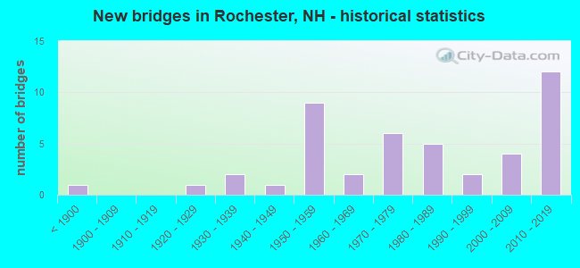
- New bridges - historical statistics
- 1Before 1900
- 11920-1929
- 21930-1939
- 11940-1949
- 91950-1959
- 21960-1969
- 61970-1979
- 51980-1989
- 21990-1999
- 42000-2009
- 122010-2019
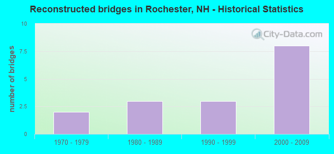
- Reconstructed bridges - Historical Statistics
- 21970-1979
- 31980-1989
- 31990-1999
- 82000-2009
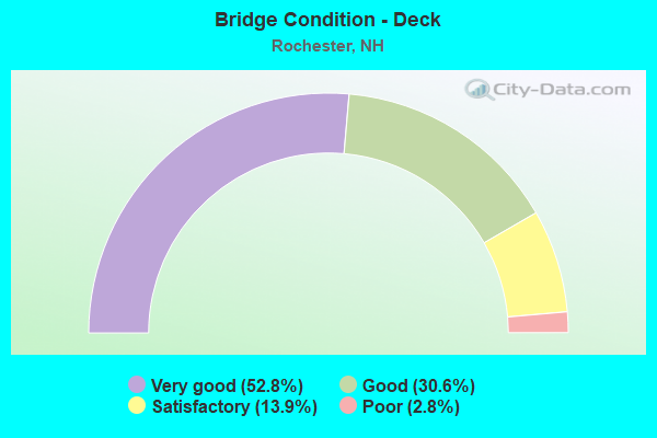
- Bridge Condition - Deck
- 52.8%Very good
- 30.6%Good
- 13.9%Satisfactory
- 2.8%Poor
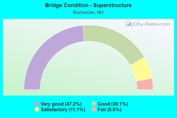
- Bridge Condition - Superstructure
- 47.2%Very good
- 36.1%Good
- 11.1%Satisfactory
- 5.6%Fair
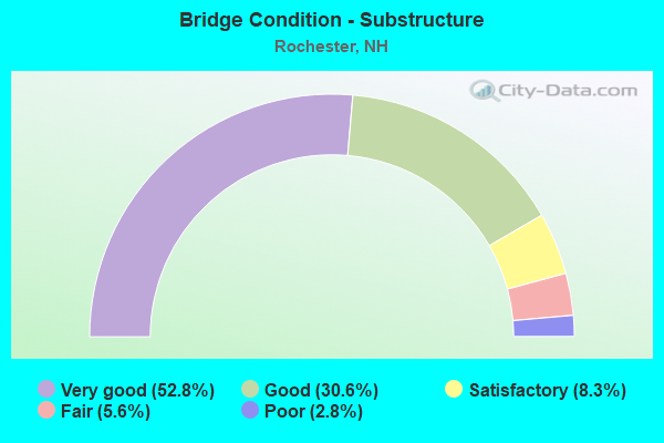
- Bridge Condition - Substructure
- 52.8%Very good
- 30.6%Good
- 8.3%Satisfactory
- 5.6%Fair
- 2.8%Poor
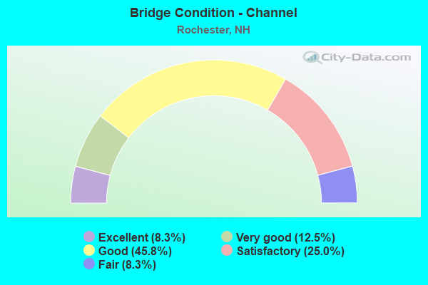
- Bridge Condition - Channel
- 8.3%Excellent
- 12.5%Very good
- 45.8%Good
- 25.0%Satisfactory
- 8.3%Fair
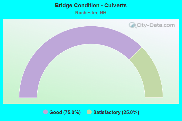
- Bridge Condition - Culverts
- 75.0%Good
- 25.0%Satisfactory
Find on map >> Show street view
Structure Number: 222019600101, Location: 600FT S JCT FLAGG RD (Lat: 43.255758, Lng: -70.989753), Route carried "on" structure: Other road , Year Built: 1988, Status: Open, Structure Length: 2.65m (8.69ft), Average Daily Traffic: 683 (year 2020), Average Future Daily Traffic: 1,010 (year 2042), Design Load: HS 20, Features Intersected: BROOK, Facility Carried by Structure: STILLWATER CIRCLE
Minimum Vertical Clearance: 30+ m (98+ ft), Kilometerpoint: 0.196, Lanes on structure: 2, Owner: City or Municipal Highway Agency, Approaching Roadway Width: 7.5m (24.6ft), Material/Design: Prestressed concrete, Design/Construction: Box Beam or Girders - Multiple, Number Of Spans In Main Unit: 1, Length of Maximum Span: 24.4m (80.1ft), Curb or Sidewalk Widths: Left: 0.0m, Right: 0.1m (0.3ft), Curb-To-Curb Width: 7.3m (24.0ft), Out-to-Out Width: 10.7m (35.1ft)
Condition: Deck: Good, Superstructure: Good, Substructure: Good, Channel: Good, Operating Rating: 46.9 metric tons, Method Used To Determine Operating Rating: Load and Resistance Factor (LRFR), Inventory Rating: 36.2 metric tons, Method Used To Determine Inventory Rating: Load and Resistance Factor (LRFR), Structural Evaluation: Better than present minimum criteria, Deck Geometry: Meets minimum limits, Waterway Adequacy: Meets minimum limits, Approach Roadway Alignment: Equal to present minimum criteria, Length Of Structure Improvement: 2.65m (8.69ft), Designated Inspection Frequency: Every 24 months, Inspection Date: August 2021, Bridge Improvement Cost: $2,718,000, Roadway Improvement Cost: $200,000, Total Project Cost: $3,142,000 ( Estimate for 2022), Deck Structure Type: Concrete Cast-file-Place, Wearing Surface/Protective System: Wearing Surface: Bituminous, Membrane: Preformed Fabric
Find on map >> Show street view
Structure Number: 22202060011, Location: .1 MI BARRINGTON T.L. (Lat: 43.248475, Lng: -70.982056), Route carried "on" structure: State highway 125, Year Built: 1951, Year Reconstructed: 1979, Status: Open, Structure Length: 3.63m (11.91ft), Average Daily Traffic: 12,442 (year 2020), Truck Traffic: 5%, Average Future Daily Traffic: 18,414 (year 2042), Design Load: H 20, Features Intersected: ISINGLASS RIVER
Minimum Vertical Clearance: 30+ m (98+ ft), Kilometerpoint: 53.425, Lanes on structure: 2, Base Highway Network: Yes, Owner: State Highway Agency, Approaching Roadway Width: 12.8m (42.0ft), Material/Design: Steel, Design/Construction: Stringer/Multi-beam, Number Of Spans In Main Unit: 2, Length of Maximum Span: 17.4m (57.1ft), Curb or Sidewalk Widths: Left: 0.2m (0.7ft), Right: 0.2m (0.7ft), Curb-To-Curb Width: 13.0m (42.7ft), Out-to-Out Width: 13.7m (44.9ft)
Condition: Deck: Poor, Superstructure: Satisfactory, Substructure: Fair, Channel: Satisfactory, Operating Rating: 30.8 metric tons, Method Used To Determine Operating Rating: Load Factor (LF), Inventory Rating: 18.4 metric tons, Method Used To Determine Inventory Rating: Load Factor (LF), Structural Evaluation: Meets minimum limits, Deck Geometry: Somewhat better than minimum adequacy, Waterway Adequacy: Superior to present desirable criteria, Approach Roadway Alignment: Equal to present desirable criteria, Length Of Structure Improvement: 3.63m (11.91ft), Designated Inspection Frequency: Every 8 months, Inspection Date: November 2021, Bridge Improvement Cost: $2,718,000, Roadway Improvement Cost: $200,000, Total Project Cost: $3,142,000 ( Estimate for 2022), Deck Structure Type: Concrete Cast-file-Place, Wearing Surface/Protective System: Wearing Surface: Bituminous, Membrane: Other
Find on map >> Show street view
Structure Number: 222022500139, Location: 1.95 MI RTE 125 (Lat: 43.233517, Lng: -70.955453), Route carried "on" structure: Other road , Year Built: 1979, Year Reconstructed: 1999, Status: Open, Structure Length: 2.04m (6.69ft), Average Daily Traffic: 968 (year 2020), Truck Traffic: 4%, Average Future Daily Traffic: 1,432 (year 2042), Features Intersected: ISINGLASS RIVER, Facility Carried by Structure: ROCHESTER NECK RD
Minimum Vertical Clearance: 30+ m (98+ ft), Kilometerpoint: 3.153, Lanes on structure: 2, Owner: City or Municipal Highway Agency, Approaching Roadway Width: 6.7m (22.0ft), Material/Design: Steel, Design/Construction: Stringer/Multi-beam, Number Of Spans In Main Unit: 1, Length of Maximum Span: 16.8m (55.1ft), Curb-To-Curb Width: 7.9m (25.9ft), Out-to-Out Width: 8.6m (28.2ft)
Condition: Deck: Satisfactory, Superstructure: Fair, Substructure: Satisfactory, Channel: Good, Operating Rating: 25.1 metric tons, Method Used To Determine Operating Rating: Load Factor (LF), Inventory Rating: 16.3 metric tons, Method Used To Determine Inventory Rating: Load Factor (LF), Structural Evaluation: Meets minimum limits, Deck Geometry: Somewhat better than minimum adequacy, Waterway Adequacy: Equal to present desirable criteria, Approach Roadway Alignment: Equal to present desirable criteria, Length Of Structure Improvement: 2.04m (6.69ft), Designated Inspection Frequency: Every 24 months, Inspection Date: August 2021, Bridge Improvement Cost: $2,718,000, Roadway Improvement Cost: $200,000, Total Project Cost: $3,142,000 ( Estimate for 2022), Deck Structure Type: Concrete Cast-file-Place, Wearing Surface/Protective System: Wearing Surface: Monolithic Concrete
Find on map >> Show street view
Structure Number: 222008900112, Location: .7 MI FROM JCT NH 16 (Lat: 43.331197, Lng: -70.973156), Route carried "under" structure: Ramp US 202, Year Built: 1966, Structure Length: 0. m, Average Daily Traffic: 5,300 (year 2013), Truck Traffic: 4%, Features Intersected: US202,NH 11 WB(RAMP A), Facility Carried by Structure: NH125(RAMP D)
Minimum Vertical Clearance: 4.67m (15.32ft), Kilometerpoint: 0.000, Lanes on structure: 2, Lanes under structure: 2, Material/Design: Steel continuous, Design/Construction: Stringer/Multi-beam, Length of Maximum Span: 15.5m (50.9ft)
Find on map >> Show street view
Structure Number: 22200930011, Location: NH 16 INTERCHANGE (Lat: 43.330083, Lng: -70.974831), Route carried "under" structure: State highway 16, Year Built: 1957, Structure Length: 0. m, Average Daily Traffic: 9,500 (year 2013), Truck Traffic: 5%, Features Intersected: NH125, Facility Carried by Structure: US202,NH 11
Minimum Vertical Clearance: 4.51m (14.80ft), Kilometerpoint: 0.000, Lanes on structure: 2, Lanes under structure: 4, Material/Design: Steel continuous, Design/Construction: Stringer/Multi-beam, Length of Maximum Span: 17.1m (56.1ft)
Find on map >> Show street view
Structure Number: 22201090009, Location: .8 MI FROM JCT NH202-A (Lat: 43.318700, Lng: -70.995378), Route carried "under" structure: Other road 16, Year Built: 2011, Structure Length: 0. m, Average Daily Traffic: 29,000 (year 2013), Truck Traffic: 7%, Features Intersected: US202,NH 16,SP TPK, Facility Carried by Structure: NH 11
Minimum Vertical Clearance: 4.88m (16.01ft), Kilometerpoint: 0.000, Lanes on structure: 4, Lanes under structure: 2, Material/Design: Steel continuous, Design/Construction: Stringer/Multi-beam, Length of Maximum Span: 30.8m (101.0ft)
Find on map >> Show street view
Structure Number: 22201580011, Location: 3.25 MI N DOVER T/L (Lat: 43.282325, Lng: -70.979339), Route carried "under" structure: State highway 125, Year Built: 2009, Structure Length: 0. m, Average Daily Traffic: 14,000 (year 2013), Truck Traffic: 8%, Features Intersected: NH125, Facility Carried by Structure: NH 16,SP TPK,RAMP
Minimum Vertical Clearance: 4.78m (15.68ft), Kilometerpoint: 0.000, Lanes on structure: 5, Lanes under structure: 6, Material/Design: Steel, Design/Construction: Stringer/Multi-beam, Length of Maximum Span: 43.9m (144.0ft)
Find on map >> Show street view
Structure Number: 222017600133, Location: 1.7 MI FROM DOVER TL (Lat: 43.268597, Lng: -70.957158), Route carried "under" structure: State highway 16, Year Built: 1957, Structure Length: 0. m, Average Daily Traffic: 25,005 (year 2014), Truck Traffic: 8%, Features Intersected: NH 16,SP TPK, Facility Carried by Structure: TEBBETTS ROAD
Minimum Vertical Clearance: 5.00m (16.40ft), Kilometerpoint: 0.000, Lanes on structure: 2, Lanes under structure: 4, Toll: On toll road, Material/Design: Steel continuous, Design/Construction: Stringer/Multi-beam, Length of Maximum Span: 14.3m (46.9ft)