Bridge Statistics for Robstown, Texas (TX)
Condition, Traffic, Stress, Structural Evaluation, Project Costs
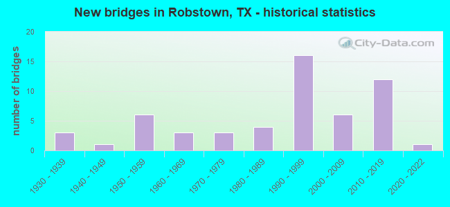
- New bridges - historical statistics
- 31930-1939
- 11940-1949
- 61950-1959
- 31960-1969
- 31970-1979
- 41980-1989
- 161990-1999
- 62000-2009
- 122010-2019
- 12020-2022
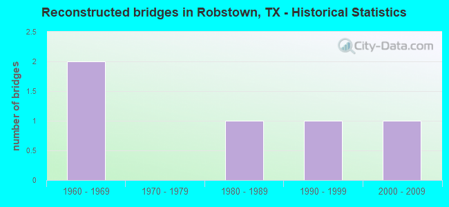
- Reconstructed bridges - Historical Statistics
- 21960-1969
- 01970-1979
- 11980-1989
- 11990-1999
- 12000-2009
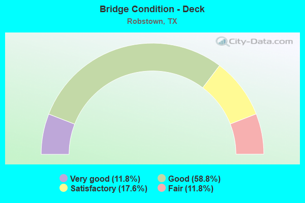
- Bridge Condition - Deck
- 11.8%Very good
- 58.8%Good
- 17.6%Satisfactory
- 11.8%Fair
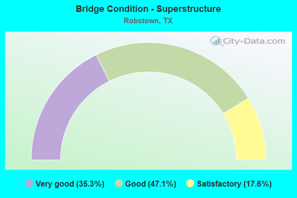
- Bridge Condition - Superstructure
- 35.3%Very good
- 47.1%Good
- 17.6%Satisfactory
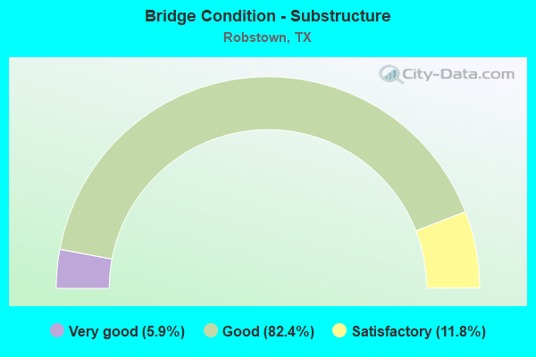
- Bridge Condition - Substructure
- 5.9%Very good
- 82.4%Good
- 11.8%Satisfactory
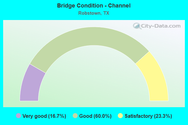
- Bridge Condition - Channel
- 16.7%Very good
- 60.0%Good
- 23.3%Satisfactory
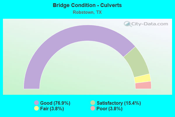
- Bridge Condition - Culverts
- 76.9%Good
- 15.4%Satisfactory
- 3.8%Fair
- 3.8%Poor
Find on map >> Show street view
Structure Number: 161780010201178, Location: 2.3 MI E OF US 77 (Lat: 27.782894, Lng: -97.619914), Route carried "under" structure: State highway 1694, Year Built: 2015, Structure Length: 0. m, Average Daily Traffic: 1,720 (year 2013), Truck Traffic: 24%, Features Intersected: FM 1694, Facility Carried by Structure: SH 44 WB
Minimum Vertical Clearance: 5.05m (16.57ft), Kilometerpoint: 10.329, Lanes on structure: 2, Lanes under structure: 4, Material/Design: Prestressed concrete, Design/Construction: Stringer/Multi-beam, Length of Maximum Span: 29.0m (95.1ft)
Find on map >> Show street view
Structure Number: 161780010201179, Location: 2.3 MI E OF US 77 (Lat: 27.783142, Lng: -97.619031), Route carried "under" structure: State highway 1694, Year Built: 2015, Structure Length: 0. m, Average Daily Traffic: 1,720 (year 2013), Truck Traffic: 24%, Features Intersected: FM 1694, Facility Carried by Structure: SH 44 EB
Minimum Vertical Clearance: 5.05m (16.57ft), Kilometerpoint: 10.329, Lanes on structure: 2, Lanes under structure: 4, Material/Design: Prestressed concrete, Design/Construction: Stringer/Multi-beam, Length of Maximum Span: 29.0m (95.1ft)
Find on map >> Show street view
Structure Number: 161780010202174, Location: 1.1 MI SW OF SH 44 (Lat: 27.775556, Lng: -97.668333), Route carried "under" structure: State highway 892, Year Built: 2011, Structure Length: 0. m, Average Daily Traffic: 10,000 (year 2011), Truck Traffic: 10%, Features Intersected: FM 892, Facility Carried by Structure: US 77
Minimum Vertical Clearance: 5.16m (16.93ft), Kilometerpoint: 0.000, Lanes on structure: 4, Lanes under structure: 2, Material/Design: Prestressed concrete, Design/Construction: Stringer/Multi-beam, Length of Maximum Span: 33.5m (109.9ft)
Find on map >> Show street view
Structure Number: 161780037302014, Location: 0.45 MI NW OF E MAIN AVE (Lat: 27.794644, Lng: -97.656644), Route carried "under" structure: State highway 77, Year Built: 1955, Structure Length: 0. m, Average Daily Traffic: 2,920 (year 2013), Truck Traffic: 8%, Features Intersected: BU 77-UPRR, Facility Carried by Structure: SH 44 WB
Minimum Vertical Clearance: 7.04m (23.10ft), Kilometerpoint: 8.900, Lanes on structure: 2, Lanes under structure: 4, Material/Design: Steel continuous, Design/Construction: Stringer/Multi-beam, Length of Maximum Span: 26.8m (87.9ft)
Find on map >> Show street view
Structure Number: 16178003730203, Location: 0.45 MI NW OF E MAIN AVE (Lat: 27.795194, Lng: -97.657131), Route carried "under" structure: State highway 77, Year Built: 1955, Structure Length: 0. m, Average Daily Traffic: 3,200 (year 2011), Truck Traffic: 10%, Features Intersected: BU 77-UPRR, Facility Carried by Structure: SH 44 EB
Minimum Vertical Clearance: 7.24m (23.75ft), Kilometerpoint: 8.908, Lanes on structure: 2, Lanes under structure: 4, Material/Design: Steel continuous, Design/Construction: Stringer/Multi-beam, Length of Maximum Span: 26.8m (87.9ft)
Find on map >> Show street view
Structure Number: 161780037302096, Location: 2.2 MI W OF FM 1694 (Lat: 27.786933, Lng: -97.654878), Route carried "under" structure: State highway 44, Year Built: 1986, Structure Length: 0. m, Average Daily Traffic: 18,490 (year 2013), Truck Traffic: 13%, Features Intersected: SH 44,TEX-MEX RR & BU 44, Facility Carried by Structure: US 77
Minimum Vertical Clearance: 5.21m (17.09ft), Kilometerpoint: 8.908, Lanes on structure: 4, Lanes under structure: 10, Material/Design: Prestressed concrete, Design/Construction: Stringer/Multi-beam, Length of Maximum Span: 36.6m (120.1ft)
Find on map >> Show street view
Structure Number: 161780037310045, Location: 2.6 MI N OF SH 44 (Lat: 27.816753, Lng: -97.637303), Route carried "under" structure: Business State highway 77, Year Built: 1999, Structure Length: 0. m, Average Daily Traffic: 23,680 (year 2010), Truck Traffic: 5%, Features Intersected: UPRR & BU 77 NB
Minimum Vertical Clearance: 6.99m (22.93ft), Kilometerpoint: 5.504, Lanes on structure: 2, Lanes under structure: 5, Material/Design: Prestressed concrete, Design/Construction: Stringer/Multi-beam, Length of Maximum Span: 33.5m (109.9ft)
Find on map >> Show street view
Structure Number: 161780037310046, Location: 2.6 MI N OF SH 44 (Lat: 27.816789, Lng: -97.637539), Route carried "under" structure: Business State highway 77, Year Built: 1999, Structure Length: 0. m, Average Daily Traffic: 23,680 (year 2010), Truck Traffic: 5%, Features Intersected: UPRR & BU 77 NB
Minimum Vertical Clearance: 7.26m (23.82ft), Kilometerpoint: 5.810, Lanes on structure: 2, Lanes under structure: 4, Material/Design: Prestressed concrete, Design/Construction: Stringer/Multi-beam, Length of Maximum Span: 33.5m (109.9ft)
Find on map >> Show street view
Structure Number: 161780037310049, Location: 2.05 MI N OF SH 44 (Lat: 27.810533, Lng: -97.638508), Route carried "under" structure: County highway 44, Year Built: 1999, Structure Length: 0. m, Average Daily Traffic: 1,500 (year 2010), Truck Traffic: 2%, Features Intersected: CR 44, Facility Carried by Structure: US 77 NB
Minimum Vertical Clearance: 5.41m (17.75ft), Kilometerpoint: 0.161, Lanes on structure: 2, Lanes under structure: 5, Material/Design: Prestressed concrete, Design/Construction: Stringer/Multi-beam, Length of Maximum Span: 30.5m (100.1ft)
Find on map >> Show street view
Structure Number: 16178003731005, Location: 2.05 MI N OF SH 44 (Lat: 27.810544, Lng: -97.638742), Route carried "under" structure: County highway 44, Year Built: 1999, Structure Length: 0. m, Average Daily Traffic: 1,500 (year 2010), Truck Traffic: 2%, Features Intersected: CR 44, Facility Carried by Structure: US 77 SB
Minimum Vertical Clearance: 5.33m (17.49ft), Kilometerpoint: 0.161, Lanes on structure: 2, Lanes under structure: 5, Material/Design: Prestressed concrete, Design/Construction: Stringer/Multi-beam, Length of Maximum Span: 30.5m (100.1ft)
Find on map >> Show street view
Structure Number: 161780037310118, Location: 0.3 MI N OF E MAIN AVE (Lat: 27.792025, Lng: -97.653950), Route carried "under" structure: State highway 44, Year Built: 1999, Structure Length: 0. m, Average Daily Traffic: 1,000 (year 2011), Truck Traffic: 2%, Features Intersected: SH 44 WB, Facility Carried by Structure: US 77 NB
Minimum Vertical Clearance: 5.13m (16.83ft), Kilometerpoint: 0.161, Lanes on structure: 2, Lanes under structure: 6, Material/Design: Prestressed concrete, Design/Construction: Stringer/Multi-beam, Length of Maximum Span: 33.5m (109.9ft)
Find on map >> Show street view
Structure Number: 161780037310119, Location: 0.3 MI N OF E MAIN AVE (Lat: 27.792069, Lng: -97.654081), Route carried "under" structure: State highway 44, Year Built: 1999, Structure Length: 0. m, Average Daily Traffic: 1,000 (year 2011), Truck Traffic: 2%, Features Intersected: SH 44 WB, Facility Carried by Structure: US 77 SB
Minimum Vertical Clearance: 5.11m (16.77ft), Kilometerpoint: 0.161, Lanes on structure: 2, Lanes under structure: 6, Material/Design: Prestressed concrete, Design/Construction: Stringer/Multi-beam, Length of Maximum Span: 33.5m (109.9ft)