Bridge Statistics for Riverside, California (CA)
Condition, Traffic, Stress, Structural Evaluation, Project Costs
- National Bridge Inventory (NBI) Statistics
- 182Number of bridges
- 3,241ft / 988mTotal length
- $24,173,000Total costs
- 13,074,247Total average daily traffic
- 929,308Total average daily truck traffic
- National Bridge Inventory (NBI) Registered Bridges for Riverside
- No street view available for this location
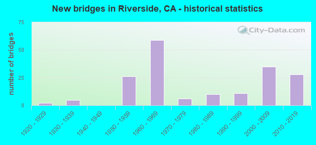
- New bridges - historical statistics
- 21920-1929
- 51930-1939
- 261950-1959
- 591960-1969
- 61970-1979
- 101980-1989
- 111990-1999
- 352000-2009
- 282010-2019

- Reconstructed bridges - Historical Statistics
- 21950-1959
- 41960-1969
- 11970-1979
- 21980-1989
- 111990-1999
- 112000-2009
- 42010-2019
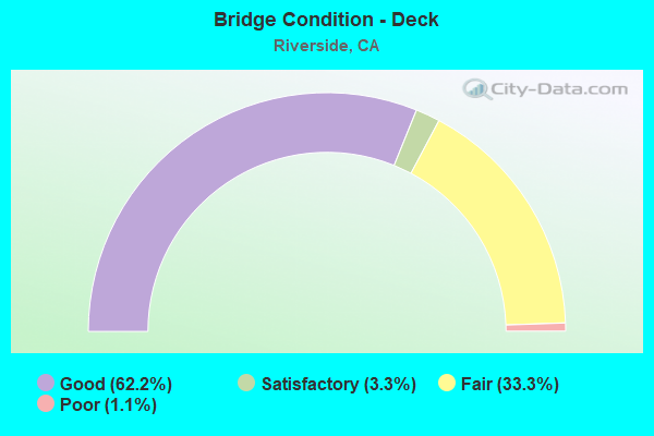
- Bridge Condition - Deck
- 62.2%Good
- 3.3%Satisfactory
- 33.3%Fair
- 1.1%Poor
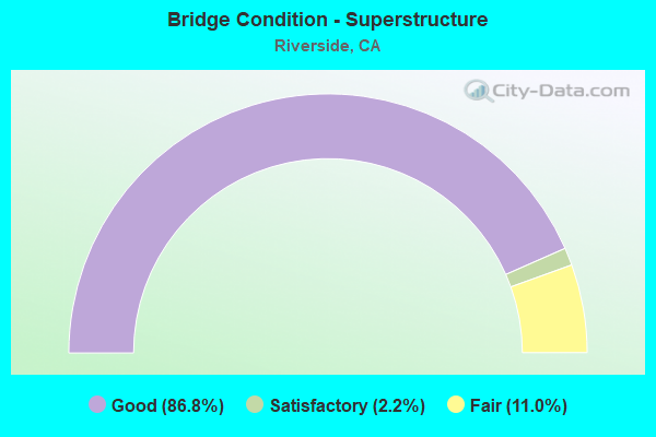
- Bridge Condition - Superstructure
- 86.8%Good
- 2.2%Satisfactory
- 11.0%Fair
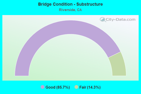
- Bridge Condition - Substructure
- 85.7%Good
- 14.3%Fair
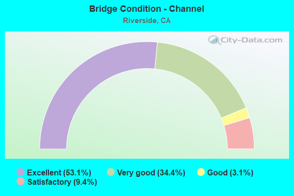
- Bridge Condition - Channel
- 53.1%Excellent
- 34.4%Very good
- 3.1%Good
- 9.4%Satisfactory
Find on map >> Show street view
Structure Number: 56 0082L, Location: 08-RIV-215-R38.61-RIV (Lat: 33.945872, Lng: -117.297389), Route carried "on" structure: Interstate 215, Year Built: 1966, Year Reconstructed: 2013, Status: Open, Structure Length: 5.43m (17.81ft), Average Daily Traffic: 84,000 (year 2009), Truck Traffic: 11%, Average Future Daily Traffic: 176,874 (year 2039), Design Load: HS 20, Features Intersected: BNSF RY & SCRRA
Minimum Vertical Clearance: 30+ m (98+ ft), Kilometerpoint: 38.610, Lanes on structure: 5, Base Highway Network: Yes (Inventory Route: 2, Subroute: 1), Owner: State Highway Agency, Approaching Roadway Width: 29.0m (95.1ft), Skew: 4 degrees, Material/Design: Prestressed concrete, Design/Construction: Tee Beam, Number Of Spans In Main Unit: 1, Number Of Approach Spans: 2, Length of Maximum Span: 18.7m (61.4ft), Curb-To-Curb Width: 29.0m (95.1ft), Out-to-Out Width: 29.7m (97.4ft)
Condition: Deck: Good, Superstructure: Good, Substructure: Good, Operating Rating: 54.1 metric tons, Method Used To Determine Operating Rating: Assigned rating based on Load Factor Design (LFD) reported in metric tons, Inventory Rating: 32.4 metric tons, Method Used To Determine Inventory Rating: Assigned rating based on Load Factor Design (LFD) reported in metric tons, Structural Evaluation: Better than present minimum criteria, Deck Geometry: Superior to present desirable criteria, Underclear: Better than present minimum criteria, Approach Roadway Alignment: Equal to present desirable criteria, Designated Inspection Frequency: Every 48 months, Inspection Date: May 2019, Deck Structure Type: Concrete Cast-file-Place, Wearing Surface/Protective System: Wearing Surface: Bituminous
Find on map >> Show street view
Structure Number: 56 0082R, Location: 08-RIV-215-R38.67-RIV (Lat: 33.946483, Lng: -117.297739), Route carried "on" structure: Interstate 215, Year Built: 1936, Year Reconstructed: 2014, Status: Open, Structure Length: 3.96m (12.99ft), Average Daily Traffic: 84,000 (year 2009), Truck Traffic: 11%, Average Future Daily Traffic: 176,874 (year 2039), Design Load: HS 20+Mod, Features Intersected: BNSF RY & SCRRA
Minimum Vertical Clearance: 30+ m (98+ ft), Kilometerpoint: 38.670, Lanes on structure: 5, Base Highway Network: Yes (Inventory Route: 2, Subroute: 1), Owner: State Highway Agency, Approaching Roadway Width: 38.5m (126.3ft), Skew: 34 degrees, Material/Design: Prestressed concrete continuous, Design/Construction: Slab, Number Of Spans In Main Unit: 3, Length of Maximum Span: 18.2m (59.7ft), Curb-To-Curb Width: 38.5m (126.3ft), Out-to-Out Width: 40.0m (131.2ft)
Condition: Deck: Good, Superstructure: Good, Substructure: Good, Operating Rating: 54.1 metric tons, Method Used To Determine Operating Rating: Assigned rating based on Load Factor Design (LFD) reported in metric tons, Inventory Rating: 32.4 metric tons, Method Used To Determine Inventory Rating: Assigned rating based on Load Factor Design (LFD) reported in metric tons, Structural Evaluation: Better than present minimum criteria, Deck Geometry: Superior to present desirable criteria, Underclear: Somewhat better than minimum adequacy, Approach Roadway Alignment: Equal to present desirable criteria, Designated Inspection Frequency: Every 48 months, Inspection Date: May 2019, Deck Structure Type: Concrete Cast-file-Place
Find on map >> Show street view
Structure Number: 56 0085, Location: 08-RIV-215-41.04-RIV (Lat: 33.970817, Lng: -117.329958), Route carried "on" structure: Interstate 215, Year Built: 1959, Year Reconstructed: 2008, Status: Open, Structure Length: 3.35m (10.99ft), Average Daily Traffic: 168,000 (year 2012), Truck Traffic: 11%, Average Future Daily Traffic: 353,748 (year 2039), Design Load: HS 20, Features Intersected: CANYON CREST DR
Minimum Vertical Clearance: 30+ m (98+ ft), Kilometerpoint: 41.040, Lanes on structure: 12, Lanes under structure: 4, Base Highway Network: Yes (Inventory Route: 2, Subroute: 1), Owner: State Highway Agency, Approaching Roadway Width: 63.8m (209.3ft), Skew: 30 degrees, Material/Design: Concrete continuous, Design/Construction: Tee Beam, Number Of Spans In Main Unit: 3, Length of Maximum Span: 14.0m (45.9ft), Curb-To-Curb Width: 63.8m (209.3ft), Out-to-Out Width: 65.3m (214.2ft)
Condition: Deck: Fair, Superstructure: Good, Substructure: Good, Operating Rating: 54.1 metric tons, Method Used To Determine Operating Rating: Assigned rating based on Load Factor Design (LFD) reported in metric tons, Inventory Rating: 32.4 metric tons, Method Used To Determine Inventory Rating: Assigned rating based on Load Factor Design (LFD) reported in metric tons, Structural Evaluation: Better than present minimum criteria, Deck Geometry: Superior to present desirable criteria, Underclear: High priority of corrective action, Approach Roadway Alignment: Equal to present desirable criteria, Designated Inspection Frequency: Every 24 months, Inspection Date: April 2021, Deck Structure Type: Concrete Cast-file-Place, Wearing Surface/Protective System: Wearing Surface: Bituminous
Find on map >> Show street view
Structure Number: 56 0314, Location: 08-RIV-091-20.45-RIV (Lat: 33.979678, Lng: -117.370075), Route carried "on" structure: State highway 91, Year Built: 1957, Year Reconstructed: 2003, Status: Open, Structure Length: 3.29m (10.79ft), Average Daily Traffic: 191,000 (year 2019), Truck Traffic: 5%, Average Future Daily Traffic: 245,500 (year 2041), Design Load: HS 20+Mod, Features Intersected: UNIVERSITY AVENUE
Minimum Vertical Clearance: 30+ m (98+ ft), Kilometerpoint: 20.450, Lanes on structure: 11, Lanes under structure: 5, Base Highway Network: Yes (, Subroute: 1), Owner: State Highway Agency, Approaching Roadway Width: 23.5m (77.1ft), Skew: 31 degrees, Material/Design: Steel, Design/Construction: Stringer/Multi-beam, Number Of Spans In Main Unit: 1, Length of Maximum Span: 31.7m (104.0ft), Curb-To-Curb Width: 46.0m (150.9ft), Out-to-Out Width: 47.5m (155.8ft)
Condition: Deck: Fair, Superstructure: Good, Substructure: Good, Operating Rating: 39.5 metric tons, Method Used To Determine Operating Rating: Load and Resistance Factor Rating (LRFR) rating reported by rating factor(RF) method using HL-93 loadings, Inventory Rating: 17.2 metric tons, Method Used To Determine Inventory Rating: Load and Resistance Factor Rating (LRFR) rating reported by rating factor(RF) method using HL-93 loadings, Structural Evaluation: Meets minimum limits, Deck Geometry: Equal to present minimum criteria, Underclear: Somewhat better than minimum adequacy, Approach Roadway Alignment: Equal to present desirable criteria, Designated Inspection Frequency: Every 24 months, Critical Feature Inspection Frequency: Every 24 months, Other Special Inspection Frequency: Every 48 months, Inspection Date: October 2021, Critical Feature Inspection Date: December 2021, Other Special Inspection Date: December 2021, Deck Structure Type: Concrete Cast-file-Place
Find on map >> Show street view
Structure Number: 56 0315, Location: 08-RIV-091-20.53-RIV (Lat: 33.980572, Lng: -117.369047), Route carried "on" structure: State highway 91, Year Built: 1957, Year Reconstructed: 2003, Status: Open, Structure Length: 3.36m (11.02ft), Average Daily Traffic: 191,000 (year 2019), Truck Traffic: 5%, Average Future Daily Traffic: 241,523 (year 2041), Design Load: HS 20+Mod, Features Intersected: MISSION INN AVE
Minimum Vertical Clearance: 30+ m (98+ ft), Kilometerpoint: 20.530, Lanes on structure: 11, Lanes under structure: 5, Base Highway Network: Yes (, Subroute: 1), Owner: State Highway Agency, Approaching Roadway Width: 22.6m (74.1ft), Skew: 31 degrees, Material/Design: Steel, Design/Construction: Stringer/Multi-beam, Number Of Spans In Main Unit: 1, Length of Maximum Span: 32.3m (106.0ft), Curb-To-Curb Width: 45.3m (148.6ft), Out-to-Out Width: 46.7m (153.2ft)
Condition: Deck: Fair, Superstructure: Good, Substructure: Good, Operating Rating: 51.5 metric tons, Method Used To Determine Operating Rating: Load and Resistance Factor Rating (LRFR) rating reported by rating factor(RF) method using HL-93 loadings, Inventory Rating: 26.2 metric tons, Method Used To Determine Inventory Rating: Load and Resistance Factor Rating (LRFR) rating reported by rating factor(RF) method using HL-93 loadings, Structural Evaluation: Equal to present minimum criteria, Deck Geometry: Somewhat better than minimum adequacy, Underclear: Equal to present minimum criteria, Approach Roadway Alignment: Superior to present desirable criteria, Designated Inspection Frequency: Every 24 months, Critical Feature Inspection Frequency: Every 24 months, Other Special Inspection Frequency: Every 48 months, Inspection Date: October 2021, Critical Feature Inspection Date: December 2021, Other Special Inspection Date: December 2021, Deck Structure Type: Concrete Cast-file-Place
Find on map >> Show street view
Structure Number: 56 0316, Location: 08-RIV-091-20.85-RIV (Lat: 33.984019, Lng: -117.365617), Route carried "on" structure: State highway 91, Year Built: 1957, Year Reconstructed: 2003, Status: Open, Structure Length: 2.41m (7.91ft), Average Daily Traffic: 191,000 (year 2019), Truck Traffic: 5%, Average Future Daily Traffic: 245,500 (year 2040), Design Load: HS 20, Features Intersected: THIRD STREET
Minimum Vertical Clearance: 30+ m (98+ ft), Kilometerpoint: 20.850, Lanes on structure: 13, Lanes under structure: 4, Base Highway Network: Yes (, Subroute: 1), Owner: State Highway Agency, Approaching Roadway Width: 30.0m (98.4ft), Skew: 30 degrees, Material/Design: Steel, Design/Construction: Stringer/Multi-beam, Number Of Spans In Main Unit: 1, Length of Maximum Span: 23.2m (76.1ft), Curb-To-Curb Width: 56.6m (185.7ft), Out-to-Out Width: 58.1m (190.6ft)
Condition: Deck: Fair, Superstructure: Good, Substructure: Good, Operating Rating: 37.6 metric tons, Method Used To Determine Operating Rating: Load and Resistance Factor Rating (LRFR) rating reported by rating factor(RF) method using HL-93 loadings, Inventory Rating: 21.4 metric tons, Method Used To Determine Inventory Rating: Load and Resistance Factor Rating (LRFR) rating reported by rating factor(RF) method using HL-93 loadings, Structural Evaluation: Somewhat better than minimum adequacy, Deck Geometry: Superior to present desirable criteria, Underclear: Meets minimum limits, Approach Roadway Alignment: Superior to present desirable criteria, Designated Inspection Frequency: Every 24 months, Inspection Date: October 2021, Deck Structure Type: Concrete Cast-file-Place
Find on map >> Show street view
Structure Number: 56 033, Location: 08-RIV-091-17.82-RIV (Lat: 33.946178, Lng: -117.388683), Route carried "on" structure: State highway 91, Year Built: 1957, Year Reconstructed: 2003, Status: Open, Structure Length: 4.32m (14.17ft), Average Daily Traffic: 192,000 (year 2019), Truck Traffic: 5%, Average Future Daily Traffic: 241,523 (year 2040), Design Load: HS 20+Mod, Features Intersected: ARLINGTON AVENUE
Minimum Vertical Clearance: 30+ m (98+ ft), Kilometerpoint: 17.820, Lanes on structure: 9, Lanes under structure: 7, Base Highway Network: Yes (, Subroute: 1), Owner: State Highway Agency, Approaching Roadway Width: 28.4m (93.2ft), Skew: 35 degrees, Material/Design: Steel, Design/Construction: Stringer/Multi-beam, Number Of Spans In Main Unit: 1, Length of Maximum Span: 42.0m (137.8ft), Curb-To-Curb Width: 50.9m (167.0ft), Out-to-Out Width: 52.4m (171.9ft)
Condition: Deck: Good, Superstructure: Good, Substructure: Good, Operating Rating: 39.5 metric tons, Method Used To Determine Operating Rating: Load and Resistance Factor Rating (LRFR) rating reported by rating factor(RF) method using HL-93 loadings, Inventory Rating: 30.5 metric tons, Method Used To Determine Inventory Rating: Load and Resistance Factor Rating (LRFR) rating reported by rating factor(RF) method using HL-93 loadings, Structural Evaluation: Better than present minimum criteria, Deck Geometry: Superior to present desirable criteria, Underclear: Meets minimum limits, Approach Roadway Alignment: Equal to present desirable criteria, Designated Inspection Frequency: Every 24 months, Inspection Date: April 2021, Deck Structure Type: Concrete Cast-file-Place, Wearing Surface/Protective System: Wearing Surface: Integral Concrete
Find on map >> Show street view
Structure Number: 56 0356, Location: 08-RIV-091-18.41-RIV (Lat: 33.953483, Lng: -117.383664), Route carried "on" structure: State highway 91, Year Built: 1957, Year Reconstructed: 2003, Status: Open, Structure Length: 3.56m (11.68ft), Average Daily Traffic: 192,000 (year 2019), Truck Traffic: 5%, Average Future Daily Traffic: 240,721 (year 2040), Design Load: HS 20+Mod, Features Intersected: CENTRAL AVENUE
Minimum Vertical Clearance: 30+ m (98+ ft), Kilometerpoint: 18.410, Lanes on structure: 8, Lanes under structure: 7, Base Highway Network: Yes (, Subroute: 1), Owner: State Highway Agency, Approaching Roadway Width: 25.4m (83.3ft), Skew: 33 degrees, Material/Design: Steel, Design/Construction: Stringer/Multi-beam, Number Of Spans In Main Unit: 1, Length of Maximum Span: 34.4m (112.9ft), Curb or Sidewalk Widths: Left: 0.6m (2.0ft), Right: 0.6m (2.0ft), Curb-To-Curb Width: 48.5m (159.1ft), Out-to-Out Width: 50.0m (164.0ft)
Condition: Deck: Fair, Superstructure: Good, Substructure: Good, Operating Rating: 45.0 metric tons, Method Used To Determine Operating Rating: Load and Resistance Factor Rating (LRFR) rating reported by rating factor(RF) method using HL-93 loadings, Inventory Rating: 34.7 metric tons, Method Used To Determine Inventory Rating: Load and Resistance Factor Rating (LRFR) rating reported by rating factor(RF) method using HL-93 loadings, Structural Evaluation: Better than present minimum criteria, Deck Geometry: Superior to present desirable criteria, Underclear: Meets minimum limits, Approach Roadway Alignment: Equal to present desirable criteria, Designated Inspection Frequency: Every 24 months, Inspection Date: April 2021, Deck Structure Type: Concrete Cast-file-Place
Find on map >> Show street view
Structure Number: 56 0362, Location: 08-RIV-091-5.38-COR (Lat: 33.882256, Lng: -117.582572), Route carried "on" structure: City street R104, Year Built: 1992, Year Reconstructed: 2017, Status: Open, Structure Length: 9.45m (31.00ft), Average Daily Traffic: 30,100 (year 2012), Truck Traffic: 4%, Average Future Daily Traffic: 35,831 (year 2043), Design Load: HS 20+Mod, Features Intersected: STATE ROUTE 91, Facility Carried by Structure: LINCOLN AVENUE
Minimum Vertical Clearance: 30+ m (98+ ft), Kilometerpoint: 0.000, Lanes on structure: 7, Lanes under structure: 16, Owner: State Highway Agency, Approaching Roadway Width: 29.3m (96.1ft), Material/Design: Prestressed concrete continuous, Design/Construction: Box Beam or Girders - Multiple, Number Of Spans In Main Unit: 2, Length of Maximum Span: 50.6m (166.0ft), Curb or Sidewalk Widths: Left: 1.5m (4.9ft), Right: 1.5m (4.9ft), Curb-To-Curb Width: 29.3m (96.1ft), Out-to-Out Width: 32.6m (107.0ft)
Condition: Deck: Good, Superstructure: Good, Substructure: Good, Operating Rating: 68.7 metric tons, Method Used To Determine Operating Rating: Load and Resistance Factor Rating (LRFR) rating reported by rating factor(RF) method using HL-93 loadings, Inventory Rating: 39.2 metric tons, Method Used To Determine Inventory Rating: Load and Resistance Factor Rating (LRFR) rating reported by rating factor(RF) method using HL-93 loadings, Structural Evaluation: Better than present minimum criteria, Deck Geometry: Somewhat better than minimum adequacy, Underclear: Meets minimum limits, Approach Roadway Alignment: Superior to present desirable criteria, Designated Inspection Frequency: Every 24 months, Inspection Date: Febuary 2021, Deck Structure Type: Concrete Cast-file-Place
Find on map >> Show street view
Structure Number: 56 0369, Location: 08-RIV-091-10.81-RIV (Lat: 33.897122, Lng: -117.492922), Route carried "on" structure: State highway 91, Year Built: 1961, Year Reconstructed: 1973, Status: Open, Structure Length: 2.77m (9.09ft), Average Daily Traffic: 219,000 (year 2019), Truck Traffic: 10%, Average Future Daily Traffic: 276,329 (year 2040), Design Load: HS 20, Features Intersected: PIERCE STREET
Minimum Vertical Clearance: 30+ m (98+ ft), Kilometerpoint: 10.810, Lanes on structure: 8, Lanes under structure: 5, Base Highway Network: Yes (, Subroute: 1), Owner: State Highway Agency, Approaching Roadway Width: 20.4m (66.9ft), Skew: 32 degrees, Material/Design: Concrete, Design/Construction: Box Beam or Girders - Multiple, Number Of Spans In Main Unit: 1, Length of Maximum Span: 25.9m (85.0ft), Curb-To-Curb Width: 40.0m (131.2ft), Out-to-Out Width: 41.4m (135.8ft)
Condition: Deck: Fair, Superstructure: Good, Substructure: Good, Operating Rating: 75.8 metric tons, Method Used To Determine Operating Rating: Load Factor (LF), Inventory Rating: 32.4 metric tons, Method Used To Determine Inventory Rating: Load Factor (LF), Structural Evaluation: Better than present minimum criteria, Deck Geometry: Superior to present desirable criteria, Underclear: Meets minimum limits, Approach Roadway Alignment: Equal to present desirable criteria, Designated Inspection Frequency: Every 24 months, Inspection Date: May 2021, Deck Structure Type: Concrete Cast-file-Place
Find on map >> Show street view
Structure Number: 56 0382L, Location: 08-RIV-015-20.95 (Lat: 33.677139, Lng: -117.323542), Route carried "on" structure: Interstate 15, Year Built: 1982, Status: Open, Structure Length: 4.44m (14.57ft), Average Daily Traffic: 61,000 (year 2015), Truck Traffic: 11%, Average Future Daily Traffic: 93,700 (year 2040), Design Load: HS 20+Mod, Features Intersected: MAIN STREET
Minimum Vertical Clearance: 30+ m (98+ ft), Kilometerpoint: 20.950, Lanes on structure: 3, Lanes under structure: 2, Base Highway Network: Yes (, Subroute: 1), Owner: State Highway Agency, Approaching Roadway Width: 19.8m (65.0ft), Material/Design: Prestressed concrete, Design/Construction: Box Beam or Girders - Multiple, Number Of Spans In Main Unit: 1, Length of Maximum Span: 44.4m (145.7ft), Curb-To-Curb Width: 19.8m (65.0ft), Out-to-Out Width: 21.0m (68.9ft)
Condition: Deck: Good, Superstructure: Good, Substructure: Good, Operating Rating: 54.1 metric tons, Method Used To Determine Operating Rating: Assigned rating based on Load Factor Design (LFD) reported in metric tons, Inventory Rating: 32.4 metric tons, Method Used To Determine Inventory Rating: Assigned rating based on Load Factor Design (LFD) reported in metric tons, Structural Evaluation: Better than present minimum criteria, Deck Geometry: Superior to present desirable criteria, Underclear: Meets minimum limits, Approach Roadway Alignment: Equal to present desirable criteria, Designated Inspection Frequency: Every 24 months, Inspection Date: January 2022, Deck Structure Type: Concrete Cast-file-Place
Find on map >> Show street view
Structure Number: 56 0384, Location: 08-RIV-091-16.65-RIV (Lat: 33.935667, Lng: -117.404917), Route carried "on" structure: State highway 91, Year Built: 1959, Year Reconstructed: 2015, Status: Open, Structure Length: 2.61m (8.56ft), Average Daily Traffic: 192,000 (year 2019), Truck Traffic: 5%, Average Future Daily Traffic: 235,195 (year 2040), Design Load: HS 20, Features Intersected: MADISON STREET
Minimum Vertical Clearance: 30+ m (98+ ft), Kilometerpoint: 16.650, Lanes on structure: 8, Lanes under structure: 6, Base Highway Network: Yes (, Subroute: 1), Owner: State Highway Agency, Approaching Roadway Width: 22.4m (73.5ft), Skew: 30 degrees, Material/Design: Steel, Design/Construction: Stringer/Multi-beam, Number Of Spans In Main Unit: 1, Length of Maximum Span: 24.9m (81.7ft), Curb-To-Curb Width: 41.6m (136.5ft), Out-to-Out Width: 42.9m (140.7ft)
Condition: Deck: Fair, Superstructure: Good, Substructure: Good, Operating Rating: 71.3 metric tons, Method Used To Determine Operating Rating: Load Factor (LF), Inventory Rating: 41.1 metric tons, Method Used To Determine Inventory Rating: Load Factor (LF), Structural Evaluation: Better than present minimum criteria, Deck Geometry: Superior to present desirable criteria, Underclear: Somewhat better than minimum adequacy, Approach Roadway Alignment: Superior to present desirable criteria, Designated Inspection Frequency: Every 24 months, Inspection Date: April 2021, Deck Structure Type: Concrete Cast-file-Place
Find on map >> Show street view
Structure Number: 56 0385, Location: 08-RIV-091-17.43-RIV (Lat: 33.942272, Lng: -117.394028), Route carried "on" structure: State highway 91, Year Built: 1959, Year Reconstructed: 2015, Status: Open, Structure Length: 2.62m (8.60ft), Average Daily Traffic: 168,000 (year 2010), Truck Traffic: 5%, Average Future Daily Traffic: 235,195 (year 2036), Design Load: HS 20, Features Intersected: BROCKTON AVENUE
Minimum Vertical Clearance: 30+ m (98+ ft), Kilometerpoint: 17.430, Lanes on structure: 10, Lanes under structure: 4, Base Highway Network: Yes (, Subroute: 1), Owner: State Highway Agency, Approaching Roadway Width: 24.2m (79.4ft), Skew: 30 degrees, Material/Design: Steel, Design/Construction: Stringer/Multi-beam, Number Of Spans In Main Unit: 1, Length of Maximum Span: 25.0m (82.0ft), Curb-To-Curb Width: 46.1m (151.2ft), Out-to-Out Width: 47.6m (156.2ft)
Condition: Deck: Good, Superstructure: Good, Substructure: Good, Operating Rating: 73.5 metric tons, Method Used To Determine Operating Rating: Load Factor (LF), Inventory Rating: 33.4 metric tons, Method Used To Determine Inventory Rating: Load Factor (LF), Structural Evaluation: Better than present minimum criteria, Deck Geometry: Superior to present desirable criteria, Underclear: Somewhat better than minimum adequacy, Approach Roadway Alignment: Superior to present desirable criteria, Designated Inspection Frequency: Every 48 months, Inspection Date: October 2019, Deck Structure Type: Concrete Cast-file-Place
Find on map >> Show street view
Structure Number: 56 0387, Location: 08-RIV-091-16.14-RIV (Lat: 33.931483, Lng: -117.412353), Route carried "on" structure: State highway 91, Year Built: 1959, Year Reconstructed: 2015, Status: Open, Structure Length: 2.60m (8.53ft), Average Daily Traffic: 199,000 (year 2019), Truck Traffic: 5%, Average Future Daily Traffic: 235,195 (year 2040), Design Load: HS 20, Features Intersected: JEFFERSON STREET
Minimum Vertical Clearance: 30+ m (98+ ft), Kilometerpoint: 16.140, Lanes on structure: 9, Lanes under structure: 2, Base Highway Network: Yes (, Subroute: 1), Owner: State Highway Agency, Approaching Roadway Width: 23.5m (77.1ft), Skew: 30 degrees, Material/Design: Steel, Design/Construction: Stringer/Multi-beam, Number Of Spans In Main Unit: 1, Length of Maximum Span: 24.4m (80.1ft), Curb-To-Curb Width: 42.2m (138.5ft), Out-to-Out Width: 43.8m (143.7ft)
Condition: Deck: Fair, Superstructure: Good, Substructure: Good, Operating Rating: 71.3 metric tons, Method Used To Determine Operating Rating: Load Factor (LF), Inventory Rating: 41.1 metric tons, Method Used To Determine Inventory Rating: Load Factor (LF), Structural Evaluation: Better than present minimum criteria, Deck Geometry: Superior to present desirable criteria, Underclear: Equal to present minimum criteria, Approach Roadway Alignment: Superior to present desirable criteria, Designated Inspection Frequency: Every 24 months, Inspection Date: May 2021, Deck Structure Type: Concrete Cast-file-Place
Find on map >> Show street view
Structure Number: 56 0388, Location: 08-RIV-091-15.63-RIV (Lat: 33.927500, Lng: -117.419956), Route carried "on" structure: City street R143, Year Built: 1959, Year Reconstructed: 1965, Status: Open, Structure Length: 3.57m (11.71ft), Average Daily Traffic: 20,000 (year 2020), Truck Traffic: 1%, Average Future Daily Traffic: 22,000 (year 2040), Design Load: HS 20, Features Intersected: ROUTE 91, Facility Carried by Structure: ADAMS STREET
Minimum Vertical Clearance: 30+ m (98+ ft), Kilometerpoint: 0.000, Lanes on structure: 6, Lanes under structure: 8, Owner: State Highway Agency, Approaching Roadway Width: 20.4m (66.9ft), Material/Design: Concrete continuous, Design/Construction: Box Beam or Girders - Multiple, Number Of Spans In Main Unit: 2, Number Of Approach Spans: 2, Length of Maximum Span: 17.5m (57.4ft), Curb or Sidewalk Widths: Left: 1.5m (4.9ft), Right: 1.5m (4.9ft), Curb-To-Curb Width: 20.4m (66.9ft), Out-to-Out Width: 24.1m (79.1ft)
Condition: Deck: Good, Superstructure: Good, Substructure: Good, Operating Rating: 28.5 metric tons, Method Used To Determine Operating Rating: Load and Resistance Factor Rating (LRFR) rating reported by rating factor(RF) method using HL-93 loadings, Inventory Rating: 22.0 metric tons, Method Used To Determine Inventory Rating: Load and Resistance Factor Rating (LRFR) rating reported by rating factor(RF) method using HL-93 loadings, Structural Evaluation: Somewhat better than minimum adequacy, Deck Geometry: High priority of replacement, Underclear: High priority of corrective action, Approach Roadway Alignment: Superior to present desirable criteria, Designated Inspection Frequency: Every 24 months, Inspection Date: May 2021, Deck Structure Type: Concrete Cast-file-Place, Wearing Surface/Protective System: Wearing Surface: Bituminous
Find on map >> Show street view
Structure Number: 56 039, Location: 08-RIV-091-14.60-RIV (Lat: 33.919186, Lng: -117.434833), Route carried "on" structure: City street , Year Built: 2003, Status: Open, Structure Length: 6.20m (20.34ft), Average Daily Traffic: 11,200 (year 2020), Truck Traffic: 2%, Average Future Daily Traffic: 13,500 (year 2040), Design Load: HS 20, Features Intersected: STATE ROUTE 91, Facility Carried by Structure: JACKSON STREET
Minimum Vertical Clearance: 30+ m (98+ ft), Kilometerpoint: 0.000, Lanes on structure: 2, Lanes under structure: 10, Owner: State Highway Agency, Approaching Roadway Width: 12.5m (41.0ft), Material/Design: Prestressed concrete continuous, Design/Construction: Box Beam or Girders - Multiple, Number Of Spans In Main Unit: 2, Length of Maximum Span: 31.0m (101.7ft), Curb or Sidewalk Widths: Left: 1.8m (5.9ft), Right: 1.8m (5.9ft), Curb-To-Curb Width: 12.5m (41.0ft), Out-to-Out Width: 15.6m (51.2ft)
Condition: Deck: Good, Superstructure: Good, Substructure: Good, Operating Rating: 54.1 metric tons, Method Used To Determine Operating Rating: Assigned rating based on Load Factor Design (LFD) reported in metric tons, Inventory Rating: 32.4 metric tons, Method Used To Determine Inventory Rating: Assigned rating based on Load Factor Design (LFD) reported in metric tons, Structural Evaluation: Better than present minimum criteria, Deck Geometry: Somewhat better than minimum adequacy, Underclear: High priority of corrective action, Approach Roadway Alignment: Somewhat better than minimum adequacy, Designated Inspection Frequency: Every 24 months, Inspection Date: May 2021, Deck Structure Type: Concrete Cast-file-Place
Find on map >> Show street view
Structure Number: 56 0391, Location: 08-RIV-091-15.10-RIV (Lat: 33.922969, Lng: -117.427147), Route carried "on" structure: State highway 91, Year Built: 1959, Year Reconstructed: 2004, Status: Open, Structure Length: 2.56m (8.40ft), Average Daily Traffic: 203,000 (year 2019), Truck Traffic: 5%, Average Future Daily Traffic: 242,578 (year 2040), Design Load: HS 20, Features Intersected: MONROE STREET
Minimum Vertical Clearance: 30+ m (98+ ft), Kilometerpoint: 15.100, Lanes on structure: 10, Lanes under structure: 2, Base Highway Network: Yes (, Subroute: 1), Owner: State Highway Agency, Approaching Roadway Width: 22.5m (73.8ft), Skew: 30 degrees, Material/Design: Concrete, Design/Construction: Stringer/Multi-beam, Number Of Spans In Main Unit: 1, Length of Maximum Span: 24.4m (80.1ft), Curb-To-Curb Width: 47.1m (154.5ft), Out-to-Out Width: 47.1m (154.5ft)
Condition: Deck: Fair, Superstructure: Good, Substructure: Good, Operating Rating: 71.3 metric tons, Method Used To Determine Operating Rating: Load Factor (LF), Inventory Rating: 41.1 metric tons, Method Used To Determine Inventory Rating: Load Factor (LF), Structural Evaluation: Better than present minimum criteria, Deck Geometry: Superior to present desirable criteria, Underclear: Equal to present minimum criteria, Approach Roadway Alignment: Superior to present desirable criteria, Designated Inspection Frequency: Every 24 months, Inspection Date: May 2021, Deck Structure Type: Concrete Cast-file-Place
Find on map >> Show street view
Structure Number: 56 0394, Location: 08-RIV-091-14.08-RIV (Lat: 33.914911, Lng: -117.442272), Route carried "on" structure: City street R093, Year Built: 2011, Status: Open, Structure Length: 6.14m (20.14ft), Average Daily Traffic: 24,000 (year 2020), Truck Traffic: 2%, Average Future Daily Traffic: 27,313 (year 2040), Design Load: HS 20, Features Intersected: STATE ROUTE 91, Facility Carried by Structure: VAN BUREN BLVD
Minimum Vertical Clearance: 30+ m (98+ ft), Kilometerpoint: 0.000, Lanes on structure: 10, Lanes under structure: 9, Base Highway Network: Yes, Owner: State Highway Agency, Approaching Roadway Width: 19.9m (65.3ft), Skew: 30 degrees, Material/Design: Concrete continuous, Design/Construction: Box Beam or Girders - Multiple, Number Of Spans In Main Unit: 2, Length of Maximum Span: 34.7m (113.8ft), Curb or Sidewalk Widths: Left: 1.5m (4.9ft), Right: 1.5m (4.9ft), Curb-To-Curb Width: 41.4m (135.8ft), Out-to-Out Width: 46.1m (151.2ft)
Condition: Deck: Fair, Superstructure: Good, Substructure: Good, Operating Rating: 37.9 metric tons, Method Used To Determine Operating Rating: Load and Resistance Factor Rating (LRFR) rating reported by rating factor(RF) method using HL-93 loadings, Inventory Rating: 29.5 metric tons, Method Used To Determine Inventory Rating: Load and Resistance Factor Rating (LRFR) rating reported by rating factor(RF) method using HL-93 loadings, Structural Evaluation: Better than present minimum criteria, Deck Geometry: Equal to present minimum criteria, Underclear: High priority of corrective action, Approach Roadway Alignment: Superior to present desirable criteria, Designated Inspection Frequency: Every 24 months, Inspection Date: May 2021, Deck Structure Type: Concrete Cast-file-Place
Find on map >> Show street view
Structure Number: 56 0398, Location: 08-RIV-215-R43.08R-RIV (Lat: 33.992247, Lng: -117.354047), Route carried "on" structure: Interstate 215, Year Built: 1961, Year Reconstructed: 2008, Status: Open, Structure Length: 4.16m (13.65ft), Average Daily Traffic: 200,000 (year 2012), Truck Traffic: 7%, Average Future Daily Traffic: 225,658 (year 2039), Design Load: HS 20, Features Intersected: DOWN ST,AMTRAK,METROLINK
Minimum Vertical Clearance: 30+ m (98+ ft), Kilometerpoint: 43.080, Lanes on structure: 12, Lanes under structure: 2, Base Highway Network: Yes (Inventory Route: 2, Subroute: 1), Owner: State Highway Agency, Approaching Roadway Width: 78.3m (256.9ft), Skew: 31 degrees, Material/Design: Prestressed concrete, Design/Construction: Stringer/Multi-beam, Number Of Spans In Main Unit: 2, Length of Maximum Span: 24.0m (78.7ft), Curb-To-Curb Width: 78.3m (256.9ft), Out-to-Out Width: 80.4m (263.8ft)
Condition: Deck: Good, Superstructure: Good, Substructure: Good, Operating Rating: 37.3 metric tons, Method Used To Determine Operating Rating: Load and Resistance Factor Rating (LRFR) rating reported by rating factor(RF) method using HL-93 loadings, Inventory Rating: 19.4 metric tons, Method Used To Determine Inventory Rating: Load and Resistance Factor Rating (LRFR) rating reported by rating factor(RF) method using HL-93 loadings, Structural Evaluation: Meets minimum limits, Deck Geometry: Superior to present desirable criteria, Underclear: Somewhat better than minimum adequacy, Approach Roadway Alignment: Equal to present desirable criteria, Designated Inspection Frequency: Every 24 months, Inspection Date: April 2021, Deck Structure Type: Concrete Cast-file-Place
Find on map >> Show street view
Structure Number: 56 0399, Location: 08-RIV-215-R42.84R-RIV (Lat: 33.990286, Lng: -117.350939), Route carried "on" structure: Interstate 215, Year Built: 1961, Year Reconstructed: 2008, Status: Open, Structure Length: 4.11m (13.48ft), Average Daily Traffic: 200,000 (year 2012), Truck Traffic: 7%, Average Future Daily Traffic: 345,603 (year 2039), Design Load: HS 20, Features Intersected: SPRUCE STREET
Minimum Vertical Clearance: 30+ m (98+ ft), Kilometerpoint: 42.840, Lanes on structure: 11, Lanes under structure: 5, Base Highway Network: Yes (Inventory Route: 2, Subroute: 1), Owner: State Highway Agency, Approaching Roadway Width: 51.5m (169.0ft), Skew: 35 degrees, Material/Design: Prestressed concrete, Design/Construction: Box Beam or Girders - Multiple, Number Of Spans In Main Unit: 1, Length of Maximum Span: 41.1m (134.8ft), Curb-To-Curb Width: 51.5m (169.0ft), Out-to-Out Width: 53.0m (173.9ft)
Condition: Deck: Good, Superstructure: Good, Substructure: Good, Operating Rating: 99.8 metric tons, Method Used To Determine Operating Rating: Load Factor (LF), Inventory Rating: 32.4 metric tons, Method Used To Determine Inventory Rating: Load Factor (LF), Structural Evaluation: Better than present minimum criteria, Deck Geometry: Superior to present desirable criteria, Underclear: Meets minimum limits, Approach Roadway Alignment: Equal to present desirable criteria, Designated Inspection Frequency: Every 24 months, Inspection Date: April 2021, Deck Structure Type: Concrete Cast-file-Place
Find on map >> Show street view
Structure Number: 56 0402, Location: 08-RIV-215-R43.25R-RIV (Lat: 33.993300, Lng: -117.357325), Route carried "on" structure: Interstate 215, Year Built: 1961, Year Reconstructed: 2008, Status: Open, Structure Length: 7.39m (24.25ft), Average Daily Traffic: 168,000 (year 2012), Truck Traffic: 11%, Average Future Daily Traffic: 353,748 (year 2039), Design Load: HS 20, Features Intersected: E91-N215&W60, S215-W91
Minimum Vertical Clearance: 30+ m (98+ ft), Kilometerpoint: 43.250, Lanes on structure: 10, Lanes under structure: 19, Base Highway Network: Yes (Inventory Route: 2, Subroute: 1), Owner: State Highway Agency, Approaching Roadway Width: 57.3m (188.0ft), Skew: 30 degrees, Material/Design: Prestressed concrete, Design/Construction: Stringer/Multi-beam, Number Of Spans In Main Unit: 4, Length of Maximum Span: 24.3m (79.7ft), Curb or Sidewalk Widths: Left: 0.0m, Right: 0.6m (2.0ft), Curb-To-Curb Width: 57.3m (188.0ft), Out-to-Out Width: 59.4m (194.9ft)
Condition: Deck: Good, Superstructure: Good, Substructure: Good, Operating Rating: 36.9 metric tons, Method Used To Determine Operating Rating: Load and Resistance Factor Rating (LRFR) rating reported by rating factor(RF) method using HL-93 loadings, Inventory Rating: 19.8 metric tons, Method Used To Determine Inventory Rating: Load and Resistance Factor Rating (LRFR) rating reported by rating factor(RF) method using HL-93 loadings, Structural Evaluation: Somewhat better than minimum adequacy, Deck Geometry: Superior to present desirable criteria, Underclear: High priority of corrective action, Approach Roadway Alignment: Equal to present desirable criteria, Designated Inspection Frequency: Every 24 months, Inspection Date: April 2021, Deck Structure Type: Concrete Cast-file-Place
Find on map >> Show street view
Structure Number: 56 0403, Location: 08-RIV-215-42.63-RIV (Lat: 33.988444, Lng: -117.347950), Route carried "on" structure: Interstate 215, Year Built: 1961, Year Reconstructed: 2007, Status: Open, Structure Length: 9.75m (31.99ft), Average Daily Traffic: 180,000 (year 2012), Truck Traffic: 11%, Average Future Daily Traffic: 357,287 (year 2039), Design Load: HS 20, Features Intersected: CHICAGO AVE
Minimum Vertical Clearance: 30+ m (98+ ft), Kilometerpoint: 42.630, Lanes on structure: 14, Lanes under structure: 4, Base Highway Network: Yes (Inventory Route: 2, Subroute: 1), Owner: State Highway Agency, Approaching Roadway Width: 31.6m (103.7ft), Skew: 39 degrees, Material/Design: Prestressed concrete continuous, Design/Construction: Stringer/Multi-beam, Number Of Spans In Main Unit: 5, Length of Maximum Span: 37.5m (123.0ft), Curb-To-Curb Width: 62.7m (205.7ft), Out-to-Out Width: 67.0m (219.8ft)
Condition: Deck: Good, Superstructure: Good, Substructure: Good, Operating Rating: 88.8 metric tons, Method Used To Determine Operating Rating: Load Factor (LF), Inventory Rating: 32.4 metric tons, Method Used To Determine Inventory Rating: Load Factor (LF), Structural Evaluation: Better than present minimum criteria, Deck Geometry: Superior to present desirable criteria, Underclear: Meets minimum limits, Approach Roadway Alignment: Equal to present desirable criteria, Designated Inspection Frequency: Every 24 months, Inspection Date: April 2021, Deck Structure Type: Concrete Cast-file-Place
Find on map >> Show street view
Structure Number: 56 0408, Location: 08-RIV-215-41.49-RIV (Lat: 33.975656, Lng: -117.335264), Route carried "on" structure: Interstate 215, Year Built: 1961, Year Reconstructed: 2008, Status: Open, Structure Length: 3.31m (10.86ft), Average Daily Traffic: 168,000 (year 2012), Truck Traffic: 11%, Average Future Daily Traffic: 353,748 (year 2039), Design Load: HS 20, Features Intersected: UNIVERSITY AVE
Minimum Vertical Clearance: 30+ m (98+ ft), Kilometerpoint: 41.490, Lanes on structure: 9, Lanes under structure: 5, Base Highway Network: Yes (Inventory Route: 2, Subroute: 1), Owner: State Highway Agency, Approaching Roadway Width: 21.8m (71.5ft), Skew: 34 degrees, Material/Design: Concrete, Design/Construction: Box Beam or Girders - Multiple, Number Of Spans In Main Unit: 1, Length of Maximum Span: 33.1m (108.6ft), Curb-To-Curb Width: 52.4m (171.9ft), Out-to-Out Width: 54.5m (178.8ft)
Condition: Deck: Fair, Superstructure: Good, Substructure: Good, Operating Rating: 99.8 metric tons, Method Used To Determine Operating Rating: Load Factor (LF), Inventory Rating: 63.8 metric tons, Method Used To Determine Inventory Rating: Load Factor (LF), Structural Evaluation: Better than present minimum criteria, Deck Geometry: Superior to present desirable criteria, Underclear: Meets minimum limits, Approach Roadway Alignment: Equal to present desirable criteria, Designated Inspection Frequency: Every 24 months, Inspection Date: April 2021, Deck Structure Type: Concrete Cast-file-Place
Find on map >> Show street view
Structure Number: 56 0409, Location: 08-RIV-060-11.44-RIV (Lat: 33.998206, Lng: -117.369517), Route carried "on" structure: State highway 60, Year Built: 1962, Year Reconstructed: 1998, Status: Open, Structure Length: 1.58m (5.18ft), Average Daily Traffic: 126,000 (year 2020), Truck Traffic: 12%, Average Future Daily Traffic: 198,300 (year 2040), Design Load: HS 20, Features Intersected: FAIRMOUNT BLVD
Minimum Vertical Clearance: 30+ m (98+ ft), Kilometerpoint: 11.440, Lanes on structure: 8, Lanes under structure: 2, Base Highway Network: Yes (, Subroute: 1), Owner: State Highway Agency, Approaching Roadway Width: 16.4m (53.8ft), Skew: 30 degrees, Material/Design: Concrete, Design/Construction: Girder and Floorbeam System, Number Of Spans In Main Unit: 1, Length of Maximum Span: 15.5m (50.9ft), Curb-To-Curb Width: 32.8m (107.6ft), Out-to-Out Width: 34.3m (112.5ft)
Condition: Deck: Fair, Superstructure: Good, Substructure: Good, Operating Rating: 82.6 metric tons, Method Used To Determine Operating Rating: Load Factor (LF), Inventory Rating: 49.6 metric tons, Method Used To Determine Inventory Rating: Load Factor (LF), Structural Evaluation: Better than present minimum criteria, Deck Geometry: Meets minimum limits, Underclear: Somewhat better than minimum adequacy, Approach Roadway Alignment: Equal to present desirable criteria, Designated Inspection Frequency: Every 24 months, Inspection Date: December 2020, Deck Structure Type: Concrete Cast-file-Place
Find on map >> Show street view
Structure Number: 56 041, Location: 08-RIV-060-10.51-RIV (Lat: 34.004061, Lng: -117.384153), Route carried "on" structure: State highway 60, Year Built: 1962, Year Reconstructed: 1998, Status: Open, Structure Length: 32.00m (104.99ft), Average Daily Traffic: 126,000 (year 2020), Truck Traffic: 12%, Average Future Daily Traffic: 198,300 (year 2038), Design Load: HS 20, Features Intersected: SANTA ANA RIVER
Minimum Vertical Clearance: 30+ m (98+ ft), Kilometerpoint: 10.510, Lanes on structure: 8, Base Highway Network: Yes (, Subroute: 1), Owner: State Highway Agency, Approaching Roadway Width: 22.0m (72.2ft), Skew: 39 degrees, Material/Design: Prestressed concrete, Design/Construction: Stringer/Multi-beam, Number Of Spans In Main Unit: 10, Length of Maximum Span: 32.5m (106.6ft), Curb or Sidewalk Widths: Left: 0.6m (2.0ft), Right: 0.6m (2.0ft), Curb-To-Curb Width: 43.9m (144.0ft), Out-to-Out Width: 45.6m (149.6ft)
Condition: Deck: Good, Superstructure: Good, Substructure: Good, Channel: Very good, Operating Rating: 54.8 metric tons, Method Used To Determine Operating Rating: Load and Resistance Factor Rating (LRFR) rating reported by rating factor(RF) method using HL-93 loadings, Inventory Rating: 27.2 metric tons, Method Used To Determine Inventory Rating: Load and Resistance Factor Rating (LRFR) rating reported by rating factor(RF) method using HL-93 loadings, Structural Evaluation: Equal to present minimum criteria, Deck Geometry: Superior to present desirable criteria, Waterway Adequacy: Equal to present desirable criteria, Approach Roadway Alignment: Equal to present desirable criteria, Length Of Structure Improvement: 32.13m (105.41ft), Designated Inspection Frequency: Every 24 months, Inspection Date: December 2020, Deck Structure Type: Concrete Cast-file-Place
Find on map >> Show street view
Structure Number: 56 0416, Location: 08-RIV-060-11.07-RIV (Lat: 34.000500, Lng: -117.374939), Route carried "on" structure: State highway 60, Year Built: 1962, Year Reconstructed: 1998, Status: Open, Structure Length: 6.73m (22.08ft), Average Daily Traffic: 126,000 (year 2020), Truck Traffic: 12%, Average Future Daily Traffic: 198,300 (year 2040), Design Load: HS 20, Features Intersected: MARKET STREET
Minimum Vertical Clearance: 30+ m (98+ ft), Kilometerpoint: 11.070, Lanes on structure: 8, Lanes under structure: 5, Base Highway Network: Yes (, Subroute: 1), Owner: State Highway Agency, Approaching Roadway Width: 16.2m (53.1ft), Skew: 36 degrees, Material/Design: Prestressed concrete, Design/Construction: Stringer/Multi-beam, Number Of Spans In Main Unit: 2, Length of Maximum Span: 33.7m (110.6ft), Curb-To-Curb Width: 32.3m (106.0ft), Out-to-Out Width: 34.3m (112.5ft)
Condition: Deck: Good, Superstructure: Good, Substructure: Good, Operating Rating: 48.0 metric tons, Method Used To Determine Operating Rating: Load and Resistance Factor Rating (LRFR) rating reported by rating factor(RF) method using HL-93 loadings, Inventory Rating: 25.6 metric tons, Method Used To Determine Inventory Rating: Load and Resistance Factor Rating (LRFR) rating reported by rating factor(RF) method using HL-93 loadings, Structural Evaluation: Equal to present minimum criteria, Deck Geometry: Meets minimum limits, Underclear: Meets minimum limits, Approach Roadway Alignment: Equal to present desirable criteria, Designated Inspection Frequency: Every 24 months, Inspection Date: December 2020, Deck Structure Type: Concrete Cast-file-Place, Wearing Surface/Protective System: Wearing Surface: Integral Concrete
Find on map >> Show street view
Structure Number: 56 0417, Location: 08-RIV-060-11.73-RIV (Lat: 33.996758, Lng: -117.364772), Route carried "on" structure: City street R045, Year Built: 1962, Status: Open, Structure Length: 6.10m (20.01ft), Average Daily Traffic: 10,800 (year 2020), Truck Traffic: 6%, Average Future Daily Traffic: 12,784 (year 2040), Design Load: HS 20, Features Intersected: STATE ROUTE 60, Facility Carried by Structure: MAIN STREET
Minimum Vertical Clearance: 30+ m (98+ ft), Kilometerpoint: 0.000, Lanes on structure: 5, Lanes under structure: 8, Base Highway Network: Yes, Owner: State Highway Agency, Approaching Roadway Width: 19.5m (64.0ft), Skew: 9 degrees, Material/Design: Concrete continuous, Design/Construction: Box Beam or Girders - Multiple, Number Of Spans In Main Unit: 4, Length of Maximum Span: 18.3m (60.0ft), Curb or Sidewalk Widths: Left: 2.0m (6.6ft), Right: 2.0m (6.6ft), Curb-To-Curb Width: 19.5m (64.0ft), Out-to-Out Width: 23.8m (78.1ft)
Condition: Deck: Good, Superstructure: Fair, Substructure: Fair, Operating Rating: 99.8 metric tons, Method Used To Determine Operating Rating: Load Factor (LF), Inventory Rating: 60.3 metric tons, Method Used To Determine Inventory Rating: Load Factor (LF), Structural Evaluation: Somewhat better than minimum adequacy, Deck Geometry: Meets minimum limits, Underclear: Meets minimum limits, Approach Roadway Alignment: Equal to present desirable criteria, Designated Inspection Frequency: Every 24 months, Inspection Date: December 2020, Deck Structure Type: Concrete Cast-file-Place, Wearing Surface/Protective System: Wearing Surface: Bituminous
Find on map >> Show street view
Structure Number: 56 0418, Location: 08-RIV-060-11.82-RIV (Lat: 33.996206, Lng: -117.363344), Route carried "on" structure: City street , Year Built: 1962, Status: Open, Structure Length: 6.72m (22.05ft), Average Daily Traffic: 4,300 (year 2020), Truck Traffic: 3%, Average Future Daily Traffic: 5,434 (year 2040), Design Load: HS 20, Features Intersected: STATE ROUTE 60, Facility Carried by Structure: ORANGE ST
Minimum Vertical Clearance: 30+ m (98+ ft), Kilometerpoint: 0.000, Lanes on structure: 2, Lanes under structure: 9, Owner: State Highway Agency, Approaching Roadway Width: 12.2m (40.0ft), Material/Design: Concrete continuous, Design/Construction: Box Beam or Girders - Multiple, Number Of Spans In Main Unit: 4, Length of Maximum Span: 18.0m (59.1ft), Curb or Sidewalk Widths: Left: 2.0m (6.6ft), Right: 2.0m (6.6ft), Curb-To-Curb Width: 12.2m (40.0ft), Out-to-Out Width: 16.5m (54.1ft)
Condition: Deck: Fair, Superstructure: Fair, Substructure: Fair, Operating Rating: 85.9 metric tons, Method Used To Determine Operating Rating: Load Factor (LF), Inventory Rating: 51.5 metric tons, Method Used To Determine Inventory Rating: Load Factor (LF), Structural Evaluation: Somewhat better than minimum adequacy, Deck Geometry: Equal to present minimum criteria, Underclear: High priority of corrective action, Approach Roadway Alignment: Equal to present desirable criteria, Designated Inspection Frequency: Every 24 months, Inspection Date: December 2020, Deck Structure Type: Concrete Cast-file-Place
Find on map >> Show street view
Structure Number: 56 0419, Location: 08-RIV-091-13.04-RIV (Lat: 33.906153, Lng: -117.456847), Route carried "on" structure: State highway 91, Year Built: 1959, Year Reconstructed: 1973, Status: Open, Structure Length: 2.50m (8.20ft), Average Daily Traffic: 220,000 (year 2019), Truck Traffic: 5%, Average Future Daily Traffic: 250,000 (year 2040), Design Load: HS 20, Features Intersected: TYLER STREET
Minimum Vertical Clearance: 30+ m (98+ ft), Kilometerpoint: 13.040, Lanes on structure: 8, Lanes under structure: 7, Base Highway Network: Yes (, Subroute: 1), Owner: State Highway Agency, Approaching Roadway Width: 16.5m (54.1ft), Skew: 30 degrees, Material/Design: Concrete, Design/Construction: Box Beam or Girders - Multiple, Number Of Spans In Main Unit: 1, Length of Maximum Span: 24.7m (81.0ft), Curb-To-Curb Width: 33.2m (108.9ft), Out-to-Out Width: 34.6m (113.5ft)
Condition: Deck: Fair, Superstructure: Good, Substructure: Good, Operating Rating: 64.8 metric tons, Method Used To Determine Operating Rating: Load Factor (LF), Inventory Rating: 32.4 metric tons, Method Used To Determine Inventory Rating: Load Factor (LF), Structural Evaluation: Better than present minimum criteria, Deck Geometry: Meets minimum limits, Underclear: High priority of corrective action, Approach Roadway Alignment: Superior to present desirable criteria, Designated Inspection Frequency: Every 24 months, Inspection Date: May 2021, Deck Structure Type: Concrete Cast-file-Place
Find on map >> Show street view
Structure Number: 56 042, Location: 08-RIV-060-15.34-MORV (Lat: 33.940942, Lng: -117.244050), Route carried "on" structure: State highway 60, Year Built: 1962, Year Reconstructed: 2006, Status: Open, Structure Length: 4.57m (14.99ft), Average Daily Traffic: 132,000 (year 2020), Truck Traffic: 10%, Average Future Daily Traffic: 157,776 (year 2042), Design Load: HS 20, Features Intersected: HEACOCK STREET
Minimum Vertical Clearance: 30+ m (98+ ft), Kilometerpoint: 15.340, Lanes on structure: 6, Lanes under structure: 6, Base Highway Network: Yes (, Subroute: 1), Owner: State Highway Agency, Approaching Roadway Width: 16.5m (54.1ft), Skew: 30 degrees, Material/Design: Concrete continuous, Design/Construction: Box Beam or Girders - Multiple, Number Of Spans In Main Unit: 3, Length of Maximum Span: 23.8m (78.1ft), Curb-To-Curb Width: 32.9m (107.9ft), Out-to-Out Width: 34.3m (112.5ft)
Condition: Deck: Fair, Superstructure: Good, Substructure: Good, Operating Rating: 99.8 metric tons, Method Used To Determine Operating Rating: Load Factor (LF), Inventory Rating: 62.5 metric tons, Method Used To Determine Inventory Rating: Load Factor (LF), Structural Evaluation: Better than present minimum criteria, Deck Geometry: Superior to present desirable criteria, Underclear: High priority of corrective action, Approach Roadway Alignment: Equal to present desirable criteria, Designated Inspection Frequency: Every 24 months, Inspection Date: December 2020, Deck Structure Type: Concrete Cast-file-Place
Find on map >> Show street view
Structure Number: 56 0426, Location: 08-RIV-091-11.10-RIV (Lat: 33.896978, Lng: -117.488375), Route carried "on" structure: State highway 91, Year Built: 1959, Year Reconstructed: 1973, Status: Open, Structure Length: 10.52m (34.51ft), Average Daily Traffic: 203,000 (year 2019), Truck Traffic: 5%, Average Future Daily Traffic: 242,578 (year 2040), Design Load: HS 20, Features Intersected: MAGNOLIA AVE
Minimum Vertical Clearance: 30+ m (98+ ft), Kilometerpoint: 11.100, Lanes on structure: 10, Lanes under structure: 6, Base Highway Network: Yes (, Subroute: 1), Owner: State Highway Agency, Approaching Roadway Width: 24.4m (80.1ft), Skew: 34 degrees, Material/Design: Prestressed concrete, Design/Construction: Stringer/Multi-beam, Number Of Spans In Main Unit: 3, Number Of Approach Spans: 2, Length of Maximum Span: 25.0m (82.0ft), Curb-To-Curb Width: 45.7m (149.9ft), Out-to-Out Width: 47.7m (156.5ft)
Condition: Deck: Fair, Superstructure: Good, Substructure: Good, Operating Rating: 63.5 metric tons, Method Used To Determine Operating Rating: Load Factor (LF), Inventory Rating: 32.4 metric tons, Method Used To Determine Inventory Rating: Load Factor (LF), Structural Evaluation: Better than present minimum criteria, Deck Geometry: Superior to present desirable criteria, Underclear: Meets minimum limits, Approach Roadway Alignment: Superior to present desirable criteria, Designated Inspection Frequency: Every 24 months, Inspection Date: May 2021, Deck Structure Type: Concrete Cast-file-Place
Find on map >> Show street view
Structure Number: 56 043, Location: 08-RIV-010-R11.96-BAN (Lat: 33.924097, Lng: -116.901139), Route carried "on" structure: Interstate 10, Year Built: 1961, Year Reconstructed: 1970, Status: Open, Structure Length: 2.45m (8.04ft), Average Daily Traffic: 123,000 (year 2012), Truck Traffic: 14%, Average Future Daily Traffic: 187,600 (year 2040), Design Load: HS 20, Features Intersected: 22ND STREET
Minimum Vertical Clearance: 30+ m (98+ ft), Kilometerpoint: 11.960, Lanes on structure: 8, Lanes under structure: 2, Base Highway Network: Yes (, Subroute: 1), Owner: State Highway Agency, Approaching Roadway Width: 45.5m (149.3ft), Skew: 20 degrees, Material/Design: Concrete, Design/Construction: Box Beam or Girders - Multiple, Number Of Spans In Main Unit: 1, Length of Maximum Span: 24.5m (80.4ft), Curb-To-Curb Width: 45.5m (149.3ft), Out-to-Out Width: 47.0m (154.2ft)
Condition: Deck: Fair, Superstructure: Good, Substructure: Fair, Operating Rating: 92.3 metric tons, Method Used To Determine Operating Rating: Load Factor (LF), Inventory Rating: 55.4 metric tons, Method Used To Determine Inventory Rating: Load Factor (LF), Structural Evaluation: Somewhat better than minimum adequacy, Deck Geometry: Superior to present desirable criteria, Underclear: Meets minimum limits, Approach Roadway Alignment: Equal to present desirable criteria, Designated Inspection Frequency: Every 24 months, Inspection Date: November 2021, Deck Structure Type: Concrete Cast-file-Place
Find on map >> Show street view
Structure Number: 56 0436, Location: 08-RIV-215-45.01-RIV (Lat: 34.015569, Lng: -117.343028), Route carried "on" structure: City street R182, Year Built: 1961, Status: Open, Structure Length: 9.42m (30.91ft), Average Daily Traffic: 150,000 (year 2012), Truck Traffic: 6%, Average Future Daily Traffic: 203,355 (year 2039), Design Load: HS 20, Features Intersected: I 215, E & W LA CADENA, Facility Carried by Structure: CENTER ST
Minimum Vertical Clearance: 30+ m (98+ ft), Kilometerpoint: 0.000, Lanes on structure: 2, Lanes under structure: 11, Owner: State Highway Agency, Approaching Roadway Width: 12.2m (40.0ft), Skew: 3 degrees, Material/Design: Prestressed concrete continuous, Design/Construction: Stringer/Multi-beam, Number Of Spans In Main Unit: 4, Length of Maximum Span: 26.2m (86.0ft), Curb-To-Curb Width: 12.2m (40.0ft), Out-to-Out Width: 14.8m (48.6ft)
Condition: Deck: Good, Superstructure: Good, Substructure: Good, Operating Rating: 65.8 metric tons, Method Used To Determine Operating Rating: Load Factor (LF), Inventory Rating: 32.4 metric tons, Method Used To Determine Inventory Rating: Load Factor (LF), Structural Evaluation: Better than present minimum criteria, Deck Geometry: Somewhat better than minimum adequacy, Underclear: High priority of corrective action, Approach Roadway Alignment: Equal to present desirable criteria, Designated Inspection Frequency: Every 24 months, Inspection Date: April 2021, Deck Structure Type: Concrete Cast-file-Place
Find on map >> Show street view
Structure Number: 56 0453, Location: 08-RIV-215-43.90-RIV (Lat: 34.001403, Lng: -117.352442), Route carried "on" structure: City street R181, Year Built: 1961, Status: Open, Structure Length: 7.83m (25.69ft), Average Daily Traffic: 155,000 (year 2012), Truck Traffic: 4%, Average Future Daily Traffic: 198,272 (year 2039), Design Load: HS 20, Features Intersected: INTERSTATE 215,LA CADENA, Facility Carried by Structure: COLUMBIA AVE
Minimum Vertical Clearance: 30+ m (98+ ft), Kilometerpoint: 0.000, Lanes on structure: 4, Lanes under structure: 10, Owner: State Highway Agency, Approaching Roadway Width: 17.1m (56.1ft), Skew: 1 degrees, Material/Design: Prestressed concrete continuous, Design/Construction: Stringer/Multi-beam, Number Of Spans In Main Unit: 4, Length of Maximum Span: 20.2m (66.3ft), Curb or Sidewalk Widths: Left: 0.0m, Right: 1.6m (5.2ft), Curb-To-Curb Width: 17.1m (56.1ft), Out-to-Out Width: 19.7m (64.6ft)
Condition: Deck: Fair, Superstructure: Good, Substructure: Good, Operating Rating: 71.3 metric tons, Method Used To Determine Operating Rating: Load Factor (LF), Inventory Rating: 32.4 metric tons, Method Used To Determine Inventory Rating: Load Factor (LF), Structural Evaluation: Better than present minimum criteria, Deck Geometry: Somewhat better than minimum adequacy, Underclear: High priority of corrective action, Approach Roadway Alignment: Equal to present desirable criteria, Designated Inspection Frequency: Every 24 months, Inspection Date: April 2021, Deck Structure Type: Concrete Cast-file-Place, Wearing Surface/Protective System: Wearing Surface: Integral Concrete
Find on map >> Show street view
Structure Number: 56 0473, Location: 08-RIV-091-10.70-RIV (Lat: 33.896697, Lng: -117.495092), Route carried "on" structure: State highway 91, Year Built: 1961, Status: Open, Structure Length: 1.75m (5.74ft), Average Daily Traffic: 239,000 (year 2019), Truck Traffic: 10%, Average Future Daily Traffic: 305,800 (year 2040), Features Intersected: PIERCE DITCH
Minimum Vertical Clearance: 30+ m (98+ ft), Kilometerpoint: 10.700, Lanes on structure: 11, Base Highway Network: Yes (, Subroute: 1), Owner: State Highway Agency, Approaching Roadway Width: 17.5m (57.4ft), Skew: 34 degrees, Material/Design: Concrete, Design/Construction: Culvert, Number Of Spans In Main Unit: 3, Length of Maximum Span: 5.8m (19.0ft)
Condition: Channel: Very good, Culverts: Good, Operating Rating: 54.1 metric tons, Method Used To Determine Operating Rating: Field evaluation and documented engineering judgment, Inventory Rating: 32.4 metric tons, Method Used To Determine Inventory Rating: Field evaluation and documented engineering judgment, Structural Evaluation: Better than present minimum criteria, Waterway Adequacy: Equal to present desirable criteria, Approach Roadway Alignment: Superior to present desirable criteria, Designated Inspection Frequency: Every 24 months, Inspection Date: May 2021
Find on map >> Show street view
Structure Number: 56 0477, Location: 08-RIV-060-13.31-RIV (Lat: 33.942333, Lng: -117.279303), Route carried "on" structure: State highway 60, Year Built: 1962, Year Reconstructed: 2007, Status: Open, Structure Length: 4.57m (14.99ft), Average Daily Traffic: 130,000 (year 2020), Truck Traffic: 10%, Average Future Daily Traffic: 157,776 (year 2042), Design Load: HS 20, Features Intersected: DAY STREET
Minimum Vertical Clearance: 30+ m (98+ ft), Kilometerpoint: 13.310, Lanes on structure: 11, Lanes under structure: 5, Base Highway Network: Yes (, Subroute: 1), Owner: State Highway Agency, Approaching Roadway Width: 37.6m (123.4ft), Skew: 31 degrees, Material/Design: Concrete continuous, Design/Construction: Box Beam or Girders - Multiple, Number Of Spans In Main Unit: 3, Length of Maximum Span: 24.4m (80.1ft), Curb or Sidewalk Widths: Left: 0.6m (2.0ft), Right: 0.0m, Curb-To-Curb Width: 55.9m (183.4ft), Out-to-Out Width: 57.8m (189.6ft)
Condition: Deck: Good, Superstructure: Good, Substructure: Good, Operating Rating: 87.8 metric tons, Method Used To Determine Operating Rating: Load Factor (LF), Inventory Rating: 52.8 metric tons, Method Used To Determine Inventory Rating: Load Factor (LF), Structural Evaluation: Better than present minimum criteria, Deck Geometry: Superior to present desirable criteria, Underclear: Meets minimum limits, Approach Roadway Alignment: Equal to present desirable criteria, Designated Inspection Frequency: Every 24 months, Inspection Date: December 2020, Deck Structure Type: Concrete Cast-file-Place, Wearing Surface/Protective System: Wearing Surface: Bituminous
Find on map >> Show street view
Structure Number: 56 0501L, Location: 08-RIV-015-41.48-COR (Lat: 33.881528, Lng: -117.547225), Route carried "on" structure: Interstate 15, Year Built: 1989, Status: Open, Structure Length: 6.45m (21.16ft), Average Daily Traffic: 76,500 (year 2012), Truck Traffic: 3%, Average Future Daily Traffic: 111,380 (year 2037), Design Load: HS 20+Mod, Features Intersected: STATE ROUTE 91
Minimum Vertical Clearance: 5.05m (16.57ft), Kilometerpoint: 41.480, Lanes on structure: 4, Lanes under structure: 9, Base Highway Network: Yes (, Subroute: 1), Owner: State Highway Agency, Approaching Roadway Width: 21.6m (70.9ft), Skew: 10 degrees, Material/Design: Prestressed concrete continuous, Design/Construction: Box Beam or Girders - Multiple, Number Of Spans In Main Unit: 2, Length of Maximum Span: 35.1m (115.2ft), Curb-To-Curb Width: 21.6m (70.9ft), Out-to-Out Width: 22.7m (74.5ft)
Condition: Deck: Good, Superstructure: Good, Substructure: Fair, Operating Rating: 54.1 metric tons, Method Used To Determine Operating Rating: Assigned rating based on Load Factor Design (LFD) reported in metric tons, Inventory Rating: 32.4 metric tons, Method Used To Determine Inventory Rating: Assigned rating based on Load Factor Design (LFD) reported in metric tons, Structural Evaluation: Somewhat better than minimum adequacy, Deck Geometry: Equal to present minimum criteria, Underclear: High priority of corrective action, Approach Roadway Alignment: Equal to present desirable criteria, Designated Inspection Frequency: Every 24 months, Inspection Date: March 2020, Deck Structure Type: Concrete Cast-file-Place
Find on map >> Show street view
Structure Number: 56 0504, Location: 08-RIV-215-39.48-RIV (Lat: 33.958989, Lng: -117.309206), Route carried "on" structure: Interstate 215, Year Built: 1966, Year Reconstructed: 2008, Status: Open, Structure Length: 4.79m (15.72ft), Average Daily Traffic: 168,000 (year 2009), Truck Traffic: 11%, Average Future Daily Traffic: 353,748 (year 2039), Design Load: HS 20, Features Intersected: CENTRAL AVE
Minimum Vertical Clearance: 30+ m (98+ ft), Kilometerpoint: 39.480, Lanes on structure: 9, Lanes under structure: 6, Base Highway Network: Yes (Inventory Route: 2, Subroute: 1), Owner: State Highway Agency, Approaching Roadway Width: 49.2m (161.4ft), Skew: 32 degrees, Material/Design: Concrete continuous, Design/Construction: Box Beam or Girders - Multiple, Number Of Spans In Main Unit: 3, Length of Maximum Span: 25.3m (83.0ft), Curb-To-Curb Width: 49.2m (161.4ft), Out-to-Out Width: 50.7m (166.3ft)
Condition: Deck: Good, Superstructure: Good, Substructure: Good, Operating Rating: 54.1 metric tons, Method Used To Determine Operating Rating: Assigned rating based on Load Factor Design (LFD) reported in metric tons, Inventory Rating: 32.4 metric tons, Method Used To Determine Inventory Rating: Assigned rating based on Load Factor Design (LFD) reported in metric tons, Structural Evaluation: Better than present minimum criteria, Deck Geometry: Superior to present desirable criteria, Underclear: Better than present minimum criteria, Approach Roadway Alignment: Equal to present desirable criteria, Designated Inspection Frequency: Every 48 months, Inspection Date: May 2019, Deck Structure Type: Concrete Cast-file-Place, Wearing Surface/Protective System: Wearing Surface: Bituminous
Find on map >> Show street view
Structure Number: 56 0506F, Location: 08-RIV-060-R12.10-RIV (Lat: 33.945508, Lng: -117.293786), Route carried "on" structure: Ramp Interstate 60, Year Built: 1966, Status: Open, Structure Length: 18.40m (60.37ft), Average Daily Traffic: 7,500 (year 2020), Truck Traffic: 5%, Average Future Daily Traffic: 8,700 (year 2040), Design Load: HS 20, Features Intersected: I 215, SR 60, & RAMPS
Minimum Vertical Clearance: 30+ m (98+ ft), Kilometerpoint: 12.100, Lanes on structure: 1, Lanes under structure: 11, Owner: State Highway Agency, Approaching Roadway Width: 6.8m (22.3ft), Skew: 9 degrees, Material/Design: Concrete continuous, Design/Construction: Box Beam or Girders - Multiple, Number Of Spans In Main Unit: 8, Length of Maximum Span: 24.2m (79.4ft), Curb or Sidewalk Widths: Left: 0.0m, Right: 0.6m (2.0ft), Curb-To-Curb Width: 6.8m (22.3ft), Out-to-Out Width: 8.0m (26.2ft)
Condition: Deck: Good, Superstructure: Good, Substructure: Fair, Operating Rating: 37.9 metric tons, Method Used To Determine Operating Rating: Load and Resistance Factor Rating (LRFR) rating reported by rating factor(RF) method using HL-93 loadings, Inventory Rating: 29.2 metric tons, Method Used To Determine Inventory Rating: Load and Resistance Factor Rating (LRFR) rating reported by rating factor(RF) method using HL-93 loadings, Structural Evaluation: Somewhat better than minimum adequacy, Deck Geometry: Equal to present minimum criteria, Underclear: High priority of corrective action, Approach Roadway Alignment: Equal to present desirable criteria, Designated Inspection Frequency: Every 24 months, Inspection Date: June 2021, Deck Structure Type: Concrete Cast-file-Place, Wearing Surface/Protective System: Wearing Surface: Bituminous
Find on map >> Show street view
Structure Number: 56 0507R, Location: 08-RIV-060-R12.20-RIV (Lat: 33.943997, Lng: -117.292928), Route carried "on" structure: State highway 60, Year Built: 1966, Year Reconstructed: 2001, Status: Open, Structure Length: 5.73m (18.80ft), Average Daily Traffic: 81,000 (year 2019), Truck Traffic: 10%, Average Future Daily Traffic: 93,000 (year 2040), Design Load: HS 20, Features Intersected: INTERSTATE 215 NB
Minimum Vertical Clearance: 30+ m (98+ ft), Kilometerpoint: 12.200, Lanes on structure: 3, Lanes under structure: 2, Base Highway Network: Yes (, Subroute: 1), Owner: State Highway Agency, Approaching Roadway Width: 16.8m (55.1ft), Skew: 5 degrees, Material/Design: Concrete continuous, Design/Construction: Box Beam or Girders - Multiple, Number Of Spans In Main Unit: 3, Length of Maximum Span: 29.9m (98.1ft), Curb-To-Curb Width: 16.8m (55.1ft), Out-to-Out Width: 17.8m (58.4ft)
Condition: Deck: Good, Superstructure: Good, Substructure: Good, Operating Rating: 54.1 metric tons, Method Used To Determine Operating Rating: Assigned rating based on Load Factor Design (LFD) reported in metric tons, Inventory Rating: 32.4 metric tons, Method Used To Determine Inventory Rating: Assigned rating based on Load Factor Design (LFD) reported in metric tons, Structural Evaluation: Better than present minimum criteria, Deck Geometry: Equal to present minimum criteria, Underclear: High priority of corrective action, Approach Roadway Alignment: Equal to present desirable criteria, Designated Inspection Frequency: Every 24 months, Inspection Date: June 2021, Deck Structure Type: Concrete Cast-file-Place, Wearing Surface/Protective System: Wearing Surface: Bituminous