Bridge Statistics for Ringtown, Pennsylvania (PA)
Condition, Traffic, Stress, Structural Evaluation, Project Costs
- National Bridge Inventory (NBI) Statistics
- 189Number of bridges
- 1,752ft / 534mTotal length
- $57,137,000Total costs
- 1,137,011Total average daily traffic
- 222,317Total average daily truck traffic
- 1,247,156Total future (year 1999) average daily traffic
- National Bridge Inventory (NBI) Registered Bridges for Ringtown
- No street view available for this location
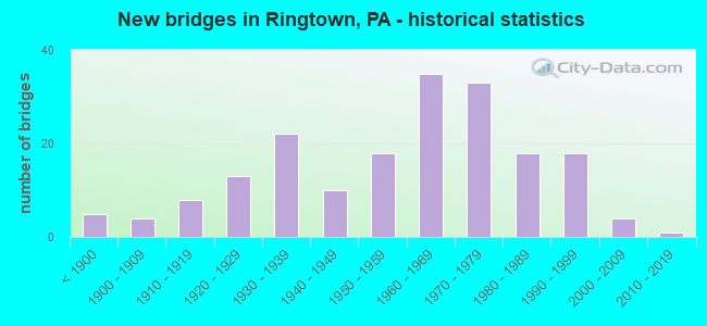
- New bridges - historical statistics
- 5Before 1900
- 41900-1909
- 81910-1919
- 131920-1929
- 221930-1939
- 101940-1949
- 181950-1959
- 351960-1969
- 331970-1979
- 181980-1989
- 181990-1999
- 42000-2009
- 12010-2019

- Reconstructed bridges - Historical Statistics
- 31930-1939
- 01940-1949
- 41950-1959
- 21960-1969
- 61970-1979
- 81980-1989
- 181990-1999
- 162000-2009
- 132010-2019


- Bridge Condition - Deck
- 9.4%Excellent
- 36.5%Very good
- 27.0%Good
- 17.6%Satisfactory
- 5.7%Fair
- 2.5%Poor
- 1.3%Serious
- 0.6%Failed

- Bridge Condition - Superstructure
- 9.5%Very good
- 31.5%Good
- 23.2%Satisfactory
- 24.4%Fair
- 10.1%Poor
- 1.2%Serious
- 0.6%Failed

- Bridge Condition - Substructure
- 1.2%Very good
- 32.1%Good
- 33.9%Satisfactory
- 27.4%Fair
- 4.2%Poor
- 1.2%Serious

- Bridge Condition - Channel
- 4.6%Very good
- 16.4%Good
- 27.6%Satisfactory
- 30.9%Fair
- 20.4%Poor

- Bridge Condition - Culverts
- 4.8%Very good
- 19.0%Good
- 42.9%Satisfactory
- 23.8%Fair
- 9.5%Poor
Find on map >> Show street view
Structure Number: 199, Location: 1.5 MI N OF HUNTERSTOWN (Lat: 39.901528, Lng: -77.155794), Route carried "on" structure: State highway , Year Built: 1926, Year Reconstructed: 2017, Status: Open, Structure Length: 0.94m (3.08ft), Average Daily Traffic: 201 (year 2022), Truck Traffic: 12%, Average Future Daily Traffic: 686 (year 2032), Design Load: HL 93, Features Intersected: BEAVERDAM CREEK, Facility Carried by Structure: SR 1017
Minimum Vertical Clearance: 30+ m (98+ ft), Kilometerpoint: 2.129, Lanes on structure: 2, Owner: State Highway Agency, Approaching Roadway Width: 9.4m (30.8ft), Material/Design: Steel, Design/Construction: Stringer/Multi-beam, Number Of Spans In Main Unit: 1, Length of Maximum Span: 8.8m (28.9ft), Curb-To-Curb Width: 9.4m (30.8ft), Out-to-Out Width: 10.1m (33.1ft)
Condition: Deck: Very good, Superstructure: Very good, Substructure: Good, Channel: Good, Inventory Rating: 63.5 metric tons, Method Used To Determine Inventory Rating: Load Factor (LF), Structural Evaluation: Better than present minimum criteria, Deck Geometry: Equal to present minimum criteria, Waterway Adequacy: Better than present minimum criteria, Approach Roadway Alignment: Equal to present desirable criteria, Length Of Structure Improvement: 1.60m (5.25ft), Designated Inspection Frequency: Every 24 months, Inspection Date: Febuary 2021, Bridge Improvement Cost: $11,000, Roadway Improvement Cost: $34,000, Total Project Cost: $153,000, Deck Structure Type: Concrete Cast-file-Place, Wearing Surface/Protective System: Wearing Surface: Monolithic Concrete, Deck Protection: Epoxy Coated Reinforcing
Find on map >> Show street view
Structure Number: 248, Location: 1 MI. E. OF KINGSDALE (Lat: 39.723889, Lng: -77.102225), Route carried "on" structure: State highway , Year Built: 1963, Status: Open, Structure Length: 0.82m (2.69ft), Average Daily Traffic: 778 (year 2022), Truck Traffic: 2%, Average Future Daily Traffic: 1,111 (year 2032), Design Load: H 20, Features Intersected: PINEY CREEK, Facility Carried by Structure: SR 2014
Minimum Vertical Clearance: 30+ m (98+ ft), Kilometerpoint: 8.972, Lanes on structure: 2, Owner: State Highway Agency, Approaching Roadway Width: 9.8m (32.2ft), Material/Design: Concrete, Design/Construction: Slab, Number Of Spans In Main Unit: 1, Length of Maximum Span: 7.3m (24.0ft), Curb or Sidewalk Widths: Left: 0.5m (1.6ft), Right: 0.5m (1.6ft), Curb-To-Curb Width: 9.1m (29.9ft), Out-to-Out Width: 10.8m (35.4ft)
Condition: Deck: Good, Superstructure: Good, Substructure: Satisfactory, Channel: Fair, Operating Rating: 57.2 metric tons, Method Used To Determine Operating Rating: Load Factor (LF), Inventory Rating: 34.5 metric tons, Method Used To Determine Inventory Rating: Load Factor (LF), Structural Evaluation: Equal to present minimum criteria, Deck Geometry: Equal to present minimum criteria, Waterway Adequacy: Superior to present desirable criteria, Approach Roadway Alignment: Equal to present desirable criteria, Length Of Structure Improvement: 1.40m (4.59ft), Designated Inspection Frequency: Every 24 months, Inspection Date: Febuary 2021, Wearing Surface/Protective System: Wearing Surface: Bituminous, Membrane: Preformed Fabric
Find on map >> Show street view
Structure Number: 383, Location: 1 MI NE OF TABLE ROCK (Lat: 39.924269, Lng: -77.209694), Route carried "on" structure: State highway , Year Built: 1985, Status: Open, Structure Length: 1.98m (6.50ft), Average Daily Traffic: 228 (year 2022), Truck Traffic: 4%, Average Future Daily Traffic: 309 (year 2032), Design Load: HS 25 or greater, Features Intersected: CONEWAGO CREEK, Facility Carried by Structure: T-502; SR 4013
Minimum Vertical Clearance: 30+ m (98+ ft), Kilometerpoint: 0.000, Lanes on structure: 2, Owner: State Highway Agency, Approaching Roadway Width: 6.1m (20.0ft), Skew: 2 degrees, Material/Design: Prestressed concrete, Design/Construction: Box Beam or Girders - Multiple, Number Of Spans In Main Unit: 1, Length of Maximum Span: 19.5m (64.0ft), Curb or Sidewalk Widths: Left: 0.2m (0.7ft), Right: 0.2m (0.7ft), Curb-To-Curb Width: 7.6m (24.9ft), Out-to-Out Width: 8.7m (28.5ft)
Condition: Deck: Fair, Superstructure: Fair, Substructure: Very good, Channel: Good, Operating Rating: 67.1 metric tons, Method Used To Determine Operating Rating: Load Factor (LF), Inventory Rating: 28.1 metric tons, Method Used To Determine Inventory Rating: Load Factor (LF), Structural Evaluation: Somewhat better than minimum adequacy, Deck Geometry: Somewhat better than minimum adequacy, Waterway Adequacy: Equal to present desirable criteria, Approach Roadway Alignment: Equal to present desirable criteria, Length Of Structure Improvement: 2.70m (8.86ft), Designated Inspection Frequency: Every 24 months, Inspection Date: June 2021, Deck Structure Type: Other, Wearing Surface/Protective System: Wearing Surface: Bituminous, Membrane: Preformed Fabric
Find on map >> Show street view
Structure Number: 642, Location: RT 0028 SB OVER 1017 (Lat: 40.557772, Lng: -79.805244), Route carried "on" structure: State highway 28, Year Built: 1970, Year Reconstructed: 2008, Status: Open, Structure Length: 3.47m (11.38ft), Average Daily Traffic: 24,309 (year 2022), Truck Traffic: 4%, Average Future Daily Traffic: 22,414 (year 2032), Design Load: HS 20, Features Intersected: SR 1017-YUTES RUN RD
Minimum Vertical Clearance: 30+ m (98+ ft), Kilometerpoint: 22.634, Lanes on structure: 2, Lanes under structure: 2, Base Highway Network: Yes, Owner: State Highway Agency, Approaching Roadway Width: 12.2m (40.0ft), Skew: 10 degrees, Material/Design: Concrete continuous, Design/Construction: Slab, Number Of Spans In Main Unit: 3, Length of Maximum Span: 13.4m (44.0ft), Curb or Sidewalk Widths: Left: 0.2m (0.7ft), Right: 0.2m (0.7ft), Curb-To-Curb Width: 11.7m (38.4ft), Out-to-Out Width: 13.0m (42.7ft)
Condition: Deck: Good, Superstructure: Good, Substructure: Satisfactory, Operating Rating: 51.7 metric tons, Method Used To Determine Operating Rating: Load Factor (LF), Inventory Rating: 30.8 metric tons, Method Used To Determine Inventory Rating: Load Factor (LF), Structural Evaluation: Equal to present minimum criteria, Deck Geometry: Equal to present minimum criteria, Underclear: Meets minimum limits, Approach Roadway Alignment: Equal to present desirable criteria, Length Of Structure Improvement: 3.50m (11.48ft), Designated Inspection Frequency: Every 24 months, Inspection Date: June 2021, Bridge Improvement Cost: $19,000, Roadway Improvement Cost: $56,000, Total Project Cost: $257,000, Deck Structure Type: Concrete Cast-file-Place, Wearing Surface/Protective System: Wearing Surface: Latex Concrete
Find on map >> Show street view
Structure Number: 753, Location: NEAR FLEMING PARK BR. (Lat: 40.489472, Lng: -80.080333), Route carried "on" structure: State highway 51, Year Built: 1900, Status: Open, Structure Length: 1.31m (4.30ft), Average Daily Traffic: 3,467 (year 2022), Truck Traffic: 11%, Average Future Daily Traffic: 13,675 (year 2032), Design Load: HS 20, Features Intersected: FILLED IN SPANDREL ARCH, Facility Carried by Structure: ISLAND AV
Minimum Vertical Clearance: 30+ m (98+ ft), Kilometerpoint: 40.261, Lanes on structure: 2, Base Highway Network: Yes, Owner: State Highway Agency, Approaching Roadway Width: 8.5m (27.9ft), Material/Design: Concrete, Design/Construction: Arch - Deck, Number Of Spans In Main Unit: 1, Length of Maximum Span: 10.1m (33.1ft), Curb or Sidewalk Widths: Left: 1.5m (4.9ft), Right: 0.9m (3.0ft), Curb-To-Curb Width: 8.5m (27.9ft), Out-to-Out Width: 10.4m (34.1ft)
Condition: Superstructure: Poor, Substructure: Poor, Operating Rating: 49.0 metric tons, Method Used To Determine Operating Rating: Field evaluation and documented engineering judgment, Inventory Rating: 32.7 metric tons, Method Used To Determine Inventory Rating: Field evaluation and documented engineering judgment, Structural Evaluation: Meets minimum limits, Deck Geometry: Meets minimum limits, Approach Roadway Alignment: Equal to present desirable criteria, Length Of Structure Improvement: 1.00m (3.28ft), Designated Inspection Frequency: Every 24 months, Inspection Date: December 2019, Bridge Improvement Cost: $10,000, Roadway Improvement Cost: $30,000, Total Project Cost: $137,000
Find on map >> Show street view
Structure Number: 852, Location: 1/2 MILE SOUTH OF SR0050 (Lat: 40.340100, Lng: -80.129442), Route carried "on" structure: Interstate 79, Year Built: 1965, Status: Open, Structure Length: 0.76m (2.49ft), Average Daily Traffic: 72,946 (year 2022), Truck Traffic: 14%, Average Future Daily Traffic: 21,895 (year 2032), Design Load: HS 20, Features Intersected: COAL RUN CREEK
Minimum Vertical Clearance: 30+ m (98+ ft), Kilometerpoint: 2.231, Lanes on structure: 4, Base Highway Network: Yes, Owner: State Highway Agency, Approaching Roadway Width: 41.5m (136.2ft), Skew: 20 degrees, Material/Design: Concrete, Design/Construction: Culvert, Number Of Spans In Main Unit: 1, Length of Maximum Span: 7.6m (24.9ft)
Condition: Channel: Fair, Culverts: Satisfactory, Operating Rating: 89.8 metric tons, Method Used To Determine Operating Rating: Field evaluation and documented engineering judgment, Inventory Rating: 89.8 metric tons, Method Used To Determine Inventory Rating: Field evaluation and documented engineering judgment, Structural Evaluation: Equal to present minimum criteria, Waterway Adequacy: Superior to present desirable criteria, Approach Roadway Alignment: Equal to present desirable criteria, Length Of Structure Improvement: 0.80m (2.62ft), Designated Inspection Frequency: Every 48 months, Inspection Date: May 2018, Bridge Improvement Cost: $72,000, Roadway Improvement Cost: $211,000, Total Project Cost: $969,000
Find on map >> Show street view
Structure Number: 854, Location: I 79 NB OVER SR 50 (Lat: 40.356158, Lng: -80.118247), Route carried "on" structure: Interstate 79, Year Built: 1965, Year Reconstructed: 1998, Status: Open, Structure Length: 5.61m (18.41ft), Average Daily Traffic: 31,325 (year 2021), Truck Traffic: 15%, Average Future Daily Traffic: 29,322 (year 2032), Design Load: HS 20, Features Intersected: SR 0050, Facility Carried by Structure: RAYMOND SHAFER HW
Minimum Vertical Clearance: 30+ m (98+ ft), Kilometerpoint: 4.635, Lanes on structure: 2, Lanes under structure: 8, Base Highway Network: Yes, Owner: State Highway Agency, Approaching Roadway Width: 12.5m (41.0ft), Skew: 14 degrees, Material/Design: Prestressed concrete, Design/Construction: Stringer/Multi-beam, Number Of Spans In Main Unit: 3, Length of Maximum Span: 33.5m (109.9ft), Curb or Sidewalk Widths: Left: 0.2m (0.7ft), Right: 0.2m (0.7ft), Curb-To-Curb Width: 13.0m (42.7ft), Out-to-Out Width: 13.0m (42.7ft)
Condition: Deck: Good, Superstructure: Good, Substructure: Satisfactory, Operating Rating: 89.8 metric tons, Method Used To Determine Operating Rating: Load Factor (LF), Inventory Rating: 9.1 metric tons, Method Used To Determine Inventory Rating: Load Factor (LF), Structural Evaluation: High priority of corrective action, Deck Geometry: Superior to present desirable criteria, Underclear: High priority of corrective action, Approach Roadway Alignment: Equal to present desirable criteria, Length Of Structure Improvement: 5.60m (18.37ft), Designated Inspection Frequency: Every 24 months, Inspection Date: May 2020, Bridge Improvement Cost: $13,000, Roadway Improvement Cost: $38,000, Total Project Cost: $174,000, Deck Structure Type: Concrete Cast-file-Place, Wearing Surface/Protective System: Wearing Surface: Latex Concrete, Deck Protection: Epoxy Coated Reinforcing
Find on map >> Show street view
Structure Number: 867, Location: 1/4 MI.SOUTH OF SR 3054 (Lat: 40.399853, Lng: -80.105656), Route carried "on" structure: Interstate 79, Year Built: 1972, Year Reconstructed: 2005, Status: Open, Structure Length: 17.86m (58.60ft), Average Daily Traffic: 36,259 (year 2022), Truck Traffic: 12%, Average Future Daily Traffic: 32,094 (year 2032), Design Load: HS 20, Features Intersected: POC RAILWAY, Facility Carried by Structure: RAYMOND SHAFER HW
Minimum Vertical Clearance: 30+ m (98+ ft), Kilometerpoint: 10.269, Lanes on structure: 3, Base Highway Network: Yes, Owner: State Highway Agency, Approaching Roadway Width: 18.0m (59.1ft), Skew: 13 degrees, Material/Design: Steel continuous, Design/Construction: Stringer/Multi-beam, Number Of Spans In Main Unit: 5, Length of Maximum Span: 38.7m (127.0ft), Curb or Sidewalk Widths: Left: 0.2m (0.7ft), Right: 0.2m (0.7ft), Curb-To-Curb Width: 17.4m (57.1ft), Out-to-Out Width: 18.6m (61.0ft)
Condition: Deck: Good, Superstructure: Good, Substructure: Satisfactory, Channel: Very good, Operating Rating: 72.6 metric tons, Method Used To Determine Operating Rating: Load Factor (LF), Inventory Rating: 43.5 metric tons, Method Used To Determine Inventory Rating: Load Factor (LF), Structural Evaluation: Equal to present minimum criteria, Deck Geometry: Better than present minimum criteria, Underclear: High priority of corrective action, Waterway Adequacy: Superior to present desirable criteria, Approach Roadway Alignment: Equal to present desirable criteria, Length Of Structure Improvement: 17.90m (58.73ft), Designated Inspection Frequency: Every 24 months, Inspection Date: September 2020, Bridge Improvement Cost: $104,000, Roadway Improvement Cost: $307,000, Total Project Cost: $1,406,000, Deck Structure Type: Concrete Cast-file-Place, Wearing Surface/Protective System: Wearing Surface: Monolithic Concrete, Deck Protection: Epoxy Coated Reinforcing
Find on map >> Show street view
Structure Number: 869, Location: .25 MI.SOUTH OF EWING RD (Lat: 40.399753, Lng: -80.106003), Route carried "on" structure: Interstate 79, Year Built: 1972, Year Reconstructed: 2006, Status: Open, Structure Length: 18.50m (60.70ft), Average Daily Traffic: 33,286 (year 2022), Truck Traffic: 12%, Average Future Daily Traffic: 29,995 (year 2032), Design Load: HS 20, Features Intersected: PITT-IND RR, ROBINSON RU, Facility Carried by Structure: RAYMOND SHAFER HW
Minimum Vertical Clearance: 30+ m (98+ ft), Kilometerpoint: 10.261, Lanes on structure: 3, Base Highway Network: Yes, Owner: State Highway Agency, Approaching Roadway Width: 14.9m (48.9ft), Skew: 10 degrees, Material/Design: Steel continuous, Design/Construction: Stringer/Multi-beam, Number Of Spans In Main Unit: 5, Length of Maximum Span: 39.6m (129.9ft), Curb or Sidewalk Widths: Left: 0.2m (0.7ft), Right: 0.2m (0.7ft), Curb-To-Curb Width: 13.7m (44.9ft), Out-to-Out Width: 14.8m (48.6ft)
Condition: Deck: Good, Superstructure: Good, Substructure: Good, Channel: Very good, Operating Rating: 71.7 metric tons, Method Used To Determine Operating Rating: Load Factor (LF), Inventory Rating: 42.6 metric tons, Method Used To Determine Inventory Rating: Load Factor (LF), Structural Evaluation: Better than present minimum criteria, Deck Geometry: Meets minimum limits, Underclear: High priority of corrective action, Waterway Adequacy: Superior to present desirable criteria, Approach Roadway Alignment: Equal to present desirable criteria, Length Of Structure Improvement: 18.20m (59.71ft), Designated Inspection Frequency: Every 24 months, Inspection Date: September 2020, Bridge Improvement Cost: $311,000, Roadway Improvement Cost: $917,000, Total Project Cost: $4,203,000, Deck Structure Type: Concrete Cast-file-Place, Wearing Surface/Protective System: Wearing Surface: Monolithic Concrete, Deck Protection: Epoxy Coated Reinforcing
Find on map >> Show street view
Structure Number: 882, Location: I-79 SB O/CAMPBELLS RN RD (Lat: 40.427356, Lng: -80.106289), Route carried "on" structure: Interstate 79, Year Built: 1973, Year Reconstructed: 2006, Status: Open, Structure Length: 2.07m (6.79ft), Average Daily Traffic: 31,419 (year 2021), Truck Traffic: 14%, Average Future Daily Traffic: 12,989 (year 2032), Design Load: HS 20, Features Intersected: CAMPBELLS RUN RD, Facility Carried by Structure: RAYMOND P SHAFE HY
Minimum Vertical Clearance: 30+ m (98+ ft), Kilometerpoint: 13.481, Lanes on structure: 2, Lanes under structure: 2, Base Highway Network: Yes, Owner: State Highway Agency, Approaching Roadway Width: 16.2m (53.1ft), Skew: 11 degrees, Material/Design: Prestressed concrete, Design/Construction: Box Beam or Girders - Multiple, Number Of Spans In Main Unit: 1, Length of Maximum Span: 20.1m (65.9ft), Curb or Sidewalk Widths: Left: 0.2m (0.7ft), Right: 0.2m (0.7ft), Curb-To-Curb Width: 16.3m (53.5ft), Out-to-Out Width: 17.4m (57.1ft)
Condition: Deck: Good, Superstructure: Good, Substructure: Good, Inventory Rating: 68.9 metric tons, Method Used To Determine Inventory Rating: Load Factor (LF), Structural Evaluation: Better than present minimum criteria, Deck Geometry: Superior to present desirable criteria, Underclear: Better than present minimum criteria, Approach Roadway Alignment: Equal to present desirable criteria, Length Of Structure Improvement: 2.10m (6.89ft), Designated Inspection Frequency: Every 24 months, Inspection Date: May 2020, Deck Structure Type: Concrete Cast-file-Place, Wearing Surface/Protective System: Wearing Surface: Monolithic Concrete, Deck Protection: Epoxy Coated Reinforcing
Find on map >> Show street view
Structure Number: 886, Location: I-79 NB OVER SR 0060 (Lat: 40.450144, Lng: -80.110747), Route carried "on" structure: Interstate 79, Year Built: 1971, Year Reconstructed: 1997, Status: Open, Structure Length: 5.88m (19.29ft), Average Daily Traffic: 24,433 (year 2021), Truck Traffic: 20%, Average Future Daily Traffic: 17,543 (year 2032), Design Load: HS 20, Features Intersected: SR 0060, Facility Carried by Structure: RAYMOND SHAFER HW
Minimum Vertical Clearance: 30+ m (98+ ft), Kilometerpoint: 16.707, Lanes on structure: 2, Lanes under structure: 14, Base Highway Network: Yes, Owner: State Highway Agency, Approaching Roadway Width: 12.2m (40.0ft), Skew: 10 degrees, Material/Design: Prestressed concrete continuous, Design/Construction: Stringer/Multi-beam, Number Of Spans In Main Unit: 3, Length of Maximum Span: 32.6m (107.0ft), Curb or Sidewalk Widths: Left: 0.2m (0.7ft), Right: 0.2m (0.7ft), Curb-To-Curb Width: 12.2m (40.0ft), Out-to-Out Width: 13.3m (43.6ft)
Condition: Deck: Good, Superstructure: Fair, Substructure: Fair, Operating Rating: 69.9 metric tons, Method Used To Determine Operating Rating: Load Factor (LF), Inventory Rating: 30.8 metric tons, Method Used To Determine Inventory Rating: Load Factor (LF), Structural Evaluation: Somewhat better than minimum adequacy, Deck Geometry: Better than present minimum criteria, Underclear: Meets minimum limits, Approach Roadway Alignment: Equal to present desirable criteria, Length Of Structure Improvement: 5.90m (19.36ft), Designated Inspection Frequency: Every 24 months, Inspection Date: May 2020, Deck Structure Type: Concrete Cast-file-Place, Wearing Surface/Protective System: Wearing Surface: Monolithic Concrete, Deck Protection: Epoxy Coated Reinforcing
Find on map >> Show street view
Structure Number: 887, Location: I-79 SB OVER SR 0376 (Lat: 40.450147, Lng: -80.111081), Route carried "on" structure: Interstate 79, Year Built: 1971, Year Reconstructed: 1997, Status: Open, Structure Length: 5.88m (19.29ft), Average Daily Traffic: 24,562 (year 2021), Truck Traffic: 17%, Average Future Daily Traffic: 17,293 (year 2032), Design Load: HS 20, Features Intersected: SR 0060, Facility Carried by Structure: RAYMOND SHAFER HW
Minimum Vertical Clearance: 30+ m (98+ ft), Kilometerpoint: 16.716, Lanes on structure: 3, Lanes under structure: 14, Base Highway Network: Yes, Owner: State Highway Agency, Approaching Roadway Width: 15.8m (51.8ft), Skew: 10 degrees, Material/Design: Prestressed concrete continuous, Design/Construction: Stringer/Multi-beam, Number Of Spans In Main Unit: 3, Length of Maximum Span: 32.6m (107.0ft), Curb or Sidewalk Widths: Left: 0.2m (0.7ft), Right: 0.2m (0.7ft), Curb-To-Curb Width: 15.8m (51.8ft), Out-to-Out Width: 16.9m (55.4ft)
Condition: Deck: Good, Superstructure: Satisfactory, Substructure: Satisfactory, Operating Rating: 84.4 metric tons, Method Used To Determine Operating Rating: Load Factor (LF), Inventory Rating: 38.1 metric tons, Method Used To Determine Inventory Rating: Load Factor (LF), Structural Evaluation: Equal to present minimum criteria, Deck Geometry: Somewhat better than minimum adequacy, Underclear: Meets minimum limits, Approach Roadway Alignment: Equal to present desirable criteria, Length Of Structure Improvement: 5.60m (18.37ft), Designated Inspection Frequency: Every 24 months, Inspection Date: May 2020, Deck Structure Type: Concrete Cast-file-Place, Wearing Surface/Protective System: Wearing Surface: Monolithic Concrete, Deck Protection: Epoxy Coated Reinforcing
Find on map >> Show street view
Structure Number: 889, Location: I 79 NB OVER CLEVER RD (Lat: 40.464983, Lng: -80.111542), Route carried "on" structure: Interstate 79, Year Built: 1971, Year Reconstructed: 2001, Status: Open, Structure Length: 6.68m (21.92ft), Average Daily Traffic: 24,433 (year 2021), Truck Traffic: 20%, Average Future Daily Traffic: 17,543 (year 2032), Design Load: HS 20, Features Intersected: CLEVER RD, Facility Carried by Structure: RAYMOND SHAFER HW
Minimum Vertical Clearance: 30+ m (98+ ft), Kilometerpoint: 18.321, Lanes on structure: 2, Lanes under structure: 2, Base Highway Network: Yes, Owner: State Highway Agency, Approaching Roadway Width: 11.9m (39.0ft), Skew: 13 degrees, Material/Design: Prestressed concrete, Design/Construction: Stringer/Multi-beam, Number Of Spans In Main Unit: 3, Length of Maximum Span: 31.1m (102.0ft), Curb or Sidewalk Widths: Left: 0.2m (0.7ft), Right: 0.2m (0.7ft), Curb-To-Curb Width: 12.2m (40.0ft), Out-to-Out Width: 13.4m (44.0ft)
Condition: Deck: Good, Superstructure: Satisfactory, Substructure: Good, Operating Rating: 72.6 metric tons, Method Used To Determine Operating Rating: Load Factor (LF), Inventory Rating: 13.6 metric tons, Method Used To Determine Inventory Rating: Load Factor (LF), Structural Evaluation: High priority of corrective action, Deck Geometry: Better than present minimum criteria, Underclear: Meets minimum limits, Approach Roadway Alignment: Equal to present desirable criteria, Length Of Structure Improvement: 6.70m (21.98ft), Designated Inspection Frequency: Every 24 months, Inspection Date: May 2020, Bridge Improvement Cost: $93,000, Roadway Improvement Cost: $273,000, Total Project Cost: $1,253,000, Deck Structure Type: Concrete Cast-file-Place, Wearing Surface/Protective System: Wearing Surface: Latex Concrete, Deck Protection: Epoxy Coated Reinforcing
Find on map >> Show street view
Structure Number: 89, Location: I-79 SB OVER CLEVER ROAD (Lat: 40.465106, Lng: -80.111906), Route carried "on" structure: Interstate 79, Year Built: 1971, Year Reconstructed: 1982, Status: Open, Structure Length: 8.05m (26.41ft), Average Daily Traffic: 24,562 (year 2021), Truck Traffic: 17%, Average Future Daily Traffic: 17,293 (year 2032), Design Load: HS 20, Features Intersected: CLEVER RD, Facility Carried by Structure: RAYMOND SHAFER HW
Minimum Vertical Clearance: 30+ m (98+ ft), Kilometerpoint: 18.327, Lanes on structure: 2, Lanes under structure: 2, Base Highway Network: Yes, Owner: State Highway Agency, Approaching Roadway Width: 12.2m (40.0ft), Skew: 14 degrees, Material/Design: Prestressed concrete, Design/Construction: Stringer/Multi-beam, Number Of Spans In Main Unit: 3, Length of Maximum Span: 33.5m (109.9ft), Curb or Sidewalk Widths: Left: 0.2m (0.7ft), Right: 0.2m (0.7ft), Curb-To-Curb Width: 12.3m (40.4ft), Out-to-Out Width: 13.4m (44.0ft)
Condition: Deck: Good, Superstructure: Satisfactory, Substructure: Good, Operating Rating: 64.4 metric tons, Method Used To Determine Operating Rating: Load Factor (LF), Inventory Rating: 1.8 metric tons, Method Used To Determine Inventory Rating: Load Factor (LF), Structural Evaluation: High priority of corrective action, Deck Geometry: Better than present minimum criteria, Underclear: Meets minimum limits, Approach Roadway Alignment: Equal to present desirable criteria, Length Of Structure Improvement: 8.00m (26.25ft), Designated Inspection Frequency: Every 24 months, Inspection Date: May 2020, Bridge Improvement Cost: $98,000, Roadway Improvement Cost: $288,000, Total Project Cost: $1,320,000, Deck Structure Type: Concrete Cast-file-Place, Wearing Surface/Protective System: Wearing Surface: Latex Concrete, Deck Protection: Epoxy Coated Reinforcing
Find on map >> Show street view
Structure Number: 891, Location: I-79 SB1.4 MI N OF SR 60 (Lat: 40.469733, Lng: -80.115331), Route carried "on" structure: Interstate 79, Year Built: 1973, Status: Open, Structure Length: 0.64m (2.10ft), Average Daily Traffic: 24,562 (year 2021), Truck Traffic: 17%, Average Future Daily Traffic: 17,293 (year 2032), Design Load: HS 20, Features Intersected: MOON RUN, Facility Carried by Structure: RAYMOND SHAFER HWY
Minimum Vertical Clearance: 30+ m (98+ ft), Kilometerpoint: 19.111, Lanes on structure: 2, Base Highway Network: Yes, Owner: State Highway Agency, Approaching Roadway Width: 12.2m (40.0ft), Skew: 6 degrees, Material/Design: Concrete, Design/Construction: Culvert, Number Of Spans In Main Unit: 1, Length of Maximum Span: 6.4m (21.0ft)
Condition: Channel: Satisfactory, Culverts: Satisfactory, Inventory Rating: 99.8 metric tons, Method Used To Determine Inventory Rating: Field evaluation and documented engineering judgment, Structural Evaluation: Equal to present minimum criteria, Waterway Adequacy: Superior to present desirable criteria, Approach Roadway Alignment: Equal to present desirable criteria, Length Of Structure Improvement: 1.20m (3.94ft), Designated Inspection Frequency: Every 48 months, Inspection Date: May 2018
Find on map >> Show street view
Structure Number: 892, Location: I-79 NB AT TURN-AROUND (Lat: 40.501786, Lng: -80.126883), Route carried "on" structure: Interstate 79, Year Built: 1971, Status: Open, Structure Length: 0.98m (3.22ft), Average Daily Traffic: 48,995 (year 2021), Truck Traffic: 19%, Average Future Daily Traffic: 34,836 (year 2032), Design Load: HS 20, Features Intersected: MOON RUN, Facility Carried by Structure: RAYMOND SHAFER HW
Minimum Vertical Clearance: 30+ m (98+ ft), Kilometerpoint: 23.152, Lanes on structure: 2, Base Highway Network: Yes, Owner: State Highway Agency, Approaching Roadway Width: 18.3m (60.0ft), Skew: 5 degrees, Material/Design: Concrete, Design/Construction: Culvert, Number Of Spans In Main Unit: 1, Length of Maximum Span: 9.8m (32.2ft)
Condition: Channel: Satisfactory, Culverts: Satisfactory, Operating Rating: 49.0 metric tons, Method Used To Determine Operating Rating: Field evaluation and documented engineering judgment, Inventory Rating: 32.7 metric tons, Method Used To Determine Inventory Rating: Field evaluation and documented engineering judgment, Structural Evaluation: Equal to present minimum criteria, Waterway Adequacy: Superior to present desirable criteria, Approach Roadway Alignment: Equal to present desirable criteria, Length Of Structure Improvement: 1.60m (5.25ft), Designated Inspection Frequency: Every 48 months, Inspection Date: May 2018
Find on map >> Show street view
Structure Number: 894, Location: GROVETON-I79 NB OVER TR51 (Lat: 40.503617, Lng: -80.137217), Route carried "on" structure: Interstate 79, Year Built: 1974, Status: Open, Structure Length: 5.58m (18.31ft), Average Daily Traffic: 22,960 (year 2020), Truck Traffic: 22%, Average Future Daily Traffic: 19,859 (year 2032), Design Load: HS 20, Features Intersected: SR 0051 AT GROVETON, Facility Carried by Structure: RAYMOND SHAFER HW
Minimum Vertical Clearance: 30+ m (98+ ft), Kilometerpoint: 23.957, Lanes on structure: 2, Lanes under structure: 8, Base Highway Network: Yes, Owner: State Highway Agency, Approaching Roadway Width: 12.2m (40.0ft), Skew: 14 degrees, Material/Design: Steel, Design/Construction: Stringer/Multi-beam, Number Of Spans In Main Unit: 1, Number Of Approach Spans: 2, Length of Maximum Span: 32.6m (107.0ft), Curb or Sidewalk Widths: Left: 0.2m (0.7ft), Right: 0.2m (0.7ft), Curb-To-Curb Width: 12.2m (40.0ft), Out-to-Out Width: 13.4m (44.0ft)
Condition: Deck: Good, Superstructure: Good, Substructure: Good, Operating Rating: 49.0 metric tons, Method Used To Determine Operating Rating: Load Factor (LF), Inventory Rating: 29.0 metric tons, Method Used To Determine Inventory Rating: Load Factor (LF), Structural Evaluation: Better than present minimum criteria, Deck Geometry: Better than present minimum criteria, Underclear: Equal to present minimum criteria, Approach Roadway Alignment: Equal to present desirable criteria, Length Of Structure Improvement: 5.60m (18.37ft), Designated Inspection Frequency: Every 24 months, Inspection Date: May 2020, Bridge Improvement Cost: $17,000, Roadway Improvement Cost: $59,000, Total Project Cost: $225,000, Deck Structure Type: Concrete Cast-file-Place, Wearing Surface/Protective System: Wearing Surface: Monolithic Concrete
Find on map >> Show street view
Structure Number: 895, Location: 200 FT NORTH OF SR 51 (Lat: 40.504308, Lng: -80.137522), Route carried "on" structure: Interstate 79, Year Built: 1972, Status: Open, Structure Length: 0.91m (2.99ft), Average Daily Traffic: 40,587 (year 2020), Truck Traffic: 23%, Average Future Daily Traffic: 39,913 (year 2032), Design Load: HS 20, Features Intersected: MOON RUN
Minimum Vertical Clearance: 30+ m (98+ ft), Kilometerpoint: 23.957, Lanes on structure: 6, Base Highway Network: Yes, Owner: State Highway Agency, Approaching Roadway Width: 36.6m (120.1ft), Skew: 36 degrees, Material/Design: Concrete, Design/Construction: Culvert, Number Of Spans In Main Unit: 1, Length of Maximum Span: 9.1m (29.9ft)
Condition: Channel: Good, Culverts: Satisfactory, Inventory Rating: 99.8 metric tons, Method Used To Determine Inventory Rating: Field evaluation and documented engineering judgment, Structural Evaluation: Equal to present minimum criteria, Waterway Adequacy: Superior to present desirable criteria, Approach Roadway Alignment: Equal to present desirable criteria, Length Of Structure Improvement: 0.90m (2.95ft), Designated Inspection Frequency: Every 48 months, Inspection Date: May 2018, Bridge Improvement Cost: $84,000, Roadway Improvement Cost: $249,000, Total Project Cost: $1,139,000
Find on map >> Show street view
Structure Number: 958, Location: 300FT SW OF SR 2013 (Lat: 40.205328, Lng: -79.858689), Route carried "on" structure: State highway 136, Year Built: 1930, Status: Open, Structure Length: 0.85m (2.79ft), Average Daily Traffic: 4,858 (year 2022), Truck Traffic: 10%, Average Future Daily Traffic: 6,638 (year 2032), Design Load: HS 20, Features Intersected: BECKETS RUN, Facility Carried by Structure: MONONGAHELA ROAD
Minimum Vertical Clearance: 30+ m (98+ ft), Kilometerpoint: 4.884, Lanes on structure: 2, Owner: State Highway Agency, Approaching Roadway Width: 11.6m (38.1ft), Skew: 3 degrees, Material/Design: Steel, Design/Construction: Stringer/Multi-beam, Number Of Spans In Main Unit: 1, Length of Maximum Span: 7.3m (24.0ft), Curb-To-Curb Width: 11.6m (38.1ft), Out-to-Out Width: 12.2m (40.0ft)
Condition: Deck: Satisfactory, Superstructure: Fair, Substructure: Fair, Channel: Fair, Operating Rating: 59.9 metric tons, Method Used To Determine Operating Rating: Load Factor (LF), Inventory Rating: 35.4 metric tons, Method Used To Determine Inventory Rating: Load Factor (LF), Structural Evaluation: Somewhat better than minimum adequacy, Deck Geometry: Somewhat better than minimum adequacy, Waterway Adequacy: Equal to present minimum criteria, Approach Roadway Alignment: Equal to present desirable criteria, Length Of Structure Improvement: 0.90m (2.95ft), Designated Inspection Frequency: Every 24 months, Inspection Date: January 2020, Bridge Improvement Cost: $7,000, Roadway Improvement Cost: $21,000, Total Project Cost: $90,000, Deck Structure Type: Concrete Cast-file-Place, Wearing Surface/Protective System: Wearing Surface: Bituminous
Find on map >> Show street view
Structure Number: 1266, Location: 100 FT NE OF SR 3021 (Lat: 40.259039, Lng: -79.915164), Route carried "on" structure: State highway 837, Year Built: 1952, Status: Open, Structure Length: 0.85m (2.79ft), Average Daily Traffic: 7,506 (year 2022), Truck Traffic: 12%, Average Future Daily Traffic: 8,055 (year 2032), Design Load: HS 20, Features Intersected: LOBBS RUN, Facility Carried by Structure: RIVER ROAD
Minimum Vertical Clearance: 30+ m (98+ ft), Kilometerpoint: 0.829, Lanes on structure: 2, Base Highway Network: Yes, Owner: State Highway Agency, Approaching Roadway Width: 12.2m (40.0ft), Skew: 3 degrees, Material/Design: Concrete, Design/Construction: Culvert, Number Of Spans In Main Unit: 1, Length of Maximum Span: 8.5m (27.9ft)
Condition: Channel: Satisfactory, Culverts: Satisfactory, Operating Rating: 49.0 metric tons, Method Used To Determine Operating Rating: Field evaluation and documented engineering judgment, Inventory Rating: 32.7 metric tons, Method Used To Determine Inventory Rating: Field evaluation and documented engineering judgment, Structural Evaluation: Equal to present minimum criteria, Waterway Adequacy: Superior to present desirable criteria, Approach Roadway Alignment: Equal to present desirable criteria, Length Of Structure Improvement: 0.90m (2.95ft), Designated Inspection Frequency: Every 48 months, Inspection Date: July 2019
Find on map >> Show street view
Structure Number: 1459, Location: @ INTER.W/TWP.RD.701 (Lat: 40.666994, Lng: -79.735164), Route carried "on" structure: State highway , Year Built: 1900, Status: Open, Structure Length: 0.61m (2.00ft), Average Daily Traffic: 2,722 (year 2020), Truck Traffic: 7%, Average Future Daily Traffic: 3,115 (year 2032), Design Load: HS 20, Features Intersected: LITTLE BULL CREEK, Facility Carried by Structure: BAKERSTOWN RD
Minimum Vertical Clearance: 30+ m (98+ ft), Kilometerpoint: 18.366, Lanes on structure: 2, Owner: State Highway Agency, Approaching Roadway Width: 10.4m (34.1ft), Skew: 2 degrees, Material/Design: Masonry, Design/Construction: Culvert, Number Of Spans In Main Unit: 1, Length of Maximum Span: 6.1m (20.0ft)
Condition: Channel: Poor, Culverts: Poor, Operating Rating: 49.0 metric tons, Method Used To Determine Operating Rating: Field evaluation and documented engineering judgment, Inventory Rating: 32.7 metric tons, Method Used To Determine Inventory Rating: Field evaluation and documented engineering judgment, Structural Evaluation: Meets minimum limits, Waterway Adequacy: Equal to present minimum criteria, Approach Roadway Alignment: Equal to present desirable criteria, Length Of Structure Improvement: 0.70m (2.30ft), Designated Inspection Frequency: Every 24 months, Other Special Inspection Frequency: Every 12 months, Inspection Date: March 2021, Other Special Inspection Date: March 2021, Bridge Improvement Cost: $6,000, Roadway Improvement Cost: $19,000, Total Project Cost: $78,000
Find on map >> Show street view
Structure Number: 1845, Location: 1 MI. S.W. OF SR 0030 (Lat: 40.483206, Lng: -80.357706), Route carried "on" structure: Spur State highway , Year Built: 1936, Status: Open, Structure Length: 0.76m (2.49ft), Average Daily Traffic: 1,464 (year 2022), Truck Traffic: 4%, Average Future Daily Traffic: 1,997 (year 2032), Design Load: HS 20, Features Intersected: BR.RACCOON CREEK, Facility Carried by Structure: MURDOCKSVILLE ROAD
Minimum Vertical Clearance: 30+ m (98+ ft), Kilometerpoint: 0.702, Lanes on structure: 2, Owner: State Highway Agency, Approaching Roadway Width: 7.3m (24.0ft), Material/Design: Masonry, Design/Construction: Arch - Deck, Number Of Spans In Main Unit: 1, Length of Maximum Span: 7.6m (24.9ft), Curb-To-Curb Width: 4.9m (16.1ft), Out-to-Out Width: 5.8m (19.0ft)
Condition: Superstructure: Poor, Substructure: Fair, Channel: Satisfactory, Operating Rating: 49.0 metric tons, Method Used To Determine Operating Rating: Field evaluation and documented engineering judgment, Inventory Rating: 32.7 metric tons, Method Used To Determine Inventory Rating: Field evaluation and documented engineering judgment, Structural Evaluation: Meets minimum limits, Deck Geometry: High priority of replacement, Waterway Adequacy: Equal to present desirable criteria, Approach Roadway Alignment: Equal to present desirable criteria, Length Of Structure Improvement: 0.80m (2.62ft), Designated Inspection Frequency: Every 24 months, Other Special Inspection Frequency: Every 12 months, Inspection Date: March 2021, Other Special Inspection Date: March 2021, Bridge Improvement Cost: $6,000, Roadway Improvement Cost: $25,000, Total Project Cost: $75,000
Find on map >> Show street view
Structure Number: 1848, Location: OVER SR 3160 (Lat: 40.518750, Lng: -80.303731), Route carried "on" structure: State highway , Year Built: 1970, Year Reconstructed: 2017, Status: Open, Structure Length: 8.35m (27.40ft), Average Daily Traffic: 521 (year 2022), Truck Traffic: 15%, Average Future Daily Traffic: 3,789 (year 2032), Design Load: HL 93, Features Intersected: BUSINESS 376, Facility Carried by Structure: HOOKSTOWN GRADE RD
Minimum Vertical Clearance: 30+ m (98+ ft), Kilometerpoint: 0.105, Lanes on structure: 2, Lanes under structure: 12, Owner: State Highway Agency, Approaching Roadway Width: 14.3m (46.9ft), Skew: 3 degrees, Material/Design: Prestressed concrete, Design/Construction: Stringer/Multi-beam, Number Of Spans In Main Unit: 4, Length of Maximum Span: 28.0m (91.9ft), Curb or Sidewalk Widths: Left: 0.2m (0.7ft), Right: 0.2m (0.7ft), Curb-To-Curb Width: 13.4m (44.0ft), Out-to-Out Width: 14.6m (47.9ft)
Condition: Deck: Very good, Superstructure: Very good, Substructure: Good, Operating Rating: 47.2 metric tons, Method Used To Determine Operating Rating: Assigned ratings based on Load and Resistance Factor Design (LRFD) reported in metric tons, Inventory Rating: 20.0 metric tons, Method Used To Determine Inventory Rating: Assigned ratings based on Load and Resistance Factor Design (LRFD) reported in metric tons, Structural Evaluation: Somewhat better than minimum adequacy, Deck Geometry: Superior to present desirable criteria, Underclear: High priority of corrective action, Approach Roadway Alignment: Equal to present desirable criteria, Length Of Structure Improvement: 8.40m (27.56ft), Designated Inspection Frequency: Every 24 months, Inspection Date: October 2019, Bridge Improvement Cost: $69,000, Roadway Improvement Cost: $204,000, Total Project Cost: $934,000, Deck Structure Type: Concrete Cast-file-Place, Wearing Surface/Protective System: Wearing Surface: Monolithic Concrete, Deck Protection: Epoxy Coated Reinforcing
Find on map >> Show street view
Structure Number: 1849, Location: NEAR SR 3071 INTERSECTION (Lat: 40.468806, Lng: -80.305422), Route carried "on" structure: State highway , Year Built: 1941, Year Reconstructed: 2013, Status: Open, Structure Length: 0.98m (3.22ft), Average Daily Traffic: 604 (year 2020), Truck Traffic: 16%, Average Future Daily Traffic: 907 (year 2032), Design Load: HS 20, Features Intersected: POTATO GARDEN RD, Facility Carried by Structure: WASHINGTON RD
Minimum Vertical Clearance: 30+ m (98+ ft), Kilometerpoint: 2.417, Lanes on structure: 2, Owner: State Highway Agency, Approaching Roadway Width: 7.9m (25.9ft), Skew: 4 degrees, Material/Design: Concrete, Design/Construction: Slab, Number Of Spans In Main Unit: 1, Length of Maximum Span: 8.8m (28.9ft), Curb-To-Curb Width: 7.9m (25.9ft), Out-to-Out Width: 8.8m (28.9ft)
Condition: Deck: Very good, Superstructure: Very good, Substructure: Good, Channel: Good, Operating Rating: 77.1 metric tons, Method Used To Determine Operating Rating: Load Factor (LF), Inventory Rating: 46.3 metric tons, Method Used To Determine Inventory Rating: Load Factor (LF), Structural Evaluation: Better than present minimum criteria, Deck Geometry: Somewhat better than minimum adequacy, Waterway Adequacy: Equal to present minimum criteria, Approach Roadway Alignment: Equal to present desirable criteria, Length Of Structure Improvement: 0.90m (2.95ft), Designated Inspection Frequency: Every 24 months, Inspection Date: November 2019, Bridge Improvement Cost: $15,000, Roadway Improvement Cost: $43,000, Total Project Cost: $197,000, Deck Structure Type: Concrete Cast-file-Place, Wearing Surface/Protective System: Wearing Surface: Monolithic Concrete, Deck Protection: Epoxy Coated Reinforcing
Find on map >> Show street view
Structure Number: 1937, Location: 3000' NORTH OF SR 4022 (Lat: 40.545925, Lng: -80.054506), Route carried "on" structure: State highway , Year Built: 1941, Status: Open, Structure Length: 1.89m (6.20ft), Average Daily Traffic: 4,781 (year 2022), Truck Traffic: 2%, Average Future Daily Traffic: 6,949 (year 2032), Design Load: HS 20, Features Intersected: LOWRIES RUN, Facility Carried by Structure: ROCHESTER RD.
Minimum Vertical Clearance: 30+ m (98+ ft), Kilometerpoint: 7.913, Lanes on structure: 2, Owner: State Highway Agency, Approaching Roadway Width: 8.5m (27.9ft), Skew: 4 degrees, Material/Design: Concrete, Design/Construction: Culvert, Number Of Spans In Main Unit: 2, Length of Maximum Span: 9.1m (29.9ft), Curb or Sidewalk Widths: Left: 0.4m (1.3ft), Right: 0.4m (1.3ft), Curb-To-Curb Width: 13.4m (44.0ft), Out-to-Out Width: 15.4m (50.5ft)
Condition: Channel: Fair, Culverts: Fair, Operating Rating: 49.0 metric tons, Method Used To Determine Operating Rating: Field evaluation and documented engineering judgment, Inventory Rating: 32.7 metric tons, Method Used To Determine Inventory Rating: Field evaluation and documented engineering judgment, Structural Evaluation: Somewhat better than minimum adequacy, Deck Geometry: Better than present minimum criteria, Waterway Adequacy: Better than present minimum criteria, Approach Roadway Alignment: Equal to present desirable criteria, Length Of Structure Improvement: 1.90m (6.23ft), Designated Inspection Frequency: Every 24 months, Inspection Date: Febuary 2020, Bridge Improvement Cost: $30,000, Roadway Improvement Cost: $89,000, Total Project Cost: $407,000
Find on map >> Show street view
Structure Number: 2002, Location: WEXFORD RUN ROAD (Lat: 40.641733, Lng: -80.097358), Route carried "on" structure: State highway , Year Built: 1974, Status: Open, Structure Length: 7.35m (24.11ft), Average Daily Traffic: 2,009 (year 2022), Truck Traffic: 5%, Average Future Daily Traffic: 1,930 (year 2032), Design Load: HS 20, Features Intersected: SR 0079 NB SB, Facility Carried by Structure: WEXFORD RUN RD
Minimum Vertical Clearance: 30+ m (98+ ft), Kilometerpoint: 4.434, Lanes on structure: 2, Lanes under structure: 6, Owner: State Highway Agency, Approaching Roadway Width: 10.4m (34.1ft), Skew: 1 degrees, Material/Design: Steel continuous, Design/Construction: Stringer/Multi-beam, Number Of Spans In Main Unit: 2, Length of Maximum Span: 39.6m (129.9ft), Curb or Sidewalk Widths: Left: 0.2m (0.7ft), Right: 0.2m (0.7ft), Curb-To-Curb Width: 12.8m (42.0ft), Out-to-Out Width: 14.0m (45.9ft)
Condition: Deck: Fair, Superstructure: Satisfactory, Substructure: Fair, Operating Rating: 51.7 metric tons, Method Used To Determine Operating Rating: Load Factor (LF), Inventory Rating: 30.8 metric tons, Method Used To Determine Inventory Rating: Load Factor (LF), Structural Evaluation: Somewhat better than minimum adequacy, Deck Geometry: Equal to present minimum criteria, Underclear: Equal to present minimum criteria, Approach Roadway Alignment: Equal to present minimum criteria, Length Of Structure Improvement: 7.30m (23.95ft), Designated Inspection Frequency: Every 24 months, Inspection Date: October 2019, Bridge Improvement Cost: $16,000, Roadway Improvement Cost: $48,000, Total Project Cost: $218,000, Deck Structure Type: Concrete Cast-file-Place, Wearing Surface/Protective System: Wearing Surface: Monolithic Concrete
Find on map >> Show street view
Structure Number: 2065, Location: HAMPTON-TPK RP.AB O/TRE 8 (Lat: 40.616667, Lng: -79.950000), Route carried "on" structure: Ramp Interstate 76, Year Built: 1950, Year Reconstructed: 1995, Status: Open, Structure Length: 2.77m (9.09ft), Average Daily Traffic: 8,559 (year 1993), Truck Traffic: 8%, Average Future Daily Traffic: 13,308 (year 2030), Design Load: HS 15, Features Intersected: SR 0008, LR72
Minimum Vertical Clearance: 30+ m (98+ ft), Kilometerpoint: 0.000, Lanes on structure: 2, Lanes under structure: 10, Base Highway Network: Yes, Owner: State Toll Authority, Approaching Roadway Width: 13.4m (44.0ft), Skew: 30 degrees, Material/Design: Steel, Design/Construction: Girder and Floorbeam System, Number Of Spans In Main Unit: 1, Length of Maximum Span: 26.2m (86.0ft), Curb or Sidewalk Widths: Left: 0.2m (0.7ft), Right: 0.2m (0.7ft), Curb-To-Curb Width: 11.1m (36.4ft), Out-to-Out Width: 13.7m (44.9ft)
Condition: Deck: Good, Superstructure: Fair, Substructure: Satisfactory, Operating Rating: 87.1 metric tons, Method Used To Determine Operating Rating: Load Factor (LF), Inventory Rating: 51.7 metric tons, Method Used To Determine Inventory Rating: Load Factor (LF), Structural Evaluation: Somewhat better than minimum adequacy, Deck Geometry: Equal to present desirable criteria, Underclear: Meets minimum limits, Approach Roadway Alignment: Equal to present minimum criteria, Length Of Structure Improvement: 2.90m (9.51ft), Designated Inspection Frequency: Every 24 months, Critical Feature Inspection Frequency: Every 24 months, Inspection Date: April 2020, Critical Feature Inspection Date: April 2020, Bridge Improvement Cost: $64,000, Roadway Improvement Cost: $190,000, Total Project Cost: $869,000, Deck Structure Type: Concrete Cast-file-Place, Wearing Surface/Protective System: Wearing Surface: Latex Concrete
Find on map >> Show street view
Structure Number: 2066, Location: BUTLER VALLEY INTERCHANGE (Lat: 40.609025, Lng: -79.947219), Route carried "on" structure: State highway 8, Year Built: 1952, Year Reconstructed: 1995, Status: Open, Structure Length: 3.69m (12.11ft), Average Daily Traffic: 24,248 (year 2022), Truck Traffic: 7%, Average Future Daily Traffic: 26,350 (year 2030), Design Load: HS 20, Features Intersected: PA TPK (I-76)
Minimum Vertical Clearance: 30+ m (98+ ft), Kilometerpoint: 25.899, Lanes on structure: 4, Lanes under structure: 5, Base Highway Network: Yes, Owner: State Toll Authority, Approaching Roadway Width: 18.9m (62.0ft), Skew: 22 degrees, Material/Design: Steel, Design/Construction: Stringer/Multi-beam, Number Of Spans In Main Unit: 1, Length of Maximum Span: 35.1m (115.2ft), Curb or Sidewalk Widths: Left: 0.2m (0.7ft), Right: 0.2m (0.7ft), Curb-To-Curb Width: 21.3m (69.9ft), Out-to-Out Width: 22.3m (73.2ft)
Condition: Deck: Satisfactory, Superstructure: Good, Substructure: Satisfactory, Operating Rating: 92.5 metric tons, Method Used To Determine Operating Rating: Load Factor (LF), Inventory Rating: 55.3 metric tons, Method Used To Determine Inventory Rating: Load Factor (LF), Structural Evaluation: Equal to present minimum criteria, Deck Geometry: Superior to present desirable criteria, Underclear: Equal to present minimum criteria, Approach Roadway Alignment: Equal to present desirable criteria, Length Of Structure Improvement: 4.60m (15.09ft), Designated Inspection Frequency: Every 48 months, Inspection Date: April 2018, Bridge Improvement Cost: $77,000, Roadway Improvement Cost: $227,000, Total Project Cost: $1,042,000, Deck Structure Type: Concrete Cast-file-Place, Wearing Surface/Protective System: Wearing Surface: Monolithic Concrete
Find on map >> Show street view
Structure Number: 2945, Location: HORSESHOE ROAD (Lat: 40.712614, Lng: -79.687389), Route carried "on" structure: State highway , Year Built: 1971, Status: Open, Structure Length: 9.42m (30.91ft), Average Daily Traffic: 181 (year 2022), Truck Traffic: 8%, Average Future Daily Traffic: 233 (year 2032), Design Load: HS 20, Features Intersected: SR0028 NB&SB, Facility Carried by Structure: SR3029 (T-300)
Minimum Vertical Clearance: 30+ m (98+ ft), Kilometerpoint: 0.000, Lanes on structure: 2, Lanes under structure: 4, Owner: State Highway Agency, Approaching Roadway Width: 6.7m (22.0ft), Skew: 1 degrees, Material/Design: Prestressed concrete, Design/Construction: Stringer/Multi-beam, Number Of Spans In Main Unit: 4, Length of Maximum Span: 30.5m (100.1ft), Curb or Sidewalk Widths: Left: 0.2m (0.7ft), Right: 0.2m (0.7ft), Curb-To-Curb Width: 12.9m (42.3ft), Out-to-Out Width: 14.0m (45.9ft)
Condition: Deck: Satisfactory, Superstructure: Satisfactory, Substructure: Satisfactory, Operating Rating: 70.8 metric tons, Method Used To Determine Operating Rating: Load Factor (LF), Inventory Rating: 24.5 metric tons, Method Used To Determine Inventory Rating: Load Factor (LF), Structural Evaluation: Equal to present minimum criteria, Deck Geometry: Superior to present desirable criteria, Underclear: Better than present minimum criteria, Approach Roadway Alignment: Equal to present desirable criteria, Length Of Structure Improvement: 10.40m (34.12ft), Designated Inspection Frequency: Every 24 months, Inspection Date: January 2021, Deck Structure Type: Concrete Cast-file-Place, Wearing Surface/Protective System: Wearing Surface: Monolithic Concrete
Find on map >> Show street view
Structure Number: 2976, Location: HOGBACK HILL (Lat: 40.936994, Lng: -79.363072), Route carried "on" structure: State highway 28, Year Built: 1989, Status: Open, Structure Length: 7.74m (25.39ft), Average Daily Traffic: 5,633 (year 2022), Truck Traffic: 14%, Average Future Daily Traffic: 5,823 (year 2032), Design Load: HS 25 or greater, Features Intersected: ABAND PITT&SHAW RR
Minimum Vertical Clearance: 30+ m (98+ ft), Kilometerpoint: 37.123, Lanes on structure: 3, Base Highway Network: Yes, Owner: State Highway Agency, Approaching Roadway Width: 15.8m (51.8ft), Skew: 2 degrees, Material/Design: Prestressed concrete, Design/Construction: Stringer/Multi-beam, Number Of Spans In Main Unit: 3, Length of Maximum Span: 31.4m (103.0ft), Curb or Sidewalk Widths: Left: 0.3m (1.0ft), Right: 0.3m (1.0ft), Curb-To-Curb Width: 15.9m (52.2ft), Out-to-Out Width: 16.6m (54.5ft)
Condition: Deck: Satisfactory, Superstructure: Satisfactory, Substructure: Satisfactory, Inventory Rating: 33.6 metric tons, Method Used To Determine Inventory Rating: Load Factor (LF), Structural Evaluation: Equal to present minimum criteria, Deck Geometry: Better than present minimum criteria, Underclear: High priority of corrective action, Approach Roadway Alignment: Somewhat better than minimum adequacy, Length Of Structure Improvement: 7.60m (24.93ft), Designated Inspection Frequency: Every 48 months, Inspection Date: October 2021, Bridge Improvement Cost: $21,000, Roadway Improvement Cost: $61,000, Total Project Cost: $281,000, Deck Structure Type: Concrete Cast-file-Place, Wearing Surface/Protective System: Wearing Surface: Latex Concrete, Deck Protection: Epoxy Coated Reinforcing
Find on map >> Show street view
Structure Number: 3108, Location: MAHONING (Lat: 40.933278, Lng: -79.460311), Route carried "on" structure: State highway , Year Built: 1992, Status: Open, Structure Length: 7.65m (25.10ft), Average Daily Traffic: 342 (year 2022), Truck Traffic: 1%, Average Future Daily Traffic: 683 (year 2032), Design Load: HS 25 or greater, Features Intersected: MAHONING CREEK, Facility Carried by Structure: SR1003
Minimum Vertical Clearance: 30+ m (98+ ft), Kilometerpoint: 1.458, Lanes on structure: 2, Owner: State Highway Agency, Approaching Roadway Width: 7.9m (25.9ft), Material/Design: Steel, Design/Construction: Stringer/Multi-beam, Number Of Spans In Main Unit: 2, Length of Maximum Span: 38.1m (125.0ft), Curb or Sidewalk Widths: Left: 2.4m (7.9ft), Right: 2.4m (7.9ft), Curb-To-Curb Width: 9.8m (32.2ft), Out-to-Out Width: 11.0m (36.1ft)
Condition: Deck: Good, Superstructure: Good, Substructure: Satisfactory, Channel: Fair, Inventory Rating: 68.9 metric tons, Method Used To Determine Inventory Rating: Load Factor (LF), Structural Evaluation: Equal to present minimum criteria, Deck Geometry: Better than present minimum criteria, Waterway Adequacy: Better than present minimum criteria, Approach Roadway Alignment: Meets minimum limits, Length Of Structure Improvement: 8.60m (28.22ft), Designated Inspection Frequency: Every 24 months, Inspection Date: October 2021, Deck Structure Type: Concrete Cast-file-Place, Wearing Surface/Protective System: Wearing Surface: Monolithic Concrete, Deck Protection: Epoxy Coated Reinforcing
Find on map >> Show street view
Structure Number: 3112, Location: EDDYVILLE NO.1 (Lat: 40.945053, Lng: -79.276878), Route carried "on" structure: State highway , Year Built: 1965, Year Reconstructed: 2009, Status: Open, Structure Length: 11.61m (38.09ft), Average Daily Traffic: 62 (year 2022), Truck Traffic: 11%, Average Future Daily Traffic: 111 (year 2032), Design Load: HS 20, Features Intersected: MAHONING CREEK, Facility Carried by Structure: SR1010
Minimum Vertical Clearance: 30+ m (98+ ft), Kilometerpoint: 3.685, Lanes on structure: 2, Owner: State Highway Agency, Approaching Roadway Width: 5.5m (18.0ft), Skew: 2 degrees, Material/Design: Steel continuous, Design/Construction: Stringer/Multi-beam, Number Of Spans In Main Unit: 4, Length of Maximum Span: 32.0m (105.0ft), Curb or Sidewalk Widths: Left: 0.2m (0.7ft), Right: 0.2m (0.7ft), Curb-To-Curb Width: 8.5m (27.9ft), Out-to-Out Width: 9.6m (31.5ft)
Condition: Deck: Good, Superstructure: Satisfactory, Substructure: Satisfactory, Channel: Fair, Operating Rating: 72.6 metric tons, Method Used To Determine Operating Rating: Load Factor (LF), Inventory Rating: 42.6 metric tons, Method Used To Determine Inventory Rating: Load Factor (LF), Structural Evaluation: Equal to present minimum criteria, Deck Geometry: Better than present minimum criteria, Waterway Adequacy: Superior to present desirable criteria, Approach Roadway Alignment: Better than present minimum criteria, Length Of Structure Improvement: 12.50m (41.01ft), Designated Inspection Frequency: Every 48 months, Inspection Date: March 2020, Bridge Improvement Cost: $112,000, Roadway Improvement Cost: $329,000, Total Project Cost: $1,510,000, Deck Structure Type: Concrete Cast-file-Place, Wearing Surface/Protective System: Wearing Surface: Monolithic Concrete, Deck Protection: Epoxy Coated Reinforcing
Find on map >> Show street view
Structure Number: 4412, Location: 2 MI NW OF MANNS CHOICE (Lat: 40.018681, Lng: -78.621444), Route carried "on" structure: State highway 96, Year Built: 1995, Status: Open, Structure Length: 4.88m (16.01ft), Average Daily Traffic: 599 (year 2020), Truck Traffic: 6%, Average Future Daily Traffic: 781 (year 2032), Design Load: H 20, Features Intersected: PA TURNPIKE (I-76);B-493
Minimum Vertical Clearance: 30+ m (98+ ft), Kilometerpoint: 36.450, Lanes on structure: 2, Lanes under structure: 4, Owner: State Highway Agency, Approaching Roadway Width: 12.2m (40.0ft), Skew: 5 degrees, Material/Design: Steel, Design/Construction: Stringer/Multi-beam, Number Of Spans In Main Unit: 1, Length of Maximum Span: 48.2m (158.1ft), Curb or Sidewalk Widths: Left: 0.2m (0.7ft), Right: 0.2m (0.7ft), Curb-To-Curb Width: 12.2m (40.0ft), Out-to-Out Width: 13.3m (43.6ft)
Condition: Deck: Good, Superstructure: Satisfactory, Substructure: Good, Operating Rating: 81.6 metric tons, Method Used To Determine Operating Rating: Load Factor (LF), Inventory Rating: 49.0 metric tons, Method Used To Determine Inventory Rating: Load Factor (LF), Structural Evaluation: Equal to present minimum criteria, Deck Geometry: Equal to present desirable criteria, Underclear: Meets minimum limits, Approach Roadway Alignment: Better than present minimum criteria, Length Of Structure Improvement: 4.40m (14.44ft), Designated Inspection Frequency: Every 24 months, Inspection Date: September 2020, Bridge Improvement Cost: $53,000, Roadway Improvement Cost: $155,000, Total Project Cost: $712,000, Deck Structure Type: Concrete Cast-file-Place, Wearing Surface/Protective System: Wearing Surface: Latex Concrete, Deck Protection: Epoxy Coated Reinforcing
Find on map >> Show street view
Structure Number: 604, Location: 0.5 MI E OF LUTHER MILLS (Lat: 41.781992, Lng: -76.572319), Route carried "on" structure: US 6, Year Built: 1925, Year Reconstructed: 2010, Status: Open, Structure Length: 3.41m (11.19ft), Average Daily Traffic: 3,303 (year 2022), Truck Traffic: 17%, Average Future Daily Traffic: 6,563 (year 2032), Design Load: HL 93, Features Intersected: SUGAR CREEK
Minimum Vertical Clearance: 30+ m (98+ ft), Kilometerpoint: 29.937, Lanes on structure: 2, Base Highway Network: Yes, Owner: State Highway Agency, Approaching Roadway Width: 9.1m (29.9ft), Material/Design: Prestressed concrete, Design/Construction: Box Beam or Girders - Multiple, Number Of Spans In Main Unit: 1, Length of Maximum Span: 33.5m (109.9ft), Curb-To-Curb Width: 9.4m (30.8ft), Out-to-Out Width: 10.5m (34.4ft)
Condition: Deck: Good, Superstructure: Good, Substructure: Satisfactory, Channel: Satisfactory, Operating Rating: 87.1 metric tons, Method Used To Determine Operating Rating: Load and Resistance Factor (LRFR), Inventory Rating: 66.2 metric tons, Method Used To Determine Inventory Rating: Load and Resistance Factor (LRFR), Structural Evaluation: Equal to present minimum criteria, Deck Geometry: Meets minimum limits, Waterway Adequacy: Equal to present minimum criteria, Approach Roadway Alignment: Equal to present desirable criteria, Length Of Structure Improvement: 3.60m (11.81ft), Designated Inspection Frequency: Every 24 months, Inspection Date: August 2020, Bridge Improvement Cost: $51,000, Roadway Improvement Cost: $151,000, Total Project Cost: $691,000, Deck Structure Type: Concrete Cast-file-Place, Wearing Surface/Protective System: Wearing Surface: Epoxy Overlay, Deck Protection: Epoxy Coated Reinforcing
Find on map >> Show street view
Structure Number: 6418, Location: VILLAGE OF GROVER (Lat: 41.614272, Lng: -76.867556), Route carried "on" structure: State highway , Year Built: 1914, Year Reconstructed: 1996, Status: Open, Structure Length: 0.64m (2.10ft), Average Daily Traffic: 562 (year 2021), Truck Traffic: 17%, Average Future Daily Traffic: 2,208 (year 2032), Design Load: HS 25 or greater, Features Intersected: TRIBUTARY TOWANDA CREEK, Facility Carried by Structure: SR 3012
Minimum Vertical Clearance: 30+ m (98+ ft), Kilometerpoint: 0.000, Lanes on structure: 2, Owner: State Highway Agency, Approaching Roadway Width: 6.7m (22.0ft), Skew: 1 degrees, Material/Design: Prestressed concrete, Design/Construction: Slab, Number Of Spans In Main Unit: 1, Length of Maximum Span: 5.8m (19.0ft), Curb-To-Curb Width: 8.7m (28.5ft), Out-to-Out Width: 10.0m (32.8ft)
Condition: Deck: Satisfactory, Superstructure: Good, Substructure: Satisfactory, Channel: Good, Inventory Rating: 99.8 metric tons, Method Used To Determine Inventory Rating: Load Factor (LF), Structural Evaluation: Equal to present minimum criteria, Deck Geometry: Somewhat better than minimum adequacy, Waterway Adequacy: Superior to present desirable criteria, Approach Roadway Alignment: Equal to present desirable criteria, Length Of Structure Improvement: 0.60m (1.97ft), Designated Inspection Frequency: Every 48 months, Inspection Date: September 2018, Deck Structure Type: Concrete Cast-file-Place, Wearing Surface/Protective System: Wearing Surface: Monolithic Concrete, Deck Protection: Epoxy Coated Reinforcing
Find on map >> Show street view
Structure Number: 6531, Location: VILLAGE OF CHECKERVILLE (Lat: 41.911853, Lng: -76.759592), Route carried "on" structure: State highway , Year Built: 1938, Year Reconstructed: 1998, Status: Open, Structure Length: 0.76m (2.49ft), Average Daily Traffic: 201 (year 2020), Truck Traffic: 6%, Average Future Daily Traffic: 227 (year 2032), Design Load: HS 20, Features Intersected: OVER BUCKS CREEK, Facility Carried by Structure: SR 4027
Minimum Vertical Clearance: 30+ m (98+ ft), Kilometerpoint: 0.006, Lanes on structure: 2, Owner: State Highway Agency, Approaching Roadway Width: 5.5m (18.0ft), Skew: 1 degrees, Material/Design: Concrete, Design/Construction: Slab, Number Of Spans In Main Unit: 1, Length of Maximum Span: 6.7m (22.0ft), Curb-To-Curb Width: 7.3m (24.0ft), Out-to-Out Width: 7.6m (24.9ft)
Condition: Deck: Satisfactory, Superstructure: Satisfactory, Substructure: Satisfactory, Channel: Fair, Operating Rating: 69.9 metric tons, Method Used To Determine Operating Rating: Load Factor (LF), Inventory Rating: 41.7 metric tons, Method Used To Determine Inventory Rating: Load Factor (LF), Structural Evaluation: Equal to present minimum criteria, Deck Geometry: Somewhat better than minimum adequacy, Waterway Adequacy: Better than present minimum criteria, Approach Roadway Alignment: Equal to present desirable criteria, Length Of Structure Improvement: 1.10m (3.61ft), Designated Inspection Frequency: Every 24 months, Inspection Date: June 2020, Bridge Improvement Cost: $15,000, Roadway Improvement Cost: $50,000, Total Project Cost: $204,000, Wearing Surface/Protective System: Wearing Surface: Bituminous, Membrane: Preformed Fabric, Deck Protection: Epoxy Coated Reinforcing
Find on map >> Show street view
Structure Number: 7091, Location: .1MI.PA.TURNPIKE 12H02 (Lat: 40.434281, Lng: -75.425686), Route carried "on" structure: State highway 663, Year Built: 1955, Status: Open, Structure Length: 0.88m (2.89ft), Average Daily Traffic: 19,455 (year 2022), Truck Traffic: 11%, Average Future Daily Traffic: 23,262 (year 2032), Design Load: HS 20, Features Intersected: MOLASSES CREEK, Facility Carried by Structure: JOHN FRIES HIGHWAY
Minimum Vertical Clearance: 30+ m (98+ ft), Kilometerpoint: 4.318, Lanes on structure: 2, Base Highway Network: Yes, Owner: State Highway Agency, Approaching Roadway Width: 19.5m (64.0ft), Skew: 23 degrees, Material/Design: Concrete, Design/Construction: Tee Beam, Number Of Spans In Main Unit: 1, Length of Maximum Span: 8.5m (27.9ft)
Condition: Deck: Satisfactory, Superstructure: Good, Substructure: Fair, Channel: Poor, Operating Rating: 67.1 metric tons, Method Used To Determine Operating Rating: Field evaluation and documented engineering judgment, Inventory Rating: 33.6 metric tons, Method Used To Determine Inventory Rating: Field evaluation and documented engineering judgment, Structural Evaluation: Somewhat better than minimum adequacy, Waterway Adequacy: Equal to present desirable criteria, Approach Roadway Alignment: Equal to present desirable criteria, Length Of Structure Improvement: 1.40m (4.59ft), Designated Inspection Frequency: Every 24 months, Inspection Date: March 2021
Find on map >> Show street view
Structure Number: 7092, Location: .5MI.FROM LR 924 2694G10 (Lat: 40.438928, Lng: -75.398636), Route carried "on" structure: State highway 663, Year Built: 1965, Status: Open, Structure Length: 1.77m (5.81ft), Average Daily Traffic: 18,973 (year 2021), Truck Traffic: 10%, Average Future Daily Traffic: 24,862 (year 2032), Design Load: HS 20, Features Intersected: UNAMI CREEK, Facility Carried by Structure: JOHN FRIES HIGHWAY
Minimum Vertical Clearance: 30+ m (98+ ft), Kilometerpoint: 7.100, Lanes on structure: 2, Base Highway Network: Yes, Owner: State Highway Agency, Approaching Roadway Width: 12.5m (41.0ft), Skew: 3 degrees, Material/Design: Prestressed concrete, Design/Construction: Box Beam or Girders - Multiple, Number Of Spans In Main Unit: 1, Length of Maximum Span: 17.1m (56.1ft), Curb or Sidewalk Widths: Left: 0.5m (1.6ft), Right: 0.5m (1.6ft), Curb-To-Curb Width: 12.2m (40.0ft), Out-to-Out Width: 13.9m (45.6ft)
Condition: Deck: Satisfactory, Superstructure: Satisfactory, Substructure: Satisfactory, Channel: Poor, Operating Rating: 79.8 metric tons, Method Used To Determine Operating Rating: Load Factor (LF), Inventory Rating: 41.7 metric tons, Method Used To Determine Inventory Rating: Load Factor (LF), Structural Evaluation: Equal to present minimum criteria, Deck Geometry: Somewhat better than minimum adequacy, Waterway Adequacy: Equal to present minimum criteria, Approach Roadway Alignment: Equal to present desirable criteria, Length Of Structure Improvement: 2.50m (8.20ft), Designated Inspection Frequency: Every 24 months, Inspection Date: January 2021, Deck Structure Type: Concrete Cast-file-Place, Wearing Surface/Protective System: Wearing Surface: Bituminous