Bridge Statistics for Rexburg, Idaho (ID)
Condition, Traffic, Stress, Structural Evaluation, Project Costs
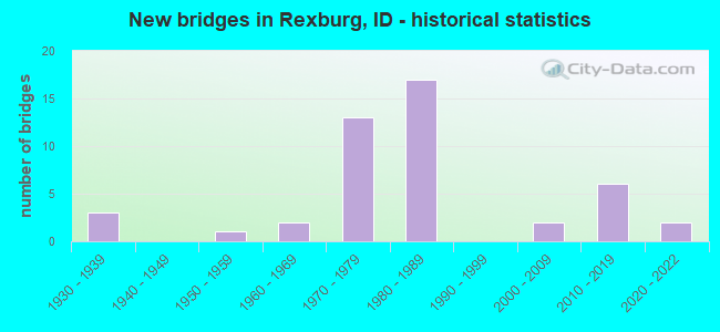
- New bridges - historical statistics
- 31930-1939
- 11950-1959
- 21960-1969
- 131970-1979
- 171980-1989
- 22000-2009
- 62010-2019
- 22020-2022
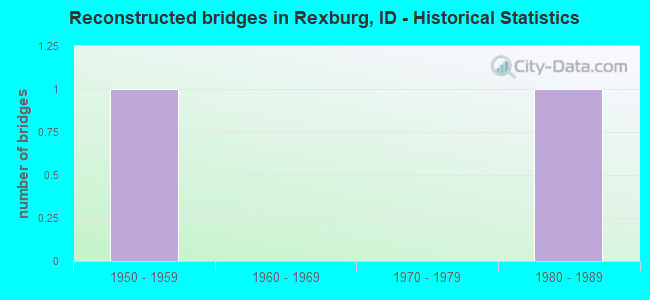
- Reconstructed bridges - Historical Statistics
- 11950-1959
- 01960-1969
- 01970-1979
- 11980-1989
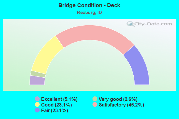
- Bridge Condition - Deck
- 5.1%Excellent
- 2.6%Very good
- 23.1%Good
- 46.2%Satisfactory
- 23.1%Fair
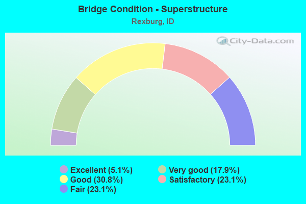
- Bridge Condition - Superstructure
- 5.1%Excellent
- 17.9%Very good
- 30.8%Good
- 23.1%Satisfactory
- 23.1%Fair
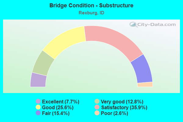
- Bridge Condition - Substructure
- 7.7%Excellent
- 12.8%Very good
- 25.6%Good
- 35.9%Satisfactory
- 15.4%Fair
- 2.6%Poor
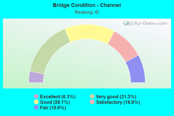
- Bridge Condition - Channel
- 6.3%Excellent
- 31.3%Very good
- 28.1%Good
- 18.8%Satisfactory
- 15.6%Fair
Find on map >> Show street view
Structure Number: 1253, Location: 1.5 S. REXBURG (Lat: 43.804289, Lng: -111.813183), Route carried "under" structure: County highway 7726, Year Built: 1981, Structure Length: 0. m, Average Daily Traffic: 10,500 (year 2018), Truck Traffic: 4%, Features Intersected: STP 7726;S.REXBURG IC, Facility Carried by Structure: US 20 EBL
Minimum Vertical Clearance: 5.23m (17.16ft), Kilometerpoint: 16.488, Lanes on structure: 2, Lanes under structure: 4, Material/Design: Prestressed concrete continuous, Design/Construction: Box Beam or Girders - Single/Spread, Length of Maximum Span: 29.9m (98.1ft)
Find on map >> Show street view
Structure Number: 12535, Location: 1.5 S. REXBURG (Lat: 43.804736, Lng: -111.813447), Route carried "under" structure: County highway 7726, Year Built: 1981, Structure Length: 0. m, Average Daily Traffic: 10,500 (year 2018), Truck Traffic: 4%, Features Intersected: STP 7726;S.REXBURG IC, Facility Carried by Structure: US 20 WBL
Minimum Vertical Clearance: 5.33m (17.49ft), Kilometerpoint: 16.507, Lanes on structure: 2, Lanes under structure: 4, Material/Design: Prestressed concrete, Design/Construction: Box Beam or Girders - Single/Spread, Length of Maximum Span: 29.9m (98.1ft)
Find on map >> Show street view
Structure Number: 1255, Location: 0.5 W. REXBURG;SH 33 (Lat: 43.825856, Lng: -111.811017), Route carried "under" structure: State highway 33, Year Built: 1981, Structure Length: 0. m, Average Daily Traffic: 15,000 (year 2018), Truck Traffic: 4%, Features Intersected: SH 33;REXBURG IC, Facility Carried by Structure: US 20 EBL
Minimum Vertical Clearance: 5.39m (17.68ft), Kilometerpoint: 125.819, Lanes on structure: 2, Lanes under structure: 5, Material/Design: Prestressed concrete continuous, Design/Construction: Box Beam or Girders - Single/Spread, Length of Maximum Span: 29.9m (98.1ft)
Find on map >> Show street view
Structure Number: 12555, Location: 0.5 W. REXBURG;SH 33 (Lat: 43.826328, Lng: -111.811414), Route carried "under" structure: State highway 33, Year Built: 1981, Structure Length: 0. m, Average Daily Traffic: 15,000 (year 2018), Truck Traffic: 4%, Features Intersected: SH 33;REXBURG IC, Facility Carried by Structure: US 20 WBL
Minimum Vertical Clearance: 5.28m (17.32ft), Kilometerpoint: 125.851, Lanes on structure: 2, Lanes under structure: 5, Material/Design: Prestressed concrete, Design/Construction: Box Beam or Girders - Single/Spread, Length of Maximum Span: 29.9m (98.1ft)
Find on map >> Show street view
Structure Number: 2098, Location: 2.0 N. REXBURG (Lat: 43.863417, Lng: -111.777806), Route carried "under" structure: US 20, Year Built: 1982, Structure Length: 0. m, Average Daily Traffic: 13,500 (year 2018), Truck Traffic: 9%, Features Intersected: US 20;SALEM RD IC, Facility Carried by Structure: STP 7786;SALEM RD
Minimum Vertical Clearance: 5.18m (16.99ft), Kilometerpoint: 542.108, Lanes on structure: 2, Lanes under structure: 4, Material/Design: Steel continuous, Design/Construction: Stringer/Multi-beam, Length of Maximum Span: 40.2m (131.9ft)
Find on map >> Show street view
Structure Number: 3469, Location: AT THORTON (Lat: 43.761972, Lng: -111.844306), Route carried "under" structure: County highway , Year Built: 2016, Structure Length: 0. m, Average Daily Traffic: 2,500 (year 2018), Truck Traffic: 10%, Features Intersected: THORTON IC, Facility Carried by Structure: US 20 EBL
Minimum Vertical Clearance: 5.52m (18.11ft), Kilometerpoint: 158.575, Lanes on structure: 2, Lanes under structure: 2, Material/Design: Prestressed concrete, Design/Construction: Stringer/Multi-beam, Length of Maximum Span: 29.3m (96.1ft)
Find on map >> Show street view
Structure Number: 34695, Location: AT THORTON (Lat: 43.762250, Lng: -111.844583), Route carried "under" structure: County highway , Year Built: 2016, Structure Length: 0. m, Average Daily Traffic: 2,500 (year 2018), Truck Traffic: 11%, Features Intersected: THORTON IC, Facility Carried by Structure: US 20 WBL
Minimum Vertical Clearance: 5.70m (18.70ft), Kilometerpoint: 158.536, Lanes on structure: 2, Lanes under structure: 2, Material/Design: Prestressed concrete, Design/Construction: Stringer/Multi-beam, Length of Maximum Span: 29.3m (96.1ft)