Bridge Statistics for Rensselaer, New York (NY)
Condition, Traffic, Stress, Structural Evaluation, Project Costs
- National Bridge Inventory (NBI) Statistics
- 31Number of bridges
- 653ft / 199mTotal length
- $126,750,000Total costs
- 246,611Total average daily traffic
- 14,057Total average daily truck traffic
- National Bridge Inventory (NBI) Registered Bridges for Rensselaer
- No street view available for this location
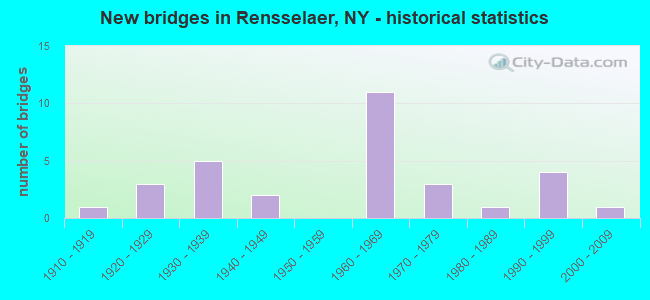
- New bridges - historical statistics
- 11910-1919
- 31920-1929
- 51930-1939
- 21940-1949
- 111960-1969
- 31970-1979
- 11980-1989
- 41990-1999
- 12000-2009

- Reconstructed bridges - Historical Statistics
- 21980-1989
- 01990-1999
- 32000-2009
- 32010-2019


- Bridge Condition - Deck
- 25.0%Very good
- 30.0%Good
- 25.0%Satisfactory
- 15.0%Fair
- 5.0%Poor

- Bridge Condition - Superstructure
- 5.0%Excellent
- 20.0%Very good
- 25.0%Good
- 35.0%Satisfactory
- 10.0%Fair
- 5.0%Serious

- Bridge Condition - Substructure
- 15.0%Very good
- 60.0%Satisfactory
- 20.0%Fair
- 5.0%Imminent failure

- Bridge Condition - Channel
- 25.0%Very good
- 25.0%Good
- 33.3%Satisfactory
- 8.3%Fair
- 8.3%Poor
Find on map >> Show street view
Structure Number: 100552, Location: JCT OF US 9 & 20 / SH 9J (Lat: 42.629247, Lng: -73.743208), Route carried "on" structure: US 9, Year Built: 1930, Year Reconstructed: 2019, Status: Open, Structure Length: 9.45m (31.00ft), Average Daily Traffic: 14,107 (year 2020), Truck Traffic: 5%, Average Future Daily Traffic: 14,173 (year 2040), Features Intersected: RTE 9J, AMTRAK POST ROAD
Minimum Vertical Clearance: 30+ m (98+ ft), Kilometerpoint: 19.710, Lanes on structure: 4, Lanes under structure: 2, Base Highway Network: Yes, Owner: State Highway Agency, Approaching Roadway Width: 14.6m (47.9ft), Material/Design: Steel continuous, Design/Construction: Girder and Floorbeam System, Number Of Spans In Main Unit: 3, Length of Maximum Span: 36.5m (119.8ft), Curb or Sidewalk Widths: Left: 1.5m (4.9ft), Right: 1.5m (4.9ft), Curb-To-Curb Width: 12.8m (42.0ft), Out-to-Out Width: 14.2m (46.6ft)
Condition: Deck: Very good, Superstructure: Satisfactory, Substructure: Satisfactory, Operating Rating: 42.6 metric tons, Method Used To Determine Operating Rating: Load Factor (LF), Inventory Rating: 25.4 metric tons, Method Used To Determine Inventory Rating: Load Factor (LF), Structural Evaluation: Equal to present minimum criteria, Deck Geometry: High priority of replacement, Underclear: High priority of corrective action, Approach Roadway Alignment: Equal to present desirable criteria, Length Of Structure Improvement: 9.44m (30.97ft), Designated Inspection Frequency: Every 24 months, Critical Feature Inspection Frequency: Every 24 months, Inspection Date: September 2021, Critical Feature Inspection Date: September 2021, Bridge Improvement Cost: $3,414,000, Roadway Improvement Cost: $1,999,000, Total Project Cost: $5,413,000 ( Estimate for 2021), Deck Structure Type: Concrete Cast-file-Place, Wearing Surface/Protective System: Wearing Surface: Integral Concrete, Deck Protection: Epoxy Coated Reinforcing
Find on map >> Show street view
Structure Number: 10926, Location: 1 MILE N JCT SH 43 & I90 (Lat: 42.659933, Lng: -73.722078), Route carried "on" structure: City street , Year Built: 1968, Year Reconstructed: 2012, Status: Open, Structure Length: 6.10m (20.01ft), Average Daily Traffic: 4,846 (year 2020), Truck Traffic: 3%, Average Future Daily Traffic: 5,886 (year 2040), Design Load: HS 20, Features Intersected: 90I 90I14021005 WB, RTE, Facility Carried by Structure: WASHINGTON AVENUE
Minimum Vertical Clearance: 30+ m (98+ ft), Kilometerpoint: 2.092, Lanes on structure: 2, Lanes under structure: 6, Owner: State Highway Agency, Approaching Roadway Width: 9.1m (29.9ft), Skew: 2 degrees, Material/Design: Steel, Design/Construction: Stringer/Multi-beam, Number Of Spans In Main Unit: 2, Length of Maximum Span: 29.5m (96.8ft), Curb or Sidewalk Widths: Left: 1.7m (5.6ft), Right: 1.1m (3.6ft), Curb-To-Curb Width: 9.1m (29.9ft), Out-to-Out Width: 13.0m (42.7ft)
Condition: Deck: Very good, Superstructure: Good, Substructure: Satisfactory, Operating Rating: 67.1 metric tons, Method Used To Determine Operating Rating: Load and Resistance Factor Rating (LRFR) rating reported by rating factor(RF) method using HL-93 loadings, Inventory Rating: 51.5 metric tons, Method Used To Determine Inventory Rating: Load and Resistance Factor Rating (LRFR) rating reported by rating factor(RF) method using HL-93 loadings, Structural Evaluation: Equal to present minimum criteria, Deck Geometry: Meets minimum limits, Underclear: High priority of corrective action, Approach Roadway Alignment: Equal to present desirable criteria, Length Of Structure Improvement: 6.09m (19.98ft), Designated Inspection Frequency: Every 24 months, Inspection Date: September 2021, Bridge Improvement Cost: $1,953,000, Roadway Improvement Cost: $1,144,000, Total Project Cost: $3,096,000 ( Estimate for 2021), Deck Structure Type: Concrete Cast-file-Place, Wearing Surface/Protective System: Wearing Surface: Integral Concrete, Deck Protection: Epoxy Coated Reinforcing
Find on map >> Show street view
Structure Number: 1092621, Location: JCT OF RTS 43 & I90 (Lat: 42.644144, Lng: -73.710356), Route carried "on" structure: Interstate 90, Year Built: 1968, Status: Open, Structure Length: 2.80m (9.19ft), Average Daily Traffic: 23,104 (year 2015), Truck Traffic: 9%, Design Load: HS 20, Features Intersected: RTE 43
Minimum Vertical Clearance: 30+ m (98+ ft), Kilometerpoint: 13.274, Lanes on structure: 3, Lanes under structure: 2, Base Highway Network: Yes, Owner: State Highway Agency, Approaching Roadway Width: 15.5m (50.9ft), Skew: 1 degrees, Material/Design: Steel, Design/Construction: Stringer/Multi-beam, Number Of Spans In Main Unit: 1, Length of Maximum Span: 26.5m (86.9ft), Curb-To-Curb Width: 15.8m (51.8ft), Out-to-Out Width: 16.6m (54.5ft)
Condition: Deck: Satisfactory, Superstructure: Satisfactory, Substructure: Satisfactory, Operating Rating: 77.1 metric tons, Method Used To Determine Operating Rating: Load and Resistance Factor Rating (LRFR) rating reported by rating factor(RF) method using HL-93 loadings, Inventory Rating: 59.3 metric tons, Method Used To Determine Inventory Rating: Load and Resistance Factor Rating (LRFR) rating reported by rating factor(RF) method using HL-93 loadings, Structural Evaluation: Equal to present minimum criteria, Deck Geometry: Somewhat better than minimum adequacy, Underclear: Meets minimum limits, Approach Roadway Alignment: Equal to present desirable criteria, Length Of Structure Improvement: 2.80m (9.19ft), Designated Inspection Frequency: Every 24 months, Inspection Date: March 2020, Bridge Improvement Cost: $1,406,000, Roadway Improvement Cost: $823,000, Total Project Cost: $2,229,000 ( Estimate for 2021), Deck Structure Type: Concrete Cast-file-Place, Wearing Surface/Protective System: Wearing Surface: Monolithic Concrete
Find on map >> Show street view
Structure Number: 1092622, Location: JCT OF RTS 43 & I90 (Lat: 42.644167, Lng: -73.710739), Route carried "on" structure: Interstate 90, Year Built: 1968, Status: Open, Structure Length: 2.80m (9.19ft), Average Daily Traffic: 17,702 (year 2019), Truck Traffic: 9%, Average Future Daily Traffic: 28,052 (year 2040), Design Load: HS 20, Features Intersected: RTE 43
Minimum Vertical Clearance: 30+ m (98+ ft), Kilometerpoint: 2.816, Lanes on structure: 3, Lanes under structure: 2, Base Highway Network: Yes, Owner: State Highway Agency, Approaching Roadway Width: 15.5m (50.9ft), Skew: 1 degrees, Material/Design: Steel, Design/Construction: Stringer/Multi-beam, Number Of Spans In Main Unit: 1, Length of Maximum Span: 26.5m (86.9ft), Curb-To-Curb Width: 15.8m (51.8ft), Out-to-Out Width: 16.6m (54.5ft)
Condition: Deck: Satisfactory, Superstructure: Satisfactory, Substructure: Fair, Operating Rating: 78.4 metric tons, Method Used To Determine Operating Rating: Load and Resistance Factor Rating (LRFR) rating reported by rating factor(RF) method using HL-93 loadings, Inventory Rating: 60.3 metric tons, Method Used To Determine Inventory Rating: Load and Resistance Factor Rating (LRFR) rating reported by rating factor(RF) method using HL-93 loadings, Structural Evaluation: Somewhat better than minimum adequacy, Deck Geometry: Somewhat better than minimum adequacy, Underclear: Somewhat better than minimum adequacy, Approach Roadway Alignment: Equal to present desirable criteria, Length Of Structure Improvement: 2.80m (9.19ft), Designated Inspection Frequency: Every 24 months, Inspection Date: March 2020, Bridge Improvement Cost: $1,406,000, Roadway Improvement Cost: $823,000, Total Project Cost: $2,229,000 ( Estimate for 2021), Deck Structure Type: Concrete Cast-file-Place, Wearing Surface/Protective System: Wearing Surface: Monolithic Concrete
Find on map >> Show street view
Structure Number: 1093029, Location: DOWNTOWN ALBANY (Lat: 42.642697, Lng: -73.746464), Route carried "on" structure: US 9, Year Built: 1969, Year Reconstructed: 2012, Status: Open, Structure Length: 30.02m (98.49ft), Average Daily Traffic: 26,587 (year 2007), Truck Traffic: 6%, Average Future Daily Traffic: 26,711 (year 2040), Design Load: HS 20+Mod, Features Intersected: HUDSON RIVER
Minimum Vertical Clearance: 5.66m (18.57ft), Kilometerpoint: 0.129, Lanes on structure: 8, Base Highway Network: Yes, Owner: State Highway Agency, Approaching Roadway Width: 31.7m (104.0ft), Skew: 20 degrees, Navigation Control: Yes ( Vertical Clearance: 18.2m (59.7ft), Horizontal Clearance: 91.4m (299.9ft)), Material/Design: Steel continuous, Design/Construction: Stringer/Multi-beam, Number Of Spans In Main Unit: 6, Length of Maximum Span: 106.7m (350.1ft), Curb or Sidewalk Widths: Left: 2.0m (6.6ft), Right: 0.6m (2.0ft), Curb-To-Curb Width: 31.7m (104.0ft), Out-to-Out Width: 36.7m (120.4ft)
Condition: Deck: Good, Superstructure: Satisfactory, Substructure: Fair, Channel: Good, Operating Rating: 49.6 metric tons, Method Used To Determine Operating Rating: Load and Resistance Factor Rating (LRFR) rating reported by rating factor(RF) method using HL-93 loadings, Inventory Rating: 38.2 metric tons, Method Used To Determine Inventory Rating: Load and Resistance Factor Rating (LRFR) rating reported by rating factor(RF) method using HL-93 loadings, Structural Evaluation: Somewhat better than minimum adequacy, Deck Geometry: Somewhat better than minimum adequacy, Waterway Adequacy: Equal to present minimum criteria, Approach Roadway Alignment: Equal to present desirable criteria, Length Of Structure Improvement: 30.02m (98.49ft), Designated Inspection Frequency: Every 24 months, Critical Feature Inspection Frequency: Every 12 months, Underwater Inspection Frequency: Every 60 months, Inspection Date: November 2021, Critical Feature Inspection Date: November 2021, Underwater Inspection Date: October 2017, Bridge Improvement Cost: $27,756,000, Roadway Improvement Cost: $16,254,000, Total Project Cost: $44,010,000 ( Estimate for 2021), Deck Structure Type: Concrete Cast-file-Place, Wearing Surface/Protective System: Wearing Surface: Latex Concrete
Find on map >> Show street view
Structure Number: 109302A, Location: RAMP RT 9 NB TO DUNN BR (Lat: 42.641850, Lng: -73.744269), Route carried "on" structure: Ramp US 9, Year Built: 1969, Status: Open, Structure Length: 46.21m (151.61ft), Average Daily Traffic: 26,587 (year 2007), Truck Traffic: 6%, Average Future Daily Traffic: 26,711 (year 2040), Design Load: HS 20, Features Intersected: RAMP- DUNN TO BROADWAY,
Minimum Vertical Clearance: 30+ m (98+ ft), Kilometerpoint: 21.174, Lanes on structure: 2, Lanes under structure: 4, Base Highway Network: Yes, Owner: State Highway Agency, Approaching Roadway Width: 7.9m (25.9ft), Material/Design: Steel continuous, Design/Construction: Stringer/Multi-beam, Number Of Spans In Main Unit: 15, Length of Maximum Span: 35.4m (116.1ft), Curb or Sidewalk Widths: Left: 0.6m (2.0ft), Right: 2.4m (7.9ft), Curb-To-Curb Width: 7.9m (25.9ft), Out-to-Out Width: 12.0m (39.4ft)
Condition: Deck: Good, Superstructure: Good, Substructure: Satisfactory, Channel: Very good, Operating Rating: 90.0 metric tons, Method Used To Determine Operating Rating: Field evaluation and documented engineering judgment, Inventory Rating: 32.7 metric tons, Method Used To Determine Inventory Rating: Field evaluation and documented engineering judgment, Structural Evaluation: Equal to present minimum criteria, Deck Geometry: High priority of replacement, Underclear: High priority of corrective action, Waterway Adequacy: Equal to present minimum criteria, Approach Roadway Alignment: Equal to present desirable criteria, Length Of Structure Improvement: 46.20m (151.57ft), Designated Inspection Frequency: Every 24 months, Inspection Date: October 2021, Bridge Improvement Cost: $11,596,000, Roadway Improvement Cost: $6,791,000, Total Project Cost: $18,387,000 ( Estimate for 2021), Deck Structure Type: Concrete Cast-file-Place, Wearing Surface/Protective System: Wearing Surface: Integral Concrete
Find on map >> Show street view
Structure Number: 109302B, Location: RT 9 SB OFF DUNN BR (Lat: 42.642092, Lng: -73.745306), Route carried "on" structure: Ramp US 9, Year Built: 1969, Status: Open, Structure Length: 24.05m (78.90ft), Average Daily Traffic: 26,587 (year 2007), Truck Traffic: 6%, Average Future Daily Traffic: 26,711 (year 2040), Design Load: HS 20, Features Intersected: RAMP- DUNN TO BROADWAY,
Minimum Vertical Clearance: 32.69m (107.25ft), Kilometerpoint: 0.129, Lanes on structure: 2, Lanes under structure: 2, Base Highway Network: Yes, Owner: State Highway Agency, Approaching Roadway Width: 8.8m (28.9ft), Material/Design: Steel continuous, Design/Construction: Stringer/Multi-beam, Number Of Spans In Main Unit: 8, Length of Maximum Span: 35.9m (117.8ft), Curb or Sidewalk Widths: Left: 0.5m (1.6ft), Right: 0.6m (2.0ft), Curb-To-Curb Width: 8.9m (29.2ft), Out-to-Out Width: 11.5m (37.7ft)
Condition: Deck: Satisfactory, Superstructure: Satisfactory, Substructure: Fair, Channel: Very good, Operating Rating: 53.5 metric tons, Method Used To Determine Operating Rating: Load Factor (LF), Inventory Rating: 31.8 metric tons, Method Used To Determine Inventory Rating: Load Factor (LF), Structural Evaluation: Somewhat better than minimum adequacy, Deck Geometry: Meets minimum limits, Underclear: High priority of corrective action, Waterway Adequacy: Equal to present minimum criteria, Approach Roadway Alignment: Equal to present desirable criteria, Length Of Structure Improvement: 24.04m (78.87ft), Designated Inspection Frequency: Every 24 months, Inspection Date: October 2021, Bridge Improvement Cost: $6,200,000, Roadway Improvement Cost: $3,631,000, Total Project Cost: $9,831,000 ( Estimate for 2021), Deck Structure Type: Concrete Cast-file-Place, Wearing Surface/Protective System: Wearing Surface: Integral Concrete
Find on map >> Show street view
Structure Number: 109306, Location: JCT RTS 9 & 20 & HUDSON R (Lat: 42.641333, Lng: -73.747039), Route carried "on" structure: Ramp US , Year Built: 1971, Status: Open, Structure Length: 2.80m (9.19ft), Average Daily Traffic: 5,163 (year 2018), Truck Traffic: 6%, Average Future Daily Traffic: 5,187 (year 2040), Design Load: HS 20, Features Intersected: PEDESTRIAN PATH, MILL CR, Facility Carried by Structure: DUNN RAMP TO BDWY
Minimum Vertical Clearance: 30+ m (98+ ft), Kilometerpoint: 0.097, Lanes on structure: 2, Owner: State Highway Agency, Approaching Roadway Width: 7.3m (24.0ft), Material/Design: Steel, Design/Construction: Stringer/Multi-beam, Number Of Spans In Main Unit: 1, Length of Maximum Span: 26.8m (87.9ft), Curb or Sidewalk Widths: Left: 0.6m (2.0ft), Right: 0.6m (2.0ft), Curb-To-Curb Width: 7.3m (24.0ft), Out-to-Out Width: 9.3m (30.5ft)
Condition: Deck: Satisfactory, Superstructure: Very good, Substructure: Satisfactory, Channel: Good, Operating Rating: 49.9 metric tons, Method Used To Determine Operating Rating: Load Factor (LF), Inventory Rating: 29.9 metric tons, Method Used To Determine Inventory Rating: Load Factor (LF), Structural Evaluation: Equal to present minimum criteria, Deck Geometry: High priority of replacement, Waterway Adequacy: Equal to present minimum criteria, Approach Roadway Alignment: Equal to present desirable criteria, Length Of Structure Improvement: 2.80m (9.19ft), Designated Inspection Frequency: Every 24 months, Inspection Date: June 2021, Bridge Improvement Cost: $941,000, Roadway Improvement Cost: $551,000, Total Project Cost: $1,492,000 ( Estimate for 2021), Deck Structure Type: Concrete Cast-file-Place, Wearing Surface/Protective System: Wearing Surface: Integral Concrete
Find on map >> Show street view
Structure Number: 200551, Location: JCT US 9 & 20 / SH 9J (Lat: 42.630822, Lng: -73.744169), Route carried "on" structure: US 9, Year Built: 1935, Year Reconstructed: 2019, Status: Open, Structure Length: 6.19m (20.31ft), Average Daily Traffic: 20,033 (year 2017), Truck Traffic: 6%, Average Future Daily Traffic: 20,127 (year 2040), Design Load: HS 20, Features Intersected: CSX TRANS/ AMTRAK
Minimum Vertical Clearance: 30+ m (98+ ft), Kilometerpoint: 19.936, Lanes on structure: 4, Base Highway Network: Yes, Owner: State Highway Agency, Approaching Roadway Width: 12.8m (42.0ft), Material/Design: Steel continuous, Design/Construction: Girder and Floorbeam System, Number Of Spans In Main Unit: 2, Length of Maximum Span: 29.5m (96.8ft), Curb or Sidewalk Widths: Left: 1.5m (4.9ft), Right: 1.5m (4.9ft), Curb-To-Curb Width: 12.8m (42.0ft), Out-to-Out Width: 14.2m (46.6ft)
Condition: Deck: Very good, Superstructure: Fair, Substructure: Satisfactory, Operating Rating: 49.0 metric tons, Method Used To Determine Operating Rating: Load Factor (LF), Inventory Rating: 29.0 metric tons, Method Used To Determine Inventory Rating: Load Factor (LF), Structural Evaluation: Somewhat better than minimum adequacy, Deck Geometry: High priority of replacement, Underclear: Somewhat better than minimum adequacy, Approach Roadway Alignment: Equal to present desirable criteria, Length Of Structure Improvement: 6.18m (20.28ft), Designated Inspection Frequency: Every 24 months, Critical Feature Inspection Frequency: Every 24 months, Inspection Date: December 2021, Critical Feature Inspection Date: December 2021, Bridge Improvement Cost: $3,840,000, Roadway Improvement Cost: $2,248,000, Total Project Cost: $6,088,000 ( Estimate for 2021), Deck Structure Type: Concrete Cast-file-Place, Wearing Surface/Protective System: Wearing Surface: Integral Concrete, Deck Protection: Epoxy Coated Reinforcing
Find on map >> Show street view
Structure Number: 202533, Location: .5 MI E JCT US 9 & US 20 (Lat: 42.637203, Lng: -73.741258), Route carried "on" structure: City street 151, Year Built: 1929, Year Reconstructed: 2017, Status: Open, Structure Length: 21.46m (70.41ft), Average Daily Traffic: 6,131 (year 2020), Truck Traffic: 2%, Average Future Daily Traffic: 7,447 (year 2040), Design Load: HS 20, Features Intersected: EAST STREET, MILL CREEK,
Minimum Vertical Clearance: 30+ m (98+ ft), Kilometerpoint: 0.322, Lanes on structure: 2, Lanes under structure: 2, Base Highway Network: Yes, Owner: City or Municipal Highway Agency, Approaching Roadway Width: 9.1m (29.9ft), Material/Design: Steel continuous, Design/Construction: Girder and Floorbeam System, Number Of Spans In Main Unit: 8, Number Of Approach Spans: 1, Length of Maximum Span: 27.7m (90.9ft), Curb or Sidewalk Widths: Left: 0.0m, Right: 1.6m (5.2ft), Curb-To-Curb Width: 8.5m (27.9ft), Out-to-Out Width: 10.2m (33.5ft)
Condition: Deck: Good, Superstructure: Satisfactory, Substructure: Satisfactory, Channel: Very good, Operating Rating: 61.7 metric tons, Method Used To Determine Operating Rating: Load Factor (LF), Inventory Rating: 36.3 metric tons, Method Used To Determine Inventory Rating: Load Factor (LF), Structural Evaluation: Equal to present minimum criteria, Deck Geometry: Meets minimum limits, Underclear: Meets minimum limits, Waterway Adequacy: Equal to present minimum criteria, Approach Roadway Alignment: Meets minimum limits, Length Of Structure Improvement: 21.45m (70.37ft), Designated Inspection Frequency: Every 24 months, Critical Feature Inspection Frequency: Every 24 months, Inspection Date: September 2021, Critical Feature Inspection Date: September 2021, Bridge Improvement Cost: $4,455,000, Roadway Improvement Cost: $2,609,000, Total Project Cost: $7,064,000 ( Estimate for 2021), Deck Structure Type: Concrete Cast-file-Place, Wearing Surface/Protective System: Wearing Surface: Integral Concrete, Deck Protection: Epoxy Coated Reinforcing
Find on map >> Show street view
Structure Number: 220219, Location: BROADWAY CITY RENSSELAER (Lat: 42.640658, Lng: -73.745164), Route carried "on" structure: City street , Year Built: 1940, Year Reconstructed: 1987, Status: Open, Structure Length: 0.82m (2.69ft), Average Daily Traffic: 7,273 (year 2019), Truck Traffic: 3%, Average Future Daily Traffic: 8,835 (year 2040), Design Load: HS 20, Features Intersected: MILL CREEK, Facility Carried by Structure: BROADWAY
Minimum Vertical Clearance: 30+ m (98+ ft), Kilometerpoint: 0.660, Lanes on structure: 2, Owner: City or Municipal Highway Agency, Approaching Roadway Width: 13.4m (44.0ft), Material/Design: Prestressed concrete, Design/Construction: Box Beam or Girders - Multiple, Number Of Spans In Main Unit: 1, Length of Maximum Span: 7.3m (24.0ft), Curb or Sidewalk Widths: Left: 1.9m (6.2ft), Right: 4.2m (13.8ft), Curb-To-Curb Width: 12.3m (40.4ft), Out-to-Out Width: 20.2m (66.3ft)
Condition: Deck: Good, Superstructure: Excellent, Substructure: Fair, Channel: Satisfactory, Inventory Rating: 29.9 metric tons, Method Used To Determine Inventory Rating: Load Factor (LF), Structural Evaluation: Somewhat better than minimum adequacy, Deck Geometry: Somewhat better than minimum adequacy, Waterway Adequacy: Meets minimum limits, Approach Roadway Alignment: Somewhat better than minimum adequacy, Length Of Structure Improvement: 0.82m (2.69ft), Designated Inspection Frequency: Every 24 months, Inspection Date: August 2020, Bridge Improvement Cost: $1,127,000, Roadway Improvement Cost: $660,000, Total Project Cost: $1,787,000 ( Estimate for 2021), Deck Structure Type: Concrete Cast-file-Place, Wearing Surface/Protective System: Wearing Surface: Monolithic Concrete
Find on map >> Show street view
Structure Number: 22022, Location: CITY OF RENSSELAER S.ST. (Lat: 42.635358, Lng: -73.742558), Route carried "on" structure: City street , Year Built: 1929, Status: Open, Structure Length: 1.04m (3.41ft), Average Daily Traffic: 1,147 (year 2018), Truck Traffic: 4%, Average Future Daily Traffic: 1,606 (year 2038), Features Intersected: MILL CREEK, Facility Carried by Structure: SOUTH STREET
Minimum Vertical Clearance: 30+ m (98+ ft), Kilometerpoint: 0.579, Lanes on structure: 2, Owner: City or Municipal Highway Agency, Approaching Roadway Width: 6.7m (22.0ft), Material/Design: Concrete, Design/Construction: Slab, Number Of Spans In Main Unit: 1, Length of Maximum Span: 10.0m (32.8ft), Curb or Sidewalk Widths: Left: 0.0m, Right: 1.5m (4.9ft), Curb-To-Curb Width: 6.2m (20.3ft), Out-to-Out Width: 8.4m (27.6ft)
Condition: Deck: Fair, Superstructure: Fair, Substructure: Satisfactory, Channel: Satisfactory, Operating Rating: 45.6 metric tons, Method Used To Determine Operating Rating: Field evaluation and documented engineering judgment, Inventory Rating: 18.5 metric tons, Method Used To Determine Inventory Rating: Field evaluation and documented engineering judgment, Structural Evaluation: Somewhat better than minimum adequacy, Deck Geometry: High priority of replacement, Waterway Adequacy: Meets minimum limits, Approach Roadway Alignment: Somewhat better than minimum adequacy, Length Of Structure Improvement: 1.03m (3.38ft), Designated Inspection Frequency: Every 24 months, Inspection Date: April 2020, Bridge Improvement Cost: $440,000, Roadway Improvement Cost: $257,000, Total Project Cost: $697,000 ( Estimate for 2021), Wearing Surface/Protective System: Wearing Surface: Bituminous
Find on map >> Show street view
Structure Number: 220222, Location: CITY OF RENSSELAER (Lat: 42.644864, Lng: -73.741117), Route carried "on" structure: City street , Year Built: 1975, Year Reconstructed: 2012, Status: Open, Structure Length: 20.79m (68.21ft), Average Daily Traffic: 3,514 (year 2019), Truck Traffic: 6%, Average Future Daily Traffic: 4,268 (year 2040), Design Load: HS 25 or greater, Features Intersected: CSX TRANS/ AMTRAK, AMTRA, Facility Carried by Structure: BROADWAY
Minimum Vertical Clearance: 30+ m (98+ ft), Kilometerpoint: 1.223, Lanes on structure: 2, Lanes under structure: 2, Owner: City or Municipal Highway Agency, Approaching Roadway Width: 8.8m (28.9ft), Skew: 3 degrees, Material/Design: Steel continuous, Design/Construction: Girder and Floorbeam System, Number Of Spans In Main Unit: 8, Length of Maximum Span: 31.3m (102.7ft), Curb or Sidewalk Widths: Left: 1.7m (5.6ft), Right: 1.7m (5.6ft), Curb-To-Curb Width: 8.7m (28.5ft), Out-to-Out Width: 13.4m (44.0ft)
Condition: Deck: Good, Superstructure: Satisfactory, Substructure: Satisfactory, Operating Rating: 67.1 metric tons, Method Used To Determine Operating Rating: Load Factor (LF), Inventory Rating: 39.9 metric tons, Method Used To Determine Inventory Rating: Load Factor (LF), Structural Evaluation: Equal to present minimum criteria, Deck Geometry: Meets minimum limits, Underclear: High priority of corrective action, Approach Roadway Alignment: Equal to present desirable criteria, Length Of Structure Improvement: 20.78m (68.18ft), Designated Inspection Frequency: Every 24 months, Critical Feature Inspection Frequency: Every 24 months, Inspection Date: September 2021, Critical Feature Inspection Date: September 2021, Bridge Improvement Cost: $6,073,000, Roadway Improvement Cost: $3,556,000, Total Project Cost: $9,629,000 ( Estimate for 2021), Deck Structure Type: Concrete Cast-file-Place, Wearing Surface/Protective System: Wearing Surface: Integral Concrete, Deck Protection: Epoxy Coated Reinforcing
Find on map >> Show street view
Structure Number: 220223, Location: CITY OF RENSSELAER (Lat: 42.642003, Lng: -73.741594), Route carried "on" structure: City street , Year Built: 2001, Status: Open, Structure Length: 7.89m (25.89ft), Average Daily Traffic: 2,870 (year 2019), Truck Traffic: 5%, Average Future Daily Traffic: 3,551 (year 2040), Design Load: HS 25 or greater, Features Intersected: AMTRAK-2, AMTRAK-3, CSX, Facility Carried by Structure: HERRICK ST
Minimum Vertical Clearance: 30+ m (98+ ft), Kilometerpoint: 0.032, Lanes on structure: 2, Owner: State Agenciy, Approaching Roadway Width: 8.5m (27.9ft), Material/Design: Prestressed concrete continuous, Design/Construction: Box Beam or Girders - Multiple, Number Of Spans In Main Unit: 4, Length of Maximum Span: 20.8m (68.2ft), Curb or Sidewalk Widths: Left: 1.5m (4.9ft), Right: 1.5m (4.9ft), Curb-To-Curb Width: 8.5m (27.9ft), Out-to-Out Width: 12.6m (41.3ft)
Condition: Deck: Good, Superstructure: Good, Substructure: Very good, Operating Rating: 92.5 metric tons, Method Used To Determine Operating Rating: Load Factor (LF), Inventory Rating: 55.3 metric tons, Method Used To Determine Inventory Rating: Load Factor (LF), Structural Evaluation: Better than present minimum criteria, Deck Geometry: Meets minimum limits, Underclear: High priority of corrective action, Approach Roadway Alignment: Equal to present desirable criteria, Length Of Structure Improvement: 7.89m (25.89ft), Designated Inspection Frequency: Every 24 months, Inspection Date: November 2020, Bridge Improvement Cost: $3,471,000, Roadway Improvement Cost: $2,033,000, Total Project Cost: $5,504,000 ( Estimate for 2021), Deck Structure Type: Concrete Cast-file-Place, Wearing Surface/Protective System: Wearing Surface: Integral Concrete, Deck Protection: Epoxy Coated Reinforcing
Find on map >> Show street view
Structure Number: 220224, Location: CITY OF RENSS -HIGH ST (Lat: 42.634100, Lng: -73.736461), Route carried "on" structure: City street , Year Built: 1997, Status: Open, Structure Length: 2.04m (6.69ft), Average Daily Traffic: 1,097 (year 2020), Truck Traffic: 2%, Average Future Daily Traffic: 1,536 (year 2040), Design Load: HS 25 or greater, Features Intersected: MILL CREEK, Facility Carried by Structure: HIGH STREET
Minimum Vertical Clearance: 30+ m (98+ ft), Kilometerpoint: 0.322, Lanes on structure: 2, Owner: City or Municipal Highway Agency, Approaching Roadway Width: 9.1m (29.9ft), Material/Design: Prestressed concrete, Design/Construction: Box Beam or Girders - Multiple, Number Of Spans In Main Unit: 1, Length of Maximum Span: 18.8m (61.7ft), Curb-To-Curb Width: 9.4m (30.8ft), Out-to-Out Width: 10.1m (33.1ft)
Condition: Deck: Fair, Superstructure: Good, Substructure: Very good, Channel: Satisfactory, Operating Rating: 89.8 metric tons, Method Used To Determine Operating Rating: Load Factor (LF), Inventory Rating: 47.2 metric tons, Method Used To Determine Inventory Rating: Load Factor (LF), Structural Evaluation: Better than present minimum criteria, Deck Geometry: Somewhat better than minimum adequacy, Waterway Adequacy: Somewhat better than minimum adequacy, Approach Roadway Alignment: Equal to present desirable criteria, Length Of Structure Improvement: 2.04m (6.69ft), Designated Inspection Frequency: Every 24 months, Inspection Date: May 2020, Bridge Improvement Cost: $803,000, Roadway Improvement Cost: $470,000, Total Project Cost: $1,273,000 ( Estimate for 2021), Deck Structure Type: Concrete Cast-file-Place, Wearing Surface/Protective System: Wearing Surface: Monolithic Concrete, Deck Protection: Epoxy Coated Reinforcing
Find on map >> Show street view
Structure Number: 220225, Location: SECOND AVE. RENSSELAER (Lat: 42.634989, Lng: -73.739542), Route carried "on" structure: City street , Year Built: 1986, Status: Open, Structure Length: 1.04m (3.41ft), Average Daily Traffic: 249 (year 2020), Truck Traffic: 5%, Average Future Daily Traffic: 349 (year 2040), Design Load: HS 20, Features Intersected: MILL CREEK, Facility Carried by Structure: SECOND AVENUE
Minimum Vertical Clearance: 30+ m (98+ ft), Kilometerpoint: 0.113, Lanes on structure: 2, Owner: City or Municipal Highway Agency, Approaching Roadway Width: 6.7m (22.0ft), Material/Design: Prestressed concrete, Design/Construction: Box Beam or Girders - Multiple, Number Of Spans In Main Unit: 1, Length of Maximum Span: 9.4m (30.8ft), Curb or Sidewalk Widths: Left: 1.3m (4.3ft), Right: 1.3m (4.3ft), Curb-To-Curb Width: 6.7m (22.0ft), Out-to-Out Width: 10.1m (33.1ft)
Condition: Deck: Satisfactory, Superstructure: Very good, Substructure: Satisfactory, Channel: Satisfactory, Inventory Rating: 62.6 metric tons, Method Used To Determine Inventory Rating: Load Factor (LF), Structural Evaluation: Equal to present minimum criteria, Deck Geometry: Meets minimum limits, Waterway Adequacy: Meets minimum limits, Approach Roadway Alignment: Equal to present desirable criteria, Length Of Structure Improvement: 1.03m (3.38ft), Designated Inspection Frequency: Every 24 months, Inspection Date: July 2020, Bridge Improvement Cost: $495,000, Roadway Improvement Cost: $290,000, Total Project Cost: $785,000 ( Estimate for 2021), Deck Structure Type: Concrete Cast-file-Place, Wearing Surface/Protective System: Wearing Surface: Monolithic Concrete, Deck Protection: Epoxy Coated Reinforcing
Find on map >> Show street view
Structure Number: 220226, Location: CITY OF RENSSELAER,WASH S (Lat: 42.640322, Lng: -73.743942), Route carried "on" structure: City street , Year Built: 1940, Year Reconstructed: 1986, Status: Open, Structure Length: 0.91m (2.99ft), Average Daily Traffic: 5,062 (year 2020), Truck Traffic: 3%, Average Future Daily Traffic: 6,149 (year 2040), Features Intersected: MILL CREEK, Facility Carried by Structure: WASHINGTON ST
Minimum Vertical Clearance: 30+ m (98+ ft), Kilometerpoint: 0.499, Lanes on structure: 2, Owner: City or Municipal Highway Agency, Approaching Roadway Width: 6.1m (20.0ft), Material/Design: Prestressed concrete, Design/Construction: Box Beam or Girders - Multiple, Number Of Spans In Main Unit: 1, Length of Maximum Span: 7.9m (25.9ft), Curb or Sidewalk Widths: Left: 1.4m (4.6ft), Right: 1.4m (4.6ft), Curb-To-Curb Width: 6.1m (20.0ft), Out-to-Out Width: 8.9m (29.2ft)
Condition: Deck: Fair, Superstructure: Good, Substructure: Satisfactory, Channel: Good, Operating Rating: 70.5 metric tons, Method Used To Determine Operating Rating: Field evaluation and documented engineering judgment, Inventory Rating: 30.6 metric tons, Method Used To Determine Inventory Rating: Field evaluation and documented engineering judgment, Structural Evaluation: Equal to present minimum criteria, Deck Geometry: High priority of replacement, Waterway Adequacy: Somewhat better than minimum adequacy, Approach Roadway Alignment: Somewhat better than minimum adequacy, Length Of Structure Improvement: 0.91m (2.99ft), Designated Inspection Frequency: Every 24 months, Inspection Date: August 2020, Bridge Improvement Cost: $412,000, Roadway Improvement Cost: $241,000, Total Project Cost: $653,000 ( Estimate for 2021), Deck Structure Type: Concrete Cast-file-Place, Wearing Surface/Protective System: Wearing Surface: Monolithic Concrete, Deck Protection: Epoxy Coated Reinforcing
Find on map >> Show street view
Structure Number: 220227, Location: LAWRENCE ST-CITY OF RENSS (Lat: 42.643592, Lng: -73.737514), Route carried "on" structure: Business City street , Year Built: 1997, Status: Open, Structure Length: 0.82m (2.69ft), Average Daily Traffic: 345 (year 2020), Truck Traffic: 5%, Average Future Daily Traffic: 483 (year 2040), Design Load: HS 25 or greater, Features Intersected: HOLLOW CREEK, Facility Carried by Structure: LAWRENCE STREET
Minimum Vertical Clearance: 30+ m (98+ ft), Kilometerpoint: 0.499, Lanes on structure: 2, Owner: City or Municipal Highway Agency, Approaching Roadway Width: 8.5m (27.9ft), Skew: 4 degrees, Material/Design: Concrete, Design/Construction: Culvert, Number Of Spans In Main Unit: 1, Length of Maximum Span: 7.6m (24.9ft), Curb-To-Curb Width: 8.5m (27.9ft), Out-to-Out Width: 9.1m (29.9ft)
Condition: Channel: Fair, Culverts: Good, Operating Rating: 83.5 metric tons, Method Used To Determine Operating Rating: Load Factor (LF), Inventory Rating: 51.7 metric tons, Method Used To Determine Inventory Rating: Load Factor (LF), Structural Evaluation: Better than present minimum criteria, Deck Geometry: Equal to present minimum criteria, Waterway Adequacy: Better than present minimum criteria, Approach Roadway Alignment: Equal to present desirable criteria, Length Of Structure Improvement: 0.82m (2.69ft), Designated Inspection Frequency: Every 24 months, Inspection Date: April 2020, Bridge Improvement Cost: $132,000, Roadway Improvement Cost: $78,000, Total Project Cost: $210,000 ( Estimate for 2021), Wearing Surface/Protective System: Wearing Surface: Bituminous, Membrane: Other
Find on map >> Show street view
Structure Number: 220228, Location: CITY OF RENSSELAER (Lat: 42.636517, Lng: -73.743242), Route carried "on" structure: City street , Year Built: 1935, Status: Closed, Structure Length: 1.10m (3.61ft), Average Daily Traffic: 92 (year 2017), Truck Traffic: 5%, Average Future Daily Traffic: 129 (year 2037), Features Intersected: MILL CREEK, Facility Carried by Structure: SECOND AVENUE
Minimum Vertical Clearance: 30+ m (98+ ft), Kilometerpoint: 0.000, Lanes on structure: 2, Owner: City or Municipal Highway Agency, Approaching Roadway Width: 11.3m (37.1ft), Skew: 2 degrees, Material/Design: Steel, Design/Construction: Stringer/Multi-beam, Number Of Spans In Main Unit: 1, Length of Maximum Span: 10.3m (33.8ft), Curb or Sidewalk Widths: Left: 3.4m (11.2ft), Right: 3.0m (9.8ft), Curb-To-Curb Width: 11.3m (37.1ft), Out-to-Out Width: 18.4m (60.4ft)
Condition: Deck: Poor, Superstructure: Serious, Substructure: Imminent failure, Channel: Poor, Deck Geometry: Superior to present desirable criteria, Approach Roadway Alignment: Somewhat better than minimum adequacy, Bridge Posting: Required (Relationship of Operating Rating to Maximum Legal Load: > 39.9% below), Length Of Structure Improvement: 1.09m (3.58ft), Designated Inspection Frequency: Every 12 months, Inspection Date: March 2021, Bridge Improvement Cost: $811,000, Roadway Improvement Cost: $475,000, Total Project Cost: $1,286,000 ( Estimate for 2021), Deck Structure Type: Concrete Cast-file-Place, Wearing Surface/Protective System: Wearing Surface: Bituminous
Find on map >> Show street view
Structure Number: 226778, Location: CITY OF RENSSELAER - PORT (Lat: 42.626011, Lng: -73.745836), Route carried "on" structure: Other road , Year Built: 1990, Status: Open, Structure Length: 3.63m (11.91ft), Average Daily Traffic: 1,758 (year 2019), Truck Traffic: 62%, Average Future Daily Traffic: 2,175 (year 2040), Design Load: HS 20, Features Intersected: CSXT PORT SPUR, Facility Carried by Structure: PORT ACCESS ROAD
Minimum Vertical Clearance: 30+ m (98+ ft), Kilometerpoint: 0.644, Lanes on structure: 2, Owner: City or Municipal Highway Agency, Approaching Roadway Width: 12.2m (40.0ft), Material/Design: Steel, Design/Construction: Stringer/Multi-beam, Number Of Spans In Main Unit: 1, Length of Maximum Span: 34.7m (113.8ft), Curb-To-Curb Width: 12.0m (39.4ft), Out-to-Out Width: 13.0m (42.7ft)
Condition: Deck: Very good, Superstructure: Very good, Substructure: Satisfactory, Operating Rating: 70.8 metric tons, Method Used To Determine Operating Rating: Load Factor (LF), Inventory Rating: 33.6 metric tons, Method Used To Determine Inventory Rating: Load Factor (LF), Structural Evaluation: Equal to present minimum criteria, Deck Geometry: Equal to present minimum criteria, Underclear: Somewhat better than minimum adequacy, Approach Roadway Alignment: Equal to present desirable criteria, Length Of Structure Improvement: 3.62m (11.88ft), Designated Inspection Frequency: Every 24 months, Inspection Date: October 2021, Bridge Improvement Cost: $1,020,000, Roadway Improvement Cost: $597,000, Total Project Cost: $1,617,000 ( Estimate for 2021), Deck Structure Type: Concrete Cast-file-Place, Wearing Surface/Protective System: Wearing Surface: Integral Concrete, Deck Protection: Epoxy Coated Reinforcing
Find on map >> Show street view
Structure Number: 226779, Location: RENSSELAER PORT ACCESS-9J (Lat: 42.627789, Lng: -73.744922), Route carried "on" structure: City street , Year Built: 1990, Status: Open, Structure Length: 7.19m (23.59ft), Average Daily Traffic: 1,758 (year 2019), Truck Traffic: 62%, Average Future Daily Traffic: 2,175 (year 2040), Design Load: HS 20, Features Intersected: CSX TRANS/ AMTRAK, Facility Carried by Structure: PORT ACCESS ROAD
Minimum Vertical Clearance: 30+ m (98+ ft), Kilometerpoint: 0.805, Lanes on structure: 2, Owner: City or Municipal Highway Agency, Approaching Roadway Width: 12.2m (40.0ft), Skew: 4 degrees, Material/Design: Steel continuous, Design/Construction: Stringer/Multi-beam, Number Of Spans In Main Unit: 2, Length of Maximum Span: 36.6m (120.1ft), Curb-To-Curb Width: 12.0m (39.4ft), Out-to-Out Width: 13.0m (42.7ft)
Condition: Deck: Very good, Superstructure: Very good, Substructure: Very good, Operating Rating: 74.4 metric tons, Method Used To Determine Operating Rating: Load Factor (LF), Inventory Rating: 42.6 metric tons, Method Used To Determine Inventory Rating: Load Factor (LF), Structural Evaluation: Equal to present desirable criteria, Deck Geometry: Equal to present minimum criteria, Underclear: Somewhat better than minimum adequacy, Approach Roadway Alignment: Equal to present desirable criteria, Length Of Structure Improvement: 7.19m (23.59ft), Designated Inspection Frequency: Every 24 months, Inspection Date: September 2021, Bridge Improvement Cost: $2,189,000, Roadway Improvement Cost: $1,282,000, Total Project Cost: $3,470,000 ( Estimate for 2021), Deck Structure Type: Concrete Cast-file-Place, Wearing Surface/Protective System: Wearing Surface: Integral Concrete, Deck Protection: Epoxy Coated Reinforcing
Find on map >> Show street view
Structure Number: 100552, Location: JCT OF US 9 & 20 / SH 9J (Lat: 42.629247, Lng: -73.743208), Route carried "under" structure: State highway 9J, Year Built: 1930, Structure Length: 0. m, Average Daily Traffic: 3,750 (year 1979), Features Intersected: RTE 9J, AMTRAK POST ROAD, Facility Carried by Structure: RTE 9
Minimum Vertical Clearance: 4.80m (15.75ft), Kilometerpoint: 1.207, Lanes on structure: 4, Lanes under structure: 2, Material/Design: Steel continuous, Design/Construction: Girder and Floorbeam System, Length of Maximum Span: 36.5m (119.8ft)
Find on map >> Show street view
Structure Number: 10926, Location: 1 MILE N JCT SH 43 & I90 (Lat: 42.659933, Lng: -73.722078), Route carried "under" structure: Interstate 90, Year Built: 1968, Structure Length: 0. m, Average Daily Traffic: 28,840 (year 2000), Features Intersected: 90I 90I14021005 WB, RTE, Facility Carried by Structure: WASHINGTON AVENUE
Minimum Vertical Clearance: 5.00m (16.40ft), Kilometerpoint: 11.102, Lanes on structure: 2, Lanes under structure: 3, Material/Design: Steel, Design/Construction: Stringer/Multi-beam, Length of Maximum Span: 29.5m (96.8ft)
Find on map >> Show street view
Structure Number: 1092621, Location: JCT OF RTS 43 & I90 (Lat: 42.644144, Lng: -73.710356), Route carried "under" structure: State highway 43, Year Built: 1968, Structure Length: 0. m, Average Daily Traffic: 5,950 (year 1972), Features Intersected: RTE 43, Facility Carried by Structure: RTE I90
Minimum Vertical Clearance: 4.90m (16.08ft), Kilometerpoint: 2.285, Lanes on structure: 3, Lanes under structure: 2, Material/Design: Steel, Design/Construction: Stringer/Multi-beam, Length of Maximum Span: 26.5m (86.9ft)
Find on map >> Show street view
Structure Number: 1092622, Location: JCT OF RTS 43 & I90 (Lat: 42.644167, Lng: -73.710739), Route carried "under" structure: State highway 43, Year Built: 1968, Structure Length: 0. m, Average Daily Traffic: 5,950 (year 1972), Features Intersected: RTE 43, Facility Carried by Structure: RTE I90
Minimum Vertical Clearance: 4.67m (15.32ft), Kilometerpoint: 2.301, Lanes on structure: 3, Lanes under structure: 2, Material/Design: Steel, Design/Construction: Stringer/Multi-beam, Length of Maximum Span: 26.5m (86.9ft)
Find on map >> Show street view
Structure Number: 109302A, Location: RAMP RT 9 NB TO DUNN BR (Lat: 42.641850, Lng: -73.744269), Route carried "under" structure: Ramp US , Year Built: 1969, Structure Length: 0. m, Average Daily Traffic: 100 (year 1989), Features Intersected: RAMP- DUNN TO BROADWAY,, Facility Carried by Structure: RTE 9
Minimum Vertical Clearance: 4.72m (15.49ft), Kilometerpoint: 0.016, Lanes on structure: 2, Lanes under structure: 2, Material/Design: Steel continuous, Design/Construction: Stringer/Multi-beam, Length of Maximum Span: 35.4m (116.1ft)
Find on map >> Show street view
Structure Number: 109302B, Location: RT 9 SB OFF DUNN BR (Lat: 42.642092, Lng: -73.745306), Route carried "under" structure: Ramp US , Year Built: 1969, Structure Length: 0. m, Average Daily Traffic: 4,420 (year 2013), Features Intersected: RAMP- DUNN TO BROADWAY,, Facility Carried by Structure: RTE 9
Minimum Vertical Clearance: 10.67m (35.01ft), Kilometerpoint: 0.064, Lanes on structure: 2, Lanes under structure: 2, Material/Design: Steel continuous, Design/Construction: Stringer/Multi-beam, Length of Maximum Span: 35.9m (117.8ft)
Find on map >> Show street view
Structure Number: 202533, Location: .5 MI E JCT US 9 & US 20 (Lat: 42.637203, Lng: -73.741258), Route carried "under" structure: City street , Year Built: 1929, Structure Length: 0. m, Average Daily Traffic: 1,489 (year 2017), Truck Traffic: 8%, Features Intersected: EAST STREET, MILL CREEK,, Facility Carried by Structure: RTE 151
Minimum Vertical Clearance: 4.87m (15.98ft), Kilometerpoint: 0.000, Lanes on structure: 2, Lanes under structure: 2, Material/Design: Steel continuous, Design/Construction: Girder and Floorbeam System, Length of Maximum Span: 27.7m (90.9ft)
Find on map >> Show street view
Structure Number: 220222, Location: CITY OF RENSSELAER (Lat: 42.644864, Lng: -73.741117), Route carried "under" structure: ServiceOther road , Year Built: 1975, Structure Length: 0. m, Average Daily Traffic: 100 (year 2015), Features Intersected: CSX TRANS/ AMTRAK, AMTRA, Facility Carried by Structure: BROADWAY
Minimum Vertical Clearance: 5.61m (18.41ft), Kilometerpoint: 0.000, Lanes on structure: 2, Lanes under structure: 2, Material/Design: Steel continuous, Design/Construction: Girder and Floorbeam System, Length of Maximum Span: 31.3m (102.7ft)
Find on map >> Show street view
Structure Number: 72015, Location: .5 MI W JCT RT 63 & AIKEN (Lat: 42.634156, Lng: -73.742181), Route carried "under" structure: City street , Year Built: 1910, Structure Length: 0. m, Features Intersected: AIKEN AVENUE, Facility Carried by Structure: AMTRAK
Minimum Vertical Clearance: 3.78m (12.40ft), Kilometerpoint: 0.756, Lanes under structure: 2, Material/Design: Steel, Design/Construction: Girder and Floorbeam System, Length of Maximum Span: 15.8m (51.8ft)
Find on map >> Show street view
Structure Number: 72016, Location: CITY OF RENSS.SECOND AVE. (Lat: 42.635811, Lng: -73.741903), Route carried "under" structure: City street , Year Built: 1930, Structure Length: 0. m, Features Intersected: SECOND AVENUE, Facility Carried by Structure: AMTRAK
Minimum Vertical Clearance: 4.50m (14.76ft), Kilometerpoint: 0.306, Lanes under structure: 2, Material/Design: Steel, Design/Construction: Box Beam or Girders - Multiple, Length of Maximum Span: 26.5m (86.9ft)