Bridge Statistics for Reed City, Michigan (MI)
Condition, Traffic, Stress, Structural Evaluation, Project Costs
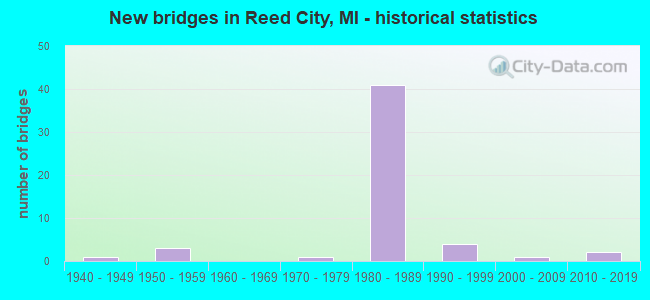
- New bridges - historical statistics
- 11940-1949
- 31950-1959
- 11970-1979
- 411980-1989
- 41990-1999
- 12000-2009
- 22010-2019

- Reconstructed bridges - Historical Statistics
- 11970-1979
- 11980-1989


- Bridge Condition - Deck
- 6.1%Very good
- 39.4%Good
- 51.5%Satisfactory
- 3.0%Fair

- Bridge Condition - Superstructure
- 14.7%Very good
- 44.1%Good
- 35.3%Satisfactory
- 5.9%Fair

- Bridge Condition - Substructure
- 5.9%Very good
- 58.8%Good
- 29.4%Satisfactory
- 5.9%Fair

- Bridge Condition - Channel
- 4.8%Very good
- 38.1%Good
- 38.1%Satisfactory
- 19.0%Fair

- Bridge Condition - Culverts
- 20.0%Very good
- 80.0%Good
Find on map >> Show street view
Structure Number: 854, Location: 7.2 MI E OF I-196 (Lat: 42.178750, Lng: -86.249975), Route carried "on" structure: Interstate 94, Year Built: 1959, Status: Open, Structure Length: 1.25m (4.10ft), Average Daily Traffic: 30,064 (year 2007), Truck Traffic: 27%, Average Future Daily Traffic: 42,736 (year 2018), Design Load: HS 20, Features Intersected: MILL CREEK
Minimum Vertical Clearance: 30.48m (100.00ft), Kilometerpoint: 4.576, Lanes on structure: 4, Base Highway Network: Yes (Inventory Route: 136, Subroute: 5), Owner: State Highway Agency, Approaching Roadway Width: 27.2m (89.2ft), Skew: 11 degrees, Material/Design: Concrete, Design/Construction: Tee Beam, Number Of Spans In Main Unit: 1, Length of Maximum Span: 12.5m (41.0ft), Curb-To-Curb Width: 42.0m (137.8ft), Out-to-Out Width: 62.0m (203.4ft)
Condition: Deck: Very good, Superstructure: Good, Substructure: Good, Channel: Fair, Operating Rating: 97.2 metric tons, Method Used To Determine Operating Rating: Load Factor (LF) rating reported by rating factor (RF) method using MS18 loading, Inventory Rating: 97.2 metric tons, Method Used To Determine Inventory Rating: Load Factor (LF) rating reported by rating factor (RF) method using MS18 loading, Structural Evaluation: Better than present minimum criteria, Deck Geometry: Superior to present desirable criteria, Waterway Adequacy: Better than present minimum criteria, Approach Roadway Alignment: Equal to present desirable criteria, Designated Inspection Frequency: Every 24 months, Inspection Date: April 2020, Deck Structure Type: Concrete Cast-file-Place
Find on map >> Show street view
Structure Number: 858, Location: 1.4 MI W OF THREE OAKS (Lat: 41.798892, Lng: -86.636825), Route carried "on" structure: US 12, Year Built: 2017, Status: Open, Structure Length: 0.68m (2.23ft), Average Daily Traffic: 5,975 (year 2017), Truck Traffic: 10%, Average Future Daily Traffic: 6,625 (year 2037), Design Load: Greater than HL93, Features Intersected: DEER CREEK
Minimum Vertical Clearance: 30.48m (100.00ft), Kilometerpoint: 7.014, Lanes on structure: 2, Base Highway Network: Yes (Inventory Route: 135, Subroute: 7), Owner: State Highway Agency, Approaching Roadway Width: 13.4m (44.0ft), Material/Design: Concrete, Design/Construction: Culvert, Number Of Spans In Main Unit: 1, Length of Maximum Span: 6.2m (20.3ft), Curb-To-Curb Width: 13.4m (44.0ft), Out-to-Out Width: 14.3m (46.9ft)
Condition: Channel: Fair, Culverts: Good, Operating Rating: 71.0 metric tons, Method Used To Determine Operating Rating: Load and Resistance Factor Rating (LRFR) rating reported by rating factor(RF) method using HL-93 loadings, Inventory Rating: 54.8 metric tons, Method Used To Determine Inventory Rating: Load and Resistance Factor Rating (LRFR) rating reported by rating factor(RF) method using HL-93 loadings, Structural Evaluation: Better than present minimum criteria, Deck Geometry: Equal to present minimum criteria, Waterway Adequacy: Equal to present minimum criteria, Approach Roadway Alignment: Equal to present desirable criteria, Designated Inspection Frequency: Every 24 months, Inspection Date: March 2020, Wearing Surface/Protective System: Wearing Surface: Bituminous
Find on map >> Show street view
Structure Number: 6726, Location: 1.4 MI N OF 22 MI RD (Lat: 43.805856, Lng: -85.533761), Route carried "on" structure: US 131, Year Built: 1984, Status: Open, Structure Length: 0.61m (2.00ft), Average Daily Traffic: 6,322 (year 2007), Truck Traffic: 12%, Average Future Daily Traffic: 10,456 (year 2018), Design Load: HS 20+Mod, Features Intersected: BUCKHORN CREEK
Minimum Vertical Clearance: 30.48m (100.00ft), Kilometerpoint: 38.408, Lanes on structure: 2, Base Highway Network: Yes (Inventory Route: 180, Subroute: 5), Owner: State Highway Agency, Approaching Roadway Width: 11.0m (36.1ft), Skew: 2 degrees, Material/Design: Steel, Design/Construction: Culvert, Number Of Spans In Main Unit: 1, Length of Maximum Span: 6.1m (20.0ft), Curb-To-Curb Width: 11.6m (38.1ft), Out-to-Out Width: 61.2m (200.8ft)
Condition: Channel: Satisfactory, Culverts: Good, Operating Rating: 97.2 metric tons, Method Used To Determine Operating Rating: Load Factor (LF) rating reported by rating factor (RF) method using MS18 loading, Inventory Rating: 97.2 metric tons, Method Used To Determine Inventory Rating: Load Factor (LF) rating reported by rating factor (RF) method using MS18 loading, Structural Evaluation: Better than present minimum criteria, Deck Geometry: Better than present minimum criteria, Waterway Adequacy: Better than present minimum criteria, Approach Roadway Alignment: Equal to present minimum criteria, Designated Inspection Frequency: Every 24 months, Inspection Date: January 2022
Find on map >> Show street view
Structure Number: 6727, Location: 1.4 MI N OF 22 MI RD (Lat: 43.805353, Lng: -85.535244), Route carried "on" structure: US 131, Year Built: 1984, Status: Open, Structure Length: 0.61m (2.00ft), Average Daily Traffic: 6,322 (year 2007), Truck Traffic: 12%, Average Future Daily Traffic: 10,456 (year 2018), Design Load: HS 20+Mod, Features Intersected: BUCKHORN CREEK
Minimum Vertical Clearance: 30.48m (100.00ft), Kilometerpoint: 38.333, Lanes on structure: 2, Base Highway Network: Yes (Inventory Route: 180, Subroute: 10), Owner: State Highway Agency, Approaching Roadway Width: 11.0m (36.1ft), Skew: 2 degrees, Material/Design: Steel, Design/Construction: Culvert, Number Of Spans In Main Unit: 1, Length of Maximum Span: 6.1m (20.0ft), Curb-To-Curb Width: 11.6m (38.1ft), Out-to-Out Width: 44.6m (146.3ft)
Condition: Channel: Satisfactory, Culverts: Good, Operating Rating: 97.2 metric tons, Method Used To Determine Operating Rating: Load Factor (LF) rating reported by rating factor (RF) method using MS18 loading, Inventory Rating: 97.2 metric tons, Method Used To Determine Inventory Rating: Load Factor (LF) rating reported by rating factor (RF) method using MS18 loading, Structural Evaluation: Better than present minimum criteria, Deck Geometry: Better than present minimum criteria, Waterway Adequacy: Better than present minimum criteria, Approach Roadway Alignment: Better than present minimum criteria, Designated Inspection Frequency: Every 24 months, Inspection Date: January 2022
Find on map >> Show street view
Structure Number: 854, Location: 0.26 MI S OF US-10 (Lat: 43.880383, Lng: -85.509947), Route carried "on" structure: Alternate US 131, Year Built: 1954, Status: Open, Structure Length: 3.04m (9.97ft), Average Daily Traffic: 5,735 (year 2007), Truck Traffic: 2%, Average Future Daily Traffic: 7,493 (year 2018), Design Load: HS 20, Features Intersected: HERSEY RIVER
Minimum Vertical Clearance: 30.48m (100.00ft), Kilometerpoint: 7.302, Lanes on structure: 4, Owner: State Highway Agency, Approaching Roadway Width: 15.9m (52.2ft), Material/Design: Steel, Design/Construction: Stringer/Multi-beam, Number Of Spans In Main Unit: 2, Length of Maximum Span: 15.2m (49.9ft), Curb or Sidewalk Widths: Left: 1.5m (4.9ft), Right: 1.5m (4.9ft), Curb-To-Curb Width: 14.6m (47.9ft), Out-to-Out Width: 18.4m (60.4ft)
Condition: Deck: Satisfactory, Superstructure: Fair, Substructure: Satisfactory, Channel: Satisfactory, Operating Rating: 66.1 metric tons, Method Used To Determine Operating Rating: Load Factor (LF) rating reported by rating factor (RF) method using MS18 loading, Inventory Rating: 39.5 metric tons, Method Used To Determine Inventory Rating: Load Factor (LF) rating reported by rating factor (RF) method using MS18 loading, Structural Evaluation: Somewhat better than minimum adequacy, Deck Geometry: High priority of replacement, Waterway Adequacy: Better than present minimum criteria, Approach Roadway Alignment: Equal to present desirable criteria, Designated Inspection Frequency: Every 24 months, Inspection Date: June 2021, Deck Structure Type: Concrete Cast-file-Place, Wearing Surface/Protective System: Wearing Surface: Bituminous, Membrane: Preformed Fabric
Find on map >> Show street view
Structure Number: 8551, Location: 1.5 MI NW OF REED CITY (Lat: 43.890189, Lng: -85.527631), Route carried "on" structure: US 131, Year Built: 1984, Status: Open, Structure Length: 3.32m (10.89ft), Average Daily Traffic: 6,391 (year 2007), Truck Traffic: 14%, Average Future Daily Traffic: 9,660 (year 2018), Design Load: HS 25 or greater, Features Intersected: JOHNSON CREEK
Minimum Vertical Clearance: 30.48m (100.00ft), Kilometerpoint: 8.462, Lanes on structure: 2, Base Highway Network: Yes (Inventory Route: 184, Subroute: 8), Owner: State Highway Agency, Approaching Roadway Width: 12.8m (42.0ft), Skew: 2 degrees, Material/Design: Prestressed concrete, Design/Construction: Stringer/Multi-beam, Number Of Spans In Main Unit: 1, Length of Maximum Span: 33.2m (108.9ft), Curb-To-Curb Width: 13.7m (44.9ft), Out-to-Out Width: 14.6m (47.9ft)
Condition: Deck: Good, Superstructure: Good, Substructure: Good, Channel: Satisfactory, Operating Rating: 84.9 metric tons, Method Used To Determine Operating Rating: Load Factor (LF) rating reported by rating factor (RF) method using MS18 loading, Inventory Rating: 43.1 metric tons, Method Used To Determine Inventory Rating: Load Factor (LF) rating reported by rating factor (RF) method using MS18 loading, Structural Evaluation: Better than present minimum criteria, Deck Geometry: Superior to present desirable criteria, Waterway Adequacy: Equal to present desirable criteria, Approach Roadway Alignment: Equal to present desirable criteria, Designated Inspection Frequency: Every 24 months, Inspection Date: June 2021, Deck Structure Type: Concrete Cast-file-Place, Wearing Surface/Protective System: Wearing Surface: Epoxy Overlay, Deck Protection: Epoxy Coated Reinforcing
Find on map >> Show street view
Structure Number: 8552, Location: 1.5 MI NW OF REED CITY (Lat: 43.890150, Lng: -85.528092), Route carried "on" structure: US 131, Year Built: 1984, Status: Open, Structure Length: 3.26m (10.70ft), Average Daily Traffic: 6,391 (year 2007), Truck Traffic: 14%, Average Future Daily Traffic: 9,660 (year 2018), Design Load: HS 25 or greater, Features Intersected: JOHNSON CREEK
Minimum Vertical Clearance: 30.48m (100.00ft), Kilometerpoint: 8.454, Lanes on structure: 3, Base Highway Network: Yes (Inventory Route: 184, Subroute: 9), Owner: State Highway Agency, Approaching Roadway Width: 13.7m (44.9ft), Skew: 1 degrees, Material/Design: Prestressed concrete, Design/Construction: Stringer/Multi-beam, Number Of Spans In Main Unit: 3, Length of Maximum Span: 17.6m (57.7ft), Curb-To-Curb Width: 19.2m (63.0ft), Out-to-Out Width: 20.7m (67.9ft)
Condition: Deck: Good, Superstructure: Very good, Substructure: Good, Channel: Good, Operating Rating: 59.3 metric tons, Method Used To Determine Operating Rating: Load Factor (LF) rating reported by rating factor (RF) method using MS18 loading, Inventory Rating: 35.6 metric tons, Method Used To Determine Inventory Rating: Load Factor (LF) rating reported by rating factor (RF) method using MS18 loading, Structural Evaluation: Better than present minimum criteria, Deck Geometry: Superior to present desirable criteria, Waterway Adequacy: Equal to present desirable criteria, Approach Roadway Alignment: Equal to present desirable criteria, Designated Inspection Frequency: Every 24 months, Inspection Date: August 2020, Deck Structure Type: Concrete Cast-file-Place, Wearing Surface/Protective System: Wearing Surface: Epoxy Overlay, Deck Protection: Epoxy Coated Reinforcing
Find on map >> Show street view
Structure Number: 8553, Location: 1.5 MI NW OF REED CITY (Lat: 43.890094, Lng: -85.526611), Route carried "on" structure: Ramp US 131, Year Built: 1984, Status: Open, Structure Length: 2.60m (8.53ft), Average Daily Traffic: 1,400 (year 1988), Truck Traffic: 3%, Average Future Daily Traffic: 1,610 (year 2008), Design Load: HS 25 or greater, Features Intersected: JOHNSON CREEK
Minimum Vertical Clearance: 30.48m (100.00ft), Kilometerpoint: 0.348, Lanes on structure: 1, Owner: State Highway Agency, Approaching Roadway Width: 10.1m (33.1ft), Skew: 3 degrees, Material/Design: Prestressed concrete, Design/Construction: Stringer/Multi-beam, Number Of Spans In Main Unit: 1, Length of Maximum Span: 25.6m (84.0ft), Curb-To-Curb Width: 9.8m (32.2ft), Out-to-Out Width: 10.9m (35.8ft)
Condition: Deck: Good, Superstructure: Good, Substructure: Good, Channel: Good, Operating Rating: 86.8 metric tons, Method Used To Determine Operating Rating: Load Factor (LF) rating reported by rating factor (RF) method using MS18 loading, Inventory Rating: 40.8 metric tons, Method Used To Determine Inventory Rating: Load Factor (LF) rating reported by rating factor (RF) method using MS18 loading, Structural Evaluation: Better than present minimum criteria, Deck Geometry: Superior to present desirable criteria, Waterway Adequacy: Equal to present desirable criteria, Approach Roadway Alignment: Equal to present desirable criteria, Designated Inspection Frequency: Every 24 months, Inspection Date: August 2020, Deck Structure Type: Concrete Cast-file-Place, Wearing Surface/Protective System: Wearing Surface: Epoxy Overlay, Deck Protection: Epoxy Coated Reinforcing
Find on map >> Show street view
Structure Number: 8554, Location: 1.5 MI NW OF REED CITY (Lat: 43.886497, Lng: -85.531997), Route carried "on" structure: Ramp US 131, Year Built: 1984, Status: Open, Structure Length: 2.83m (9.28ft), Average Daily Traffic: 1,400 (year 1988), Truck Traffic: 3%, Average Future Daily Traffic: 1,500 (year 1977), Design Load: HS 25 or greater, Features Intersected: JOHNSON CREEK
Minimum Vertical Clearance: 30.48m (100.00ft), Kilometerpoint: 0.389, Lanes on structure: 1, Owner: State Highway Agency, Approaching Roadway Width: 10.1m (33.1ft), Material/Design: Prestressed concrete, Design/Construction: Stringer/Multi-beam, Number Of Spans In Main Unit: 1, Length of Maximum Span: 28.3m (92.8ft), Curb-To-Curb Width: 9.8m (32.2ft), Out-to-Out Width: 10.9m (35.8ft)
Condition: Deck: Good, Superstructure: Good, Substructure: Good, Channel: Fair, Operating Rating: 85.5 metric tons, Method Used To Determine Operating Rating: Load Factor (LF) rating reported by rating factor (RF) method using MS18 loading, Inventory Rating: 46.0 metric tons, Method Used To Determine Inventory Rating: Load Factor (LF) rating reported by rating factor (RF) method using MS18 loading, Structural Evaluation: Better than present minimum criteria, Deck Geometry: Superior to present desirable criteria, Waterway Adequacy: Equal to present desirable criteria, Approach Roadway Alignment: Equal to present desirable criteria, Designated Inspection Frequency: Every 24 months, Inspection Date: June 2021, Deck Structure Type: Concrete Cast-file-Place, Wearing Surface/Protective System: Wearing Surface: Epoxy Overlay, Deck Protection: Epoxy Coated Reinforcing
Find on map >> Show street view
Structure Number: 8555, Location: 1.5 MI NW OF REED CITY (Lat: 43.883992, Lng: -85.527681), Route carried "on" structure: US 131, Year Built: 1984, Status: Open, Structure Length: 3.99m (13.09ft), Average Daily Traffic: 6,322 (year 2007), Truck Traffic: 12%, Average Future Daily Traffic: 10,456 (year 2018), Design Load: HS 25 or greater, Features Intersected: CSX RR (ABN)
Minimum Vertical Clearance: 30.48m (100.00ft), Kilometerpoint: 7.773, Lanes on structure: 2, Base Highway Network: Yes (Inventory Route: 184, Subroute: 8), Owner: State Highway Agency, Approaching Roadway Width: 12.8m (42.0ft), Skew: 1 degrees, Material/Design: Prestressed concrete, Design/Construction: Stringer/Multi-beam, Number Of Spans In Main Unit: 3, Length of Maximum Span: 13.7m (44.9ft), Curb-To-Curb Width: 13.7m (44.9ft), Out-to-Out Width: 14.6m (47.9ft)
Condition: Deck: Good, Superstructure: Good, Substructure: Good, Operating Rating: 69.0 metric tons, Method Used To Determine Operating Rating: Load Factor (LF) rating reported by rating factor (RF) method using MS18 loading, Inventory Rating: 41.1 metric tons, Method Used To Determine Inventory Rating: Load Factor (LF) rating reported by rating factor (RF) method using MS18 loading, Structural Evaluation: Better than present minimum criteria, Deck Geometry: Superior to present desirable criteria, Approach Roadway Alignment: Equal to present desirable criteria, Designated Inspection Frequency: Every 24 months, Inspection Date: September 2020, Deck Structure Type: Concrete Cast-file-Place, Wearing Surface/Protective System: Wearing Surface: Integral Concrete, Deck Protection: Epoxy Coated Reinforcing
Find on map >> Show street view
Structure Number: 8556, Location: 1.5 MI NW OF REED CITY (Lat: 43.884086, Lng: -85.528119), Route carried "on" structure: US 131, Year Built: 1984, Status: Open, Structure Length: 3.93m (12.89ft), Average Daily Traffic: 6,322 (year 2007), Truck Traffic: 12%, Average Future Daily Traffic: 10,456 (year 2018), Design Load: HS 25 or greater, Features Intersected: CSX RR (ABN)
Minimum Vertical Clearance: 30.48m (100.00ft), Kilometerpoint: 7.780, Lanes on structure: 2, Base Highway Network: Yes (Inventory Route: 184, Subroute: 9), Owner: State Highway Agency, Approaching Roadway Width: 12.8m (42.0ft), Skew: 1 degrees, Material/Design: Prestressed concrete, Design/Construction: Stringer/Multi-beam, Number Of Spans In Main Unit: 3, Length of Maximum Span: 13.7m (44.9ft), Curb-To-Curb Width: 13.7m (44.9ft), Out-to-Out Width: 14.6m (47.9ft)
Condition: Deck: Satisfactory, Superstructure: Satisfactory, Substructure: Satisfactory, Operating Rating: 64.2 metric tons, Method Used To Determine Operating Rating: Load Factor (LF) rating reported by rating factor (RF) method using MS18 loading, Inventory Rating: 38.2 metric tons, Method Used To Determine Inventory Rating: Load Factor (LF) rating reported by rating factor (RF) method using MS18 loading, Structural Evaluation: Equal to present minimum criteria, Deck Geometry: Superior to present desirable criteria, Approach Roadway Alignment: Equal to present desirable criteria, Designated Inspection Frequency: Every 24 months, Inspection Date: September 2020, Deck Structure Type: Concrete Cast-file-Place, Wearing Surface/Protective System: Wearing Surface: Epoxy Overlay, Deck Protection: Epoxy Coated Reinforcing
Find on map >> Show street view
Structure Number: 8557, Location: 1.5 MI NW OF REED CITY (Lat: 43.883819, Lng: -85.527044), Route carried "on" structure: Ramp US 131, Year Built: 1984, Status: Open, Structure Length: 3.87m (12.70ft), Average Daily Traffic: 1,400 (year 1988), Truck Traffic: 10%, Average Future Daily Traffic: 1,500 (year 1977), Design Load: HS 25 or greater, Features Intersected: CSX RR (ABN)
Minimum Vertical Clearance: 30.48m (100.00ft), Kilometerpoint: 0.361, Lanes on structure: 1, Owner: State Highway Agency, Approaching Roadway Width: 9.8m (32.2ft), Material/Design: Prestressed concrete, Design/Construction: Stringer/Multi-beam, Number Of Spans In Main Unit: 3, Length of Maximum Span: 13.7m (44.9ft), Curb-To-Curb Width: 9.8m (32.2ft), Out-to-Out Width: 10.9m (35.8ft)
Condition: Deck: Good, Superstructure: Good, Substructure: Good, Operating Rating: 67.4 metric tons, Method Used To Determine Operating Rating: Load Factor (LF) rating reported by rating factor (RF) method using MS18 loading, Inventory Rating: 40.2 metric tons, Method Used To Determine Inventory Rating: Load Factor (LF) rating reported by rating factor (RF) method using MS18 loading, Structural Evaluation: Better than present minimum criteria, Deck Geometry: Superior to present desirable criteria, Approach Roadway Alignment: Equal to present desirable criteria, Designated Inspection Frequency: Every 24 months, Inspection Date: September 2020, Deck Structure Type: Concrete Cast-file-Place, Wearing Surface/Protective System: Wearing Surface: Epoxy Overlay, Deck Protection: Epoxy Coated Reinforcing
Find on map >> Show street view
Structure Number: 8558, Location: 1.5 MI NW OF REED CITY (Lat: 43.884239, Lng: -85.529136), Route carried "on" structure: Ramp US 131, Year Built: 1984, Status: Open, Structure Length: 5.33m (17.49ft), Average Daily Traffic: 1,500 (year 1988), Truck Traffic: 10%, Average Future Daily Traffic: 1,550 (year 1977), Design Load: HS 25 or greater, Features Intersected: CSX RR (ABN)
Minimum Vertical Clearance: 30.48m (100.00ft), Kilometerpoint: 0.729, Lanes on structure: 1, Owner: State Highway Agency, Approaching Roadway Width: 9.8m (32.2ft), Skew: 4 degrees, Material/Design: Prestressed concrete, Design/Construction: Stringer/Multi-beam, Number Of Spans In Main Unit: 3, Length of Maximum Span: 18.6m (61.0ft), Curb-To-Curb Width: 9.8m (32.2ft), Out-to-Out Width: 10.9m (35.8ft)
Condition: Deck: Satisfactory, Superstructure: Good, Substructure: Satisfactory, Operating Rating: 74.2 metric tons, Method Used To Determine Operating Rating: Load Factor (LF) rating reported by rating factor (RF) method using MS18 loading, Inventory Rating: 43.7 metric tons, Method Used To Determine Inventory Rating: Load Factor (LF) rating reported by rating factor (RF) method using MS18 loading, Structural Evaluation: Equal to present minimum criteria, Deck Geometry: Superior to present desirable criteria, Approach Roadway Alignment: Equal to present desirable criteria, Designated Inspection Frequency: Every 24 months, Inspection Date: September 2020, Deck Structure Type: Concrete Cast-file-Place, Wearing Surface/Protective System: Wearing Surface: Epoxy Overlay, Deck Protection: Epoxy Coated Reinforcing
Find on map >> Show street view
Structure Number: 8559, Location: 4 MILES S OF REED CITY (Lat: 43.815611, Lng: -85.536089), Route carried "on" structure: US 131, Year Built: 1984, Status: Open, Structure Length: 2.74m (8.99ft), Average Daily Traffic: 6,322 (year 2007), Truck Traffic: 12%, Average Future Daily Traffic: 10,456 (year 2018), Design Load: HS 25 or greater, Features Intersected: MECEOLA ROAD
Minimum Vertical Clearance: 30.48m (100.00ft), Kilometerpoint: 0.000, Lanes on structure: 2, Lanes under structure: 2, Base Highway Network: Yes (Inventory Route: 184, Subroute: 8), Owner: State Highway Agency, Approaching Roadway Width: 14.0m (45.9ft), Material/Design: Steel, Design/Construction: Stringer/Multi-beam, Number Of Spans In Main Unit: 1, Length of Maximum Span: 27.4m (89.9ft), Curb-To-Curb Width: 13.9m (45.6ft), Out-to-Out Width: 14.6m (47.9ft)
Condition: Deck: Satisfactory, Superstructure: Fair, Substructure: Satisfactory, Operating Rating: 85.9 metric tons, Method Used To Determine Operating Rating: Load Factor (LF) rating reported by rating factor (RF) method using MS18 loading, Inventory Rating: 51.5 metric tons, Method Used To Determine Inventory Rating: Load Factor (LF) rating reported by rating factor (RF) method using MS18 loading, Structural Evaluation: Somewhat better than minimum adequacy, Deck Geometry: Superior to present desirable criteria, Underclear: Somewhat better than minimum adequacy, Approach Roadway Alignment: Better than present minimum criteria, Designated Inspection Frequency: Every 24 months, Inspection Date: June 2021, Deck Structure Type: Concrete Cast-file-Place, Wearing Surface/Protective System: Wearing Surface: Epoxy Overlay, Deck Protection: Epoxy Coated Reinforcing
Find on map >> Show street view
Structure Number: 856, Location: 4 MILE S OF REED CITY (Lat: 43.815594, Lng: -85.538000), Route carried "on" structure: US 131, Year Built: 1984, Status: Open, Structure Length: 2.83m (9.28ft), Average Daily Traffic: 6,322 (year 2007), Truck Traffic: 12%, Average Future Daily Traffic: 10,456 (year 2018), Design Load: HS 25 or greater, Features Intersected: MECEOLA ROAD
Minimum Vertical Clearance: 30.48m (100.00ft), Kilometerpoint: 0.000, Lanes on structure: 2, Lanes under structure: 2, Base Highway Network: Yes (Inventory Route: 184, Subroute: 9), Owner: State Highway Agency, Approaching Roadway Width: 14.0m (45.9ft), Material/Design: Steel, Design/Construction: Stringer/Multi-beam, Number Of Spans In Main Unit: 1, Length of Maximum Span: 27.4m (89.9ft), Curb-To-Curb Width: 13.8m (45.3ft), Out-to-Out Width: 14.6m (47.9ft)
Condition: Deck: Satisfactory, Superstructure: Good, Substructure: Good, Operating Rating: 97.2 metric tons, Method Used To Determine Operating Rating: Load Factor (LF) rating reported by rating factor (RF) method using MS18 loading, Inventory Rating: 68.4 metric tons, Method Used To Determine Inventory Rating: Load Factor (LF) rating reported by rating factor (RF) method using MS18 loading, Structural Evaluation: Better than present minimum criteria, Deck Geometry: Superior to present desirable criteria, Underclear: Somewhat better than minimum adequacy, Approach Roadway Alignment: Equal to present desirable criteria, Designated Inspection Frequency: Every 24 months, Inspection Date: June 2021, Deck Structure Type: Concrete Cast-file-Place, Wearing Surface/Protective System: Wearing Surface: Epoxy Overlay, Deck Protection: Epoxy Coated Reinforcing
Find on map >> Show street view
Structure Number: 8561, Location: 2.5 MI SW REED CITY (Lat: 43.844506, Lng: -85.530803), Route carried "on" structure: US 131, Year Built: 1984, Status: Open, Structure Length: 3.04m (9.97ft), Average Daily Traffic: 6,322 (year 2007), Truck Traffic: 12%, Average Future Daily Traffic: 10,456 (year 2018), Design Load: HS 25 or greater, Features Intersected: HERSEY RD (2 MILE RD)
Minimum Vertical Clearance: 30.48m (100.00ft), Kilometerpoint: 3.251, Lanes on structure: 2, Lanes under structure: 2, Base Highway Network: Yes (Inventory Route: 184, Subroute: 8), Owner: State Highway Agency, Approaching Roadway Width: 14.6m (47.9ft), Skew: 1 degrees, Material/Design: Steel, Design/Construction: Stringer/Multi-beam, Number Of Spans In Main Unit: 1, Length of Maximum Span: 30.4m (99.7ft), Curb-To-Curb Width: 13.6m (44.6ft), Out-to-Out Width: 14.6m (47.9ft)
Condition: Deck: Good, Superstructure: Good, Substructure: Good, Operating Rating: 97.2 metric tons, Method Used To Determine Operating Rating: Load Factor (LF) rating reported by rating factor (RF) method using MS18 loading, Inventory Rating: 70.6 metric tons, Method Used To Determine Inventory Rating: Load Factor (LF) rating reported by rating factor (RF) method using MS18 loading, Structural Evaluation: Better than present minimum criteria, Deck Geometry: Superior to present desirable criteria, Underclear: Somewhat better than minimum adequacy, Approach Roadway Alignment: Equal to present desirable criteria, Designated Inspection Frequency: Every 24 months, Inspection Date: June 2021, Deck Structure Type: Concrete Cast-file-Place, Wearing Surface/Protective System: Wearing Surface: Integral Concrete, Deck Protection: Epoxy Coated Reinforcing
Find on map >> Show street view
Structure Number: 8562, Location: 2.5 MI SW OF REED CITY (Lat: 43.844500, Lng: -85.532531), Route carried "on" structure: US 131, Year Built: 1984, Status: Open, Structure Length: 3.17m (10.40ft), Average Daily Traffic: 6,322 (year 2007), Truck Traffic: 12%, Average Future Daily Traffic: 10,456 (year 2018), Design Load: HS 25 or greater, Features Intersected: HERSEY RD (2 MILE RD)
Minimum Vertical Clearance: 30.48m (100.00ft), Kilometerpoint: 3.246, Lanes on structure: 2, Lanes under structure: 2, Base Highway Network: Yes (Inventory Route: 184, Subroute: 9), Owner: State Highway Agency, Approaching Roadway Width: 14.1m (46.3ft), Skew: 1 degrees, Material/Design: Steel, Design/Construction: Stringer/Multi-beam, Number Of Spans In Main Unit: 1, Length of Maximum Span: 31.7m (104.0ft), Curb-To-Curb Width: 13.6m (44.6ft), Out-to-Out Width: 14.6m (47.9ft)
Condition: Deck: Good, Superstructure: Satisfactory, Substructure: Good, Operating Rating: 89.7 metric tons, Method Used To Determine Operating Rating: Load Factor (LF) rating reported by rating factor (RF) method using MS18 loading, Inventory Rating: 53.8 metric tons, Method Used To Determine Inventory Rating: Load Factor (LF) rating reported by rating factor (RF) method using MS18 loading, Structural Evaluation: Equal to present minimum criteria, Deck Geometry: Superior to present desirable criteria, Underclear: Somewhat better than minimum adequacy, Approach Roadway Alignment: Equal to present desirable criteria, Designated Inspection Frequency: Every 24 months, Inspection Date: June 2020, Deck Structure Type: Concrete Cast-file-Place, Wearing Surface/Protective System: Wearing Surface: Latex Concrete, Deck Protection: Epoxy Coated Reinforcing
Find on map >> Show street view
Structure Number: 8563, Location: 2.0 MI SW OF REED CITY (Lat: 43.858903, Lng: -85.533889), Route carried "on" structure: US 131, Year Built: 1984, Status: Open, Structure Length: 3.17m (10.40ft), Average Daily Traffic: 6,322 (year 2007), Truck Traffic: 12%, Average Future Daily Traffic: 10,456 (year 2018), Design Load: HS 25 or greater, Features Intersected: PECK LAKE RD (3 MILE RD)
Minimum Vertical Clearance: 30.48m (100.00ft), Kilometerpoint: 4.886, Lanes on structure: 2, Lanes under structure: 2, Base Highway Network: Yes (Inventory Route: 184, Subroute: 8), Owner: State Highway Agency, Approaching Roadway Width: 14.6m (47.9ft), Skew: 1 degrees, Material/Design: Steel, Design/Construction: Stringer/Multi-beam, Number Of Spans In Main Unit: 1, Length of Maximum Span: 31.7m (104.0ft), Curb-To-Curb Width: 13.6m (44.6ft), Out-to-Out Width: 14.6m (47.9ft)
Condition: Deck: Satisfactory, Superstructure: Good, Substructure: Good, Operating Rating: 89.4 metric tons, Method Used To Determine Operating Rating: Load Factor (LF) rating reported by rating factor (RF) method using MS18 loading, Inventory Rating: 53.5 metric tons, Method Used To Determine Inventory Rating: Load Factor (LF) rating reported by rating factor (RF) method using MS18 loading, Structural Evaluation: Better than present minimum criteria, Deck Geometry: Superior to present desirable criteria, Underclear: Equal to present minimum criteria, Approach Roadway Alignment: Equal to present desirable criteria, Designated Inspection Frequency: Every 24 months, Inspection Date: June 2020, Deck Structure Type: Concrete Cast-file-Place, Wearing Surface/Protective System: Wearing Surface: Epoxy Overlay, Deck Protection: Epoxy Coated Reinforcing
Find on map >> Show street view
Structure Number: 8564, Location: 2.0 MI SW OF REED CITY (Lat: 43.858908, Lng: -85.535075), Route carried "on" structure: US 131, Year Built: 1984, Status: Open, Structure Length: 2.98m (9.78ft), Average Daily Traffic: 6,322 (year 2007), Truck Traffic: 12%, Average Future Daily Traffic: 10,456 (year 2018), Design Load: HS 25 or greater, Features Intersected: PECK LAKE RD (3 MILE RD)
Minimum Vertical Clearance: 30.48m (100.00ft), Kilometerpoint: 4.873, Lanes on structure: 2, Lanes under structure: 2, Base Highway Network: Yes (Inventory Route: 184, Subroute: 9), Owner: State Highway Agency, Approaching Roadway Width: 14.6m (47.9ft), Material/Design: Steel, Design/Construction: Stringer/Multi-beam, Number Of Spans In Main Unit: 1, Length of Maximum Span: 29.8m (97.8ft), Curb-To-Curb Width: 13.6m (44.6ft), Out-to-Out Width: 14.6m (47.9ft)
Condition: Deck: Satisfactory, Superstructure: Very good, Substructure: Good, Operating Rating: 87.2 metric tons, Method Used To Determine Operating Rating: Load Factor (LF) rating reported by rating factor (RF) method using MS18 loading, Inventory Rating: 52.2 metric tons, Method Used To Determine Inventory Rating: Load Factor (LF) rating reported by rating factor (RF) method using MS18 loading, Structural Evaluation: Better than present minimum criteria, Deck Geometry: Superior to present desirable criteria, Underclear: Equal to present minimum criteria, Approach Roadway Alignment: Equal to present desirable criteria, Designated Inspection Frequency: Every 24 months, Inspection Date: June 2020, Deck Structure Type: Concrete Cast-file-Place, Wearing Surface/Protective System: Wearing Surface: Integral Concrete, Deck Protection: Epoxy Coated Reinforcing
Find on map >> Show street view
Structure Number: 8565, Location: 0.5 MI W OF REED CITY (Lat: 43.873122, Lng: -85.529294), Route carried "on" structure: US 131, Year Built: 1984, Status: Open, Structure Length: 3.04m (9.97ft), Average Daily Traffic: 6,322 (year 2007), Truck Traffic: 12%, Average Future Daily Traffic: 10,456 (year 2018), Design Load: HS 25 or greater, Features Intersected: CHIPPEWA RD (4 MILE RD)
Minimum Vertical Clearance: 30.48m (100.00ft), Kilometerpoint: 6.549, Lanes on structure: 2, Lanes under structure: 2, Base Highway Network: Yes (Inventory Route: 184, Subroute: 8), Owner: State Highway Agency, Approaching Roadway Width: 14.6m (47.9ft), Material/Design: Steel, Design/Construction: Stringer/Multi-beam, Number Of Spans In Main Unit: 1, Length of Maximum Span: 30.4m (99.7ft), Curb-To-Curb Width: 13.7m (44.9ft), Out-to-Out Width: 14.7m (48.2ft)
Condition: Deck: Satisfactory, Superstructure: Satisfactory, Substructure: Satisfactory, Operating Rating: 86.8 metric tons, Method Used To Determine Operating Rating: Load Factor (LF) rating reported by rating factor (RF) method using MS18 loading, Inventory Rating: 51.8 metric tons, Method Used To Determine Inventory Rating: Load Factor (LF) rating reported by rating factor (RF) method using MS18 loading, Structural Evaluation: Equal to present minimum criteria, Deck Geometry: Superior to present desirable criteria, Underclear: Equal to present minimum criteria, Approach Roadway Alignment: Equal to present desirable criteria, Designated Inspection Frequency: Every 24 months, Inspection Date: June 2020, Deck Structure Type: Concrete Cast-file-Place, Wearing Surface/Protective System: Wearing Surface: Epoxy Overlay, Deck Protection: Epoxy Coated Reinforcing
Find on map >> Show street view
Structure Number: 8566, Location: 0.5 MI W OF REED CITY (Lat: 43.873136, Lng: -85.530789), Route carried "on" structure: US 131, Year Built: 1984, Status: Open, Structure Length: 3.04m (9.97ft), Average Daily Traffic: 6,322 (year 2007), Truck Traffic: 12%, Average Future Daily Traffic: 10,456 (year 2018), Design Load: HS 25 or greater, Features Intersected: CHIPPEWA RD (4 MILE RD)
Minimum Vertical Clearance: 30.48m (100.00ft), Kilometerpoint: 6.531, Lanes on structure: 2, Lanes under structure: 2, Base Highway Network: Yes (Inventory Route: 184, Subroute: 9), Owner: State Highway Agency, Approaching Roadway Width: 14.6m (47.9ft), Material/Design: Steel, Design/Construction: Stringer/Multi-beam, Number Of Spans In Main Unit: 1, Length of Maximum Span: 30.4m (99.7ft), Curb-To-Curb Width: 13.6m (44.6ft), Out-to-Out Width: 14.6m (47.9ft)
Condition: Deck: Satisfactory, Superstructure: Satisfactory, Substructure: Good, Operating Rating: 86.8 metric tons, Method Used To Determine Operating Rating: Load Factor (LF) rating reported by rating factor (RF) method using MS18 loading, Inventory Rating: 51.8 metric tons, Method Used To Determine Inventory Rating: Load Factor (LF) rating reported by rating factor (RF) method using MS18 loading, Structural Evaluation: Equal to present minimum criteria, Deck Geometry: Superior to present desirable criteria, Underclear: Equal to present minimum criteria, Approach Roadway Alignment: Equal to present desirable criteria, Designated Inspection Frequency: Every 24 months, Inspection Date: June 2020, Deck Structure Type: Concrete Cast-file-Place, Wearing Surface/Protective System: Wearing Surface: Monolithic Concrete, Deck Protection: Epoxy Coated Reinforcing
Find on map >> Show street view
Structure Number: 8567, Location: 1.5 MI NW OF REED CITY (Lat: 43.887433, Lng: -85.527653), Route carried "on" structure: US 131, Year Built: 1984, Status: Open, Structure Length: 3.38m (11.09ft), Average Daily Traffic: 6,391 (year 2007), Truck Traffic: 14%, Average Future Daily Traffic: 9,660 (year 2018), Design Load: HS 25 or greater, Features Intersected: US-10
Minimum Vertical Clearance: 30.48m (100.00ft), Kilometerpoint: 8.155, Lanes on structure: 2, Lanes under structure: 2, Base Highway Network: Yes (Inventory Route: 184, Subroute: 8), Owner: State Highway Agency, Approaching Roadway Width: 14.6m (47.9ft), Material/Design: Prestressed concrete, Design/Construction: Stringer/Multi-beam, Number Of Spans In Main Unit: 1, Length of Maximum Span: 33.8m (110.9ft), Curb-To-Curb Width: 13.4m (44.0ft), Out-to-Out Width: 14.4m (47.2ft)
Condition: Deck: Good, Superstructure: Satisfactory, Substructure: Good, Operating Rating: 72.3 metric tons, Method Used To Determine Operating Rating: Load Factor (LF) rating reported by rating factor (RF) method using MS18 loading, Inventory Rating: 43.4 metric tons, Method Used To Determine Inventory Rating: Load Factor (LF) rating reported by rating factor (RF) method using MS18 loading, Structural Evaluation: Equal to present minimum criteria, Deck Geometry: Superior to present desirable criteria, Underclear: Meets minimum limits, Approach Roadway Alignment: Equal to present desirable criteria, Designated Inspection Frequency: Every 24 months, Inspection Date: June 2020, Deck Structure Type: Concrete Cast-file-Place, Wearing Surface/Protective System: Wearing Surface: Epoxy Overlay, Deck Protection: Epoxy Coated Reinforcing
Find on map >> Show street view
Structure Number: 8568, Location: 1.5 MI NW OF REED CITY (Lat: 43.887433, Lng: -85.528111), Route carried "on" structure: US 131, Year Built: 1984, Status: Open, Structure Length: 3.29m (10.79ft), Average Daily Traffic: 6,391 (year 2007), Truck Traffic: 14%, Average Future Daily Traffic: 9,660 (year 2018), Design Load: HS 25 or greater, Features Intersected: US-10
Minimum Vertical Clearance: 30.48m (100.00ft), Kilometerpoint: 8.152, Lanes on structure: 2, Lanes under structure: 2, Base Highway Network: Yes (Inventory Route: 184, Subroute: 9), Owner: State Highway Agency, Approaching Roadway Width: 14.6m (47.9ft), Material/Design: Prestressed concrete, Design/Construction: Stringer/Multi-beam, Number Of Spans In Main Unit: 1, Length of Maximum Span: 32.9m (107.9ft), Curb-To-Curb Width: 15.8m (51.8ft), Out-to-Out Width: 16.2m (53.1ft)
Condition: Deck: Good, Superstructure: Good, Substructure: Good, Operating Rating: 69.0 metric tons, Method Used To Determine Operating Rating: Load Factor (LF) rating reported by rating factor (RF) method using MS18 loading, Inventory Rating: 38.6 metric tons, Method Used To Determine Inventory Rating: Load Factor (LF) rating reported by rating factor (RF) method using MS18 loading, Structural Evaluation: Better than present minimum criteria, Deck Geometry: Superior to present desirable criteria, Underclear: Somewhat better than minimum adequacy, Approach Roadway Alignment: Equal to present desirable criteria, Designated Inspection Frequency: Every 24 months, Inspection Date: June 2020, Deck Structure Type: Concrete Cast-file-Place, Wearing Surface/Protective System: Wearing Surface: Monolithic Concrete, Deck Protection: Epoxy Coated Reinforcing
Find on map >> Show street view
Structure Number: 8569, Location: 2.4 MI N OF REED CITY (Lat: 43.914275, Lng: -85.521933), Route carried "on" structure: US 131, Year Built: 1985, Status: Open, Structure Length: 3.81m (12.50ft), Average Daily Traffic: 11,841 (year 2013), Truck Traffic: 10%, Average Future Daily Traffic: 9,660 (year 2018), Design Load: HS 25 or greater, Features Intersected: HERSEY CREEK
Minimum Vertical Clearance: 30.48m (100.00ft), Kilometerpoint: 11.190, Lanes on structure: 2, Base Highway Network: Yes (Inventory Route: 184, Subroute: 8), Owner: State Highway Agency, Approaching Roadway Width: 14.0m (45.9ft), Skew: 2 degrees, Material/Design: Prestressed concrete, Design/Construction: Stringer/Multi-beam, Number Of Spans In Main Unit: 3, Length of Maximum Span: 18.3m (60.0ft), Curb-To-Curb Width: 13.4m (44.0ft), Out-to-Out Width: 14.4m (47.2ft)
Condition: Deck: Good, Superstructure: Satisfactory, Substructure: Good, Channel: Good, Operating Rating: 71.3 metric tons, Method Used To Determine Operating Rating: Load Factor (LF) rating reported by rating factor (RF) method using MS18 loading, Inventory Rating: 42.8 metric tons, Method Used To Determine Inventory Rating: Load Factor (LF) rating reported by rating factor (RF) method using MS18 loading, Structural Evaluation: Equal to present minimum criteria, Deck Geometry: Superior to present desirable criteria, Waterway Adequacy: Equal to present desirable criteria, Approach Roadway Alignment: Better than present minimum criteria, Designated Inspection Frequency: Every 24 months, Inspection Date: August 2020, Deck Structure Type: Concrete Cast-file-Place, Wearing Surface/Protective System: Wearing Surface: Epoxy Overlay, Deck Protection: Epoxy Coated Reinforcing
Find on map >> Show street view
Structure Number: 857, Location: 2.4 MI N OF REED CITY (Lat: 43.914567, Lng: -85.522281), Route carried "on" structure: US 131, Year Built: 1985, Status: Open, Structure Length: 3.81m (12.50ft), Average Daily Traffic: 11,841 (year 2013), Truck Traffic: 10%, Average Future Daily Traffic: 9,660 (year 2018), Design Load: HS 25 or greater, Features Intersected: HERSEY CREEK
Minimum Vertical Clearance: 30.48m (100.00ft), Kilometerpoint: 11.221, Lanes on structure: 2, Base Highway Network: Yes (Inventory Route: 184, Subroute: 9), Owner: State Highway Agency, Approaching Roadway Width: 13.4m (44.0ft), Skew: 2 degrees, Material/Design: Prestressed concrete, Design/Construction: Stringer/Multi-beam, Number Of Spans In Main Unit: 3, Length of Maximum Span: 18.3m (60.0ft), Curb-To-Curb Width: 13.4m (44.0ft), Out-to-Out Width: 14.4m (47.2ft)
Condition: Deck: Satisfactory, Superstructure: Satisfactory, Substructure: Good, Channel: Good, Operating Rating: 64.5 metric tons, Method Used To Determine Operating Rating: Load Factor (LF) rating reported by rating factor (RF) method using MS18 loading, Inventory Rating: 38.6 metric tons, Method Used To Determine Inventory Rating: Load Factor (LF) rating reported by rating factor (RF) method using MS18 loading, Structural Evaluation: Equal to present minimum criteria, Deck Geometry: Superior to present desirable criteria, Waterway Adequacy: Better than present minimum criteria, Approach Roadway Alignment: Equal to present desirable criteria, Designated Inspection Frequency: Every 24 months, Inspection Date: August 2020, Deck Structure Type: Concrete Cast-file-Place, Wearing Surface/Protective System: Wearing Surface: Monolithic Concrete, Deck Protection: Epoxy Coated Reinforcing
Find on map >> Show street view
Structure Number: 8573, Location: 4.5 MI N OF REED CITY (Lat: 43.944631, Lng: -85.520861), Route carried "on" structure: US 131, Year Built: 1985, Status: Open, Structure Length: 2.90m (9.51ft), Average Daily Traffic: 6,391 (year 2007), Truck Traffic: 14%, Average Future Daily Traffic: 9,660 (year 2018), Design Load: HS 25 or greater, Features Intersected: PENASHA RD (9 MILE RD)
Minimum Vertical Clearance: 30.48m (100.00ft), Kilometerpoint: 14.639, Lanes on structure: 2, Lanes under structure: 2, Base Highway Network: Yes (Inventory Route: 184, Subroute: 8), Owner: State Highway Agency, Approaching Roadway Width: 14.0m (45.9ft), Skew: 2 degrees, Material/Design: Steel, Design/Construction: Stringer/Multi-beam, Number Of Spans In Main Unit: 1, Length of Maximum Span: 28.9m (94.8ft), Curb-To-Curb Width: 13.6m (44.6ft), Out-to-Out Width: 14.6m (47.9ft)
Condition: Deck: Satisfactory, Superstructure: Satisfactory, Substructure: Satisfactory, Operating Rating: 72.3 metric tons, Method Used To Determine Operating Rating: Load Factor (LF) rating reported by rating factor (RF) method using MS18 loading, Inventory Rating: 43.1 metric tons, Method Used To Determine Inventory Rating: Load Factor (LF) rating reported by rating factor (RF) method using MS18 loading, Structural Evaluation: Equal to present minimum criteria, Deck Geometry: Superior to present desirable criteria, Underclear: Equal to present minimum criteria, Approach Roadway Alignment: Better than present minimum criteria, Designated Inspection Frequency: Every 18 months, Inspection Date: November 2020, Deck Structure Type: Concrete Cast-file-Place, Wearing Surface/Protective System: Wearing Surface: Epoxy Overlay, Deck Protection: Epoxy Coated Reinforcing
Find on map >> Show street view
Structure Number: 8575, Location: 2.5 MI N OF REED CITY (Lat: 43.916275, Lng: -85.521147), Route carried "on" structure: US 131, Year Built: 1985, Status: Open, Structure Length: 3.23m (10.60ft), Average Daily Traffic: 6,391 (year 2007), Truck Traffic: 14%, Average Future Daily Traffic: 9,660 (year 2018), Design Load: HS 25 or greater, Features Intersected: GRAND AVE (7 MILE RD)
Minimum Vertical Clearance: 30.48m (100.00ft), Kilometerpoint: 11.420, Lanes on structure: 2, Lanes under structure: 2, Base Highway Network: Yes (Inventory Route: 184, Subroute: 8), Owner: State Highway Agency, Approaching Roadway Width: 13.7m (44.9ft), Skew: 2 degrees, Material/Design: Steel, Design/Construction: Stringer/Multi-beam, Number Of Spans In Main Unit: 1, Length of Maximum Span: 32.3m (106.0ft), Curb-To-Curb Width: 13.5m (44.3ft), Out-to-Out Width: 14.4m (47.2ft)
Condition: Deck: Satisfactory, Superstructure: Satisfactory, Substructure: Satisfactory, Operating Rating: 70.6 metric tons, Method Used To Determine Operating Rating: Load Factor (LF) rating reported by rating factor (RF) method using MS18 loading, Inventory Rating: 42.4 metric tons, Method Used To Determine Inventory Rating: Load Factor (LF) rating reported by rating factor (RF) method using MS18 loading, Structural Evaluation: Equal to present minimum criteria, Deck Geometry: Superior to present desirable criteria, Underclear: Equal to present minimum criteria, Approach Roadway Alignment: Better than present minimum criteria, Designated Inspection Frequency: Every 24 months, Inspection Date: September 2021, Deck Structure Type: Concrete Cast-file-Place, Wearing Surface/Protective System: Wearing Surface: Epoxy Overlay, Deck Protection: Epoxy Coated Reinforcing
Find on map >> Show street view
Structure Number: 8576, Location: 2.5 MI N OF REED CITY (Lat: 43.916239, Lng: -85.521647), Route carried "on" structure: US 131, Year Built: 1985, Status: Open, Structure Length: 3.23m (10.60ft), Average Daily Traffic: 6,391 (year 2007), Truck Traffic: 14%, Average Future Daily Traffic: 9,660 (year 2018), Design Load: HS 25 or greater, Features Intersected: GRAND AVE (7 MILE RD)
Minimum Vertical Clearance: 30.48m (100.00ft), Kilometerpoint: 11.414, Lanes on structure: 2, Lanes under structure: 2, Base Highway Network: Yes (Inventory Route: 184, Subroute: 9), Owner: State Highway Agency, Approaching Roadway Width: 13.7m (44.9ft), Skew: 2 degrees, Material/Design: Steel, Design/Construction: Stringer/Multi-beam, Number Of Spans In Main Unit: 1, Length of Maximum Span: 32.3m (106.0ft), Curb-To-Curb Width: 13.5m (44.3ft), Out-to-Out Width: 14.4m (47.2ft)
Condition: Deck: Satisfactory, Superstructure: Good, Substructure: Good, Operating Rating: 97.2 metric tons, Method Used To Determine Operating Rating: Load Factor (LF) rating reported by rating factor (RF) method using MS18 loading, Inventory Rating: 59.6 metric tons, Method Used To Determine Inventory Rating: Load Factor (LF) rating reported by rating factor (RF) method using MS18 loading, Structural Evaluation: Better than present minimum criteria, Deck Geometry: Superior to present desirable criteria, Underclear: Equal to present minimum criteria, Approach Roadway Alignment: Better than present minimum criteria, Designated Inspection Frequency: Every 24 months, Inspection Date: September 2021, Deck Structure Type: Concrete Cast-file-Place, Wearing Surface/Protective System: Wearing Surface: Epoxy Overlay, Deck Protection: Epoxy Coated Reinforcing
Find on map >> Show street view
Structure Number: 8577, Location: 4.5 MI N OF REED CITY (Lat: 43.944619, Lng: -85.521392), Route carried "on" structure: US 131, Year Built: 1985, Status: Open, Structure Length: 2.87m (9.42ft), Average Daily Traffic: 6,391 (year 2007), Truck Traffic: 14%, Average Future Daily Traffic: 9,660 (year 2018), Design Load: HS 25 or greater, Features Intersected: PENASHA RD (9 MILE RD)
Minimum Vertical Clearance: 30.48m (100.00ft), Kilometerpoint: 14.620, Lanes on structure: 2, Lanes under structure: 2, Base Highway Network: Yes (Inventory Route: 184, Subroute: 9), Owner: State Highway Agency, Approaching Roadway Width: 13.4m (44.0ft), Skew: 2 degrees, Material/Design: Steel, Design/Construction: Stringer/Multi-beam, Number Of Spans In Main Unit: 1, Length of Maximum Span: 28.6m (93.8ft), Curb-To-Curb Width: 13.6m (44.6ft), Out-to-Out Width: 14.6m (47.9ft)
Condition: Deck: Satisfactory, Superstructure: Good, Substructure: Good, Operating Rating: 71.9 metric tons, Method Used To Determine Operating Rating: Load Factor (LF) rating reported by rating factor (RF) method using MS18 loading, Inventory Rating: 43.1 metric tons, Method Used To Determine Inventory Rating: Load Factor (LF) rating reported by rating factor (RF) method using MS18 loading, Structural Evaluation: Better than present minimum criteria, Deck Geometry: Superior to present desirable criteria, Underclear: Equal to present minimum criteria, Approach Roadway Alignment: Better than present minimum criteria, Designated Inspection Frequency: Every 24 months, Inspection Date: September 2020, Deck Structure Type: Concrete Cast-file-Place, Wearing Surface/Protective System: Wearing Surface: Monolithic Concrete, Deck Protection: Epoxy Coated Reinforcing
Find on map >> Show street view
Structure Number: 8578, Location: 1.8 MI NW OF REED CITY (Lat: 43.887450, Lng: -85.530206), Route carried "on" structure: US 10, Year Built: 1947, Year Reconstructed: 1984, Status: Open, Structure Length: 1.06m (3.48ft), Average Daily Traffic: 5,822 (year 2007), Truck Traffic: 7%, Average Future Daily Traffic: 5,816 (year 2018), Design Load: HS 20+Mod, Features Intersected: JOHNSON CREEK
Minimum Vertical Clearance: 30.48m (100.00ft), Kilometerpoint: 2.583, Lanes on structure: 3, Base Highway Network: Yes (Inventory Route: 129, Subroute: 3), Owner: State Highway Agency, Approaching Roadway Width: 18.0m (59.1ft), Material/Design: Steel, Design/Construction: Stringer/Multi-beam, Number Of Spans In Main Unit: 1, Length of Maximum Span: 10.6m (34.8ft), Curb-To-Curb Width: 17.7m (58.1ft), Out-to-Out Width: 18.6m (61.0ft)
Condition: Deck: Satisfactory, Superstructure: Satisfactory, Substructure: Fair, Channel: Fair, Operating Rating: 97.2 metric tons, Method Used To Determine Operating Rating: Load Factor (LF) rating reported by rating factor (RF) method using MS18 loading, Inventory Rating: 62.9 metric tons, Method Used To Determine Inventory Rating: Load Factor (LF) rating reported by rating factor (RF) method using MS18 loading, Structural Evaluation: Somewhat better than minimum adequacy, Deck Geometry: Superior to present desirable criteria, Waterway Adequacy: Better than present minimum criteria, Approach Roadway Alignment: Equal to present desirable criteria, Designated Inspection Frequency: Every 24 months, Inspection Date: June 2021, Deck Structure Type: Concrete Cast-file-Place, Wearing Surface/Protective System: Wearing Surface: Monolithic Concrete, Deck Protection: Epoxy Coated Reinforcing
Find on map >> Show street view
Structure Number: 8579, Location: IN REED CITY (Lat: 43.885025, Lng: -85.512736), Route carried "on" structure: US 10, Year Built: 1958, Year Reconstructed: 1985, Status: Open, Structure Length: 1.98m (6.50ft), Average Daily Traffic: 6,569 (year 2013), Truck Traffic: 9%, Average Future Daily Traffic: 8,648 (year 2018), Design Load: HS 20, Features Intersected: HERSEY RIVER
Minimum Vertical Clearance: 30.48m (100.00ft), Kilometerpoint: 4.036, Lanes on structure: 3, Base Highway Network: Yes (Inventory Route: 129, Subroute: 3), Owner: State Highway Agency, Approaching Roadway Width: 17.1m (56.1ft), Skew: 3 degrees, Material/Design: Steel, Design/Construction: Stringer/Multi-beam, Number Of Spans In Main Unit: 1, Length of Maximum Span: 19.8m (65.0ft), Curb-To-Curb Width: 18.0m (59.1ft), Out-to-Out Width: 19.0m (62.3ft)
Condition: Deck: Fair, Superstructure: Satisfactory, Substructure: Satisfactory, Channel: Good, Operating Rating: 62.5 metric tons, Method Used To Determine Operating Rating: Load Factor (LF) rating reported by rating factor (RF) method using MS18 loading, Inventory Rating: 37.6 metric tons, Method Used To Determine Inventory Rating: Load Factor (LF) rating reported by rating factor (RF) method using MS18 loading, Structural Evaluation: Equal to present minimum criteria, Deck Geometry: Superior to present desirable criteria, Waterway Adequacy: Equal to present minimum criteria, Approach Roadway Alignment: Equal to present desirable criteria, Designated Inspection Frequency: Every 12 months, Inspection Date: June 2021, Deck Structure Type: Concrete Cast-file-Place, Wearing Surface/Protective System: Wearing Surface: Latex Concrete
Find on map >> Show street view
Structure Number: 858, Location: IN REED CITY (Lat: 43.870442, Lng: -85.494183), Route carried "on" structure: Business US 10, Year Built: 1996, Status: Open, Structure Length: 1.82m (5.97ft), Average Daily Traffic: 2,420 (year 2007), Truck Traffic: 4%, Average Future Daily Traffic: 3,820 (year 2018), Design Load: HS 25 or greater, Features Intersected: HERSEY RIVER
Minimum Vertical Clearance: 30.48m (100.00ft), Kilometerpoint: 2.359, Lanes on structure: 2, Owner: State Highway Agency, Approaching Roadway Width: 11.6m (38.1ft), Material/Design: Prestressed concrete, Design/Construction: Box Beam or Girders - Multiple, Number Of Spans In Main Unit: 1, Length of Maximum Span: 18.2m (59.7ft), Curb or Sidewalk Widths: Left: 0.1m (0.3ft), Right: 0.1m (0.3ft), Curb-To-Curb Width: 11.6m (38.1ft), Out-to-Out Width: 12.5m (41.0ft)
Condition: Deck: Very good, Superstructure: Very good, Substructure: Satisfactory, Channel: Satisfactory, Operating Rating: 80.4 metric tons, Method Used To Determine Operating Rating: Load Factor (LF) rating reported by rating factor (RF) method using MS18 loading, Inventory Rating: 41.1 metric tons, Method Used To Determine Inventory Rating: Load Factor (LF) rating reported by rating factor (RF) method using MS18 loading, Structural Evaluation: Equal to present minimum criteria, Deck Geometry: Somewhat better than minimum adequacy, Waterway Adequacy: Equal to present desirable criteria, Approach Roadway Alignment: Meets minimum limits, Designated Inspection Frequency: Every 24 months, Inspection Date: September 2020, Deck Structure Type: Concrete Cast-file-Place, Wearing Surface/Protective System: Wearing Surface: Epoxy Overlay, Deck Protection: Epoxy Coated Reinforcing
Find on map >> Show street view
Structure Number: 8608, Location: SECTION 29/32 T18N R10W (Lat: 43.916175, Lng: -85.523783), Route carried "on" structure: County highway 6726, Year Built: 2001, Status: Open, Structure Length: 1.50m (4.92ft), Average Daily Traffic: 460 (year 2002), Average Future Daily Traffic: 830 (year 2020), Design Load: HS 20, Features Intersected: HERSEY CREEK, Facility Carried by Structure: 7 MILE ROAD
Minimum Vertical Clearance: 30.48m (100.00ft), Kilometerpoint: 3.095, Lanes on structure: 2, Owner: County Highway Agency, Approaching Roadway Width: 9.8m (32.2ft), Material/Design: Prestressed concrete, Design/Construction: Box Beam or Girders - Multiple, Number Of Spans In Main Unit: 1, Length of Maximum Span: 13.8m (45.3ft), Curb-To-Curb Width: 9.8m (32.2ft), Out-to-Out Width: 10.5m (34.4ft)
Condition: Deck: Good, Superstructure: Very good, Substructure: Very good, Channel: Satisfactory, Operating Rating: 74.5 metric tons, Method Used To Determine Operating Rating: Load Factor (LF) rating reported by rating factor (RF) method using MS18 loading, Inventory Rating: 38.2 metric tons, Method Used To Determine Inventory Rating: Load Factor (LF) rating reported by rating factor (RF) method using MS18 loading, Structural Evaluation: Equal to present desirable criteria, Deck Geometry: Equal to present minimum criteria, Waterway Adequacy: Better than present minimum criteria, Approach Roadway Alignment: Equal to present desirable criteria, Designated Inspection Frequency: Every 24 months, Inspection Date: July 2020, Deck Structure Type: Concrete Cast-file-Place, Wearing Surface/Protective System: Wearing Surface: Monolithic Concrete, Deck Protection: Epoxy Coated Reinforcing
Find on map >> Show street view
Structure Number: 8631, Location: SECTION 21 T18N R10W (Lat: 43.937467, Lng: -85.517283), Route carried "on" structure: County highway , Year Built: 1994, Status: Open, Structure Length: 0.79m (2.59ft), Average Daily Traffic: 27 (year 2000), Average Future Daily Traffic: 48 (year 2020), Design Load: HS 20+Mod, Features Intersected: LINCOLN CREEK, Facility Carried by Structure: ORONO ROAD
Minimum Vertical Clearance: 30.48m (100.00ft), Kilometerpoint: 0.314, Lanes on structure: 2, Owner: County Highway Agency, Approaching Roadway Width: 6.7m (22.0ft), Material/Design: Concrete, Design/Construction: Culvert, Number Of Spans In Main Unit: 1, Length of Maximum Span: 7.3m (24.0ft), Curb-To-Curb Width: 9.1m (29.9ft), Out-to-Out Width: 14.7m (48.2ft)
Condition: Channel: Good, Culverts: Good, Operating Rating: 54.1 metric tons, Method Used To Determine Operating Rating: Assigned rating based on Load Factor Design (LFD) reported by rating factor (RF) using MS18 loading, Inventory Rating: 32.4 metric tons, Method Used To Determine Inventory Rating: Assigned rating based on Load Factor Design (LFD) reported by rating factor (RF) using MS18 loading, Structural Evaluation: Better than present minimum criteria, Deck Geometry: Better than present minimum criteria, Waterway Adequacy: Superior to present desirable criteria, Approach Roadway Alignment: Superior to present desirable criteria, Designated Inspection Frequency: Every 24 months, Inspection Date: July 2020, Wearing Surface/Protective System: Wearing Surface: Bituminous
Find on map >> Show street view
Structure Number: 8632, Location: SECTION 20/29 T18N R10W (Lat: 43.930214, Lng: -85.528217), Route carried "on" structure: County highway , Year Built: 1994, Status: Open, Structure Length: 0.97m (3.18ft), Average Daily Traffic: 64 (year 2000), Average Future Daily Traffic: 115 (year 2020), Design Load: HS 20, Features Intersected: HERSEY CREEK, Facility Carried by Structure: 8 MILE RD
Minimum Vertical Clearance: 30.48m (100.00ft), Kilometerpoint: 2.749, Lanes on structure: 2, Owner: County Highway Agency, Approaching Roadway Width: 9.1m (29.9ft), Material/Design: Concrete, Design/Construction: Arch - Deck, Number Of Spans In Main Unit: 1, Length of Maximum Span: 9.7m (31.8ft), Curb-To-Curb Width: 8.2m (26.9ft), Out-to-Out Width: 9.2m (30.2ft)
Condition: Superstructure: Good, Substructure: Satisfactory, Channel: Good, Operating Rating: 54.1 metric tons, Method Used To Determine Operating Rating: Assigned rating based on Load Factor Design (LFD) reported by rating factor (RF) using MS18 loading, Inventory Rating: 32.4 metric tons, Method Used To Determine Inventory Rating: Assigned rating based on Load Factor Design (LFD) reported by rating factor (RF) using MS18 loading, Structural Evaluation: Equal to present minimum criteria, Deck Geometry: Equal to present minimum criteria, Waterway Adequacy: Better than present minimum criteria, Approach Roadway Alignment: Equal to present minimum criteria, Designated Inspection Frequency: Every 24 months, Inspection Date: July 2020, Deck Structure Type: Concrete Cast-file-Place, Wearing Surface/Protective System: Wearing Surface: Bituminous
Find on map >> Show street view
Structure Number: 8633, Location: SECTION 33 T18N R10W (Lat: 43.913958, Lng: -85.521292), Route carried "on" structure: County highway , Year Built: 1985, Status: Open, Structure Length: 2.13m (6.99ft), Average Daily Traffic: 891 (year 2017), Truck Traffic: 2%, Average Future Daily Traffic: 1,900 (year 2037), Design Load: HS 25 or greater, Features Intersected: HERSEY RIVER, Facility Carried by Structure: 220 TH AVE
Minimum Vertical Clearance: 30+ m (98+ ft), Kilometerpoint: 10.946, Lanes on structure: 2, Owner: County Highway Agency, Approaching Roadway Width: 10.4m (34.1ft), Material/Design: Prestressed concrete, Design/Construction: Stringer/Multi-beam, Number Of Spans In Main Unit: 1, Length of Maximum Span: 20.4m (66.9ft), Curb-To-Curb Width: 11.0m (36.1ft), Out-to-Out Width: 11.9m (39.0ft)
Condition: Deck: Good, Superstructure: Good, Substructure: Fair, Channel: Satisfactory, Operating Rating: 58.3 metric tons, Method Used To Determine Operating Rating: Load Factor (LF) rating reported by rating factor (RF) method using MS18 loading, Inventory Rating: 31.4 metric tons, Method Used To Determine Inventory Rating: Load Factor (LF) rating reported by rating factor (RF) method using MS18 loading, Structural Evaluation: Somewhat better than minimum adequacy, Deck Geometry: Better than present minimum criteria, Waterway Adequacy: Better than present minimum criteria, Approach Roadway Alignment: Equal to present desirable criteria, Designated Inspection Frequency: Every 24 months, Inspection Date: July 2021, Deck Structure Type: Concrete Cast-file-Place, Wearing Surface/Protective System: Deck Protection: Epoxy Coated Reinforcing
Find on map >> Show street view
Structure Number: 8651, Location: SECTION 14 T17N R10W (Lat: 43.867481, Lng: -85.483228), Route carried "on" structure: County highway , Year Built: 1992, Status: Open, Structure Length: 3.05m (10.01ft), Average Daily Traffic: 217 (year 2017), Truck Traffic: 15%, Average Future Daily Traffic: 410 (year 2037), Design Load: HS 20, Features Intersected: HERSEY RIVER, Facility Carried by Structure: 200 TH AVE
Minimum Vertical Clearance: 30+ m (98+ ft), Kilometerpoint: 5.820, Lanes on structure: 2, Owner: County Highway Agency, Approaching Roadway Width: 9.1m (29.9ft), Material/Design: Prestressed concrete, Design/Construction: Stringer/Multi-beam, Number Of Spans In Main Unit: 1, Length of Maximum Span: 29.3m (96.1ft), Curb-To-Curb Width: 9.4m (30.8ft), Out-to-Out Width: 10.0m (32.8ft)
Condition: Deck: Satisfactory, Superstructure: Very good, Substructure: Very good, Channel: Very good, Operating Rating: 75.2 metric tons, Method Used To Determine Operating Rating: Load Factor (LF) rating reported by rating factor (RF) method using MS18 loading, Inventory Rating: 30.5 metric tons, Method Used To Determine Inventory Rating: Load Factor (LF) rating reported by rating factor (RF) method using MS18 loading, Structural Evaluation: Better than present minimum criteria, Deck Geometry: Equal to present minimum criteria, Waterway Adequacy: Better than present minimum criteria, Approach Roadway Alignment: Better than present minimum criteria, Designated Inspection Frequency: Every 24 months, Inspection Date: August 2020, Deck Structure Type: Concrete Cast-file-Place, Wearing Surface/Protective System: Wearing Surface: Monolithic Concrete, Deck Protection: Epoxy Coated Reinforcing
Find on map >> Show street view
Structure Number: 8657, Location: IN REED CITY 0.3MI S.OF10 (Lat: 43.875494, Lng: -85.503300), Route carried "on" structure: Business City street , Year Built: 1979, Status: Open, Structure Length: 2.74m (8.99ft), Average Daily Traffic: 400 (year 1990), Truck Traffic: 2%, Average Future Daily Traffic: 600 (year 2010), Design Load: HS 20+Mod, Features Intersected: HERSEY RIVER, Facility Carried by Structure: ROTH STREET
Minimum Vertical Clearance: 30.48m (100.00ft), Kilometerpoint: 2.496, Lanes on structure: 2, Owner: City or Municipal Highway Agency, Approaching Roadway Width: 11.0m (36.1ft), Material/Design: Prestressed concrete, Design/Construction: Box Beam or Girders - Multiple, Number Of Spans In Main Unit: 2, Length of Maximum Span: 13.7m (44.9ft), Curb-To-Curb Width: 9.8m (32.2ft), Out-to-Out Width: 11.0m (36.1ft)
Condition: Deck: Satisfactory, Superstructure: Satisfactory, Substructure: Good, Channel: Satisfactory, Operating Rating: 51.8 metric tons, Method Used To Determine Operating Rating: Load and Resistance Factor Rating (LRFR) rating reported by rating factor(RF) method using HL-93 loadings, Inventory Rating: 34.0 metric tons, Method Used To Determine Inventory Rating: Load and Resistance Factor Rating (LRFR) rating reported by rating factor(RF) method using HL-93 loadings, Structural Evaluation: Equal to present minimum criteria, Deck Geometry: Better than present minimum criteria, Waterway Adequacy: Superior to present desirable criteria, Approach Roadway Alignment: Equal to present desirable criteria, Designated Inspection Frequency: Every 24 months, Inspection Date: October 2020, Deck Structure Type: Concrete Cast-file-Place, Wearing Surface/Protective System: Wearing Surface: Bituminous
Find on map >> Show street view
Structure Number: 13254, Location: RICHMOND TWP SEC 15 (Lat: 43.867681, Lng: -85.490192), Route carried "on" structure: County highway , Year Built: 2011, Status: Open, Structure Length: 1.34m (4.40ft), Average Daily Traffic: 152 (year 2016), Truck Traffic: 3%, Average Future Daily Traffic: 300 (year 2036), Features Intersected: HERSEY CREEK, Facility Carried by Structure: TWIN CREEK ROAD
Minimum Vertical Clearance: 30.48m (100.00ft), Kilometerpoint: 0.634, Lanes on structure: 2, Owner: County Highway Agency, Approaching Roadway Width: 9.8m (32.2ft), Material/Design: Concrete, Design/Construction: Culvert, Number Of Spans In Main Unit: 1, Length of Maximum Span: 12.8m (42.0ft), Curb-To-Curb Width: 9.8m (32.2ft), Out-to-Out Width: 12.2m (40.0ft)
Condition: Channel: Good, Culverts: Very good, Operating Rating: 82.1 metric tons, Method Used To Determine Operating Rating: Load and Resistance Factor (LRFR), Inventory Rating: 63.4 metric tons, Method Used To Determine Inventory Rating: Load and Resistance Factor (LRFR), Structural Evaluation: Equal to present desirable criteria, Deck Geometry: Better than present minimum criteria, Waterway Adequacy: Better than present minimum criteria, Approach Roadway Alignment: Equal to present desirable criteria, Designated Inspection Frequency: Every 24 months, Inspection Date: August 2020, Wearing Surface/Protective System: Wearing Surface: Bituminous