Bridge Statistics for Rayville, Louisiana (LA)
Condition, Traffic, Stress, Structural Evaluation, Project Costs
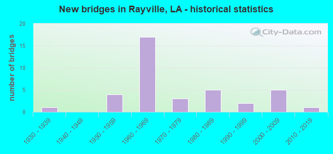
- New bridges - historical statistics
- 11930-1939
- 41950-1959
- 171960-1969
- 31970-1979
- 51980-1989
- 21990-1999
- 52000-2009
- 12010-2019


- Bridge Condition - Deck
- 23.3%Good
- 60.0%Satisfactory
- 10.0%Fair
- 6.7%Poor

- Bridge Condition - Superstructure
- 30.0%Good
- 56.7%Satisfactory
- 6.7%Fair
- 3.3%Poor
- 3.3%Serious

- Bridge Condition - Substructure
- 20.0%Good
- 50.0%Satisfactory
- 13.3%Fair
- 10.0%Poor
- 6.7%Serious

- Bridge Condition - Channel
- 20.6%Good
- 70.6%Satisfactory
- 5.9%Poor
- 2.9%Serious

- Bridge Condition - Culverts
- 12.5%Very good
- 12.5%Good
- 75.0%Satisfactory
Find on map >> Show street view
Structure Number: 54200000050202, Location: 1.5 MILES WEST OF US 425 (Lat: 32.459650, Lng: -91.774031), Route carried "on" structure: County highway , Year Built: 2011, Status: Open, Structure Length: 1.10m (3.61ft), Average Daily Traffic: 250 (year 2011), Average Future Daily Traffic: 150 (year 2036), Design Load: HS 20, Features Intersected: LITTLE CREEK, Facility Carried by Structure: GRIMSHAW ST
Minimum Vertical Clearance: 30+ m (98+ ft), Kilometerpoint: 0.000, Lanes on structure: 2, Owner: County Highway Agency, Approaching Roadway Width: 6.1m (20.0ft), Skew: 32 degrees, Material/Design: Concrete, Design/Construction: Culvert, Number Of Spans In Main Unit: 3, Length of Maximum Span: 3.0m (9.8ft)
Condition: Channel: Satisfactory, Culverts: Good, Operating Rating: 42.1 metric tons, Method Used To Determine Operating Rating: Load and Resistance Factor Rating (LRFR) rating reported by rating factor(RF) method using HL-93 loadings, Inventory Rating: 32.4 metric tons, Method Used To Determine Inventory Rating: Load and Resistance Factor Rating (LRFR) rating reported by rating factor(RF) method using HL-93 loadings, Structural Evaluation: Better than present minimum criteria, Waterway Adequacy: Equal to present desirable criteria, Approach Roadway Alignment: Equal to present desirable criteria, Designated Inspection Frequency: Every 24 months, Inspection Date: August 2021, Deck Structure Type: Concrete Cast-file-Place
Find on map >> Show street view
Structure Number: 54200020300001, Location: .4 MI EAST OF LA 133 (Lat: 32.481069, Lng: -91.798739), Route carried "on" structure: US 80, Year Built: 1958, Status: Posted for load, Structure Length: 11.58m (37.99ft), Average Daily Traffic: 3,100 (year 2016), Truck Traffic: 15%, Average Future Daily Traffic: 1,920 (year 2036), Design Load: HS 20, Features Intersected: BOEUF RIVER
Minimum Vertical Clearance: 30+ m (98+ ft), Kilometerpoint: 0.000, Lanes on structure: 2, Owner: State Highway Agency, Approaching Roadway Width: 12.2m (40.0ft), Material/Design: Steel, Design/Construction: Stringer/Multi-beam, Number Of Spans In Main Unit: 3, Number Of Approach Spans: 10, Length of Maximum Span: 18.3m (60.0ft), Curb-To-Curb Width: 8.5m (27.9ft), Out-to-Out Width: 10.2m (33.5ft)
Condition: Deck: Poor, Superstructure: Serious, Substructure: Serious, Channel: Satisfactory, Operating Rating: 23.3 metric tons, Method Used To Determine Operating Rating: Load and Resistance Factor Rating (LRFR) rating reported by rating factor(RF) method using HL-93 loadings, Inventory Rating: 18.1 metric tons, Method Used To Determine Inventory Rating: Load and Resistance Factor Rating (LRFR) rating reported by rating factor(RF) method using HL-93 loadings, Structural Evaluation: High priority of corrective action, Deck Geometry: Meets minimum limits, Waterway Adequacy: Equal to present desirable criteria, Approach Roadway Alignment: Equal to present desirable criteria, Bridge Posting: Required (Relationship of Operating Rating to Maximum Legal Load: 0.1 - 9.9% below), Length Of Structure Improvement: 12.50m (41.01ft), Designated Inspection Frequency: Every 24 months, Underwater Inspection Frequency: Every 60 months, Other Special Inspection Frequency: Every 12 months, Inspection Date: May 2021, Underwater Inspection Date: August 2020, Other Special Inspection Date: May 2020, Bridge Improvement Cost: $1,066,000, Total Project Cost: $1,599,000 ( Estimate for 2016), Deck Structure Type: Concrete Cast-file-Place, Wearing Surface/Protective System: Wearing Surface: Bituminous
Find on map >> Show street view
Structure Number: 54200020306081, Location: 3.0 MI EAST OF LA 852 (Lat: 32.473261, Lng: -91.700400), Route carried "on" structure: US 80, Year Built: 1953, Status: Open, Structure Length: 0.91m (2.99ft), Average Daily Traffic: 2,900 (year 2016), Truck Traffic: 15%, Average Future Daily Traffic: 1,980 (year 2036), Design Load: H 15, Features Intersected: BAYOU
Minimum Vertical Clearance: 30+ m (98+ ft), Kilometerpoint: 9.289, Lanes on structure: 2, Owner: State Highway Agency, Approaching Roadway Width: 7.3m (24.0ft), Skew: 20 degrees, Material/Design: Concrete, Design/Construction: Culvert, Number Of Spans In Main Unit: 5, Length of Maximum Span: 1.5m (4.9ft)
Condition: Channel: Satisfactory, Culverts: Satisfactory, Operating Rating: 42.8 metric tons, Method Used To Determine Operating Rating: Load and Resistance Factor Rating (LRFR) rating reported by rating factor(RF) method using HL-93 loadings, Inventory Rating: 33.0 metric tons, Method Used To Determine Inventory Rating: Load and Resistance Factor Rating (LRFR) rating reported by rating factor(RF) method using HL-93 loadings, Structural Evaluation: Equal to present minimum criteria, Waterway Adequacy: Better than present minimum criteria, Approach Roadway Alignment: Equal to present minimum criteria, Designated Inspection Frequency: Every 24 months, Inspection Date: August 2021, Deck Structure Type: Concrete Cast-file-Place
Find on map >> Show street view
Structure Number: 54200020306581, Location: .2 MI EAST OF LA 583 (Lat: 32.472639, Lng: -91.692400), Route carried "on" structure: US 80, Year Built: 1930, Status: Open, Structure Length: 2.19m (7.19ft), Average Daily Traffic: 2,600 (year 2016), Truck Traffic: 15%, Average Future Daily Traffic: 1,800 (year 2036), Design Load: H 15, Features Intersected: BEE BAYOU
Minimum Vertical Clearance: 30+ m (98+ ft), Kilometerpoint: 10.046, Lanes on structure: 2, Owner: State Highway Agency, Approaching Roadway Width: 9.8m (32.2ft), Skew: 4 degrees, Material/Design: Concrete, Design/Construction: Tee Beam, Number Of Spans In Main Unit: 2, Length of Maximum Span: 11.0m (36.1ft), Curb-To-Curb Width: 7.3m (24.0ft), Out-to-Out Width: 8.5m (27.9ft)
Condition: Deck: Satisfactory, Superstructure: Satisfactory, Substructure: Satisfactory, Channel: Satisfactory, Operating Rating: 45.4 metric tons, Method Used To Determine Operating Rating: Load Factor (LF), Inventory Rating: 27.2 metric tons, Method Used To Determine Inventory Rating: Load Factor (LF), Structural Evaluation: Equal to present minimum criteria, Deck Geometry: High priority of replacement, Waterway Adequacy: Better than present minimum criteria, Approach Roadway Alignment: Better than present minimum criteria, Length Of Structure Improvement: 2.96m (9.71ft), Designated Inspection Frequency: Every 24 months, Inspection Date: August 2021, Bridge Improvement Cost: $252,000, Total Project Cost: $378,000 ( Estimate for 2016), Deck Structure Type: Concrete Cast-file-Place, Wearing Surface/Protective System: Wearing Surface: Bituminous
Find on map >> Show street view
Structure Number: 54200710105331, Location: 1.4 MI NORTH OF LA 584 (Lat: 32.428531, Lng: -91.762200), Route carried "on" structure: State highway 137, Year Built: 1987, Status: Open, Structure Length: 3.05m (10.01ft), Average Daily Traffic: 4,800 (year 2016), Truck Traffic: 16%, Average Future Daily Traffic: 3,564 (year 2036), Design Load: HS 20, Features Intersected: CREEK
Minimum Vertical Clearance: 30+ m (98+ ft), Kilometerpoint: 8.496, Lanes on structure: 2, Base Highway Network: Yes (Inventory Route: 71-01-1, Subroute: 10), Owner: State Highway Agency, Approaching Roadway Width: 12.5m (41.0ft), Skew: 10 degrees, Material/Design: Concrete, Design/Construction: Slab, Number Of Spans In Main Unit: 5, Length of Maximum Span: 6.1m (20.0ft), Curb-To-Curb Width: 12.2m (40.0ft), Out-to-Out Width: 13.0m (42.7ft)
Condition: Deck: Good, Superstructure: Good, Substructure: Satisfactory, Channel: Good, Operating Rating: 68.0 metric tons, Method Used To Determine Operating Rating: Load Factor (LF), Inventory Rating: 40.8 metric tons, Method Used To Determine Inventory Rating: Load Factor (LF), Structural Evaluation: Equal to present minimum criteria, Deck Geometry: Better than present minimum criteria, Waterway Adequacy: Equal to present desirable criteria, Approach Roadway Alignment: Equal to present desirable criteria, Designated Inspection Frequency: Every 24 months, Inspection Date: July 2021, Deck Structure Type: Concrete Cast-file-Place, Wearing Surface/Protective System: Wearing Surface: Monolithic Concrete
Find on map >> Show street view
Structure Number: 54200710105332, Location: 1.4 MI NORTH OF LA 584 (Lat: 32.428789, Lng: -91.762400), Route carried "on" structure: State highway 137, Year Built: 1987, Status: Open, Structure Length: 3.05m (10.01ft), Average Daily Traffic: 4,800 (year 2016), Truck Traffic: 16%, Average Future Daily Traffic: 3,564 (year 2036), Design Load: HS 20, Features Intersected: DRY FORK CREEK
Minimum Vertical Clearance: 30+ m (98+ ft), Kilometerpoint: 5.472, Lanes on structure: 2, Base Highway Network: Yes (Inventory Route: 71-01-2, Subroute: 10), Owner: State Highway Agency, Approaching Roadway Width: 12.5m (41.0ft), Skew: 10 degrees, Material/Design: Concrete, Design/Construction: Slab, Number Of Spans In Main Unit: 5, Length of Maximum Span: 6.1m (20.0ft), Curb-To-Curb Width: 12.2m (40.0ft), Out-to-Out Width: 13.0m (42.7ft)
Condition: Deck: Satisfactory, Superstructure: Satisfactory, Substructure: Satisfactory, Channel: Good, Operating Rating: 68.0 metric tons, Method Used To Determine Operating Rating: Load Factor (LF), Inventory Rating: 40.8 metric tons, Method Used To Determine Inventory Rating: Load Factor (LF), Structural Evaluation: Equal to present minimum criteria, Deck Geometry: Better than present minimum criteria, Waterway Adequacy: Equal to present desirable criteria, Approach Roadway Alignment: Equal to present desirable criteria, Designated Inspection Frequency: Every 24 months, Inspection Date: July 2021, Deck Structure Type: Concrete Cast-file-Place, Wearing Surface/Protective System: Wearing Surface: Monolithic Concrete
Find on map >> Show street view
Structure Number: 54200710202201, Location: 2.2 MI NORTH OF US 80 (Lat: 32.508789, Lng: -91.757500), Route carried "on" structure: State highway 137, Year Built: 1971, Status: Open, Structure Length: 6.86m (22.51ft), Average Daily Traffic: 4,100 (year 2016), Truck Traffic: 16%, Average Future Daily Traffic: 2,220 (year 2036), Design Load: HS 20, Features Intersected: BOEUF RIVER
Minimum Vertical Clearance: 30+ m (98+ ft), Kilometerpoint: 3.479, Lanes on structure: 2, Base Highway Network: Yes (Inventory Route: 71-02-1, Subroute: 10), Owner: State Highway Agency, Approaching Roadway Width: 11.0m (36.1ft), Material/Design: Prestressed concrete, Design/Construction: Stringer/Multi-beam, Number Of Spans In Main Unit: 3, Length of Maximum Span: 22.9m (75.1ft), Curb-To-Curb Width: 9.1m (29.9ft), Out-to-Out Width: 10.4m (34.1ft)
Condition: Deck: Satisfactory, Superstructure: Good, Substructure: Satisfactory, Channel: Good, Operating Rating: 88.9 metric tons, Method Used To Determine Operating Rating: Load Factor (LF), Inventory Rating: 37.2 metric tons, Method Used To Determine Inventory Rating: Load Factor (LF), Structural Evaluation: Equal to present minimum criteria, Deck Geometry: Meets minimum limits, Waterway Adequacy: Better than present minimum criteria, Approach Roadway Alignment: Equal to present desirable criteria, Designated Inspection Frequency: Every 24 months, Inspection Date: July 2021, Deck Structure Type: Concrete Cast-file-Place, Wearing Surface/Protective System: Wearing Surface: Monolithic Concrete
Find on map >> Show street view
Structure Number: 54200710202651, Location: 2.6 MI NORTH OF US 80 (Lat: 32.515439, Lng: -91.757800), Route carried "on" structure: State highway 137, Year Built: 1971, Status: Open, Structure Length: 6.10m (20.01ft), Average Daily Traffic: 4,100 (year 2016), Truck Traffic: 16%, Average Future Daily Traffic: 2,220 (year 2036), Design Load: HS 20, Features Intersected: BEOUF CUT OFF
Minimum Vertical Clearance: 30+ m (98+ ft), Kilometerpoint: 4.216, Lanes on structure: 2, Base Highway Network: Yes (Inventory Route: 71-02-1, Subroute: 10), Owner: State Highway Agency, Approaching Roadway Width: 11.0m (36.1ft), Material/Design: Concrete, Design/Construction: Slab, Number Of Spans In Main Unit: 10, Length of Maximum Span: 6.1m (20.0ft), Curb-To-Curb Width: 9.1m (29.9ft), Out-to-Out Width: 10.4m (34.1ft)
Condition: Deck: Satisfactory, Superstructure: Satisfactory, Substructure: Fair, Channel: Satisfactory, Operating Rating: 66.2 metric tons, Method Used To Determine Operating Rating: Load Factor (LF), Inventory Rating: 39.9 metric tons, Method Used To Determine Inventory Rating: Load Factor (LF), Structural Evaluation: Somewhat better than minimum adequacy, Deck Geometry: Meets minimum limits, Waterway Adequacy: Better than present minimum criteria, Approach Roadway Alignment: Better than present minimum criteria, Designated Inspection Frequency: Every 24 months, Underwater Inspection Frequency: Every 60 months, Inspection Date: July 2021, Underwater Inspection Date: November 2020, Deck Structure Type: Concrete Cast-file-Place, Wearing Surface/Protective System: Wearing Surface: Monolithic Concrete
Find on map >> Show street view
Structure Number: 54201670408081, Location: .5 MI NORTH OF LA 132 (Lat: 32.449600, Lng: -91.784200), Route carried "on" structure: State highway 135, Year Built: 1962, Status: Posted for load, Structure Length: 2.38m (7.81ft), Average Daily Traffic: 1,240 (year 2016), Truck Traffic: 19%, Average Future Daily Traffic: 726 (year 2036), Design Load: H 15, Features Intersected: LITTLE CREEK
Minimum Vertical Clearance: 30+ m (98+ ft), Kilometerpoint: 12.862, Lanes on structure: 2, Owner: State Highway Agency, Approaching Roadway Width: 7.3m (24.0ft), Material/Design: Wood or Timber, Design/Construction: Stringer/Multi-beam, Number Of Spans In Main Unit: 4, Length of Maximum Span: 5.8m (19.0ft), Curb-To-Curb Width: 7.3m (24.0ft), Out-to-Out Width: 8.4m (27.6ft)
Condition: Deck: Satisfactory, Superstructure: Satisfactory, Substructure: Poor, Channel: Satisfactory, Operating Rating: 22.7 metric tons, Method Used To Determine Operating Rating: Allowable Stress (AS), Inventory Rating: 14.5 metric tons, Method Used To Determine Inventory Rating: Allowable Stress (AS), Structural Evaluation: Meets minimum limits, Deck Geometry: Meets minimum limits, Waterway Adequacy: Better than present minimum criteria, Approach Roadway Alignment: Better than present minimum criteria, Bridge Posting: Required (Relationship of Operating Rating to Maximum Legal Load: 10.0 - 19.9% below), Designated Inspection Frequency: Every 24 months, Other Special Inspection Frequency: Every 12 months, Inspection Date: September 2021, Other Special Inspection Date: September 2020, Deck Structure Type: Wood or Timber, Wearing Surface/Protective System: Wearing Surface: Bituminous
Find on map >> Show street view
Structure Number: 54203390301691, Location: 1.6 MI NORTH OF LA 584 (Lat: 32.423000, Lng: -91.718600), Route carried "on" structure: State highway 3048, Year Built: 1960, Status: Open, Structure Length: 1.19m (3.90ft), Average Daily Traffic: 1,080 (year 2016), Truck Traffic: 15%, Average Future Daily Traffic: 624 (year 2036), Design Load: H 15, Features Intersected: DRAIN
Minimum Vertical Clearance: 30+ m (98+ ft), Kilometerpoint: 2.652, Lanes on structure: 2, Owner: State Highway Agency, Approaching Roadway Width: 7.9m (25.9ft), Material/Design: Wood or Timber, Design/Construction: Stringer/Multi-beam, Number Of Spans In Main Unit: 2, Length of Maximum Span: 5.8m (19.0ft), Curb-To-Curb Width: 7.3m (24.0ft), Out-to-Out Width: 8.3m (27.2ft)
Condition: Deck: Satisfactory, Superstructure: Satisfactory, Substructure: Fair, Channel: Satisfactory, Operating Rating: 41.7 metric tons, Method Used To Determine Operating Rating: Allowable Stress (AS), Inventory Rating: 28.1 metric tons, Method Used To Determine Inventory Rating: Allowable Stress (AS), Structural Evaluation: Somewhat better than minimum adequacy, Deck Geometry: Meets minimum limits, Waterway Adequacy: Better than present minimum criteria, Approach Roadway Alignment: Better than present minimum criteria, Length Of Structure Improvement: 1.83m (6.00ft), Designated Inspection Frequency: Every 24 months, Inspection Date: September 2021, Bridge Improvement Cost: $156,000, Total Project Cost: $234,000 ( Estimate for 2016), Deck Structure Type: Wood or Timber, Wearing Surface/Protective System: Wearing Surface: Bituminous
Find on map >> Show street view
Structure Number: 54203390301991, Location: 2.0 MI NORTH OF LA 584 (Lat: 32.427089, Lng: -91.721400), Route carried "on" structure: State highway 3048, Year Built: 1960, Status: Posted for load, Structure Length: 4.11m (13.48ft), Average Daily Traffic: 1,080 (year 2016), Truck Traffic: 15%, Average Future Daily Traffic: 624 (year 2036), Design Load: H 15, Features Intersected: BEE BAYOU
Minimum Vertical Clearance: 30+ m (98+ ft), Kilometerpoint: 3.174, Lanes on structure: 2, Owner: State Highway Agency, Approaching Roadway Width: 7.9m (25.9ft), Material/Design: Wood or Timber, Design/Construction: Stringer/Multi-beam, Number Of Spans In Main Unit: 7, Length of Maximum Span: 5.8m (19.0ft), Curb-To-Curb Width: 7.6m (24.9ft), Out-to-Out Width: 8.4m (27.6ft)
Condition: Deck: Satisfactory, Superstructure: Satisfactory, Substructure: Fair, Channel: Satisfactory, Operating Rating: 11.8 metric tons, Method Used To Determine Operating Rating: Allowable Stress (AS), Inventory Rating: 7.3 metric tons, Method Used To Determine Inventory Rating: Allowable Stress (AS), Structural Evaluation: High priority of corrective action, Deck Geometry: Meets minimum limits, Waterway Adequacy: Better than present minimum criteria, Approach Roadway Alignment: Better than present minimum criteria, Bridge Posting: Required (Relationship of Operating Rating to Maximum Legal Load: 30.0 - 39.9% below), Designated Inspection Frequency: Every 24 months, Other Special Inspection Frequency: Every 12 months, Inspection Date: September 2021, Deck Structure Type: Wood or Timber, Wearing Surface/Protective System: Wearing Surface: Bituminous
Find on map >> Show street view
Structure Number: 54203390302381, Location: 2.4 MI NORTH OF LA 584 (Lat: 32.431789, Lng: -91.724700), Route carried "on" structure: State highway 3048, Year Built: 1960, Status: Open, Structure Length: 3.47m (11.38ft), Average Daily Traffic: 1,080 (year 2016), Truck Traffic: 15%, Average Future Daily Traffic: 624 (year 2036), Design Load: H 15, Features Intersected: BURNS BAYOU
Minimum Vertical Clearance: 30+ m (98+ ft), Kilometerpoint: 3.800, Lanes on structure: 2, Owner: State Highway Agency, Approaching Roadway Width: 7.9m (25.9ft), Material/Design: Wood or Timber, Design/Construction: Stringer/Multi-beam, Number Of Spans In Main Unit: 6, Length of Maximum Span: 5.8m (19.0ft), Curb-To-Curb Width: 7.6m (24.9ft), Out-to-Out Width: 8.5m (27.9ft)
Condition: Deck: Satisfactory, Superstructure: Satisfactory, Substructure: Fair, Channel: Satisfactory, Operating Rating: 27.2 metric tons, Method Used To Determine Operating Rating: Allowable Stress (AS), Inventory Rating: 19.0 metric tons, Method Used To Determine Inventory Rating: Allowable Stress (AS), Structural Evaluation: Somewhat better than minimum adequacy, Deck Geometry: Meets minimum limits, Waterway Adequacy: Better than present minimum criteria, Approach Roadway Alignment: Better than present minimum criteria, Length Of Structure Improvement: 4.36m (14.30ft), Designated Inspection Frequency: Every 24 months, Inspection Date: September 2021, Bridge Improvement Cost: $371,000, Total Project Cost: $556,000 ( Estimate for 2016), Deck Structure Type: Wood or Timber, Wearing Surface/Protective System: Wearing Surface: Bituminous
Find on map >> Show street view
Structure Number: 54203390304501, Location: LA 3048 OVER I-20 (Lat: 32.456139, Lng: -91.736100), Route carried "on" structure: State highway 3048, Year Built: 1969, Status: Open, Structure Length: 10.45m (34.28ft), Average Daily Traffic: 1,080 (year 2016), Truck Traffic: 15%, Average Future Daily Traffic: 624 (year 2036), Design Load: HS 20, Features Intersected: LA 3048 OVER I-20
Minimum Vertical Clearance: 30+ m (98+ ft), Kilometerpoint: 7.060, Lanes on structure: 2, Lanes under structure: 4, Owner: State Highway Agency, Approaching Roadway Width: 9.1m (29.9ft), Material/Design: Steel continuous, Design/Construction: Stringer/Multi-beam, Number Of Spans In Main Unit: 4, Length of Maximum Span: 30.5m (100.1ft), Curb-To-Curb Width: 8.5m (27.9ft), Out-to-Out Width: 9.5m (31.2ft)
Condition: Deck: Satisfactory, Superstructure: Satisfactory, Substructure: Good, Operating Rating: 39.0 metric tons, Method Used To Determine Operating Rating: Load Factor (LF), Inventory Rating: 23.6 metric tons, Method Used To Determine Inventory Rating: Load Factor (LF), Structural Evaluation: Equal to present minimum criteria, Deck Geometry: Somewhat better than minimum adequacy, Underclear: Better than present minimum criteria, Approach Roadway Alignment: Better than present minimum criteria, Designated Inspection Frequency: Every 24 months, Inspection Date: September 2021, Deck Structure Type: Concrete Cast-file-Place, Wearing Surface/Protective System: Wearing Surface: Monolithic Concrete
Find on map >> Show street view
Structure Number: 54203400101801, Location: 1.8 MI EAST OF US 425 (Lat: 32.405811, Lng: -91.736800), Route carried "on" structure: State highway 584, Year Built: 1954, Status: Open, Structure Length: 3.54m (11.61ft), Average Daily Traffic: 980 (year 2016), Truck Traffic: 19%, Average Future Daily Traffic: 432 (year 2036), Design Load: H 15, Features Intersected: BEE BAYOU
Minimum Vertical Clearance: 30+ m (98+ ft), Kilometerpoint: 2.886, Lanes on structure: 2, Owner: State Highway Agency, Approaching Roadway Width: 8.5m (27.9ft), Material/Design: Wood or Timber, Design/Construction: Stringer/Multi-beam, Number Of Spans In Main Unit: 6, Length of Maximum Span: 5.8m (19.0ft), Curb-To-Curb Width: 7.3m (24.0ft), Out-to-Out Width: 8.0m (26.2ft)
Condition: Deck: Fair, Superstructure: Satisfactory, Substructure: Satisfactory, Channel: Satisfactory, Operating Rating: 36.3 metric tons, Method Used To Determine Operating Rating: Allowable Stress (AS), Inventory Rating: 27.2 metric tons, Method Used To Determine Inventory Rating: Allowable Stress (AS), Structural Evaluation: Equal to present minimum criteria, Deck Geometry: Meets minimum limits, Waterway Adequacy: Meets minimum limits, Approach Roadway Alignment: Equal to present desirable criteria, Designated Inspection Frequency: Every 24 months, Inspection Date: September 2021, Deck Structure Type: Concrete Cast-file-Place, Wearing Surface/Protective System: Wearing Surface: Monolithic Concrete
Find on map >> Show street view
Structure Number: 54203400200001, Location: LA 583 OVER I-20 (Lat: 32.455981, Lng: -91.696219), Route carried "on" structure: State highway 583, Year Built: 1969, Status: Open, Structure Length: 7.38m (24.21ft), Average Daily Traffic: 1,570 (year 2016), Truck Traffic: 19%, Average Future Daily Traffic: 852 (year 2036), Design Load: HS 20, Features Intersected: LA 583 OVER I-20
Minimum Vertical Clearance: 30+ m (98+ ft), Kilometerpoint: 0.426, Lanes on structure: 2, Lanes under structure: 4, Owner: State Highway Agency, Approaching Roadway Width: 9.1m (29.9ft), Material/Design: Prestressed concrete, Design/Construction: Stringer/Multi-beam, Number Of Spans In Main Unit: 4, Length of Maximum Span: 21.3m (69.9ft), Curb-To-Curb Width: 7.3m (24.0ft), Out-to-Out Width: 9.0m (29.5ft)
Condition: Deck: Satisfactory, Superstructure: Satisfactory, Substructure: Satisfactory, Operating Rating: 66.2 metric tons, Method Used To Determine Operating Rating: Load Factor (LF), Inventory Rating: 29.9 metric tons, Method Used To Determine Inventory Rating: Load Factor (LF), Structural Evaluation: Equal to present minimum criteria, Deck Geometry: Meets minimum limits, Underclear: Better than present minimum criteria, Approach Roadway Alignment: Equal to present desirable criteria, Designated Inspection Frequency: Every 24 months, Inspection Date: September 2021, Deck Structure Type: Concrete Cast-file-Place, Wearing Surface/Protective System: Wearing Surface: Monolithic Concrete
Find on map >> Show street view
Structure Number: 54203400201301, Location: .1 MI SOUTH OF US 80 (Lat: 32.470611, Lng: -91.696100), Route carried "on" structure: State highway 583, Year Built: 1954, Status: Posted for load, Structure Length: 2.35m (7.71ft), Average Daily Traffic: 1,570 (year 2016), Truck Traffic: 19%, Average Future Daily Traffic: 852 (year 2036), Design Load: H 15, Features Intersected: BEE BAYOU
Minimum Vertical Clearance: 30+ m (98+ ft), Kilometerpoint: 2.052, Lanes on structure: 2, Owner: State Highway Agency, Approaching Roadway Width: 8.5m (27.9ft), Material/Design: Wood or Timber, Design/Construction: Stringer/Multi-beam, Number Of Spans In Main Unit: 4, Length of Maximum Span: 5.8m (19.0ft), Curb-To-Curb Width: 7.3m (24.0ft), Out-to-Out Width: 8.4m (27.6ft)
Condition: Deck: Poor, Superstructure: Poor, Substructure: Poor, Channel: Satisfactory, Operating Rating: 22.7 metric tons, Method Used To Determine Operating Rating: Allowable Stress (AS), Inventory Rating: 14.5 metric tons, Method Used To Determine Inventory Rating: Allowable Stress (AS), Structural Evaluation: Meets minimum limits, Deck Geometry: Meets minimum limits, Waterway Adequacy: Equal to present desirable criteria, Approach Roadway Alignment: Better than present minimum criteria, Bridge Posting: Required (Relationship of Operating Rating to Maximum Legal Load: 0.1 - 9.9% below), Length Of Structure Improvement: 3.11m (10.20ft), Designated Inspection Frequency: Every 24 months, Other Special Inspection Frequency: Every 12 months, Inspection Date: September 2021, Other Special Inspection Date: November 2020, Bridge Improvement Cost: $265,000, Total Project Cost: $397,000 ( Estimate for 2016), Deck Structure Type: Wood or Timber, Wearing Surface/Protective System: Wearing Surface: Bituminous
Find on map >> Show street view
Structure Number: 54204510707361, Location: 3.0 MI EAST OF LA 133 (Lat: 32.468269, Lng: -91.811900), Route carried "on" structure: Interstate 20, Year Built: 1968, Status: Open, Structure Length: 9.21m (30.22ft), Average Daily Traffic: 16,500 (year 2016), Truck Traffic: 37%, Average Future Daily Traffic: 10,836 (year 2036), Design Load: HS 20, Features Intersected: BOEUF RIVER
Minimum Vertical Clearance: 30+ m (98+ ft), Kilometerpoint: 11.689, Lanes on structure: 2, Base Highway Network: Yes (Inventory Route: 451-07-1, Subroute: 10), Owner: State Highway Agency, Approaching Roadway Width: 12.2m (40.0ft), Skew: 11 degrees, Material/Design: Prestressed concrete, Design/Construction: Stringer/Multi-beam, Number Of Spans In Main Unit: 5, Length of Maximum Span: 18.3m (60.0ft), Curb-To-Curb Width: 8.5m (27.9ft), Out-to-Out Width: 10.2m (33.5ft)
Condition: Deck: Good, Superstructure: Satisfactory, Substructure: Satisfactory, Channel: Good, Operating Rating: 77.1 metric tons, Method Used To Determine Operating Rating: Load Factor (LF), Inventory Rating: 35.4 metric tons, Method Used To Determine Inventory Rating: Load Factor (LF), Structural Evaluation: Equal to present minimum criteria, Deck Geometry: High priority of corrective action, Waterway Adequacy: Better than present minimum criteria, Approach Roadway Alignment: Better than present minimum criteria, Length Of Structure Improvement: 10.12m (33.20ft), Designated Inspection Frequency: Every 24 months, Inspection Date: October 2021, Bridge Improvement Cost: $863,000, Total Project Cost: $1,294,000 ( Estimate for 2016), Deck Structure Type: Concrete Cast-file-Place, Wearing Surface/Protective System: Wearing Surface: Monolithic Concrete
Find on map >> Show street view
Structure Number: 54204510707362, Location: 3.0 MI EAST OF LA 133 (Lat: 32.468339, Lng: -91.810800), Route carried "on" structure: Interstate 20, Year Built: 2008, Status: Open, Structure Length: 9.21m (30.22ft), Average Daily Traffic: 33,000 (year 2016), Truck Traffic: 37%, Average Future Daily Traffic: 10,836 (year 2036), Design Load: HS 20, Features Intersected: BOEUF RIVER
Minimum Vertical Clearance: 30+ m (98+ ft), Kilometerpoint: 32.148, Lanes on structure: 2, Base Highway Network: Yes (Inventory Route: 451-07-2, Subroute: 10), Owner: State Highway Agency, Approaching Roadway Width: 12.2m (40.0ft), Skew: 11 degrees, Material/Design: Concrete continuous, Design/Construction: Stringer/Multi-beam, Number Of Spans In Main Unit: 5, Length of Maximum Span: 18.3m (60.0ft), Curb-To-Curb Width: 12.2m (40.0ft), Out-to-Out Width: 12.5m (41.0ft)
Condition: Deck: Good, Superstructure: Good, Substructure: Good, Channel: Good, Operating Rating: 77.1 metric tons, Method Used To Determine Operating Rating: Load Factor (LF), Inventory Rating: 35.4 metric tons, Method Used To Determine Inventory Rating: Load Factor (LF), Structural Evaluation: Better than present minimum criteria, Deck Geometry: Somewhat better than minimum adequacy, Waterway Adequacy: Better than present minimum criteria, Approach Roadway Alignment: Better than present minimum criteria, Designated Inspection Frequency: Every 24 months, Inspection Date: October 2021, Deck Structure Type: Concrete Cast-file-Place, Wearing Surface/Protective System: Wearing Surface: Monolithic Concrete
Find on map >> Show street view
Structure Number: 54204510709611, Location: 5.3 MI EAST OF LA 133 (Lat: 32.459119, Lng: -91.774700), Route carried "on" structure: Interstate 20, Year Built: 1968, Status: Open, Structure Length: 1.04m (3.41ft), Average Daily Traffic: 33,000 (year 2016), Truck Traffic: 37%, Average Future Daily Traffic: 18,060 (year 2036), Design Load: HS 20, Features Intersected: DRAIN
Minimum Vertical Clearance: 30+ m (98+ ft), Kilometerpoint: 15.332, Lanes on structure: 4, Base Highway Network: Yes (Inventory Route: 451-07-1, Subroute: 10), Owner: State Highway Agency, Approaching Roadway Width: 12.8m (42.0ft), Skew: 11 degrees, Material/Design: Concrete, Design/Construction: Culvert, Number Of Spans In Main Unit: 3, Length of Maximum Span: 3.0m (9.8ft), Curb-To-Curb Width: 25.6m (84.0ft), Out-to-Out Width: 54.0m (177.2ft)
Condition: Channel: Satisfactory, Culverts: Satisfactory, Operating Rating: 42.1 metric tons, Method Used To Determine Operating Rating: Load and Resistance Factor Rating (LRFR) rating reported by rating factor(RF) method using HL-93 loadings, Inventory Rating: 32.4 metric tons, Method Used To Determine Inventory Rating: Load and Resistance Factor Rating (LRFR) rating reported by rating factor(RF) method using HL-93 loadings, Structural Evaluation: Equal to present minimum criteria, Deck Geometry: Superior to present desirable criteria, Waterway Adequacy: Equal to present desirable criteria, Approach Roadway Alignment: Equal to present desirable criteria, Designated Inspection Frequency: Every 24 months, Inspection Date: October 2021, Deck Structure Type: Concrete Cast-file-Place
Find on map >> Show street view
Structure Number: 54204510710511, Location: I-20 OVER LA 137 (Lat: 32.456850, Lng: -91.759300), Route carried "on" structure: Interstate 20, Year Built: 1968, Status: Open, Structure Length: 9.78m (32.09ft), Average Daily Traffic: 16,500 (year 2016), Truck Traffic: 37%, Average Future Daily Traffic: 10,836 (year 2036), Design Load: HS 20, Features Intersected: I-20 OVER US 425
Minimum Vertical Clearance: 30+ m (98+ ft), Kilometerpoint: 16.808, Lanes on structure: 2, Lanes under structure: 6, Base Highway Network: Yes (Inventory Route: 451-07-1, Subroute: 10), Owner: State Highway Agency, Approaching Roadway Width: 12.2m (40.0ft), Skew: 10 degrees, Material/Design: Prestressed concrete, Design/Construction: Stringer/Multi-beam, Number Of Spans In Main Unit: 5, Length of Maximum Span: 21.3m (69.9ft), Curb-To-Curb Width: 12.2m (40.0ft), Out-to-Out Width: 13.9m (45.6ft)
Condition: Deck: Satisfactory, Superstructure: Good, Substructure: Satisfactory, Operating Rating: 80.7 metric tons, Method Used To Determine Operating Rating: Load Factor (LF), Inventory Rating: 33.6 metric tons, Method Used To Determine Inventory Rating: Load Factor (LF), Structural Evaluation: Equal to present minimum criteria, Deck Geometry: Better than present minimum criteria, Underclear: Better than present minimum criteria, Approach Roadway Alignment: Equal to present desirable criteria, Designated Inspection Frequency: Every 24 months, Inspection Date: October 2021, Deck Structure Type: Concrete Cast-file-Place, Wearing Surface/Protective System: Wearing Surface: Monolithic Concrete
Find on map >> Show street view
Structure Number: 54204510710512, Location: I-20 OVER LA 137 (Lat: 32.456989, Lng: -91.758200), Route carried "on" structure: Interstate 20, Year Built: 1968, Status: Open, Structure Length: 9.78m (32.09ft), Average Daily Traffic: 16,500 (year 2016), Truck Traffic: 37%, Average Future Daily Traffic: 10,836 (year 2036), Design Load: HS 20, Features Intersected: I-20 OVER US 425
Minimum Vertical Clearance: 30+ m (98+ ft), Kilometerpoint: 27.031, Lanes on structure: 2, Lanes under structure: 6, Base Highway Network: Yes (Inventory Route: 451-07-2, Subroute: 10), Owner: State Highway Agency, Approaching Roadway Width: 12.2m (40.0ft), Skew: 10 degrees, Material/Design: Prestressed concrete, Design/Construction: Stringer/Multi-beam, Number Of Spans In Main Unit: 5, Length of Maximum Span: 21.3m (69.9ft), Curb-To-Curb Width: 12.2m (40.0ft), Out-to-Out Width: 13.0m (42.7ft)
Condition: Deck: Satisfactory, Superstructure: Good, Substructure: Satisfactory, Operating Rating: 80.7 metric tons, Method Used To Determine Operating Rating: Load Factor (LF), Inventory Rating: 33.6 metric tons, Method Used To Determine Inventory Rating: Load Factor (LF), Structural Evaluation: Equal to present minimum criteria, Deck Geometry: Better than present minimum criteria, Underclear: Better than present minimum criteria, Approach Roadway Alignment: Equal to present desirable criteria, Designated Inspection Frequency: Every 24 months, Inspection Date: October 2021, Deck Structure Type: Concrete Cast-file-Place, Wearing Surface/Protective System: Wearing Surface: Monolithic Concrete
Find on map >> Show street view
Structure Number: 54204510712031, Location: 1.5 MI EAST OF LA 137 (Lat: 32.456361, Lng: -91.733100), Route carried "on" structure: Interstate 20, Year Built: 1969, Status: Open, Structure Length: 1.01m (3.31ft), Average Daily Traffic: 30,900 (year 2016), Truck Traffic: 37%, Average Future Daily Traffic: 16,680 (year 2036), Design Load: HS 20, Features Intersected: BURNS BAYOU
Minimum Vertical Clearance: 30+ m (98+ ft), Kilometerpoint: 19.270, Lanes on structure: 4, Base Highway Network: Yes (Inventory Route: 451-07-1, Subroute: 10), Owner: State Highway Agency, Approaching Roadway Width: 12.8m (42.0ft), Skew: 14 degrees, Material/Design: Concrete, Design/Construction: Culvert, Number Of Spans In Main Unit: 3, Length of Maximum Span: 2.1m (6.9ft), Curb-To-Curb Width: 25.6m (84.0ft), Out-to-Out Width: 59.3m (194.6ft)
Condition: Channel: Satisfactory, Culverts: Satisfactory, Operating Rating: 42.1 metric tons, Method Used To Determine Operating Rating: Load and Resistance Factor Rating (LRFR) rating reported by rating factor(RF) method using HL-93 loadings, Inventory Rating: 32.4 metric tons, Method Used To Determine Inventory Rating: Load and Resistance Factor Rating (LRFR) rating reported by rating factor(RF) method using HL-93 loadings, Structural Evaluation: Equal to present minimum criteria, Deck Geometry: Superior to present desirable criteria, Waterway Adequacy: Equal to present desirable criteria, Approach Roadway Alignment: Equal to present desirable criteria, Designated Inspection Frequency: Every 24 months, Inspection Date: October 2021, Deck Structure Type: Concrete Cast-file-Place
Find on map >> Show street view
Structure Number: 54204510712721, Location: 2.2 MI EAST OF LA 137 (Lat: 32.456311, Lng: -91.721700), Route carried "on" structure: Interstate 20, Year Built: 1969, Status: Open, Structure Length: 1.22m (4.00ft), Average Daily Traffic: 30,900 (year 2016), Truck Traffic: 37%, Average Future Daily Traffic: 16,680 (year 2036), Design Load: HS 20, Features Intersected: DRAIN
Minimum Vertical Clearance: 30+ m (98+ ft), Kilometerpoint: 20.344, Lanes on structure: 4, Base Highway Network: Yes (Inventory Route: 451-07-1, Subroute: 10), Owner: State Highway Agency, Approaching Roadway Width: 12.8m (42.0ft), Skew: 34 degrees, Material/Design: Concrete, Design/Construction: Culvert, Number Of Spans In Main Unit: 3, Length of Maximum Span: 2.7m (8.9ft), Curb-To-Curb Width: 25.6m (84.0ft), Out-to-Out Width: 49.1m (161.1ft)
Condition: Channel: Good, Culverts: Satisfactory, Operating Rating: 42.1 metric tons, Method Used To Determine Operating Rating: Load and Resistance Factor Rating (LRFR) rating reported by rating factor(RF) method using HL-93 loadings, Inventory Rating: 32.4 metric tons, Method Used To Determine Inventory Rating: Load and Resistance Factor Rating (LRFR) rating reported by rating factor(RF) method using HL-93 loadings, Structural Evaluation: Equal to present minimum criteria, Deck Geometry: Superior to present desirable criteria, Waterway Adequacy: Equal to present desirable criteria, Approach Roadway Alignment: Equal to present desirable criteria, Designated Inspection Frequency: Every 24 months, Inspection Date: October 2021, Deck Structure Type: Concrete Cast-file-Place
Find on map >> Show street view
Structure Number: 54204510713631, Location: 3.1 MI EAST OF LA 137 (Lat: 32.456239, Lng: -91.705900), Route carried "on" structure: Interstate 20, Year Built: 1969, Status: Open, Structure Length: 4.57m (14.99ft), Average Daily Traffic: 15,450 (year 2016), Truck Traffic: 37%, Average Future Daily Traffic: 10,008 (year 2036), Design Load: HS 20, Features Intersected: BEE BAYOU
Minimum Vertical Clearance: 30+ m (98+ ft), Kilometerpoint: 21.831, Lanes on structure: 2, Base Highway Network: Yes (Inventory Route: 451-07-1, Subroute: 10), Owner: State Highway Agency, Approaching Roadway Width: 12.2m (40.0ft), Skew: 10 degrees, Material/Design: Concrete, Design/Construction: Slab, Number Of Spans In Main Unit: 6, Length of Maximum Span: 7.6m (24.9ft), Curb-To-Curb Width: 12.2m (40.0ft), Out-to-Out Width: 12.9m (42.3ft)
Condition: Deck: Satisfactory, Superstructure: Satisfactory, Substructure: Satisfactory, Channel: Satisfactory, Operating Rating: 73.5 metric tons, Method Used To Determine Operating Rating: Load Factor (LF), Inventory Rating: 44.4 metric tons, Method Used To Determine Inventory Rating: Load Factor (LF), Structural Evaluation: Equal to present minimum criteria, Deck Geometry: Better than present minimum criteria, Waterway Adequacy: Equal to present desirable criteria, Approach Roadway Alignment: Equal to present desirable criteria, Designated Inspection Frequency: Every 24 months, Inspection Date: October 2021, Deck Structure Type: Concrete Cast-file-Place, Wearing Surface/Protective System: Wearing Surface: Monolithic Concrete
Find on map >> Show street view
Structure Number: 54204510713632, Location: 3.1 MI EAST OF LA 137 (Lat: 32.456481, Lng: -91.705400), Route carried "on" structure: Interstate 20, Year Built: 1969, Status: Open, Structure Length: 4.57m (14.99ft), Average Daily Traffic: 15,450 (year 2016), Truck Traffic: 37%, Average Future Daily Traffic: 10,008 (year 2036), Design Load: HS 20, Features Intersected: BEE BAYOU
Minimum Vertical Clearance: 30+ m (98+ ft), Kilometerpoint: 22.061, Lanes on structure: 2, Base Highway Network: Yes (Inventory Route: 451-07-2, Subroute: 10), Owner: State Highway Agency, Approaching Roadway Width: 12.2m (40.0ft), Skew: 10 degrees, Material/Design: Concrete, Design/Construction: Slab, Number Of Spans In Main Unit: 6, Length of Maximum Span: 7.6m (24.9ft), Curb-To-Curb Width: 12.2m (40.0ft), Out-to-Out Width: 12.9m (42.3ft)
Condition: Deck: Satisfactory, Superstructure: Satisfactory, Substructure: Satisfactory, Channel: Satisfactory, Operating Rating: 73.5 metric tons, Method Used To Determine Operating Rating: Load Factor (LF), Inventory Rating: 44.4 metric tons, Method Used To Determine Inventory Rating: Load Factor (LF), Structural Evaluation: Equal to present minimum criteria, Deck Geometry: Better than present minimum criteria, Waterway Adequacy: Better than present minimum criteria, Approach Roadway Alignment: Better than present minimum criteria, Designated Inspection Frequency: Every 24 months, Inspection Date: October 2021, Deck Structure Type: Concrete Cast-file-Place, Wearing Surface/Protective System: Wearing Surface: Monolithic Concrete
Find on map >> Show street view
Structure Number: 54204510714501, Location: .3 MI EAST OF LA 583 (Lat: 32.456169, Lng: -91.691000), Route carried "on" structure: Interstate 20, Year Built: 1969, Status: Open, Structure Length: 0.79m (2.59ft), Average Daily Traffic: 30,100 (year 2016), Truck Traffic: 37%, Average Future Daily Traffic: 16,380 (year 2036), Design Load: HS 20, Features Intersected: COW BAYOU
Minimum Vertical Clearance: 30+ m (98+ ft), Kilometerpoint: 23.231, Lanes on structure: 4, Base Highway Network: Yes (Inventory Route: 451-07-1, Subroute: 10), Owner: State Highway Agency, Approaching Roadway Width: 12.8m (42.0ft), Skew: 10 degrees, Material/Design: Concrete, Design/Construction: Culvert, Number Of Spans In Main Unit: 3, Length of Maximum Span: 2.4m (7.9ft)
Condition: Channel: Satisfactory, Culverts: Satisfactory, Operating Rating: 42.1 metric tons, Method Used To Determine Operating Rating: Load and Resistance Factor Rating (LRFR) rating reported by rating factor(RF) method using HL-93 loadings, Inventory Rating: 32.4 metric tons, Method Used To Determine Inventory Rating: Load and Resistance Factor Rating (LRFR) rating reported by rating factor(RF) method using HL-93 loadings, Structural Evaluation: Equal to present minimum criteria, Waterway Adequacy: Equal to present desirable criteria, Approach Roadway Alignment: Equal to present desirable criteria, Designated Inspection Frequency: Every 24 months, Inspection Date: October 2021, Deck Structure Type: Concrete Cast-file-Place
Find on map >> Show street view
Structure Number: 54208420703701, Location: 3.7 MI EAST OF LA 135 (Lat: 32.405800, Lng: -91.770400), Route carried "on" structure: State highway 584, Year Built: 1979, Status: Open, Structure Length: 2.32m (7.61ft), Average Daily Traffic: 370 (year 2016), Truck Traffic: 19%, Average Future Daily Traffic: 216 (year 2036), Design Load: HS 20, Features Intersected: DRAINAGE CANAL
Minimum Vertical Clearance: 30+ m (98+ ft), Kilometerpoint: 5.956, Lanes on structure: 2, Owner: State Highway Agency, Approaching Roadway Width: 11.0m (36.1ft), Material/Design: Concrete, Design/Construction: Slab, Number Of Spans In Main Unit: 4, Length of Maximum Span: 5.8m (19.0ft), Curb-To-Curb Width: 9.8m (32.2ft), Out-to-Out Width: 10.7m (35.1ft)
Condition: Deck: Satisfactory, Superstructure: Satisfactory, Substructure: Satisfactory, Channel: Satisfactory, Operating Rating: 65.3 metric tons, Method Used To Determine Operating Rating: Load Factor (LF), Inventory Rating: 39.0 metric tons, Method Used To Determine Inventory Rating: Load Factor (LF), Structural Evaluation: Equal to present minimum criteria, Deck Geometry: Better than present minimum criteria, Waterway Adequacy: Better than present minimum criteria, Approach Roadway Alignment: Equal to present desirable criteria, Designated Inspection Frequency: Every 24 months, Inspection Date: September 2021, Deck Structure Type: Concrete Precast Panels, Wearing Surface/Protective System: Wearing Surface: Monolithic Concrete
Find on map >> Show street view
Structure Number: 54232203914401, Location: LOGMI 0.01 FR 0DE TO (Lat: 32.337211, Lng: -91.731881), Route carried "on" structure: County highway , Year Built: 1966, Status: Posted for load, Structure Length: 1.74m (5.71ft), Average Daily Traffic: 230 (year 1974), Average Future Daily Traffic: 138 (year 2036), Design Load: HS 20, Features Intersected: CREEK, Facility Carried by Structure: HALES RD
Minimum Vertical Clearance: 30+ m (98+ ft), Kilometerpoint: 0.000, Lanes on structure: 2, Owner: County Highway Agency, Approaching Roadway Width: 8.5m (27.9ft), Material/Design: Concrete, Design/Construction: Slab, Number Of Spans In Main Unit: 3, Length of Maximum Span: 5.8m (19.0ft), Curb-To-Curb Width: 7.3m (24.0ft), Out-to-Out Width: 8.4m (27.6ft)
Condition: Deck: Fair, Superstructure: Fair, Substructure: Poor, Channel: Satisfactory, Operating Rating: 14.3 metric tons, Method Used To Determine Operating Rating: Load and Resistance Factor Rating (LRFR) rating reported by rating factor(RF) method using HL-93 loadings, Inventory Rating: 11.0 metric tons, Method Used To Determine Inventory Rating: Load and Resistance Factor Rating (LRFR) rating reported by rating factor(RF) method using HL-93 loadings, Structural Evaluation: Meets minimum limits, Deck Geometry: Somewhat better than minimum adequacy, Waterway Adequacy: Better than present minimum criteria, Approach Roadway Alignment: Equal to present desirable criteria, Bridge Posting: Required (Relationship of Operating Rating to Maximum Legal Load: 30.0 - 39.9% below), Length Of Structure Improvement: 2.44m (8.01ft), Designated Inspection Frequency: Every 24 months, Other Special Inspection Frequency: Every 12 months, Inspection Date: August 2021, Other Special Inspection Date: August 2020, Bridge Improvement Cost: $145,000, Total Project Cost: $217,000 ( Estimate for 2016), Deck Structure Type: Concrete Precast Panels
Find on map >> Show street view
Structure Number: 54232246914381, Location: LOGMI 5.05 FR 0DE TO (Lat: 32.409839, Lng: -91.730939), Route carried "on" structure: County highway , Year Built: 1966, Status: Posted for load, Structure Length: 2.32m (7.61ft), Average Daily Traffic: 320 (year 1974), Average Future Daily Traffic: 192 (year 2036), Design Load: HS 20, Features Intersected: BEE BAYOU, Facility Carried by Structure: MCLEMORE RD
Minimum Vertical Clearance: 30+ m (98+ ft), Kilometerpoint: 0.000, Lanes on structure: 2, Owner: County Highway Agency, Approaching Roadway Width: 7.3m (24.0ft), Material/Design: Concrete, Design/Construction: Slab, Number Of Spans In Main Unit: 4, Length of Maximum Span: 5.8m (19.0ft), Curb-To-Curb Width: 7.4m (24.3ft), Out-to-Out Width: 8.3m (27.2ft)
Condition: Deck: Fair, Superstructure: Fair, Substructure: Serious, Channel: Serious, Operating Rating: 22.4 metric tons, Method Used To Determine Operating Rating: Load and Resistance Factor Rating (LRFR) rating reported by rating factor(RF) method using HL-93 loadings, Inventory Rating: 17.2 metric tons, Method Used To Determine Inventory Rating: Load and Resistance Factor Rating (LRFR) rating reported by rating factor(RF) method using HL-93 loadings, Structural Evaluation: High priority of corrective action, Deck Geometry: Somewhat better than minimum adequacy, Waterway Adequacy: Equal to present desirable criteria, Approach Roadway Alignment: Equal to present desirable criteria, Bridge Posting: Required (Relationship of Operating Rating to Maximum Legal Load: 20.0 - 29.9% below), Length Of Structure Improvement: 6.07m (19.91ft), Designated Inspection Frequency: Every 24 months, Other Special Inspection Frequency: Every 12 months, Inspection Date: June 2021, Other Special Inspection Date: June 2020, Bridge Improvement Cost: $362,000, Total Project Cost: $543,000 ( Estimate for 2016), Deck Structure Type: Concrete Cast-file-Place, Wearing Surface/Protective System: Wearing Surface: Bituminous
Find on map >> Show street view
Structure Number: 54232252914731, Location: 1.1 MI N of LA 584 (Lat: 32.420650, Lng: -91.790069), Route carried "on" structure: County highway , Year Built: 2005, Status: Open, Structure Length: 2.41m (7.91ft), Average Daily Traffic: 400 (year 2016), Average Future Daily Traffic: 240 (year 2036), Design Load: HS 20, Features Intersected: DRY FORK CUT-OFF, Facility Carried by Structure: BAREFIELD RD
Minimum Vertical Clearance: 30+ m (98+ ft), Kilometerpoint: 0.000, Lanes on structure: 2, Base Highway Network: Yes, Owner: County Highway Agency, Approaching Roadway Width: 7.9m (25.9ft), Material/Design: Concrete, Design/Construction: Slab, Number Of Spans In Main Unit: 4, Length of Maximum Span: 6.1m (20.0ft), Curb-To-Curb Width: 7.3m (24.0ft), Out-to-Out Width: 8.1m (26.6ft)
Condition: Deck: Good, Superstructure: Good, Substructure: Good, Channel: Satisfactory, Operating Rating: 64.4 metric tons, Method Used To Determine Operating Rating: Load Factor (LF), Inventory Rating: 38.1 metric tons, Method Used To Determine Inventory Rating: Load Factor (LF), Structural Evaluation: Better than present minimum criteria, Deck Geometry: Somewhat better than minimum adequacy, Waterway Adequacy: Equal to present desirable criteria, Approach Roadway Alignment: Equal to present desirable criteria, Designated Inspection Frequency: Every 24 months, Inspection Date: June 2021, Deck Structure Type: Concrete Cast-file-Place
Find on map >> Show street view
Structure Number: 54232259914341, Location: 0.2 MI E of LA 3048 (Lat: 32.434889, Lng: -91.723661), Route carried "on" structure: County highway , Year Built: 2003, Status: Open, Structure Length: 3.05m (10.01ft), Average Daily Traffic: 300 (year 2001), Average Future Daily Traffic: 180 (year 2036), Design Load: HS 20, Features Intersected: BURNS BAYOU, Facility Carried by Structure: PONY GREER RD
Minimum Vertical Clearance: 30+ m (98+ ft), Kilometerpoint: 0.000, Lanes on structure: 2, Base Highway Network: Yes, Owner: County Highway Agency, Approaching Roadway Width: 8.2m (26.9ft), Material/Design: Concrete, Design/Construction: Slab, Number Of Spans In Main Unit: 5, Length of Maximum Span: 6.1m (20.0ft), Curb-To-Curb Width: 7.1m (23.3ft), Out-to-Out Width: 7.5m (24.6ft)
Condition: Deck: Good, Superstructure: Good, Substructure: Good, Channel: Satisfactory, Operating Rating: 43.1 metric tons, Method Used To Determine Operating Rating: Load and Resistance Factor Rating (LRFR) rating reported by rating factor(RF) method using HL-93 loadings, Inventory Rating: 33.4 metric tons, Method Used To Determine Inventory Rating: Load and Resistance Factor Rating (LRFR) rating reported by rating factor(RF) method using HL-93 loadings, Structural Evaluation: Better than present minimum criteria, Deck Geometry: Meets minimum limits, Waterway Adequacy: Equal to present desirable criteria, Approach Roadway Alignment: Equal to present desirable criteria, Designated Inspection Frequency: Every 24 months, Underwater Inspection Frequency: Every 60 months, Inspection Date: June 2021, Underwater Inspection Date: August 2020, Deck Structure Type: Concrete Cast-file-Place
Find on map >> Show street view
Structure Number: 54232261914301, Location: 0.5 MI E of LA 3048 (Lat: 32.434861, Lng: -91.718589), Route carried "on" structure: County highway , Year Built: 2005, Status: Open, Structure Length: 1.83m (6.00ft), Average Daily Traffic: 350 (year 2004), Average Future Daily Traffic: 210 (year 2036), Design Load: HS 20, Features Intersected: BEE BAYOU, Facility Carried by Structure: PONY GREER RD
Minimum Vertical Clearance: 30+ m (98+ ft), Kilometerpoint: 0.000, Lanes on structure: 2, Owner: County Highway Agency, Approaching Roadway Width: 5.8m (19.0ft), Material/Design: Concrete, Design/Construction: Slab, Number Of Spans In Main Unit: 3, Length of Maximum Span: 6.1m (20.0ft), Curb-To-Curb Width: 8.3m (27.2ft), Out-to-Out Width: 9.3m (30.5ft)
Condition: Deck: Good, Superstructure: Good, Substructure: Good, Channel: Good, Operating Rating: 65.3 metric tons, Method Used To Determine Operating Rating: Load Factor (LF), Inventory Rating: 39.0 metric tons, Method Used To Determine Inventory Rating: Load Factor (LF), Structural Evaluation: Better than present minimum criteria, Deck Geometry: Somewhat better than minimum adequacy, Waterway Adequacy: Equal to present desirable criteria, Approach Roadway Alignment: Equal to present desirable criteria, Length Of Structure Improvement: 2.56m (8.40ft), Designated Inspection Frequency: Every 24 months, Inspection Date: June 2021, Bridge Improvement Cost: $152,000, Total Project Cost: $228,000 ( Estimate for 2016), Deck Structure Type: Concrete Cast-file-Place, Wearing Surface/Protective System: Wearing Surface: Monolithic Concrete
Find on map >> Show street view
Structure Number: 54232279914581, Location: 0.4 MI W of US 425 (Lat: 32.467911, Lng: -91.765931), Route carried "on" structure: County highway , Year Built: 1991, Status: Open, Structure Length: 2.32m (7.61ft), Average Daily Traffic: 570 (year 1979), Average Future Daily Traffic: 342 (year 2036), Design Load: HS 20, Features Intersected: LITTLE CREEK, Facility Carried by Structure: FRAGALA ST
Minimum Vertical Clearance: 30+ m (98+ ft), Kilometerpoint: 0.000, Lanes on structure: 2, Owner: County Highway Agency, Approaching Roadway Width: 6.4m (21.0ft), Skew: 6 degrees, Material/Design: Concrete, Design/Construction: Slab, Number Of Spans In Main Unit: 4, Length of Maximum Span: 5.8m (19.0ft), Curb-To-Curb Width: 7.3m (24.0ft), Out-to-Out Width: 8.2m (26.9ft)
Condition: Deck: Satisfactory, Superstructure: Satisfactory, Substructure: Satisfactory, Channel: Satisfactory, Operating Rating: 36.9 metric tons, Method Used To Determine Operating Rating: Load and Resistance Factor Rating (LRFR) rating reported by rating factor(RF) method using HL-93 loadings, Inventory Rating: 28.5 metric tons, Method Used To Determine Inventory Rating: Load and Resistance Factor Rating (LRFR) rating reported by rating factor(RF) method using HL-93 loadings, Structural Evaluation: Equal to present minimum criteria, Deck Geometry: Meets minimum limits, Waterway Adequacy: Equal to present desirable criteria, Approach Roadway Alignment: Equal to present desirable criteria, Designated Inspection Frequency: Every 24 months, Inspection Date: June 2021, Deck Structure Type: Concrete Cast-file-Place
Find on map >> Show street view
Structure Number: 54232282914551, Location: 0.2 MI W of US 425 (Lat: 32.473519, Lng: -91.762169), Route carried "on" structure: County highway , Year Built: 1991, Status: Open, Structure Length: 0.91m (2.99ft), Average Daily Traffic: 250 (year 1979), Average Future Daily Traffic: 150 (year 2036), Design Load: HS 20, Features Intersected: LITTLE CREEK, Facility Carried by Structure: FRANCIS ST
Minimum Vertical Clearance: 30+ m (98+ ft), Kilometerpoint: 0.000, Lanes on structure: 2, Owner: Town or Township Highway Agency, Approaching Roadway Width: 5.8m (19.0ft), Skew: 6 degrees, Material/Design: Steel, Design/Construction: Culvert, Number Of Spans In Main Unit: 3, Length of Maximum Span: 2.4m (7.9ft)
Condition: Channel: Poor, Culverts: Satisfactory, Operating Rating: 97.2 metric tons, Method Used To Determine Operating Rating: Load and Resistance Factor Rating (LRFR) rating reported by rating factor(RF) method using HL-93 loadings, Inventory Rating: 74.5 metric tons, Method Used To Determine Inventory Rating: Load and Resistance Factor Rating (LRFR) rating reported by rating factor(RF) method using HL-93 loadings, Structural Evaluation: Equal to present minimum criteria, Waterway Adequacy: Better than present minimum criteria, Approach Roadway Alignment: Equal to present desirable criteria, Designated Inspection Frequency: Every 24 months, Inspection Date: August 2021
Find on map >> Show street view
Structure Number: 54232283914551, Location: LOGMI 0.22 FR 1 TO 2 (Lat: 32.475281, Lng: -91.761019), Route carried "on" structure: County highway , Year Built: 1982, Status: Open, Structure Length: 1.16m (3.81ft), Average Daily Traffic: 250 (year 1980), Average Future Daily Traffic: 150 (year 2036), Design Load: HS 20, Features Intersected: LITTLE CREEK, Facility Carried by Structure: ACEL ST
Minimum Vertical Clearance: 30+ m (98+ ft), Kilometerpoint: 0.000, Lanes on structure: 2, Owner: Town or Township Highway Agency, Approaching Roadway Width: 6.7m (22.0ft), Material/Design: Concrete, Design/Construction: Slab, Number Of Spans In Main Unit: 2, Length of Maximum Span: 5.8m (19.0ft), Curb-To-Curb Width: 6.9m (22.6ft), Out-to-Out Width: 9.4m (30.8ft)
Condition: Deck: Good, Superstructure: Good, Substructure: Good, Channel: Satisfactory, Operating Rating: 36.9 metric tons, Method Used To Determine Operating Rating: Load and Resistance Factor Rating (LRFR) rating reported by rating factor(RF) method using HL-93 loadings, Inventory Rating: 28.5 metric tons, Method Used To Determine Inventory Rating: Load and Resistance Factor Rating (LRFR) rating reported by rating factor(RF) method using HL-93 loadings, Structural Evaluation: Better than present minimum criteria, Deck Geometry: Meets minimum limits, Waterway Adequacy: Equal to present minimum criteria, Approach Roadway Alignment: Equal to present desirable criteria, Designated Inspection Frequency: Every 24 months, Inspection Date: August 2021, Deck Structure Type: Concrete Cast-file-Place
Find on map >> Show street view
Structure Number: 54232284914551, Location: LOGMI 0.24 FR 4 TO 5 (Lat: 32.476439, Lng: -91.760531), Route carried "on" structure: County highway , Year Built: 1984, Status: Open, Structure Length: 1.74m (5.71ft), Average Daily Traffic: 250 (year 1974), Average Future Daily Traffic: 150 (year 2036), Design Load: HS 20, Features Intersected: LITTLE CREEK, Facility Carried by Structure: MADELINE ST
Minimum Vertical Clearance: 30+ m (98+ ft), Kilometerpoint: 0.000, Lanes on structure: 2, Owner: Town or Township Highway Agency, Approaching Roadway Width: 7.9m (25.9ft), Skew: 1 degrees, Material/Design: Concrete, Design/Construction: Slab, Number Of Spans In Main Unit: 3, Length of Maximum Span: 5.8m (19.0ft), Curb or Sidewalk Widths: Left: 1.2m (3.9ft), Right: 0.0m, Curb-To-Curb Width: 7.3m (24.0ft), Out-to-Out Width: 9.4m (30.8ft)
Condition: Deck: Satisfactory, Superstructure: Satisfactory, Substructure: Satisfactory, Channel: Poor, Operating Rating: 37.6 metric tons, Method Used To Determine Operating Rating: Load and Resistance Factor Rating (LRFR) rating reported by rating factor(RF) method using HL-93 loadings, Inventory Rating: 28.8 metric tons, Method Used To Determine Inventory Rating: Load and Resistance Factor Rating (LRFR) rating reported by rating factor(RF) method using HL-93 loadings, Structural Evaluation: Equal to present minimum criteria, Deck Geometry: Somewhat better than minimum adequacy, Waterway Adequacy: Equal to present minimum criteria, Approach Roadway Alignment: Equal to present desirable criteria, Designated Inspection Frequency: Every 24 months, Inspection Date: August 2021, Deck Structure Type: Concrete Cast-file-Place
Find on map >> Show street view
Structure Number: 54232305914311, Location: LOG MI 0.04 FR 485 TO 557 (Lat: 32.508150, Lng: -91.716719), Route carried "on" structure: County highway , Year Built: 1985, Status: Open, Structure Length: 9.05m (29.69ft), Average Daily Traffic: 208 (year 1979), Average Future Daily Traffic: 124 (year 2036), Design Load: HS 20, Features Intersected: BOEUF RIVER, Facility Carried by Structure: ADCOCK RD
Minimum Vertical Clearance: 30+ m (98+ ft), Kilometerpoint: 0.000, Lanes on structure: 2, Owner: County Highway Agency, Approaching Roadway Width: 7.3m (24.0ft), Material/Design: Prestressed concrete, Design/Construction: Stringer/Multi-beam, Number Of Spans In Main Unit: 6, Length of Maximum Span: 15.2m (49.9ft), Curb-To-Curb Width: 7.3m (24.0ft), Out-to-Out Width: 8.1m (26.6ft)
Condition: Deck: Satisfactory, Superstructure: Satisfactory, Substructure: Satisfactory, Channel: Satisfactory, Operating Rating: 65.1 metric tons, Method Used To Determine Operating Rating: Load and Resistance Factor Rating (LRFR) rating reported by rating factor(RF) method using HL-93 loadings, Inventory Rating: 46.7 metric tons, Method Used To Determine Inventory Rating: Load and Resistance Factor Rating (LRFR) rating reported by rating factor(RF) method using HL-93 loadings, Structural Evaluation: Equal to present minimum criteria, Deck Geometry: Somewhat better than minimum adequacy, Waterway Adequacy: Equal to present desirable criteria, Approach Roadway Alignment: High priority of corrective action, Designated Inspection Frequency: Every 24 months, Underwater Inspection Frequency: Every 60 months, Inspection Date: July 2021, Underwater Inspection Date: Febuary 2018, Deck Structure Type: Concrete Cast-file-Place
Find on map >> Show street view
Structure Number: 54232311914421, Location: 1.6 MI SE of US 425 (Lat: 32.517200, Lng: -91.734150), Route carried "on" structure: County highway , Year Built: 2005, Status: Open, Structure Length: 0.91m (2.99ft), Average Daily Traffic: 200 (year 2016), Average Future Daily Traffic: 120 (year 2036), Design Load: HS 20, Features Intersected: BALFOUR CREEK, Facility Carried by Structure: SCALES RD
Minimum Vertical Clearance: 30+ m (98+ ft), Kilometerpoint: 0.000, Lanes on structure: 2, Owner: County Highway Agency, Approaching Roadway Width: 5.5m (18.0ft), Material/Design: Concrete, Design/Construction: Culvert, Number Of Spans In Main Unit: 4, Length of Maximum Span: 2.1m (6.9ft)
Condition: Channel: Satisfactory, Culverts: Very good, Operating Rating: 42.1 metric tons, Method Used To Determine Operating Rating: Load and Resistance Factor Rating (LRFR) rating reported by rating factor(RF) method using HL-93 loadings, Inventory Rating: 32.4 metric tons, Method Used To Determine Inventory Rating: Load and Resistance Factor Rating (LRFR) rating reported by rating factor(RF) method using HL-93 loadings, Structural Evaluation: Equal to present desirable criteria, Waterway Adequacy: Equal to present minimum criteria, Approach Roadway Alignment: Equal to present minimum criteria, Designated Inspection Frequency: Every 24 months, Inspection Date: June 2021, Deck Structure Type: Concrete Cast-file-Place
Find on map >> Show street view
Structure Number: 54203390304501, Location: 1.27 MI E OF US 425 (Lat: 32.456369, Lng: -91.736450), Route carried "under" structure: Interstate 20, Structure Length: 0. m, Average Daily Traffic: 1,040 (year 2015), Features Intersected: LA 3048 OVER I-20
Minimum Vertical Clearance: 5.06m (16.60ft), Kilometerpoint: 18.955, Lanes on structure: 2, Length of Maximum Span: 0.0m
Find on map >> Show street view
Structure Number: 54203390304501, Location: 1.27 MI E OF US 425 (Lat: 32.456631, Lng: -91.736611), Route carried "under" structure: Interstate 20, Structure Length: 0. m, Average Daily Traffic: 1,040 (year 2015), Features Intersected: LA 3048 OVER I-20
Minimum Vertical Clearance: 5.00m (16.40ft), Kilometerpoint: 25.000, Lanes on structure: 2, Length of Maximum Span: 0.0m
Find on map >> Show street view
Structure Number: 54203400200001, Location: 4.0 MI W OF LA 183 (Lat: 32.456439, Lng: -91.696161), Route carried "under" structure: Interstate 20, Structure Length: 0. m, Average Daily Traffic: 1,420 (year 2015), Features Intersected: LA 583 OVER I-20
Minimum Vertical Clearance: 4.97m (16.31ft), Kilometerpoint: 21.195, Lanes on structure: 2, Length of Maximum Span: 0.0m
Find on map >> Show street view
Structure Number: 54203400200001, Location: 4.0 MI W OF LA 183 (Lat: 32.456189, Lng: -91.696281), Route carried "under" structure: Interstate 20, Structure Length: 0. m, Average Daily Traffic: 1,420 (year 2015), Features Intersected: LA 583 OVER I-20
Minimum Vertical Clearance: 4.97m (16.31ft), Kilometerpoint: 22.730, Lanes on structure: 2, Length of Maximum Span: 0.0m
Find on map >> Show street view
Structure Number: 54204510710511, Location: 6.0 MI E OF LA 133 (Lat: 32.456869, Lng: -91.758969), Route carried "under" structure: Interstate 20, Structure Length: 0. m, Average Daily Traffic: 18,060 (year 2015), Features Intersected: I-20 EB OVER US 425 S
Minimum Vertical Clearance: 6.77m (22.21ft), Kilometerpoint: 2.340, Lanes on structure: 2, Length of Maximum Span: 0.0m
Find on map >> Show street view
Structure Number: 54204510710511, Location: 6.0 MI E OF LA 133 (Lat: 32.456719, Lng: -91.758831), Route carried "under" structure: Interstate 20, Structure Length: 0. m, Average Daily Traffic: 18,060 (year 2015), Features Intersected: I-20 EB OVER US 425 N
Minimum Vertical Clearance: 6.83m (22.41ft), Kilometerpoint: 11.639, Lanes on structure: 2, Length of Maximum Span: 0.0m
Find on map >> Show street view
Structure Number: 54204510710512, Location: 6.0 MI E OF LA 133 (Lat: 32.456969, Lng: -91.758550), Route carried "under" structure: Interstate 20, Structure Length: 0. m, Average Daily Traffic: 18,060 (year 2015), Features Intersected: I-20 WB OVER US 425 N
Minimum Vertical Clearance: 6.83m (22.41ft), Kilometerpoint: 0.085, Lanes on structure: 2, Length of Maximum Span: 0.0m