Bridge Statistics for Princeton, West Virginia (WV)
Condition, Traffic, Stress, Structural Evaluation, Project Costs
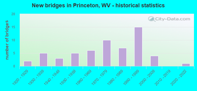
- New bridges - historical statistics
- 21920-1929
- 51930-1939
- 31940-1949
- 51950-1959
- 61960-1969
- 101970-1979
- 71980-1989
- 151990-1999
- 42000-2009
- 12020-2022
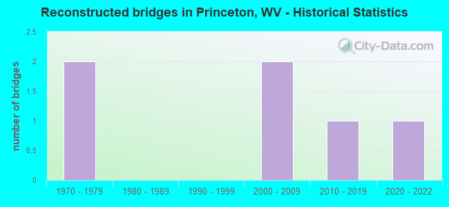
- Reconstructed bridges - Historical Statistics
- 21970-1979
- 01980-1989
- 01990-1999
- 22000-2009
- 12010-2019
- 12020-2022
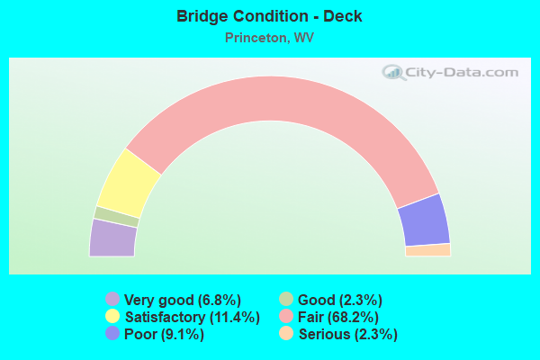
- Bridge Condition - Deck
- 6.8%Very good
- 2.3%Good
- 11.4%Satisfactory
- 68.2%Fair
- 9.1%Poor
- 2.3%Serious
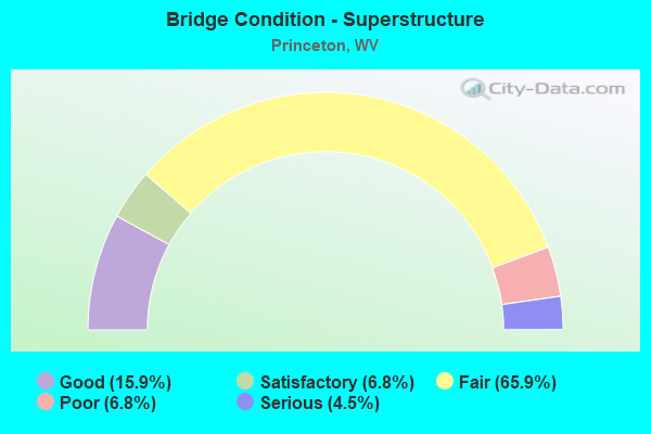
- Bridge Condition - Superstructure
- 15.9%Good
- 6.8%Satisfactory
- 65.9%Fair
- 6.8%Poor
- 4.5%Serious
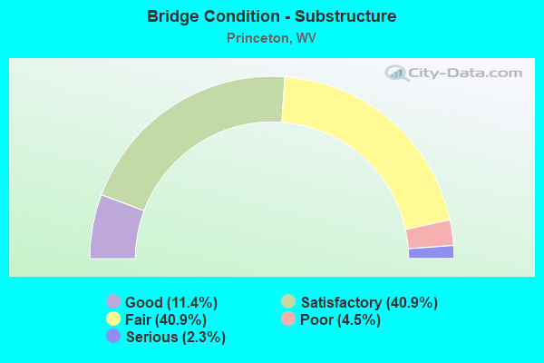
- Bridge Condition - Substructure
- 11.4%Good
- 40.9%Satisfactory
- 40.9%Fair
- 4.5%Poor
- 2.3%Serious
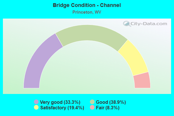
- Bridge Condition - Channel
- 33.3%Very good
- 38.9%Good
- 19.4%Satisfactory
- 8.3%Fair
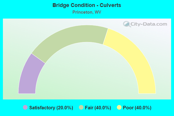
- Bridge Condition - Culverts
- 20.0%Satisfactory
- 40.0%Fair
- 40.0%Poor
Find on map >> Show street view
Structure Number: 28A201, Location: 1.96 MI N OF I 460 (Lat: 37.386589, Lng: -81.054611), Route carried "on" structure: Interstate 7700, Year Built: 1979, Year Reconstructed: 2020, Status: Open, Structure Length: 5.19m (17.03ft), Average Daily Traffic: 17,653 (year 2013), Truck Traffic: 23%, Average Future Daily Traffic: 21,537 (year 2033), Design Load: HS 20+Mod, Features Intersected: WV Rt 20, Facility Carried by Structure: I-77 SB
Minimum Vertical Clearance: 30+ m (98+ ft), Kilometerpoint: 17.526, Lanes on structure: 2, Lanes under structure: 2, Base Highway Network: Yes, Toll: On Interstate toll segment, Owner: State Toll Authority, Approaching Roadway Width: 11.3m (37.1ft), Skew: 11 degrees, Material/Design: Steel continuous, Design/Construction: Stringer/Multi-beam, Number Of Spans In Main Unit: 1, Number Of Approach Spans: 2, Length of Maximum Span: 21.4m (70.2ft), Curb-To-Curb Width: 12.3m (40.4ft), Out-to-Out Width: 13.6m (44.6ft)
Condition: Deck: Very good, Superstructure: Satisfactory, Substructure: Satisfactory, Operating Rating: 61.7 metric tons, Method Used To Determine Operating Rating: Load Factor (LF), Inventory Rating: 37.2 metric tons, Method Used To Determine Inventory Rating: Load Factor (LF), Structural Evaluation: Equal to present minimum criteria, Deck Geometry: Better than present minimum criteria, Underclear: Equal to present minimum criteria, Approach Roadway Alignment: Equal to present desirable criteria, Designated Inspection Frequency: Every 24 months, Inspection Date: September 2020, Deck Structure Type: Concrete Cast-file-Place, Wearing Surface/Protective System: Wearing Surface: Epoxy Overlay, Membrane: Epoxy, Deck Protection: Epoxy Coated Reinforcing
Find on map >> Show street view
Structure Number: 28A219, Location: 0.04 MI W OF CR 7/1 (Lat: 37.403969, Lng: -81.115789), Route carried "on" structure: County highway 1914, Year Built: 1995, Status: Open, Structure Length: 1.02m (3.35ft), Average Daily Traffic: 250 (year 2019), Truck Traffic: 6%, Average Future Daily Traffic: 300 (year 2039), Design Load: HS 25 or greater, Features Intersected: BLACKLICK CREEK, Facility Carried by Structure: CR 19/14
Minimum Vertical Clearance: 30+ m (98+ ft), Kilometerpoint: 1.931, Lanes on structure: 2, Owner: State Highway Agency, Approaching Roadway Width: 5.5m (18.0ft), Material/Design: Prestressed concrete, Design/Construction: Box Beam or Girders - Multiple, Number Of Spans In Main Unit: 1, Length of Maximum Span: 9.1m (29.9ft), Curb-To-Curb Width: 6.5m (21.3ft), Out-to-Out Width: 6.6m (21.7ft)
Condition: Deck: Fair, Superstructure: Fair, Substructure: Fair, Channel: Good, Operating Rating: 88.9 metric tons, Method Used To Determine Operating Rating: Load Factor (LF), Inventory Rating: 53.5 metric tons, Method Used To Determine Inventory Rating: Load Factor (LF), Structural Evaluation: Somewhat better than minimum adequacy, Deck Geometry: Meets minimum limits, Waterway Adequacy: Better than present minimum criteria, Approach Roadway Alignment: Meets minimum limits, Length Of Structure Improvement: 1.04m (3.41ft), Designated Inspection Frequency: Every 24 months, Inspection Date: December 2021, Bridge Improvement Cost: $450,000, Roadway Improvement Cost: $50,000, Total Project Cost: $500,000 ( Estimate for 2022), Deck Structure Type: Other, Wearing Surface/Protective System: Deck Protection: Epoxy Coated Reinforcing
Find on map >> Show street view
Structure Number: 28A303, Location: 0.01 MI EAST OF CO 16 (Lat: 37.402589, Lng: -81.076450), Route carried "on" structure: County highway 1625, Year Built: 1999, Status: Open, Structure Length: 2.00m (6.56ft), Average Daily Traffic: 30 (year 2018), Truck Traffic: 2%, Average Future Daily Traffic: 36 (year 2038), Design Load: HS 25 or greater, Features Intersected: BRUSH CREEK, Facility Carried by Structure: COUNTY ROUTE 16/25
Minimum Vertical Clearance: 30+ m (98+ ft), Kilometerpoint: 0.016, Lanes on structure: 2, Owner: State Highway Agency, Approaching Roadway Width: 9.1m (29.9ft), Material/Design: Prestressed concrete, Design/Construction: Box Beam or Girders - Multiple, Number Of Spans In Main Unit: 1, Length of Maximum Span: 18.9m (62.0ft), Curb-To-Curb Width: 7.3m (24.0ft), Out-to-Out Width: 7.4m (24.3ft)
Condition: Deck: Fair, Superstructure: Fair, Substructure: Satisfactory, Channel: Very good, Operating Rating: 88.9 metric tons, Method Used To Determine Operating Rating: Load Factor (LF), Inventory Rating: 56.2 metric tons, Method Used To Determine Inventory Rating: Load Factor (LF), Structural Evaluation: Somewhat better than minimum adequacy, Deck Geometry: Equal to present minimum criteria, Waterway Adequacy: Equal to present desirable criteria, Approach Roadway Alignment: Equal to present minimum criteria, Designated Inspection Frequency: Every 24 months, Inspection Date: August 2020, Deck Structure Type: Other, Wearing Surface/Protective System: Deck Protection: Epoxy Coated Reinforcing
Find on map >> Show street view
Structure Number: 28A306, Location: 0.48 MI NORTH OF WV 123 (Lat: 37.322431, Lng: -81.137361), Route carried "on" structure: County highway 1933, Year Built: 2002, Status: Open, Structure Length: 1.03m (3.38ft), Average Daily Traffic: 6,200 (year 2019), Truck Traffic: 6%, Average Future Daily Traffic: 7,440 (year 2039), Design Load: HS 25 or greater, Features Intersected: SOUTH FORK, Facility Carried by Structure: COUNTY ROUTE 19/33
Minimum Vertical Clearance: 30+ m (98+ ft), Kilometerpoint: 5.005, Lanes on structure: 2, Owner: State Highway Agency, Approaching Roadway Width: 9.1m (29.9ft), Material/Design: Prestressed concrete, Design/Construction: Box Beam or Girders - Multiple, Number Of Spans In Main Unit: 1, Length of Maximum Span: 9.1m (29.9ft), Curb-To-Curb Width: 8.4m (27.6ft), Out-to-Out Width: 8.4m (27.6ft)
Condition: Deck: Fair, Superstructure: Fair, Substructure: Fair, Channel: Satisfactory, Operating Rating: 57.1 metric tons, Method Used To Determine Operating Rating: Load Factor (LF), Inventory Rating: 34.5 metric tons, Method Used To Determine Inventory Rating: Load Factor (LF), Structural Evaluation: Somewhat better than minimum adequacy, Deck Geometry: High priority of replacement, Waterway Adequacy: Superior to present desirable criteria, Approach Roadway Alignment: Equal to present desirable criteria, Length Of Structure Improvement: 1.03m (3.38ft), Designated Inspection Frequency: Every 24 months, Inspection Date: November 2021, Bridge Improvement Cost: $850,000, Roadway Improvement Cost: $100,000, Total Project Cost: $950,000 ( Estimate for 2022), Deck Structure Type: Other, Wearing Surface/Protective System: Wearing Surface: Bituminous, Deck Protection: Epoxy Coated Reinforcing
Find on map >> Show street view
Structure Number: 28A314, Location: 0.17 MILE E OF CO 460/7 (Lat: 37.362900, Lng: -81.048769), Route carried "on" structure: US 46000, Year Built: 2007, Status: Open, Structure Length: 7.64m (25.07ft), Average Daily Traffic: 12,900 (year 2019), Truck Traffic: 9%, Average Future Daily Traffic: 13,545 (year 2039), Design Load: HL 93, Features Intersected: I-77, Facility Carried by Structure: US 460
Minimum Vertical Clearance: 30+ m (98+ ft), Kilometerpoint: 25.057, Lanes on structure: 4, Lanes under structure: 4, Base Highway Network: Yes, Owner: State Highway Agency, Approaching Roadway Width: 12.2m (40.0ft), Skew: 24 degrees, Material/Design: Steel continuous, Design/Construction: Stringer/Multi-beam, Number Of Spans In Main Unit: 2, Length of Maximum Span: 37.3m (122.4ft), Curb-To-Curb Width: 32.9m (107.9ft), Out-to-Out Width: 34.9m (114.5ft)
Condition: Deck: Fair, Superstructure: Fair, Substructure: Fair, Operating Rating: 43.5 metric tons, Method Used To Determine Operating Rating: Load and Resistance Factor (LRFR), Inventory Rating: 33.6 metric tons, Method Used To Determine Inventory Rating: Load and Resistance Factor (LRFR), Structural Evaluation: Somewhat better than minimum adequacy, Deck Geometry: Superior to present desirable criteria, Underclear: Equal to present desirable criteria, Approach Roadway Alignment: Equal to present desirable criteria, Designated Inspection Frequency: Every 24 months, Inspection Date: December 2021, Deck Structure Type: Concrete Cast-file-Place, Wearing Surface/Protective System: Wearing Surface: Bituminous, Deck Protection: Epoxy Coated Reinforcing
Find on map >> Show street view
Structure Number: 28A319, Location: 0.03 MI SOUTH OF CO 19/29 (Lat: 37.342761, Lng: -81.126969), Route carried "on" structure: County highway 1949, Year Built: 1936, Status: Posted for load, Structure Length: 0.98m (3.22ft), Average Daily Traffic: 350 (year 2018), Truck Traffic: 2%, Average Future Daily Traffic: 424 (year 2038), Features Intersected: BRUSH CREEK, Facility Carried by Structure: COUNTY ROUTE 19/49
Minimum Vertical Clearance: 30+ m (98+ ft), Kilometerpoint: 0.048, Lanes on structure: 2, Owner: State Highway Agency, Approaching Roadway Width: 7.3m (24.0ft), Material/Design: Concrete, Design/Construction: Slab, Number Of Spans In Main Unit: 1, Length of Maximum Span: 9.4m (30.8ft), Curb or Sidewalk Widths: Left: 0.2m (0.7ft), Right: 0.2m (0.7ft), Curb-To-Curb Width: 12.3m (40.4ft), Out-to-Out Width: 13.2m (43.3ft)
Condition: Deck: Fair, Superstructure: Fair, Substructure: Fair, Channel: Very good, Operating Rating: 47.2 metric tons, Method Used To Determine Operating Rating: Field evaluation and documented engineering judgment, Inventory Rating: 21.8 metric tons, Method Used To Determine Inventory Rating: Field evaluation and documented engineering judgment, Structural Evaluation: Somewhat better than minimum adequacy, Deck Geometry: Superior to present desirable criteria, Waterway Adequacy: Superior to present desirable criteria, Approach Roadway Alignment: Equal to present minimum criteria, Length Of Structure Improvement: 0.98m (3.22ft), Designated Inspection Frequency: Every 24 months, Inspection Date: January 2020, Bridge Improvement Cost: $400,000, Roadway Improvement Cost: $75,000, Total Project Cost: $475,000 ( Estimate for 2020), Deck Structure Type: Concrete Cast-file-Place, Wearing Surface/Protective System: Wearing Surface: Bituminous
Find on map >> Show street view
Structure Number: 28A329, Location: 0.08 MI. N. OF CR 27 (Lat: 37.358289, Lng: -81.101219), Route carried "on" structure: County highway 1966, Year Built: 2002, Status: Open, Structure Length: 1.36m (4.46ft), Average Daily Traffic: 2,600 (year 2019), Truck Traffic: 6%, Average Future Daily Traffic: 3,120 (year 2039), Design Load: HS 25 or greater, Features Intersected: Glady Fork, Facility Carried by Structure: County Route 19/66
Minimum Vertical Clearance: 30+ m (98+ ft), Kilometerpoint: 0.129, Lanes on structure: 2, Owner: State Highway Agency, Approaching Roadway Width: 92.4m (303.1ft), Skew: 6 degrees, Material/Design: Concrete, Design/Construction: Culvert, Number Of Spans In Main Unit: 1, Length of Maximum Span: 13.6m (44.6ft), Curb-To-Curb Width: 7.4m (24.3ft), Out-to-Out Width: 10.5m (34.4ft)
Condition: Channel: Very good, Culverts: Fair, Operating Rating: 88.9 metric tons, Method Used To Determine Operating Rating: Field evaluation and documented engineering judgment, Inventory Rating: 40.8 metric tons, Method Used To Determine Inventory Rating: Field evaluation and documented engineering judgment, Structural Evaluation: Somewhat better than minimum adequacy, Deck Geometry: High priority of replacement, Waterway Adequacy: Superior to present desirable criteria, Approach Roadway Alignment: Equal to present desirable criteria, Designated Inspection Frequency: Every 24 months, Inspection Date: December 2021, Deck Structure Type: Other, Wearing Surface/Protective System: Wearing Surface: Bituminous
Find on map >> Show street view
Structure Number: 28A33, Location: 0.06 Mi. S. Of Co. 19/55 (Lat: 37.323661, Lng: -81.139411), Route carried "on" structure: County highway 1955, Year Built: 1992, Status: Open, Structure Length: 1.57m (5.15ft), Average Daily Traffic: 20 (year 2018), Truck Traffic: 2%, Average Future Daily Traffic: 24 (year 2038), Design Load: HS 25 or greater, Features Intersected: Brush Creek, Facility Carried by Structure: Co. 19/55
Minimum Vertical Clearance: 30+ m (98+ ft), Kilometerpoint: 0.097, Lanes on structure: 2, Owner: State Highway Agency, Approaching Roadway Width: 5.5m (18.0ft), Skew: 1 degrees, Material/Design: Prestressed concrete, Design/Construction: Box Beam or Girders - Multiple, Number Of Spans In Main Unit: 1, Length of Maximum Span: 15.2m (49.9ft), Curb-To-Curb Width: 6.3m (20.7ft), Out-to-Out Width: 6.5m (21.3ft)
Condition: Deck: Fair, Superstructure: Fair, Substructure: Good, Channel: Good, Operating Rating: 88.9 metric tons, Method Used To Determine Operating Rating: Load Factor (LF), Inventory Rating: 67.1 metric tons, Method Used To Determine Inventory Rating: Load Factor (LF), Structural Evaluation: Somewhat better than minimum adequacy, Deck Geometry: Somewhat better than minimum adequacy, Waterway Adequacy: Equal to present minimum criteria, Approach Roadway Alignment: Equal to present minimum criteria, Designated Inspection Frequency: Every 24 months, Inspection Date: September 2020, Deck Structure Type: Other, Wearing Surface/Protective System: Deck Protection: Epoxy Coated Reinforcing
Find on map >> Show street view
Structure Number: 28A34, Location: 0.23 MI E OF CR 219/21 (Lat: 37.364119, Lng: -81.086850), Route carried "on" structure: State highway 104, Year Built: 2020, Status: Open, Structure Length: 2.88m (9.45ft), Average Daily Traffic: 20,300 (year 2019), Truck Traffic: 5%, Average Future Daily Traffic: 21,315 (year 2039), Design Load: HL 93, Features Intersected: Brush Creek
Minimum Vertical Clearance: 30+ m (98+ ft), Kilometerpoint: 3.106, Lanes on structure: 2, Owner: State Highway Agency, Approaching Roadway Width: 12.8m (42.0ft), Material/Design: Prestressed concrete, Design/Construction: Stringer/Multi-beam, Number Of Spans In Main Unit: 1, Length of Maximum Span: 28.0m (91.9ft), Curb or Sidewalk Widths: Left: 0.4m (1.3ft), Right: 1.5m (4.9ft), Curb-To-Curb Width: 11.3m (37.1ft), Out-to-Out Width: 13.5m (44.3ft)
Condition: Deck: Good, Superstructure: Good, Substructure: Good, Channel: Good, Operating Rating: 57.1 metric tons, Method Used To Determine Operating Rating: Load and Resistance Factor (LRFR), Inventory Rating: 37.2 metric tons, Method Used To Determine Inventory Rating: Load and Resistance Factor (LRFR), Structural Evaluation: Better than present minimum criteria, Deck Geometry: Meets minimum limits, Waterway Adequacy: Equal to present minimum criteria, Approach Roadway Alignment: Equal to present minimum criteria, Designated Inspection Frequency: Every 24 months, Inspection Date: July 2021, Deck Structure Type: Concrete Cast-file-Place, Wearing Surface/Protective System: Wearing Surface: Monolithic Concrete, Membrane: Built-up, Deck Protection: Epoxy Coated Reinforcing
Find on map >> Show street view
Structure Number: 28A907, Location: 0.18 MI N OF WV 104 (Lat: 37.366469, Lng: -81.082931), Route carried "on" structure: City street N1300, Year Built: 1993, Status: Open, Structure Length: 1.34m (4.40ft), Average Daily Traffic: 1,200 (year 2018), Truck Traffic: 5%, Average Future Daily Traffic: 1,452 (year 2038), Design Load: HS 25 or greater, Features Intersected: DAVES FORK, Facility Carried by Structure: WICKHAM AVENUE
Minimum Vertical Clearance: 30+ m (98+ ft), Kilometerpoint: 0.016, Lanes on structure: 2, Owner: City or Municipal Highway Agency, Approaching Roadway Width: 9.8m (32.2ft), Material/Design: Prestressed concrete, Design/Construction: Box Beam or Girders - Multiple, Number Of Spans In Main Unit: 1, Length of Maximum Span: 12.2m (40.0ft), Curb-To-Curb Width: 9.3m (30.5ft), Out-to-Out Width: 9.3m (30.5ft)
Condition: Deck: Fair, Superstructure: Fair, Substructure: Satisfactory, Channel: Very good, Operating Rating: 88.9 metric tons, Method Used To Determine Operating Rating: Load Factor (LF), Inventory Rating: 63.5 metric tons, Method Used To Determine Inventory Rating: Load Factor (LF), Structural Evaluation: Somewhat better than minimum adequacy, Deck Geometry: Somewhat better than minimum adequacy, Waterway Adequacy: Equal to present minimum criteria, Approach Roadway Alignment: Superior to present desirable criteria, Designated Inspection Frequency: Every 24 months, Inspection Date: December 2020, Deck Structure Type: Other, Wearing Surface/Protective System: Deck Protection: Epoxy Coated Reinforcing
Find on map >> Show street view
Structure Number: 28A058, Location: 0.19 MI N OF CR 19/36 (Lat: 37.398439, Lng: -81.134619), Route carried "under" structure: US 1900, Year Built: 1925, Structure Length: 0. m, Average Daily Traffic: 4,700 (year 2019), Truck Traffic: 9%, Features Intersected: NS RAILROAD, Facility Carried by Structure: NS RAILWAY
Minimum Vertical Clearance: 4.39m (14.40ft), Kilometerpoint: 27.182, Lanes under structure: 2, Length of Maximum Span: 13.7m (44.9ft)
Find on map >> Show street view
Structure Number: 28A076, Location: 0.28 MI. S. OF CR. 44/10 (Lat: 37.371089, Lng: -81.085389), Route carried "under" structure: County highway 10405, Year Built: 1947, Structure Length: 0. m, Average Daily Traffic: 100 (year 0009), Features Intersected: C104/5 & NSRR & BRUSH CR, Facility Carried by Structure: WV. RTE. 20
Minimum Vertical Clearance: 7.62m (25.00ft), Kilometerpoint: 1.207, Lanes on structure: 2, Lanes under structure: 2, Length of Maximum Span: 32.3m (106.0ft)
Find on map >> Show street view
Structure Number: 28A085, Location: 0.32 MI W OF CR 24 (Lat: 37.378961, Lng: -81.044189), Route carried "under" structure: Interstate 7700, Year Built: 1950, Structure Length: 0. m, Average Daily Traffic: 13,000 (year 0009), Truck Traffic: 23%, Features Intersected: I 77 South Bound, Facility Carried by Structure: CR 24/1
Minimum Vertical Clearance: 7.98m (26.18ft), Kilometerpoint: 16.254, Lanes on structure: 2, Lanes under structure: 2, Length of Maximum Span: 15.6m (51.2ft)
Find on map >> Show street view
Structure Number: 28A1, Location: 0.11 MI S OF CR 14 (Lat: 37.394089, Lng: -81.060489), Route carried "under" structure: Interstate 7700, Year Built: 1950, Structure Length: 0. m, Average Daily Traffic: 26,000 (year 0010), Truck Traffic: 28%, Features Intersected: I 77, Facility Carried by Structure: CR 44/10
Minimum Vertical Clearance: 9.14m (29.99ft), Kilometerpoint: 18.701, Lanes on structure: 2, Lanes under structure: 5, Toll: On toll road, Length of Maximum Span: 31.4m (103.0ft)
Find on map >> Show street view
Structure Number: 28A115, Location: 1.85 MI. N. OF WV 112 (Lat: 37.338989, Lng: -81.060619), Route carried "under" structure: Ramp Interstate 7700, Year Built: 1969, Structure Length: 0. m, Average Daily Traffic: 200 (year 0010), Truck Traffic: 6%, Features Intersected: I-77 NB, Facility Carried by Structure: INTERSTATE 77 NB
Minimum Vertical Clearance: 4.32m (14.17ft), Kilometerpoint: 0.048, Lanes on structure: 2, Lanes under structure: 1, Length of Maximum Span: 25.6m (84.0ft)
Find on map >> Show street view
Structure Number: 28A157, Location: 0.28 MI WEST OF CO 24 (Lat: 37.379231, Lng: -81.043869), Route carried "under" structure: Interstate 7700, Year Built: 1977, Structure Length: 0. m, Average Daily Traffic: 14,000 (year 0010), Truck Traffic: 23%, Features Intersected: I 77 North, Facility Carried by Structure: COUNTY ROUTE 24/1
Minimum Vertical Clearance: 7.39m (24.25ft), Kilometerpoint: 16.254, Lanes on structure: 2, Lanes under structure: 2, Length of Maximum Span: 63.4m (208.0ft)
Find on map >> Show street view
Structure Number: 28A163, Location: 1.81 MI N OF WV 112 (Lat: 37.339089, Lng: -81.060911), Route carried "under" structure: Ramp Interstate 7700, Year Built: 1967, Structure Length: 0. m, Average Daily Traffic: 200 (year 0010), Truck Traffic: 6%, Features Intersected: I-77 Ramp H, Facility Carried by Structure: I-77 SOUTHBOUND
Minimum Vertical Clearance: 6.45m (21.16ft), Kilometerpoint: 0.000, Lanes on structure: 2, Lanes under structure: 1, Length of Maximum Span: 25.6m (84.0ft)
Find on map >> Show street view
Structure Number: 28A164, Location: 0.08 MI. N. OF CR.219/6 (Lat: 37.363961, Lng: -81.085531), Route carried "under" structure: State highway 10400, Year Built: 1924, Structure Length: 0. m, Average Daily Traffic: 20,300 (year 2019), Truck Traffic: 5%, Features Intersected: NORTHFORK SOUTHERN RR, Facility Carried by Structure: NS RAILWAY
Minimum Vertical Clearance: 4.27m (14.01ft), Kilometerpoint: 3.251, Lanes under structure: 2, Material/Design: Steel, Design/Construction: Stringer/Multi-beam, Length of Maximum Span: 7.3m (24.0ft)
Find on map >> Show street view
Structure Number: 28A314, Location: 0.17 MILE E OF CO 460/7 (Lat: 37.363161, Lng: -81.048139), Route carried "under" structure: Interstate 7700, Year Built: 2007, Structure Length: 0. m, Average Daily Traffic: 22,600 (year 0012), Truck Traffic: 23%, Features Intersected: I-77, Facility Carried by Structure: US 460
Minimum Vertical Clearance: 5.28m (17.32ft), Kilometerpoint: 14.420, Lanes on structure: 4, Lanes under structure: 4, Length of Maximum Span: 37.3m (122.4ft)