Bridge Statistics for Pontoon Beach, Illinois (IL)
Condition, Traffic, Stress, Structural Evaluation, Project Costs
- National Bridge Inventory (NBI) Statistics
- 58Number of bridges
- 669ft / 204mTotal length
- $6,978,000Total costs
- 919,770Total average daily traffic
- 137,428Total average daily truck traffic
- National Bridge Inventory (NBI) Registered Bridges for Pontoon Beach
- No street view available for this location
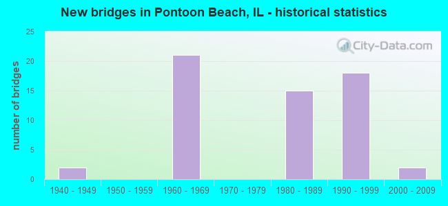
- New bridges - historical statistics
- 21940-1949
- 211960-1969
- 151980-1989
- 181990-1999
- 22000-2009

- Reconstructed bridges - Historical Statistics
- 11970-1979
- 11980-1989
- 51990-1999


- Bridge Condition - Deck
- 11.5%Very good
- 46.2%Good
- 34.6%Satisfactory
- 7.7%Fair

- Bridge Condition - Superstructure
- 19.2%Very good
- 50.0%Good
- 15.4%Satisfactory
- 11.5%Fair
- 3.8%Poor

- Bridge Condition - Substructure
- 23.1%Very good
- 50.0%Good
- 19.2%Satisfactory
- 7.7%Fair

- Bridge Condition - Channel
- 9.1%Excellent
- 63.6%Very good
- 27.3%Good

- Bridge Condition - Culverts
- 66.7%Very good
- 33.3%Good
Find on map >> Show street view
Structure Number: 600042, Location: 1.5 MI W OF IL 111 (Lat: 38.759811, Lng: -90.095339), Route carried "on" structure: Interstate 270, Year Built: 1961, Year Reconstructed: 1997, Status: Open, Structure Length: 18.07m (59.28ft), Average Daily Traffic: 26,775 (year 2021), Truck Traffic: 18%, Average Future Daily Traffic: 91,743 (year 2032), Design Load: HS 20+Mod, Features Intersected: IL203,OldAltonRd &RR
Minimum Vertical Clearance: 30+ m (98+ ft), Kilometerpoint: 6.759, Lanes on structure: 3, Lanes under structure: 4, Base Highway Network: Yes, Owner: State Highway Agency, Approaching Roadway Width: 21.6m (70.9ft), Skew: 31 degrees, Material/Design: Steel continuous, Design/Construction: Stringer/Multi-beam, Number Of Spans In Main Unit: 10, Length of Maximum Span: 22.9m (75.1ft), Curb-To-Curb Width: 22.6m (74.1ft), Out-to-Out Width: 24.3m (79.7ft)
Condition: Deck: Good, Superstructure: Good, Substructure: Good, Operating Rating: 70.0 metric tons, Method Used To Determine Operating Rating: Load Factor (LF) rating reported by rating factor (RF) method using MS18 loading, Inventory Rating: 37.6 metric tons, Method Used To Determine Inventory Rating: Load Factor (LF) rating reported by rating factor (RF) method using MS18 loading, Structural Evaluation: Better than present minimum criteria, Deck Geometry: Superior to present desirable criteria, Underclear: High priority of corrective action, Approach Roadway Alignment: Equal to present desirable criteria, Designated Inspection Frequency: Every 24 months, Inspection Date: January 2022, Deck Structure Type: Concrete Cast-file-Place, Wearing Surface/Protective System: Deck Protection: Epoxy Coated Reinforcing
Find on map >> Show street view
Structure Number: 600043, Location: 1.5 MI W OF IL 111 (Lat: 38.759417, Lng: -90.094256), Route carried "on" structure: Interstate 270, Year Built: 1961, Year Reconstructed: 1998, Status: Open, Structure Length: 18.04m (59.19ft), Average Daily Traffic: 28,100 (year 2021), Truck Traffic: 18%, Average Future Daily Traffic: 30,591 (year 2032), Design Load: HS 20+Mod, Features Intersected: IL203,OldAltonRd &RR
Minimum Vertical Clearance: 30+ m (98+ ft), Kilometerpoint: 6.775, Lanes on structure: 4, Lanes under structure: 4, Base Highway Network: Yes, Owner: State Highway Agency, Approaching Roadway Width: 22.6m (74.1ft), Skew: 31 degrees, Material/Design: Steel continuous, Design/Construction: Stringer/Multi-beam, Number Of Spans In Main Unit: 10, Length of Maximum Span: 22.9m (75.1ft), Curb-To-Curb Width: 22.6m (74.1ft), Out-to-Out Width: 24.3m (79.7ft)
Condition: Deck: Good, Superstructure: Good, Substructure: Good, Operating Rating: 70.0 metric tons, Method Used To Determine Operating Rating: Load Factor (LF) rating reported by rating factor (RF) method using MS18 loading, Inventory Rating: 37.6 metric tons, Method Used To Determine Inventory Rating: Load Factor (LF) rating reported by rating factor (RF) method using MS18 loading, Structural Evaluation: Better than present minimum criteria, Deck Geometry: Superior to present desirable criteria, Underclear: High priority of replacement, Approach Roadway Alignment: Equal to present desirable criteria, Length Of Structure Improvement: 18.04m (59.19ft), Designated Inspection Frequency: Every 24 months, Inspection Date: January 2022, Bridge Improvement Cost: $4,120,000, Roadway Improvement Cost: $41,000, Total Project Cost: $4,161,000, Deck Structure Type: Concrete Cast-file-Place, Wearing Surface/Protective System: Deck Protection: Epoxy Coated Reinforcing
Find on map >> Show street view
Structure Number: 600044, Location: 1.25 MI W OF IL 111 (Lat: 38.758022, Lng: -90.089692), Route carried "on" structure: Interstate 270, Year Built: 1962, Status: Open, Structure Length: 8.51m (27.92ft), Average Daily Traffic: 29,650 (year 2021), Truck Traffic: 18%, Average Future Daily Traffic: 91,743 (year 2032), Design Load: HS 20+Mod, Features Intersected: ENGINEER RD & RR
Minimum Vertical Clearance: 30+ m (98+ ft), Kilometerpoint: 7.242, Lanes on structure: 3, Lanes under structure: 2, Base Highway Network: Yes, Owner: State Highway Agency, Approaching Roadway Width: 21.6m (70.9ft), Skew: 30 degrees, Material/Design: Steel continuous, Design/Construction: Stringer/Multi-beam, Number Of Spans In Main Unit: 3, Length of Maximum Span: 40.2m (131.9ft), Curb-To-Curb Width: 19.1m (62.7ft), Out-to-Out Width: 20.8m (68.2ft)
Condition: Deck: Good, Superstructure: Very good, Substructure: Good, Operating Rating: 89.4 metric tons, Method Used To Determine Operating Rating: Load Factor (LF) rating reported by rating factor (RF) method using MS18 loading, Inventory Rating: 50.5 metric tons, Method Used To Determine Inventory Rating: Load Factor (LF) rating reported by rating factor (RF) method using MS18 loading, Structural Evaluation: Better than present minimum criteria, Deck Geometry: Superior to present desirable criteria, Underclear: Superior to present desirable criteria, Approach Roadway Alignment: Equal to present desirable criteria, Designated Inspection Frequency: Every 24 months, Inspection Date: January 2022, Deck Structure Type: Concrete Cast-file-Place, Wearing Surface/Protective System: Deck Protection: Epoxy Coated Reinforcing
Find on map >> Show street view
Structure Number: 600045, Location: 1.25 MI W OF IL 111 (Lat: 38.757961, Lng: -90.089411), Route carried "on" structure: Interstate 270, Year Built: 1962, Year Reconstructed: 1998, Status: Open, Structure Length: 8.51m (27.92ft), Average Daily Traffic: 27,350 (year 2021), Truck Traffic: 19%, Average Future Daily Traffic: 31,969 (year 2032), Design Load: HS 20+Mod, Features Intersected: ENGINEER RD & RR
Minimum Vertical Clearance: 30+ m (98+ ft), Kilometerpoint: 7.258, Lanes on structure: 3, Lanes under structure: 2, Base Highway Network: Yes, Owner: State Highway Agency, Approaching Roadway Width: 18.3m (60.0ft), Skew: 30 degrees, Material/Design: Steel continuous, Design/Construction: Stringer/Multi-beam, Number Of Spans In Main Unit: 3, Length of Maximum Span: 40.1m (131.6ft), Curb-To-Curb Width: 19.2m (63.0ft), Out-to-Out Width: 20.3m (66.6ft)
Condition: Deck: Good, Superstructure: Very good, Substructure: Good, Operating Rating: 97.2 metric tons, Method Used To Determine Operating Rating: Load Factor (LF) rating reported by rating factor (RF) method using MS18 loading, Inventory Rating: 58.6 metric tons, Method Used To Determine Inventory Rating: Load Factor (LF) rating reported by rating factor (RF) method using MS18 loading, Structural Evaluation: Better than present minimum criteria, Deck Geometry: Superior to present desirable criteria, Underclear: Superior to present desirable criteria, Approach Roadway Alignment: Equal to present desirable criteria, Length Of Structure Improvement: 8.47m (27.79ft), Designated Inspection Frequency: Every 24 months, Inspection Date: January 2022, Bridge Improvement Cost: $1,168,000, Roadway Improvement Cost: $117,000, Total Project Cost: $1,285,000, Deck Structure Type: Concrete Cast-file-Place, Wearing Surface/Protective System: Deck Protection: Epoxy Coated Reinforcing
Find on map >> Show street view
Structure Number: 600046, Location: AT PONTOON BEACH (Lat: 38.757408, Lng: -90.067083), Route carried "on" structure: Interstate 270, Year Built: 1961, Year Reconstructed: 1997, Status: Open, Structure Length: 6.84m (22.44ft), Average Daily Traffic: 26,750 (year 2021), Truck Traffic: 18%, Average Future Daily Traffic: 29,256 (year 2032), Design Load: HS 20+Mod, Features Intersected: ILL 111
Minimum Vertical Clearance: 30+ m (98+ ft), Kilometerpoint: 9.253, Lanes on structure: 3, Lanes under structure: 4, Base Highway Network: Yes, Owner: State Highway Agency, Approaching Roadway Width: 11.6m (38.1ft), Skew: 1 degrees, Material/Design: Steel continuous, Design/Construction: Stringer/Multi-beam, Number Of Spans In Main Unit: 4, Length of Maximum Span: 20.9m (68.6ft), Curb-To-Curb Width: 17.2m (56.4ft), Out-to-Out Width: 19.1m (62.7ft)
Condition: Deck: Satisfactory, Superstructure: Satisfactory, Substructure: Fair, Operating Rating: 73.5 metric tons, Method Used To Determine Operating Rating: Load Factor (LF) rating reported by rating factor (RF) method using MS18 loading, Inventory Rating: 39.5 metric tons, Method Used To Determine Inventory Rating: Load Factor (LF) rating reported by rating factor (RF) method using MS18 loading, Structural Evaluation: Somewhat better than minimum adequacy, Deck Geometry: Better than present minimum criteria, Underclear: Meets minimum limits, Approach Roadway Alignment: Equal to present desirable criteria, Designated Inspection Frequency: Every 24 months, Inspection Date: January 2022, Deck Structure Type: Concrete Cast-file-Place, Wearing Surface/Protective System: Deck Protection: Epoxy Coated Reinforcing
Find on map >> Show street view
Structure Number: 600047, Location: AT PONTOON BEACH (Lat: 38.757400, Lng: -90.066831), Route carried "on" structure: Interstate 270, Year Built: 1961, Year Reconstructed: 1998, Status: Open, Structure Length: 6.84m (22.44ft), Average Daily Traffic: 26,750 (year 2021), Truck Traffic: 18%, Average Future Daily Traffic: 29,256 (year 2032), Design Load: HS 20+Mod, Features Intersected: ILL 111
Minimum Vertical Clearance: 30+ m (98+ ft), Kilometerpoint: 9.270, Lanes on structure: 3, Lanes under structure: 4, Base Highway Network: Yes, Owner: State Highway Agency, Approaching Roadway Width: 18.9m (62.0ft), Skew: 1 degrees, Material/Design: Steel continuous, Design/Construction: Stringer/Multi-beam, Number Of Spans In Main Unit: 4, Length of Maximum Span: 21.0m (68.9ft), Curb-To-Curb Width: 17.1m (56.1ft), Out-to-Out Width: 18.2m (59.7ft)
Condition: Deck: Satisfactory, Superstructure: Satisfactory, Substructure: Fair, Operating Rating: 73.5 metric tons, Method Used To Determine Operating Rating: Load Factor (LF) rating reported by rating factor (RF) method using MS18 loading, Inventory Rating: 39.5 metric tons, Method Used To Determine Inventory Rating: Load Factor (LF) rating reported by rating factor (RF) method using MS18 loading, Structural Evaluation: Somewhat better than minimum adequacy, Deck Geometry: Equal to present minimum criteria, Underclear: Meets minimum limits, Approach Roadway Alignment: Equal to present desirable criteria, Length Of Structure Improvement: 6.80m (22.31ft), Designated Inspection Frequency: Every 24 months, Inspection Date: January 2022, Bridge Improvement Cost: $840,000, Roadway Improvement Cost: $84,000, Total Project Cost: $924,000, Deck Structure Type: Concrete Cast-file-Place, Wearing Surface/Protective System: Deck Protection: Epoxy Coated Reinforcing
Find on map >> Show street view
Structure Number: 600048, Location: 1.03mi W. of IL 157 (Lat: 38.756717, Lng: -90.025158), Route carried "on" structure: Interstate 270, Year Built: 1963, Status: Open, Structure Length: 1.13m (3.71ft), Average Daily Traffic: 25,200 (year 2021), Truck Traffic: 17%, Average Future Daily Traffic: 27,719 (year 2032), Design Load: HS 20+Mod, Features Intersected: COUNTY DITCH
Minimum Vertical Clearance: 30+ m (98+ ft), Kilometerpoint: 12.778, Lanes on structure: 3, Base Highway Network: Yes, Owner: State Highway Agency, Approaching Roadway Width: 17.4m (57.1ft), Material/Design: Steel, Design/Construction: Stringer/Multi-beam, Number Of Spans In Main Unit: 1, Length of Maximum Span: 11.0m (36.1ft), Curb-To-Curb Width: 20.0m (65.6ft), Out-to-Out Width: 21.0m (68.9ft)
Condition: Deck: Satisfactory, Superstructure: Poor, Substructure: Satisfactory, Channel: Good, Operating Rating: 61.6 metric tons, Method Used To Determine Operating Rating: Load Factor (LF) rating reported by rating factor (RF) method using MS18 loading, Inventory Rating: 36.9 metric tons, Method Used To Determine Inventory Rating: Load Factor (LF) rating reported by rating factor (RF) method using MS18 loading, Structural Evaluation: Meets minimum limits, Deck Geometry: Superior to present desirable criteria, Waterway Adequacy: Equal to present desirable criteria, Approach Roadway Alignment: Equal to present desirable criteria, Designated Inspection Frequency: Every 12 months, Inspection Date: January 2022, Deck Structure Type: Concrete Cast-file-Place, Wearing Surface/Protective System: Wearing Surface: Other, Deck Protection: Other
Find on map >> Show street view
Structure Number: 600049, Location: 1.03mi W. of IL 157 (Lat: 38.756714, Lng: -90.024811), Route carried "on" structure: Interstate 270, Year Built: 1963, Status: Open, Structure Length: 1.13m (3.71ft), Average Daily Traffic: 25,200 (year 2021), Truck Traffic: 17%, Average Future Daily Traffic: 27,719 (year 2032), Design Load: HS 20+Mod, Features Intersected: COUNTY DITCH
Minimum Vertical Clearance: 30+ m (98+ ft), Kilometerpoint: 12.794, Lanes on structure: 3, Base Highway Network: Yes, Owner: State Highway Agency, Approaching Roadway Width: 17.4m (57.1ft), Material/Design: Steel, Design/Construction: Stringer/Multi-beam, Number Of Spans In Main Unit: 1, Length of Maximum Span: 11.3m (37.1ft), Curb-To-Curb Width: 20.0m (65.6ft), Out-to-Out Width: 21.0m (68.9ft)
Condition: Deck: Satisfactory, Superstructure: Fair, Substructure: Good, Channel: Good, Operating Rating: 55.1 metric tons, Method Used To Determine Operating Rating: Load Factor (LF) rating reported by rating factor (RF) method using MS18 loading, Inventory Rating: 33.0 metric tons, Method Used To Determine Inventory Rating: Load Factor (LF) rating reported by rating factor (RF) method using MS18 loading, Structural Evaluation: Somewhat better than minimum adequacy, Deck Geometry: Superior to present desirable criteria, Waterway Adequacy: Equal to present desirable criteria, Approach Roadway Alignment: Equal to present desirable criteria, Designated Inspection Frequency: Every 24 months, Inspection Date: January 2022, Deck Structure Type: Concrete Cast-file-Place, Wearing Surface/Protective System: Wearing Surface: Other, Deck Protection: Other
Find on map >> Show street view
Structure Number: 60006, Location: 1 mi W IL 157 on FR (Lat: 38.756447, Lng: -90.037883), Route carried "on" structure: Other road , Year Built: 1964, Status: Open, Structure Length: 1.13m (3.71ft), Average Daily Traffic: 25 (year 2021), Average Future Daily Traffic: 11 (year 2032), Design Load: HS 15, Features Intersected: COUNTY DITCH, Facility Carried by Structure: FAI 270 FR RD 610
Minimum Vertical Clearance: 30+ m (98+ ft), Kilometerpoint: 0.097, Lanes on structure: 2, Owner: State Highway Agency, Approaching Roadway Width: 8.5m (27.9ft), Material/Design: Concrete, Design/Construction: Channel Beam, Number Of Spans In Main Unit: 1, Length of Maximum Span: 10.7m (35.1ft), Curb-To-Curb Width: 7.3m (24.0ft), Out-to-Out Width: 8.0m (26.2ft)
Condition: Deck: Good, Superstructure: Satisfactory, Substructure: Good, Channel: Good, Operating Rating: 51.5 metric tons, Method Used To Determine Operating Rating: Allowable Stress (AS) rating reported by rating factor (RF) method using MS18 loading, Inventory Rating: 35.3 metric tons, Method Used To Determine Inventory Rating: Allowable Stress (AS) rating reported by rating factor (RF) method using MS18 loading, Structural Evaluation: Equal to present minimum criteria, Deck Geometry: Equal to present minimum criteria, Waterway Adequacy: Equal to present desirable criteria, Approach Roadway Alignment: Equal to present minimum criteria, Designated Inspection Frequency: Every 24 months, Inspection Date: January 2022, Deck Structure Type: Concrete Precast Panels, Wearing Surface/Protective System: Wearing Surface: Gravel
Find on map >> Show street view
Structure Number: 600124, Location: .25 M N IL 162 (Lat: 38.723961, Lng: -90.070828), Route carried "on" structure: State highway 111, Year Built: 1940, Year Reconstructed: 1986, Status: Open, Structure Length: 11.58m (37.99ft), Average Daily Traffic: 10,000 (year 2021), Truck Traffic: 7%, Average Future Daily Traffic: 12,720 (year 2032), Design Load: HS 20, Features Intersected: NWRR/CNWRR/BikeTrail
Minimum Vertical Clearance: 30+ m (98+ ft), Kilometerpoint: 15.095, Lanes on structure: 2, Base Highway Network: Yes, Owner: State Highway Agency, Approaching Roadway Width: 10.4m (34.1ft), Skew: 2 degrees, Material/Design: Steel continuous, Design/Construction: Stringer/Multi-beam, Number Of Spans In Main Unit: 6, Length of Maximum Span: 24.1m (79.1ft), Curb or Sidewalk Widths: Left: 1.5m (4.9ft), Right: 0.0m, Curb-To-Curb Width: 12.9m (42.3ft), Out-to-Out Width: 15.2m (49.9ft)
Condition: Deck: Satisfactory, Superstructure: Fair, Substructure: Satisfactory, Operating Rating: 68.4 metric tons, Method Used To Determine Operating Rating: Load Factor (LF) rating reported by rating factor (RF) method using MS18 loading, Inventory Rating: 39.5 metric tons, Method Used To Determine Inventory Rating: Load Factor (LF) rating reported by rating factor (RF) method using MS18 loading, Structural Evaluation: Somewhat better than minimum adequacy, Deck Geometry: Somewhat better than minimum adequacy, Underclear: Somewhat better than minimum adequacy, Approach Roadway Alignment: Equal to present minimum criteria, Designated Inspection Frequency: Every 24 months, Inspection Date: April 2021, Deck Structure Type: Concrete Cast-file-Place, Wearing Surface/Protective System: Deck Protection: Epoxy Coated Reinforcing
Find on map >> Show street view
Structure Number: 60017, Location: 1.86 MI W OF IL 157 (Lat: 38.669528, Lng: -90.042022), Route carried "on" structure: County highway , Year Built: 1960, Year Reconstructed: 1984, Status: Open, Structure Length: 8.11m (26.61ft), Average Daily Traffic: 1,050 (year 2021), Truck Traffic: 15%, Average Future Daily Traffic: 1,060 (year 2032), Design Load: HS 15, Features Intersected: FAI 55/70/US 40, Facility Carried by Structure: FAIRMONT LANE
Minimum Vertical Clearance: 30+ m (98+ ft), Kilometerpoint: 1.255, Lanes on structure: 2, Lanes under structure: 4, Owner: State Highway Agency, Approaching Roadway Width: 8.5m (27.9ft), Skew: 3 degrees, Material/Design: Concrete continuous, Design/Construction: Stayed Girder, Number Of Spans In Main Unit: 2, Length of Maximum Span: 23.8m (78.1ft), Curb-To-Curb Width: 7.3m (24.0ft), Out-to-Out Width: 9.1m (29.9ft)
Condition: Deck: Fair, Superstructure: Fair, Substructure: Satisfactory, Operating Rating: 44.1 metric tons, Method Used To Determine Operating Rating: Load Factor (LF) rating reported by rating factor (RF) method using MS18 loading, Inventory Rating: 32.4 metric tons, Method Used To Determine Inventory Rating: Load Factor (LF) rating reported by rating factor (RF) method using MS18 loading, Structural Evaluation: Somewhat better than minimum adequacy, Deck Geometry: Meets minimum limits, Underclear: High priority of corrective action, Approach Roadway Alignment: Equal to present desirable criteria, Length Of Structure Improvement: 8.11m (26.61ft), Designated Inspection Frequency: Every 12 months, Other Special Inspection Frequency: Every 3 months, Inspection Date: December 2021, Other Special Inspection Date: December 2021, Bridge Improvement Cost: $553,000, Roadway Improvement Cost: $55,000, Total Project Cost: $608,000, Deck Structure Type: Concrete Cast-file-Place
Find on map >> Show street view
Structure Number: 600171, Location: 0.4 mi W of IL 157 (Lat: 38.756725, Lng: -90.025853), Route carried "on" structure: City street , Year Built: 1963, Status: Open, Structure Length: 6.77m (22.21ft), Average Daily Traffic: 20 (year 2021), Truck Traffic: 25%, Average Future Daily Traffic: 186 (year 2032), Design Load: HS 15, Features Intersected: I-270, Facility Carried by Structure: SAND ROAD/ CITY ST
Minimum Vertical Clearance: 30+ m (98+ ft), Kilometerpoint: 0.370, Lanes on structure: 2, Lanes under structure: 4, Owner: State Highway Agency, Approaching Roadway Width: 8.5m (27.9ft), Material/Design: Steel continuous, Design/Construction: Stringer/Multi-beam, Number Of Spans In Main Unit: 4, Length of Maximum Span: 20.4m (66.9ft), Curb-To-Curb Width: 6.1m (20.0ft), Out-to-Out Width: 7.2m (23.6ft)
Condition: Deck: Good, Superstructure: Good, Substructure: Good, Operating Rating: 49.6 metric tons, Method Used To Determine Operating Rating: Load Factor (LF) rating reported by rating factor (RF) method using MS18 loading, Inventory Rating: 29.8 metric tons, Method Used To Determine Inventory Rating: Load Factor (LF) rating reported by rating factor (RF) method using MS18 loading, Structural Evaluation: Better than present minimum criteria, Deck Geometry: Somewhat better than minimum adequacy, Underclear: Meets minimum limits, Approach Roadway Alignment: Equal to present minimum criteria, Designated Inspection Frequency: Every 24 months, Inspection Date: January 2022, Deck Structure Type: Concrete Cast-file-Place
Find on map >> Show street view
Structure Number: 600218, Location: .9MI SO ILL 162 (Lat: 38.722931, Lng: -90.030331), Route carried "on" structure: Interstate 255, Year Built: 1985, Status: Open, Structure Length: 12.32m (40.42ft), Average Daily Traffic: 20,850 (year 2021), Truck Traffic: 11%, Average Future Daily Traffic: 22,843 (year 2032), Design Load: HS 20, Features Intersected: CAHOKIA CANAL
Minimum Vertical Clearance: 30+ m (98+ ft), Kilometerpoint: 39.251, Lanes on structure: 3, Base Highway Network: Yes, Owner: State Highway Agency, Approaching Roadway Width: 17.1m (56.1ft), Skew: 13 degrees, Material/Design: Steel continuous, Design/Construction: Stringer/Multi-beam, Number Of Spans In Main Unit: 3, Length of Maximum Span: 46.7m (153.2ft), Curb-To-Curb Width: 17.1m (56.1ft), Out-to-Out Width: 18.0m (59.1ft)
Condition: Deck: Good, Superstructure: Good, Substructure: Satisfactory, Channel: Very good, Operating Rating: 69.7 metric tons, Method Used To Determine Operating Rating: Load Factor (LF) rating reported by rating factor (RF) method using MS18 loading, Inventory Rating: 41.8 metric tons, Method Used To Determine Inventory Rating: Load Factor (LF) rating reported by rating factor (RF) method using MS18 loading, Structural Evaluation: Equal to present minimum criteria, Deck Geometry: Equal to present minimum criteria, Waterway Adequacy: Equal to present desirable criteria, Approach Roadway Alignment: Equal to present desirable criteria, Designated Inspection Frequency: Every 24 months, Inspection Date: January 2021, Deck Structure Type: Concrete Cast-file-Place, Wearing Surface/Protective System: Wearing Surface: Bituminous, Membrane: Built-up, Deck Protection: Epoxy Coated Reinforcing
Find on map >> Show street view
Structure Number: 600219, Location: .9MI SO ILL 162 (Lat: 38.723044, Lng: -90.030481), Route carried "on" structure: Interstate 255, Year Built: 1985, Status: Open, Structure Length: 12.32m (40.42ft), Average Daily Traffic: 20,850 (year 2021), Truck Traffic: 11%, Average Future Daily Traffic: 22,843 (year 2032), Design Load: HS 20, Features Intersected: CAHOKIA CANAL
Minimum Vertical Clearance: 30+ m (98+ ft), Kilometerpoint: 39.267, Lanes on structure: 3, Base Highway Network: Yes, Owner: State Highway Agency, Approaching Roadway Width: 17.1m (56.1ft), Skew: 13 degrees, Material/Design: Steel continuous, Design/Construction: Stringer/Multi-beam, Number Of Spans In Main Unit: 3, Length of Maximum Span: 46.7m (153.2ft), Curb-To-Curb Width: 17.1m (56.1ft), Out-to-Out Width: 18.0m (59.1ft)
Condition: Deck: Good, Superstructure: Good, Substructure: Satisfactory, Channel: Very good, Operating Rating: 69.7 metric tons, Method Used To Determine Operating Rating: Load Factor (LF) rating reported by rating factor (RF) method using MS18 loading, Inventory Rating: 41.8 metric tons, Method Used To Determine Inventory Rating: Load Factor (LF) rating reported by rating factor (RF) method using MS18 loading, Structural Evaluation: Equal to present minimum criteria, Deck Geometry: Equal to present minimum criteria, Waterway Adequacy: Superior to present desirable criteria, Approach Roadway Alignment: Equal to present desirable criteria, Designated Inspection Frequency: Every 24 months, Inspection Date: January 2021, Deck Structure Type: Concrete Cast-file-Place, Wearing Surface/Protective System: Wearing Surface: Bituminous, Membrane: Built-up, Deck Protection: Epoxy Coated Reinforcing
Find on map >> Show street view
Structure Number: 60022, Location: 2 MI W ILL 157 (Lat: 38.732803, Lng: -90.038378), Route carried "on" structure: Interstate 255, Year Built: 1987, Status: Open, Structure Length: 10.90m (35.76ft), Average Daily Traffic: 20,500 (year 2021), Truck Traffic: 11%, Average Future Daily Traffic: 21,571 (year 2032), Design Load: HS 20, Features Intersected: IL 162/BIKE TRAIL/RR
Minimum Vertical Clearance: 30+ m (98+ ft), Kilometerpoint: 40.747, Lanes on structure: 3, Lanes under structure: 2, Base Highway Network: Yes, Owner: State Highway Agency, Approaching Roadway Width: 16.9m (55.4ft), Material/Design: Steel continuous, Design/Construction: Stringer/Multi-beam, Number Of Spans In Main Unit: 2, Length of Maximum Span: 53.9m (176.8ft), Curb-To-Curb Width: 17.9m (58.7ft), Out-to-Out Width: 18.7m (61.4ft)
Condition: Deck: Satisfactory, Superstructure: Good, Substructure: Good, Operating Rating: 61.2 metric tons, Method Used To Determine Operating Rating: Load Factor (LF) rating reported by rating factor (RF) method using MS18 loading, Inventory Rating: 36.9 metric tons, Method Used To Determine Inventory Rating: Load Factor (LF) rating reported by rating factor (RF) method using MS18 loading, Structural Evaluation: Better than present minimum criteria, Deck Geometry: Better than present minimum criteria, Underclear: Equal to present minimum criteria, Approach Roadway Alignment: Equal to present desirable criteria, Designated Inspection Frequency: Every 24 months, Inspection Date: January 2021, Deck Structure Type: Concrete Cast-file-Place, Wearing Surface/Protective System: Deck Protection: Epoxy Coated Reinforcing
Find on map >> Show street view
Structure Number: 600221, Location: 2 MI W ILL 157 (Lat: 38.732689, Lng: -90.038331), Route carried "on" structure: Interstate 255, Year Built: 1987, Status: Open, Structure Length: 10.88m (35.70ft), Average Daily Traffic: 20,850 (year 2021), Truck Traffic: 11%, Average Future Daily Traffic: 22,843 (year 2032), Design Load: HS 20, Features Intersected: IL 162/BIKE TRAIL/RR
Minimum Vertical Clearance: 30+ m (98+ ft), Kilometerpoint: 40.731, Lanes on structure: 3, Lanes under structure: 2, Base Highway Network: Yes, Owner: State Highway Agency, Approaching Roadway Width: 17.0m (55.8ft), Material/Design: Steel continuous, Design/Construction: Stringer/Multi-beam, Number Of Spans In Main Unit: 2, Length of Maximum Span: 53.9m (176.8ft), Curb-To-Curb Width: 21.2m (69.6ft), Out-to-Out Width: 22.2m (72.8ft)
Condition: Deck: Good, Superstructure: Good, Substructure: Good, Operating Rating: 60.3 metric tons, Method Used To Determine Operating Rating: Load Factor (LF) rating reported by rating factor (RF) method using MS18 loading, Inventory Rating: 36.0 metric tons, Method Used To Determine Inventory Rating: Load Factor (LF) rating reported by rating factor (RF) method using MS18 loading, Structural Evaluation: Better than present minimum criteria, Deck Geometry: Superior to present desirable criteria, Underclear: Equal to present minimum criteria, Approach Roadway Alignment: Equal to present desirable criteria, Designated Inspection Frequency: Every 24 months, Inspection Date: January 2021, Deck Structure Type: Concrete Cast-file-Place, Wearing Surface/Protective System: Deck Protection: Epoxy Coated Reinforcing
Find on map >> Show street view
Structure Number: 600222, Location: 1.9MI W ILL 157 (Lat: 38.756239, Lng: -90.043539), Route carried "on" structure: Interstate 255, Year Built: 1987, Status: Open, Structure Length: 8.46m (27.76ft), Average Daily Traffic: 20,500 (year 2021), Truck Traffic: 11%, Average Future Daily Traffic: 21,571 (year 2032), Design Load: HS 20, Features Intersected: I-270
Minimum Vertical Clearance: 30+ m (98+ ft), Kilometerpoint: 43.467, Lanes on structure: 3, Lanes under structure: 9, Base Highway Network: Yes, Owner: State Highway Agency, Approaching Roadway Width: 17.1m (56.1ft), Material/Design: Steel continuous, Design/Construction: Stringer/Multi-beam, Number Of Spans In Main Unit: 3, Number Of Approach Spans: 2, Length of Maximum Span: 32.9m (107.9ft), Curb-To-Curb Width: 17.1m (56.1ft), Out-to-Out Width: 18.0m (59.1ft)
Condition: Deck: Good, Superstructure: Good, Substructure: Good, Operating Rating: 58.6 metric tons, Method Used To Determine Operating Rating: Load Factor (LF) rating reported by rating factor (RF) method using MS18 loading, Inventory Rating: 35.3 metric tons, Method Used To Determine Inventory Rating: Load Factor (LF) rating reported by rating factor (RF) method using MS18 loading, Structural Evaluation: Better than present minimum criteria, Deck Geometry: Equal to present minimum criteria, Underclear: High priority of corrective action, Approach Roadway Alignment: Equal to present desirable criteria, Designated Inspection Frequency: Every 24 months, Inspection Date: November 2020, Deck Structure Type: Concrete Cast-file-Place, Wearing Surface/Protective System: Wearing Surface: Bituminous, Membrane: Built-up, Deck Protection: Epoxy Coated Reinforcing
Find on map >> Show street view
Structure Number: 600224, Location: 1.8MI W ILL 157 (Lat: 38.756483, Lng: -90.040539), Route carried "on" structure: Other road , Year Built: 1987, Status: Open, Structure Length: 10.27m (33.69ft), Average Daily Traffic: 5,300 (year 2016), Truck Traffic: 17%, Average Future Daily Traffic: 5,512 (year 2032), Design Load: HS 20, Features Intersected: I-270, Facility Carried by Structure: Ramp 255NB to 270W
Minimum Vertical Clearance: 30+ m (98+ ft), Kilometerpoint: 1.802, Lanes on structure: 2, Lanes under structure: 12, Base Highway Network: Yes (Inventory Route: 10255040, Subroute: 20), Owner: State Highway Agency, Approaching Roadway Width: 11.5m (37.7ft), Material/Design: Steel continuous, Design/Construction: Stringer/Multi-beam, Number Of Spans In Main Unit: 5, Length of Maximum Span: 26.5m (86.9ft), Curb-To-Curb Width: 12.3m (40.4ft), Out-to-Out Width: 13.1m (43.0ft)
Condition: Deck: Fair, Superstructure: Satisfactory, Substructure: Good, Operating Rating: 85.5 metric tons, Method Used To Determine Operating Rating: Load Factor (LF) rating reported by rating factor (RF) method using MS18 loading, Inventory Rating: 51.5 metric tons, Method Used To Determine Inventory Rating: Load Factor (LF) rating reported by rating factor (RF) method using MS18 loading, Structural Evaluation: Equal to present minimum criteria, Deck Geometry: Better than present minimum criteria, Underclear: Equal to present minimum criteria, Approach Roadway Alignment: Equal to present desirable criteria, Designated Inspection Frequency: Every 24 months, Inspection Date: November 2021, Deck Structure Type: Concrete Cast-file-Place, Wearing Surface/Protective System: Deck Protection: Epoxy Coated Reinforcing
Find on map >> Show street view
Structure Number: 600231, Location: .20 MI N OF FAI 270 (Lat: 38.760228, Lng: -90.043572), Route carried "on" structure: State highway 255, Year Built: 1994, Status: Open, Structure Length: 4.63m (15.19ft), Average Daily Traffic: 36,800 (year 2021), Truck Traffic: 14%, Average Future Daily Traffic: 16,483 (year 2032), Design Load: HS 20+Mod, Features Intersected: Ramp 255NB to 270WB
Minimum Vertical Clearance: 30+ m (98+ ft), Kilometerpoint: 0.306, Lanes on structure: 2, Lanes under structure: 2, Base Highway Network: Yes, Owner: State Highway Agency, Approaching Roadway Width: 17.1m (56.1ft), Skew: 1 degrees, Material/Design: Steel continuous, Design/Construction: Stringer/Multi-beam, Number Of Spans In Main Unit: 1, Number Of Approach Spans: 2, Length of Maximum Span: 29.1m (95.5ft), Curb-To-Curb Width: 17.1m (56.1ft), Out-to-Out Width: 18.0m (59.1ft)
Condition: Deck: Satisfactory, Superstructure: Good, Substructure: Very good, Operating Rating: 69.3 metric tons, Method Used To Determine Operating Rating: Load Factor (LF) rating reported by rating factor (RF) method using MS18 loading, Inventory Rating: 41.5 metric tons, Method Used To Determine Inventory Rating: Load Factor (LF) rating reported by rating factor (RF) method using MS18 loading, Structural Evaluation: Better than present minimum criteria, Deck Geometry: Superior to present desirable criteria, Underclear: Equal to present minimum criteria, Approach Roadway Alignment: Equal to present desirable criteria, Designated Inspection Frequency: Every 24 months, Inspection Date: November 2020, Deck Structure Type: Concrete Cast-file-Place, Wearing Surface/Protective System: Deck Protection: Epoxy Coated Reinforcing
Find on map >> Show street view
Structure Number: 600232, Location: .20 MI N OF FAI 270 (Lat: 38.760397, Lng: -90.043575), Route carried "on" structure: State highway 255, Year Built: 1994, Status: Open, Structure Length: 4.63m (15.19ft), Average Daily Traffic: 36,800 (year 2021), Truck Traffic: 14%, Average Future Daily Traffic: 16,483 (year 2032), Design Load: HS 20+Mod, Features Intersected: Ramp 255NB to 270WB
Minimum Vertical Clearance: 30+ m (98+ ft), Kilometerpoint: 0.322, Lanes on structure: 2, Lanes under structure: 2, Base Highway Network: Yes, Owner: State Highway Agency, Approaching Roadway Width: 17.1m (56.1ft), Skew: 1 degrees, Material/Design: Steel continuous, Design/Construction: Stringer/Multi-beam, Number Of Spans In Main Unit: 1, Number Of Approach Spans: 2, Length of Maximum Span: 29.1m (95.5ft), Curb-To-Curb Width: 17.1m (56.1ft), Out-to-Out Width: 18.0m (59.1ft)
Condition: Deck: Satisfactory, Superstructure: Good, Substructure: Good, Operating Rating: 69.3 metric tons, Method Used To Determine Operating Rating: Load Factor (LF) rating reported by rating factor (RF) method using MS18 loading, Inventory Rating: 41.5 metric tons, Method Used To Determine Inventory Rating: Load Factor (LF) rating reported by rating factor (RF) method using MS18 loading, Structural Evaluation: Better than present minimum criteria, Deck Geometry: Superior to present desirable criteria, Underclear: Equal to present minimum criteria, Approach Roadway Alignment: Equal to present desirable criteria, Designated Inspection Frequency: Every 24 months, Inspection Date: November 2020, Deck Structure Type: Concrete Cast-file-Place, Wearing Surface/Protective System: Deck Protection: Epoxy Coated Reinforcing
Find on map >> Show street view
Structure Number: 600233, Location: .20 MI N OF FAI 270 (Lat: 38.760206, Lng: -90.044153), Route carried "on" structure: Other road , Year Built: 1994, Status: Open, Structure Length: 2.99m (9.81ft), Average Daily Traffic: 3,500 (year 2016), Truck Traffic: 15%, Average Future Daily Traffic: 1,494 (year 2032), Design Load: HS 20+Mod, Features Intersected: Ramp 255NB to 270WB, Facility Carried by Structure: IL 255 SB CD
Minimum Vertical Clearance: 30+ m (98+ ft), Kilometerpoint: 0.837, Lanes on structure: 1, Lanes under structure: 2, Base Highway Network: Yes (Inventory Route: 10255070, Subroute: 60), Owner: State Highway Agency, Approaching Roadway Width: 7.9m (25.9ft), Skew: 1 degrees, Material/Design: Steel, Design/Construction: Stringer/Multi-beam, Number Of Spans In Main Unit: 1, Number Of Approach Spans: 2, Length of Maximum Span: 29.1m (95.5ft), Curb-To-Curb Width: 7.9m (25.9ft), Out-to-Out Width: 8.9m (29.2ft)
Condition: Deck: Satisfactory, Superstructure: Good, Substructure: Very good, Operating Rating: 65.8 metric tons, Method Used To Determine Operating Rating: Load Factor (LF) rating reported by rating factor (RF) method using MS18 loading, Inventory Rating: 39.5 metric tons, Method Used To Determine Inventory Rating: Load Factor (LF) rating reported by rating factor (RF) method using MS18 loading, Structural Evaluation: Better than present minimum criteria, Deck Geometry: High priority of corrective action, Underclear: Equal to present minimum criteria, Approach Roadway Alignment: Equal to present desirable criteria, Designated Inspection Frequency: Every 24 months, Inspection Date: November 2020, Deck Structure Type: Concrete Cast-file-Place, Wearing Surface/Protective System: Deck Protection: Epoxy Coated Reinforcing
Find on map >> Show street view
Structure Number: 600236, Location: 2MI EAST IL 111 (Lat: 38.760236, Lng: -90.028219), Route carried "on" structure: Other road , Year Built: 2007, Status: Open, Structure Length: 2.04m (6.69ft), Average Daily Traffic: 2,200 (year 2021), Truck Traffic: 10%, Average Future Daily Traffic: 2,438 (year 2032), Design Load: HS 20, Features Intersected: MADISON CTY DITCH, Facility Carried by Structure: FAU 9079/OLD COR R
Minimum Vertical Clearance: 30+ m (98+ ft), Kilometerpoint: 5.954, Lanes on structure: 2, Base Highway Network: Yes, Owner: State Highway Agency, Approaching Roadway Width: 9.8m (32.2ft), Material/Design: Concrete continuous, Design/Construction: Slab, Number Of Spans In Main Unit: 3, Length of Maximum Span: 7.8m (25.6ft), Curb-To-Curb Width: 13.4m (44.0ft), Out-to-Out Width: 14.4m (47.2ft)
Condition: Deck: Very good, Superstructure: Very good, Substructure: Very good, Channel: Very good, Operating Rating: 67.4 metric tons, Method Used To Determine Operating Rating: Load Factor (LF) rating reported by rating factor (RF) method using MS18 loading, Inventory Rating: 40.5 metric tons, Method Used To Determine Inventory Rating: Load Factor (LF) rating reported by rating factor (RF) method using MS18 loading, Structural Evaluation: Equal to present desirable criteria, Deck Geometry: Better than present minimum criteria, Waterway Adequacy: Equal to present minimum criteria, Approach Roadway Alignment: Equal to present desirable criteria, Designated Inspection Frequency: Every 48 months, Inspection Date: August 2020, Deck Structure Type: Concrete Cast-file-Place, Wearing Surface/Protective System: Deck Protection: Epoxy Coated Reinforcing
Find on map >> Show street view
Structure Number: 600242, Location: 1.9 MI W OF IL 157 (Lat: 38.756122, Lng: -90.043536), Route carried "on" structure: Interstate 255, Year Built: 1994, Status: Open, Structure Length: 10.15m (33.30ft), Average Daily Traffic: 20,500 (year 2021), Truck Traffic: 11%, Average Future Daily Traffic: 21,571 (year 2032), Design Load: HS 20+Mod, Features Intersected: I-270
Minimum Vertical Clearance: 30+ m (98+ ft), Kilometerpoint: 43.451, Lanes on structure: 4, Lanes under structure: 9, Base Highway Network: Yes, Owner: State Highway Agency, Approaching Roadway Width: 19.6m (64.3ft), Material/Design: Steel continuous, Design/Construction: Stringer/Multi-beam, Number Of Spans In Main Unit: 3, Number Of Approach Spans: 2, Length of Maximum Span: 33.1m (108.6ft), Curb-To-Curb Width: 19.6m (64.3ft), Out-to-Out Width: 20.6m (67.6ft)
Condition: Deck: Good, Superstructure: Good, Substructure: Very good, Operating Rating: 61.6 metric tons, Method Used To Determine Operating Rating: Load Factor (LF) rating reported by rating factor (RF) method using MS18 loading, Inventory Rating: 36.9 metric tons, Method Used To Determine Inventory Rating: Load Factor (LF) rating reported by rating factor (RF) method using MS18 loading, Structural Evaluation: Better than present minimum criteria, Deck Geometry: Somewhat better than minimum adequacy, Underclear: High priority of corrective action, Approach Roadway Alignment: Equal to present desirable criteria, Designated Inspection Frequency: Every 24 months, Inspection Date: November 2020, Deck Structure Type: Concrete Cast-file-Place, Wearing Surface/Protective System: Deck Protection: Epoxy Coated Reinforcing
Find on map >> Show street view
Structure Number: 600243, Location: 1.9 M W OF IL 157 (Lat: 38.757261, Lng: -90.044092), Route carried "on" structure: Other road , Year Built: 1994, Status: Open, Structure Length: 10.15m (33.30ft), Average Daily Traffic: 3,500 (year 2016), Truck Traffic: 15%, Average Future Daily Traffic: 5,840 (year 2032), Design Load: HS 20+Mod, Features Intersected: I-270, Facility Carried by Structure: 255 SB COLLECTOR
Minimum Vertical Clearance: 30+ m (98+ ft), Kilometerpoint: 1.143, Lanes on structure: 2, Lanes under structure: 9, Base Highway Network: Yes (Inventory Route: 10255070, Subroute: 60), Owner: State Highway Agency, Approaching Roadway Width: 11.6m (38.1ft), Material/Design: Steel continuous, Design/Construction: Stringer/Multi-beam, Number Of Spans In Main Unit: 3, Number Of Approach Spans: 2, Length of Maximum Span: 33.1m (108.6ft), Curb-To-Curb Width: 11.6m (38.1ft), Out-to-Out Width: 12.5m (41.0ft)
Condition: Deck: Good, Superstructure: Good, Substructure: Very good, Operating Rating: 61.2 metric tons, Method Used To Determine Operating Rating: Load Factor (LF) rating reported by rating factor (RF) method using MS18 loading, Inventory Rating: 36.9 metric tons, Method Used To Determine Inventory Rating: Load Factor (LF) rating reported by rating factor (RF) method using MS18 loading, Structural Evaluation: Better than present minimum criteria, Deck Geometry: Equal to present minimum criteria, Underclear: High priority of corrective action, Approach Roadway Alignment: Equal to present desirable criteria, Designated Inspection Frequency: Every 24 months, Inspection Date: November 2020, Deck Structure Type: Concrete Cast-file-Place, Wearing Surface/Protective System: Deck Protection: Epoxy Coated Reinforcing
Find on map >> Show street view
Structure Number: 600321, Location: 1/2 MI W OF I-255 (Lat: 38.693647, Lng: -90.039828), Route carried "on" structure: Other road , Year Built: 1995, Status: Open, Structure Length: 2.80m (9.19ft), Average Daily Traffic: 9,600 (year 2021), Truck Traffic: 6%, Average Future Daily Traffic: 10,600 (year 2032), Design Load: HS 20+Mod, Features Intersected: CAHOKIA Canal, Facility Carried by Structure: HORSESHOE LAKE RD
Minimum Vertical Clearance: 30+ m (98+ ft), Kilometerpoint: 5.279, Lanes on structure: 2, Base Highway Network: Yes, Owner: State Highway Agency, Approaching Roadway Width: 11.0m (36.1ft), Material/Design: Concrete continuous, Design/Construction: Slab, Number Of Spans In Main Unit: 3, Length of Maximum Span: 11.0m (36.1ft), Curb-To-Curb Width: 12.2m (40.0ft), Out-to-Out Width: 13.1m (43.0ft)
Condition: Deck: Very good, Superstructure: Very good, Substructure: Very good, Channel: Very good, Operating Rating: 60.9 metric tons, Method Used To Determine Operating Rating: Load Factor (LF) rating reported by rating factor (RF) method using MS18 loading, Inventory Rating: 36.6 metric tons, Method Used To Determine Inventory Rating: Load Factor (LF) rating reported by rating factor (RF) method using MS18 loading, Structural Evaluation: Equal to present desirable criteria, Deck Geometry: Somewhat better than minimum adequacy, Waterway Adequacy: Equal to present minimum criteria, Approach Roadway Alignment: Equal to present desirable criteria, Designated Inspection Frequency: Every 48 months, Inspection Date: August 2020, Deck Structure Type: Concrete Cast-file-Place, Wearing Surface/Protective System: Deck Protection: Epoxy Coated Reinforcing
Find on map >> Show street view
Structure Number: 600322, Location: .8MI EAST OF I-255 (Lat: 38.736500, Lng: -90.024469), Route carried "on" structure: State highway 162, Year Built: 1996, Status: Open, Structure Length: 2.38m (7.81ft), Average Daily Traffic: 5,650 (year 2021), Truck Traffic: 6%, Average Future Daily Traffic: 6,572 (year 2032), Design Load: HS 20, Features Intersected: CAHOKIA CANAL
Minimum Vertical Clearance: 30+ m (98+ ft), Kilometerpoint: 9.575, Lanes on structure: 2, Base Highway Network: Yes, Owner: State Highway Agency, Approaching Roadway Width: 10.8m (35.4ft), Skew: 1 degrees, Material/Design: Concrete continuous, Design/Construction: Slab, Number Of Spans In Main Unit: 3, Length of Maximum Span: 8.4m (27.6ft), Curb-To-Curb Width: 12.2m (40.0ft), Out-to-Out Width: 12.8m (42.0ft)
Condition: Deck: Very good, Superstructure: Very good, Substructure: Good, Channel: Very good, Operating Rating: 65.8 metric tons, Method Used To Determine Operating Rating: Load Factor (LF) rating reported by rating factor (RF) method using MS18 loading, Inventory Rating: 39.5 metric tons, Method Used To Determine Inventory Rating: Load Factor (LF) rating reported by rating factor (RF) method using MS18 loading, Structural Evaluation: Better than present minimum criteria, Deck Geometry: Somewhat better than minimum adequacy, Waterway Adequacy: Superior to present desirable criteria, Approach Roadway Alignment: Equal to present desirable criteria, Designated Inspection Frequency: Every 48 months, Inspection Date: August 2020, Deck Structure Type: Concrete Cast-file-Place, Wearing Surface/Protective System: Deck Protection: Epoxy Coated Reinforcing
Find on map >> Show street view
Structure Number: 602009, Location: .75 MI S IL 162 (Lat: 38.710431, Lng: -90.068728), Route carried "on" structure: State highway 111, Year Built: 1940, Status: Open, Structure Length: 0.98m (3.22ft), Average Daily Traffic: 7,500 (year 2021), Truck Traffic: 8%, Average Future Daily Traffic: 8,374 (year 2032), Features Intersected: DRAIN TO HRSESHOE LK
Minimum Vertical Clearance: 30+ m (98+ ft), Kilometerpoint: 13.582, Lanes on structure: 4, Base Highway Network: Yes, Owner: State Highway Agency, Approaching Roadway Width: 8.5m (27.9ft), Material/Design: Concrete continuous, Design/Construction: Culvert, Number Of Spans In Main Unit: 3, Length of Maximum Span: 3.0m (9.8ft)
Condition: Channel: Very good, Culverts: Good, Operating Rating: 64.2 metric tons, Method Used To Determine Operating Rating: Load Factor (LF) rating reported by rating factor (RF) method using MS18 loading, Inventory Rating: 38.6 metric tons, Method Used To Determine Inventory Rating: Load Factor (LF) rating reported by rating factor (RF) method using MS18 loading, Structural Evaluation: Better than present minimum criteria, Waterway Adequacy: Equal to present minimum criteria, Approach Roadway Alignment: Equal to present desirable criteria, Designated Inspection Frequency: Every 24 months, Inspection Date: April 2021
Find on map >> Show street view
Structure Number: 602026, Location: .68MI N BLACK LANE (Lat: 38.701719, Lng: -90.030389), Route carried "on" structure: Interstate 255, Year Built: 1987, Status: Open, Structure Length: 0.68m (2.23ft), Average Daily Traffic: 41,700 (year 2021), Truck Traffic: 11%, Average Future Daily Traffic: 45,686 (year 2032), Design Load: HS 20, Features Intersected: MCDONOUGH LAKE DITCH
Minimum Vertical Clearance: 30+ m (98+ ft), Kilometerpoint: 36.853, Lanes on structure: 6, Base Highway Network: Yes, Owner: State Highway Agency, Approaching Roadway Width: 34.1m (111.9ft), Skew: 30 degrees, Material/Design: Concrete continuous, Design/Construction: Culvert, Number Of Spans In Main Unit: 2, Length of Maximum Span: 3.0m (9.8ft)
Condition: Channel: Very good, Culverts: Very good, Operating Rating: 55.4 metric tons, Method Used To Determine Operating Rating: Load Factor (LF) rating reported by rating factor (RF) method using MS18 loading, Inventory Rating: 34.3 metric tons, Method Used To Determine Inventory Rating: Load Factor (LF) rating reported by rating factor (RF) method using MS18 loading, Structural Evaluation: Equal to present desirable criteria, Waterway Adequacy: Superior to present desirable criteria, Approach Roadway Alignment: Equal to present desirable criteria, Designated Inspection Frequency: Every 24 months, Inspection Date: January 2021
Find on map >> Show street view
Structure Number: 602048, Location: .28MI W OF IL 111 (Lat: 38.708314, Lng: -90.071225), Route carried "on" structure: Other road , Year Built: 2003, Status: Open, Structure Length: 1.08m (3.54ft), Average Daily Traffic: 7,250 (year 2021), Truck Traffic: 7%, Average Future Daily Traffic: 8,374 (year 2032), Design Load: HS 20, Features Intersected: DRAIN TO HRSESHOE LK, Facility Carried by Structure: HORSESHOE LAKE RD
Minimum Vertical Clearance: 30+ m (98+ ft), Kilometerpoint: 1.963, Lanes on structure: 2, Base Highway Network: Yes, Owner: State Highway Agency, Approaching Roadway Width: 13.1m (43.0ft), Material/Design: Concrete, Design/Construction: Culvert, Number Of Spans In Main Unit: 3, Length of Maximum Span: 3.0m (9.8ft), Curb-To-Curb Width: 13.1m (43.0ft), Out-to-Out Width: 13.1m (43.0ft)
Condition: Channel: Excellent, Culverts: Very good, Operating Rating: 44.1 metric tons, Method Used To Determine Operating Rating: Load Factor (LF) rating reported by rating factor (RF) method using MS18 loading, Inventory Rating: 32.4 metric tons, Method Used To Determine Inventory Rating: Load Factor (LF) rating reported by rating factor (RF) method using MS18 loading, Structural Evaluation: Equal to present desirable criteria, Deck Geometry: Somewhat better than minimum adequacy, Waterway Adequacy: Superior to present desirable criteria, Approach Roadway Alignment: Equal to present desirable criteria, Designated Inspection Frequency: Every 48 months, Inspection Date: August 2020
Find on map >> Show street view
Structure Number: 600042, Location: 1.5 MI W OF IL 111 (Lat: 38.759669, Lng: -90.095506), Route carried "under" structure: Other road , Year Built: 1961, Structure Length: 0. m, Average Daily Traffic: 2,700 (year 2021), Truck Traffic: 13%, Features Intersected: IL203,OldAltonRd &RR, Facility Carried by Structure: FAI 270 EB
Minimum Vertical Clearance: 8.99m (29.49ft), Kilometerpoint: 5.021, Lanes on structure: 3, Lanes under structure: 2, Material/Design: Steel continuous, Design/Construction: Stringer/Multi-beam, Length of Maximum Span: 22.9m (75.1ft)
Find on map >> Show street view
Structure Number: 600042, Location: 1.5 MI W OF IL 111 (Lat: 38.759572, Lng: -90.093889), Route carried "under" structure: Other road , Year Built: 1961, Structure Length: 0. m, Average Daily Traffic: 4,600 (year 2021), Truck Traffic: 8%, Features Intersected: IL203,OldAltonRd &RR, Facility Carried by Structure: FAI 270 EB
Minimum Vertical Clearance: 9.45m (31.00ft), Kilometerpoint: 0.032, Lanes on structure: 3, Lanes under structure: 2, Material/Design: Steel continuous, Design/Construction: Stringer/Multi-beam, Length of Maximum Span: 22.9m (75.1ft)
Find on map >> Show street view
Structure Number: 600043, Location: 1.5 MI W OF IL 111 (Lat: 38.759811, Lng: -90.095339), Route carried "under" structure: Other road , Year Built: 1961, Structure Length: 0. m, Average Daily Traffic: 2,700 (year 2021), Truck Traffic: 13%, Features Intersected: IL203,OldAltonRd &RR, Facility Carried by Structure: FAI 270 WB
Minimum Vertical Clearance: 8.99m (29.49ft), Kilometerpoint: 4.989, Lanes on structure: 4, Lanes under structure: 2, Material/Design: Steel continuous, Design/Construction: Stringer/Multi-beam, Length of Maximum Span: 22.9m (75.1ft)
Find on map >> Show street view
Structure Number: 600043, Location: 1.5 MI W OF IL 111 (Lat: 38.759686, Lng: -90.093778), Route carried "under" structure: Other road , Year Built: 1961, Structure Length: 0. m, Average Daily Traffic: 4,600 (year 2021), Truck Traffic: 8%, Features Intersected: IL203,OldAltonRd &RR, Facility Carried by Structure: FAI 270 WB
Minimum Vertical Clearance: 9.45m (31.00ft), Kilometerpoint: 0.048, Lanes on structure: 4, Lanes under structure: 2, Material/Design: Steel continuous, Design/Construction: Stringer/Multi-beam, Length of Maximum Span: 22.9m (75.1ft)
Find on map >> Show street view
Structure Number: 600044, Location: 1.25 MI W OF IL 111 (Lat: 38.758022, Lng: -90.089692), Route carried "under" structure: County highway , Year Built: 1962, Structure Length: 0. m, Average Daily Traffic: 325 (year 2021), Truck Traffic: 15%, Features Intersected: ENGINEER RD & RR, Facility Carried by Structure: FAI 270 EB
Minimum Vertical Clearance: 6.88m (22.57ft), Kilometerpoint: 0.370, Lanes on structure: 3, Lanes under structure: 2, Material/Design: Steel continuous, Design/Construction: Stringer/Multi-beam, Length of Maximum Span: 40.2m (131.9ft)
Find on map >> Show street view
Structure Number: 600045, Location: 1.25 MI W OF IL 111 (Lat: 38.757792, Lng: -90.089694), Route carried "under" structure: City street , Year Built: 1962, Structure Length: 0. m, Average Daily Traffic: 325 (year 2021), Truck Traffic: 15%, Features Intersected: ENGINEER RD & RR, Facility Carried by Structure: FAI 270 WB
Minimum Vertical Clearance: 6.99m (22.93ft), Kilometerpoint: 0.016, Lanes on structure: 3, Lanes under structure: 2, Material/Design: Steel continuous, Design/Construction: Stringer/Multi-beam, Length of Maximum Span: 40.1m (131.6ft)
Find on map >> Show street view
Structure Number: 600046, Location: AT PONTOON BEACH (Lat: 38.757333, Lng: -90.067111), Route carried "under" structure: State highway 111, Year Built: 1961, Structure Length: 0. m, Average Daily Traffic: 12,700 (year 2021), Truck Traffic: 10%, Features Intersected: ILL 111, Facility Carried by Structure: FAI 270 EB
Minimum Vertical Clearance: 4.62m (15.16ft), Kilometerpoint: 18.877, Lanes on structure: 3, Lanes under structure: 4, Material/Design: Steel continuous, Design/Construction: Stringer/Multi-beam, Length of Maximum Span: 20.9m (68.6ft)
Find on map >> Show street view
Structure Number: 600047, Location: AT PONTOON BEACH (Lat: 38.757408, Lng: -90.067083), Route carried "under" structure: State highway 111, Year Built: 1961, Structure Length: 0. m, Average Daily Traffic: 12,700 (year 2021), Truck Traffic: 10%, Features Intersected: ILL 111, Facility Carried by Structure: FAI 270 WB
Minimum Vertical Clearance: 4.67m (15.32ft), Kilometerpoint: 18.909, Lanes on structure: 3, Lanes under structure: 4, Material/Design: Steel continuous, Design/Construction: Stringer/Multi-beam, Length of Maximum Span: 21.0m (68.9ft)
Find on map >> Show street view
Structure Number: 60017, Location: 1.86 MI W OF IL 157 (Lat: 38.669239, Lng: -90.042100), Route carried "under" structure: Interstate 55, Year Built: 1960, Structure Length: 0. m, Average Daily Traffic: 49,700 (year 2021), Truck Traffic: 17%, Features Intersected: FAI 55/70/US 40, Facility Carried by Structure: FAIRMONT LANE
Minimum Vertical Clearance: 4.80m (15.75ft), Kilometerpoint: 14.677, Lanes on structure: 2, Lanes under structure: 4, Material/Design: Concrete continuous, Design/Construction: Stayed Girder, Length of Maximum Span: 23.8m (78.1ft)
Find on map >> Show street view
Structure Number: 600171, Location: 0.4 mi W of IL 157 (Lat: 38.756700, Lng: -90.023422), Route carried "under" structure: Interstate 270, Year Built: 1963, Structure Length: 0. m, Average Daily Traffic: 50,400 (year 2021), Truck Traffic: 17%, Features Intersected: I-270, Facility Carried by Structure: SAND ROAD/ CITY ST
Minimum Vertical Clearance: 4.95m (16.24ft), Kilometerpoint: 12.858, Lanes on structure: 2, Lanes under structure: 4, Material/Design: Steel continuous, Design/Construction: Stringer/Multi-beam, Length of Maximum Span: 20.4m (66.9ft)
Find on map >> Show street view
Structure Number: 60022, Location: 2 MI W ILL 157 (Lat: 38.732711, Lng: -90.038697), Route carried "under" structure: State highway 162, Year Built: 1987, Structure Length: 0. m, Average Daily Traffic: 5,700 (year 2021), Truck Traffic: 7%, Features Intersected: IL 162/BIKE TRAIL/RR, Facility Carried by Structure: FAI 255 SB
Minimum Vertical Clearance: 8.92m (29.27ft), Kilometerpoint: 8.256, Lanes on structure: 3, Lanes under structure: 2, Material/Design: Steel continuous, Design/Construction: Stringer/Multi-beam, Length of Maximum Span: 53.9m (176.8ft)
Find on map >> Show street view
Structure Number: 600221, Location: 2 MI W ILL 157 (Lat: 38.732833, Lng: -90.038258), Route carried "under" structure: State highway 162, Year Built: 1987, Structure Length: 0. m, Average Daily Traffic: 5,650 (year 2021), Truck Traffic: 6%, Features Intersected: IL 162/BIKE TRAIL/RR, Facility Carried by Structure: FAI 255 NB
Minimum Vertical Clearance: 9.04m (29.66ft), Kilometerpoint: 8.288, Lanes on structure: 3, Lanes under structure: 2, Material/Design: Steel continuous, Design/Construction: Stringer/Multi-beam, Length of Maximum Span: 53.9m (176.8ft)
Find on map >> Show street view
Structure Number: 600222, Location: 1.9MI W ILL 157 (Lat: 38.756800, Lng: -90.042483), Route carried "under" structure: Other road , Year Built: 1987, Structure Length: 0. m, Average Daily Traffic: 3,350 (year 2016), Truck Traffic: 19%, Features Intersected: I-270, Facility Carried by Structure: I-255 SB Mainline
Minimum Vertical Clearance: 30+ m (98+ ft), Kilometerpoint: 0.032, Lanes on structure: 3, Lanes under structure: 1, Material/Design: Steel continuous, Design/Construction: Stringer/Multi-beam, Length of Maximum Span: 32.9m (107.9ft)
Find on map >> Show street view
Structure Number: 600222, Location: 1.9MI W ILL 157 (Lat: 38.758461, Lng: -90.044233), Route carried "under" structure: Other road , Year Built: 1987, Structure Length: 0. m, Average Daily Traffic: 4,150 (year 2016), Truck Traffic: 10%, Features Intersected: I-270, Facility Carried by Structure: I-255 SB Mainline
Minimum Vertical Clearance: 30+ m (98+ ft), Kilometerpoint: 0.853, Lanes on structure: 3, Lanes under structure: 1, Material/Design: Steel continuous, Design/Construction: Stringer/Multi-beam, Length of Maximum Span: 32.9m (107.9ft)
Find on map >> Show street view
Structure Number: 600222, Location: 1.9MI W ILL 157 (Lat: 38.757039, Lng: -90.043539), Route carried "under" structure: Interstate 270, Year Built: 1987, Structure Length: 0. m, Average Daily Traffic: 50,400 (year 2021), Truck Traffic: 17%, Features Intersected: I-270, Facility Carried by Structure: I-255 SB Mainline
Minimum Vertical Clearance: 5.46m (17.91ft), Kilometerpoint: 11.297, Lanes on structure: 3, Lanes under structure: 6, Material/Design: Steel continuous, Design/Construction: Stringer/Multi-beam, Length of Maximum Span: 32.9m (107.9ft)
Find on map >> Show street view
Structure Number: 600222, Location: 1.9MI W ILL 157 (Lat: 38.756839, Lng: -90.043539), Route carried "under" structure: Other road , Year Built: 1987, Structure Length: 0. m, Average Daily Traffic: 3,500 (year 2016), Truck Traffic: 15%, Features Intersected: I-270, Facility Carried by Structure: I-255 SB Mainline
Minimum Vertical Clearance: 5.23m (17.16ft), Kilometerpoint: 1.127, Lanes on structure: 3, Lanes under structure: 1, Material/Design: Steel continuous, Design/Construction: Stringer/Multi-beam, Length of Maximum Span: 32.9m (107.9ft)
Find on map >> Show street view
Structure Number: 600224, Location: 1.8MI W ILL 157 (Lat: 38.756775, Lng: -90.039767), Route carried "under" structure: Other road , Year Built: 1987, Structure Length: 0. m, Average Daily Traffic: 3,500 (year 2016), Truck Traffic: 15%, Features Intersected: I-270, Facility Carried by Structure: Ramp 255NB to 270W
Minimum Vertical Clearance: 5.23m (17.16ft), Kilometerpoint: 1.561, Lanes on structure: 2, Lanes under structure: 6, Material/Design: Steel continuous, Design/Construction: Stringer/Multi-beam, Length of Maximum Span: 26.5m (86.9ft)
Find on map >> Show street view
Structure Number: 600224, Location: 1.8MI W ILL 157 (Lat: 38.757028, Lng: -90.042947), Route carried "under" structure: Interstate 270, Year Built: 1987, Structure Length: 0. m, Average Daily Traffic: 50,400 (year 2021), Truck Traffic: 17%, Features Intersected: I-270
Minimum Vertical Clearance: 5.23m (17.16ft), Kilometerpoint: 11.346, Lanes on structure: 2, Lanes under structure: 6, Material/Design: Steel continuous, Design/Construction: Stringer/Multi-beam, Length of Maximum Span: 26.5m (86.9ft)
Find on map >> Show street view
Structure Number: 600231, Location: .20 MI N OF FAI 270 (Lat: 38.759464, Lng: -90.042111), Route carried "under" structure: Other road , Year Built: 1994, Structure Length: 0. m, Average Daily Traffic: 5,300 (year 2016), Truck Traffic: 17%, Features Intersected: Ramp 255NB to 270WB, Facility Carried by Structure: IL 255 NB
Minimum Vertical Clearance: 5.59m (18.34ft), Kilometerpoint: 2.301, Lanes on structure: 2, Lanes under structure: 2, Material/Design: Steel continuous, Design/Construction: Stringer/Multi-beam, Length of Maximum Span: 29.1m (95.5ft)
Find on map >> Show street view
Structure Number: 600232, Location: .20 MI N OF FAI 270 (Lat: 38.759525, Lng: -90.042225), Route carried "under" structure: Other road , Year Built: 1994, Structure Length: 0. m, Average Daily Traffic: 5,300 (year 2016), Truck Traffic: 17%, Features Intersected: Ramp 255NB to 270WB, Facility Carried by Structure: IL 255 SB
Minimum Vertical Clearance: 5.44m (17.85ft), Kilometerpoint: 2.317, Lanes on structure: 2, Lanes under structure: 2, Material/Design: Steel continuous, Design/Construction: Stringer/Multi-beam, Length of Maximum Span: 29.1m (95.5ft)
Find on map >> Show street view
Structure Number: 600233, Location: .20 MI N OF FAI 270 (Lat: 38.759644, Lng: -90.042461), Route carried "under" structure: Other road , Year Built: 1994, Structure Length: 0. m, Average Daily Traffic: 5,300 (year 2016), Truck Traffic: 17%, Features Intersected: Ramp 255NB to 270WB, Facility Carried by Structure: IL 255 SB CD
Minimum Vertical Clearance: 5.59m (18.34ft), Kilometerpoint: 2.350, Lanes on structure: 1, Lanes under structure: 2, Material/Design: Steel, Design/Construction: Stringer/Multi-beam, Length of Maximum Span: 29.1m (95.5ft)
Find on map >> Show street view
Structure Number: 600242, Location: 1.9 MI W OF IL 157 (Lat: 38.756783, Lng: -90.042375), Route carried "under" structure: Other road , Year Built: 1994, Structure Length: 0. m, Average Daily Traffic: 3,350 (year 2016), Truck Traffic: 19%, Features Intersected: I-270, Facility Carried by Structure: I-255 NB Mainline
Minimum Vertical Clearance: 30+ m (98+ ft), Kilometerpoint: 0.048, Lanes on structure: 4, Lanes under structure: 1, Material/Design: Steel continuous, Design/Construction: Stringer/Multi-beam, Length of Maximum Span: 33.1m (108.6ft)
Find on map >> Show street view
Structure Number: 600242, Location: 1.9 MI W OF IL 157 (Lat: 38.756828, Lng: -90.042525), Route carried "under" structure: Other road , Year Built: 1994, Structure Length: 0. m, Average Daily Traffic: 3,500 (year 2016), Truck Traffic: 15%, Features Intersected: I-270, Facility Carried by Structure: I-255 NB Mainline
Minimum Vertical Clearance: 5.21m (17.09ft), Kilometerpoint: 1.304, Lanes on structure: 4, Lanes under structure: 1, Material/Design: Steel continuous, Design/Construction: Stringer/Multi-beam, Length of Maximum Span: 33.1m (108.6ft)
Find on map >> Show street view
Structure Number: 600242, Location: 1.9 MI W OF IL 157 (Lat: 38.758219, Lng: -90.044158), Route carried "under" structure: Other road , Year Built: 1994, Structure Length: 0. m, Average Daily Traffic: 4,150 (year 2016), Truck Traffic: 10%, Features Intersected: I-270, Facility Carried by Structure: I-255 NB Mainline
Minimum Vertical Clearance: 30+ m (98+ ft), Kilometerpoint: 0.885, Lanes on structure: 4, Lanes under structure: 1, Material/Design: Steel continuous, Design/Construction: Stringer/Multi-beam, Length of Maximum Span: 33.1m (108.6ft)