Bridge Statistics for Pismo Beach, California (CA)
Condition, Traffic, Stress, Structural Evaluation, Project Costs
- National Bridge Inventory (NBI) Statistics
- 26Number of bridges
- 262ft / 79.7mTotal length
- 575,100Total average daily traffic
- 52,899Total average daily truck traffic
- National Bridge Inventory (NBI) Registered Bridges for Pismo Beach
- No street view available for this location
- New bridges - historical statistics
- 11940-1949
- 51950-1959
- 161960-1969
- 41990-1999
- Reconstructed bridges - Historical Statistics
- 21970-1979
- 41980-1989
- 21990-1999
- Bridge Condition - Deck
- 80.0%Good
- 20.0%Fair
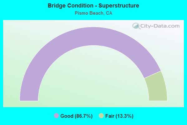
- Bridge Condition - Superstructure
- 86.7%Good
- 13.3%Fair
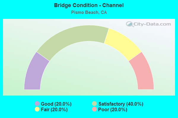
- Bridge Condition - Channel
- 20.0%Good
- 40.0%Satisfactory
- 20.0%Fair
- 20.0%Poor
Find on map >> Show street view
Structure Number: 49 001, Location: 05-SLO-001-15.27-PBCH (Lat: 35.137147, Lng: -120.637986), Route carried "on" structure: State highway 1, Year Built: 1947, Year Reconstructed: 1990, Status: Open, Structure Length: 3.54m (11.61ft), Average Daily Traffic: 9,500 (year 2009), Truck Traffic: 3%, Average Future Daily Traffic: 12,162 (year 2043), Design Load: HS 20, Features Intersected: VILLA CREEK
Minimum Vertical Clearance: 30+ m (98+ ft), Kilometerpoint: 15.270, Lanes on structure: 3, Base Highway Network: Yes (, Subroute: 1), Owner: State Highway Agency, Approaching Roadway Width: 14.0m (45.9ft), Skew: 2 degrees, Material/Design: Concrete continuous, Design/Construction: Slab, Number Of Spans In Main Unit: 5, Length of Maximum Span: 7.6m (24.9ft), Curb-To-Curb Width: 14.0m (45.9ft), Out-to-Out Width: 15.0m (49.2ft)
Condition: Deck: Fair, Superstructure: Fair, Substructure: Good, Channel: Good, Operating Rating: 49.2 metric tons, Method Used To Determine Operating Rating: Load Factor (LF), Inventory Rating: 29.5 metric tons, Method Used To Determine Inventory Rating: Load Factor (LF), Structural Evaluation: Somewhat better than minimum adequacy, Deck Geometry: Somewhat better than minimum adequacy, Waterway Adequacy: Superior to present desirable criteria, Approach Roadway Alignment: Equal to present desirable criteria, Designated Inspection Frequency: Every 24 months, Underwater Inspection Frequency: Every 60 months, Inspection Date: September 2021, Underwater Inspection Date: March 2021, Deck Structure Type: Concrete Cast-file-Place
Find on map >> Show street view
Structure Number: 49 0015K, Location: 05-SLO-101-16.40-PBCH (Lat: 35.139286, Lng: -120.636203), Route carried "on" structure: Ramp US 101, Year Built: 1956, Year Reconstructed: 1978, Status: Open, Structure Length: 4.10m (13.45ft), Average Daily Traffic: 8,400 (year 2011), Truck Traffic: 8%, Average Future Daily Traffic: 9,911 (year 2037), Design Load: HS 20, Features Intersected: PISMO CREEK
Minimum Vertical Clearance: 30+ m (98+ ft), Kilometerpoint: 16.400, Lanes on structure: 1, Base Highway Network: Yes (Inventory Route: 1, Subroute: 1), Owner: State Highway Agency, Approaching Roadway Width: 6.4m (21.0ft), Material/Design: Concrete continuous, Design/Construction: Slab, Number Of Spans In Main Unit: 4, Length of Maximum Span: 10.4m (34.1ft), Curb or Sidewalk Widths: Left: 2.4m (7.9ft), Right: 0.3m (1.0ft), Curb-To-Curb Width: 6.1m (20.0ft), Out-to-Out Width: 10.0m (32.8ft)
Condition: Deck: Good, Superstructure: Good, Substructure: Good, Channel: Poor, Operating Rating: 59.0 metric tons, Method Used To Determine Operating Rating: Load Factor (LF), Inventory Rating: 35.3 metric tons, Method Used To Determine Inventory Rating: Load Factor (LF), Structural Evaluation: Better than present minimum criteria, Deck Geometry: Somewhat better than minimum adequacy, Waterway Adequacy: Equal to present minimum criteria, Approach Roadway Alignment: Equal to present desirable criteria, Designated Inspection Frequency: Every 24 months, Inspection Date: July 2020, Deck Structure Type: Concrete Cast-file-Place, Wearing Surface/Protective System: Wearing Surface: Bituminous
Find on map >> Show street view
Structure Number: 49 0015L, Location: 05-SLO-101-16.40-PBCH (Lat: 35.139436, Lng: -120.635989), Route carried "on" structure: US 101, Year Built: 1960, Year Reconstructed: 1992, Status: Open, Structure Length: 8.05m (26.41ft), Average Daily Traffic: 28,000 (year 2009), Truck Traffic: 9%, Average Future Daily Traffic: 47,251 (year 2037), Design Load: HS 20+Mod, Features Intersected: PISMO CR, N101-PRICE OFF
Minimum Vertical Clearance: 30+ m (98+ ft), Kilometerpoint: 16.400, Lanes on structure: 2, Lanes under structure: 1, Base Highway Network: Yes (Inventory Route: 1, Subroute: 1), Owner: State Highway Agency, Approaching Roadway Width: 11.9m (39.0ft), Skew: 11 degrees, Material/Design: Concrete continuous, Design/Construction: Tee Beam, Number Of Spans In Main Unit: 4, Length of Maximum Span: 27.4m (89.9ft), Curb-To-Curb Width: 11.5m (37.7ft), Out-to-Out Width: 12.9m (42.3ft)
Condition: Deck: Good, Superstructure: Good, Substructure: Good, Channel: Satisfactory, Operating Rating: 41.5 metric tons, Method Used To Determine Operating Rating: Load and Resistance Factor Rating (LRFR) rating reported by rating factor(RF) method using HL-93 loadings, Inventory Rating: 28.5 metric tons, Method Used To Determine Inventory Rating: Load and Resistance Factor Rating (LRFR) rating reported by rating factor(RF) method using HL-93 loadings, Structural Evaluation: Better than present minimum criteria, Deck Geometry: Somewhat better than minimum adequacy, Underclear: Better than present minimum criteria, Waterway Adequacy: Equal to present minimum criteria, Approach Roadway Alignment: Equal to present desirable criteria, Designated Inspection Frequency: Every 24 months, Inspection Date: July 2020, Deck Structure Type: Concrete Cast-file-Place, Wearing Surface/Protective System: Wearing Surface: Bituminous
Find on map >> Show street view
Structure Number: 49 0015R, Location: 05-SLO-101-16.40-PBCH (Lat: 35.139550, Lng: -120.635531), Route carried "on" structure: US 101, Year Built: 1960, Year Reconstructed: 1992, Status: Open, Structure Length: 9.48m (31.10ft), Average Daily Traffic: 28,000 (year 2009), Truck Traffic: 9%, Average Future Daily Traffic: 47,251 (year 2037), Design Load: HS 20+Mod, Features Intersected: PISMO CR, N101-PRICE OFF
Minimum Vertical Clearance: 30+ m (98+ ft), Kilometerpoint: 16.400, Lanes on structure: 2, Lanes under structure: 1, Base Highway Network: Yes (Inventory Route: 1, Subroute: 1), Owner: State Highway Agency, Approaching Roadway Width: 10.4m (34.1ft), Skew: 11 degrees, Material/Design: Concrete continuous, Design/Construction: Tee Beam, Number Of Spans In Main Unit: 4, Length of Maximum Span: 27.4m (89.9ft), Curb-To-Curb Width: 11.5m (37.7ft), Out-to-Out Width: 12.9m (42.3ft)
Condition: Deck: Good, Superstructure: Good, Substructure: Good, Channel: Satisfactory, Operating Rating: 46.7 metric tons, Method Used To Determine Operating Rating: Load and Resistance Factor Rating (LRFR) rating reported by rating factor(RF) method using HL-93 loadings, Inventory Rating: 34.7 metric tons, Method Used To Determine Inventory Rating: Load and Resistance Factor Rating (LRFR) rating reported by rating factor(RF) method using HL-93 loadings, Structural Evaluation: Better than present minimum criteria, Deck Geometry: Somewhat better than minimum adequacy, Underclear: Meets minimum limits, Waterway Adequacy: Better than present minimum criteria, Approach Roadway Alignment: Equal to present desirable criteria, Designated Inspection Frequency: Every 24 months, Inspection Date: July 2020, Deck Structure Type: Concrete Cast-file-Place
Find on map >> Show street view
Structure Number: 49 0015S, Location: 05-SLO-101-16.40-PBCH (Lat: 35.139647, Lng: -120.635939), Route carried "on" structure: Ramp US 101, Year Built: 1960, Status: Open, Structure Length: 4.21m (13.81ft), Average Daily Traffic: 5,900 (year 2014), Truck Traffic: 8%, Average Future Daily Traffic: 6,192 (year 2037), Design Load: HS 20+Mod, Features Intersected: PISMO CREEK
Minimum Vertical Clearance: 4.75m (15.58ft), Kilometerpoint: 16.400, Lanes on structure: 1, Base Highway Network: Yes (Inventory Route: 1, Subroute: 1), Owner: State Highway Agency, Approaching Roadway Width: 6.7m (22.0ft), Skew: 2 degrees, Material/Design: Concrete continuous, Design/Construction: Tee Beam, Number Of Spans In Main Unit: 3, Length of Maximum Span: 17.1m (56.1ft), Curb or Sidewalk Widths: Left: 0.6m (2.0ft), Right: 0.6m (2.0ft), Curb-To-Curb Width: 6.7m (22.0ft), Out-to-Out Width: 8.3m (27.2ft)
Condition: Deck: Fair, Superstructure: Good, Substructure: Good, Channel: Fair, Operating Rating: 43.7 metric tons, Method Used To Determine Operating Rating: Load and Resistance Factor Rating (LRFR) rating reported by rating factor(RF) method using HL-93 loadings, Inventory Rating: 31.4 metric tons, Method Used To Determine Inventory Rating: Load and Resistance Factor Rating (LRFR) rating reported by rating factor(RF) method using HL-93 loadings, Structural Evaluation: Better than present minimum criteria, Deck Geometry: Equal to present minimum criteria, Waterway Adequacy: Equal to present minimum criteria, Approach Roadway Alignment: Somewhat better than minimum adequacy, Designated Inspection Frequency: Every 24 months, Inspection Date: July 2020, Deck Structure Type: Concrete Cast-file-Place
Find on map >> Show street view
Structure Number: 49 0016L, Location: 05-SLO-101-16.17-PBCH (Lat: 35.138394, Lng: -120.631950), Route carried "on" structure: US 101, Year Built: 1956, Year Reconstructed: 1978, Status: Open, Structure Length: 8.62m (28.28ft), Average Daily Traffic: 28,000 (year 2009), Truck Traffic: 9%, Average Future Daily Traffic: 49,176 (year 2044), Design Load: HS 20, Features Intersected: UP RR, AMTRAK, FRADY LN,
Minimum Vertical Clearance: 30+ m (98+ ft), Kilometerpoint: 16.170, Lanes on structure: 3, Lanes under structure: 4, Base Highway Network: Yes (Inventory Route: 1, Subroute: 1), Owner: State Highway Agency, Approaching Roadway Width: 14.0m (45.9ft), Skew: 1 degrees, Material/Design: Concrete continuous, Design/Construction: Slab, Number Of Spans In Main Unit: 7, Length of Maximum Span: 12.2m (40.0ft), Curb or Sidewalk Widths: Left: 2.4m (7.9ft), Right: 0.0m, Curb-To-Curb Width: 14.0m (45.9ft), Out-to-Out Width: 17.8m (58.4ft)
Condition: Deck: Fair, Superstructure: Fair, Substructure: Good, Operating Rating: 73.5 metric tons, Method Used To Determine Operating Rating: Load Factor (LF), Inventory Rating: 44.4 metric tons, Method Used To Determine Inventory Rating: Load Factor (LF), Structural Evaluation: Somewhat better than minimum adequacy, Deck Geometry: Meets minimum limits, Underclear: High priority of corrective action, Approach Roadway Alignment: Equal to present desirable criteria, Designated Inspection Frequency: Every 24 months, Inspection Date: January 2022, Deck Structure Type: Concrete Cast-file-Place
Find on map >> Show street view
Structure Number: 49 0016R, Location: 05-SLO-101-16.17-PBCH (Lat: 35.138694, Lng: -120.631978), Route carried "on" structure: US 101, Year Built: 1956, Year Reconstructed: 1995, Status: Open, Structure Length: 8.62m (28.28ft), Average Daily Traffic: 28,000 (year 2009), Truck Traffic: 9%, Average Future Daily Traffic: 49,176 (year 2044), Design Load: HS 20+Mod, Features Intersected: UP RR, AMTRAK, FRADY LN,
Minimum Vertical Clearance: 30+ m (98+ ft), Kilometerpoint: 16.170, Lanes on structure: 3, Lanes under structure: 4, Base Highway Network: Yes (Inventory Route: 1, Subroute: 1), Owner: State Highway Agency, Approaching Roadway Width: 16.1m (52.8ft), Skew: 12 degrees, Material/Design: Concrete continuous, Design/Construction: Slab, Number Of Spans In Main Unit: 7, Length of Maximum Span: 12.2m (40.0ft), Curb-To-Curb Width: 14.6m (47.9ft), Out-to-Out Width: 16.0m (52.5ft)
Condition: Deck: Good, Superstructure: Good, Substructure: Good, Operating Rating: 54.1 metric tons, Method Used To Determine Operating Rating: Assigned rating based on Load Factor Design (LFD) reported in metric tons, Inventory Rating: 32.4 metric tons, Method Used To Determine Inventory Rating: Assigned rating based on Load Factor Design (LFD) reported in metric tons, Structural Evaluation: Better than present minimum criteria, Deck Geometry: Meets minimum limits, Underclear: High priority of corrective action, Approach Roadway Alignment: Equal to present desirable criteria, Designated Inspection Frequency: Every 24 months, Inspection Date: January 2022, Deck Structure Type: Concrete Cast-file-Place
Find on map >> Show street view
Structure Number: 49 0155, Location: 05-SLO-101-14.61 (Lat: 35.129864, Lng: -120.606589), Route carried "on" structure: County highway Z896, Year Built: 1993, Status: Open, Structure Length: 5.50m (18.04ft), Average Daily Traffic: 3,800 (year 2006), Truck Traffic: 8%, Average Future Daily Traffic: 7,453 (year 2044), Design Load: HS 20+Mod, Features Intersected: US HIGHWAY 101, Facility Carried by Structure: OAK PARK BLVD
Minimum Vertical Clearance: 30+ m (98+ ft), Kilometerpoint: 0.000, Lanes on structure: 6, Lanes under structure: 4, Owner: State Highway Agency, Approaching Roadway Width: 26.8m (87.9ft), Material/Design: Prestressed concrete continuous, Design/Construction: Box Beam or Girders - Multiple, Number Of Spans In Main Unit: 2, Length of Maximum Span: 27.9m (91.5ft), Curb or Sidewalk Widths: Left: 0.0m, Right: 1.5m (4.9ft), Curb-To-Curb Width: 26.8m (87.9ft), Out-to-Out Width: 29.1m (95.5ft)
Condition: Deck: Good, Superstructure: Good, Substructure: Good, Operating Rating: 54.1 metric tons, Method Used To Determine Operating Rating: Assigned rating based on Load Factor Design (LFD) reported in metric tons, Inventory Rating: 32.4 metric tons, Method Used To Determine Inventory Rating: Assigned rating based on Load Factor Design (LFD) reported in metric tons, Structural Evaluation: Better than present minimum criteria, Deck Geometry: Better than present minimum criteria, Underclear: Equal to present minimum criteria, Approach Roadway Alignment: Equal to present desirable criteria, Designated Inspection Frequency: Every 48 months, Inspection Date: January 2022, Deck Structure Type: Concrete Cast-file-Place
Find on map >> Show street view
Structure Number: 49 0183L, Location: 05-SLO-101-16.88-PBCH (Lat: 35.144186, Lng: -120.641814), Route carried "on" structure: US 101, Year Built: 1960, Year Reconstructed: 1994, Status: Open, Structure Length: 3.69m (12.11ft), Average Daily Traffic: 28,000 (year 2009), Truck Traffic: 9%, Average Future Daily Traffic: 48,204 (year 2042), Design Load: HS 20+Mod, Features Intersected: WADSWORTH AVE
Minimum Vertical Clearance: 30+ m (98+ ft), Kilometerpoint: 16.880, Lanes on structure: 2, Lanes under structure: 2, Base Highway Network: Yes (Inventory Route: 1, Subroute: 1), Owner: State Highway Agency, Approaching Roadway Width: 10.7m (35.1ft), Material/Design: Concrete continuous, Design/Construction: Tee Beam, Number Of Spans In Main Unit: 3, Length of Maximum Span: 16.2m (53.1ft), Curb-To-Curb Width: 11.8m (38.7ft), Out-to-Out Width: 12.9m (42.3ft)
Condition: Deck: Good, Superstructure: Good, Substructure: Good, Operating Rating: 38.2 metric tons, Method Used To Determine Operating Rating: Load and Resistance Factor Rating (LRFR) rating reported by rating factor(RF) method using HL-93 loadings, Inventory Rating: 29.5 metric tons, Method Used To Determine Inventory Rating: Load and Resistance Factor Rating (LRFR) rating reported by rating factor(RF) method using HL-93 loadings, Structural Evaluation: Better than present minimum criteria, Deck Geometry: Equal to present minimum criteria, Underclear: Meets minimum limits, Approach Roadway Alignment: Equal to present desirable criteria, Designated Inspection Frequency: Every 24 months, Inspection Date: July 2020, Deck Structure Type: Concrete Cast-file-Place
Find on map >> Show street view
Structure Number: 49 0183R, Location: 05-SLO-101-16.88-PBCH (Lat: 35.144322, Lng: -120.641636), Route carried "on" structure: US 101, Year Built: 1960, Year Reconstructed: 1994, Status: Open, Structure Length: 3.69m (12.11ft), Average Daily Traffic: 28,000 (year 2009), Truck Traffic: 9%, Average Future Daily Traffic: 48,204 (year 2042), Design Load: HS 20+Mod, Features Intersected: WADSWORTH AVE
Minimum Vertical Clearance: 30+ m (98+ ft), Kilometerpoint: 16.880, Lanes on structure: 2, Lanes under structure: 2, Base Highway Network: Yes (Inventory Route: 1, Subroute: 1), Owner: State Highway Agency, Approaching Roadway Width: 11.0m (36.1ft), Material/Design: Concrete continuous, Design/Construction: Tee Beam, Number Of Spans In Main Unit: 3, Length of Maximum Span: 16.2m (53.1ft), Curb-To-Curb Width: 11.8m (38.7ft), Out-to-Out Width: 12.9m (42.3ft)
Condition: Deck: Good, Superstructure: Good, Substructure: Good, Operating Rating: 38.2 metric tons, Method Used To Determine Operating Rating: Load and Resistance Factor Rating (LRFR) rating reported by rating factor(RF) method using HL-93 loadings, Inventory Rating: 29.5 metric tons, Method Used To Determine Inventory Rating: Load and Resistance Factor Rating (LRFR) rating reported by rating factor(RF) method using HL-93 loadings, Structural Evaluation: Better than present minimum criteria, Deck Geometry: Equal to present minimum criteria, Underclear: Meets minimum limits, Approach Roadway Alignment: Equal to present desirable criteria, Designated Inspection Frequency: Every 24 months, Inspection Date: July 2020, Deck Structure Type: Concrete Cast-file-Place
Find on map >> Show street view
Structure Number: 49 0184L, Location: 05-SLO-101-17.74-PBCH (Lat: 35.150792, Lng: -120.654458), Route carried "on" structure: US 101, Year Built: 1960, Status: Open, Structure Length: 3.76m (12.34ft), Average Daily Traffic: 28,000 (year 2009), Truck Traffic: 9%, Average Future Daily Traffic: 48,204 (year 2042), Design Load: HS 20+Mod, Features Intersected: ST RTE 1 (@PM 16.77)
Minimum Vertical Clearance: 30+ m (98+ ft), Kilometerpoint: 17.740, Lanes on structure: 2, Lanes under structure: 2, Base Highway Network: Yes (Inventory Route: 1, Subroute: 1), Owner: State Highway Agency, Approaching Roadway Width: 11.3m (37.1ft), Skew: 1 degrees, Material/Design: Concrete continuous, Design/Construction: Tee Beam, Number Of Spans In Main Unit: 3, Length of Maximum Span: 17.4m (57.1ft), Curb-To-Curb Width: 11.8m (38.7ft), Out-to-Out Width: 12.9m (42.3ft)
Condition: Deck: Good, Superstructure: Good, Substructure: Good, Operating Rating: 38.9 metric tons, Method Used To Determine Operating Rating: Load and Resistance Factor Rating (LRFR) rating reported by rating factor(RF) method using HL-93 loadings, Inventory Rating: 26.6 metric tons, Method Used To Determine Inventory Rating: Load and Resistance Factor Rating (LRFR) rating reported by rating factor(RF) method using HL-93 loadings, Structural Evaluation: Equal to present minimum criteria, Deck Geometry: Equal to present minimum criteria, Underclear: Somewhat better than minimum adequacy, Approach Roadway Alignment: Equal to present desirable criteria, Designated Inspection Frequency: Every 24 months, Inspection Date: July 2020, Deck Structure Type: Concrete Cast-file-Place
Find on map >> Show street view
Structure Number: 49 0184R, Location: 05-SLO-101-17.74-PBCH (Lat: 35.151089, Lng: -120.654411), Route carried "on" structure: US 101, Year Built: 1960, Status: Open, Structure Length: 3.73m (12.24ft), Average Daily Traffic: 28,000 (year 2009), Truck Traffic: 9%, Average Future Daily Traffic: 48,204 (year 2042), Design Load: HS 20+Mod, Features Intersected: ST RTE 1 (@PM 16.77)
Minimum Vertical Clearance: 30+ m (98+ ft), Kilometerpoint: 17.740, Lanes on structure: 2, Lanes under structure: 2, Base Highway Network: Yes (Inventory Route: 1, Subroute: 1), Owner: State Highway Agency, Approaching Roadway Width: 11.3m (37.1ft), Skew: 1 degrees, Material/Design: Concrete continuous, Design/Construction: Tee Beam, Number Of Spans In Main Unit: 3, Length of Maximum Span: 17.1m (56.1ft), Curb-To-Curb Width: 11.8m (38.7ft), Out-to-Out Width: 12.9m (42.3ft)
Condition: Deck: Good, Superstructure: Good, Substructure: Good, Operating Rating: 40.5 metric tons, Method Used To Determine Operating Rating: Load and Resistance Factor Rating (LRFR) rating reported by rating factor(RF) method using HL-93 loadings, Inventory Rating: 27.9 metric tons, Method Used To Determine Inventory Rating: Load and Resistance Factor Rating (LRFR) rating reported by rating factor(RF) method using HL-93 loadings, Structural Evaluation: Better than present minimum criteria, Deck Geometry: Equal to present minimum criteria, Underclear: High priority of corrective action, Approach Roadway Alignment: Equal to present desirable criteria, Designated Inspection Frequency: Every 24 months, Inspection Date: July 2020, Deck Structure Type: Concrete Cast-file-Place
Find on map >> Show street view
Structure Number: 49 0189L, Location: 05-SLO-101-R19.81 (Lat: 35.163997, Lng: -120.687058), Route carried "on" structure: US 101, Year Built: 1964, Status: Open, Structure Length: 3.60m (11.81ft), Average Daily Traffic: 29,250 (year 2009), Truck Traffic: 10%, Average Future Daily Traffic: 47,364 (year 2042), Design Load: HS 20+Mod, Features Intersected: SPYGLASS ROAD
Minimum Vertical Clearance: 30+ m (98+ ft), Kilometerpoint: 19.810, Lanes on structure: 2, Lanes under structure: 3, Base Highway Network: Yes (Inventory Route: 1, Subroute: 1), Owner: State Highway Agency, Approaching Roadway Width: 11.0m (36.1ft), Material/Design: Concrete continuous, Design/Construction: Tee Beam, Number Of Spans In Main Unit: 3, Length of Maximum Span: 16.5m (54.1ft), Curb-To-Curb Width: 11.3m (37.1ft), Out-to-Out Width: 12.1m (39.7ft)
Condition: Deck: Good, Superstructure: Good, Substructure: Good, Operating Rating: 35.3 metric tons, Method Used To Determine Operating Rating: Load and Resistance Factor Rating (LRFR) rating reported by rating factor(RF) method using HL-93 loadings, Inventory Rating: 27.2 metric tons, Method Used To Determine Inventory Rating: Load and Resistance Factor Rating (LRFR) rating reported by rating factor(RF) method using HL-93 loadings, Structural Evaluation: Equal to present minimum criteria, Deck Geometry: Somewhat better than minimum adequacy, Underclear: Meets minimum limits, Approach Roadway Alignment: Equal to present desirable criteria, Designated Inspection Frequency: Every 24 months, Inspection Date: July 2020, Deck Structure Type: Concrete Cast-file-Place, Wearing Surface/Protective System: Wearing Surface: Integral Concrete
Find on map >> Show street view
Structure Number: 49 0189R, Location: 05-SLO-101-R19.81 (Lat: 35.164144, Lng: -120.686872), Route carried "on" structure: US 101, Year Built: 1964, Status: Open, Structure Length: 3.60m (11.81ft), Average Daily Traffic: 29,250 (year 2009), Truck Traffic: 10%, Average Future Daily Traffic: 47,364 (year 2042), Design Load: HS 20+Mod, Features Intersected: SPYGLASS ROAD
Minimum Vertical Clearance: 30+ m (98+ ft), Kilometerpoint: 19.810, Lanes on structure: 2, Lanes under structure: 3, Base Highway Network: Yes (Inventory Route: 1, Subroute: 1), Owner: State Highway Agency, Approaching Roadway Width: 11.0m (36.1ft), Material/Design: Concrete continuous, Design/Construction: Tee Beam, Number Of Spans In Main Unit: 3, Length of Maximum Span: 16.5m (54.1ft), Curb-To-Curb Width: 11.3m (37.1ft), Out-to-Out Width: 12.1m (39.7ft)
Condition: Deck: Good, Superstructure: Good, Substructure: Good, Operating Rating: 35.3 metric tons, Method Used To Determine Operating Rating: Load and Resistance Factor Rating (LRFR) rating reported by rating factor(RF) method using HL-93 loadings, Inventory Rating: 27.2 metric tons, Method Used To Determine Inventory Rating: Load and Resistance Factor Rating (LRFR) rating reported by rating factor(RF) method using HL-93 loadings, Structural Evaluation: Equal to present minimum criteria, Deck Geometry: Somewhat better than minimum adequacy, Underclear: Meets minimum limits, Approach Roadway Alignment: Equal to present desirable criteria, Designated Inspection Frequency: Every 24 months, Inspection Date: July 2020, Deck Structure Type: Concrete Cast-file-Place, Wearing Surface/Protective System: Wearing Surface: Bituminous
Find on map >> Show street view
Structure Number: 49 0235, Location: 05-SLO-101-15.58 (Lat: 35.135900, Lng: -120.621881), Route carried "on" structure: Business City street , Year Built: 1998, Status: Open, Structure Length: 5.47m (17.95ft), Average Daily Traffic: 3,800 (year 2010), Truck Traffic: 8%, Average Future Daily Traffic: 6,340 (year 2044), Design Load: HS 20, Features Intersected: US HIGHWAY 101, Facility Carried by Structure: FOURTH STREET
Minimum Vertical Clearance: 30+ m (98+ ft), Kilometerpoint: 0.000, Lanes on structure: 7, Lanes under structure: 5, Owner: State Highway Agency, Approaching Roadway Width: 28.9m (94.8ft), Skew: 20 degrees, Material/Design: Concrete continuous, Design/Construction: Box Beam or Girders - Multiple, Number Of Spans In Main Unit: 2, Length of Maximum Span: 27.0m (88.6ft), Curb or Sidewalk Widths: Left: 0.0m, Right: 1.5m (4.9ft), Curb-To-Curb Width: 28.9m (94.8ft), Out-to-Out Width: 29.5m (96.8ft)
Condition: Deck: Good, Superstructure: Good, Substructure: Good, Operating Rating: 54.1 metric tons, Method Used To Determine Operating Rating: Assigned rating based on Load Factor Design (LFD) reported in metric tons, Inventory Rating: 32.4 metric tons, Method Used To Determine Inventory Rating: Assigned rating based on Load Factor Design (LFD) reported in metric tons, Structural Evaluation: Better than present minimum criteria, Deck Geometry: Somewhat better than minimum adequacy, Underclear: Equal to present minimum criteria, Approach Roadway Alignment: Equal to present desirable criteria, Designated Inspection Frequency: Every 48 months, Inspection Date: January 2022, Deck Structure Type: Concrete Cast-file-Place
Find on map >> Show street view
Structure Number: 49 0015L, Location: 05-SLO-101-16.40-PBCH (Lat: 35.139436, Lng: -120.635989), Route carried "under" structure: Ramp US 101, Year Built: 1960, Structure Length: 0. m, Average Daily Traffic: 5,900 (year 2014), Truck Traffic: 5%, Features Intersected: PISMO CR, N101-PRICE OFF
Minimum Vertical Clearance: 6.12m (20.08ft), Kilometerpoint: 16.400, Lanes on structure: 2, Lanes under structure: 1, Material/Design: Concrete continuous, Design/Construction: Tee Beam, Length of Maximum Span: 27.4m (89.9ft)
Find on map >> Show street view
Structure Number: 49 0015R, Location: 05-SLO-101-16.40-PBCH (Lat: 35.139550, Lng: -120.635531), Route carried "under" structure: Ramp US 101, Year Built: 1960, Structure Length: 0. m, Average Daily Traffic: 5,900 (year 2014), Truck Traffic: 5%, Features Intersected: PISMO CR, N101-PRICE OFF
Minimum Vertical Clearance: 4.74m (15.55ft), Kilometerpoint: 16.400, Lanes on structure: 2, Lanes under structure: 1, Material/Design: Concrete continuous, Design/Construction: Tee Beam, Length of Maximum Span: 27.4m (89.9ft)
Find on map >> Show street view
Structure Number: 49 0016L, Location: 05-SLO-101-16.17-PBCH (Lat: 35.138394, Lng: -120.631950), Route carried "under" structure: City street , Year Built: 1956, Structure Length: 0. m, Average Daily Traffic: 1,000 (year 2014), Truck Traffic: 2%, Features Intersected: UP RR, AMTRAK, FRADY LN,, Facility Carried by Structure: US HIGHWAY 101 SB
Minimum Vertical Clearance: 6.07m (19.91ft), Kilometerpoint: 0.000, Lanes on structure: 3, Lanes under structure: 2, Material/Design: Concrete continuous, Design/Construction: Slab, Length of Maximum Span: 12.2m (40.0ft)
Find on map >> Show street view
Structure Number: 49 0016R, Location: 05-SLO-101-16.17-PBCH (Lat: 35.138694, Lng: -120.631978), Route carried "under" structure: City street , Year Built: 1956, Structure Length: 0. m, Average Daily Traffic: 1,000 (year 2014), Truck Traffic: 2%, Features Intersected: UP RR, AMTRAK, FRADY LN,, Facility Carried by Structure: US HIGHWAY 101 NB
Minimum Vertical Clearance: 5.53m (18.14ft), Kilometerpoint: 0.000, Lanes on structure: 3, Lanes under structure: 2, Material/Design: Concrete continuous, Design/Construction: Slab, Length of Maximum Span: 12.2m (40.0ft)
Find on map >> Show street view
Structure Number: 49 013, Location: 05-SLO-101-16.62-PBCH (Lat: 35.141211, Lng: -120.638833), Route carried "under" structure: US 101, Year Built: 1960, Structure Length: 0. m, Average Daily Traffic: 56,000 (year 2009), Truck Traffic: 9%, Features Intersected: US HIGHWAY 101, Facility Carried by Structure: HINDS AVE
Minimum Vertical Clearance: 5.69m (18.67ft), Kilometerpoint: 16.620, Lanes on structure: 2, Lanes under structure: 4, Material/Design: Concrete continuous, Design/Construction: Tee Beam, Length of Maximum Span: 17.8m (58.4ft)
Find on map >> Show street view
Structure Number: 49 0155, Location: 05-SLO-101-14.61 (Lat: 35.129864, Lng: -120.606589), Route carried "under" structure: US 101, Year Built: 1993, Structure Length: 0. m, Average Daily Traffic: 77,200 (year 2009), Truck Traffic: 16%, Features Intersected: US HIGHWAY 101, Facility Carried by Structure: OAK PARK BLVD
Minimum Vertical Clearance: 5.41m (17.75ft), Kilometerpoint: 14.610, Lanes on structure: 6, Lanes under structure: 4, Material/Design: Prestressed concrete continuous, Design/Construction: Box Beam or Girders - Multiple, Length of Maximum Span: 27.9m (91.5ft)
Find on map >> Show street view
Structure Number: 49 0183L, Location: 05-SLO-101-16.88-PBCH (Lat: 35.144186, Lng: -120.641814), Route carried "under" structure: ServiceCity street , Year Built: 1960, Structure Length: 0. m, Average Daily Traffic: 1,100 (year 2006), Truck Traffic: 5%, Features Intersected: WADSWORTH AVE, Facility Carried by Structure: US HIGHWAY 101 SB
Minimum Vertical Clearance: 5.99m (19.65ft), Kilometerpoint: 0.000, Lanes on structure: 2, Lanes under structure: 2, Material/Design: Concrete continuous, Design/Construction: Tee Beam, Length of Maximum Span: 16.2m (53.1ft)
Find on map >> Show street view
Structure Number: 49 0183R, Location: 05-SLO-101-16.88-PBCH (Lat: 35.144322, Lng: -120.641636), Route carried "under" structure: ServiceCity street , Year Built: 1960, Structure Length: 0. m, Average Daily Traffic: 1,100 (year 2006), Truck Traffic: 5%, Features Intersected: WADSWORTH AVE, Facility Carried by Structure: US HIGHWAY 101 NB
Minimum Vertical Clearance: 5.00m (16.40ft), Kilometerpoint: 0.000, Lanes on structure: 2, Lanes under structure: 2, Material/Design: Concrete continuous, Design/Construction: Tee Beam, Length of Maximum Span: 16.2m (53.1ft)
Find on map >> Show street view
Structure Number: 49 0184L, Location: 05-SLO-101-17.74-PBCH (Lat: 35.150792, Lng: -120.654458), Route carried "under" structure: State highway 1, Year Built: 1960, Structure Length: 0. m, Average Daily Traffic: 28,000 (year 2009), Truck Traffic: 3%, Features Intersected: ST RTE 1 (@PM 16.77)
Minimum Vertical Clearance: 5.33m (17.49ft), Kilometerpoint: 16.770, Lanes on structure: 2, Lanes under structure: 2, Material/Design: Concrete continuous, Design/Construction: Tee Beam, Length of Maximum Span: 17.4m (57.1ft)
Find on map >> Show street view
Structure Number: 49 0184R, Location: 05-SLO-101-17.74-PBCH (Lat: 35.151089, Lng: -120.654411), Route carried "under" structure: State highway 1, Year Built: 1960, Structure Length: 0. m, Average Daily Traffic: 28,000 (year 2009), Truck Traffic: 3%, Features Intersected: ST RTE 1 (@PM 16.77)
Minimum Vertical Clearance: 5.00m (16.40ft), Kilometerpoint: 16.770, Lanes on structure: 2, Lanes under structure: 2, Material/Design: Concrete continuous, Design/Construction: Tee Beam, Length of Maximum Span: 17.1m (56.1ft)
Find on map >> Show street view
Structure Number: 49 0235, Location: 05-SLO-101-15.58 (Lat: 35.135900, Lng: -120.621881), Route carried "under" structure: US 101, Year Built: 1998, Structure Length: 0. m, Average Daily Traffic: 56,000 (year 2009), Truck Traffic: 9%, Features Intersected: US HIGHWAY 101, Facility Carried by Structure: FOURTH STREET
Minimum Vertical Clearance: 6.70m (21.98ft), Kilometerpoint: 15.580, Lanes on structure: 7, Lanes under structure: 5, Material/Design: Concrete continuous, Design/Construction: Box Beam or Girders - Multiple, Length of Maximum Span: 27.0m (88.6ft)