Bridge Statistics for Philadelphia, Pennsylvania (PA)
Condition, Traffic, Stress, Structural Evaluation, Project Costs
- National Bridge Inventory (NBI) Statistics
- 1,227Number of bridges
- 25,561ft / 7,791mTotal length
- $1,156,795,000Total costs
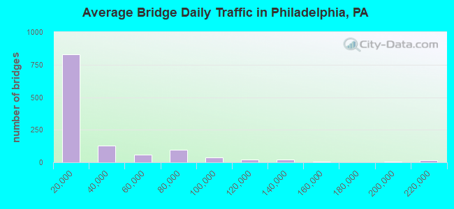
- 32,975,097Total average daily traffic
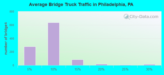
- 2,105,575Total average daily truck traffic
- National Bridge Inventory (NBI) Registered Bridges for Philadelphia
- No street view available for this location
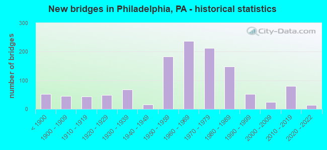
- New bridges - historical statistics
- 53Before 1900
- 451900-1909
- 431910-1919
- 481920-1929
- 681930-1939
- 151940-1949
- 1831950-1959
- 2381960-1969
- 2131970-1979
- 1491980-1989
- 531990-1999
- 252000-2009
- 802010-2019
- 142020-2022
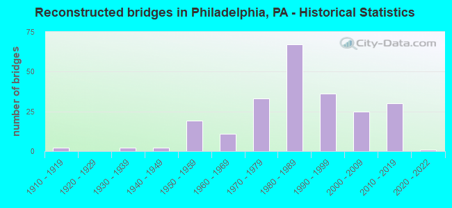
- Reconstructed bridges - Historical Statistics
- 21910-1919
- 01920-1929
- 21930-1939
- 21940-1949
- 191950-1959
- 111960-1969
- 331970-1979
- 671980-1989
- 361990-1999
- 252000-2009
- 302010-2019
- 12020-2022
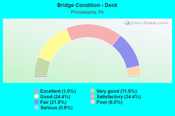
- Bridge Condition - Deck
- 1.0%Excellent
- 11.5%Very good
- 24.4%Good
- 34.4%Satisfactory
- 21.9%Fair
- 6.0%Poor
- 0.9%Serious
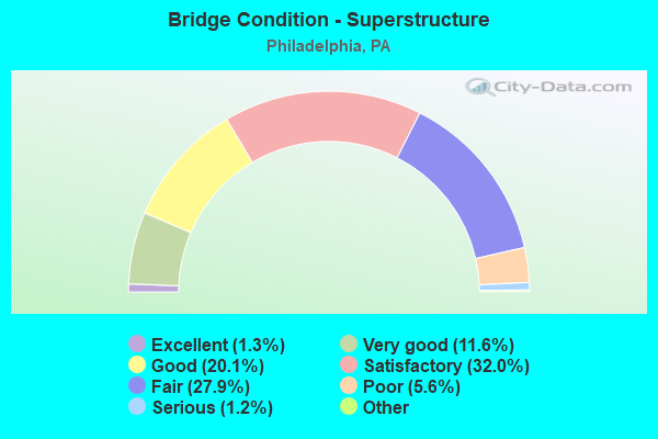
- Bridge Condition - Superstructure
- 1.5%Excellent
- 11.3%Very good
- 18.7%Good
- 32.9%Satisfactory
- 26.6%Fair
- 7.5%Poor
- 1.2%Serious
- 0.3%Imminent failure
- 0.2%Failed
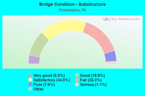
- Bridge Condition - Substructure
- 6.5%Excellent
- 18.9%Very good
- 34.6%Good
- 30.3%Satisfactory
- 7.9%Fair
- 1.1%Poor
- 0.8%Serious
- 0.2%Critical
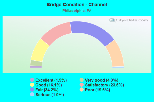
- Bridge Condition - Channel
- 1.5%Excellent
- 4.0%Very good
- 16.1%Good
- 23.6%Satisfactory
- 34.2%Fair
- 19.6%Poor
- 1.0%Serious
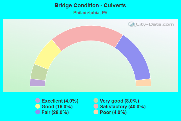
- Bridge Condition - Culverts
- 3.3%Excellent
- 6.7%Very good
- 20.0%Good
- 43.3%Satisfactory
- 23.3%Fair
- 3.3%Poor
Find on map >> Show street view
Structure Number: 39, Location: 4 MI S OF FAIRFIELD (Lat: 39.731617, Lng: -77.365983), Route carried "on" structure: State highway 16, Year Built: 1954, Year Reconstructed: 2010, Status: Open, Structure Length: 4.30m (14.11ft), Average Daily Traffic: 10,608 (year 2022), Truck Traffic: 14%, Average Future Daily Traffic: 12,316 (year 2032), Design Load: HS 20, Features Intersected: TOMS CREEK
Minimum Vertical Clearance: 30+ m (98+ ft), Kilometerpoint: 7.878, Lanes on structure: 2, Owner: State Highway Agency, Approaching Roadway Width: 10.4m (34.1ft), Skew: 6 degrees, Material/Design: Steel, Design/Construction: Stringer/Multi-beam, Number Of Spans In Main Unit: 2, Length of Maximum Span: 20.1m (65.9ft), Curb-To-Curb Width: 11.4m (37.4ft), Out-to-Out Width: 12.4m (40.7ft)
Condition: Deck: Good, Superstructure: Fair, Substructure: Fair, Channel: Satisfactory, Inventory Rating: 67.1 metric tons, Method Used To Determine Inventory Rating: Load Factor (LF), Structural Evaluation: Somewhat better than minimum adequacy, Deck Geometry: Meets minimum limits, Waterway Adequacy: Equal to present minimum criteria, Approach Roadway Alignment: Equal to present desirable criteria, Designated Inspection Frequency: Every 24 months, Inspection Date: December 2020, Deck Structure Type: Concrete Cast-file-Place, Wearing Surface/Protective System: Wearing Surface: Monolithic Concrete, Deck Protection: Epoxy Coated Reinforcing
Find on map >> Show street view
Structure Number: 389, Location: 2.5 E BIGLERV/OPOSSUM CR (Lat: 39.931525, Lng: -77.196850), Route carried "on" structure: City street , Year Built: 1956, Status: Open, Structure Length: 3.23m (10.60ft), Average Daily Traffic: 100 (year 2013), Truck Traffic: 3%, Average Future Daily Traffic: 140 (year 2033), Design Load: HS 20, Features Intersected: OPOSSUM CREEK, Facility Carried by Structure: BENDER CHURCH RD
Minimum Vertical Clearance: 30+ m (98+ ft), Kilometerpoint: 0.000, Lanes on structure: 1, Owner: County Highway Agency, Approaching Roadway Width: 5.5m (18.0ft), Material/Design: Prestressed concrete, Design/Construction: Box Beam or Girders - Multiple, Number Of Spans In Main Unit: 2, Length of Maximum Span: 15.5m (50.9ft), Curb or Sidewalk Widths: Left: 0.2m (0.7ft), Right: 0.2m (0.7ft), Curb-To-Curb Width: 5.1m (16.7ft), Out-to-Out Width: 5.5m (18.0ft)
Condition: Deck: Fair, Superstructure: Fair, Substructure: Satisfactory, Channel: Fair, Operating Rating: 68.0 metric tons, Method Used To Determine Operating Rating: Load and Resistance Factor (LRFR), Inventory Rating: 50.8 metric tons, Method Used To Determine Inventory Rating: Load and Resistance Factor (LRFR), Structural Evaluation: Somewhat better than minimum adequacy, Deck Geometry: High priority of corrective action, Waterway Adequacy: Better than present minimum criteria, Approach Roadway Alignment: Equal to present desirable criteria, Length Of Structure Improvement: 3.80m (12.47ft), Designated Inspection Frequency: Every 24 months, Inspection Date: July 2021, Deck Structure Type: Other, Wearing Surface/Protective System: Wearing Surface: Bituminous, Membrane: Preformed Fabric
Find on map >> Show street view
Structure Number: 393, Location: 2.5 MI.E OF BIGLERVILLE (Lat: 39.927894, Lng: -77.189922), Route carried "on" structure: City street , Year Built: 1991, Status: Open, Structure Length: 2.41m (7.91ft), Average Daily Traffic: 300 (year 2009), Truck Traffic: 3%, Average Future Daily Traffic: 420 (year 2030), Features Intersected: CONEWAGO CREEK, Facility Carried by Structure: STONE JUG ROAD
Minimum Vertical Clearance: 30+ m (98+ ft), Kilometerpoint: 0.000, Lanes on structure: 2, Owner: County Highway Agency, Approaching Roadway Width: 7.9m (25.9ft), Skew: 1 degrees, Material/Design: Prestressed concrete continuous, Design/Construction: Box Beam or Girders - Single/Spread, Number Of Spans In Main Unit: 2, Length of Maximum Span: 11.9m (39.0ft), Curb or Sidewalk Widths: Left: 0.2m (0.7ft), Right: 0.2m (0.7ft), Curb-To-Curb Width: 7.9m (25.9ft), Out-to-Out Width: 9.0m (29.5ft)
Condition: Deck: Good, Superstructure: Good, Substructure: Good, Channel: Good, Operating Rating: 68.9 metric tons, Method Used To Determine Operating Rating: Load Factor (LF), Inventory Rating: 40.8 metric tons, Method Used To Determine Inventory Rating: Load Factor (LF), Structural Evaluation: Better than present minimum criteria, Deck Geometry: Somewhat better than minimum adequacy, Waterway Adequacy: Equal to present minimum criteria, Approach Roadway Alignment: Better than present minimum criteria, Length Of Structure Improvement: 3.10m (10.17ft), Designated Inspection Frequency: Every 24 months, Inspection Date: July 2021, Deck Structure Type: Concrete Cast-file-Place, Wearing Surface/Protective System: Wearing Surface: Monolithic Concrete, Membrane: Epoxy, Deck Protection: Epoxy Coated Reinforcing
Find on map >> Show street view
Structure Number: 394, Location: 2.5 MI.EBIGVLELERVILLE/OP (Lat: 39.929461, Lng: -77.192267), Route carried "on" structure: City street , Year Built: 1983, Status: Open, Structure Length: 2.26m (7.41ft), Average Daily Traffic: 300 (year 2009), Truck Traffic: 5%, Average Future Daily Traffic: 420 (year 2030), Design Load: HS 20, Features Intersected: OPOSSUM CREEK, Facility Carried by Structure: STONE JUG ROAD
Minimum Vertical Clearance: 30+ m (98+ ft), Kilometerpoint: 0.000, Lanes on structure: 2, Owner: County Highway Agency, Approaching Roadway Width: 5.8m (19.0ft), Skew: 3 degrees, Material/Design: Prestressed concrete, Design/Construction: Box Beam or Girders - Multiple, Number Of Spans In Main Unit: 1, Length of Maximum Span: 21.9m (71.9ft), Curb or Sidewalk Widths: Left: 0.2m (0.7ft), Right: 0.2m (0.7ft), Curb-To-Curb Width: 7.9m (25.9ft), Out-to-Out Width: 9.0m (29.5ft)
Condition: Deck: Satisfactory, Superstructure: Satisfactory, Substructure: Good, Channel: Fair, Operating Rating: 43.5 metric tons, Method Used To Determine Operating Rating: Load and Resistance Factor (LRFR), Inventory Rating: 14.5 metric tons, Method Used To Determine Inventory Rating: Load and Resistance Factor (LRFR), Structural Evaluation: Meets minimum limits, Deck Geometry: Somewhat better than minimum adequacy, Waterway Adequacy: Equal to present minimum criteria, Approach Roadway Alignment: Equal to present desirable criteria, Length Of Structure Improvement: 3.00m (9.84ft), Designated Inspection Frequency: Every 24 months, Inspection Date: July 2021, Deck Structure Type: Other, Wearing Surface/Protective System: Wearing Surface: Bituminous, Membrane: Preformed Fabric
Find on map >> Show street view
Structure Number: 547, Location: 761'E.OF WASH.CO.LINE (Lat: 40.426886, Lng: -80.294628), Route carried "on" structure: US 22, Year Built: 1964, Status: Open, Structure Length: 7.92m (25.98ft), Average Daily Traffic: 22,738 (year 2022), Truck Traffic: 17%, Average Future Daily Traffic: 30,626 (year 2032), Design Load: HS 20, Features Intersected: POTATO GARDEN RD.
Minimum Vertical Clearance: 30+ m (98+ ft), Kilometerpoint: 0.000, Lanes on structure: 4, Lanes under structure: 2, Base Highway Network: Yes, Owner: State Highway Agency, Approaching Roadway Width: 18.3m (60.0ft), Skew: 22 degrees, Material/Design: Prestressed concrete, Design/Construction: Box Beam or Girders - Single/Spread, Number Of Spans In Main Unit: 4, Length of Maximum Span: 19.8m (65.0ft), Curb or Sidewalk Widths: Left: 0.2m (0.7ft), Right: 0.2m (0.7ft), Curb-To-Curb Width: 18.3m (60.0ft), Out-to-Out Width: 19.5m (64.0ft)
Condition: Deck: Satisfactory, Superstructure: Satisfactory, Substructure: Satisfactory, Operating Rating: 68.0 metric tons, Method Used To Determine Operating Rating: Load Factor (LF), Inventory Rating: 40.8 metric tons, Method Used To Determine Inventory Rating: Load Factor (LF), Structural Evaluation: Equal to present minimum criteria, Deck Geometry: Somewhat better than minimum adequacy, Underclear: Somewhat better than minimum adequacy, Approach Roadway Alignment: Equal to present desirable criteria, Length Of Structure Improvement: 7.90m (25.92ft), Designated Inspection Frequency: Every 24 months, Inspection Date: October 2020, Bridge Improvement Cost: $78,000, Roadway Improvement Cost: $229,000, Total Project Cost: $1,050,000, Deck Structure Type: Concrete Cast-file-Place, Wearing Surface/Protective System: Wearing Surface: Latex Concrete, Deck Protection: Epoxy Coated Reinforcing
Find on map >> Show street view
Structure Number: 3838, Location: 300' W of TUSCARAWAS RD (Lat: 40.693106, Lng: -80.317967), Route carried "on" structure: City street , Year Built: 1941, Status: Open, Structure Length: 0.85m (2.79ft), Average Daily Traffic: 2,831 (year 2021), Truck Traffic: 1%, Average Future Daily Traffic: 2,831 (year 2043), Design Load: HS 20, Features Intersected: TWO MILE RUN, Facility Carried by Structure: GEORGETOWN LN
Minimum Vertical Clearance: 30+ m (98+ ft), Kilometerpoint: 0.000, Lanes on structure: 2, Owner: Town or Township Highway Agency, Approaching Roadway Width: 7.3m (24.0ft), Skew: 2 degrees, Material/Design: Concrete, Design/Construction: Tee Beam, Number Of Spans In Main Unit: 1, Length of Maximum Span: 7.3m (24.0ft), Curb-To-Curb Width: 6.8m (22.3ft), Out-to-Out Width: 7.9m (25.9ft)
Condition: Deck: Fair, Superstructure: Fair, Substructure: Fair, Channel: Satisfactory, Operating Rating: 77.1 metric tons, Method Used To Determine Operating Rating: Load Factor (LF), Inventory Rating: 46.3 metric tons, Method Used To Determine Inventory Rating: Load Factor (LF), Structural Evaluation: Somewhat better than minimum adequacy, Deck Geometry: High priority of replacement, Waterway Adequacy: Equal to present minimum criteria, Approach Roadway Alignment: Equal to present desirable criteria, Length Of Structure Improvement: 0.90m (2.95ft), Designated Inspection Frequency: Every 24 months, Inspection Date: October 2021, Bridge Improvement Cost: $20,000, Roadway Improvement Cost: $60,000, Total Project Cost: $275,000, Deck Structure Type: Concrete Cast-file-Place, Wearing Surface/Protective System: Wearing Surface: Bituminous
Find on map >> Show street view
Structure Number: 3839, Location: 101007 1MI W/TUSCARAWAS R (Lat: 40.690267, Lng: -80.322681), Route carried "on" structure: City street , Year Built: 1941, Status: Open, Structure Length: 1.04m (3.41ft), Average Daily Traffic: 3,160 (year 2021), Truck Traffic: 5%, Average Future Daily Traffic: 3,160 (year 2043), Design Load: HS 20, Features Intersected: TWO MILE RUN, Facility Carried by Structure: GEORGETOWN LN
Minimum Vertical Clearance: 30+ m (98+ ft), Kilometerpoint: 0.000, Lanes on structure: 2, Owner: Town or Township Highway Agency, Approaching Roadway Width: 6.4m (21.0ft), Skew: 1 degrees, Material/Design: Concrete, Design/Construction: Tee Beam, Number Of Spans In Main Unit: 1, Length of Maximum Span: 9.1m (29.9ft), Curb-To-Curb Width: 6.8m (22.3ft), Out-to-Out Width: 7.8m (25.6ft)
Condition: Deck: Satisfactory, Superstructure: Fair, Substructure: Fair, Channel: Fair, Operating Rating: 65.3 metric tons, Method Used To Determine Operating Rating: Load Factor (LF), Inventory Rating: 39.0 metric tons, Method Used To Determine Inventory Rating: Load Factor (LF), Structural Evaluation: Somewhat better than minimum adequacy, Deck Geometry: High priority of replacement, Waterway Adequacy: Equal to present minimum criteria, Approach Roadway Alignment: Equal to present desirable criteria, Length Of Structure Improvement: 1.00m (3.28ft), Designated Inspection Frequency: Every 24 months, Inspection Date: October 2021, Bridge Improvement Cost: $21,000, Roadway Improvement Cost: $63,000, Total Project Cost: $288,000, Deck Structure Type: Concrete Cast-file-Place, Wearing Surface/Protective System: Wearing Surface: Bituminous
Find on map >> Show street view
Structure Number: 3845, Location: 004054 100' S/MCKINLY INT (Lat: 40.711100, Lng: -80.284794), Route carried "on" structure: City street , Year Built: 1905, Status: Open, Structure Length: 0.61m (2.00ft), Average Daily Traffic: 520 (year 2019), Truck Traffic: 1%, Average Future Daily Traffic: 630 (year 2041), Features Intersected: MCKINLEY RUN, Facility Carried by Structure: Pennsylvania Ave
Minimum Vertical Clearance: 30+ m (98+ ft), Kilometerpoint: 0.000, Lanes on structure: 2, Owner: County Highway Agency, Approaching Roadway Width: 7.3m (24.0ft), Material/Design: Masonry, Design/Construction: Arch - Deck, Number Of Spans In Main Unit: 1, Length of Maximum Span: 6.1m (20.0ft), Curb or Sidewalk Widths: Left: 1.0m (3.3ft), Right: 2.3m (7.5ft), Curb-To-Curb Width: 8.1m (26.6ft), Out-to-Out Width: 12.2m (40.0ft)
Condition: Superstructure: Fair, Substructure: Good, Channel: Good, Operating Rating: 32.7 metric tons, Method Used To Determine Operating Rating: Field evaluation and documented engineering judgment, Inventory Rating: 21.8 metric tons, Method Used To Determine Inventory Rating: Field evaluation and documented engineering judgment, Structural Evaluation: Somewhat better than minimum adequacy, Deck Geometry: Somewhat better than minimum adequacy, Waterway Adequacy: Superior to present desirable criteria, Approach Roadway Alignment: Equal to present desirable criteria, Length Of Structure Improvement: 0.60m (1.97ft), Designated Inspection Frequency: Every 24 months, Inspection Date: April 2021, Bridge Improvement Cost: $5,000, Roadway Improvement Cost: $31,000, Total Project Cost: $64,000
Find on map >> Show street view
Structure Number: 3846, Location: 004046 INTER T521&SR 1035 (Lat: 40.709153, Lng: -80.249611), Route carried "on" structure: City street , Year Built: 1988, Status: Open, Structure Length: 1.01m (3.31ft), Average Daily Traffic: 150 (year 2019), Truck Traffic: 2%, Average Future Daily Traffic: 150 (year 2041), Design Load: HS 20, Features Intersected: DUTCHMANS RUN, Facility Carried by Structure: SPADE RD
Minimum Vertical Clearance: 30+ m (98+ ft), Kilometerpoint: 0.000, Lanes on structure: 2, Owner: County Highway Agency, Approaching Roadway Width: 7.3m (24.0ft), Skew: 2 degrees, Material/Design: Steel, Design/Construction: Stringer/Multi-beam, Number Of Spans In Main Unit: 1, Length of Maximum Span: 9.1m (29.9ft), Curb or Sidewalk Widths: Left: 0.2m (0.7ft), Right: 0.2m (0.7ft), Curb-To-Curb Width: 7.3m (24.0ft), Out-to-Out Width: 8.4m (27.6ft)
Condition: Deck: Good, Superstructure: Good, Substructure: Fair, Channel: Poor, Operating Rating: 85.3 metric tons, Method Used To Determine Operating Rating: Load Factor (LF), Inventory Rating: 50.8 metric tons, Method Used To Determine Inventory Rating: Load Factor (LF), Structural Evaluation: Somewhat better than minimum adequacy, Deck Geometry: Somewhat better than minimum adequacy, Waterway Adequacy: Superior to present desirable criteria, Approach Roadway Alignment: Equal to present minimum criteria, Length Of Structure Improvement: 0.90m (2.95ft), Designated Inspection Frequency: Every 24 months, Critical Feature Inspection Frequency: Every 24 months, Inspection Date: April 2021, Critical Feature Inspection Date: April 2021, Deck Structure Type: Concrete Cast-file-Place, Wearing Surface/Protective System: Wearing Surface: Monolithic Concrete, Deck Protection: Epoxy Coated Reinforcing
Find on map >> Show street view
Structure Number: 3856, Location: 004015 BAKERS LANDING BRG (Lat: 40.671331, Lng: -80.262564), Route carried "on" structure: City street , Year Built: 1989, Year Reconstructed: 2017, Status: Open, Structure Length: 1.01m (3.31ft), Average Daily Traffic: 100 (year 2019), Truck Traffic: 2%, Average Future Daily Traffic: 154 (year 2041), Design Load: HS 20, Features Intersected: ELKHORN RUN, Facility Carried by Structure: ELKHORN RD
Minimum Vertical Clearance: 30+ m (98+ ft), Kilometerpoint: 0.000, Lanes on structure: 2, Owner: County Highway Agency, Approaching Roadway Width: 4.0m (13.1ft), Material/Design: Prestressed concrete, Design/Construction: Box Beam or Girders - Multiple, Number Of Spans In Main Unit: 1, Length of Maximum Span: 9.8m (32.2ft), Curb or Sidewalk Widths: Left: 0.2m (0.7ft), Right: 0.2m (0.7ft), Curb-To-Curb Width: 7.6m (24.9ft), Out-to-Out Width: 8.7m (28.5ft)
Condition: Deck: Very good, Superstructure: Good, Substructure: Good, Channel: Satisfactory, Inventory Rating: 61.7 metric tons, Method Used To Determine Inventory Rating: Load Factor (LF), Structural Evaluation: Better than present minimum criteria, Deck Geometry: Equal to present minimum criteria, Waterway Adequacy: Superior to present desirable criteria, Approach Roadway Alignment: Equal to present desirable criteria, Length Of Structure Improvement: 1.00m (3.28ft), Designated Inspection Frequency: Every 24 months, Inspection Date: October 2021, Wearing Surface/Protective System: Wearing Surface: Monolithic Concrete, Deck Protection: Epoxy Coated Reinforcing
Find on map >> Show street view
Structure Number: 3858, Location: 004025 1300' E/N CAMP RUN (Lat: 40.841861, Lng: -80.179156), Route carried "on" structure: City street , Year Built: 1887, Year Reconstructed: 1958, Status: Open, Structure Length: 1.01m (3.31ft), Average Daily Traffic: 80 (year 2017), Truck Traffic: 5%, Average Future Daily Traffic: 100 (year 2039), Design Load: HS 20, Features Intersected: CAMP RUN, Facility Carried by Structure: AMERICAN SCHOOL RD
Minimum Vertical Clearance: 30+ m (98+ ft), Kilometerpoint: 0.000, Lanes on structure: 2, Owner: County Highway Agency, Approaching Roadway Width: 3.7m (12.1ft), Material/Design: Steel, Design/Construction: Stringer/Multi-beam, Number Of Spans In Main Unit: 1, Length of Maximum Span: 9.8m (32.2ft), Curb-To-Curb Width: 4.9m (16.1ft), Out-to-Out Width: 5.0m (16.4ft)
Condition: Deck: Fair, Superstructure: Fair, Substructure: Fair, Channel: Fair, Operating Rating: 88.9 metric tons, Method Used To Determine Operating Rating: Load Factor (LF), Inventory Rating: 53.5 metric tons, Method Used To Determine Inventory Rating: Load Factor (LF), Structural Evaluation: Somewhat better than minimum adequacy, Waterway Adequacy: Better than present minimum criteria, Approach Roadway Alignment: Equal to present minimum criteria, Length Of Structure Improvement: 1.00m (3.28ft), Designated Inspection Frequency: Every 24 months, Inspection Date: June 2021, Bridge Improvement Cost: $16,000, Roadway Improvement Cost: $49,000, Total Project Cost: $213,000, Deck Structure Type: Concrete Cast-file-Place, Wearing Surface/Protective System: Wearing Surface: Bituminous
Find on map >> Show street view
Structure Number: 3865, Location: 004042 OVER SERVICE CREEK (Lat: 40.583103, Lng: -80.318728), Route carried "on" structure: City street , Year Built: 1982, Status: Open, Structure Length: 1.01m (3.31ft), Average Daily Traffic: 70 (year 2019), Truck Traffic: 5%, Average Future Daily Traffic: 70 (year 2041), Design Load: HS 20, Features Intersected: SERVICE CREEK, Facility Carried by Structure: PARISH RD
Minimum Vertical Clearance: 30+ m (98+ ft), Kilometerpoint: 0.000, Lanes on structure: 2, Owner: County Highway Agency, Approaching Roadway Width: 4.9m (16.1ft), Material/Design: Steel, Design/Construction: Culvert, Number Of Spans In Main Unit: 1, Length of Maximum Span: 10.1m (33.1ft)
Condition: Channel: Fair, Culverts: Satisfactory, Operating Rating: 49.0 metric tons, Method Used To Determine Operating Rating: Field evaluation and documented engineering judgment, Inventory Rating: 32.7 metric tons, Method Used To Determine Inventory Rating: Field evaluation and documented engineering judgment, Structural Evaluation: Equal to present minimum criteria, Waterway Adequacy: Superior to present desirable criteria, Approach Roadway Alignment: Equal to present desirable criteria, Length Of Structure Improvement: 1.00m (3.28ft), Designated Inspection Frequency: Every 24 months, Inspection Date: October 2021
Find on map >> Show street view
Structure Number: 3866, Location: 004037 1 MI S OF RT 151 (Lat: 40.533850, Lng: -80.325842), Route carried "on" structure: City street , Year Built: 1982, Status: Open, Structure Length: 3.05m (10.01ft), Average Daily Traffic: 150 (year 2019), Truck Traffic: 10%, Average Future Daily Traffic: 230 (year 2041), Design Load: HS 20, Features Intersected: RACCOON CREEK, Facility Carried by Structure: SCHOOL RD
Minimum Vertical Clearance: 30+ m (98+ ft), Kilometerpoint: 0.000, Lanes on structure: 2, Owner: County Highway Agency, Approaching Roadway Width: 4.9m (16.1ft), Material/Design: Steel, Design/Construction: Stringer/Multi-beam, Number Of Spans In Main Unit: 1, Length of Maximum Span: 28.7m (94.2ft), Curb-To-Curb Width: 7.4m (24.3ft), Out-to-Out Width: 7.9m (25.9ft)
Condition: Deck: Good, Superstructure: Good, Substructure: Good, Channel: Good, Operating Rating: 77.1 metric tons, Method Used To Determine Operating Rating: Load Factor (LF), Inventory Rating: 46.3 metric tons, Method Used To Determine Inventory Rating: Load Factor (LF), Structural Evaluation: Better than present minimum criteria, Deck Geometry: Somewhat better than minimum adequacy, Waterway Adequacy: Equal to present desirable criteria, Approach Roadway Alignment: Meets minimum limits, Length Of Structure Improvement: 3.00m (9.84ft), Designated Inspection Frequency: Every 24 months, Inspection Date: October 2021, Deck Structure Type: Concrete Cast-file-Place, Wearing Surface/Protective System: Wearing Surface: Monolithic Concrete, Deck Protection: Epoxy Coated Reinforcing
Find on map >> Show street view
Structure Number: 3872, Location: 004033 N/RT 151 &BOCKTOWN (Lat: 40.552161, Lng: -80.303822), Route carried "on" structure: City street , Year Built: 1916, Year Reconstructed: 1979, Status: Open, Structure Length: 3.44m (11.29ft), Average Daily Traffic: 50 (year 2019), Truck Traffic: 5%, Average Future Daily Traffic: 50 (year 2041), Design Load: HS 15, Features Intersected: RACCOON CREEK, Facility Carried by Structure: TWP RT819 RIDGE RD
Minimum Vertical Clearance: 30+ m (98+ ft), Kilometerpoint: 0.000, Lanes on structure: 2, Owner: County Highway Agency, Approaching Roadway Width: 4.6m (15.1ft), Material/Design: Steel, Design/Construction: Stringer/Multi-beam, Number Of Spans In Main Unit: 1, Length of Maximum Span: 33.2m (108.9ft), Curb-To-Curb Width: 6.2m (20.3ft), Out-to-Out Width: 6.7m (22.0ft)
Condition: Deck: Satisfactory, Superstructure: Good, Substructure: Fair, Channel: Fair, Operating Rating: 78.0 metric tons, Method Used To Determine Operating Rating: Load Factor (LF), Inventory Rating: 47.2 metric tons, Method Used To Determine Inventory Rating: Load Factor (LF), Structural Evaluation: Somewhat better than minimum adequacy, Deck Geometry: Somewhat better than minimum adequacy, Waterway Adequacy: Equal to present desirable criteria, Approach Roadway Alignment: Somewhat better than minimum adequacy, Length Of Structure Improvement: 3.40m (11.15ft), Designated Inspection Frequency: Every 24 months, Critical Feature Inspection Frequency: Every 24 months, Inspection Date: October 2021, Critical Feature Inspection Date: October 2021, Deck Structure Type: Concrete Cast-file-Place, Wearing Surface/Protective System: Wearing Surface: Monolithic Concrete, Deck Protection: Epoxy Coated Reinforcing
Find on map >> Show street view
Structure Number: 3873, Location: P02302 OLD FURNACE/WESTRD (Lat: 40.796900, Lng: -80.167597), Route carried "on" structure: City street , Year Built: 1939, Status: Posted for load, Structure Length: 2.87m (9.42ft), Average Daily Traffic: 10 (year 2016), Truck Traffic: 1%, Average Future Daily Traffic: 10 (year 2038), Design Load: HS 20, Features Intersected: CSX RR, Facility Carried by Structure: OLD FURNACE/WST RD
Minimum Vertical Clearance: 30+ m (98+ ft), Kilometerpoint: 0.000, Lanes on structure: 1, Owner: Railroad, Approaching Roadway Width: 2.4m (7.9ft), Material/Design: Steel, Design/Construction: Stringer/Multi-beam, Number Of Spans In Main Unit: 1, Number Of Approach Spans: 4, Length of Maximum Span: 10.7m (35.1ft), Curb or Sidewalk Widths: Left: 0.2m (0.7ft), Right: 0.2m (0.7ft), Curb-To-Curb Width: 3.9m (12.8ft), Out-to-Out Width: 4.2m (13.8ft)
Condition: Deck: Fair, Superstructure: Fair, Substructure: Poor, Operating Rating: 9.1 metric tons, Method Used To Determine Operating Rating: Allowable Stress (AS), Inventory Rating: 5.4 metric tons, Method Used To Determine Inventory Rating: Allowable Stress (AS), Structural Evaluation: High priority of replacement, Deck Geometry: Meets minimum limits, Underclear: High priority of replacement, Approach Roadway Alignment: Meets minimum limits, Bridge Posting: Required (Relationship of Operating Rating to Maximum Legal Load: > 39.9% below), Length Of Structure Improvement: 3.00m (9.84ft), Designated Inspection Frequency: Every 24 months, Other Special Inspection Frequency: Every 6 months, Inspection Date: October 2020, Other Special Inspection Date: October 2021, Bridge Improvement Cost: $17,000, Roadway Improvement Cost: $52,000, Total Project Cost: $230,000, Deck Structure Type: Wood or Timber, Wearing Surface/Protective System: Wearing Surface: Wood or Timber
Find on map >> Show street view
Structure Number: 3876, Location: 004044 HARKINS MILL BRDG (Lat: 40.728539, Lng: -80.164997), Route carried "on" structure: City street , Year Built: 1988, Year Reconstructed: 2017, Status: Open, Structure Length: 2.19m (7.19ft), Average Daily Traffic: 150 (year 2019), Truck Traffic: 7%, Average Future Daily Traffic: 175 (year 2041), Design Load: HS 20, Features Intersected: BRUSH CREEK, Facility Carried by Structure: HARKINS MILL RD
Minimum Vertical Clearance: 30+ m (98+ ft), Kilometerpoint: 0.000, Lanes on structure: 2, Owner: County Highway Agency, Approaching Roadway Width: 7.3m (24.0ft), Skew: 3 degrees, Material/Design: Prestressed concrete, Design/Construction: Box Beam or Girders - Multiple, Number Of Spans In Main Unit: 1, Length of Maximum Span: 21.3m (69.9ft), Curb or Sidewalk Widths: Left: 0.2m (0.7ft), Right: 0.2m (0.7ft), Curb-To-Curb Width: 7.6m (24.9ft), Out-to-Out Width: 8.6m (28.2ft)
Condition: Deck: Good, Superstructure: Good, Substructure: Good, Channel: Satisfactory, Operating Rating: 67.1 metric tons, Method Used To Determine Operating Rating: Load Factor (LF), Inventory Rating: 22.7 metric tons, Method Used To Determine Inventory Rating: Load Factor (LF), Structural Evaluation: Equal to present minimum criteria, Deck Geometry: Somewhat better than minimum adequacy, Waterway Adequacy: Superior to present desirable criteria, Approach Roadway Alignment: Equal to present desirable criteria, Length Of Structure Improvement: 2.20m (7.22ft), Designated Inspection Frequency: Every 24 months, Inspection Date: Febuary 2021, Wearing Surface/Protective System: Wearing Surface: Monolithic Concrete, Deck Protection: Epoxy Coated Reinforcing
Find on map >> Show street view
Structure Number: 3878, Location: 004047 NEW SEWICKLEY TWP (Lat: 40.740122, Lng: -80.199950), Route carried "on" structure: City street , Year Built: 1982, Status: Open, Structure Length: 2.23m (7.32ft), Average Daily Traffic: 73 (year 2019), Truck Traffic: 5%, Average Future Daily Traffic: 80 (year 2041), Design Load: HS 20, Features Intersected: BRUSH CREEK, Facility Carried by Structure: WHITES HILL ROAD
Minimum Vertical Clearance: 30+ m (98+ ft), Kilometerpoint: 0.000, Lanes on structure: 2, Owner: County Highway Agency, Approaching Roadway Width: 5.2m (17.1ft), Material/Design: Steel, Design/Construction: Stringer/Multi-beam, Number Of Spans In Main Unit: 1, Length of Maximum Span: 20.7m (67.9ft), Curb or Sidewalk Widths: Left: 0.2m (0.7ft), Right: 0.2m (0.7ft), Curb-To-Curb Width: 8.5m (27.9ft), Out-to-Out Width: 9.6m (31.5ft)
Condition: Deck: Satisfactory, Superstructure: Good, Substructure: Satisfactory, Channel: Fair, Operating Rating: 80.7 metric tons, Method Used To Determine Operating Rating: Load Factor (LF), Inventory Rating: 48.1 metric tons, Method Used To Determine Inventory Rating: Load Factor (LF), Structural Evaluation: Equal to present minimum criteria, Deck Geometry: Better than present minimum criteria, Waterway Adequacy: Better than present minimum criteria, Approach Roadway Alignment: Meets minimum limits, Length Of Structure Improvement: 2.10m (6.89ft), Designated Inspection Frequency: Every 24 months, Inspection Date: October 2021, Bridge Improvement Cost: $5,000, Roadway Improvement Cost: $25,000, Total Project Cost: $65,000, Deck Structure Type: Concrete Cast-file-Place, Wearing Surface/Protective System: Wearing Surface: Monolithic Concrete, Deck Protection: Epoxy Coated Reinforcing
Find on map >> Show street view
Structure Number: 3883, Location: 004055 STATE LINE RD (Lat: 40.765122, Lng: -80.504694), Route carried "on" structure: City street , Year Built: 1929, Year Reconstructed: 2019, Status: Open, Structure Length: 1.34m (4.40ft), Average Daily Traffic: 75 (year 2019), Truck Traffic: 5%, Average Future Daily Traffic: 85 (year 2041), Design Load: HS 20, Features Intersected: BRUSH RUN, Facility Carried by Structure: STATE LINE RD
Minimum Vertical Clearance: 30+ m (98+ ft), Kilometerpoint: 0.000, Lanes on structure: 2, Owner: County Highway Agency, Approaching Roadway Width: 4.9m (16.1ft), Material/Design: Steel, Design/Construction: Truss - Thru, Number Of Spans In Main Unit: 1, Length of Maximum Span: 12.2m (40.0ft), Curb or Sidewalk Widths: Left: 0.2m (0.7ft), Right: 0.2m (0.7ft), Curb-To-Curb Width: 4.9m (16.1ft), Out-to-Out Width: 5.2m (17.1ft)
Condition: Deck: Good, Superstructure: Good, Substructure: Good, Channel: Fair, Operating Rating: 46.3 metric tons, Method Used To Determine Operating Rating: Load Factor (LF), Inventory Rating: 28.1 metric tons, Method Used To Determine Inventory Rating: Load Factor (LF), Structural Evaluation: Better than present minimum criteria, Deck Geometry: High priority of corrective action, Waterway Adequacy: Better than present minimum criteria, Approach Roadway Alignment: Meets minimum limits, Length Of Structure Improvement: 1.30m (4.27ft), Designated Inspection Frequency: Every 24 months, Critical Feature Inspection Frequency: Every 24 months, Inspection Date: November 2019, Critical Feature Inspection Date: November 2019, Bridge Improvement Cost: $20,000, Roadway Improvement Cost: $60,000, Total Project Cost: $275,000, Deck Structure Type: Concrete Cast-file-Place, Wearing Surface/Protective System: Wearing Surface: Monolithic Concrete, Deck Protection: Epoxy Coated Reinforcing
Find on map >> Show street view
Structure Number: 3894, Location: AMBRIDGE-ALIQUIPPA SP 2-9 (Lat: 40.592317, Lng: -80.237189), Route carried "on" structure: City street , Year Built: 1927, Year Reconstructed: 2013, Status: Posted for load, Structure Length: 58.13m (190.72ft), Average Daily Traffic: 22,500 (year 2019), Truck Traffic: 9%, Average Future Daily Traffic: 25,000 (year 2041), Design Load: HS 20, Features Intersected: OHIO RIVER, 2 RR, Facility Carried by Structure: AMBRIDGE-ALIQ BR
Minimum Vertical Clearance: 6.07m (19.91ft), Kilometerpoint: 0.000, Lanes on structure: 2, Lanes under structure: 2, Owner: County Highway Agency, Approaching Roadway Width: 11.0m (36.1ft), Navigation Control: Yes ( Vertical Clearance: 23.8m (78.1ft), Horizontal Clearance: 23.8m (78.1ft)), Material/Design: Steel continuous, Design/Construction: Truss - Thru, Number Of Spans In Main Unit: 5, Number Of Approach Spans: 3, Length of Maximum Span: 161.5m (529.9ft), Curb or Sidewalk Widths: Left: 0.0m, Right: 2.7m (8.9ft), Curb-To-Curb Width: 7.6m (24.9ft), Out-to-Out Width: 8.2m (26.9ft)
Condition: Deck: Good, Superstructure: Fair, Substructure: Fair, Channel: Satisfactory, Operating Rating: 32.7 metric tons, Method Used To Determine Operating Rating: Load Factor (LF), Inventory Rating: 14.5 metric tons, Method Used To Determine Inventory Rating: Load Factor (LF), Structural Evaluation: High priority of corrective action, Deck Geometry: High priority of replacement, Underclear: High priority of corrective action, Waterway Adequacy: Superior to present desirable criteria, Approach Roadway Alignment: Equal to present desirable criteria, Bridge Posting: Required (Relationship of Operating Rating to Maximum Legal Load: 10.0 - 19.9% below), Length Of Structure Improvement: 60.80m (199.48ft), Designated Inspection Frequency: Every 24 months, Critical Feature Inspection Frequency: Every 12 months, Underwater Inspection Frequency: Every 60 months, Other Special Inspection Frequency: Every 12 months, Inspection Date: August 2019, Critical Feature Inspection Date: August 2020, Underwater Inspection Date: June 2021, Other Special Inspection Date: August 2020, Bridge Improvement Cost: $1,472,000, Roadway Improvement Cost: $4,336,000, Total Project Cost: $19,875,000, Deck Structure Type: Concrete Cast-file-Place, Wearing Surface/Protective System: Wearing Surface: Monolithic Concrete, Deck Protection: Epoxy Coated Reinforcing
Find on map >> Show street view
Structure Number: 3905, Location: 423005 100 YD /13 ST INT (Lat: 40.732253, Lng: -80.303658), Route carried "on" structure: City street , Year Built: 1925, Status: Closed, Structure Length: 1.40m (4.59ft), Features Intersected: BLOCKHOUSE RUN, Facility Carried by Structure: ELEVENTH AVENUE ET
Minimum Vertical Clearance: 30+ m (98+ ft), Kilometerpoint: 0.000, Lanes on structure: 1, Owner: City or Municipal Highway Agency, Approaching Roadway Width: 4.0m (13.1ft), Skew: 3 degrees, Material/Design: Steel, Design/Construction: Girder and Floorbeam System, Number Of Spans In Main Unit: 1, Length of Maximum Span: 12.5m (41.0ft), Curb-To-Curb Width: 4.0m (13.1ft), Out-to-Out Width: 5.1m (16.7ft)
Condition: Deck: Poor, Superstructure: Failed, Substructure: Satisfactory, Channel: Fair, Deck Geometry: Somewhat better than minimum adequacy, Waterway Adequacy: Better than present minimum criteria, Approach Roadway Alignment: Somewhat better than minimum adequacy, Bridge Posting: Required (Relationship of Operating Rating to Maximum Legal Load: > 39.9% below), Length Of Structure Improvement: 1.40m (4.59ft), Designated Inspection Frequency: Every 24 months, Inspection Date: April 2020, Bridge Improvement Cost: $50,000, Roadway Improvement Cost: $150,000, Total Project Cost: $800,000, Deck Structure Type: Concrete Cast-file-Place, Wearing Surface/Protective System: Wearing Surface: Bituminous
Find on map >> Show street view
Structure Number: 3906, Location: 423006 100 YD / 13 ST INT (Lat: 40.732258, Lng: -80.303647), Route carried "on" structure: City street , Year Built: 1905, Year Reconstructed: 1993, Status: Open, Structure Length: 1.55m (5.09ft), Average Daily Traffic: 50 (year 2019), Truck Traffic: 10%, Average Future Daily Traffic: 73 (year 2041), Design Load: HS 20, Features Intersected: BLOCKHOUSE RUN, Facility Carried by Structure: ELEVENTH AVENUE ET
Minimum Vertical Clearance: 30+ m (98+ ft), Kilometerpoint: 0.000, Lanes on structure: 1, Owner: City or Municipal Highway Agency, Approaching Roadway Width: 4.9m (16.1ft), Material/Design: Steel, Design/Construction: Girder and Floorbeam System, Number Of Spans In Main Unit: 1, Length of Maximum Span: 13.1m (43.0ft), Curb or Sidewalk Widths: Left: 0.1m (0.3ft), Right: 0.1m (0.3ft), Curb-To-Curb Width: 3.4m (11.2ft), Out-to-Out Width: 4.0m (13.1ft)
Condition: Deck: Good, Superstructure: Fair, Substructure: Satisfactory, Channel: Poor, Operating Rating: 75.3 metric tons, Method Used To Determine Operating Rating: Load Factor (LF), Inventory Rating: 45.4 metric tons, Method Used To Determine Inventory Rating: Load Factor (LF), Structural Evaluation: Somewhat better than minimum adequacy, Deck Geometry: High priority of corrective action, Waterway Adequacy: Better than present minimum criteria, Approach Roadway Alignment: Equal to present desirable criteria, Length Of Structure Improvement: 1.40m (4.59ft), Designated Inspection Frequency: Every 24 months, Critical Feature Inspection Frequency: Every 24 months, Inspection Date: April 2021, Critical Feature Inspection Date: April 2021, Bridge Improvement Cost: $3,000, Roadway Improvement Cost: $27,000, Total Project Cost: $44,000, Deck Structure Type: Concrete Cast-file-Place, Wearing Surface/Protective System: Wearing Surface: Monolithic Concrete, Deck Protection: Epoxy Coated Reinforcing
Find on map >> Show street view
Structure Number: 3914, Location: 1 MI NW OF SR 18 (Lat: 40.508497, Lng: -80.437700), Route carried "on" structure: State lands road , Year Built: 1992, Status: Open, Structure Length: 1.68m (5.51ft), Average Daily Traffic: 125 (year 2012), Truck Traffic: 2%, Average Future Daily Traffic: 170 (year 2032), Design Load: HS 20, Features Intersected: TRAVERSE CREEK, Facility Carried by Structure: GROUP CAMP ROAD
Minimum Vertical Clearance: 30+ m (98+ ft), Kilometerpoint: 0.000, Lanes on structure: 2, Owner: State Park, Forest, or Reservation Agency, Approaching Roadway Width: 5.5m (18.0ft), Material/Design: Steel, Design/Construction: Stringer/Multi-beam, Number Of Spans In Main Unit: 1, Length of Maximum Span: 14.9m (48.9ft), Curb or Sidewalk Widths: Left: 0.2m (0.7ft), Right: 0.2m (0.7ft), Curb-To-Curb Width: 8.1m (26.6ft), Out-to-Out Width: 9.1m (29.9ft)
Condition: Deck: Satisfactory, Superstructure: Satisfactory, Substructure: Satisfactory, Channel: Good, Operating Rating: 43.5 metric tons, Method Used To Determine Operating Rating: Load Factor (LF), Inventory Rating: 26.3 metric tons, Method Used To Determine Inventory Rating: Load Factor (LF), Structural Evaluation: Equal to present minimum criteria, Deck Geometry: Somewhat better than minimum adequacy, Waterway Adequacy: Superior to present desirable criteria, Approach Roadway Alignment: Better than present minimum criteria, Length Of Structure Improvement: 1.80m (5.91ft), Designated Inspection Frequency: Every 24 months, Inspection Date: July 2020, Bridge Improvement Cost: $15,000, Roadway Improvement Cost: $5,000, Total Project Cost: $40,000, Deck Structure Type: Closed Grating, Wearing Surface/Protective System: Wearing Surface: Monolithic Concrete
Find on map >> Show street view
Structure Number: 3915, Location: 400 FT NW OF SR 18 (Lat: 40.503700, Lng: -80.425297), Route carried "on" structure: State lands road , Year Built: 1935, Year Reconstructed: 2000, Status: Open, Structure Length: 1.52m (4.99ft), Average Daily Traffic: 245 (year 2012), Truck Traffic: 1%, Average Future Daily Traffic: 340 (year 2032), Design Load: HS 20, Features Intersected: TRAVERSE CREEK, Facility Carried by Structure: CABIN ROAD
Minimum Vertical Clearance: 30+ m (98+ ft), Kilometerpoint: 0.000, Lanes on structure: 2, Owner: State Park, Forest, or Reservation Agency, Approaching Roadway Width: 5.5m (18.0ft), Skew: 3 degrees, Material/Design: Prestressed concrete, Design/Construction: Box Beam or Girders - Multiple, Number Of Spans In Main Unit: 1, Length of Maximum Span: 14.0m (45.9ft), Curb or Sidewalk Widths: Left: 0.2m (0.7ft), Right: 0.2m (0.7ft), Curb-To-Curb Width: 5.5m (18.0ft), Out-to-Out Width: 6.6m (21.7ft)
Condition: Deck: Fair, Superstructure: Fair, Substructure: Satisfactory, Channel: Satisfactory, Operating Rating: 69.9 metric tons, Method Used To Determine Operating Rating: Load Factor (LF), Inventory Rating: 27.2 metric tons, Method Used To Determine Inventory Rating: Load Factor (LF), Structural Evaluation: Somewhat better than minimum adequacy, Deck Geometry: High priority of corrective action, Waterway Adequacy: Equal to present desirable criteria, Approach Roadway Alignment: Equal to present desirable criteria, Length Of Structure Improvement: 1.50m (4.92ft), Designated Inspection Frequency: Every 24 months, Inspection Date: July 2020, Roadway Improvement Cost: $20,000, Total Project Cost: $250,000, Deck Structure Type: Other, Wearing Surface/Protective System: Wearing Surface: Bituminous
Find on map >> Show street view
Structure Number: 3916, Location: 2 MI EAST OF SR 168 (Lat: 40.526097, Lng: -80.451400), Route carried "on" structure: State lands road , Year Built: 1977, Status: Posted for load, Structure Length: 0.70m (2.30ft), Average Daily Traffic: 2 (year 2012), Truck Traffic: 2%, Average Future Daily Traffic: 5 (year 2032), Design Load: HS 20, Features Intersected: TRAVERSE CREEK, Facility Carried by Structure: NICHOL ROAD
Minimum Vertical Clearance: 30+ m (98+ ft), Kilometerpoint: 0.000, Lanes on structure: 2, Owner: State Park, Forest, or Reservation Agency, Approaching Roadway Width: 2.7m (8.9ft), Material/Design: Wood or Timber, Design/Construction: Stringer/Multi-beam, Number Of Spans In Main Unit: 1, Length of Maximum Span: 6.7m (22.0ft), Curb-To-Curb Width: 4.9m (16.1ft), Out-to-Out Width: 5.2m (17.1ft)
Condition: Deck: Good, Superstructure: Good, Substructure: Fair, Channel: Fair, Operating Rating: 43.5 metric tons, Method Used To Determine Operating Rating: Allowable Stress (AS), Inventory Rating: 32.7 metric tons, Method Used To Determine Inventory Rating: Allowable Stress (AS), Structural Evaluation: Somewhat better than minimum adequacy, Deck Geometry: High priority of corrective action, Waterway Adequacy: Better than present minimum criteria, Approach Roadway Alignment: Better than present minimum criteria, Bridge Posting: Required (Relationship of Operating Rating to Maximum Legal Load: 0.1 - 9.9% below), Length Of Structure Improvement: 0.70m (2.30ft), Designated Inspection Frequency: Every 24 months, Other Special Inspection Frequency: Every 12 months, Inspection Date: July 2020, Other Special Inspection Date: July 2021, Bridge Improvement Cost: $20,000, Roadway Improvement Cost: $15,000, Total Project Cost: $300,000, Deck Structure Type: Wood or Timber
Find on map >> Show street view
Structure Number: 3922, Location: 1000'S. OF ROCH-MNCA.BRG. (Lat: 40.699489, Lng: -80.278906), Route carried "on" structure: Ramp State highway , Year Built: 1964, Year Reconstructed: 1997, Status: Open, Structure Length: 10.03m (32.91ft), Average Daily Traffic: 4,089 (year 2022), Truck Traffic: 7%, Average Future Daily Traffic: 4,553 (year 2032), Design Load: HS 20, Features Intersected: SR 0051, Facility Carried by Structure: RAMP A
Minimum Vertical Clearance: 4.27m (14.01ft), Kilometerpoint: 0.000, Lanes on structure: 1, Base Highway Network: Yes, Owner: State Highway Agency, Approaching Roadway Width: 6.1m (20.0ft), Skew: 9 degrees, Material/Design: Prestressed concrete continuous, Design/Construction: Stringer/Multi-beam, Number Of Spans In Main Unit: 8, Length of Maximum Span: 13.1m (43.0ft), Curb or Sidewalk Widths: Left: 0.2m (0.7ft), Right: 0.2m (0.7ft), Curb-To-Curb Width: 6.2m (20.3ft), Out-to-Out Width: 7.3m (24.0ft)
Condition: Deck: Good, Superstructure: Good, Substructure: Good, Operating Rating: 86.2 metric tons, Method Used To Determine Operating Rating: Load Factor (LF), Inventory Rating: 39.9 metric tons, Method Used To Determine Inventory Rating: Load Factor (LF), Structural Evaluation: Better than present minimum criteria, Deck Geometry: Meets minimum limits, Approach Roadway Alignment: Equal to present minimum criteria, Length Of Structure Improvement: 10.00m (32.81ft), Designated Inspection Frequency: Every 24 months, Inspection Date: August 2021, Deck Structure Type: Concrete Cast-file-Place, Wearing Surface/Protective System: Wearing Surface: Epoxy Overlay, Deck Protection: Epoxy Coated Reinforcing
Find on map >> Show street view
Structure Number: 3927, Location: .6 MI.N.SR2003,INGLESMITH (Lat: 39.761419, Lng: -78.379214), Route carried "on" structure: State highway 26, Year Built: 1938, Year Reconstructed: 2009, Status: Open, Structure Length: 2.13m (6.99ft), Average Daily Traffic: 337 (year 2020), Truck Traffic: 16%, Average Future Daily Traffic: 465 (year 2032), Design Load: HL 93, Features Intersected: PINEY CREEK
Minimum Vertical Clearance: 30+ m (98+ ft), Kilometerpoint: 3.296, Lanes on structure: 2, Owner: State Highway Agency, Approaching Roadway Width: 7.3m (24.0ft), Skew: 4 degrees, Material/Design: Steel, Design/Construction: Stringer/Multi-beam, Number Of Spans In Main Unit: 1, Length of Maximum Span: 20.4m (66.9ft), Curb-To-Curb Width: 7.7m (25.3ft), Out-to-Out Width: 8.3m (27.2ft)
Condition: Deck: Very good, Superstructure: Very good, Substructure: Good, Channel: Satisfactory, Operating Rating: 59.0 metric tons, Method Used To Determine Operating Rating: Load and Resistance Factor (LRFR), Inventory Rating: 45.4 metric tons, Method Used To Determine Inventory Rating: Load and Resistance Factor (LRFR), Structural Evaluation: Better than present minimum criteria, Deck Geometry: Somewhat better than minimum adequacy, Waterway Adequacy: Equal to present minimum criteria, Approach Roadway Alignment: Better than present minimum criteria, Length Of Structure Improvement: 2.60m (8.53ft), Designated Inspection Frequency: Every 24 months, Inspection Date: Febuary 2021, Bridge Improvement Cost: $71,000, Roadway Improvement Cost: $264,000, Total Project Cost: $961,000, Deck Structure Type: Concrete Cast-file-Place, Wearing Surface/Protective System: Wearing Surface: Monolithic Concrete, Deck Protection: Epoxy Coated Reinforcing
Find on map >> Show street view
Structure Number: 3928, Location: 1.5 MI.SW.OF PURCELL (Lat: 39.768856, Lng: -78.385092), Route carried "on" structure: State highway 26, Year Built: 1925, Status: Open, Structure Length: 1.62m (5.31ft), Average Daily Traffic: 337 (year 2020), Truck Traffic: 16%, Average Future Daily Traffic: 465 (year 2032), Design Load: H 15, Features Intersected: PINEY CREEK
Minimum Vertical Clearance: 30+ m (98+ ft), Kilometerpoint: 4.303, Lanes on structure: 2, Owner: State Highway Agency, Approaching Roadway Width: 5.8m (19.0ft), Skew: 1 degrees, Material/Design: Concrete, Design/Construction: Tee Beam, Number Of Spans In Main Unit: 2, Length of Maximum Span: 7.6m (24.9ft), Curb or Sidewalk Widths: Left: 0.2m (0.7ft), Right: 0.2m (0.7ft), Curb-To-Curb Width: 6.9m (22.6ft), Out-to-Out Width: 7.9m (25.9ft)
Condition: Deck: Fair, Superstructure: Fair, Substructure: Fair, Channel: Fair, Operating Rating: 53.5 metric tons, Method Used To Determine Operating Rating: Load Factor (LF), Inventory Rating: 31.8 metric tons, Method Used To Determine Inventory Rating: Load Factor (LF), Structural Evaluation: Somewhat better than minimum adequacy, Deck Geometry: Meets minimum limits, Waterway Adequacy: Equal to present desirable criteria, Approach Roadway Alignment: Meets minimum limits, Length Of Structure Improvement: 2.10m (6.89ft), Designated Inspection Frequency: Every 24 months, Inspection Date: Febuary 2021, Bridge Improvement Cost: $62,000, Roadway Improvement Cost: $264,000, Total Project Cost: $836,000, Deck Structure Type: Concrete Cast-file-Place, Wearing Surface/Protective System: Wearing Surface: Bituminous
Find on map >> Show street view
Structure Number: 3934, Location: EVERETT (Lat: 40.010392, Lng: -78.369703), Route carried "on" structure: State highway 26, Year Built: 1934, Year Reconstructed: 2014, Status: Open, Structure Length: 6.52m (21.39ft), Average Daily Traffic: 3,971 (year 2020), Truck Traffic: 4%, Average Future Daily Traffic: 6,106 (year 2032), Design Load: HS 25 or greater, Features Intersected: RAYSTOWN BR.JUNIATA RIV.
Minimum Vertical Clearance: 30+ m (98+ ft), Kilometerpoint: 37.919, Lanes on structure: 2, Owner: State Highway Agency, Approaching Roadway Width: 7.3m (24.0ft), Material/Design: Steel, Design/Construction: Truss - Thru, Number Of Spans In Main Unit: 2, Length of Maximum Span: 31.4m (103.0ft), Curb or Sidewalk Widths: Left: 1.7m (5.6ft), Right: 1.7m (5.6ft), Curb-To-Curb Width: 7.0m (23.0ft), Out-to-Out Width: 7.9m (25.9ft)
Condition: Deck: Good, Superstructure: Satisfactory, Substructure: Satisfactory, Channel: Poor, Operating Rating: 47.2 metric tons, Method Used To Determine Operating Rating: Load Factor (LF), Inventory Rating: 28.1 metric tons, Method Used To Determine Inventory Rating: Load Factor (LF), Structural Evaluation: Equal to present minimum criteria, Deck Geometry: High priority of replacement, Waterway Adequacy: Equal to present desirable criteria, Approach Roadway Alignment: Better than present minimum criteria, Length Of Structure Improvement: 8.10m (26.57ft), Designated Inspection Frequency: Every 24 months, Critical Feature Inspection Frequency: Every 24 months, Inspection Date: June 2021, Critical Feature Inspection Date: June 2021, Bridge Improvement Cost: $196,000, Roadway Improvement Cost: $578,000, Total Project Cost: $2,649,000, Deck Structure Type: Concrete Cast-file-Place, Wearing Surface/Protective System: Wearing Surface: Latex Concrete, Deck Protection: Epoxy Coated Reinforcing
Find on map >> Show street view
Structure Number: 3993, Location: 1 MI.N.OF NEW BUENA VISTA (Lat: 40.000414, Lng: -78.686975), Route carried "on" structure: State highway 31, Year Built: 1931, Status: Open, Structure Length: 0.82m (2.69ft), Average Daily Traffic: 1,028 (year 2020), Truck Traffic: 29%, Average Future Daily Traffic: 1,450 (year 2032), Design Load: H 15, Features Intersected: T.RAYTWN.BR.JUNIATA RIV.
Minimum Vertical Clearance: 30+ m (98+ ft), Kilometerpoint: 9.511, Lanes on structure: 2, Base Highway Network: Yes, Owner: State Highway Agency, Approaching Roadway Width: 9.8m (32.2ft), Material/Design: Concrete, Design/Construction: Tee Beam, Number Of Spans In Main Unit: 1, Length of Maximum Span: 7.9m (25.9ft), Curb or Sidewalk Widths: Left: 0.2m (0.7ft), Right: 0.2m (0.7ft), Curb-To-Curb Width: 9.8m (32.2ft), Out-to-Out Width: 10.7m (35.1ft)
Condition: Deck: Satisfactory, Superstructure: Fair, Substructure: Fair, Channel: Poor, Operating Rating: 53.5 metric tons, Method Used To Determine Operating Rating: Load Factor (LF), Inventory Rating: 31.8 metric tons, Method Used To Determine Inventory Rating: Load Factor (LF), Structural Evaluation: Somewhat better than minimum adequacy, Deck Geometry: Somewhat better than minimum adequacy, Waterway Adequacy: Better than present minimum criteria, Approach Roadway Alignment: Equal to present desirable criteria, Length Of Structure Improvement: 1.00m (3.28ft), Designated Inspection Frequency: Every 24 months, Inspection Date: October 2021, Bridge Improvement Cost: $42,000, Roadway Improvement Cost: $243,000, Total Project Cost: $567,000, Deck Structure Type: Concrete Cast-file-Place, Wearing Surface/Protective System: Wearing Surface: Bituminous
Find on map >> Show street view
Structure Number: 4106, Location: 0.2 MI. SOUTH OF TURNPIKE (Lat: 40.047125, Lng: -78.517225), Route carried "on" structure: US 220, Year Built: 1971, Year Reconstructed: 2006, Status: Open, Structure Length: 13.05m (42.81ft), Average Daily Traffic: 5,739 (year 2020), Truck Traffic: 21%, Average Future Daily Traffic: 6,777 (year 2032), Design Load: H 20, Features Intersected: T705,BR.JUN.R,ABN.RAILRD
Minimum Vertical Clearance: 30+ m (98+ ft), Kilometerpoint: 41.101, Lanes on structure: 2, Lanes under structure: 2, Base Highway Network: Yes, Owner: State Highway Agency, Approaching Roadway Width: 13.4m (44.0ft), Skew: 10 degrees, Material/Design: Steel continuous, Design/Construction: Stringer/Multi-beam, Number Of Spans In Main Unit: 4, Length of Maximum Span: 34.4m (112.9ft), Curb or Sidewalk Widths: Left: 0.2m (0.7ft), Right: 0.2m (0.7ft), Curb-To-Curb Width: 12.2m (40.0ft), Out-to-Out Width: 13.4m (44.0ft)
Condition: Deck: Good, Superstructure: Satisfactory, Substructure: Satisfactory, Channel: Fair, Operating Rating: 49.9 metric tons, Method Used To Determine Operating Rating: Load Factor (LF), Inventory Rating: 29.9 metric tons, Method Used To Determine Inventory Rating: Load Factor (LF), Structural Evaluation: Equal to present minimum criteria, Deck Geometry: Better than present minimum criteria, Underclear: Meets minimum limits, Waterway Adequacy: Superior to present desirable criteria, Approach Roadway Alignment: Equal to present desirable criteria, Length Of Structure Improvement: 30.51m (100.10ft), Designated Inspection Frequency: Every 24 months, Inspection Date: May 2020, Bridge Improvement Cost: $739,000, Roadway Improvement Cost: $2,176,000, Total Project Cost: $9,974,000, Deck Structure Type: Concrete Cast-file-Place, Wearing Surface/Protective System: Wearing Surface: Latex Concrete
Find on map >> Show street view
Structure Number: 417, Location: .5 MI.S.OF SR 26 (Lat: 40.138644, Lng: -78.290314), Route carried "on" structure: State highway , Year Built: 1954, Year Reconstructed: 2011, Status: Open, Structure Length: 4.54m (14.90ft), Average Daily Traffic: 295 (year 2020), Truck Traffic: 4%, Average Future Daily Traffic: 282 (year 2032), Design Load: HL 93, Features Intersected: YELLOW CREEK, Facility Carried by Structure: SR 1009
Minimum Vertical Clearance: 30+ m (98+ ft), Kilometerpoint: 11.587, Lanes on structure: 2, Owner: State Highway Agency, Approaching Roadway Width: 6.7m (22.0ft), Skew: 3 degrees, Material/Design: Steel, Design/Construction: Stringer/Multi-beam, Number Of Spans In Main Unit: 2, Length of Maximum Span: 21.9m (71.9ft), Curb-To-Curb Width: 7.7m (25.3ft), Out-to-Out Width: 8.2m (26.9ft)
Condition: Deck: Good, Superstructure: Satisfactory, Substructure: Good, Channel: Satisfactory, Operating Rating: 63.8 metric tons, Method Used To Determine Operating Rating: Assigned ratings based on Load and Resistance Factor Design (LRFD) reported by rating factor (RF) using HL93 loadings, Inventory Rating: 48.9 metric tons, Method Used To Determine Inventory Rating: Assigned ratings based on Load and Resistance Factor Design (LRFD) reported by rating factor (RF) using HL93 loadings, Structural Evaluation: Equal to present minimum criteria, Deck Geometry: Somewhat better than minimum adequacy, Waterway Adequacy: Better than present minimum criteria, Approach Roadway Alignment: Somewhat better than minimum adequacy, Length Of Structure Improvement: 5.60m (18.37ft), Designated Inspection Frequency: Every 48 months, Inspection Date: March 2019, Bridge Improvement Cost: $135,000, Roadway Improvement Cost: $398,000, Total Project Cost: $1,824,000, Deck Structure Type: Concrete Cast-file-Place, Wearing Surface/Protective System: Wearing Surface: Monolithic Concrete, Deck Protection: Epoxy Coated Reinforcing
Find on map >> Show street view
Structure Number: 5371, Location: 100 FT. NORTH OF RT.78 (Lat: 40.574261, Lng: -75.873408), Route carried "on" structure: City street , Year Built: 1957, Status: Open, Structure Length: 0.85m (2.79ft), Average Daily Traffic: 150 (year 2009), Truck Traffic: 1%, Average Future Daily Traffic: 286 (year 2030), Features Intersected: TRIB. TO MAIDEN CREEK, Facility Carried by Structure: SADDLE ROAD
Minimum Vertical Clearance: 30+ m (98+ ft), Kilometerpoint: 0.000, Lanes on structure: 2, Owner: Town or Township Highway Agency, Approaching Roadway Width: 6.1m (20.0ft), Skew: 1 degrees, Material/Design: Prestressed concrete, Design/Construction: Box Beam or Girders - Multiple, Number Of Spans In Main Unit: 1, Length of Maximum Span: 7.9m (25.9ft), Out-to-Out Width: 16.7m (54.8ft)
Condition: Superstructure: Poor, Substructure: Good, Channel: Fair, Inventory Rating: 32.7 metric tons, Method Used To Determine Inventory Rating: Load Factor (LF), Structural Evaluation: Meets minimum limits, Waterway Adequacy: Superior to present desirable criteria, Approach Roadway Alignment: Equal to present desirable criteria, Designated Inspection Frequency: Every 24 months, Inspection Date: June 2020
Find on map >> Show street view
Structure Number: 5417, Location: SOUTH OF PLEASANTVILLE (Lat: 40.376636, Lng: -75.733864), Route carried "on" structure: City street , Year Built: 1920, Year Reconstructed: 1987, Status: Posted for load, Structure Length: 1.16m (3.81ft), Average Daily Traffic: 100 (year 2012), Truck Traffic: 1%, Average Future Daily Traffic: 125 (year 2022), Features Intersected: OYSTERVILLE CREEK, Facility Carried by Structure: TOLL HOUSE ROAD
Minimum Vertical Clearance: 30+ m (98+ ft), Kilometerpoint: 0.000, Lanes on structure: 2, Owner: Town or Township Highway Agency, Approaching Roadway Width: 5.5m (18.0ft), Skew: 1 degrees, Material/Design: Concrete continuous, Design/Construction: Stringer/Multi-beam, Number Of Spans In Main Unit: 2, Length of Maximum Span: 6.1m (20.0ft), Curb-To-Curb Width: 5.5m (18.0ft), Out-to-Out Width: 6.1m (20.0ft)
Condition: Deck: Fair, Superstructure: Fair, Substructure: Poor, Channel: Poor, Operating Rating: 14.5 metric tons, Method Used To Determine Operating Rating: Field evaluation and documented engineering judgment, Inventory Rating: 9.1 metric tons, Method Used To Determine Inventory Rating: Field evaluation and documented engineering judgment, Structural Evaluation: High priority of corrective action, Deck Geometry: Meets minimum limits, Waterway Adequacy: Better than present minimum criteria, Approach Roadway Alignment: Meets minimum limits, Bridge Posting: Required (Relationship of Operating Rating to Maximum Legal Load: > 39.9% below), Length Of Structure Improvement: 1.80m (5.91ft), Designated Inspection Frequency: Every 24 months, Other Special Inspection Frequency: Every 12 months, Inspection Date: March 2020, Other Special Inspection Date: March 2021, Bridge Improvement Cost: $3,000, Roadway Improvement Cost: $8,000, Total Project Cost: $37,000, Deck Structure Type: Concrete Cast-file-Place, Wearing Surface/Protective System: Wearing Surface: Monolithic Concrete
Find on map >> Show street view
Structure Number: 559, Location: .5 MI.N.OF DUNCANSVILLE (Lat: 40.436956, Lng: -78.427078), Route carried "on" structure: Interstate 99, Year Built: 1983, Year Reconstructed: 2013, Status: Open, Structure Length: 4.79m (15.72ft), Average Daily Traffic: 10,325 (year 2021), Truck Traffic: 15%, Average Future Daily Traffic: 12,358 (year 2032), Design Load: HS 20, Features Intersected: SR 8004 (22 EB TO 99 NB)
Minimum Vertical Clearance: 30+ m (98+ ft), Kilometerpoint: 21.065, Lanes on structure: 2, Lanes under structure: 1, Base Highway Network: Yes, Owner: State Highway Agency, Approaching Roadway Width: 11.6m (38.1ft), Skew: 10 degrees, Material/Design: Prestressed concrete, Design/Construction: Stringer/Multi-beam, Number Of Spans In Main Unit: 3, Length of Maximum Span: 24.4m (80.1ft), Curb or Sidewalk Widths: Left: 0.2m (0.7ft), Right: 0.2m (0.7ft), Curb-To-Curb Width: 12.8m (42.0ft), Out-to-Out Width: 13.9m (45.6ft)
Condition: Deck: Good, Superstructure: Satisfactory, Substructure: Satisfactory, Operating Rating: 68.9 metric tons, Method Used To Determine Operating Rating: Load Factor (LF), Inventory Rating: 32.7 metric tons, Method Used To Determine Inventory Rating: Load Factor (LF), Structural Evaluation: Equal to present minimum criteria, Deck Geometry: Equal to present desirable criteria, Underclear: High priority of corrective action, Approach Roadway Alignment: Equal to present desirable criteria, Length Of Structure Improvement: 5.60m (18.37ft), Designated Inspection Frequency: Every 24 months, Inspection Date: August 2020, Deck Structure Type: Concrete Cast-file-Place, Wearing Surface/Protective System: Wearing Surface: Epoxy Overlay, Deck Protection: Epoxy Coated Reinforcing
Find on map >> Show street view
Structure Number: 6824, Location: 1MI.N.POQUESSING 45C06 (Lat: 40.056500, Lng: -74.983222), Route carried "on" structure: Interstate 95, Year Built: 1964, Year Reconstructed: 1980, Status: Open, Structure Length: 2.77m (9.09ft), Average Daily Traffic: 61,216 (year 2022), Truck Traffic: 11%, Average Future Daily Traffic: 80,137 (year 2032), Design Load: HS 20+Mod, Features Intersected: MILL ROAD
Minimum Vertical Clearance: 30+ m (98+ ft), Kilometerpoint: 0.000, Lanes on structure: 3, Lanes under structure: 2, Base Highway Network: Yes, Owner: State Highway Agency, Approaching Roadway Width: 17.1m (56.1ft), Skew: 10 degrees, Material/Design: Concrete, Design/Construction: Tee Beam, Number Of Spans In Main Unit: 3, Length of Maximum Span: 10.4m (34.1ft), Curb or Sidewalk Widths: Left: 0.2m (0.7ft), Right: 0.2m (0.7ft), Curb-To-Curb Width: 15.8m (51.8ft), Out-to-Out Width: 17.5m (57.4ft)
Condition: Deck: Fair, Superstructure: Satisfactory, Substructure: Fair, Operating Rating: 64.4 metric tons, Method Used To Determine Operating Rating: Load Factor (LF), Inventory Rating: 39.0 metric tons, Method Used To Determine Inventory Rating: Load Factor (LF), Structural Evaluation: Somewhat better than minimum adequacy, Deck Geometry: Somewhat better than minimum adequacy, Underclear: Meets minimum limits, Approach Roadway Alignment: Equal to present minimum criteria, Length Of Structure Improvement: 3.50m (11.48ft), Designated Inspection Frequency: Every 24 months, Inspection Date: December 2019, Bridge Improvement Cost: $15,000, Roadway Improvement Cost: $43,000, Total Project Cost: $197,000, Deck Structure Type: Concrete Cast-file-Place, Wearing Surface/Protective System: Wearing Surface: Bituminous
Find on map >> Show street view
Structure Number: 6826, Location: 1MI.N.POQUESSING 45C06 (Lat: 40.056694, Lng: -74.983500), Route carried "on" structure: Interstate 95, Year Built: 1964, Year Reconstructed: 2010, Status: Open, Structure Length: 2.77m (9.09ft), Average Daily Traffic: 59,103 (year 2022), Truck Traffic: 12%, Average Future Daily Traffic: 77,372 (year 2032), Design Load: HS 20+Mod, Features Intersected: MILL ROAD
Minimum Vertical Clearance: 30+ m (98+ ft), Kilometerpoint: 0.000, Lanes on structure: 3, Lanes under structure: 2, Base Highway Network: Yes, Owner: State Highway Agency, Approaching Roadway Width: 16.2m (53.1ft), Skew: 10 degrees, Material/Design: Concrete, Design/Construction: Tee Beam, Number Of Spans In Main Unit: 3, Length of Maximum Span: 10.4m (34.1ft), Curb or Sidewalk Widths: Left: 0.2m (0.7ft), Right: 0.2m (0.7ft), Curb-To-Curb Width: 15.8m (51.8ft), Out-to-Out Width: 17.5m (57.4ft)
Condition: Deck: Satisfactory, Superstructure: Satisfactory, Substructure: Satisfactory, Operating Rating: 64.4 metric tons, Method Used To Determine Operating Rating: Load Factor (LF), Inventory Rating: 39.0 metric tons, Method Used To Determine Inventory Rating: Load Factor (LF), Structural Evaluation: Equal to present minimum criteria, Deck Geometry: Somewhat better than minimum adequacy, Underclear: Meets minimum limits, Approach Roadway Alignment: Equal to present desirable criteria, Length Of Structure Improvement: 3.50m (11.48ft), Designated Inspection Frequency: Every 24 months, Inspection Date: December 2019, Bridge Improvement Cost: $14,000, Roadway Improvement Cost: $42,000, Total Project Cost: $192,000, Deck Structure Type: Concrete Cast-file-Place, Wearing Surface/Protective System: Wearing Surface: Latex Concrete
Find on map >> Show street view
Structure Number: 6829, Location: .9MI.N.PHIL.LINE 45E05 (Lat: 40.063728, Lng: -74.970408), Route carried "on" structure: State highway , Year Built: 1964, Status: Open, Structure Length: 12.34m (40.49ft), Average Daily Traffic: 5,326 (year 2022), Truck Traffic: 5%, Average Future Daily Traffic: 4,793 (year 2032), Design Load: HS 20+Mod, Features Intersected: INTERSTATE 95,AMTRAK, Facility Carried by Structure: TENNIS AVE.(T456)
Minimum Vertical Clearance: 30+ m (98+ ft), Kilometerpoint: 0.000, Lanes on structure: 2, Lanes under structure: 6, Owner: State Highway Agency, Approaching Roadway Width: 9.1m (29.9ft), Material/Design: Steel, Design/Construction: Stringer/Multi-beam, Number Of Spans In Main Unit: 3, Number Of Approach Spans: 4, Length of Maximum Span: 25.6m (84.0ft), Curb or Sidewalk Widths: Left: 0.5m (1.6ft), Right: 1.5m (4.9ft), Curb-To-Curb Width: 9.1m (29.9ft), Out-to-Out Width: 11.9m (39.0ft)
Condition: Deck: Satisfactory, Superstructure: Fair, Substructure: Satisfactory, Operating Rating: 63.5 metric tons, Method Used To Determine Operating Rating: Load Factor (LF), Inventory Rating: 38.1 metric tons, Method Used To Determine Inventory Rating: Load Factor (LF), Structural Evaluation: Somewhat better than minimum adequacy, Deck Geometry: Meets minimum limits, Underclear: High priority of corrective action, Approach Roadway Alignment: Better than present minimum criteria, Length Of Structure Improvement: 13.20m (43.31ft), Designated Inspection Frequency: Every 24 months, Inspection Date: May 2020, Bridge Improvement Cost: $22,000, Roadway Improvement Cost: $66,000, Total Project Cost: $302,000, Deck Structure Type: Concrete Cast-file-Place, Wearing Surface/Protective System: Wearing Surface: Monolithic Concrete