Bridge Statistics for Pewaukee, Wisconsin (WI)
Condition, Traffic, Stress, Structural Evaluation, Project Costs
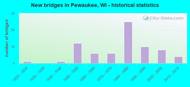
- New bridges - historical statistics
- 11920-1929
- 11940-1949
- 121950-1959
- 61960-1969
- 61970-1979
- 251980-1989
- 101990-1999
- 82000-2009
- 42010-2019
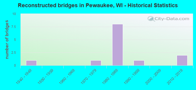
- Reconstructed bridges - Historical Statistics
- 11940-1949
- 01950-1959
- 01960-1969
- 11970-1979
- 81980-1989
- 11990-1999
- 02000-2009
- 22010-2019
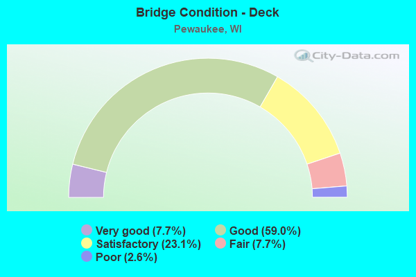
- Bridge Condition - Deck
- 7.7%Very good
- 59.0%Good
- 23.1%Satisfactory
- 7.7%Fair
- 2.6%Poor
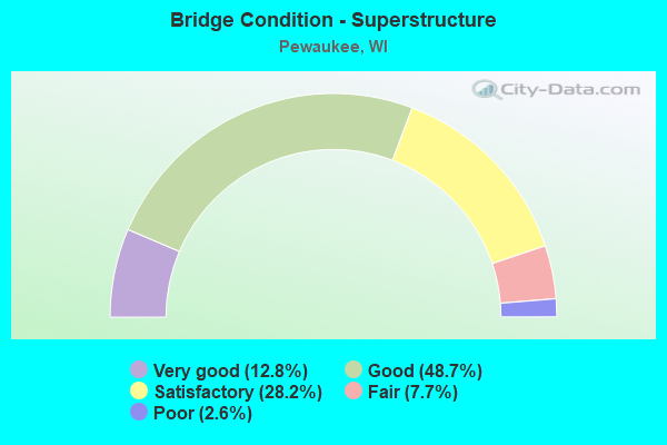
- Bridge Condition - Superstructure
- 12.8%Very good
- 48.7%Good
- 28.2%Satisfactory
- 7.7%Fair
- 2.6%Poor
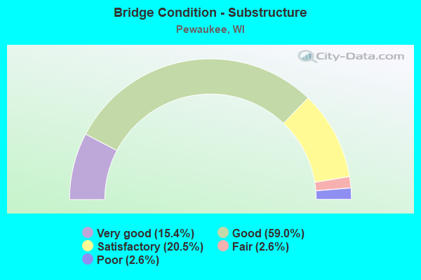
- Bridge Condition - Substructure
- 15.4%Very good
- 59.0%Good
- 20.5%Satisfactory
- 2.6%Fair
- 2.6%Poor
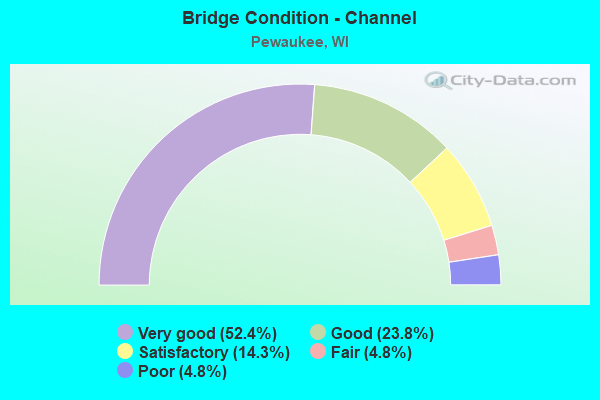
- Bridge Condition - Channel
- 52.4%Very good
- 23.8%Good
- 14.3%Satisfactory
- 4.8%Fair
- 4.8%Poor
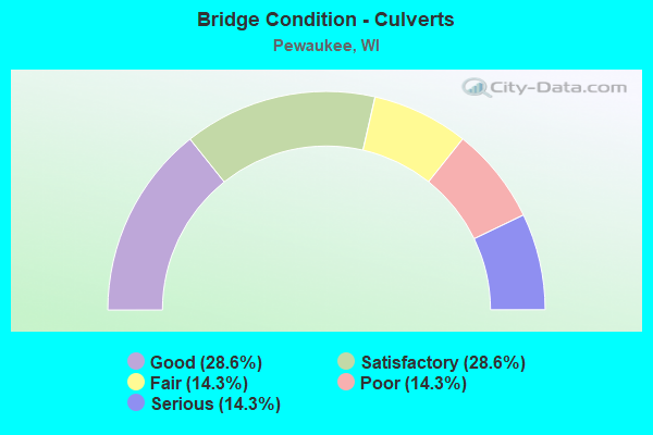
- Bridge Condition - Culverts
- 28.6%Good
- 28.6%Satisfactory
- 14.3%Fair
- 14.3%Poor
- 14.3%Serious
Find on map >> Show street view
Structure Number: B670282, Location: 1.8 MI N JCT STH 190 (Lat: 43.101814, Lng: -88.244544), Route carried "on" structure: State highway 164, Year Built: 2005, Status: Open, Structure Length: 1.31m (4.30ft), Average Daily Traffic: 9,325 (year 2018), Truck Traffic: 3%, Average Future Daily Traffic: 11,190 (year 2038), Design Load: HS 20, Features Intersected: PEWAUKEE RIVER
Minimum Vertical Clearance: 30+ m (98+ ft), Kilometerpoint: 0.000, Lanes on structure: 2, Base Highway Network: Yes, Owner: State Highway Agency, Approaching Roadway Width: 12.2m (40.0ft), Material/Design: Concrete, Design/Construction: Slab, Number Of Spans In Main Unit: 1, Length of Maximum Span: 12.3m (40.4ft), Curb-To-Curb Width: 12.2m (40.0ft), Out-to-Out Width: 13.0m (42.7ft)
Condition: Deck: Good, Superstructure: Good, Substructure: Good, Channel: Very good, Operating Rating: 63.7 metric tons, Method Used To Determine Operating Rating: Load Factor (LF), Inventory Rating: 38.9 metric tons, Method Used To Determine Inventory Rating: Load Factor (LF), Structural Evaluation: Better than present minimum criteria, Deck Geometry: Better than present minimum criteria, Waterway Adequacy: Equal to present desirable criteria, Approach Roadway Alignment: Equal to present desirable criteria, Designated Inspection Frequency: Every 48 months, Inspection Date: November 2021, Deck Structure Type: Concrete Cast-file-Place, Wearing Surface/Protective System: Wearing Surface: Monolithic Concrete
Find on map >> Show street view
Structure Number: B670306, Location: 0.5 M W STEPPING STONE WA (Lat: 43.102336, Lng: -88.252197), Route carried "on" structure: City street , Year Built: 2006, Status: Open, Structure Length: 0.66m (2.17ft), Average Daily Traffic: 630 (year 2019), Average Future Daily Traffic: 693 (year 2039), Design Load: HL 93, Features Intersected: DRAINAGE DITCH, Facility Carried by Structure: LRD POND VIEW CT R
Minimum Vertical Clearance: 30+ m (98+ ft), Kilometerpoint: 0.000, Lanes on structure: 2, Owner: City or Municipal Highway Agency, Approaching Roadway Width: 11.0m (36.1ft), Skew: 3 degrees, Material/Design: Concrete, Design/Construction: Culvert, Number Of Spans In Main Unit: 1, Length of Maximum Span: 6.3m (20.7ft)
Condition: Channel: Satisfactory, Culverts: Good, Operating Rating: 54.3 metric tons, Method Used To Determine Operating Rating: Field evaluation and documented engineering judgment, Inventory Rating: 36.0 metric tons, Method Used To Determine Inventory Rating: Field evaluation and documented engineering judgment, Structural Evaluation: Better than present minimum criteria, Waterway Adequacy: Equal to present desirable criteria, Approach Roadway Alignment: Equal to present desirable criteria, Designated Inspection Frequency: Every 24 months, Inspection Date: June 2020, Deck Structure Type: Concrete Cast-file-Place, Wearing Surface/Protective System: Wearing Surface: Bituminous
Find on map >> Show street view
Structure Number: B670331, Location: 7.7 M W JCT USH 45 (Lat: 43.083303, Lng: -88.205283), Route carried "on" structure: State highway 190, Year Built: 2017, Status: Open, Structure Length: 6.72m (22.05ft), Average Daily Traffic: 11,250 (year 2018), Average Future Daily Traffic: 16,500 (year 2039), Design Load: HL 93, Features Intersected: CTH F/ REDFORD BLVD
Minimum Vertical Clearance: 30+ m (98+ ft), Kilometerpoint: 0.000, Lanes on structure: 3, Lanes under structure: 4, Base Highway Network: Yes, Owner: State Highway Agency, Approaching Roadway Width: 20.7m (67.9ft), Material/Design: Prestressed concrete continuous, Design/Construction: Stringer/Multi-beam, Number Of Spans In Main Unit: 2, Length of Maximum Span: 32.9m (107.9ft), Curb-To-Curb Width: 20.7m (67.9ft), Out-to-Out Width: 21.5m (70.5ft)
Condition: Deck: Very good, Superstructure: Very good, Substructure: Very good, Operating Rating: 48.3 metric tons, Method Used To Determine Operating Rating: Load and Resistance Factor Rating (LRFR) rating reported by rating factor(RF) method using HL-93 loadings, Inventory Rating: 36.9 metric tons, Method Used To Determine Inventory Rating: Load and Resistance Factor Rating (LRFR) rating reported by rating factor(RF) method using HL-93 loadings, Structural Evaluation: Equal to present desirable criteria, Deck Geometry: Superior to present desirable criteria, Underclear: Somewhat better than minimum adequacy, Approach Roadway Alignment: Equal to present desirable criteria, Designated Inspection Frequency: Every 48 months, Inspection Date: August 2021, Deck Structure Type: Concrete Cast-file-Place, Wearing Surface/Protective System: Wearing Surface: Monolithic Concrete, Deck Protection: Epoxy Coated Reinforcing
Find on map >> Show street view
Structure Number: B670332, Location: 1.0 M E JCT STH 164 (Lat: 43.082928, Lng: -88.205931), Route carried "on" structure: State highway 190, Year Built: 2017, Status: Open, Structure Length: 6.72m (22.05ft), Average Daily Traffic: 11,250 (year 2018), Average Future Daily Traffic: 16,500 (year 2039), Design Load: HL 93, Features Intersected: CTH F/ REDFORD BLVD
Minimum Vertical Clearance: 30+ m (98+ ft), Kilometerpoint: 0.000, Lanes on structure: 3, Lanes under structure: 4, Base Highway Network: Yes, Owner: State Highway Agency, Approaching Roadway Width: 20.7m (67.9ft), Material/Design: Prestressed concrete continuous, Design/Construction: Stringer/Multi-beam, Number Of Spans In Main Unit: 2, Length of Maximum Span: 32.9m (107.9ft), Curb-To-Curb Width: 20.7m (67.9ft), Out-to-Out Width: 21.5m (70.5ft)
Condition: Deck: Very good, Superstructure: Very good, Substructure: Very good, Operating Rating: 48.3 metric tons, Method Used To Determine Operating Rating: Load and Resistance Factor Rating (LRFR) rating reported by rating factor(RF) method using HL-93 loadings, Inventory Rating: 36.9 metric tons, Method Used To Determine Inventory Rating: Load and Resistance Factor Rating (LRFR) rating reported by rating factor(RF) method using HL-93 loadings, Structural Evaluation: Equal to present desirable criteria, Deck Geometry: Superior to present desirable criteria, Underclear: Somewhat better than minimum adequacy, Approach Roadway Alignment: Equal to present desirable criteria, Designated Inspection Frequency: Every 45 months, Inspection Date: November 2021, Deck Structure Type: Concrete Cast-file-Place, Wearing Surface/Protective System: Wearing Surface: Monolithic Concrete, Deck Protection: Epoxy Coated Reinforcing
Find on map >> Show street view
Structure Number: P670094, Location: 0.6M N JCT CTH JJ (Lat: 43.047117, Lng: -88.216075), Route carried "on" structure: City street , Year Built: 1950, Status: Posted for load, Structure Length: 0.73m (2.40ft), Average Daily Traffic: 117 (year 2019), Average Future Daily Traffic: 128 (year 2040), Design Load: H 15, Features Intersected: PEWAUKEE RIVER, Facility Carried by Structure: LRD BUSSE RD
Minimum Vertical Clearance: 30+ m (98+ ft), Kilometerpoint: 0.000, Lanes on structure: 2, Owner: City or Municipal Highway Agency, Approaching Roadway Width: 7.3m (24.0ft), Material/Design: Steel, Design/Construction: Culvert, Number Of Spans In Main Unit: 2, Length of Maximum Span: 3.7m (12.1ft)
Condition: Channel: Fair, Culverts: Serious, Operating Rating: 16.0 metric tons, Method Used To Determine Operating Rating: Field evaluation and documented engineering judgment, Inventory Rating: 9.7 metric tons, Method Used To Determine Inventory Rating: Field evaluation and documented engineering judgment, Structural Evaluation: High priority of replacement, Waterway Adequacy: Meets minimum limits, Approach Roadway Alignment: Meets minimum limits, Bridge Posting: Required (Relationship of Operating Rating to Maximum Legal Load: 0.1 - 9.9% below), Length Of Structure Improvement: 1.19m (3.90ft), Designated Inspection Frequency: Every 12 months, Inspection Date: October 2021, Bridge Improvement Cost: $91,000, Roadway Improvement Cost: $9,000, Total Project Cost: $136,000 ( Estimate for 2021), Deck Structure Type: Corrugated Steel, Wearing Surface/Protective System: Wearing Surface: Bituminous
Find on map >> Show street view
Structure Number: P670922, Location: 0.7M W JCT CTH KF (Lat: 43.092892, Lng: -88.286061), Route carried "on" structure: County highway , Year Built: 1940, Status: Open, Structure Length: 0.77m (2.53ft), Average Daily Traffic: 3,200 (year 2019), Average Future Daily Traffic: 2,692 (year 2040), Design Load: H 15, Features Intersected: PEWAUKEE LAKE TRIB, Facility Carried by Structure: CTH JJ (CAPITOL DR
Minimum Vertical Clearance: 30+ m (98+ ft), Kilometerpoint: 0.000, Lanes on structure: 2, Owner: County Highway Agency, Approaching Roadway Width: 9.4m (30.8ft), Material/Design: Steel, Design/Construction: Culvert, Number Of Spans In Main Unit: 3, Length of Maximum Span: 2.1m (6.9ft)
Condition: Channel: Good, Culverts: Poor, Operating Rating: 33.0 metric tons, Method Used To Determine Operating Rating: Field evaluation and documented engineering judgment, Inventory Rating: 19.4 metric tons, Method Used To Determine Inventory Rating: Field evaluation and documented engineering judgment, Structural Evaluation: Meets minimum limits, Waterway Adequacy: High priority of corrective action, Approach Roadway Alignment: Equal to present desirable criteria, Length Of Structure Improvement: 1.22m (4.00ft), Designated Inspection Frequency: Every 12 months, Inspection Date: September 2021, Bridge Improvement Cost: $130,000, Roadway Improvement Cost: $13,000, Total Project Cost: $195,000 ( Estimate for 2021), Wearing Surface/Protective System: Wearing Surface: Bituminous
Find on map >> Show street view
Structure Number: B670014, Location: 8.6M E JCT STH 83 TO N (Lat: 43.048361, Lng: -88.207892), Route carried "under" structure: Interstate 94, Year Built: 1956, Structure Length: 0. m, Average Daily Traffic: 126,000 (year 2019), Truck Traffic: 1%, Features Intersected: IH 94, Facility Carried by Structure: CTH F SB
Minimum Vertical Clearance: 4.89m (16.04ft), Kilometerpoint: 0.000, Lanes on structure: 3, Lanes under structure: 6, Material/Design: Steel continuous, Design/Construction: Stringer/Multi-beam, Length of Maximum Span: 19.1m (62.7ft)
Find on map >> Show street view
Structure Number: B67004, Location: 0.4M N JCT CTH JJ (Lat: 43.042125, Lng: -88.185658), Route carried "under" structure: County highway , Year Built: 1958, Structure Length: 0. m, Average Daily Traffic: 11,900 (year 2018), Features Intersected: CTH SR (SPRINGDALE RD), Facility Carried by Structure: IH 94 WB
Minimum Vertical Clearance: 4.75m (15.58ft), Kilometerpoint: 0.000, Lanes on structure: 3, Lanes under structure: 2, Material/Design: Concrete continuous, Design/Construction: Slab, Length of Maximum Span: 13.4m (44.0ft)
Find on map >> Show street view
Structure Number: B670041, Location: 0.4M N JCT CTH JJ (Lat: 43.041886, Lng: -88.186067), Route carried "under" structure: City street , Year Built: 1958, Structure Length: 0. m, Average Daily Traffic: 11,900 (year 2018), Features Intersected: LRD CTH SR (SPRINGDALE R, Facility Carried by Structure: IH 94 EB
Minimum Vertical Clearance: 4.54m (14.90ft), Kilometerpoint: 0.000, Lanes on structure: 3, Lanes under structure: 2, Material/Design: Concrete continuous, Design/Construction: Slab, Length of Maximum Span: 13.4m (44.0ft)
Find on map >> Show street view
Structure Number: B670089, Location: 1.4M S JCT CTH V (Lat: 43.082925, Lng: -88.192583), Route carried "under" structure: City street , Year Built: 1966, Structure Length: 0. m, Average Daily Traffic: 2,300 (year 2019), Features Intersected: LRD DUPLAINEVILLE RD, Facility Carried by Structure: STH 190 WB
Minimum Vertical Clearance: 4.72m (15.49ft), Kilometerpoint: 0.000, Lanes on structure: 2, Lanes under structure: 2, Material/Design: Prestressed concrete continuous, Design/Construction: Stringer/Multi-beam, Length of Maximum Span: 21.3m (69.9ft)
Find on map >> Show street view
Structure Number: B670095, Location: 1.0M E JCT CTH F (Lat: 43.075550, Lng: -88.205536), Route carried "under" structure: City street , Year Built: 1966, Structure Length: 0. m, Average Daily Traffic: 1,900 (year 2018), Features Intersected: LRD GREEN RD, Facility Carried by Structure: CTH F NB (REDFORD
Minimum Vertical Clearance: 4.90m (16.08ft), Kilometerpoint: 0.000, Lanes on structure: 2, Lanes under structure: 2, Material/Design: Concrete continuous, Design/Construction: Slab, Length of Maximum Span: 15.7m (51.5ft)
Find on map >> Show street view
Structure Number: B67014, Location: 8.7M E JCT STH 83 TO N (Lat: 43.047644, Lng: -88.207622), Route carried "under" structure: Interstate 94, Year Built: 1977, Structure Length: 0. m, Average Daily Traffic: 126,000 (year 2019), Truck Traffic: 1%, Features Intersected: IH 94, Facility Carried by Structure: CTH F NB
Minimum Vertical Clearance: 4.83m (15.85ft), Kilometerpoint: 0.000, Lanes on structure: 3, Lanes under structure: 6, Material/Design: Steel continuous, Design/Construction: Stringer/Multi-beam, Length of Maximum Span: 19.1m (62.7ft)
Find on map >> Show street view
Structure Number: B670174, Location: 2.3M E JCT CTH KE TO S (Lat: 43.094597, Lng: -88.272689), Route carried "under" structure: State highway 16, Year Built: 1974, Structure Length: 0. m, Average Daily Traffic: 46,600 (year 2018), Truck Traffic: 7%, Features Intersected: STH 16, Facility Carried by Structure: CTH KF
Minimum Vertical Clearance: 5.00m (16.40ft), Kilometerpoint: 0.000, Lanes on structure: 3, Lanes under structure: 4, Material/Design: Steel continuous, Design/Construction: Stringer/Multi-beam, Length of Maximum Span: 40.8m (133.9ft)
Find on map >> Show street view
Structure Number: B670178, Location: AT JCT STH 16-STH 190 (Lat: 43.083339, Lng: -88.251094), Route carried "under" structure: State highway 190, Year Built: 1983, Structure Length: 0. m, Average Daily Traffic: 27,900 (year 2018), Truck Traffic: 3%, Features Intersected: STH 190 EB, Facility Carried by Structure: STH 16 WB
Minimum Vertical Clearance: 5.12m (16.80ft), Kilometerpoint: 0.000, Lanes on structure: 2, Lanes under structure: 5, Material/Design: Prestressed concrete continuous, Design/Construction: Stringer/Multi-beam, Length of Maximum Span: 25.1m (82.3ft)
Find on map >> Show street view
Structure Number: B670179, Location: AT JCT STH 16-STH 190 (Lat: 43.083747, Lng: -88.251528), Route carried "under" structure: State highway 190, Year Built: 1983, Structure Length: 0. m, Average Daily Traffic: 27,900 (year 2018), Truck Traffic: 3%, Features Intersected: STH 190 EB, Facility Carried by Structure: STH 16 EB
Minimum Vertical Clearance: 5.15m (16.90ft), Kilometerpoint: 0.000, Lanes on structure: 2, Lanes under structure: 4, Material/Design: Prestressed concrete continuous, Design/Construction: Stringer/Multi-beam, Length of Maximum Span: 25.1m (82.3ft)
Find on map >> Show street view
Structure Number: B67018, Location: 0.6M E JCT CAPITOL DR (Lat: 43.081106, Lng: -88.251103), Route carried "under" structure: City street , Year Built: 1983, Structure Length: 0. m, Average Daily Traffic: 100 (year 2019), Features Intersected: LRD HICKORY STREET, Facility Carried by Structure: STH 16 WB
Minimum Vertical Clearance: 7.11m (23.33ft), Kilometerpoint: 0.000, Lanes on structure: 2, Lanes under structure: 2, Material/Design: Steel continuous, Design/Construction: Stringer/Multi-beam, Length of Maximum Span: 26.2m (86.0ft)
Find on map >> Show street view
Structure Number: B670181, Location: 0.6M E JCT CAPITOL DR (Lat: 43.081844, Lng: -88.251556), Route carried "under" structure: City street , Year Built: 1983, Structure Length: 0. m, Average Daily Traffic: 100 (year 2019), Features Intersected: LRD HICKORY STREET, Facility Carried by Structure: STH 16 EB
Minimum Vertical Clearance: 7.32m (24.02ft), Kilometerpoint: 0.000, Lanes on structure: 2, Lanes under structure: 2, Material/Design: Steel continuous, Design/Construction: Stringer/Multi-beam, Length of Maximum Span: 26.2m (86.0ft)
Find on map >> Show street view
Structure Number: B670182, Location: AT JCT STH 16-STH 190 (Lat: 43.081039, Lng: -88.250864), Route carried "under" structure: City street , Year Built: 1983, Structure Length: 0. m, Average Daily Traffic: 100 (year 2019), Features Intersected: LRD HICKORY STREET, Facility Carried by Structure: STH RAMP STH 16 WB
Minimum Vertical Clearance: 7.19m (23.59ft), Kilometerpoint: 0.000, Lanes on structure: 1, Lanes under structure: 2, Material/Design: Steel continuous, Design/Construction: Stringer/Multi-beam, Length of Maximum Span: 25.1m (82.3ft)
Find on map >> Show street view
Structure Number: B670183, Location: AT JCT STH 16-STH 190 (Lat: 43.081944, Lng: -88.251981), Route carried "under" structure: City street , Year Built: 1983, Structure Length: 0. m, Average Daily Traffic: 100 (year 2019), Features Intersected: LRD HICKORY STREET, Facility Carried by Structure: STH RAMP, STH 190
Minimum Vertical Clearance: 8.22m (26.97ft), Kilometerpoint: 0.000, Lanes on structure: 1, Lanes under structure: 2, Material/Design: Steel continuous, Design/Construction: Stringer/Multi-beam, Length of Maximum Span: 32.8m (107.6ft)
Find on map >> Show street view
Structure Number: B670184, Location: AT JCT STH 16 (Lat: 43.078108, Lng: -88.251144), Route carried "under" structure: City street , Year Built: 1983, Structure Length: 0. m, Average Daily Traffic: 3,700 (year 2019), Features Intersected: LRD E.WISCONSIN AVE, Facility Carried by Structure: STH 16 WB
Minimum Vertical Clearance: 4.60m (15.09ft), Kilometerpoint: 0.000, Lanes on structure: 3, Lanes under structure: 2, Material/Design: Prestressed concrete, Design/Construction: Stringer/Multi-beam, Length of Maximum Span: 24.5m (80.4ft)
Find on map >> Show street view
Structure Number: B670185, Location: VILLAGE OF PEWAUKEE (Lat: 43.078753, Lng: -88.251650), Route carried "under" structure: City street , Year Built: 1983, Structure Length: 0. m, Average Daily Traffic: 3,700 (year 2019), Features Intersected: LRD E. WISCONSIN AVE, Facility Carried by Structure: STH 16 EB
Minimum Vertical Clearance: 4.75m (15.58ft), Kilometerpoint: 0.000, Lanes on structure: 3, Lanes under structure: 2, Material/Design: Prestressed concrete, Design/Construction: Stringer/Multi-beam, Length of Maximum Span: 24.5m (80.4ft)
Find on map >> Show street view
Structure Number: B670186, Location: 4.5M E JCT CTH KE (Lat: 43.071422, Lng: -88.251806), Route carried "under" structure: State highway 16, Year Built: 1983, Structure Length: 0. m, Average Daily Traffic: 43,800 (year 2019), Truck Traffic: 1%, Features Intersected: STH 16, Facility Carried by Structure: CTH JJ
Minimum Vertical Clearance: 5.27m (17.29ft), Kilometerpoint: 0.000, Lanes on structure: 4, Lanes under structure: 4, Material/Design: Steel continuous, Design/Construction: Stringer/Multi-beam, Length of Maximum Span: 31.2m (102.4ft)
Find on map >> Show street view
Structure Number: B670201, Location: TOWN OF PEWAUKEE (Lat: 43.082542, Lng: -88.192917), Route carried "under" structure: City street , Year Built: 1983, Structure Length: 0. m, Average Daily Traffic: 2,100 (year 2019), Features Intersected: LRD DUPLAINVILLE RD, Facility Carried by Structure: STH 190/CAPITOL DR
Minimum Vertical Clearance: 5.09m (16.70ft), Kilometerpoint: 0.000, Lanes on structure: 2, Lanes under structure: 2, Material/Design: Prestressed concrete continuous, Design/Construction: Stringer/Multi-beam, Length of Maximum Span: 22.9m (75.1ft)
Find on map >> Show street view
Structure Number: B670213, Location: 0.9M E JCT CTH F (Lat: 43.075553, Lng: -88.205539), Route carried "under" structure: City street , Year Built: 1987, Structure Length: 0. m, Average Daily Traffic: 1,200 (year 2019), Features Intersected: LRD GREEN RD, Facility Carried by Structure: CTH F SB (REDFORD
Minimum Vertical Clearance: 4.80m (15.75ft), Kilometerpoint: 0.000, Lanes on structure: 2, Lanes under structure: 2, Material/Design: Concrete continuous, Design/Construction: Slab, Length of Maximum Span: 15.7m (51.5ft)
Find on map >> Show street view
Structure Number: B670215, Location: AT CTH JJ (Lat: 43.038211, Lng: -88.211442), Route carried "under" structure: County highway , Year Built: 1989, Structure Length: 0. m, Average Daily Traffic: 24,750 (year 2018), Features Intersected: CTH F, Facility Carried by Structure: CTH JJ (BLUEMOUND
Minimum Vertical Clearance: 7.21m (23.65ft), Kilometerpoint: 0.000, Lanes on structure: 4, Lanes under structure: 4, Material/Design: Prestressed concrete continuous, Design/Construction: Stringer/Multi-beam, Length of Maximum Span: 39.3m (128.9ft)
Find on map >> Show street view
Structure Number: B670234, Location: 7.7M E JCT STH 83 TO N (Lat: 43.049431, Lng: -88.225814), Route carried "under" structure: Interstate 94, Year Built: 1993, Structure Length: 0. m, Average Daily Traffic: 128,000 (year 2019), Truck Traffic: 1%, Features Intersected: IH 94, Facility Carried by Structure: STH164 SB-CTH J SB
Minimum Vertical Clearance: 5.14m (16.86ft), Kilometerpoint: 0.000, Lanes on structure: 4, Lanes under structure: 6, Material/Design: Steel continuous, Design/Construction: Stringer/Multi-beam, Length of Maximum Span: 30.5m (100.1ft)
Find on map >> Show street view
Structure Number: B670235, Location: 7.7M E JCT STH 83 TO N (Lat: 43.048858, Lng: -88.225400), Route carried "under" structure: Interstate 94, Year Built: 1993, Structure Length: 0. m, Average Daily Traffic: 128,000 (year 2019), Truck Traffic: 1%, Features Intersected: IH 94, Facility Carried by Structure: CTH STH 164 NB - C
Minimum Vertical Clearance: 5.18m (16.99ft), Kilometerpoint: 0.000, Lanes on structure: 4, Lanes under structure: 6, Material/Design: Steel continuous, Design/Construction: Stringer/Multi-beam, Length of Maximum Span: 30.5m (100.1ft)
Find on map >> Show street view
Structure Number: B67024, Location: 7.1M E JCT STH 83 TO N (Lat: 43.048111, Lng: -88.236583), Route carried "under" structure: Interstate 94, Year Built: 1994, Structure Length: 0. m, Average Daily Traffic: 128,000 (year 2019), Truck Traffic: 1%, Features Intersected: IH 94, Facility Carried by Structure: CTH JJ
Minimum Vertical Clearance: 5.19m (17.03ft), Kilometerpoint: 0.000, Lanes on structure: 2, Lanes under structure: 8, Material/Design: Steel continuous, Design/Construction: Stringer/Multi-beam, Length of Maximum Span: 46.0m (150.9ft)
Find on map >> Show street view
Structure Number: B670244, Location: 6.7M E JCT STH 83 TO N (Lat: 43.047564, Lng: -88.249508), Route carried "under" structure: Interstate 94, Year Built: 1995, Structure Length: 0. m, Average Daily Traffic: 93,900 (year 2019), Truck Traffic: 1%, Features Intersected: IH 94, Facility Carried by Structure: STH 16 EB
Minimum Vertical Clearance: 5.21m (17.09ft), Kilometerpoint: 0.000, Lanes on structure: 2, Lanes under structure: 6, Material/Design: Steel continuous, Design/Construction: Stringer/Multi-beam, Length of Maximum Span: 50.3m (165.0ft)
Find on map >> Show street view
Structure Number: B670266, Location: 4.6M E JCT STH83 TO N (Lat: 43.048806, Lng: -88.285450), Route carried "under" structure: Interstate 94, Year Built: 2000, Structure Length: 0. m, Average Daily Traffic: 79,900 (year 2019), Truck Traffic: 12%, Features Intersected: IH 94, Facility Carried by Structure: STH 318
Minimum Vertical Clearance: 5.10m (16.73ft), Kilometerpoint: 0.000, Lanes on structure: 7, Lanes under structure: 6, Material/Design: Prestressed concrete, Design/Construction: Stringer/Multi-beam, Length of Maximum Span: 27.3m (89.6ft)
Find on map >> Show street view
Structure Number: B670267, Location: 3.8M E JCT STH 83 TO N (Lat: 43.050508, Lng: -88.303028), Route carried "under" structure: Interstate 94, Year Built: 2001, Structure Length: 0. m, Average Daily Traffic: 76,500 (year 2019), Features Intersected: IH 94, Facility Carried by Structure: CTH SS
Minimum Vertical Clearance: 5.24m (17.19ft), Kilometerpoint: 0.000, Lanes on structure: 6, Lanes under structure: 5, Material/Design: Prestressed concrete continuous, Design/Construction: Stringer/Multi-beam, Length of Maximum Span: 28.7m (94.2ft)
Find on map >> Show street view
Structure Number: B670331, Location: 0.2M E JCT STH 190 (Lat: 43.083303, Lng: -88.205283), Route carried "under" structure: County highway , Year Built: 2017, Structure Length: 0. m, Average Daily Traffic: 21,200 (year 2018), Features Intersected: CTH F/ REDFORD BLVD, Facility Carried by Structure: STH 190 WB
Minimum Vertical Clearance: 5.44m (17.85ft), Kilometerpoint: 0.000, Lanes on structure: 3, Lanes under structure: 4, Material/Design: Prestressed concrete continuous, Design/Construction: Stringer/Multi-beam, Length of Maximum Span: 32.9m (107.9ft)
Find on map >> Show street view
Structure Number: B670332, Location: 0.1M E JCT STH 190 (Lat: 43.082928, Lng: -88.205931), Route carried "under" structure: County highway , Year Built: 2017, Structure Length: 0. m, Average Daily Traffic: 21,200 (year 2018), Features Intersected: CTH F/ REDFORD BLVD, Facility Carried by Structure: STH 190 EB
Minimum Vertical Clearance: 5.54m (18.18ft), Kilometerpoint: 0.000, Lanes on structure: 3, Lanes under structure: 4, Material/Design: Prestressed concrete continuous, Design/Construction: Stringer/Multi-beam, Length of Maximum Span: 32.9m (107.9ft)