Bridge Statistics for Peridot, Arizona (AZ)
Condition, Traffic, Stress, Structural Evaluation, Project Costs
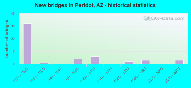
- New bridges - historical statistics
- 321920-1929
- 11930-1939
- 41950-1959
- 61960-1969
- 21980-1989
- 31990-1999
- 32010-2019


- Bridge Condition - Deck
- 3.7%Good
- 48.1%Satisfactory
- 33.3%Fair
- 14.8%Poor

- Bridge Condition - Superstructure
- 3.7%Very good
- 3.7%Good
- 40.7%Satisfactory
- 25.9%Fair
- 18.5%Poor
- 3.7%Critical
- 3.7%Imminent failure

- Bridge Condition - Substructure
- 7.4%Very good
- 70.4%Satisfactory
- 11.1%Fair
- 11.1%Poor

- Bridge Condition - Channel
- 6.1%Very good
- 20.4%Good
- 32.7%Satisfactory
- 32.7%Fair
- 8.2%Poor

- Bridge Condition - Culverts
- 4.3%Very good
- 47.8%Good
- 43.5%Satisfactory
- 4.3%Fair
Find on map >> Show street view
Structure Number: H164, Location: 4.2 KM S OF AZ 70/170 JCT (Lat: 33.261306, Lng: -110.463806), Route carried "on" structure: Federal lands road 3, Year Built: 1969, Status: Posted for load-capacity, Structure Length: 6.41m (21.03ft), Average Daily Traffic: 514 (year 2021), Truck Traffic: 4%, Average Future Daily Traffic: 720 (year 2039), Design Load: HS 20, Features Intersected: BOOT WASH
Minimum Vertical Clearance: 30+ m (98+ ft), Kilometerpoint: 30.123, Lanes on structure: 2, Owner: Bureau of Indian Affairs, Approaching Roadway Width: 8.2m (26.9ft), Material/Design: Concrete, Design/Construction: Stringer/Multi-beam, Number Of Spans In Main Unit: 6, Length of Maximum Span: 10.7m (35.1ft), Curb-To-Curb Width: 10.0m (32.8ft), Out-to-Out Width: 10.3m (33.8ft)
Condition: Deck: Satisfactory, Superstructure: Good, Substructure: Very good, Channel: Satisfactory, Operating Rating: 44.2 metric tons, Method Used To Determine Operating Rating: Allowable Stress (AS), Inventory Rating: 32.4 metric tons, Method Used To Determine Inventory Rating: Allowable Stress (AS), Structural Evaluation: Better than present minimum criteria, Deck Geometry: Equal to present minimum criteria, Waterway Adequacy: Better than present minimum criteria, Approach Roadway Alignment: Equal to present desirable criteria, Designated Inspection Frequency: Every 24 months, Inspection Date: December 2021, Deck Structure Type: Concrete Cast-file-Place, Wearing Surface/Protective System: Wearing Surface: Monolithic Concrete
Find on map >> Show street view
Structure Number: H167, Location: 16 KM SOUTH OF HWY 70 (Lat: 33.196667, Lng: -110.525917), Route carried "on" structure: Federal lands road 3, Year Built: 1930, Status: Posted for load-capacity, Structure Length: 4.74m (15.55ft), Average Daily Traffic: 514 (year 2021), Truck Traffic: 4%, Average Future Daily Traffic: 743 (year 2038), Features Intersected: SODA SPRINGS GULCH
Minimum Vertical Clearance: 30+ m (98+ ft), Kilometerpoint: 40.300, Lanes on structure: 2, Owner: Bureau of Indian Affairs, Approaching Roadway Width: 7.0m (23.0ft), Material/Design: Concrete, Design/Construction: Tee Beam, Number Of Spans In Main Unit: 5, Length of Maximum Span: 9.5m (31.2ft), Curb or Sidewalk Widths: Left: 0.4m (1.3ft), Right: 0.4m (1.3ft), Curb-To-Curb Width: 7.4m (24.3ft), Out-to-Out Width: 8.3m (27.2ft)
Condition: Deck: Fair, Superstructure: Satisfactory, Substructure: Satisfactory, Channel: Poor, Operating Rating: 44.5 metric tons, Method Used To Determine Operating Rating: No rating analysis performed, Inventory Rating: 32.6 metric tons, Method Used To Determine Inventory Rating: No rating analysis performed, Structural Evaluation: Equal to present minimum criteria, Deck Geometry: Meets minimum limits, Waterway Adequacy: Meets minimum limits, Approach Roadway Alignment: Meets minimum limits, Designated Inspection Frequency: Every 24 months, Inspection Date: December 2021, Deck Structure Type: Concrete Cast-file-Place, Wearing Surface/Protective System: Wearing Surface: Monolithic Concrete
Find on map >> Show street view
Structure Number: H168, Location: 2.4 KM E OF DAM SPILLWAY (Lat: 33.171250, Lng: -110.503583), Route carried "on" structure: Federal lands road 3, Year Built: 1929, Status: Posted for load-capacity, Structure Length: 0.63m (2.07ft), Average Daily Traffic: 390 (year 2021), Truck Traffic: 2%, Average Future Daily Traffic: 456 (year 2039), Design Load: H 15, Features Intersected: GULCH
Minimum Vertical Clearance: 30+ m (98+ ft), Kilometerpoint: 47.240, Lanes on structure: 2, Owner: Bureau of Indian Affairs, Approaching Roadway Width: 6.0m (19.7ft), Material/Design: Concrete, Design/Construction: Culvert, Number Of Spans In Main Unit: 2, Length of Maximum Span: 3.1m (10.2ft), Curb or Sidewalk Widths: Left: 0.3m (1.0ft), Right: 0.3m (1.0ft), Curb-To-Curb Width: 6.0m (19.7ft), Out-to-Out Width: 8.7m (28.5ft)
Condition: Channel: Poor, Culverts: Good, Operating Rating: 33.1 metric tons, Method Used To Determine Operating Rating: Allowable Stress (AS), Inventory Rating: 24.3 metric tons, Method Used To Determine Inventory Rating: Allowable Stress (AS), Structural Evaluation: Equal to present minimum criteria, Deck Geometry: High priority of corrective action, Waterway Adequacy: Equal to present minimum criteria, Approach Roadway Alignment: Equal to present desirable criteria, Designated Inspection Frequency: Every 24 months, Inspection Date: December 2021
Find on map >> Show street view
Structure Number: H169, Location: 3.4 KM E OF COOLIDGE DAM (Lat: 33.167778, Lng: -110.495056), Route carried "on" structure: Federal lands road 3, Year Built: 1929, Status: Posted for load-capacity, Structure Length: 0.90m (2.95ft), Average Daily Traffic: 390 (year 2021), Truck Traffic: 2%, Average Future Daily Traffic: 507 (year 2039), Design Load: HS 20+Mod, Features Intersected: WASH
Minimum Vertical Clearance: 30+ m (98+ ft), Kilometerpoint: 48.305, Lanes on structure: 2, Owner: Bureau of Indian Affairs, Approaching Roadway Width: 6.0m (19.7ft), Material/Design: Concrete, Design/Construction: Culvert, Number Of Spans In Main Unit: 1, Length of Maximum Span: 9.0m (29.5ft), Curb-To-Curb Width: 6.0m (19.7ft), Out-to-Out Width: 22.2m (72.8ft)
Condition: Channel: Good, Culverts: Good, Operating Rating: 36.2 metric tons, Method Used To Determine Operating Rating: Load Factor (LF), Inventory Rating: 32.6 metric tons, Method Used To Determine Inventory Rating: Load Factor (LF), Structural Evaluation: Better than present minimum criteria, Deck Geometry: High priority of corrective action, Waterway Adequacy: Equal to present desirable criteria, Approach Roadway Alignment: Equal to present desirable criteria, Designated Inspection Frequency: Every 24 months, Inspection Date: December 2021
Find on map >> Show street view
Structure Number: H17, Location: 4.3 KM E OF COOLIDGE DAM (Lat: 33.163250, Lng: -110.487111), Route carried "on" structure: Federal lands road 3, Year Built: 1929, Status: Posted for load-capacity, Structure Length: 2.45m (8.04ft), Average Daily Traffic: 390 (year 2021), Truck Traffic: 2%, Average Future Daily Traffic: 510 (year 2039), Design Load: H 15, Features Intersected: ROCKHOUSE CANYON
Minimum Vertical Clearance: 30+ m (98+ ft), Kilometerpoint: 49.060, Lanes on structure: 2, Owner: Bureau of Indian Affairs, Approaching Roadway Width: 6.3m (20.7ft), Skew: 4 degrees, Material/Design: Concrete, Design/Construction: Tee Beam, Number Of Spans In Main Unit: 2, Length of Maximum Span: 12.0m (39.4ft), Curb or Sidewalk Widths: Left: 0.4m (1.3ft), Right: 0.4m (1.3ft), Curb-To-Curb Width: 6.1m (20.0ft), Out-to-Out Width: 7.0m (23.0ft)
Condition: Deck: Satisfactory, Superstructure: Satisfactory, Substructure: Satisfactory, Channel: Fair, Operating Rating: 25.7 metric tons, Method Used To Determine Operating Rating: Allowable Stress (AS), Inventory Rating: 18.9 metric tons, Method Used To Determine Inventory Rating: Allowable Stress (AS), Structural Evaluation: Somewhat better than minimum adequacy, Deck Geometry: Meets minimum limits, Waterway Adequacy: Better than present minimum criteria, Approach Roadway Alignment: Equal to present desirable criteria, Bridge Posting: Required (Relationship of Operating Rating to Maximum Legal Load: 20.0 - 29.9% below), Designated Inspection Frequency: Every 24 months, Inspection Date: December 2021, Deck Structure Type: Concrete Cast-file-Place, Wearing Surface/Protective System: Wearing Surface: Bituminous
Find on map >> Show street view
Structure Number: H171, Location: 9.8 KM E OF COOLIDGE DAM (Lat: 33.163139, Lng: -110.439361), Route carried "on" structure: Federal lands road 3, Year Built: 1929, Status: Posted for load-capacity, Structure Length: 3.04m (9.97ft), Average Daily Traffic: 390 (year 2021), Truck Traffic: 2%, Average Future Daily Traffic: 507 (year 2039), Design Load: H 15, Features Intersected: SQUAW CANYON
Minimum Vertical Clearance: 30+ m (98+ ft), Kilometerpoint: 54.640, Lanes on structure: 2, Owner: Bureau of Indian Affairs, Approaching Roadway Width: 6.5m (21.3ft), Material/Design: Concrete, Design/Construction: Slab, Number Of Spans In Main Unit: 5, Length of Maximum Span: 6.1m (20.0ft), Curb or Sidewalk Widths: Left: 0.4m (1.3ft), Right: 0.4m (1.3ft), Curb-To-Curb Width: 6.7m (22.0ft), Out-to-Out Width: 7.6m (24.9ft)
Condition: Deck: Fair, Superstructure: Fair, Substructure: Satisfactory, Channel: Satisfactory, Operating Rating: 33.1 metric tons, Method Used To Determine Operating Rating: Allowable Stress (AS), Inventory Rating: 24.3 metric tons, Method Used To Determine Inventory Rating: Allowable Stress (AS), Structural Evaluation: Somewhat better than minimum adequacy, Deck Geometry: Meets minimum limits, Waterway Adequacy: Better than present minimum criteria, Approach Roadway Alignment: Equal to present minimum criteria, Bridge Posting: Required (Relationship of Operating Rating to Maximum Legal Load: 10.0 - 19.9% below), Designated Inspection Frequency: Every 24 months, Inspection Date: December 2021, Deck Structure Type: Concrete Cast-file-Place, Wearing Surface/Protective System: Wearing Surface: Bituminous
Find on map >> Show street view
Structure Number: H172, Location: 11 KM E OF COOLIDGE DAM (Lat: 33.157417, Lng: -110.431500), Route carried "on" structure: Federal lands road 3, Year Built: 1929, Status: Posted for load-capacity, Structure Length: 2.01m (6.59ft), Average Daily Traffic: 390 (year 2021), Truck Traffic: 2%, Average Future Daily Traffic: 507 (year 2039), Design Load: H 15, Features Intersected: COTTONWOOD CANYON
Minimum Vertical Clearance: 30+ m (98+ ft), Kilometerpoint: 55.720, Lanes on structure: 2, Owner: Bureau of Indian Affairs, Approaching Roadway Width: 5.7m (18.7ft), Material/Design: Concrete, Design/Construction: Slab, Number Of Spans In Main Unit: 3, Length of Maximum Span: 6.7m (22.0ft), Curb or Sidewalk Widths: Left: 0.4m (1.3ft), Right: 0.4m (1.3ft), Curb-To-Curb Width: 6.7m (22.0ft), Out-to-Out Width: 7.6m (24.9ft)
Condition: Deck: Satisfactory, Superstructure: Satisfactory, Substructure: Satisfactory, Channel: Satisfactory, Operating Rating: 33.1 metric tons, Method Used To Determine Operating Rating: Allowable Stress (AS), Inventory Rating: 24.3 metric tons, Method Used To Determine Inventory Rating: Allowable Stress (AS), Structural Evaluation: Equal to present minimum criteria, Deck Geometry: Meets minimum limits, Waterway Adequacy: Equal to present minimum criteria, Approach Roadway Alignment: Equal to present desirable criteria, Bridge Posting: Required (Relationship of Operating Rating to Maximum Legal Load: 20.0 - 29.9% below), Designated Inspection Frequency: Every 24 months, Inspection Date: December 2021, Deck Structure Type: Concrete Cast-file-Place, Wearing Surface/Protective System: Wearing Surface: Bituminous
Find on map >> Show street view
Structure Number: H173, Location: 15 KM E OF COOLIDGE DAM (Lat: 33.159383, Lng: -110.408383), Route carried "on" structure: Federal lands road 3, Year Built: 1929, Status: Posted for load-capacity, Structure Length: 2.68m (8.79ft), Average Daily Traffic: 390 (year 2021), Truck Traffic: 2%, Average Future Daily Traffic: 507 (year 2039), Design Load: H 15, Features Intersected: KELLY GULCH
Minimum Vertical Clearance: 30+ m (98+ ft), Kilometerpoint: 59.720, Lanes on structure: 2, Owner: Bureau of Indian Affairs, Approaching Roadway Width: 5.5m (18.0ft), Material/Design: Concrete, Design/Construction: Slab, Number Of Spans In Main Unit: 4, Length of Maximum Span: 6.7m (22.0ft), Curb or Sidewalk Widths: Left: 0.4m (1.3ft), Right: 0.4m (1.3ft), Curb-To-Curb Width: 6.7m (22.0ft), Out-to-Out Width: 7.6m (24.9ft)
Condition: Deck: Poor, Superstructure: Poor, Substructure: Satisfactory, Channel: Fair, Operating Rating: 33.1 metric tons, Method Used To Determine Operating Rating: Allowable Stress (AS), Inventory Rating: 24.3 metric tons, Method Used To Determine Inventory Rating: Allowable Stress (AS), Structural Evaluation: Meets minimum limits, Deck Geometry: Meets minimum limits, Waterway Adequacy: Better than present minimum criteria, Approach Roadway Alignment: Somewhat better than minimum adequacy, Bridge Posting: Required (Relationship of Operating Rating to Maximum Legal Load: 10.0 - 19.9% below), Length Of Structure Improvement: 3.00m (9.84ft), Designated Inspection Frequency: Every 24 months, Inspection Date: December 2021, Bridge Improvement Cost: $990,000, Roadway Improvement Cost: $100,000, Total Project Cost: $1,290,000 ( Estimate for 2021), Deck Structure Type: Concrete Cast-file-Place, Wearing Surface/Protective System: Wearing Surface: Monolithic Concrete
Find on map >> Show street view
Structure Number: H175, Location: 17.9 KM E OF COOLIDGE DAM (Lat: 33.169417, Lng: -110.380444), Route carried "on" structure: Federal lands road 3, Year Built: 1929, Status: Posted for load-capacity, Structure Length: 1.65m (5.41ft), Average Daily Traffic: 350 (year 2021), Truck Traffic: 2%, Average Future Daily Traffic: 455 (year 2039), Design Load: H 15, Features Intersected: MAVERICK DRAW
Minimum Vertical Clearance: 30+ m (98+ ft), Kilometerpoint: 62.670, Lanes on structure: 2, Owner: Bureau of Indian Affairs, Approaching Roadway Width: 5.3m (17.4ft), Material/Design: Concrete, Design/Construction: Slab, Number Of Spans In Main Unit: 3, Length of Maximum Span: 5.5m (18.0ft), Curb or Sidewalk Widths: Left: 0.4m (1.3ft), Right: 0.4m (1.3ft), Curb-To-Curb Width: 6.1m (20.0ft), Out-to-Out Width: 7.0m (23.0ft)
Condition: Deck: Fair, Superstructure: Fair, Substructure: Satisfactory, Channel: Poor, Operating Rating: 33.1 metric tons, Method Used To Determine Operating Rating: Allowable Stress (AS), Inventory Rating: 24.3 metric tons, Method Used To Determine Inventory Rating: Allowable Stress (AS), Structural Evaluation: Somewhat better than minimum adequacy, Deck Geometry: Meets minimum limits, Waterway Adequacy: Equal to present minimum criteria, Approach Roadway Alignment: Equal to present desirable criteria, Bridge Posting: Required (Relationship of Operating Rating to Maximum Legal Load: 10.0 - 19.9% below), Designated Inspection Frequency: Every 24 months, Inspection Date: December 2021, Deck Structure Type: Concrete Cast-file-Place, Wearing Surface/Protective System: Wearing Surface: Monolithic Concrete
Find on map >> Show street view
Structure Number: H176, Location: 11.6 MI E DAM SPILLWAY (Lat: 33.172167, Lng: -110.373361), Route carried "on" structure: Federal lands road 3, Year Built: 1929, Status: Posted for load-capacity, Structure Length: 0.64m (2.10ft), Average Daily Traffic: 350 (year 2021), Truck Traffic: 2%, Average Future Daily Traffic: 410 (year 2039), Design Load: H 15, Features Intersected: GULCH
Minimum Vertical Clearance: 30+ m (98+ ft), Kilometerpoint: 63.430, Lanes on structure: 2, Owner: Bureau of Indian Affairs, Approaching Roadway Width: 7.3m (24.0ft), Material/Design: Concrete, Design/Construction: Culvert, Number Of Spans In Main Unit: 2, Length of Maximum Span: 3.1m (10.2ft), Curb or Sidewalk Widths: Left: 0.3m (1.0ft), Right: 0.3m (1.0ft), Curb-To-Curb Width: 7.3m (24.0ft), Out-to-Out Width: 7.8m (25.6ft)
Condition: Channel: Fair, Culverts: Satisfactory, Operating Rating: 32.5 metric tons, Method Used To Determine Operating Rating: Allowable Stress (AS), Inventory Rating: 24.3 metric tons, Method Used To Determine Inventory Rating: Allowable Stress (AS), Structural Evaluation: Equal to present minimum criteria, Deck Geometry: Somewhat better than minimum adequacy, Waterway Adequacy: Better than present minimum criteria, Approach Roadway Alignment: Equal to present desirable criteria, Designated Inspection Frequency: Every 24 months, Inspection Date: December 2021, Deck Structure Type: Concrete Cast-file-Place, Wearing Surface/Protective System: Wearing Surface: Bituminous
Find on map >> Show street view
Structure Number: H177, Location: 19.8 KM E OF DAM SPILLWAY (Lat: 33.178278, Lng: -110.363417), Route carried "on" structure: Federal lands road 3, Year Built: 1929, Status: Posted for load-capacity, Structure Length: 0.64m (2.10ft), Average Daily Traffic: 350 (year 2021), Truck Traffic: 2%, Average Future Daily Traffic: 410 (year 2039), Design Load: H 15, Features Intersected: GULCH
Minimum Vertical Clearance: 30+ m (98+ ft), Kilometerpoint: 64.580, Lanes on structure: 2, Owner: Bureau of Indian Affairs, Approaching Roadway Width: 7.3m (24.0ft), Material/Design: Concrete, Design/Construction: Culvert, Number Of Spans In Main Unit: 2, Length of Maximum Span: 3.1m (10.2ft), Curb or Sidewalk Widths: Left: 0.3m (1.0ft), Right: 0.3m (1.0ft), Curb-To-Curb Width: 7.3m (24.0ft), Out-to-Out Width: 7.8m (25.6ft)
Condition: Channel: Fair, Culverts: Satisfactory, Operating Rating: 32.5 metric tons, Method Used To Determine Operating Rating: Allowable Stress (AS), Inventory Rating: 24.3 metric tons, Method Used To Determine Inventory Rating: Allowable Stress (AS), Structural Evaluation: Equal to present minimum criteria, Deck Geometry: Somewhat better than minimum adequacy, Waterway Adequacy: Better than present minimum criteria, Approach Roadway Alignment: Equal to present desirable criteria, Designated Inspection Frequency: Every 24 months, Inspection Date: December 2021, Deck Structure Type: Concrete Cast-file-Place, Wearing Surface/Protective System: Wearing Surface: Bituminous
Find on map >> Show street view
Structure Number: H178, Location: 20 KM E OF COOLIDGE DAM (Lat: 33.179306, Lng: -110.361889), Route carried "on" structure: Federal lands road 3, Year Built: 1929, Status: Posted for load-capacity, Structure Length: 1.34m (4.40ft), Average Daily Traffic: 350 (year 2021), Truck Traffic: 2%, Average Future Daily Traffic: 410 (year 2039), Design Load: H 15, Features Intersected: MAVERICK GULCH
Minimum Vertical Clearance: 30+ m (98+ ft), Kilometerpoint: 64.770, Lanes on structure: 2, Owner: Bureau of Indian Affairs, Approaching Roadway Width: 6.0m (19.7ft), Material/Design: Concrete, Design/Construction: Slab, Number Of Spans In Main Unit: 2, Length of Maximum Span: 6.5m (21.3ft), Curb or Sidewalk Widths: Left: 0.4m (1.3ft), Right: 0.4m (1.3ft), Curb-To-Curb Width: 6.1m (20.0ft), Out-to-Out Width: 7.0m (23.0ft)
Condition: Deck: Satisfactory, Superstructure: Satisfactory, Substructure: Satisfactory, Channel: Fair, Operating Rating: 33.1 metric tons, Method Used To Determine Operating Rating: Allowable Stress (AS), Inventory Rating: 24.3 metric tons, Method Used To Determine Inventory Rating: Allowable Stress (AS), Structural Evaluation: Equal to present minimum criteria, Deck Geometry: Meets minimum limits, Waterway Adequacy: Better than present minimum criteria, Approach Roadway Alignment: Equal to present desirable criteria, Bridge Posting: Required (Relationship of Operating Rating to Maximum Legal Load: 10.0 - 19.9% below), Designated Inspection Frequency: Every 24 months, Inspection Date: December 2021, Deck Structure Type: Concrete Cast-file-Place, Wearing Surface/Protective System: Wearing Surface: Bituminous
Find on map >> Show street view
Structure Number: H179, Location: 20.6 KM E OF COOLIDGE DAM (Lat: 33.182722, Lng: -110.356028), Route carried "on" structure: Federal lands road 3, Year Built: 1929, Status: Posted for load-capacity, Structure Length: 2.44m (8.01ft), Average Daily Traffic: 350 (year 2021), Truck Traffic: 2%, Average Future Daily Traffic: 410 (year 2039), Design Load: H 15, Features Intersected: ROAD HOUSE CANYON
Minimum Vertical Clearance: 30+ m (98+ ft), Kilometerpoint: 65.410, Lanes on structure: 2, Owner: Bureau of Indian Affairs, Approaching Roadway Width: 5.3m (17.4ft), Material/Design: Concrete, Design/Construction: Slab, Number Of Spans In Main Unit: 4, Length of Maximum Span: 6.1m (20.0ft), Curb or Sidewalk Widths: Left: 0.4m (1.3ft), Right: 0.4m (1.3ft), Curb-To-Curb Width: 6.1m (20.0ft), Out-to-Out Width: 7.0m (23.0ft)
Condition: Deck: Satisfactory, Superstructure: Satisfactory, Substructure: Fair, Channel: Poor, Operating Rating: 33.1 metric tons, Method Used To Determine Operating Rating: Allowable Stress (AS), Inventory Rating: 24.3 metric tons, Method Used To Determine Inventory Rating: Allowable Stress (AS), Structural Evaluation: Somewhat better than minimum adequacy, Deck Geometry: Meets minimum limits, Waterway Adequacy: Equal to present minimum criteria, Approach Roadway Alignment: Equal to present desirable criteria, Bridge Posting: Required (Relationship of Operating Rating to Maximum Legal Load: 10.0 - 19.9% below), Designated Inspection Frequency: Every 24 months, Inspection Date: December 2021, Deck Structure Type: Concrete Cast-file-Place, Wearing Surface/Protective System: Wearing Surface: Bituminous
Find on map >> Show street view
Structure Number: H18, Location: 22.9 KM E OF COOLIDGE DAM (Lat: 33.188833, Lng: -110.333111), Route carried "on" structure: Federal lands road 3, Year Built: 1929, Status: Posted for load-capacity, Structure Length: 1.83m (6.00ft), Average Daily Traffic: 350 (year 2021), Truck Traffic: 2%, Average Future Daily Traffic: 410 (year 2039), Design Load: H 15, Features Intersected: SHERMAN DRAW
Minimum Vertical Clearance: 30+ m (98+ ft), Kilometerpoint: 67.700, Lanes on structure: 2, Owner: Bureau of Indian Affairs, Approaching Roadway Width: 5.4m (17.7ft), Skew: 3 degrees, Material/Design: Concrete, Design/Construction: Slab, Number Of Spans In Main Unit: 3, Length of Maximum Span: 6.1m (20.0ft), Curb or Sidewalk Widths: Left: 0.4m (1.3ft), Right: 0.4m (1.3ft), Curb-To-Curb Width: 6.1m (20.0ft), Out-to-Out Width: 7.0m (23.0ft)
Condition: Deck: Fair, Superstructure: Fair, Substructure: Fair, Channel: Fair, Operating Rating: 33.1 metric tons, Method Used To Determine Operating Rating: Allowable Stress (AS), Inventory Rating: 24.3 metric tons, Method Used To Determine Inventory Rating: Allowable Stress (AS), Structural Evaluation: Somewhat better than minimum adequacy, Deck Geometry: Meets minimum limits, Waterway Adequacy: Better than present minimum criteria, Approach Roadway Alignment: Equal to present desirable criteria, Bridge Posting: Required (Relationship of Operating Rating to Maximum Legal Load: 10.0 - 19.9% below), Designated Inspection Frequency: Every 24 months, Inspection Date: December 2021, Deck Structure Type: Concrete Cast-file-Place, Wearing Surface/Protective System: Wearing Surface: Bituminous
Find on map >> Show street view
Structure Number: H181, Location: 23.2 KM E OF DAM SPILLWAY (Lat: 33.189917, Lng: -110.331222), Route carried "on" structure: Federal lands road 3, Year Built: 1929, Status: Posted for load-capacity, Structure Length: 2.44m (8.01ft), Average Daily Traffic: 350 (year 2021), Truck Traffic: 2%, Average Future Daily Traffic: 410 (year 2039), Design Load: H 15, Features Intersected: SYCAMORE GULCH
Minimum Vertical Clearance: 30+ m (98+ ft), Kilometerpoint: 67.900, Lanes on structure: 2, Owner: Bureau of Indian Affairs, Approaching Roadway Width: 5.5m (18.0ft), Material/Design: Concrete, Design/Construction: Slab, Number Of Spans In Main Unit: 4, Length of Maximum Span: 6.1m (20.0ft), Curb or Sidewalk Widths: Left: 0.4m (1.3ft), Right: 0.4m (1.3ft), Curb-To-Curb Width: 6.7m (22.0ft), Out-to-Out Width: 7.6m (24.9ft)
Condition: Deck: Satisfactory, Superstructure: Satisfactory, Substructure: Fair, Channel: Satisfactory, Operating Rating: 33.1 metric tons, Method Used To Determine Operating Rating: Allowable Stress (AS), Inventory Rating: 24.4 metric tons, Method Used To Determine Inventory Rating: Allowable Stress (AS), Structural Evaluation: Somewhat better than minimum adequacy, Deck Geometry: Meets minimum limits, Waterway Adequacy: Better than present minimum criteria, Approach Roadway Alignment: Equal to present minimum criteria, Bridge Posting: Required (Relationship of Operating Rating to Maximum Legal Load: 10.0 - 19.9% below), Designated Inspection Frequency: Every 24 months, Inspection Date: December 2021, Deck Structure Type: Concrete Cast-file-Place, Wearing Surface/Protective System: Wearing Surface: Bituminous
Find on map >> Show street view
Structure Number: H182, Location: 24.1 KM OF COOLIDGE DAM (Lat: 33.195472, Lng: -110.324278), Route carried "on" structure: Federal lands road 3, Year Built: 1929, Status: Posted for load-capacity, Structure Length: 0.64m (2.10ft), Average Daily Traffic: 350 (year 2021), Truck Traffic: 2%, Average Future Daily Traffic: 410 (year 2039), Design Load: H 15, Features Intersected: GULCH
Minimum Vertical Clearance: 30+ m (98+ ft), Kilometerpoint: 68.880, Lanes on structure: 2, Owner: Bureau of Indian Affairs, Approaching Roadway Width: 7.3m (24.0ft), Material/Design: Concrete, Design/Construction: Culvert, Number Of Spans In Main Unit: 2, Length of Maximum Span: 3.0m (9.8ft), Curb or Sidewalk Widths: Left: 0.3m (1.0ft), Right: 0.3m (1.0ft), Curb-To-Curb Width: 7.3m (24.0ft), Out-to-Out Width: 7.8m (25.6ft)
Condition: Channel: Fair, Culverts: Fair, Operating Rating: 32.5 metric tons, Method Used To Determine Operating Rating: Allowable Stress (AS), Inventory Rating: 24.3 metric tons, Method Used To Determine Inventory Rating: Allowable Stress (AS), Structural Evaluation: Somewhat better than minimum adequacy, Deck Geometry: Somewhat better than minimum adequacy, Waterway Adequacy: Better than present minimum criteria, Approach Roadway Alignment: Equal to present desirable criteria, Designated Inspection Frequency: Every 24 months, Inspection Date: December 2021, Deck Structure Type: Concrete Cast-file-Place, Wearing Surface/Protective System: Wearing Surface: Bituminous
Find on map >> Show street view
Structure Number: H183, Location: 25.1 KM E OF COOLIDGE DAM (Lat: 33.196639, Lng: -110.313333), Route carried "on" structure: Federal lands road 3, Year Built: 1929, Status: Posted for load-capacity, Structure Length: 1.24m (4.07ft), Average Daily Traffic: 210 (year 2021), Truck Traffic: 2%, Average Future Daily Traffic: 250 (year 2039), Design Load: H 15, Features Intersected: J K GULCH
Minimum Vertical Clearance: 30+ m (98+ ft), Kilometerpoint: 69.950, Lanes on structure: 2, Owner: Bureau of Indian Affairs, Approaching Roadway Width: 5.5m (18.0ft), Material/Design: Concrete, Design/Construction: Tee Beam, Number Of Spans In Main Unit: 1, Length of Maximum Span: 12.1m (39.7ft), Curb or Sidewalk Widths: Left: 0.4m (1.3ft), Right: 0.4m (1.3ft), Curb-To-Curb Width: 6.1m (20.0ft), Out-to-Out Width: 7.0m (23.0ft)
Condition: Deck: Fair, Superstructure: Satisfactory, Substructure: Satisfactory, Channel: Good, Operating Rating: 25.7 metric tons, Method Used To Determine Operating Rating: Allowable Stress (AS), Inventory Rating: 21.0 metric tons, Method Used To Determine Inventory Rating: Allowable Stress (AS), Structural Evaluation: Equal to present minimum criteria, Deck Geometry: Meets minimum limits, Waterway Adequacy: Better than present minimum criteria, Approach Roadway Alignment: Equal to present desirable criteria, Bridge Posting: Required (Relationship of Operating Rating to Maximum Legal Load: 20.0 - 29.9% below), Designated Inspection Frequency: Every 24 months, Inspection Date: December 2021, Deck Structure Type: Concrete Cast-file-Place, Wearing Surface/Protective System: Wearing Surface: Bituminous
Find on map >> Show street view
Structure Number: H184, Location: 25.7 KM E OF COOLIDGE DAM (Lat: 33.195194, Lng: -110.307222), Route carried "on" structure: Federal lands road 3, Year Built: 1929, Status: Posted for load-capacity, Structure Length: 1.21m (3.97ft), Average Daily Traffic: 210 (year 2021), Truck Traffic: 2%, Average Future Daily Traffic: 250 (year 2039), Design Load: H 15, Features Intersected: RAILROAD TRAIL WASH
Minimum Vertical Clearance: 30+ m (98+ ft), Kilometerpoint: 70.550, Lanes on structure: 2, Owner: Bureau of Indian Affairs, Approaching Roadway Width: 6.0m (19.7ft), Material/Design: Concrete, Design/Construction: Slab, Number Of Spans In Main Unit: 2, Length of Maximum Span: 5.9m (19.4ft), Curb or Sidewalk Widths: Left: 0.5m (1.6ft), Right: 0.5m (1.6ft), Curb-To-Curb Width: 6.7m (22.0ft), Out-to-Out Width: 7.6m (24.9ft)
Condition: Deck: Satisfactory, Superstructure: Satisfactory, Substructure: Satisfactory, Channel: Good, Operating Rating: 33.1 metric tons, Method Used To Determine Operating Rating: Allowable Stress (AS), Inventory Rating: 24.3 metric tons, Method Used To Determine Inventory Rating: Allowable Stress (AS), Structural Evaluation: Equal to present minimum criteria, Deck Geometry: Meets minimum limits, Waterway Adequacy: Equal to present minimum criteria, Approach Roadway Alignment: Equal to present desirable criteria, Bridge Posting: Required (Relationship of Operating Rating to Maximum Legal Load: 10.0 - 19.9% below), Designated Inspection Frequency: Every 24 months, Inspection Date: December 2021, Deck Structure Type: Concrete Cast-file-Place, Wearing Surface/Protective System: Wearing Surface: Bituminous
Find on map >> Show street view
Structure Number: H185, Location: 26.9 KM E OF COOLIDGE DAM (Lat: 33.192444, Lng: -110.295833), Route carried "on" structure: Federal lands road 3, Year Built: 1929, Status: Posted for load-capacity, Structure Length: 1.21m (3.97ft), Average Daily Traffic: 210 (year 2021), Truck Traffic: 2%, Average Future Daily Traffic: 250 (year 2039), Design Load: H 15, Features Intersected: BEE SPRING DRAW
Minimum Vertical Clearance: 30+ m (98+ ft), Kilometerpoint: 71.720, Lanes on structure: 2, Owner: Bureau of Indian Affairs, Approaching Roadway Width: 6.0m (19.7ft), Material/Design: Concrete, Design/Construction: Slab, Number Of Spans In Main Unit: 2, Length of Maximum Span: 6.0m (19.7ft), Curb or Sidewalk Widths: Left: 0.4m (1.3ft), Right: 0.4m (1.3ft), Curb-To-Curb Width: 6.7m (22.0ft), Out-to-Out Width: 7.6m (24.9ft)
Condition: Deck: Satisfactory, Superstructure: Satisfactory, Substructure: Satisfactory, Channel: Satisfactory, Operating Rating: 33.1 metric tons, Method Used To Determine Operating Rating: Allowable Stress (AS), Inventory Rating: 24.3 metric tons, Method Used To Determine Inventory Rating: Allowable Stress (AS), Structural Evaluation: Equal to present minimum criteria, Deck Geometry: Meets minimum limits, Waterway Adequacy: Better than present minimum criteria, Approach Roadway Alignment: Equal to present minimum criteria, Bridge Posting: Required (Relationship of Operating Rating to Maximum Legal Load: 10.0 - 19.9% below), Designated Inspection Frequency: Every 24 months, Inspection Date: December 2021, Deck Structure Type: Concrete Cast-file-Place, Wearing Surface/Protective System: Wearing Surface: Bituminous
Find on map >> Show street view
Structure Number: H186, Location: 27.6 KM E OF COOLIDGE DAM (Lat: 33.189944, Lng: -110.290444), Route carried "on" structure: Federal lands road 3, Year Built: 1929, Status: Posted for load-capacity, Structure Length: 2.50m (8.20ft), Average Daily Traffic: 210 (year 2021), Truck Traffic: 2%, Average Future Daily Traffic: 254 (year 2039), Design Load: H 15, Features Intersected: TWIN DRAW
Minimum Vertical Clearance: 30+ m (98+ ft), Kilometerpoint: 72.320, Lanes on structure: 2, Owner: Bureau of Indian Affairs, Approaching Roadway Width: 4.2m (13.8ft), Skew: 3 degrees, Material/Design: Concrete, Design/Construction: Tee Beam, Number Of Spans In Main Unit: 2, Length of Maximum Span: 12.3m (40.4ft), Curb or Sidewalk Widths: Left: 0.4m (1.3ft), Right: 0.4m (1.3ft), Curb-To-Curb Width: 6.1m (20.0ft), Out-to-Out Width: 7.0m (23.0ft)
Condition: Deck: Satisfactory, Superstructure: Fair, Substructure: Satisfactory, Channel: Satisfactory, Operating Rating: 20.3 metric tons, Method Used To Determine Operating Rating: Allowable Stress (AS), Inventory Rating: 14.9 metric tons, Method Used To Determine Inventory Rating: Allowable Stress (AS), Structural Evaluation: Meets minimum limits, Deck Geometry: Meets minimum limits, Waterway Adequacy: Better than present minimum criteria, Approach Roadway Alignment: Equal to present minimum criteria, Bridge Posting: Required (Relationship of Operating Rating to Maximum Legal Load: > 39.9% below), Designated Inspection Frequency: Every 24 months, Inspection Date: December 2021, Deck Structure Type: Concrete Cast-file-Place, Wearing Surface/Protective System: Wearing Surface: Bituminous
Find on map >> Show street view
Structure Number: H187, Location: 29.6 KM E OF COOLIDGE DAM (Lat: 33.190972, Lng: -110.269444), Route carried "on" structure: Federal lands road 3, Year Built: 1929, Status: Posted for load-capacity, Structure Length: 2.44m (8.01ft), Average Daily Traffic: 210 (year 2021), Truck Traffic: 2%, Average Future Daily Traffic: 250 (year 2039), Design Load: H 15, Features Intersected: ACORN DRAW
Minimum Vertical Clearance: 30+ m (98+ ft), Kilometerpoint: 74.430, Lanes on structure: 2, Owner: Bureau of Indian Affairs, Approaching Roadway Width: 5.3m (17.4ft), Material/Design: Concrete, Design/Construction: Tee Beam, Number Of Spans In Main Unit: 2, Length of Maximum Span: 11.9m (39.0ft), Curb or Sidewalk Widths: Left: 0.4m (1.3ft), Right: 0.4m (1.3ft), Curb-To-Curb Width: 6.1m (20.0ft), Out-to-Out Width: 7.0m (23.0ft)
Condition: Deck: Satisfactory, Superstructure: Poor, Substructure: Satisfactory, Channel: Fair, Operating Rating: 25.7 metric tons, Method Used To Determine Operating Rating: Allowable Stress (AS), Inventory Rating: 18.9 metric tons, Method Used To Determine Inventory Rating: Allowable Stress (AS), Structural Evaluation: Meets minimum limits, Deck Geometry: Meets minimum limits, Waterway Adequacy: Better than present minimum criteria, Approach Roadway Alignment: Equal to present desirable criteria, Bridge Posting: Required (Relationship of Operating Rating to Maximum Legal Load: 20.0 - 29.9% below), Length Of Structure Improvement: 2.50m (8.20ft), Designated Inspection Frequency: Every 24 months, Inspection Date: December 2021, Bridge Improvement Cost: $758,000, Roadway Improvement Cost: $150,000, Total Project Cost: $1,073,000 ( Estimate for 2021), Deck Structure Type: Concrete Cast-file-Place, Wearing Surface/Protective System: Wearing Surface: Bituminous
Find on map >> Show street view
Structure Number: H188, Location: 30.3 KM E DAM SPILLWAY (Lat: 33.192194, Lng: -110.263417), Route carried "on" structure: Federal lands road 3, Year Built: 1929, Status: Posted for load-capacity, Structure Length: 0.64m (2.10ft), Average Daily Traffic: 210 (year 2021), Truck Traffic: 2%, Average Future Daily Traffic: 246 (year 2039), Design Load: HS 20+Mod, Features Intersected: WASH
Minimum Vertical Clearance: 30+ m (98+ ft), Kilometerpoint: 75.010, Lanes on structure: 2, Owner: Bureau of Indian Affairs, Approaching Roadway Width: 6.8m (22.3ft), Material/Design: Concrete, Design/Construction: Culvert, Number Of Spans In Main Unit: 2, Length of Maximum Span: 3.1m (10.2ft), Curb or Sidewalk Widths: Left: 0.3m (1.0ft), Right: 0.3m (1.0ft), Curb-To-Curb Width: 7.3m (24.0ft), Out-to-Out Width: 11.9m (39.0ft)
Condition: Channel: Satisfactory, Culverts: Good, Operating Rating: 33.1 metric tons, Method Used To Determine Operating Rating: Load Factor (LF), Inventory Rating: 24.3 metric tons, Method Used To Determine Inventory Rating: Load Factor (LF), Structural Evaluation: Equal to present minimum criteria, Deck Geometry: Somewhat better than minimum adequacy, Waterway Adequacy: Better than present minimum criteria, Approach Roadway Alignment: Equal to present desirable criteria, Designated Inspection Frequency: Every 24 months, Inspection Date: December 2021
Find on map >> Show street view
Structure Number: H189, Location: 31.7 KM E OF COOLIDGE DAM (Lat: 33.192861, Lng: -110.246583), Route carried "on" structure: Federal lands road 3, Year Built: 1929, Status: Posted for load-capacity, Structure Length: 3.32m (10.89ft), Average Daily Traffic: 120 (year 2021), Truck Traffic: 2%, Average Future Daily Traffic: 140 (year 2039), Design Load: H 15, Features Intersected: DEWEY FLAT DRAW
Minimum Vertical Clearance: 30+ m (98+ ft), Kilometerpoint: 76.590, Lanes on structure: 2, Owner: Bureau of Indian Affairs, Approaching Roadway Width: 5.5m (18.0ft), Material/Design: Concrete, Design/Construction: Slab, Number Of Spans In Main Unit: 5, Length of Maximum Span: 6.7m (22.0ft), Curb or Sidewalk Widths: Left: 0.4m (1.3ft), Right: 0.4m (1.3ft), Curb-To-Curb Width: 6.1m (20.0ft), Out-to-Out Width: 7.0m (23.0ft)
Condition: Deck: Fair, Superstructure: Fair, Substructure: Satisfactory, Channel: Satisfactory, Operating Rating: 33.1 metric tons, Method Used To Determine Operating Rating: Allowable Stress (AS), Inventory Rating: 24.3 metric tons, Method Used To Determine Inventory Rating: Allowable Stress (AS), Structural Evaluation: Somewhat better than minimum adequacy, Deck Geometry: Meets minimum limits, Waterway Adequacy: Better than present minimum criteria, Approach Roadway Alignment: Equal to present desirable criteria, Bridge Posting: Required (Relationship of Operating Rating to Maximum Legal Load: 10.0 - 19.9% below), Designated Inspection Frequency: Every 24 months, Inspection Date: December 2021, Deck Structure Type: Concrete Cast-file-Place, Wearing Surface/Protective System: Wearing Surface: Monolithic Concrete
Find on map >> Show street view
Structure Number: H19, Location: 33.7 KM E OF DAM SPILLWAY (Lat: 33.181333, Lng: -110.231778), Route carried "on" structure: Federal lands road 3, Year Built: 1929, Status: Posted for load-capacity, Structure Length: 0.64m (2.10ft), Average Daily Traffic: 120 (year 2021), Truck Traffic: 2%, Average Future Daily Traffic: 140 (year 2039), Design Load: H 15, Features Intersected: GULCH
Minimum Vertical Clearance: 30+ m (98+ ft), Kilometerpoint: 78.480, Lanes on structure: 2, Owner: Bureau of Indian Affairs, Approaching Roadway Width: 7.3m (24.0ft), Material/Design: Concrete, Design/Construction: Culvert, Number Of Spans In Main Unit: 2, Length of Maximum Span: 3.1m (10.2ft), Curb or Sidewalk Widths: Left: 0.3m (1.0ft), Right: 0.3m (1.0ft), Curb-To-Curb Width: 7.3m (24.0ft), Out-to-Out Width: 7.8m (25.6ft)
Condition: Channel: Satisfactory, Culverts: Satisfactory, Operating Rating: 44.2 metric tons, Method Used To Determine Operating Rating: Allowable Stress (AS), Inventory Rating: 32.4 metric tons, Method Used To Determine Inventory Rating: Allowable Stress (AS), Structural Evaluation: Equal to present minimum criteria, Deck Geometry: Somewhat better than minimum adequacy, Waterway Adequacy: Better than present minimum criteria, Approach Roadway Alignment: Equal to present desirable criteria, Designated Inspection Frequency: Every 24 months, Inspection Date: December 2021, Deck Structure Type: Concrete Cast-file-Place, Wearing Surface/Protective System: Wearing Surface: Bituminous
Find on map >> Show street view
Structure Number: H191, Location: 34.1 KM E OF DAM SPILLWAY (Lat: 33.180194, Lng: -110.227250), Route carried "on" structure: Federal lands road 3, Year Built: 1929, Status: Posted for load-capacity, Structure Length: 0.64m (2.10ft), Average Daily Traffic: 120 (year 2021), Truck Traffic: 2%, Average Future Daily Traffic: 140 (year 2039), Design Load: H 15, Features Intersected: GULCH
Minimum Vertical Clearance: 30+ m (98+ ft), Kilometerpoint: 78.930, Lanes on structure: 2, Owner: Bureau of Indian Affairs, Approaching Roadway Width: 7.4m (24.3ft), Material/Design: Concrete continuous, Design/Construction: Culvert, Number Of Spans In Main Unit: 2, Length of Maximum Span: 3.1m (10.2ft), Curb or Sidewalk Widths: Left: 0.3m (1.0ft), Right: 0.3m (1.0ft), Curb-To-Curb Width: 7.3m (24.0ft), Out-to-Out Width: 7.8m (25.6ft)
Condition: Channel: Satisfactory, Culverts: Satisfactory, Operating Rating: 44.2 metric tons, Method Used To Determine Operating Rating: Allowable Stress (AS), Inventory Rating: 32.4 metric tons, Method Used To Determine Inventory Rating: Allowable Stress (AS), Structural Evaluation: Equal to present minimum criteria, Deck Geometry: Somewhat better than minimum adequacy, Waterway Adequacy: Better than present minimum criteria, Approach Roadway Alignment: Equal to present desirable criteria, Designated Inspection Frequency: Every 24 months, Inspection Date: December 2021, Deck Structure Type: Concrete Cast-file-Place, Wearing Surface/Protective System: Wearing Surface: Bituminous
Find on map >> Show street view
Structure Number: H193, Location: 35.5 KM E OF COOLIDGE DAM (Lat: 33.178500, Lng: -110.214222), Route carried "on" structure: Federal lands road 3, Year Built: 1929, Status: Posted for load-capacity, Structure Length: 3.89m (12.76ft), Average Daily Traffic: 120 (year 2021), Truck Traffic: 2%, Average Future Daily Traffic: 142 (year 2039), Design Load: H 15, Features Intersected: CALVA WASH
Minimum Vertical Clearance: 30+ m (98+ ft), Kilometerpoint: 80.180, Lanes on structure: 1, Owner: Bureau of Indian Affairs, Approaching Roadway Width: 3.3m (10.8ft), Skew: 3 degrees, Material/Design: Concrete, Design/Construction: Tee Beam, Number Of Spans In Main Unit: 4, Length of Maximum Span: 9.7m (31.8ft), Curb or Sidewalk Widths: Left: 0.4m (1.3ft), Right: 0.4m (1.3ft), Curb-To-Curb Width: 3.3m (10.8ft), Out-to-Out Width: 7.0m (23.0ft)
Condition: Deck: Fair, Superstructure: Critical, Substructure: Satisfactory, Channel: Fair, Operating Rating: 15.6 metric tons, Method Used To Determine Operating Rating: Allowable Stress (AS), Inventory Rating: 11.4 metric tons, Method Used To Determine Inventory Rating: Allowable Stress (AS), Structural Evaluation: High priority of replacement, Deck Geometry: High priority of replacement, Waterway Adequacy: Better than present minimum criteria, Approach Roadway Alignment: High priority of corrective action, Bridge Posting: Required (Relationship of Operating Rating to Maximum Legal Load: > 39.9% below), Length Of Structure Improvement: 4.00m (13.12ft), Designated Inspection Frequency: Every 12 months, Inspection Date: November 2021, Bridge Improvement Cost: $1,305,000, Roadway Improvement Cost: $155,000, Total Project Cost: $1,775,000 ( Estimate for 2021), Deck Structure Type: Concrete Cast-file-Place, Wearing Surface/Protective System: Wearing Surface: Bituminous
Find on map >> Show street view
Structure Number: H194, Location: 36.3 KM E OF COOLIDGE DAM (Lat: 33.179278, Lng: -110.205472), Route carried "on" structure: Federal lands road 3, Year Built: 1929, Status: Closed, Structure Length: 4.62m (15.16ft), Average Daily Traffic: 120 (year 2019), Truck Traffic: 2%, Average Future Daily Traffic: 142 (year 2039), Design Load: H 15, Features Intersected: OAK DRAW
Minimum Vertical Clearance: 30+ m (98+ ft), Kilometerpoint: 81.060, Lanes on structure: 2, Owner: Bureau of Indian Affairs, Approaching Roadway Width: 5.8m (19.0ft), Material/Design: Concrete, Design/Construction: Tee Beam, Number Of Spans In Main Unit: 5, Length of Maximum Span: 9.8m (32.2ft), Curb or Sidewalk Widths: Left: 0.4m (1.3ft), Right: 0.4m (1.3ft), Curb-To-Curb Width: 6.1m (20.0ft), Out-to-Out Width: 7.0m (23.0ft)
Condition: Deck: Satisfactory, Superstructure: Imminent failure, Substructure: Satisfactory, Channel: Satisfactory, Deck Geometry: Meets minimum limits, Waterway Adequacy: Better than present minimum criteria, Approach Roadway Alignment: High priority of replacement, Bridge Posting: Required (Relationship of Operating Rating to Maximum Legal Load: > 39.9% below), Length Of Structure Improvement: 5.00m (16.40ft), Designated Inspection Frequency: Every 24 months, Inspection Date: November 2021, Total Project Cost: $2,020,000 ( Estimate for 2021), Deck Structure Type: Concrete Cast-file-Place, Wearing Surface/Protective System: Wearing Surface: Bituminous
Find on map >> Show street view
Structure Number: H195, Location: 38.1 KM E DAM SPILLWAY (Lat: 33.180583, Lng: -110.185028), Route carried "on" structure: Federal lands road 3, Year Built: 1929, Status: Posted for load-capacity, Structure Length: 0.64m (2.10ft), Average Daily Traffic: 120 (year 2021), Truck Traffic: 2%, Average Future Daily Traffic: 140 (year 2039), Design Load: H 15, Features Intersected: WASH
Minimum Vertical Clearance: 30+ m (98+ ft), Kilometerpoint: 82.980, Lanes on structure: 2, Owner: Bureau of Indian Affairs, Approaching Roadway Width: 5.7m (18.7ft), Material/Design: Concrete, Design/Construction: Culvert, Number Of Spans In Main Unit: 2, Length of Maximum Span: 3.1m (10.2ft), Curb or Sidewalk Widths: Left: 0.3m (1.0ft), Right: 0.3m (1.0ft), Curb-To-Curb Width: 7.2m (23.6ft), Out-to-Out Width: 7.8m (25.6ft)
Condition: Channel: Satisfactory, Culverts: Satisfactory, Operating Rating: 33.1 metric tons, Method Used To Determine Operating Rating: Allowable Stress (AS), Inventory Rating: 24.3 metric tons, Method Used To Determine Inventory Rating: No rating analysis performed, Structural Evaluation: Equal to present minimum criteria, Deck Geometry: Meets minimum limits, Waterway Adequacy: Better than present minimum criteria, Approach Roadway Alignment: Equal to present desirable criteria, Designated Inspection Frequency: Every 24 months, Inspection Date: November 2021, Deck Structure Type: Concrete Cast-file-Place, Wearing Surface/Protective System: Wearing Surface: Bituminous
Find on map >> Show street view
Structure Number: H196, Location: 39.1 KM E OF COOLIDGE DAM (Lat: 33.177206, Lng: -110.175975), Route carried "on" structure: Federal lands road 3, Year Built: 1929, Status: Posted for load, Structure Length: 2.01m (6.59ft), Average Daily Traffic: 120 (year 2021), Truck Traffic: 2%, Average Future Daily Traffic: 140 (year 2039), Design Load: H 15, Features Intersected: HINT CANYON
Minimum Vertical Clearance: 30+ m (98+ ft), Kilometerpoint: 83.910, Lanes on structure: 2, Owner: Bureau of Indian Affairs, Approaching Roadway Width: 5.5m (18.0ft), Material/Design: Concrete, Design/Construction: Slab, Number Of Spans In Main Unit: 3, Length of Maximum Span: 6.7m (22.0ft), Curb or Sidewalk Widths: Left: 0.4m (1.3ft), Right: 0.4m (1.3ft), Curb-To-Curb Width: 6.1m (20.0ft), Out-to-Out Width: 7.0m (23.0ft)
Condition: Deck: Poor, Superstructure: Poor, Substructure: Poor, Channel: Satisfactory, Operating Rating: 16.6 metric tons, Method Used To Determine Operating Rating: Allowable Stress (AS), Inventory Rating: 12.1 metric tons, Method Used To Determine Inventory Rating: Allowable Stress (AS), Structural Evaluation: Meets minimum limits, Deck Geometry: Meets minimum limits, Waterway Adequacy: Meets minimum limits, Approach Roadway Alignment: Equal to present desirable criteria, Bridge Posting: Required (Relationship of Operating Rating to Maximum Legal Load: > 39.9% below), Length Of Structure Improvement: 3.00m (9.84ft), Designated Inspection Frequency: Every 24 months, Inspection Date: November 2021, Bridge Improvement Cost: $925,000, Roadway Improvement Cost: $100,000, Total Project Cost: $1,260,000 ( Estimate for 2021), Deck Structure Type: Concrete Cast-file-Place, Wearing Surface/Protective System: Wearing Surface: Monolithic Concrete
Find on map >> Show street view
Structure Number: H197, Location: 40.4 KM E OF COOLIDGE DAM (Lat: 33.171694, Lng: -110.164278), Route carried "on" structure: Federal lands road 3, Year Built: 1929, Status: Posted for load-capacity, Structure Length: 3.53m (11.58ft), Average Daily Traffic: 120 (year 2021), Truck Traffic: 2%, Average Future Daily Traffic: 140 (year 2039), Design Load: H 15, Features Intersected: BASIN WASH
Minimum Vertical Clearance: 30+ m (98+ ft), Kilometerpoint: 85.190, Lanes on structure: 2, Owner: Bureau of Indian Affairs, Approaching Roadway Width: 5.1m (16.7ft), Material/Design: Concrete, Design/Construction: Tee Beam, Number Of Spans In Main Unit: 4, Length of Maximum Span: 9.7m (31.8ft), Curb or Sidewalk Widths: Left: 0.4m (1.3ft), Right: 0.4m (1.3ft), Curb-To-Curb Width: 6.1m (20.0ft), Out-to-Out Width: 7.0m (23.0ft)
Condition: Deck: Satisfactory, Superstructure: Fair, Substructure: Satisfactory, Channel: Good, Operating Rating: 28.2 metric tons, Method Used To Determine Operating Rating: Allowable Stress (AS), Inventory Rating: 24.4 metric tons, Method Used To Determine Inventory Rating: Allowable Stress (AS), Structural Evaluation: Somewhat better than minimum adequacy, Deck Geometry: Meets minimum limits, Waterway Adequacy: Somewhat better than minimum adequacy, Approach Roadway Alignment: Equal to present desirable criteria, Bridge Posting: Required (Relationship of Operating Rating to Maximum Legal Load: 10.0 - 19.9% below), Designated Inspection Frequency: Every 24 months, Inspection Date: November 2021, Deck Structure Type: Concrete Cast-file-Place, Wearing Surface/Protective System: Wearing Surface: Monolithic Concrete
Find on map >> Show street view
Structure Number: H198, Location: 41.4 KM E OF COOLIDGE DAM (Lat: 33.166083, Lng: -110.155250), Route carried "on" structure: Federal lands road 3, Year Built: 1929, Status: Posted for load-capacity, Structure Length: 1.95m (6.40ft), Average Daily Traffic: 120 (year 2021), Truck Traffic: 2%, Average Future Daily Traffic: 140 (year 2039), Design Load: H 15, Features Intersected: BEARGRASS DRAW
Minimum Vertical Clearance: 30+ m (98+ ft), Kilometerpoint: 86.250, Lanes on structure: 2, Owner: Bureau of Indian Affairs, Approaching Roadway Width: 4.8m (15.7ft), Material/Design: Concrete, Design/Construction: Tee Beam, Number Of Spans In Main Unit: 2, Length of Maximum Span: 9.7m (31.8ft), Curb or Sidewalk Widths: Left: 0.4m (1.3ft), Right: 0.4m (1.3ft), Curb-To-Curb Width: 6.5m (21.3ft), Out-to-Out Width: 7.0m (23.0ft)
Condition: Deck: Satisfactory, Superstructure: Satisfactory, Substructure: Satisfactory, Channel: Fair, Operating Rating: 28.2 metric tons, Method Used To Determine Operating Rating: Allowable Stress (AS), Inventory Rating: 21.2 metric tons, Method Used To Determine Inventory Rating: Allowable Stress (AS), Structural Evaluation: Equal to present minimum criteria, Deck Geometry: Meets minimum limits, Waterway Adequacy: Equal to present minimum criteria, Approach Roadway Alignment: Equal to present desirable criteria, Bridge Posting: Required (Relationship of Operating Rating to Maximum Legal Load: 10.0 - 19.9% below), Designated Inspection Frequency: Every 24 months, Inspection Date: November 2021, Deck Structure Type: Concrete Cast-file-Place, Wearing Surface/Protective System: Wearing Surface: Monolithic Concrete
Find on map >> Show street view
Structure Number: H199, Location: 43.1 KM E OF COOLIDGE DAM (Lat: 33.159194, Lng: -110.139500), Route carried "on" structure: Federal lands road 3, Year Built: 1929, Status: Posted for load-capacity, Structure Length: 4.02m (13.19ft), Average Daily Traffic: 120 (year 2021), Truck Traffic: 2%, Average Future Daily Traffic: 140 (year 2039), Design Load: H 15, Features Intersected: NAVAJO POINT DRAW
Minimum Vertical Clearance: 30+ m (98+ ft), Kilometerpoint: 87.890, Lanes on structure: 2, Owner: Bureau of Indian Affairs, Approaching Roadway Width: 6.0m (19.7ft), Skew: 3 degrees, Material/Design: Concrete, Design/Construction: Tee Beam, Number Of Spans In Main Unit: 5, Length of Maximum Span: 8.5m (27.9ft), Curb or Sidewalk Widths: Left: 0.4m (1.3ft), Right: 0.4m (1.3ft), Curb-To-Curb Width: 6.1m (20.0ft), Out-to-Out Width: 7.0m (23.0ft)
Condition: Deck: Fair, Superstructure: Fair, Substructure: Satisfactory, Channel: Good, Operating Rating: 29.8 metric tons, Method Used To Determine Operating Rating: Allowable Stress (AS), Inventory Rating: 21.9 metric tons, Method Used To Determine Inventory Rating: Allowable Stress (AS), Structural Evaluation: Somewhat better than minimum adequacy, Deck Geometry: Meets minimum limits, Waterway Adequacy: Better than present minimum criteria, Approach Roadway Alignment: Equal to present desirable criteria, Bridge Posting: Required (Relationship of Operating Rating to Maximum Legal Load: 10.0 - 19.9% below), Designated Inspection Frequency: Every 24 months, Inspection Date: November 2021, Deck Structure Type: Concrete Cast-file-Place, Wearing Surface/Protective System: Wearing Surface: Monolithic Concrete
Find on map >> Show street view
Structure Number: H201, Location: 3.4 KM NE OF JCT HWY 70 (Lat: 33.311389, Lng: -110.351750), Route carried "on" structure: Federal lands road 8, Year Built: 1965, Status: Open, Structure Length: 0.77m (2.53ft), Average Daily Traffic: 170 (year 2021), Truck Traffic: 5%, Average Future Daily Traffic: 200 (year 2036), Design Load: HS 20, Features Intersected: TRIPLET WASH
Minimum Vertical Clearance: 30+ m (98+ ft), Kilometerpoint: 3.430, Lanes on structure: 2, Owner: Bureau of Indian Affairs, Approaching Roadway Width: 8.0m (26.2ft), Material/Design: Concrete, Design/Construction: Culvert, Number Of Spans In Main Unit: 2, Length of Maximum Span: 3.7m (12.1ft), Curb or Sidewalk Widths: Left: 0.3m (1.0ft), Right: 0.3m (1.0ft), Curb-To-Curb Width: 8.6m (28.2ft), Out-to-Out Width: 13.7m (44.9ft)
Condition: Channel: Satisfactory, Culverts: Satisfactory, Operating Rating: 44.2 metric tons, Method Used To Determine Operating Rating: Allowable Stress (AS), Inventory Rating: 32.4 metric tons, Method Used To Determine Inventory Rating: Allowable Stress (AS), Structural Evaluation: Equal to present minimum criteria, Deck Geometry: Equal to present minimum criteria, Waterway Adequacy: Equal to present desirable criteria, Approach Roadway Alignment: Equal to present desirable criteria, Designated Inspection Frequency: Every 24 months, Inspection Date: December 2021
Find on map >> Show street view
Structure Number: H202, Location: 15.3 KM NE OF JCT 70 (Lat: 33.386917, Lng: -110.277417), Route carried "on" structure: Federal lands road 8, Year Built: 1965, Status: Open, Structure Length: 0.64m (2.10ft), Average Daily Traffic: 170 (year 2021), Truck Traffic: 5%, Average Future Daily Traffic: 200 (year 2038), Design Load: HS 20, Features Intersected: WASH
Minimum Vertical Clearance: 30+ m (98+ ft), Kilometerpoint: 15.370, Lanes on structure: 2, Owner: Bureau of Indian Affairs, Approaching Roadway Width: 8.3m (27.2ft), Material/Design: Concrete, Design/Construction: Culvert, Number Of Spans In Main Unit: 2, Length of Maximum Span: 3.1m (10.2ft), Curb or Sidewalk Widths: Left: 0.3m (1.0ft), Right: 0.3m (1.0ft), Curb-To-Curb Width: 8.3m (27.2ft), Out-to-Out Width: 14.2m (46.6ft)
Condition: Channel: Fair, Culverts: Satisfactory, Operating Rating: 44.2 metric tons, Method Used To Determine Operating Rating: Allowable Stress (AS), Inventory Rating: 32.4 metric tons, Method Used To Determine Inventory Rating: Allowable Stress (AS), Structural Evaluation: Equal to present minimum criteria, Deck Geometry: Somewhat better than minimum adequacy, Waterway Adequacy: Better than present minimum criteria, Approach Roadway Alignment: Equal to present desirable criteria, Designated Inspection Frequency: Every 24 months, Inspection Date: December 2021
Find on map >> Show street view
Structure Number: H203, Location: 19.4 KM NE OF AZ 70 JCT (Lat: 33.393944, Lng: -110.237139), Route carried "on" structure: Federal lands road 8, Year Built: 1965, Status: Open, Structure Length: 0.64m (2.10ft), Average Daily Traffic: 170 (year 2021), Truck Traffic: 5%, Average Future Daily Traffic: 200 (year 2038), Design Load: HS 20, Features Intersected: WASH
Minimum Vertical Clearance: 30+ m (98+ ft), Kilometerpoint: 19.240, Lanes on structure: 2, Owner: Bureau of Indian Affairs, Approaching Roadway Width: 8.2m (26.9ft), Material/Design: Concrete, Design/Construction: Culvert, Number Of Spans In Main Unit: 2, Length of Maximum Span: 3.1m (10.2ft), Curb or Sidewalk Widths: Left: 0.3m (1.0ft), Right: 0.3m (1.0ft), Curb-To-Curb Width: 8.2m (26.9ft), Out-to-Out Width: 19.3m (63.3ft)
Condition: Channel: Fair, Culverts: Good, Operating Rating: 44.5 metric tons, Method Used To Determine Operating Rating: Allowable Stress (AS), Inventory Rating: 32.6 metric tons, Method Used To Determine Inventory Rating: Allowable Stress (AS), Structural Evaluation: Better than present minimum criteria, Deck Geometry: Somewhat better than minimum adequacy, Waterway Adequacy: Better than present minimum criteria, Approach Roadway Alignment: Equal to present desirable criteria, Designated Inspection Frequency: Every 24 months, Inspection Date: December 2021
Find on map >> Show street view
Structure Number: H204, Location: 25.8 KM NE OF AZ 70 JCT (Lat: 33.394058, Lng: -110.170769), Route carried "on" structure: Federal lands road 8, Year Built: 1965, Status: Open, Structure Length: 0.96m (3.15ft), Average Daily Traffic: 170 (year 2021), Truck Traffic: 5%, Average Future Daily Traffic: 200 (year 2038), Design Load: HS 20, Features Intersected: BRONCHO WASH
Minimum Vertical Clearance: 30+ m (98+ ft), Kilometerpoint: 25.840, Lanes on structure: 2, Owner: Bureau of Indian Affairs, Approaching Roadway Width: 8.6m (28.2ft), Material/Design: Concrete, Design/Construction: Culvert, Number Of Spans In Main Unit: 3, Length of Maximum Span: 3.1m (10.2ft), Curb or Sidewalk Widths: Left: 0.3m (1.0ft), Right: 0.3m (1.0ft), Curb-To-Curb Width: 8.6m (28.2ft), Out-to-Out Width: 39.0m (128.0ft)
Condition: Channel: Fair, Culverts: Satisfactory, Operating Rating: 90.6 metric tons, Method Used To Determine Operating Rating: Allowable Stress (AS), Inventory Rating: 66.5 metric tons, Method Used To Determine Inventory Rating: Allowable Stress (AS), Structural Evaluation: Equal to present minimum criteria, Deck Geometry: Equal to present minimum criteria, Waterway Adequacy: Equal to present desirable criteria, Approach Roadway Alignment: Equal to present desirable criteria, Designated Inspection Frequency: Every 24 months, Inspection Date: December 2021
Find on map >> Show street view
Structure Number: H205, Location: 32.9 KM FROM AZ 70 JCT (Lat: 33.369453, Lng: -110.103439), Route carried "on" structure: Federal lands road 8, Year Built: 1965, Status: Open, Structure Length: 0.64m (2.10ft), Average Daily Traffic: 170 (year 2021), Truck Traffic: 5%, Average Future Daily Traffic: 200 (year 2038), Design Load: HS 20, Features Intersected: JUNIPER WASH
Minimum Vertical Clearance: 30+ m (98+ ft), Kilometerpoint: 32.940, Lanes on structure: 2, Owner: Bureau of Indian Affairs, Approaching Roadway Width: 8.3m (27.2ft), Material/Design: Concrete, Design/Construction: Culvert, Number Of Spans In Main Unit: 2, Length of Maximum Span: 3.1m (10.2ft), Curb or Sidewalk Widths: Left: 0.3m (1.0ft), Right: 0.3m (1.0ft), Curb-To-Curb Width: 8.3m (27.2ft), Out-to-Out Width: 21.9m (71.9ft)
Condition: Channel: Fair, Culverts: Good, Operating Rating: 44.5 metric tons, Method Used To Determine Operating Rating: Allowable Stress (AS), Inventory Rating: 32.7 metric tons, Method Used To Determine Inventory Rating: Allowable Stress (AS), Structural Evaluation: Better than present minimum criteria, Deck Geometry: Somewhat better than minimum adequacy, Waterway Adequacy: Equal to present desirable criteria, Approach Roadway Alignment: Equal to present desirable criteria, Designated Inspection Frequency: Every 24 months, Inspection Date: December 2021
Find on map >> Show street view
Structure Number: H209, Location: 12.4 KM S OF AZ 70/170JCT (Lat: 33.218528, Lng: -110.507111), Route carried "on" structure: Federal lands road 3, Year Built: 1987, Status: Posted for load-capacity, Structure Length: 1.35m (4.43ft), Average Daily Traffic: 514 (year 2021), Truck Traffic: 4%, Average Future Daily Traffic: 720 (year 2038), Design Load: HS 20, Features Intersected: SANDY WASH
Minimum Vertical Clearance: 30+ m (98+ ft), Kilometerpoint: 38.117, Lanes on structure: 2, Owner: Bureau of Indian Affairs, Approaching Roadway Width: 8.2m (26.9ft), Material/Design: Concrete, Design/Construction: Culvert, Number Of Spans In Main Unit: 4, Length of Maximum Span: 3.3m (10.8ft), Curb-To-Curb Width: 8.2m (26.9ft), Out-to-Out Width: 14.1m (46.3ft)
Condition: Channel: Fair, Culverts: Good, Operating Rating: 44.5 metric tons, Method Used To Determine Operating Rating: Allowable Stress (AS), Inventory Rating: 32.6 metric tons, Method Used To Determine Inventory Rating: Allowable Stress (AS), Structural Evaluation: Better than present minimum criteria, Deck Geometry: Somewhat better than minimum adequacy, Waterway Adequacy: Better than present minimum criteria, Approach Roadway Alignment: Equal to present desirable criteria, Designated Inspection Frequency: Every 24 months, Inspection Date: December 2021
Find on map >> Show street view
Structure Number: H21, Location: 19 KM SW OF SAN CARLOS AZ (Lat: 33.175278, Lng: -110.528889), Route carried "on" structure: Federal lands road 3, Year Built: 1928, Year Reconstructed: 1995, Status: Posted for load-capacity, Structure Length: 5.30m (17.39ft), Average Daily Traffic: 390 (year 2021), Truck Traffic: 2%, Average Future Daily Traffic: 456 (year 2039), Design Load: H 15, Features Intersected: COOLIDGE DAM W. SPILLWAY
Minimum Vertical Clearance: 30+ m (98+ ft), Kilometerpoint: 19.000, Lanes on structure: 2, Owner: Bureau of Indian Affairs, Approaching Roadway Width: 4.5m (14.8ft), Material/Design: Concrete, Design/Construction: Arch - Deck, Number Of Spans In Main Unit: 3, Length of Maximum Span: 17.7m (58.1ft), Curb or Sidewalk Widths: Left: 1.2m (3.9ft), Right: 1.2m (3.9ft), Curb-To-Curb Width: 6.1m (20.0ft), Out-to-Out Width: 9.6m (31.5ft)
Condition: Deck: Poor, Superstructure: Poor, Substructure: Poor, Channel: Very good, Operating Rating: 22.7 metric tons, Method Used To Determine Operating Rating: Allowable Stress (AS), Inventory Rating: 16.6 metric tons, Method Used To Determine Inventory Rating: Allowable Stress (AS), Structural Evaluation: Meets minimum limits, Deck Geometry: Meets minimum limits, Waterway Adequacy: Equal to present desirable criteria, Approach Roadway Alignment: Equal to present minimum criteria, Bridge Posting: Required (Relationship of Operating Rating to Maximum Legal Load: 30.0 - 39.9% below), Length Of Structure Improvement: 5.30m (17.39ft), Designated Inspection Frequency: Every 24 months, Inspection Date: December 2021, Total Project Cost: $386,000 ( Estimate for 2021), Deck Structure Type: Concrete Cast-file-Place, Wearing Surface/Protective System: Wearing Surface: Integral Concrete
Find on map >> Show street view
Structure Number: H213, Location: 19.2 KM SW SAN CARLOS AZ (Lat: 33.174861, Lng: -110.526694), Route carried "on" structure: Federal lands road 3, Year Built: 1928, Year Reconstructed: 1995, Status: Posted for load-capacity, Structure Length: 5.30m (17.39ft), Average Daily Traffic: 390 (year 2021), Truck Traffic: 2%, Average Future Daily Traffic: 456 (year 2039), Design Load: H 15, Features Intersected: E-SPILLWAY COOLIDGE DAM
Minimum Vertical Clearance: 30+ m (98+ ft), Kilometerpoint: 19.200, Lanes on structure: 2, Owner: Bureau of Indian Affairs, Approaching Roadway Width: 10.3m (33.8ft), Material/Design: Concrete, Design/Construction: Arch - Deck, Number Of Spans In Main Unit: 3, Length of Maximum Span: 17.7m (58.1ft), Curb or Sidewalk Widths: Left: 1.2m (3.9ft), Right: 1.2m (3.9ft), Curb-To-Curb Width: 6.1m (20.0ft), Out-to-Out Width: 9.6m (31.5ft)
Condition: Deck: Poor, Superstructure: Poor, Substructure: Poor, Channel: Very good, Operating Rating: 22.7 metric tons, Method Used To Determine Operating Rating: Allowable Stress (AS), Inventory Rating: 16.6 metric tons, Method Used To Determine Inventory Rating: Allowable Stress (AS), Structural Evaluation: Meets minimum limits, Deck Geometry: Meets minimum limits, Waterway Adequacy: Equal to present desirable criteria, Approach Roadway Alignment: Equal to present minimum criteria, Bridge Posting: Required (Relationship of Operating Rating to Maximum Legal Load: 30.0 - 39.9% below), Length Of Structure Improvement: 5.30m (17.39ft), Designated Inspection Frequency: Every 24 months, Inspection Date: December 2021, Total Project Cost: $375,000 ( Estimate for 2021), Deck Structure Type: Concrete Cast-file-Place, Wearing Surface/Protective System: Wearing Surface: Integral Concrete
Find on map >> Show street view
Structure Number: H58616B0821, Location: 19KM NW OF POINT OF PINES (Lat: 33.466111, Lng: -109.922861), Route carried "on" structure: Federal lands road 4, Year Built: 1990, Status: Open, Structure Length: 1.05m (3.44ft), Average Daily Traffic: 10 (year 2021), Truck Traffic: 2%, Average Future Daily Traffic: 11 (year 2038), Design Load: HS 25 or greater, Features Intersected: WASH
Minimum Vertical Clearance: 30+ m (98+ ft), Kilometerpoint: 98.500, Lanes on structure: 1, Owner: Bureau of Indian Affairs, Approaching Roadway Width: 4.0m (13.1ft), Skew: 2 degrees, Material/Design: Aluminum, Iron, Design/Construction: Culvert, Number Of Spans In Main Unit: 2, Length of Maximum Span: 4.8m (15.7ft), Curb-To-Curb Width: 4.0m (13.1ft), Out-to-Out Width: 16.0m (52.5ft)
Condition: Channel: Satisfactory, Culverts: Good, Operating Rating: 55.5 metric tons, Method Used To Determine Operating Rating: Load Factor (LF), Inventory Rating: 40.8 metric tons, Method Used To Determine Inventory Rating: Load Factor (LF), Structural Evaluation: Better than present minimum criteria, Deck Geometry: Somewhat better than minimum adequacy, Waterway Adequacy: Equal to present desirable criteria, Approach Roadway Alignment: Equal to present desirable criteria, Designated Inspection Frequency: Every 24 months, Inspection Date: December 2021