Bridge Statistics for Palmdale, California (CA)
Condition, Traffic, Stress, Structural Evaluation, Project Costs
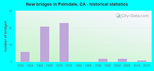
- New bridges - historical statistics
- 61950-1959
- 211960-1969
- 231970-1979
- 21990-1999
- 22000-2009
- 12010-2019
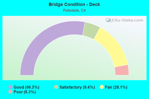
- Bridge Condition - Deck
- 56.3%Good
- 9.4%Satisfactory
- 28.1%Fair
- 6.3%Poor
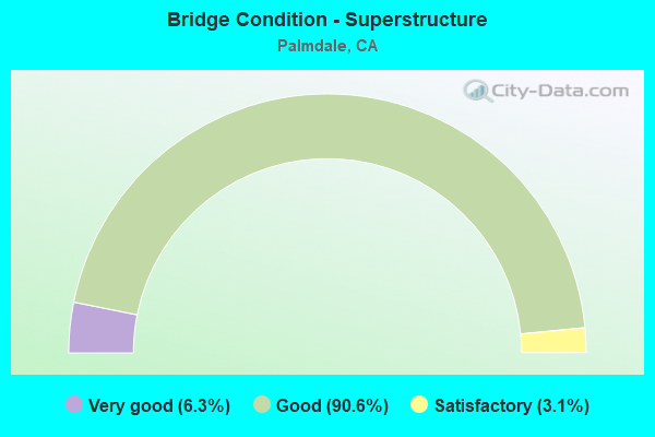
- Bridge Condition - Superstructure
- 6.3%Very good
- 90.6%Good
- 3.1%Satisfactory
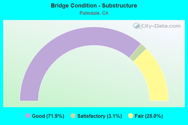
- Bridge Condition - Substructure
- 71.9%Good
- 3.1%Satisfactory
- 25.0%Fair
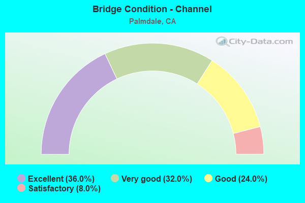
- Bridge Condition - Channel
- 36.0%Excellent
- 32.0%Very good
- 24.0%Good
- 8.0%Satisfactory
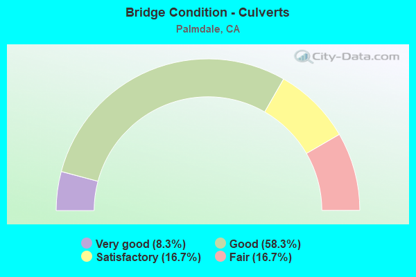
- Bridge Condition - Culverts
- 8.3%Very good
- 58.3%Good
- 16.7%Satisfactory
- 16.7%Fair
Find on map >> Show street view
Structure Number: AF69TTQK002501, Location: Site 2 North Entrance/20t (Lat: 34.645267, Lng: -118.093328), Route carried "on" structure: ServiceOther road , Year Built: 1954, Status: Open, Structure Length: 0.64m (2.10ft), Average Daily Traffic: 20 (year 2017), Average Future Daily Traffic: 24 (year 2037), Features Intersected: ANAVERDE CREEK, Facility Carried by Structure: SITE 2 NORTH ACCES
Minimum Vertical Clearance: 30+ m (98+ ft), Kilometerpoint: 0.000, Lanes on structure: 2, Owner: Air Force, Approaching Roadway Width: 8.9m (29.2ft), Material/Design: Concrete, Design/Construction: Culvert, Number Of Spans In Main Unit: 2, Length of Maximum Span: 3.0m (9.8ft)
Condition: Channel: Satisfactory, Culverts: Satisfactory, Operating Rating: 40.9 metric tons, Method Used To Determine Operating Rating: Field evaluation and documented engineering judgment, Inventory Rating: 24.5 metric tons, Method Used To Determine Inventory Rating: Field evaluation and documented engineering judgment, Structural Evaluation: Equal to present minimum criteria, Waterway Adequacy: Equal to present desirable criteria, Approach Roadway Alignment: Equal to present desirable criteria, Designated Inspection Frequency: Every 24 months, Inspection Date: August 2021, Bridge Improvement Cost: $50,000, Roadway Improvement Cost: $5,000, Total Project Cost: $75,000 ( Estimate for 2017)
Find on map >> Show street view
Structure Number: AF69TTQK009606, Location: 0.1 miles north of 25th S (Lat: 34.609617, Lng: -118.085367), Route carried "on" structure: ServiceOther road , Year Built: 1954, Status: Open, Structure Length: 0.97m (3.18ft), Average Daily Traffic: 40 (year 2017), Average Future Daily Traffic: 48 (year 2037), Features Intersected: DRAINAGE DITCH, Facility Carried by Structure: 25TH STREET ENTRY
Minimum Vertical Clearance: 30+ m (98+ ft), Kilometerpoint: 0.000, Lanes on structure: 2, Owner: Air Force, Approaching Roadway Width: 8.2m (26.9ft), Design/Construction: Culvert, Number Of Spans In Main Unit: 6, Length of Maximum Span: 0.9m (3.0ft)
Condition: Channel: Good, Culverts: Good, Operating Rating: 40.8 metric tons, Method Used To Determine Operating Rating: Field evaluation and documented engineering judgment, Inventory Rating: 24.5 metric tons, Method Used To Determine Inventory Rating: Field evaluation and documented engineering judgment, Structural Evaluation: Equal to present minimum criteria, Waterway Adequacy: Equal to present desirable criteria, Approach Roadway Alignment: Equal to present desirable criteria, Designated Inspection Frequency: Every 24 months, Inspection Date: August 2021, Bridge Improvement Cost: $20,000, Roadway Improvement Cost: $2,000, Total Project Cost: $30,000 ( Estimate for 2017)
Find on map >> Show street view
Structure Number: AF69TTQK009607, Location: East of Taxiway Sierra at (Lat: 34.624511, Lng: -118.072472), Route carried "on" structure: ServiceOther road , Year Built: 1954, Status: Open, Structure Length: 0.85m (2.79ft), Average Daily Traffic: 10 (year 2017), Average Future Daily Traffic: 12 (year 2037), Features Intersected: DRAINAGE DITCH, Facility Carried by Structure: PERIMETER ROAD
Minimum Vertical Clearance: 30+ m (98+ ft), Kilometerpoint: 0.000, Lanes on structure: 2, Owner: Air Force, Approaching Roadway Width: 9.8m (32.2ft), Skew: 2 degrees, Material/Design: Steel, Design/Construction: Culvert, Number Of Spans In Main Unit: 7, Length of Maximum Span: 0.9m (3.0ft)
Condition: Channel: Good, Culverts: Satisfactory, Operating Rating: 40.9 metric tons, Method Used To Determine Operating Rating: Field evaluation and documented engineering judgment, Inventory Rating: 24.5 metric tons, Method Used To Determine Inventory Rating: Field evaluation and documented engineering judgment, Structural Evaluation: Equal to present minimum criteria, Waterway Adequacy: Better than present minimum criteria, Approach Roadway Alignment: Equal to present desirable criteria, Designated Inspection Frequency: Every 24 months, Inspection Date: August 2021, Bridge Improvement Cost: $20,000, Roadway Improvement Cost: $2,000, Total Project Cost: $30,000 ( Estimate for 2017)
Find on map >> Show street view
Structure Number: 53 1419, Location: 07-LA-014-R59.78-PMDL (Lat: 34.580964, Lng: -118.133525), Route carried "under" structure: State highway 138, Year Built: 1966, Structure Length: 0. m, Average Daily Traffic: 33,250 (year 2017), Truck Traffic: 5%, Features Intersected: STATE RTE 138, Facility Carried by Structure: STATE RTE 14
Minimum Vertical Clearance: 4.47m (14.67ft), Kilometerpoint: 43.420, Lanes on structure: 8, Lanes under structure: 5, Material/Design: Concrete continuous, Design/Construction: Tee Beam, Length of Maximum Span: 18.1m (59.4ft)
Find on map >> Show street view
Structure Number: 53 1794, Location: 07-LA-014-R57.37 (Lat: 34.546033, Lng: -118.130739), Route carried "under" structure: State highway 14, Year Built: 1966, Structure Length: 0. m, Average Daily Traffic: 80,000 (year 2017), Truck Traffic: 5%, Features Intersected: CALIFORNIA AQUEDUCT,RT14, Facility Carried by Structure: BARREL SPRG RD OC
Minimum Vertical Clearance: 5.13m (16.83ft), Kilometerpoint: 57.370, Lanes on structure: 2, Lanes under structure: 5, Material/Design: Concrete continuous, Design/Construction: Box Beam or Girders - Multiple, Length of Maximum Span: 30.2m (99.1ft)
Find on map >> Show street view
Structure Number: 53 2033, Location: 07-LA-138-51.06 (Lat: 34.546169, Lng: -118.034625), Route carried "under" structure: State highway 138, Year Built: 1967, Structure Length: 0. m, Average Daily Traffic: 37,000 (year 2009), Truck Traffic: 4%, Features Intersected: ST RTE 138 (FT TEJON RD), Facility Carried by Structure: UP RR
Minimum Vertical Clearance: 4.55m (14.93ft), Kilometerpoint: 51.060, Lanes under structure: 4, Material/Design: Steel, Design/Construction: Girder and Floorbeam System, Length of Maximum Span: 23.5m (77.1ft)
Find on map >> Show street view
Structure Number: 53 2178L, Location: 07-LA-014-R60.70-PMDL (Lat: 34.594278, Lng: -118.134581), Route carried "under" structure: City street Q012, Year Built: 1972, Structure Length: 0. m, Average Daily Traffic: 3,500 (year 2017), Truck Traffic: 2%, Features Intersected: TECHNOLOGY DRIVE, Facility Carried by Structure: STATE ROUTE 14
Minimum Vertical Clearance: 5.03m (16.50ft), Kilometerpoint: 0.000, Lanes on structure: 3, Lanes under structure: 4, Material/Design: Prestressed concrete, Design/Construction: Box Beam or Girders - Multiple, Length of Maximum Span: 40.6m (133.2ft)
Find on map >> Show street view
Structure Number: 53 2178R, Location: 07-LA-014-R60.70-PMDL (Lat: 34.594267, Lng: -118.134269), Route carried "under" structure: City street Q012, Year Built: 1972, Structure Length: 0. m, Average Daily Traffic: 3,500 (year 2017), Truck Traffic: 2%, Features Intersected: TECHNOLOGY DRIVE, Facility Carried by Structure: STATE ROUTE 14
Minimum Vertical Clearance: 5.79m (19.00ft), Kilometerpoint: 0.000, Lanes on structure: 3, Lanes under structure: 4, Material/Design: Prestressed concrete, Design/Construction: Box Beam or Girders - Multiple, Length of Maximum Span: 43.2m (141.7ft)
Find on map >> Show street view
Structure Number: 53 2179, Location: 07-LA-014-R62.66 (Lat: 34.616444, Lng: -118.153692), Route carried "under" structure: State highway 14, Year Built: 1970, Structure Length: 0. m, Average Daily Traffic: 89,000 (year 2017), Truck Traffic: 5%, Features Intersected: ROUTE 14, Facility Carried by Structure: AVENUE "O"
Minimum Vertical Clearance: 5.13m (16.83ft), Kilometerpoint: 62.660, Lanes on structure: 2, Lanes under structure: 6, Material/Design: Prestressed concrete continuous, Design/Construction: Box Beam or Girders - Multiple, Length of Maximum Span: 36.9m (121.1ft)
Find on map >> Show street view
Structure Number: 53 2222, Location: 07-LA-014-R63.67 (Lat: 34.631044, Lng: -118.153617), Route carried "under" structure: State highway 14, Year Built: 1970, Structure Length: 0. m, Average Daily Traffic: 92,000 (year 2017), Truck Traffic: 5%, Features Intersected: ROUTE 14, Facility Carried by Structure: AVENUE "N"
Minimum Vertical Clearance: 5.03m (16.50ft), Kilometerpoint: 63.670, Lanes on structure: 2, Lanes under structure: 8, Material/Design: Prestressed concrete continuous, Design/Construction: Box Beam or Girders - Multiple, Length of Maximum Span: 41.8m (137.1ft)
Find on map >> Show street view
Structure Number: 53 2376L, Location: 07-LA-014-R61.37-PMDL (Lat: 34.601508, Lng: -118.142433), Route carried "under" structure: City street Q014, Year Built: 1972, Structure Length: 0. m, Average Daily Traffic: 9,800 (year 2017), Truck Traffic: 2%, Features Intersected: RANCHO VISTA BOULEVARD, Facility Carried by Structure: ROUTE 14 SB
Minimum Vertical Clearance: 5.18m (16.99ft), Kilometerpoint: 0.000, Lanes on structure: 3, Lanes under structure: 6, Material/Design: Prestressed concrete continuous, Design/Construction: Box Beam or Girders - Multiple, Length of Maximum Span: 48.0m (157.5ft)
Find on map >> Show street view
Structure Number: 53 2376R, Location: 07-LA-014-R61.37-PMDL (Lat: 34.601506, Lng: -118.142003), Route carried "under" structure: City street Q014, Year Built: 1972, Structure Length: 0. m, Average Daily Traffic: 9,800 (year 2017), Truck Traffic: 2%, Features Intersected: RANCHO VISTA BOULEVARD, Facility Carried by Structure: ROUTE 14 NB
Minimum Vertical Clearance: 5.46m (17.91ft), Kilometerpoint: 0.000, Lanes on structure: 3, Lanes under structure: 6, Material/Design: Prestressed concrete continuous, Design/Construction: Box Beam or Girders - Multiple, Length of Maximum Span: 48.0m (157.5ft)
Find on map >> Show street view
Structure Number: 53C0324, Location: 1.0MI S/O PALMDALE BLVD (Lat: 34.567331, Lng: -118.115000), Route carried "under" structure: City street L639, Year Built: 1967, Structure Length: 0. m, Average Daily Traffic: 7,242 (year 2012), Truck Traffic: 3%, Features Intersected: SIERRA HWY, Facility Carried by Structure: SP/UP RR
Minimum Vertical Clearance: 4.52m (14.83ft), Kilometerpoint: 0.000, Lanes under structure: 4, Material/Design: Prestressed concrete, Design/Construction: Box Beam or Girders - Multiple, Length of Maximum Span: 17.7m (58.1ft)
Find on map >> Show street view
Structure Number: 53C081, Location: 0.3MI S/O AVE S (Lat: 34.554953, Lng: -118.086069), Route carried "under" structure: City street Q026, Year Built: 1967, Structure Length: 0. m, Average Daily Traffic: 24,960 (year 2012), Truck Traffic: 2%, Features Intersected: 25TH ST E, Facility Carried by Structure: SPTC RR
Minimum Vertical Clearance: 4.57m (14.99ft), Kilometerpoint: 0.000, Lanes under structure: 4, Material/Design: Prestressed concrete, Design/Construction: Box Beam or Girders - Multiple, Length of Maximum Span: 14.9m (48.9ft)