Bridge Statistics for Oxnard, California (CA)
Condition, Traffic, Stress, Structural Evaluation, Project Costs
- New bridges - historical statistics
- 31920-1929
- 21930-1939
- 201950-1959
- 91960-1969
- 81970-1979
- 71980-1989
- 21990-1999
- 132000-2009
- 22010-2019
- Reconstructed bridges - Historical Statistics
- 31950-1959
- 21960-1969
- 11970-1979
- 31980-1989
- 31990-1999
- 02000-2009
- 12010-2019
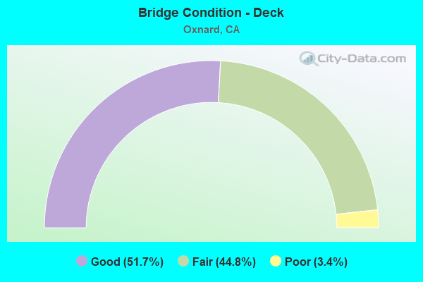
- Bridge Condition - Deck
- 51.7%Good
- 44.8%Fair
- 3.4%Poor
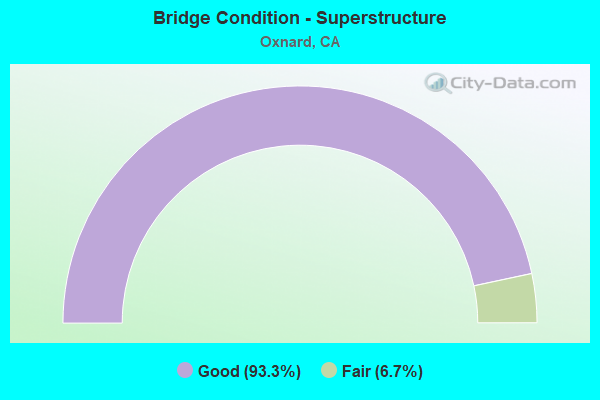
- Bridge Condition - Superstructure
- 93.3%Good
- 6.7%Fair
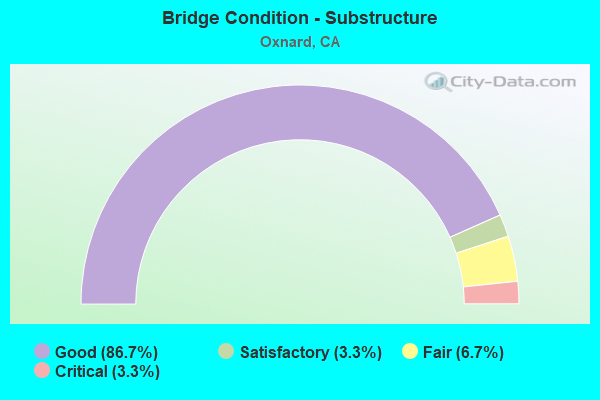
- Bridge Condition - Substructure
- 86.7%Good
- 3.3%Satisfactory
- 6.7%Fair
- 3.3%Critical
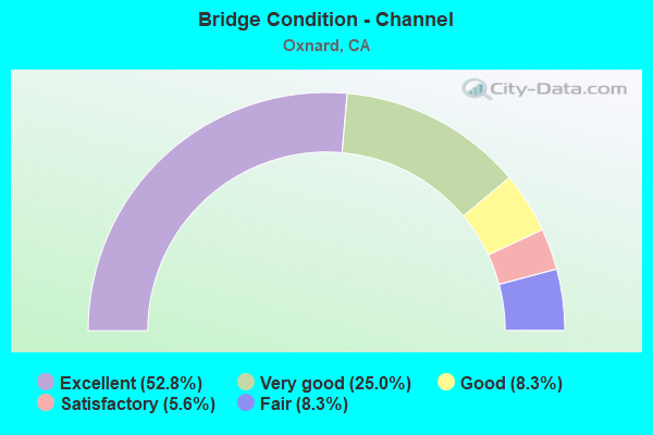
- Bridge Condition - Channel
- 52.8%Excellent
- 25.0%Very good
- 8.3%Good
- 5.6%Satisfactory
- 8.3%Fair
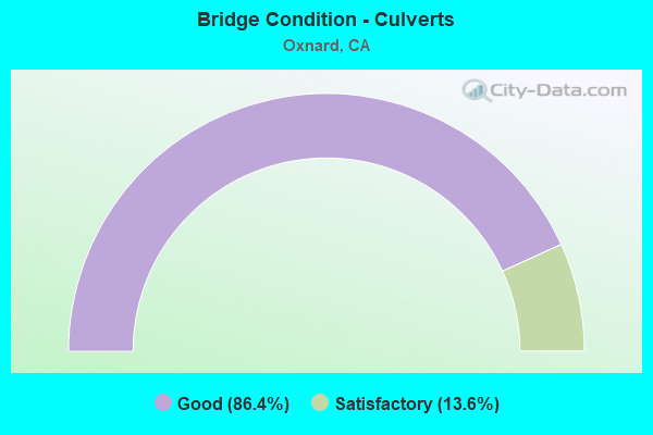
- Bridge Condition - Culverts
- 86.4%Good
- 13.6%Satisfactory
Find on map >> Show street view
Structure Number: 52C0216, Location: 0.5 MI E. OF VENTURA RD. (Lat: 34.170511, Lng: -119.185844), Route carried "on" structure: City street , Year Built: 1950, Status: Open, Structure Length: 0.79m (2.59ft), Average Daily Traffic: 2,000 (year 2020), Truck Traffic: 2%, Average Future Daily Traffic: 2,401 (year 2038), Features Intersected: J STREET DRAIN, Facility Carried by Structure: TEAKWOOD ST
Minimum Vertical Clearance: 30+ m (98+ ft), Kilometerpoint: 0.000, Lanes on structure: 2, Owner: City or Municipal Highway Agency, Approaching Roadway Width: 12.2m (40.0ft), Material/Design: Concrete, Design/Construction: Culvert, Number Of Spans In Main Unit: 3, Length of Maximum Span: 2.4m (7.9ft), Curb or Sidewalk Widths: Left: 1.2m (3.9ft), Right: 1.2m (3.9ft), Curb-To-Curb Width: 13.6m (44.6ft), Out-to-Out Width: 15.2m (49.9ft)
Condition: Channel: Excellent, Culverts: Satisfactory, Operating Rating: 40.5 metric tons, Method Used To Determine Operating Rating: Field evaluation and documented engineering judgment, Inventory Rating: 24.3 metric tons, Method Used To Determine Inventory Rating: Field evaluation and documented engineering judgment, Structural Evaluation: Equal to present minimum criteria, Deck Geometry: Superior to present desirable criteria, Waterway Adequacy: Superior to present desirable criteria, Approach Roadway Alignment: Equal to present desirable criteria, Designated Inspection Frequency: Every 24 months, Inspection Date: August 2020
Find on map >> Show street view
Structure Number: 52C0217, Location: 0.5 MI E OF VENTURA RD (Lat: 34.173383, Lng: -119.185811), Route carried "on" structure: City street , Year Built: 1950, Status: Open, Structure Length: 0.79m (2.59ft), Average Daily Traffic: 1,000 (year 2020), Truck Traffic: 2%, Average Future Daily Traffic: 1,253 (year 2038), Features Intersected: J STREET DRAIN, Facility Carried by Structure: REDWOOD ST
Minimum Vertical Clearance: 30+ m (98+ ft), Kilometerpoint: 0.000, Lanes on structure: 2, Owner: City or Municipal Highway Agency, Approaching Roadway Width: 12.2m (40.0ft), Material/Design: Concrete, Design/Construction: Culvert, Number Of Spans In Main Unit: 3, Length of Maximum Span: 2.4m (7.9ft), Curb or Sidewalk Widths: Left: 1.4m (4.6ft), Right: 1.2m (3.9ft), Curb-To-Curb Width: 12.3m (40.4ft), Out-to-Out Width: 15.3m (50.2ft)
Condition: Channel: Excellent, Culverts: Good, Operating Rating: 40.5 metric tons, Method Used To Determine Operating Rating: Field evaluation and documented engineering judgment, Inventory Rating: 24.3 metric tons, Method Used To Determine Inventory Rating: Field evaluation and documented engineering judgment, Structural Evaluation: Equal to present minimum criteria, Deck Geometry: Superior to present desirable criteria, Waterway Adequacy: Superior to present desirable criteria, Approach Roadway Alignment: Equal to present desirable criteria, Designated Inspection Frequency: Every 24 months, Inspection Date: August 2020
Find on map >> Show street view
Structure Number: 52C0218, Location: 0.1 MI N OF HUENEME RD (Lat: 34.148236, Lng: -119.172986), Route carried "on" structure: City street , Year Built: 1969, Status: Open, Structure Length: 2.68m (8.79ft), Average Daily Traffic: 2,000 (year 2020), Truck Traffic: 2%, Average Future Daily Traffic: 2,610 (year 2038), Features Intersected: OXNARD INDUSTRIAL DRAIN, Facility Carried by Structure: CYPRESS ROAD
Minimum Vertical Clearance: 30+ m (98+ ft), Kilometerpoint: 0.000, Lanes on structure: 2, Owner: City or Municipal Highway Agency, Approaching Roadway Width: 6.7m (22.0ft), Skew: 4 degrees, Material/Design: Concrete, Design/Construction: Culvert, Number Of Spans In Main Unit: 4, Length of Maximum Span: 6.9m (22.6ft), Curb or Sidewalk Widths: Left: 2.1m (6.9ft), Right: 2.1m (6.9ft), Curb-To-Curb Width: 10.6m (34.8ft), Out-to-Out Width: 15.4m (50.5ft)
Condition: Channel: Excellent, Culverts: Good, Operating Rating: 40.5 metric tons, Method Used To Determine Operating Rating: Field evaluation and documented engineering judgment, Inventory Rating: 24.3 metric tons, Method Used To Determine Inventory Rating: Field evaluation and documented engineering judgment, Structural Evaluation: Equal to present minimum criteria, Deck Geometry: Equal to present minimum criteria, Waterway Adequacy: Superior to present desirable criteria, Approach Roadway Alignment: Equal to present desirable criteria, Designated Inspection Frequency: Every 24 months, Inspection Date: August 2020
Find on map >> Show street view
Structure Number: 52C0219, Location: N OF PLEASANT VALLEY RD (Lat: 34.155322, Lng: -119.165314), Route carried "on" structure: City street , Year Built: 1965, Status: Open, Structure Length: 1.01m (3.31ft), Average Daily Traffic: 1,500 (year 2020), Truck Traffic: 2%, Average Future Daily Traffic: 1,880 (year 2038), Design Load: H 15, Features Intersected: RICE ROAD DRAIN I, Facility Carried by Structure: TERRACE AVE
Minimum Vertical Clearance: 30+ m (98+ ft), Kilometerpoint: 0.000, Lanes on structure: 2, Owner: City or Municipal Highway Agency, Approaching Roadway Width: 9.8m (32.2ft), Material/Design: Concrete, Design/Construction: Culvert, Number Of Spans In Main Unit: 3, Length of Maximum Span: 3.0m (9.8ft), Curb-To-Curb Width: 12.0m (39.4ft), Out-to-Out Width: 18.6m (61.0ft)
Condition: Channel: Excellent, Culverts: Good, Operating Rating: 40.5 metric tons, Method Used To Determine Operating Rating: Field evaluation and documented engineering judgment, Inventory Rating: 24.3 metric tons, Method Used To Determine Inventory Rating: Field evaluation and documented engineering judgment, Structural Evaluation: Equal to present minimum criteria, Deck Geometry: Equal to present minimum criteria, Waterway Adequacy: Superior to present desirable criteria, Approach Roadway Alignment: Equal to present desirable criteria, Designated Inspection Frequency: Every 24 months, Inspection Date: August 2020
Find on map >> Show street view
Structure Number: 52C0251, Location: 0.1 MI W PARKVIEW DR. (Lat: 34.173919, Lng: -118.763692), Route carried "on" structure: County highway , Year Built: 1980, Status: Open, Structure Length: 0.98m (3.22ft), Average Daily Traffic: 500 (year 2017), Truck Traffic: 2%, Average Future Daily Traffic: 737 (year 2038), Features Intersected: MEDEA CREEK, Facility Carried by Structure: N. OAK HILLS DR
Minimum Vertical Clearance: 30+ m (98+ ft), Kilometerpoint: 0.000, Lanes on structure: 2, Owner: County Highway Agency, Approaching Roadway Width: 11.0m (36.1ft), Skew: 1 degrees, Material/Design: Steel, Design/Construction: Culvert, Number Of Spans In Main Unit: 1, Length of Maximum Span: 9.8m (32.2ft), Curb or Sidewalk Widths: Left: 1.5m (4.9ft), Right: 1.5m (4.9ft)
Condition: Channel: Fair, Culverts: Satisfactory, Operating Rating: 54.1 metric tons, Method Used To Determine Operating Rating: Field evaluation and documented engineering judgment, Inventory Rating: 32.4 metric tons, Method Used To Determine Inventory Rating: Field evaluation and documented engineering judgment, Structural Evaluation: Equal to present minimum criteria, Waterway Adequacy: Superior to present desirable criteria, Approach Roadway Alignment: Equal to present minimum criteria, Designated Inspection Frequency: Every 24 months, Inspection Date: October 2020
Find on map >> Show street view
Structure Number: 52C0258, Location: 50 FT W OF VENTURA RD (Lat: 34.186267, Lng: -119.195158), Route carried "on" structure: City street , Year Built: 1950, Status: Open, Structure Length: 0.79m (2.59ft), Average Daily Traffic: 2,740 (year 2018), Truck Traffic: 2%, Average Future Daily Traffic: 3,133 (year 2038), Features Intersected: OXNARD WEST DRAIN, Facility Carried by Structure: HILL ST
Minimum Vertical Clearance: 30+ m (98+ ft), Kilometerpoint: 0.000, Lanes on structure: 2, Owner: City or Municipal Highway Agency, Approaching Roadway Width: 12.2m (40.0ft), Material/Design: Concrete, Design/Construction: Culvert, Number Of Spans In Main Unit: 2, Length of Maximum Span: 3.7m (12.1ft)
Condition: Channel: Excellent, Culverts: Good, Operating Rating: 40.5 metric tons, Method Used To Determine Operating Rating: Field evaluation and documented engineering judgment, Inventory Rating: 24.3 metric tons, Method Used To Determine Inventory Rating: Field evaluation and documented engineering judgment, Structural Evaluation: Equal to present minimum criteria, Waterway Adequacy: Superior to present desirable criteria, Approach Roadway Alignment: Equal to present desirable criteria, Designated Inspection Frequency: Every 24 months, Inspection Date: August 2020
Find on map >> Show street view
Structure Number: 52C0301, Location: 0.5 MI S/O LOS ANGELES AV (Lat: 34.272097, Lng: -118.900650), Route carried "on" structure: City street , Year Built: 1990, Status: Open, Structure Length: 10.64m (34.91ft), Average Daily Traffic: 8,640 (year 2020), Truck Traffic: 1%, Average Future Daily Traffic: 12,000 (year 2038), Features Intersected: ARROYO SIMI, Facility Carried by Structure: TIERRA REJADA RD.
Minimum Vertical Clearance: 30+ m (98+ ft), Kilometerpoint: 0.000, Lanes on structure: 4, Owner: City or Municipal Highway Agency, Approaching Roadway Width: 20.0m (65.6ft), Skew: 22 degrees, Material/Design: Concrete continuous, Design/Construction: Box Beam or Girders - Multiple, Number Of Spans In Main Unit: 3, Length of Maximum Span: 35.2m (115.5ft), Curb or Sidewalk Widths: Left: 1.4m (4.6ft), Right: 1.4m (4.6ft), Curb-To-Curb Width: 21.2m (69.6ft), Out-to-Out Width: 25.8m (84.6ft)
Condition: Deck: Poor, Superstructure: Good, Substructure: Good, Channel: Very good, Operating Rating: 54.1 metric tons, Method Used To Determine Operating Rating: Field evaluation and documented engineering judgment, Inventory Rating: 32.4 metric tons, Method Used To Determine Inventory Rating: Field evaluation and documented engineering judgment, Structural Evaluation: Better than present minimum criteria, Deck Geometry: Superior to present desirable criteria, Waterway Adequacy: Equal to present desirable criteria, Approach Roadway Alignment: Equal to present minimum criteria, Designated Inspection Frequency: Every 24 months, Inspection Date: August 2020, Deck Structure Type: Concrete Cast-file-Place
Find on map >> Show street view
Structure Number: 52C0306, Location: .25 MI WEST OF S.ROSE AVE (Lat: 34.172503, Lng: -119.156994), Route carried "on" structure: City street , Year Built: 1957, Status: Open, Structure Length: 9.88m (32.41ft), Average Daily Traffic: 6,250 (year 2011), Truck Traffic: 1%, Average Future Daily Traffic: 8,471 (year 2040), Design Load: HS 20, Features Intersected: OXNARD BLVD, Facility Carried by Structure: CHANNEL ISLAND BL
Minimum Vertical Clearance: 30+ m (98+ ft), Kilometerpoint: 0.000, Lanes on structure: 2, Lanes under structure: 6, Owner: City or Municipal Highway Agency, Approaching Roadway Width: 7.9m (25.9ft), Skew: 4 degrees, Material/Design: Concrete continuous, Design/Construction: Box Beam or Girders - Multiple, Number Of Spans In Main Unit: 4, Length of Maximum Span: 34.1m (111.9ft), Curb or Sidewalk Widths: Left: 0.0m, Right: 1.2m (3.9ft), Curb-To-Curb Width: 7.9m (25.9ft), Out-to-Out Width: 10.2m (33.5ft)
Condition: Deck: Good, Superstructure: Good, Substructure: Good, Operating Rating: 39.9 metric tons, Method Used To Determine Operating Rating: Load and Resistance Factor Rating (LRFR) rating reported by rating factor(RF) method using HL-93 loadings, Inventory Rating: 29.2 metric tons, Method Used To Determine Inventory Rating: Load and Resistance Factor Rating (LRFR) rating reported by rating factor(RF) method using HL-93 loadings, Structural Evaluation: Better than present minimum criteria, Deck Geometry: High priority of corrective action, Underclear: High priority of corrective action, Approach Roadway Alignment: Equal to present desirable criteria, Designated Inspection Frequency: Every 24 months, Inspection Date: August 2020, Deck Structure Type: Concrete Cast-file-Place
Find on map >> Show street view
Structure Number: 52C0307, Location: 500 FT NORTH OF W.4TH ST (Lat: 34.200297, Lng: -119.177525), Route carried "on" structure: City street , Year Built: 1987, Status: Open, Structure Length: 20.24m (66.40ft), Average Daily Traffic: 5,500 (year 2011), Truck Traffic: 1%, Average Future Daily Traffic: 8,257 (year 2040), Design Load: HS 20+Mod, Features Intersected: UP RR, AMTRAK, OXNARD BL, Facility Carried by Structure: THIRD ST
Minimum Vertical Clearance: 30+ m (98+ ft), Kilometerpoint: 0.000, Lanes on structure: 2, Lanes under structure: 4, Owner: City or Municipal Highway Agency, Approaching Roadway Width: 19.5m (64.0ft), Material/Design: Prestressed concrete continuous, Design/Construction: Box Beam or Girders - Multiple, Number Of Spans In Main Unit: 7, Length of Maximum Span: 32.0m (105.0ft), Curb or Sidewalk Widths: Left: 2.0m (6.6ft), Right: 0.0m, Curb-To-Curb Width: 19.5m (64.0ft), Out-to-Out Width: 22.3m (73.2ft)
Condition: Deck: Good, Superstructure: Good, Substructure: Good, Operating Rating: 54.1 metric tons, Method Used To Determine Operating Rating: Assigned rating based on Load Factor Design (LFD) reported in metric tons, Inventory Rating: 32.4 metric tons, Method Used To Determine Inventory Rating: Assigned rating based on Load Factor Design (LFD) reported in metric tons, Structural Evaluation: Better than present minimum criteria, Deck Geometry: Superior to present desirable criteria, Underclear: Equal to present minimum criteria, Approach Roadway Alignment: Equal to present desirable criteria, Designated Inspection Frequency: Every 24 months, Inspection Date: August 2020, Deck Structure Type: Concrete Cast-file-Place
Find on map >> Show street view
Structure Number: 52C0308, Location: 500 FT N OF VINEYARD AVE (Lat: 34.227989, Lng: -119.177719), Route carried "on" structure: City street , Year Built: 1964, Year Reconstructed: 1990, Status: Open, Structure Length: 0.73m (2.40ft), Average Daily Traffic: 26,000 (year 2011), Truck Traffic: 5%, Average Future Daily Traffic: 36,247 (year 2036), Features Intersected: EL RIO DRAIN, Facility Carried by Structure: OXNARD BLVD
Minimum Vertical Clearance: 30+ m (98+ ft), Kilometerpoint: 0.000, Lanes on structure: 6, Base Highway Network: Yes (, Subroute: 1), Owner: City or Municipal Highway Agency, Approaching Roadway Width: 26.8m (87.9ft), Skew: 32 degrees, Material/Design: Concrete, Design/Construction: Culvert, Number Of Spans In Main Unit: 2, Length of Maximum Span: 3.0m (9.8ft), Curb-To-Curb Width: 26.8m (87.9ft), Out-to-Out Width: 30.9m (101.4ft)
Condition: Channel: Very good, Culverts: Good, Operating Rating: 54.1 metric tons, Method Used To Determine Operating Rating: Field evaluation and documented engineering judgment, Inventory Rating: 32.4 metric tons, Method Used To Determine Inventory Rating: Field evaluation and documented engineering judgment, Structural Evaluation: Better than present minimum criteria, Deck Geometry: Better than present minimum criteria, Waterway Adequacy: Equal to present desirable criteria, Approach Roadway Alignment: Equal to present desirable criteria, Designated Inspection Frequency: Every 48 months, Inspection Date: July 2018
Find on map >> Show street view
Structure Number: 52C031, Location: 500 FT SOUTH OF SPUR DR (Lat: 34.233592, Lng: -119.179869), Route carried "on" structure: City street , Year Built: 1955, Status: Open, Structure Length: 4.69m (15.39ft), Average Daily Traffic: 3,500 (year 2011), Truck Traffic: 1%, Average Future Daily Traffic: 5,425 (year 2040), Design Load: HS 20, Features Intersected: OXNARD BLVD, Facility Carried by Structure: WAGON WHEEL ROAD
Minimum Vertical Clearance: 30+ m (98+ ft), Kilometerpoint: 0.000, Lanes on structure: 2, Lanes under structure: 4, Owner: City or Municipal Highway Agency, Approaching Roadway Width: 8.5m (27.9ft), Skew: 3 degrees, Material/Design: Steel, Design/Construction: Stringer/Multi-beam, Number Of Spans In Main Unit: 2, Number Of Approach Spans: 2, Length of Maximum Span: 15.2m (49.9ft), Curb or Sidewalk Widths: Left: 1.6m (5.2ft), Right: 0.6m (2.0ft), Curb-To-Curb Width: 8.5m (27.9ft), Out-to-Out Width: 11.2m (36.7ft)
Condition: Deck: Fair, Superstructure: Good, Substructure: Good, Operating Rating: 50.2 metric tons, Method Used To Determine Operating Rating: Load Factor (LF), Inventory Rating: 30.1 metric tons, Method Used To Determine Inventory Rating: Load Factor (LF), Structural Evaluation: Better than present minimum criteria, Deck Geometry: Meets minimum limits, Underclear: Somewhat better than minimum adequacy, Approach Roadway Alignment: Equal to present minimum criteria, Designated Inspection Frequency: Every 24 months, Inspection Date: August 2020, Deck Structure Type: Concrete Cast-file-Place
Find on map >> Show street view
Structure Number: 52 0188, Location: 07-VEN-232-0.43-OXN (Lat: 34.231353, Lng: -119.173389), Route carried "under" structure: US 101, Year Built: 1975, Structure Length: 0. m, Average Daily Traffic: 123,000 (year 2015), Truck Traffic: 8%, Features Intersected: US HIGHWAY 101, Facility Carried by Structure: STATE ROUTE 232
Minimum Vertical Clearance: 4.87m (15.98ft), Kilometerpoint: 22.000, Lanes on structure: 7, Lanes under structure: 10, Material/Design: Prestressed concrete continuous, Design/Construction: Box Beam or Girders - Multiple, Length of Maximum Span: 45.7m (149.9ft)
Find on map >> Show street view
Structure Number: 52 0192, Location: 07-VEN-001-11.59 (Lat: 34.133125, Lng: -119.098811), Route carried "under" structure: State highway 1, Year Built: 1957, Structure Length: 0. m, Average Daily Traffic: 10,400 (year 2020), Truck Traffic: 4%, Features Intersected: STATE ROUTE 1, Facility Carried by Structure: WOOD ROAD
Minimum Vertical Clearance: 4.62m (15.16ft), Kilometerpoint: 11.590, Lanes on structure: 2, Lanes under structure: 6, Material/Design: Concrete continuous, Design/Construction: Box Beam or Girders - Multiple, Length of Maximum Span: 21.3m (69.9ft)
Find on map >> Show street view
Structure Number: 52 0271, Location: 07-VEN-101-19.17-OXN (Lat: 34.221833, Lng: -119.126825), Route carried "under" structure: US 101, Year Built: 1964, Structure Length: 0. m, Average Daily Traffic: 144,000 (year 2018), Truck Traffic: 8%, Features Intersected: US HIGHWAY 101, Facility Carried by Structure: DEL NORTE BLVD
Minimum Vertical Clearance: 4.74m (15.55ft), Kilometerpoint: 19.170, Lanes on structure: 2, Lanes under structure: 6, Material/Design: Prestressed concrete, Design/Construction: Stringer/Multi-beam, Length of Maximum Span: 22.1m (72.5ft)
Find on map >> Show street view
Structure Number: 52 0438, Location: 07-VEN-101-21.01-OXN (Lat: 34.224658, Lng: -119.158581), Route carried "under" structure: US 101, Year Built: 2001, Structure Length: 0. m, Average Daily Traffic: 137,000 (year 2018), Truck Traffic: 2%, Features Intersected: US HIGHWAY 101, Facility Carried by Structure: ROSE AVENUE
Minimum Vertical Clearance: 6.27m (20.57ft), Kilometerpoint: 21.010, Lanes on structure: 7, Lanes under structure: 8, Material/Design: Concrete continuous, Design/Construction: Box Beam or Girders - Multiple, Length of Maximum Span: 47.0m (154.2ft)
Find on map >> Show street view
Structure Number: 52 0443, Location: 07-VEN-001-R15.01-OXN (Lat: 34.165936, Lng: -119.142831), Route carried "under" structure: State highway 1, Year Built: 2003, Structure Length: 0. m, Average Daily Traffic: 13,500 (year 2011), Truck Traffic: 4%, Features Intersected: STATE ROUTE 1, Facility Carried by Structure: PLEASANT VALLEY RO
Minimum Vertical Clearance: 5.51m (18.08ft), Kilometerpoint: 15.010, Lanes on structure: 5, Lanes under structure: 7, Material/Design: Prestressed concrete continuous, Design/Construction: Box Beam or Girders - Multiple, Length of Maximum Span: 28.9m (94.8ft)
Find on map >> Show street view
Structure Number: 52 0444S, Location: 07-VEN-001-R14.67-OXN (Lat: 34.160572, Lng: -119.137283), Route carried "under" structure: State highway 1, Year Built: 2003, Structure Length: 0. m, Average Daily Traffic: 8,200 (year 2020), Truck Traffic: 4%, Features Intersected: STATE ROUTE 1
Minimum Vertical Clearance: 5.28m (17.32ft), Kilometerpoint: 14.670, Lanes on structure: 2, Lanes under structure: 5, Material/Design: Prestressed concrete continuous, Design/Construction: Box Beam or Girders - Multiple, Length of Maximum Span: 57.5m (188.6ft)
Find on map >> Show street view
Structure Number: 52 0445K, Location: 07-VEN-001-R14.75-OXN (Lat: 34.161206, Lng: -119.138789), Route carried "under" structure: Ramp State highway 1, Year Built: 2003, Structure Length: 0. m, Average Daily Traffic: 8,200 (year 2020), Truck Traffic: 4%, Features Intersected: PLEASANT VALLEY-S001 ON
Minimum Vertical Clearance: 5.13m (16.83ft), Kilometerpoint: 14.750, Lanes on structure: 2, Lanes under structure: 2, Material/Design: Prestressed concrete continuous, Design/Construction: Box Beam or Girders - Multiple, Length of Maximum Span: 50.9m (167.0ft)
Find on map >> Show street view
Structure Number: 52 0449, Location: 07-VEN-101-R23.07 (Lat: 34.241736, Lng: -119.186758), Route carried "under" structure: City street , Year Built: 2007, Structure Length: 0. m, Average Daily Traffic: 15,000 (year 2020), Truck Traffic: 3%, Features Intersected: SANTA CLARA RIVER, Facility Carried by Structure: U.S. HIGHWAY 101
Minimum Vertical Clearance: 4.69m (15.39ft), Kilometerpoint: 0.000, Lanes on structure: 12, Lanes under structure: 4, Material/Design: Prestressed concrete continuous, Design/Construction: Box Beam or Girders - Multiple, Length of Maximum Span: 52.4m (171.9ft)
Find on map >> Show street view
Structure Number: 52 0454, Location: 07-VEN-101-21.98 (Lat: 34.238850, Lng: -119.180833), Route carried "under" structure: US 101, Year Built: 2004, Structure Length: 0. m, Average Daily Traffic: 136,000 (year 2020), Truck Traffic: 13%, Features Intersected: US HIGHWAY 101, Facility Carried by Structure: OXNARD BLVD
Minimum Vertical Clearance: 5.77m (18.93ft), Kilometerpoint: 21.980, Lanes on structure: 8, Lanes under structure: 10, Material/Design: Prestressed concrete continuous, Design/Construction: Box Beam or Girders - Multiple, Length of Maximum Span: 38.5m (126.3ft)
Find on map >> Show street view
Structure Number: 52 0456, Location: 07-VEN-101-20.08-OXN (Lat: 34.222294, Lng: -119.142172), Route carried "under" structure: US 101, Year Built: 2013, Structure Length: 0. m, Average Daily Traffic: 136,000 (year 2018), Truck Traffic: 13%, Features Intersected: ROUTE 101, Facility Carried by Structure: RICE AVENUE
Minimum Vertical Clearance: 5.61m (18.41ft), Kilometerpoint: 20.080, Lanes on structure: 8, Lanes under structure: 7, Material/Design: Prestressed concrete continuous, Design/Construction: Box Beam or Girders - Multiple, Length of Maximum Span: 34.3m (112.5ft)
Find on map >> Show street view
Structure Number: 52C0306, Location: .25 MI WEST OF S.ROSE AVE (Lat: 34.172503, Lng: -119.156994), Route carried "under" structure: State highway 1, Year Built: 1957, Structure Length: 0. m, Average Daily Traffic: 18,900 (year 2011), Truck Traffic: 4%, Features Intersected: OXNARD BLVD, Facility Carried by Structure: CHANNEL ISLAND BL
Minimum Vertical Clearance: 4.57m (14.99ft), Kilometerpoint: 15.930, Lanes on structure: 2, Lanes under structure: 6, Material/Design: Concrete continuous, Design/Construction: Box Beam or Girders - Multiple, Length of Maximum Span: 34.1m (111.9ft)
Find on map >> Show street view
Structure Number: 52C0307, Location: 500 FT NORTH OF W.4TH ST (Lat: 34.200297, Lng: -119.177525), Route carried "under" structure: State highway 1, Year Built: 1987, Structure Length: 0. m, Average Daily Traffic: 38,250 (year 2011), Truck Traffic: 3%, Features Intersected: UP RR, AMTRAK, OXNARD BL, Facility Carried by Structure: THIRD ST
Minimum Vertical Clearance: 4.75m (15.58ft), Kilometerpoint: 18.360, Lanes on structure: 2, Lanes under structure: 4, Material/Design: Prestressed concrete continuous, Design/Construction: Box Beam or Girders - Multiple, Length of Maximum Span: 32.0m (105.0ft)
Find on map >> Show street view
Structure Number: 52C0309, Location: 07-VEN-000-0.00-OXN (Lat: 34.233108, Lng: -119.179642), Route carried "under" structure: State highway 1, Year Built: 1931, Structure Length: 0. m, Average Daily Traffic: 26,000 (year 2011), Truck Traffic: 5%, Features Intersected: OXNARD BLVD, Facility Carried by Structure: SP/UP RR
Minimum Vertical Clearance: 4.77m (15.65ft), Kilometerpoint: 20.610, Lanes under structure: 4, Material/Design: Steel, Design/Construction: Girder and Floorbeam System, Length of Maximum Span: 20.1m (65.9ft)
Find on map >> Show street view
Structure Number: 52C031, Location: 500 FT SOUTH OF SPUR DR (Lat: 34.233592, Lng: -119.179869), Route carried "under" structure: State highway 1, Year Built: 1955, Structure Length: 0. m, Average Daily Traffic: 35,000 (year 2011), Truck Traffic: 5%, Features Intersected: OXNARD BLVD, Facility Carried by Structure: WAGON WHEEL ROAD
Minimum Vertical Clearance: 4.80m (15.75ft), Kilometerpoint: 20.650, Lanes on structure: 2, Lanes under structure: 4, Material/Design: Steel, Design/Construction: Stringer/Multi-beam, Length of Maximum Span: 15.2m (49.9ft)