Bridge Statistics for Orange, California (CA)
Condition, Traffic, Stress, Structural Evaluation, Project Costs
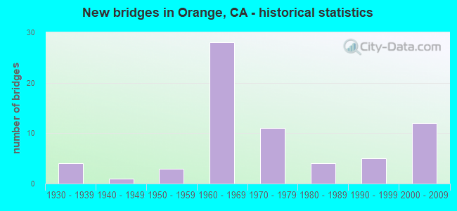
- New bridges - historical statistics
- 41930-1939
- 11940-1949
- 31950-1959
- 281960-1969
- 111970-1979
- 41980-1989
- 51990-1999
- 122000-2009
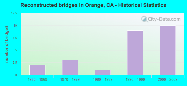
- Reconstructed bridges - Historical Statistics
- 21960-1969
- 31970-1979
- 11980-1989
- 91990-1999
- 102000-2009
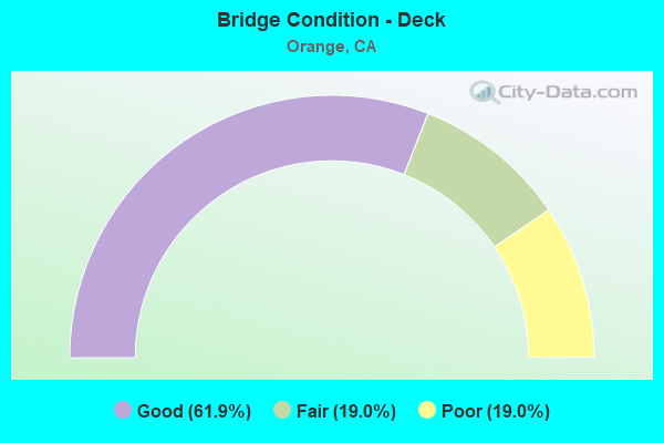
- Bridge Condition - Deck
- 61.9%Good
- 19.0%Fair
- 19.0%Poor
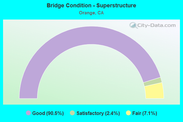
- Bridge Condition - Superstructure
- 90.5%Good
- 2.4%Satisfactory
- 7.1%Fair
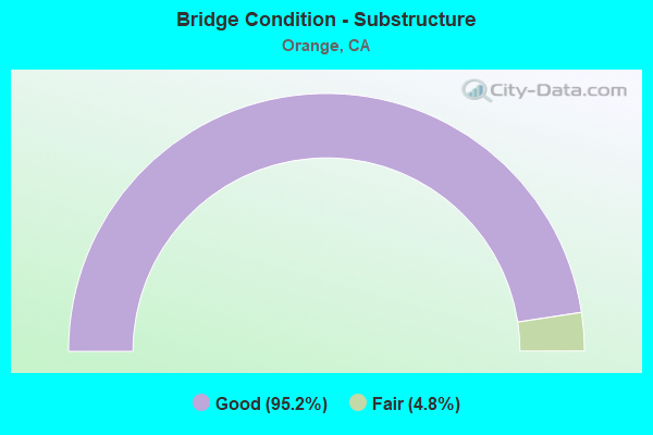
- Bridge Condition - Substructure
- 95.2%Good
- 4.8%Fair
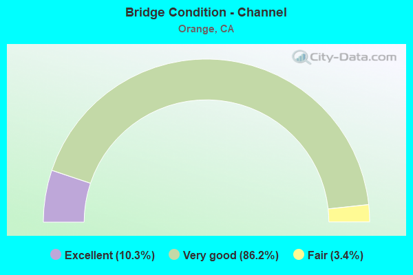
- Bridge Condition - Channel
- 10.3%Excellent
- 86.2%Very good
- 3.4%Fair
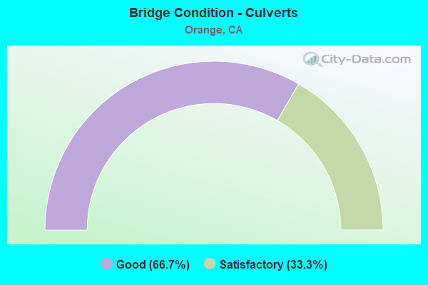
- Bridge Condition - Culverts
- 66.7%Good
- 33.3%Satisfactory
Find on map >> Show street view
Structure Number: 55 0033, Location: 12-ORA-055-13.42-ORA (Lat: 33.783881, Lng: -117.830728), Route carried "on" structure: State highway 55, Year Built: 1962, Year Reconstructed: 2002, Status: Open, Structure Length: 11.17m (36.65ft), Average Daily Traffic: 250,000 (year 2017), Truck Traffic: 6%, Average Future Daily Traffic: 375,000 (year 2038), Design Load: HS 20+Mod, Features Intersected: SANTIAGO CREEK
Minimum Vertical Clearance: 30+ m (98+ ft), Kilometerpoint: 13.420, Lanes on structure: 13, Base Highway Network: Yes (, Subroute: 1), Owner: State Highway Agency, Approaching Roadway Width: 60.4m (198.2ft), Skew: 35 degrees, Material/Design: Concrete continuous, Design/Construction: Box Beam or Girders - Multiple, Number Of Spans In Main Unit: 5, Length of Maximum Span: 25.8m (84.6ft), Curb-To-Curb Width: 60.4m (198.2ft), Out-to-Out Width: 62.2m (204.1ft)
Condition: Deck: Good, Superstructure: Good, Substructure: Good, Channel: Fair, Operating Rating: 82.0 metric tons, Method Used To Determine Operating Rating: Load Factor (LF), Inventory Rating: 49.2 metric tons, Method Used To Determine Inventory Rating: Load Factor (LF), Structural Evaluation: Better than present minimum criteria, Deck Geometry: Superior to present desirable criteria, Waterway Adequacy: Equal to present desirable criteria, Approach Roadway Alignment: Equal to present desirable criteria, Designated Inspection Frequency: Every 24 months, Inspection Date: March 2020, Deck Structure Type: Concrete Cast-file-Place
Find on map >> Show street view
Structure Number: 55 0171, Location: 12-ORA-057-11.24-ORA (Lat: 33.787683, Lng: -117.879611), Route carried "on" structure: State highway 57, Year Built: 1976, Year Reconstructed: 1998, Status: Open, Structure Length: 4.63m (15.19ft), Average Daily Traffic: 229,000 (year 2010), Truck Traffic: 8%, Average Future Daily Traffic: 265,000 (year 2040), Design Load: HS 20, Features Intersected: CHAPMAN AVE
Minimum Vertical Clearance: 30+ m (98+ ft), Kilometerpoint: 11.240, Lanes on structure: 13, Lanes under structure: 6, Base Highway Network: Yes (, Subroute: 1), Owner: State Highway Agency, Approaching Roadway Width: 58.2m (190.9ft), Skew: 30 degrees, Material/Design: Concrete continuous, Design/Construction: Box Beam or Girders - Multiple, Number Of Spans In Main Unit: 2, Length of Maximum Span: 22.9m (75.1ft), Curb-To-Curb Width: 58.2m (190.9ft), Out-to-Out Width: 62.7m (205.7ft)
Condition: Deck: Good, Superstructure: Good, Substructure: Good, Operating Rating: 54.1 metric tons, Method Used To Determine Operating Rating: Assigned rating based on Load Factor Design (LFD) reported in metric tons, Inventory Rating: 32.4 metric tons, Method Used To Determine Inventory Rating: Assigned rating based on Load Factor Design (LFD) reported in metric tons, Structural Evaluation: Better than present minimum criteria, Deck Geometry: Superior to present desirable criteria, Underclear: Meets minimum limits, Approach Roadway Alignment: Equal to present desirable criteria, Designated Inspection Frequency: Every 24 months, Inspection Date: May 2020, Deck Structure Type: Concrete Cast-file-Place
Find on map >> Show street view
Structure Number: 55 0324, Location: 12-ORA-055-15.24-ORA (Lat: 33.810033, Lng: -117.831678), Route carried "on" structure: State highway 55, Year Built: 1961, Year Reconstructed: 2002, Status: Open, Structure Length: 5.66m (18.57ft), Average Daily Traffic: 222,000 (year 2017), Truck Traffic: 6%, Average Future Daily Traffic: 275,000 (year 2038), Design Load: HS 20, Features Intersected: KATELLA AVE
Minimum Vertical Clearance: 30+ m (98+ ft), Kilometerpoint: 15.240, Lanes on structure: 10, Lanes under structure: 7, Base Highway Network: Yes (, Subroute: 1), Owner: State Highway Agency, Approaching Roadway Width: 51.0m (167.3ft), Skew: 31 degrees, Material/Design: Concrete continuous, Design/Construction: Box Beam or Girders - Multiple, Number Of Spans In Main Unit: 4, Length of Maximum Span: 18.6m (61.0ft), Curb-To-Curb Width: 51.0m (167.3ft), Out-to-Out Width: 52.6m (172.6ft)
Condition: Deck: Fair, Superstructure: Good, Substructure: Good, Operating Rating: 78.1 metric tons, Method Used To Determine Operating Rating: Load Factor (LF), Inventory Rating: 47.0 metric tons, Method Used To Determine Inventory Rating: Load Factor (LF), Structural Evaluation: Better than present minimum criteria, Deck Geometry: Superior to present desirable criteria, Underclear: High priority of corrective action, Approach Roadway Alignment: Equal to present desirable criteria, Designated Inspection Frequency: Every 24 months, Inspection Date: March 2020, Deck Structure Type: Concrete Cast-file-Place
Find on map >> Show street view
Structure Number: 55 0325, Location: 12-ORA-055-15.50-ORA (Lat: 33.813706, Lng: -117.831600), Route carried "on" structure: State highway 55, Year Built: 1961, Year Reconstructed: 2002, Status: Open, Structure Length: 3.72m (12.20ft), Average Daily Traffic: 211,000 (year 2009), Truck Traffic: 6%, Average Future Daily Traffic: 246,000 (year 2038), Design Load: HS 20, Features Intersected: NORTH ORANGE UC
Minimum Vertical Clearance: 30+ m (98+ ft), Kilometerpoint: 15.500, Lanes on structure: 14, Base Highway Network: Yes (, Subroute: 1), Owner: State Highway Agency, Approaching Roadway Width: 67.7m (222.1ft), Skew: 30 degrees, Material/Design: Concrete continuous, Design/Construction: Slab, Number Of Spans In Main Unit: 3, Length of Maximum Span: 12.2m (40.0ft), Curb-To-Curb Width: 67.7m (222.1ft), Out-to-Out Width: 69.3m (227.4ft)
Condition: Deck: Good, Superstructure: Good, Substructure: Good, Operating Rating: 54.1 metric tons, Method Used To Determine Operating Rating: Assigned rating based on Load Factor Design (LFD) reported in metric tons, Inventory Rating: 32.4 metric tons, Method Used To Determine Inventory Rating: Assigned rating based on Load Factor Design (LFD) reported in metric tons, Structural Evaluation: Better than present minimum criteria, Deck Geometry: Superior to present desirable criteria, Underclear: Equal to present minimum criteria, Approach Roadway Alignment: Equal to present desirable criteria, Designated Inspection Frequency: Every 48 months, Inspection Date: March 2018, Deck Structure Type: Concrete Cast-file-Place
Find on map >> Show street view
Structure Number: 55 0326, Location: 12-ORA-055-15.75-ORA (Lat: 33.817328, Lng: -117.831728), Route carried "on" structure: State highway 55, Year Built: 1961, Year Reconstructed: 2002, Status: Open, Structure Length: 4.85m (15.91ft), Average Daily Traffic: 220,000 (year 2017), Truck Traffic: 6%, Average Future Daily Traffic: 375,000 (year 2038), Design Load: HS 20+Mod, Features Intersected: TAFT AVENUE
Minimum Vertical Clearance: 30+ m (98+ ft), Kilometerpoint: 15.750, Lanes on structure: 11, Lanes under structure: 4, Base Highway Network: Yes (, Subroute: 1), Owner: State Highway Agency, Approaching Roadway Width: 56.7m (186.0ft), Skew: 30 degrees, Material/Design: Concrete continuous, Design/Construction: Box Beam or Girders - Multiple, Number Of Spans In Main Unit: 3, Length of Maximum Span: 25.3m (83.0ft), Curb-To-Curb Width: 56.7m (186.0ft), Out-to-Out Width: 58.3m (191.3ft)
Condition: Deck: Good, Superstructure: Good, Substructure: Good, Operating Rating: 29.8 metric tons, Method Used To Determine Operating Rating: Load and Resistance Factor Rating (LRFR) rating reported by rating factor(RF) method using HL-93 loadings, Inventory Rating: 23.0 metric tons, Method Used To Determine Inventory Rating: Load and Resistance Factor Rating (LRFR) rating reported by rating factor(RF) method using HL-93 loadings, Structural Evaluation: Somewhat better than minimum adequacy, Deck Geometry: Superior to present desirable criteria, Underclear: High priority of corrective action, Approach Roadway Alignment: Equal to present desirable criteria, Designated Inspection Frequency: Every 24 months, Inspection Date: March 2020, Deck Structure Type: Concrete Cast-file-Place
Find on map >> Show street view
Structure Number: 55 0328, Location: 12-ORA-055-16.98-ORA (Lat: 33.834717, Lng: -117.835294), Route carried "on" structure: State highway 55, Year Built: 1961, Year Reconstructed: 2002, Status: Open, Structure Length: 6.04m (19.82ft), Average Daily Traffic: 216,000 (year 2017), Truck Traffic: 6%, Average Future Daily Traffic: 375,000 (year 2038), Design Load: HS 20, Features Intersected: LINCOLN AVE
Minimum Vertical Clearance: 30+ m (98+ ft), Kilometerpoint: 16.980, Lanes on structure: 8, Lanes under structure: 8, Base Highway Network: Yes (, Subroute: 1), Owner: State Highway Agency, Approaching Roadway Width: 39.7m (130.2ft), Skew: 30 degrees, Material/Design: Concrete continuous, Design/Construction: Box Beam or Girders - Multiple, Number Of Spans In Main Unit: 4, Length of Maximum Span: 17.7m (58.1ft), Curb or Sidewalk Widths: Left: 0.0m, Right: 0.6m (2.0ft), Curb-To-Curb Width: 39.7m (130.2ft), Out-to-Out Width: 41.3m (135.5ft)
Condition: Deck: Fair, Superstructure: Fair, Substructure: Good, Operating Rating: 81.3 metric tons, Method Used To Determine Operating Rating: Load Factor (LF), Inventory Rating: 48.9 metric tons, Method Used To Determine Inventory Rating: Load Factor (LF), Structural Evaluation: Somewhat better than minimum adequacy, Deck Geometry: Superior to present desirable criteria, Underclear: High priority of corrective action, Approach Roadway Alignment: Equal to present desirable criteria, Designated Inspection Frequency: Every 24 months, Inspection Date: March 2020, Deck Structure Type: Concrete Cast-file-Place
Find on map >> Show street view
Structure Number: 55 0342, Location: 12-ORA-022-R9.85-ORA (Lat: 33.778703, Lng: -117.887278), Route carried "on" structure: State highway 22, Year Built: 1963, Year Reconstructed: 2007, Status: Open, Structure Length: 17.34m (56.89ft), Average Daily Traffic: 252,000 (year 2020), Truck Traffic: 5%, Average Future Daily Traffic: 291,334 (year 2040), Design Load: HS 20+Mod, Features Intersected: SANTA ANA RIVER
Minimum Vertical Clearance: 30+ m (98+ ft), Kilometerpoint: 9.850, Lanes on structure: 11, Lanes under structure: 2, Base Highway Network: Yes (, Subroute: 1), Owner: State Highway Agency, Approaching Roadway Width: 59.6m (195.5ft), Skew: 32 degrees, Material/Design: Concrete continuous, Design/Construction: Tee Beam, Number Of Spans In Main Unit: 9, Length of Maximum Span: 23.6m (77.4ft), Curb-To-Curb Width: 59.6m (195.5ft), Out-to-Out Width: 60.6m (198.8ft)
Condition: Deck: Good, Superstructure: Good, Substructure: Good, Channel: Very good, Operating Rating: 54.1 metric tons, Method Used To Determine Operating Rating: Assigned rating based on Load Factor Design (LFD) reported in metric tons, Inventory Rating: 32.4 metric tons, Method Used To Determine Inventory Rating: Assigned rating based on Load Factor Design (LFD) reported in metric tons, Structural Evaluation: Better than present minimum criteria, Deck Geometry: Superior to present desirable criteria, Underclear: Somewhat better than minimum adequacy, Waterway Adequacy: Equal to present desirable criteria, Approach Roadway Alignment: Equal to present desirable criteria, Designated Inspection Frequency: Every 24 months, Inspection Date: November 2020, Deck Structure Type: Concrete Cast-file-Place
Find on map >> Show street view
Structure Number: 55 0350G, Location: 12-ORA-005-34.40-ORA (Lat: 33.781697, Lng: -117.878242), Route carried "on" structure: Ramp Interstate 5, Year Built: 1976, Status: Open, Structure Length: 6.28m (20.60ft), Average Daily Traffic: 62,255 (year 2015), Truck Traffic: 3%, Average Future Daily Traffic: 74,051 (year 2042), Design Load: HS 20, Features Intersected: W22-N5 CONNECTOR
Minimum Vertical Clearance: 30+ m (98+ ft), Kilometerpoint: 34.400, Lanes on structure: 2, Lanes under structure: 2, Base Highway Network: Yes, Owner: State Highway Agency, Approaching Roadway Width: 12.2m (40.0ft), Skew: 5 degrees, Material/Design: Concrete continuous, Design/Construction: Box Beam or Girders - Multiple, Number Of Spans In Main Unit: 3, Length of Maximum Span: 28.3m (92.8ft), Curb-To-Curb Width: 12.2m (40.0ft), Out-to-Out Width: 12.8m (42.0ft)
Condition: Deck: Poor, Superstructure: Fair, Substructure: Good, Operating Rating: 52.8 metric tons, Method Used To Determine Operating Rating: Load and Resistance Factor Rating (LRFR) rating reported by rating factor(RF) method using HL-93 loadings, Inventory Rating: 40.8 metric tons, Method Used To Determine Inventory Rating: Load and Resistance Factor Rating (LRFR) rating reported by rating factor(RF) method using HL-93 loadings, Structural Evaluation: Somewhat better than minimum adequacy, Deck Geometry: Superior to present desirable criteria, Underclear: Somewhat better than minimum adequacy, Approach Roadway Alignment: Equal to present desirable criteria, Designated Inspection Frequency: Every 24 months, Inspection Date: January 2022, Deck Structure Type: Concrete Cast-file-Place
Find on map >> Show street view
Structure Number: 55 0359, Location: 12-ORA-022-R10.59-ORA (Lat: 33.778467, Lng: -117.873911), Route carried "on" structure: State highway 22, Year Built: 1963, Year Reconstructed: 2007, Status: Open, Structure Length: 6.06m (19.88ft), Average Daily Traffic: 155,000 (year 2020), Truck Traffic: 4%, Average Future Daily Traffic: 160,000 (year 2038), Design Load: HS 20+Mod, Features Intersected: N5-W22 CONNECTOR RAMP
Minimum Vertical Clearance: 30+ m (98+ ft), Kilometerpoint: 10.590, Lanes on structure: 8, Lanes under structure: 2, Base Highway Network: Yes (, Subroute: 1), Owner: State Highway Agency, Approaching Roadway Width: 43.9m (144.0ft), Skew: 36 degrees, Material/Design: Concrete continuous, Design/Construction: Box Beam or Girders - Multiple, Number Of Spans In Main Unit: 3, Length of Maximum Span: 23.6m (77.4ft), Curb-To-Curb Width: 43.9m (144.0ft), Out-to-Out Width: 44.9m (147.3ft)
Condition: Deck: Good, Superstructure: Good, Substructure: Good, Operating Rating: 54.1 metric tons, Method Used To Determine Operating Rating: Assigned rating based on Load Factor Design (LFD) reported in metric tons, Inventory Rating: 32.4 metric tons, Method Used To Determine Inventory Rating: Assigned rating based on Load Factor Design (LFD) reported in metric tons, Structural Evaluation: Better than present minimum criteria, Deck Geometry: Superior to present desirable criteria, Underclear: High priority of corrective action, Approach Roadway Alignment: Equal to present minimum criteria, Designated Inspection Frequency: Every 48 months, Inspection Date: April 2020, Deck Structure Type: Concrete Cast-file-Place
Find on map >> Show street view
Structure Number: 55 037, Location: 12-ORA-022-R4.62-GGR (Lat: 33.766892, Lng: -117.976289), Route carried "on" structure: State highway 22, Year Built: 1965, Year Reconstructed: 2007, Status: Open, Structure Length: 8.41m (27.59ft), Average Daily Traffic: 186,000 (year 2020), Truck Traffic: 5%, Average Future Daily Traffic: 205,000 (year 2038), Design Load: HS 20+Mod, Features Intersected: TRASK AVE
Minimum Vertical Clearance: 30+ m (98+ ft), Kilometerpoint: 4.620, Lanes on structure: 10, Lanes under structure: 4, Base Highway Network: Yes (, Subroute: 1), Owner: State Highway Agency, Approaching Roadway Width: 54.5m (178.8ft), Skew: 35 degrees, Material/Design: Concrete continuous, Design/Construction: Box Beam or Girders - Multiple, Number Of Spans In Main Unit: 4, Length of Maximum Span: 23.5m (77.1ft), Curb-To-Curb Width: 54.5m (178.8ft), Out-to-Out Width: 55.5m (182.1ft)
Condition: Deck: Good, Superstructure: Good, Substructure: Good, Operating Rating: 54.1 metric tons, Method Used To Determine Operating Rating: Assigned rating based on Load Factor Design (LFD) reported in metric tons, Inventory Rating: 32.4 metric tons, Method Used To Determine Inventory Rating: Assigned rating based on Load Factor Design (LFD) reported in metric tons, Structural Evaluation: Better than present minimum criteria, Deck Geometry: Superior to present desirable criteria, Underclear: Equal to present minimum criteria, Approach Roadway Alignment: Better than present minimum criteria, Designated Inspection Frequency: Every 48 months, Inspection Date: April 2020, Deck Structure Type: Concrete Cast-file-Place
Find on map >> Show street view
Structure Number: 55 0379, Location: 12-ORA-022-R11.42-ORA (Lat: 33.777839, Lng: -117.859883), Route carried "on" structure: State highway 22, Year Built: 1967, Year Reconstructed: 2007, Status: Open, Structure Length: 4.48m (14.70ft), Average Daily Traffic: 150,000 (year 2020), Truck Traffic: 4%, Average Future Daily Traffic: 160,000 (year 2038), Design Load: HS 20+Mod, Features Intersected: PARKER STREET
Minimum Vertical Clearance: 30+ m (98+ ft), Kilometerpoint: 11.420, Lanes on structure: 10, Lanes under structure: 2, Base Highway Network: Yes (, Subroute: 1), Owner: State Highway Agency, Approaching Roadway Width: 50.4m (165.4ft), Skew: 31 degrees, Material/Design: Concrete continuous, Design/Construction: Box Beam or Girders - Multiple, Number Of Spans In Main Unit: 3, Length of Maximum Span: 25.6m (84.0ft), Curb-To-Curb Width: 50.4m (165.4ft), Out-to-Out Width: 51.9m (170.3ft)
Condition: Deck: Good, Superstructure: Good, Substructure: Good, Operating Rating: 54.1 metric tons, Method Used To Determine Operating Rating: Assigned rating based on Load Factor Design (LFD) reported in metric tons, Inventory Rating: 32.4 metric tons, Method Used To Determine Inventory Rating: Assigned rating based on Load Factor Design (LFD) reported in metric tons, Structural Evaluation: Better than present minimum criteria, Deck Geometry: Superior to present desirable criteria, Underclear: Equal to present minimum criteria, Approach Roadway Alignment: Better than present minimum criteria, Designated Inspection Frequency: Every 48 months, Inspection Date: April 2020, Deck Structure Type: Concrete Cast-file-Place
Find on map >> Show street view
Structure Number: 55 038, Location: 12-ORA-022-R11.56-ORA (Lat: 33.777147, Lng: -117.857631), Route carried "on" structure: State highway 22, Year Built: 1967, Year Reconstructed: 2007, Status: Open, Structure Length: 4.54m (14.90ft), Average Daily Traffic: 150,000 (year 2020), Truck Traffic: 4%, Average Future Daily Traffic: 160,000 (year 2038), Design Load: HS 20+Mod, Features Intersected: BNSF RY,AMTRAK,METROLINK
Minimum Vertical Clearance: 30+ m (98+ ft), Kilometerpoint: 11.560, Lanes on structure: 10, Base Highway Network: Yes (, Subroute: 1), Owner: State Highway Agency, Approaching Roadway Width: 50.4m (165.4ft), Skew: 33 degrees, Material/Design: Concrete continuous, Design/Construction: Girder and Floorbeam System, Number Of Spans In Main Unit: 3, Length of Maximum Span: 18.6m (61.0ft), Curb-To-Curb Width: 50.4m (165.4ft), Out-to-Out Width: 51.9m (170.3ft)
Condition: Deck: Good, Superstructure: Good, Substructure: Good, Operating Rating: 54.1 metric tons, Method Used To Determine Operating Rating: Assigned rating based on Load Factor Design (LFD) reported in metric tons, Inventory Rating: 32.4 metric tons, Method Used To Determine Inventory Rating: Assigned rating based on Load Factor Design (LFD) reported in metric tons, Structural Evaluation: Better than present minimum criteria, Deck Geometry: Superior to present desirable criteria, Underclear: Better than present minimum criteria, Approach Roadway Alignment: Better than present minimum criteria, Designated Inspection Frequency: Every 48 months, Inspection Date: April 2020, Deck Structure Type: Concrete Cast-file-Place
Find on map >> Show street view
Structure Number: 55 0381, Location: 12-ORA-022-R11.70-ORA (Lat: 33.776342, Lng: -117.855628), Route carried "on" structure: State highway 22, Year Built: 1967, Year Reconstructed: 2007, Status: Open, Structure Length: 8.29m (27.20ft), Average Daily Traffic: 144,000 (year 2020), Truck Traffic: 4%, Average Future Daily Traffic: 160,000 (year 2038), Design Load: HS 20+Mod, Features Intersected: SANTIAGO CREEK
Minimum Vertical Clearance: 30+ m (98+ ft), Kilometerpoint: 11.700, Lanes on structure: 8, Base Highway Network: Yes (, Subroute: 1), Owner: State Highway Agency, Approaching Roadway Width: 44.5m (146.0ft), Skew: 31 degrees, Material/Design: Concrete continuous, Design/Construction: Box Beam or Girders - Multiple, Number Of Spans In Main Unit: 4, Length of Maximum Span: 23.8m (78.1ft), Curb-To-Curb Width: 44.5m (146.0ft), Out-to-Out Width: 46.0m (150.9ft)
Condition: Deck: Good, Superstructure: Good, Substructure: Good, Channel: Very good, Operating Rating: 37.3 metric tons, Method Used To Determine Operating Rating: Load and Resistance Factor Rating (LRFR) rating reported by rating factor(RF) method using HL-93 loadings, Inventory Rating: 28.8 metric tons, Method Used To Determine Inventory Rating: Load and Resistance Factor Rating (LRFR) rating reported by rating factor(RF) method using HL-93 loadings, Structural Evaluation: Better than present minimum criteria, Deck Geometry: Superior to present desirable criteria, Waterway Adequacy: Equal to present desirable criteria, Approach Roadway Alignment: Equal to present desirable criteria, Length Of Structure Improvement: 8.29m (27.20ft), Designated Inspection Frequency: Every 24 months, Inspection Date: November 2020, Deck Structure Type: Concrete Cast-file-Place, Wearing Surface/Protective System: Wearing Surface: Integral Concrete
Find on map >> Show street view
Structure Number: 55 0381K, Location: 12-ORA-022-R11.70-ORA (Lat: 33.776647, Lng: -117.855222), Route carried "on" structure: Ramp State highway 22, Year Built: 1967, Year Reconstructed: 2007, Status: Open, Structure Length: 7.65m (25.10ft), Average Daily Traffic: 10,000 (year 2020), Truck Traffic: 3%, Average Future Daily Traffic: 10,533 (year 2038), Design Load: HS 20+Mod, Features Intersected: SANTIAGO CREEK
Minimum Vertical Clearance: 30+ m (98+ ft), Kilometerpoint: 11.700, Lanes on structure: 2, Base Highway Network: Yes (, Subroute: 1), Owner: State Highway Agency, Approaching Roadway Width: 12.8m (42.0ft), Skew: 3 degrees, Material/Design: Concrete continuous, Design/Construction: Box Beam or Girders - Multiple, Number Of Spans In Main Unit: 4, Length of Maximum Span: 24.8m (81.4ft), Curb or Sidewalk Widths: Left: 0.0m, Right: 0.6m (2.0ft), Curb-To-Curb Width: 12.8m (42.0ft), Out-to-Out Width: 14.3m (46.9ft)
Condition: Deck: Good, Superstructure: Good, Substructure: Good, Channel: Very good, Operating Rating: 54.1 metric tons, Method Used To Determine Operating Rating: Assigned rating based on Load Factor Design (LFD) reported in metric tons, Inventory Rating: 32.4 metric tons, Method Used To Determine Inventory Rating: Assigned rating based on Load Factor Design (LFD) reported in metric tons, Structural Evaluation: Better than present minimum criteria, Deck Geometry: Superior to present desirable criteria, Waterway Adequacy: Equal to present desirable criteria, Approach Roadway Alignment: Equal to present desirable criteria, Length Of Structure Improvement: 7.71m (25.30ft), Designated Inspection Frequency: Every 48 months, Inspection Date: April 2020, Deck Structure Type: Concrete Cast-file-Place
Find on map >> Show street view
Structure Number: 55 0381S, Location: 12-ORA-022-R11.70-ORA (Lat: 33.776214, Lng: -117.855758), Route carried "on" structure: Ramp State highway 22, Year Built: 1967, Year Reconstructed: 2007, Status: Open, Structure Length: 7.28m (23.88ft), Average Daily Traffic: 10,000 (year 2020), Truck Traffic: 3%, Average Future Daily Traffic: 10,522 (year 2038), Design Load: HS 20+Mod, Features Intersected: SANTIAGO CREEK
Minimum Vertical Clearance: 30+ m (98+ ft), Kilometerpoint: 11.700, Lanes on structure: 2, Base Highway Network: Yes (, Subroute: 1), Owner: State Highway Agency, Approaching Roadway Width: 10.7m (35.1ft), Material/Design: Concrete continuous, Design/Construction: Box Beam or Girders - Multiple, Number Of Spans In Main Unit: 4, Length of Maximum Span: 21.3m (69.9ft), Curb-To-Curb Width: 10.7m (35.1ft), Out-to-Out Width: 11.7m (38.4ft)
Condition: Deck: Good, Superstructure: Good, Substructure: Good, Channel: Very good, Operating Rating: 54.1 metric tons, Method Used To Determine Operating Rating: Assigned rating based on Load Factor Design (LFD) reported in metric tons, Inventory Rating: 32.4 metric tons, Method Used To Determine Inventory Rating: Assigned rating based on Load Factor Design (LFD) reported in metric tons, Structural Evaluation: Better than present minimum criteria, Deck Geometry: Better than present minimum criteria, Waterway Adequacy: Equal to present desirable criteria, Approach Roadway Alignment: Equal to present desirable criteria, Length Of Structure Improvement: 7.28m (23.88ft), Designated Inspection Frequency: Every 48 months, Inspection Date: April 2020, Deck Structure Type: Concrete Cast-file-Place
Find on map >> Show street view
Structure Number: 55 0382, Location: 12-ORA-022-R11.84-ORA (Lat: 33.775531, Lng: -117.853522), Route carried "on" structure: State highway 22, Year Built: 1967, Year Reconstructed: 2007, Status: Open, Structure Length: 6.37m (20.90ft), Average Daily Traffic: 150,000 (year 2020), Truck Traffic: 4%, Average Future Daily Traffic: 160,000 (year 2038), Design Load: HS 20+Mod, Features Intersected: GLASSELL STREET
Minimum Vertical Clearance: 30+ m (98+ ft), Kilometerpoint: 11.840, Lanes on structure: 8, Lanes under structure: 6, Base Highway Network: Yes (, Subroute: 1), Owner: State Highway Agency, Approaching Roadway Width: 45.9m (150.6ft), Skew: 31 degrees, Material/Design: Prestressed concrete continuous, Design/Construction: Stringer/Multi-beam, Number Of Spans In Main Unit: 2, Number Of Approach Spans: 2, Length of Maximum Span: 20.7m (67.9ft), Curb-To-Curb Width: 45.9m (150.6ft), Out-to-Out Width: 47.4m (155.5ft)
Condition: Deck: Fair, Superstructure: Good, Substructure: Good, Operating Rating: 31.8 metric tons, Method Used To Determine Operating Rating: Load and Resistance Factor Rating (LRFR) rating reported by rating factor(RF) method using HL-93 loadings, Inventory Rating: 24.3 metric tons, Method Used To Determine Inventory Rating: Load and Resistance Factor Rating (LRFR) rating reported by rating factor(RF) method using HL-93 loadings, Structural Evaluation: Equal to present minimum criteria, Deck Geometry: Superior to present desirable criteria, Underclear: Somewhat better than minimum adequacy, Approach Roadway Alignment: Equal to present desirable criteria, Designated Inspection Frequency: Every 24 months, Inspection Date: November 2020, Deck Structure Type: Concrete Cast-file-Place
Find on map >> Show street view
Structure Number: 55 0384L, Location: 12-ORA-022-R12.87-ORA (Lat: 33.777511, Lng: -117.835919), Route carried "on" structure: City street M008, Year Built: 1967, Status: Open, Structure Length: 3.90m (12.80ft), Average Daily Traffic: 11,000 (year 2020), Truck Traffic: 3%, Average Future Daily Traffic: 11,563 (year 2038), Design Load: HS 20, Features Intersected: STATE ROUTE 22, Facility Carried by Structure: TUSTIN AVE
Minimum Vertical Clearance: 30+ m (98+ ft), Kilometerpoint: 0.000, Lanes on structure: 7, Lanes under structure: 4, Owner: State Highway Agency, Approaching Roadway Width: 24.8m (81.4ft), Skew: 31 degrees, Material/Design: Concrete continuous, Design/Construction: Girder and Floorbeam System, Number Of Spans In Main Unit: 3, Length of Maximum Span: 21.9m (71.9ft), Curb or Sidewalk Widths: Left: 1.5m (4.9ft), Right: 1.5m (4.9ft), Curb-To-Curb Width: 24.8m (81.4ft), Out-to-Out Width: 29.9m (98.1ft)
Condition: Deck: Good, Superstructure: Good, Substructure: Good, Operating Rating: 27.2 metric tons, Method Used To Determine Operating Rating: Load and Resistance Factor Rating (LRFR) rating reported by rating factor(RF) method using HL-93 loadings, Inventory Rating: 20.7 metric tons, Method Used To Determine Inventory Rating: Load and Resistance Factor Rating (LRFR) rating reported by rating factor(RF) method using HL-93 loadings, Structural Evaluation: Somewhat better than minimum adequacy, Deck Geometry: High priority of replacement, Underclear: High priority of corrective action, Approach Roadway Alignment: Equal to present desirable criteria, Designated Inspection Frequency: Every 24 months, Inspection Date: November 2020, Deck Structure Type: Concrete Cast-file-Place
Find on map >> Show street view
Structure Number: 55 0385R, Location: 12-ORA-022-R12.85-ORA (Lat: 33.776267, Lng: -117.836031), Route carried "on" structure: State highway 22, Year Built: 1967, Status: Open, Structure Length: 5.12m (16.80ft), Average Daily Traffic: 7,500 (year 2020), Truck Traffic: 4%, Average Future Daily Traffic: 8,000 (year 2038), Design Load: HS 20, Features Intersected: TUSTIN AVENUE
Minimum Vertical Clearance: 30+ m (98+ ft), Kilometerpoint: 12.850, Lanes on structure: 4, Lanes under structure: 4, Base Highway Network: Yes (, Subroute: 1), Owner: State Highway Agency, Approaching Roadway Width: 19.8m (65.0ft), Skew: 31 degrees, Material/Design: Concrete continuous, Design/Construction: Girder and Floorbeam System, Number Of Spans In Main Unit: 4, Length of Maximum Span: 15.8m (51.8ft), Curb-To-Curb Width: 19.8m (65.0ft), Out-to-Out Width: 21.0m (68.9ft)
Condition: Deck: Good, Superstructure: Good, Substructure: Good, Operating Rating: 54.1 metric tons, Method Used To Determine Operating Rating: Assigned rating based on Load Factor Design (LFD) reported in metric tons, Inventory Rating: 32.4 metric tons, Method Used To Determine Inventory Rating: Assigned rating based on Load Factor Design (LFD) reported in metric tons, Structural Evaluation: Better than present minimum criteria, Deck Geometry: Equal to present minimum criteria, Underclear: Meets minimum limits, Approach Roadway Alignment: Equal to present desirable criteria, Designated Inspection Frequency: Every 48 months, Inspection Date: April 2020, Deck Structure Type: Concrete Cast-file-Place
Find on map >> Show street view
Structure Number: 55 04, Location: 12-ORA-057-11.96-ORA (Lat: 33.798475, Lng: -117.877286), Route carried "on" structure: State highway 57, Year Built: 1976, Status: Open, Structure Length: 27.83m (91.31ft), Average Daily Traffic: 229,000 (year 2010), Truck Traffic: 8%, Average Future Daily Traffic: 265,000 (year 2040), Design Load: HS 20, Features Intersected: SANTA ANA RIVER
Minimum Vertical Clearance: 30+ m (98+ ft), Kilometerpoint: 11.960, Lanes on structure: 12, Base Highway Network: Yes (, Subroute: 1), Owner: State Highway Agency, Approaching Roadway Width: 51.2m (168.0ft), Skew: 39 degrees, Material/Design: Concrete continuous, Design/Construction: Box Beam or Girders - Multiple, Number Of Spans In Main Unit: 8, Length of Maximum Span: 38.1m (125.0ft), Curb-To-Curb Width: 51.2m (168.0ft), Out-to-Out Width: 52.4m (171.9ft)
Condition: Deck: Good, Superstructure: Good, Substructure: Good, Channel: Very good, Operating Rating: 54.1 metric tons, Method Used To Determine Operating Rating: Assigned rating based on Load Factor Design (LFD) reported in metric tons, Inventory Rating: 32.4 metric tons, Method Used To Determine Inventory Rating: Assigned rating based on Load Factor Design (LFD) reported in metric tons, Structural Evaluation: Better than present minimum criteria, Deck Geometry: Better than present minimum criteria, Waterway Adequacy: Equal to present desirable criteria, Approach Roadway Alignment: Better than present minimum criteria, Designated Inspection Frequency: Every 24 months, Inspection Date: May 2020, Deck Structure Type: Concrete Cast-file-Place
Find on map >> Show street view
Structure Number: 55 0618, Location: 12-ORA-057-11.20-ORA (Lat: 33.786531, Lng: -117.879678), Route carried "on" structure: State highway 57, Year Built: 1976, Status: Open, Structure Length: 1.10m (3.61ft), Average Daily Traffic: 229,000 (year 2010), Truck Traffic: 8%, Average Future Daily Traffic: 265,000 (year 2040), Features Intersected: BITTERBUSH CHANNEL
Minimum Vertical Clearance: 30+ m (98+ ft), Kilometerpoint: 11.200, Lanes on structure: 19, Base Highway Network: Yes (, Subroute: 1), Owner: State Highway Agency, Approaching Roadway Width: 54.9m (180.1ft), Skew: 24 degrees, Material/Design: Concrete continuous, Design/Construction: Culvert, Number Of Spans In Main Unit: 2, Length of Maximum Span: 3.7m (12.1ft), Curb-To-Curb Width: 54.9m (180.1ft), Out-to-Out Width: 55.9m (183.4ft)
Condition: Channel: Very good, Culverts: Good, Operating Rating: 54.1 metric tons, Method Used To Determine Operating Rating: Field evaluation and documented engineering judgment, Inventory Rating: 32.4 metric tons, Method Used To Determine Inventory Rating: Field evaluation and documented engineering judgment, Structural Evaluation: Better than present minimum criteria, Deck Geometry: High priority of replacement, Waterway Adequacy: Equal to present desirable criteria, Approach Roadway Alignment: Equal to present desirable criteria, Designated Inspection Frequency: Every 24 months, Inspection Date: May 2020
Find on map >> Show street view
Structure Number: 55 0922S, Location: 12-ORA-055-17.00-ORA (Lat: 33.834719, Lng: -117.835072), Route carried "on" structure: Ramp State highway 55, Year Built: 2002, Status: Open, Structure Length: 6.03m (19.78ft), Average Daily Traffic: 10,000 (year 2015), Truck Traffic: 3%, Average Future Daily Traffic: 12,000 (year 2038), Design Load: HS 20+Mod, Features Intersected: LINCOLN AVE
Minimum Vertical Clearance: 30+ m (98+ ft), Kilometerpoint: 17.000, Lanes on structure: 3, Lanes under structure: 8, Base Highway Network: Yes, Owner: State Highway Agency, Approaching Roadway Width: 14.4m (47.2ft), Material/Design: Concrete continuous, Design/Construction: Box Beam or Girders - Multiple, Number Of Spans In Main Unit: 2, Length of Maximum Span: 31.0m (101.7ft), Curb-To-Curb Width: 14.4m (47.2ft), Out-to-Out Width: 15.5m (50.9ft)
Condition: Deck: Good, Superstructure: Good, Substructure: Good, Operating Rating: 54.1 metric tons, Method Used To Determine Operating Rating: Assigned rating based on Load Factor Design (LFD) reported in metric tons, Inventory Rating: 32.4 metric tons, Method Used To Determine Inventory Rating: Assigned rating based on Load Factor Design (LFD) reported in metric tons, Structural Evaluation: Better than present minimum criteria, Deck Geometry: Better than present minimum criteria, Underclear: High priority of corrective action, Approach Roadway Alignment: Equal to present desirable criteria, Designated Inspection Frequency: Every 24 months, Inspection Date: March 2020, Deck Structure Type: Concrete Cast-file-Place
Find on map >> Show street view
Structure Number: 55 0923, Location: 12-ORA-055-16.10-ORA (Lat: 33.822950, Lng: -117.832319), Route carried "on" structure: City street , Year Built: 2002, Status: Open, Structure Length: 5.58m (18.31ft), Average Daily Traffic: 8,000 (year 2017), Truck Traffic: 1%, Average Future Daily Traffic: 9,250 (year 2038), Design Load: HS 20+Mod, Features Intersected: STATE ROUTE 55, Facility Carried by Structure: MEATS AVE
Minimum Vertical Clearance: 30+ m (98+ ft), Kilometerpoint: 0.000, Lanes on structure: 4, Lanes under structure: 10, Owner: State Highway Agency, Approaching Roadway Width: 30.8m (101.0ft), Material/Design: Prestressed concrete continuous, Design/Construction: Box Beam or Girders - Multiple, Number Of Spans In Main Unit: 2, Length of Maximum Span: 27.9m (91.5ft), Curb or Sidewalk Widths: Left: 1.8m (5.9ft), Right: 1.8m (5.9ft), Curb-To-Curb Width: 30.8m (101.0ft), Out-to-Out Width: 37.2m (122.0ft)
Condition: Deck: Good, Superstructure: Good, Substructure: Good, Operating Rating: 54.1 metric tons, Method Used To Determine Operating Rating: Assigned rating based on Load Factor Design (LFD) reported in metric tons, Inventory Rating: 32.4 metric tons, Method Used To Determine Inventory Rating: Assigned rating based on Load Factor Design (LFD) reported in metric tons, Structural Evaluation: Better than present minimum criteria, Deck Geometry: Superior to present desirable criteria, Underclear: High priority of corrective action, Approach Roadway Alignment: Equal to present desirable criteria, Designated Inspection Frequency: Every 48 months, Inspection Date: March 2020, Deck Structure Type: Concrete Cast-file-Place
Find on map >> Show street view
Structure Number: 55 0924, Location: 12-ORA-055-14.73-ORA (Lat: 33.802253, Lng: -117.831933), Route carried "on" structure: City street , Year Built: 2002, Status: Open, Structure Length: 5.89m (19.32ft), Average Daily Traffic: 9,000 (year 2017), Truck Traffic: 1%, Average Future Daily Traffic: 12,000 (year 2038), Design Load: HS 20+Mod, Features Intersected: STATE ROUTE 55, Facility Carried by Structure: COLLINS AVE
Minimum Vertical Clearance: 30+ m (98+ ft), Kilometerpoint: 0.000, Lanes on structure: 4, Lanes under structure: 12, Owner: State Highway Agency, Approaching Roadway Width: 17.1m (56.1ft), Material/Design: Prestressed concrete continuous, Design/Construction: Box Beam or Girders - Multiple, Number Of Spans In Main Unit: 2, Length of Maximum Span: 29.5m (96.8ft), Curb or Sidewalk Widths: Left: 1.5m (4.9ft), Right: 1.5m (4.9ft), Curb-To-Curb Width: 17.1m (56.1ft), Out-to-Out Width: 20.7m (67.9ft)
Condition: Deck: Good, Superstructure: Good, Substructure: Good, Operating Rating: 54.1 metric tons, Method Used To Determine Operating Rating: Assigned rating based on Load Factor Design (LFD) reported in metric tons, Inventory Rating: 32.4 metric tons, Method Used To Determine Inventory Rating: Assigned rating based on Load Factor Design (LFD) reported in metric tons, Structural Evaluation: Better than present minimum criteria, Deck Geometry: Somewhat better than minimum adequacy, Underclear: High priority of corrective action, Approach Roadway Alignment: Equal to present desirable criteria, Designated Inspection Frequency: Every 48 months, Inspection Date: March 2020, Deck Structure Type: Concrete Cast-file-Place
Find on map >> Show street view
Structure Number: 55 0925S, Location: 12-ORA-055-15.20-ORA (Lat: 33.810058, Lng: -117.831503), Route carried "on" structure: Ramp State highway 55, Year Built: 2002, Status: Open, Structure Length: 5.65m (18.54ft), Average Daily Traffic: 8,359 (year 2015), Truck Traffic: 3%, Average Future Daily Traffic: 12,000 (year 2038), Design Load: HS 20+Mod, Features Intersected: KATELLA AVE
Minimum Vertical Clearance: 30+ m (98+ ft), Kilometerpoint: 15.200, Lanes on structure: 2, Lanes under structure: 7, Owner: State Highway Agency, Approaching Roadway Width: 10.0m (32.8ft), Material/Design: Prestressed concrete continuous, Design/Construction: Box Beam or Girders - Multiple, Number Of Spans In Main Unit: 4, Length of Maximum Span: 18.6m (61.0ft), Curb-To-Curb Width: 10.0m (32.8ft), Out-to-Out Width: 11.1m (36.4ft)
Condition: Deck: Good, Superstructure: Satisfactory, Substructure: Fair, Operating Rating: 54.1 metric tons, Method Used To Determine Operating Rating: Assigned rating based on Load Factor Design (LFD) reported in metric tons, Inventory Rating: 32.4 metric tons, Method Used To Determine Inventory Rating: Assigned rating based on Load Factor Design (LFD) reported in metric tons, Structural Evaluation: Somewhat better than minimum adequacy, Deck Geometry: Equal to present minimum criteria, Underclear: Somewhat better than minimum adequacy, Approach Roadway Alignment: Equal to present desirable criteria, Designated Inspection Frequency: Every 24 months, Inspection Date: March 2020, Deck Structure Type: Concrete Cast-file-Place
Find on map >> Show street view
Structure Number: 55 0927, Location: 12-ORA-055-14.16-ORA (Lat: 33.794308, Lng: -117.831303), Route carried "on" structure: City street , Year Built: 2002, Status: Open, Structure Length: 7.12m (23.36ft), Average Daily Traffic: 6,000 (year 2017), Truck Traffic: 1%, Average Future Daily Traffic: 8,000 (year 2038), Design Load: HS 20+Mod, Features Intersected: STATE ROUTE 55, Facility Carried by Structure: WALNUT AVE
Minimum Vertical Clearance: 30+ m (98+ ft), Kilometerpoint: 0.000, Lanes on structure: 2, Lanes under structure: 12, Owner: State Highway Agency, Approaching Roadway Width: 12.0m (39.4ft), Skew: 9 degrees, Material/Design: Prestressed concrete continuous, Design/Construction: Box Beam or Girders - Multiple, Number Of Spans In Main Unit: 2, Length of Maximum Span: 35.6m (116.8ft), Curb or Sidewalk Widths: Left: 1.5m (4.9ft), Right: 1.5m (4.9ft), Curb-To-Curb Width: 12.0m (39.4ft), Out-to-Out Width: 15.6m (51.2ft)
Condition: Deck: Fair, Superstructure: Good, Substructure: Good, Operating Rating: 54.1 metric tons, Method Used To Determine Operating Rating: Assigned rating based on Load Factor Design (LFD) reported in metric tons, Inventory Rating: 32.4 metric tons, Method Used To Determine Inventory Rating: Assigned rating based on Load Factor Design (LFD) reported in metric tons, Structural Evaluation: Better than present minimum criteria, Deck Geometry: Somewhat better than minimum adequacy, Underclear: High priority of corrective action, Approach Roadway Alignment: Better than present minimum criteria, Designated Inspection Frequency: Every 24 months, Inspection Date: March 2020, Deck Structure Type: Concrete Cast-file-Place
Find on map >> Show street view
Structure Number: 55 0933Z, Location: 12-ORA-073-22.52-NPTB (Lat: 33.630261, Lng: -117.842858), Route carried "on" structure: State highway 73, Year Built: 1996, Status: Open, Structure Length: 2.30m (7.55ft), Average Daily Traffic: 10,000 (year 2009), Truck Traffic: 1%, Average Future Daily Traffic: 11,000 (year 2038), Features Intersected: BONITA CREEK, Facility Carried by Structure: BONITA CANYON ROAD
Minimum Vertical Clearance: 30+ m (98+ ft), Kilometerpoint: 22.520, Lanes on structure: 8, Owner: State Highway Agency, Approaching Roadway Width: 44.5m (146.0ft), Skew: 22 degrees, Material/Design: Concrete continuous, Design/Construction: Culvert, Number Of Spans In Main Unit: 6, Length of Maximum Span: 3.7m (12.1ft), Curb or Sidewalk Widths: Left: 6.1m (20.0ft), Right: 3.0m (9.8ft), Curb-To-Curb Width: 44.5m (146.0ft), Out-to-Out Width: 45.5m (149.3ft)
Condition: Channel: Very good, Culverts: Satisfactory, Operating Rating: 54.1 metric tons, Method Used To Determine Operating Rating: Field evaluation and documented engineering judgment, Inventory Rating: 32.4 metric tons, Method Used To Determine Inventory Rating: Field evaluation and documented engineering judgment, Structural Evaluation: Equal to present minimum criteria, Deck Geometry: Superior to present desirable criteria, Waterway Adequacy: Equal to present desirable criteria, Approach Roadway Alignment: Better than present minimum criteria, Designated Inspection Frequency: Every 48 months, Inspection Date: March 2019, Deck Structure Type: Concrete Cast-file-Place, Wearing Surface/Protective System: Wearing Surface: Bituminous
Find on map >> Show street view
Structure Number: 55 0939G, Location: 12-ORA-022-R13.16-ORA (Lat: 33.776542, Lng: -117.831614), Route carried "on" structure: Ramp State highway 22, Year Built: 2001, Status: Open, Structure Length: 19.00m (62.34ft), Average Daily Traffic: 29,297 (year 2015), Truck Traffic: 4%, Average Future Daily Traffic: 40,106 (year 2038), Design Load: HS 20+Mod, Features Intersected: STATE ROUTE 55
Minimum Vertical Clearance: 30+ m (98+ ft), Kilometerpoint: 13.160, Lanes on structure: 2, Lanes under structure: 10, Base Highway Network: Yes, Owner: State Highway Agency, Approaching Roadway Width: 11.7m (38.4ft), Skew: 9 degrees, Material/Design: Prestressed concrete continuous, Design/Construction: Box Beam or Girders - Multiple, Number Of Spans In Main Unit: 4, Length of Maximum Span: 62.0m (203.4ft), Curb-To-Curb Width: 11.7m (38.4ft), Out-to-Out Width: 12.8m (42.0ft)
Condition: Deck: Good, Superstructure: Good, Substructure: Good, Operating Rating: 54.1 metric tons, Method Used To Determine Operating Rating: Assigned rating based on Load Factor Design (LFD) reported in metric tons, Inventory Rating: 32.4 metric tons, Method Used To Determine Inventory Rating: Assigned rating based on Load Factor Design (LFD) reported in metric tons, Structural Evaluation: Better than present minimum criteria, Deck Geometry: Superior to present desirable criteria, Underclear: High priority of corrective action, Approach Roadway Alignment: Better than present minimum criteria, Designated Inspection Frequency: Every 24 months, Inspection Date: March 2020, Deck Structure Type: Concrete Cast-file-Place
Find on map >> Show street view
Structure Number: 55C0013, Location: 0.3 MI. E/O NEWPORT BLVD (Lat: 33.616156, Lng: -117.926022), Route carried "on" structure: City street , Year Built: 1930, Year Reconstructed: 1977, Status: Open, Structure Length: 5.76m (18.90ft), Average Daily Traffic: 12,500 (year 2020), Truck Traffic: 1%, Average Future Daily Traffic: 17,500 (year 2040), Features Intersected: WEST LIDO CHANNEL, Facility Carried by Structure: VIA LIDO
Minimum Vertical Clearance: 30+ m (98+ ft), Kilometerpoint: 0.000, Lanes on structure: 2, Owner: City or Municipal Highway Agency, Approaching Roadway Width: 12.2m (40.0ft), Skew: 2 degrees, Material/Design: Steel, Design/Construction: Girder and Floorbeam System, Number Of Spans In Main Unit: 3, Length of Maximum Span: 18.9m (62.0ft), Curb or Sidewalk Widths: Left: 1.4m (4.6ft), Right: 1.4m (4.6ft), Curb-To-Curb Width: 6.7m (22.0ft), Out-to-Out Width: 10.1m (33.1ft)
Condition: Deck: Good, Superstructure: Good, Substructure: Good, Channel: Very good, Operating Rating: 26.6 metric tons, Method Used To Determine Operating Rating: Allowable Stress (AS), Inventory Rating: 17.8 metric tons, Method Used To Determine Inventory Rating: Allowable Stress (AS), Structural Evaluation: Meets minimum limits, Deck Geometry: High priority of replacement, Waterway Adequacy: Equal to present desirable criteria, Approach Roadway Alignment: Equal to present minimum criteria, Designated Inspection Frequency: Every 24 months, Underwater Inspection Frequency: Every 60 months, Inspection Date: August 2020, Underwater Inspection Date: June 2019, Deck Structure Type: Concrete Cast-file-Place, Wearing Surface/Protective System: Wearing Surface: Bituminous
Find on map >> Show street view
Structure Number: 55C0016, Location: 0.1 MI. N/O ROUTE 22 FWY (Lat: 33.776892, Lng: -117.853025), Route carried "on" structure: City street , Year Built: 1939, Year Reconstructed: 1974, Status: Open, Structure Length: 5.79m (19.00ft), Average Daily Traffic: 31,600 (year 2019), Truck Traffic: 1%, Average Future Daily Traffic: 33,975 (year 2043), Design Load: H 15, Features Intersected: SANTIAGO CREEK CHANNEL, Facility Carried by Structure: GLASSELL STREET
Minimum Vertical Clearance: 30+ m (98+ ft), Kilometerpoint: 0.000, Lanes on structure: 4, Base Highway Network: Yes, Owner: City or Municipal Highway Agency, Approaching Roadway Width: 19.4m (63.6ft), Skew: 30 degrees, Material/Design: Concrete continuous, Design/Construction: Tee Beam, Number Of Spans In Main Unit: 3, Length of Maximum Span: 28.0m (91.9ft), Curb or Sidewalk Widths: Left: 1.2m (3.9ft), Right: 1.5m (4.9ft), Curb-To-Curb Width: 19.4m (63.6ft), Out-to-Out Width: 26.8m (87.9ft)
Condition: Deck: Poor, Superstructure: Good, Substructure: Good, Channel: Excellent, Operating Rating: 69.3 metric tons, Method Used To Determine Operating Rating: Load Factor (LF), Inventory Rating: 41.8 metric tons, Method Used To Determine Inventory Rating: Load Factor (LF), Structural Evaluation: Better than present minimum criteria, Deck Geometry: Better than present minimum criteria, Waterway Adequacy: Superior to present desirable criteria, Approach Roadway Alignment: Equal to present desirable criteria, Designated Inspection Frequency: Every 24 months, Inspection Date: March 2021, Deck Structure Type: Concrete Cast-file-Place, Wearing Surface/Protective System: Wearing Surface: Monolithic Concrete
Find on map >> Show street view
Structure Number: 55C0043, Location: 0.3 MI. N/O ROUTE 22 FWY (Lat: 33.779839, Lng: -117.835611), Route carried "on" structure: City street , Year Built: 1941, Year Reconstructed: 1986, Status: Open, Structure Length: 7.28m (23.88ft), Average Daily Traffic: 27,600 (year 2021), Truck Traffic: 1%, Average Future Daily Traffic: 81,773 (year 2043), Design Load: H 20, Features Intersected: SANTIAGO CREEK CHANNEL, Facility Carried by Structure: TUSTIN STREET
Minimum Vertical Clearance: 30+ m (98+ ft), Kilometerpoint: 0.000, Lanes on structure: 6, Owner: City or Municipal Highway Agency, Approaching Roadway Width: 25.0m (82.0ft), Skew: 3 degrees, Material/Design: Concrete continuous, Design/Construction: Tee Beam, Number Of Spans In Main Unit: 5, Length of Maximum Span: 15.8m (51.8ft), Curb or Sidewalk Widths: Left: 1.5m (4.9ft), Right: 1.2m (3.9ft), Curb-To-Curb Width: 25.9m (85.0ft), Out-to-Out Width: 29.3m (96.1ft)
Condition: Deck: Fair, Superstructure: Good, Substructure: Good, Channel: Very good, Operating Rating: 64.2 metric tons, Method Used To Determine Operating Rating: Load Factor (LF), Inventory Rating: 38.6 metric tons, Method Used To Determine Inventory Rating: Load Factor (LF), Structural Evaluation: Better than present minimum criteria, Deck Geometry: Equal to present minimum criteria, Waterway Adequacy: Equal to present desirable criteria, Approach Roadway Alignment: Equal to present desirable criteria, Designated Inspection Frequency: Every 24 months, Inspection Date: March 2021, Deck Structure Type: Concrete Cast-file-Place
Find on map >> Show street view
Structure Number: 55C0046, Location: 0.1 MI. E/O CITY DRIVE (Lat: 33.773964, Lng: -117.889897), Route carried "on" structure: City street , Year Built: 1936, Year Reconstructed: 2004, Status: Open, Structure Length: 18.62m (61.09ft), Average Daily Traffic: 18,900 (year 2021), Truck Traffic: 1%, Average Future Daily Traffic: 45,191 (year 2043), Features Intersected: SANTA ANA RIVER CHANNEL, Facility Carried by Structure: MEMORY LANE
Minimum Vertical Clearance: 30+ m (98+ ft), Kilometerpoint: 0.000, Lanes on structure: 6, Owner: City or Municipal Highway Agency, Approaching Roadway Width: 23.2m (76.1ft), Skew: 30 degrees, Material/Design: Concrete continuous, Design/Construction: Tee Beam, Number Of Spans In Main Unit: 15, Length of Maximum Span: 13.4m (44.0ft), Curb-To-Curb Width: 23.2m (76.1ft), Out-to-Out Width: 28.0m (91.9ft)
Condition: Deck: Poor, Superstructure: Good, Substructure: Good, Channel: Very good, Operating Rating: 24.9 metric tons, Method Used To Determine Operating Rating: Field evaluation and documented engineering judgment, Inventory Rating: 14.9 metric tons, Method Used To Determine Inventory Rating: Field evaluation and documented engineering judgment, Structural Evaluation: High priority of corrective action, Deck Geometry: Meets minimum limits, Waterway Adequacy: Equal to present desirable criteria, Approach Roadway Alignment: Equal to present desirable criteria, Length Of Structure Improvement: 18.62m (61.09ft), Designated Inspection Frequency: Every 24 months, Inspection Date: March 2021, Bridge Improvement Cost: $5,231,000, Roadway Improvement Cost: $1,046,000, Total Project Cost: $8,788,000 ( Estimate for 2017), Deck Structure Type: Concrete Cast-file-Place
Find on map >> Show street view
Structure Number: 55C005, Location: 0.1 MI. W/O ROUTE 57 FWY (Lat: 33.795664, Lng: -117.879914), Route carried "on" structure: City street , Year Built: 1966, Year Reconstructed: 1981, Status: Open, Structure Length: 10.64m (34.91ft), Average Daily Traffic: 17,200 (year 2021), Truck Traffic: 1%, Average Future Daily Traffic: 42,896 (year 2043), Features Intersected: SANTA ANA RIVER CHANNEL, Facility Carried by Structure: ORANGEWOOD AVENUE
Minimum Vertical Clearance: 30+ m (98+ ft), Kilometerpoint: 0.000, Lanes on structure: 5, Owner: City or Municipal Highway Agency, Approaching Roadway Width: 21.0m (68.9ft), Skew: 2 degrees, Material/Design: Concrete continuous, Design/Construction: Tee Beam, Number Of Spans In Main Unit: 7, Length of Maximum Span: 16.2m (53.1ft), Curb or Sidewalk Widths: Left: 0.0m, Right: 1.5m (4.9ft), Curb-To-Curb Width: 19.5m (64.0ft), Out-to-Out Width: 21.6m (70.9ft)
Condition: Deck: Poor, Superstructure: Good, Substructure: Good, Channel: Very good, Operating Rating: 25.9 metric tons, Method Used To Determine Operating Rating: Load and Resistance Factor Rating (LRFR) rating reported by rating factor(RF) method using HL-93 loadings, Inventory Rating: 17.8 metric tons, Method Used To Determine Inventory Rating: Load and Resistance Factor Rating (LRFR) rating reported by rating factor(RF) method using HL-93 loadings, Structural Evaluation: Meets minimum limits, Deck Geometry: Meets minimum limits, Waterway Adequacy: Superior to present desirable criteria, Approach Roadway Alignment: Equal to present desirable criteria, Length Of Structure Improvement: 10.64m (34.91ft), Designated Inspection Frequency: Every 24 months, Inspection Date: March 2021, Bridge Improvement Cost: $2,302,000, Roadway Improvement Cost: $460,000, Total Project Cost: $3,867,000 ( Estimate for 2018), Deck Structure Type: Concrete Cast-file-Place, Wearing Surface/Protective System: Wearing Surface: Monolithic Concrete
Find on map >> Show street view
Structure Number: 55C0054, Location: 0.1 MI. W/O ROUTE 57 FWY (Lat: 33.787764, Lng: -117.882975), Route carried "on" structure: City street , Year Built: 1976, Status: Open, Structure Length: 11.86m (38.91ft), Average Daily Traffic: 32,900 (year 2021), Truck Traffic: 1%, Average Future Daily Traffic: 65,827 (year 2043), Design Load: HS 20, Features Intersected: SANTA ANA RIVER CHANNEL, Facility Carried by Structure: CHAPMAN AVENUE
Minimum Vertical Clearance: 30+ m (98+ ft), Kilometerpoint: 0.000, Lanes on structure: 6, Base Highway Network: Yes, Owner: City or Municipal Highway Agency, Approaching Roadway Width: 25.5m (83.7ft), Material/Design: Concrete continuous, Design/Construction: Box Beam or Girders - Multiple, Number Of Spans In Main Unit: 5, Length of Maximum Span: 27.4m (89.9ft), Curb or Sidewalk Widths: Left: 2.1m (6.9ft), Right: 2.1m (6.9ft), Curb-To-Curb Width: 25.5m (83.7ft), Out-to-Out Width: 30.5m (100.1ft)
Condition: Deck: Poor, Superstructure: Good, Substructure: Good, Channel: Very good, Operating Rating: 44.7 metric tons, Method Used To Determine Operating Rating: Load and Resistance Factor Rating (LRFR) rating reported by rating factor(RF) method using HL-93 loadings, Inventory Rating: 34.7 metric tons, Method Used To Determine Inventory Rating: Load and Resistance Factor Rating (LRFR) rating reported by rating factor(RF) method using HL-93 loadings, Structural Evaluation: Better than present minimum criteria, Deck Geometry: Somewhat better than minimum adequacy, Waterway Adequacy: Equal to present desirable criteria, Approach Roadway Alignment: Equal to present desirable criteria, Designated Inspection Frequency: Every 24 months, Inspection Date: March 2021, Deck Structure Type: Concrete Cast-file-Place, Wearing Surface/Protective System: Wearing Surface: Monolithic Concrete
Find on map >> Show street view
Structure Number: 55C0057, Location: 0.1 MI E/O ROUTE 55 FWY (Lat: 33.787567, Lng: -117.829814), Route carried "on" structure: City street , Year Built: 1961, Year Reconstructed: 1967, Status: Open, Structure Length: 8.12m (26.64ft), Average Daily Traffic: 54,900 (year 2019), Truck Traffic: 1%, Average Future Daily Traffic: 132,010 (year 2037), Design Load: HS 20, Features Intersected: SANTIAGO CREEK CHANNEL, Facility Carried by Structure: CHAPMAN AVENUE
Minimum Vertical Clearance: 30+ m (98+ ft), Kilometerpoint: 0.000, Lanes on structure: 10, Base Highway Network: Yes, Owner: City or Municipal Highway Agency, Approaching Roadway Width: 39.8m (130.6ft), Skew: 32 degrees, Material/Design: Concrete continuous, Design/Construction: Tee Beam, Number Of Spans In Main Unit: 5, Length of Maximum Span: 17.4m (57.1ft), Curb or Sidewalk Widths: Left: 1.5m (4.9ft), Right: 1.5m (4.9ft), Curb-To-Curb Width: 39.8m (130.6ft), Out-to-Out Width: 46.7m (153.2ft)
Condition: Deck: Good, Superstructure: Good, Substructure: Good, Channel: Very good, Operating Rating: 67.4 metric tons, Method Used To Determine Operating Rating: Load Factor (LF), Inventory Rating: 40.5 metric tons, Method Used To Determine Inventory Rating: Load Factor (LF), Structural Evaluation: Better than present minimum criteria, Deck Geometry: Somewhat better than minimum adequacy, Waterway Adequacy: Superior to present desirable criteria, Approach Roadway Alignment: Equal to present desirable criteria, Designated Inspection Frequency: Every 48 months, Inspection Date: March 2019, Deck Structure Type: Concrete Cast-file-Place, Wearing Surface/Protective System: Wearing Surface: Bituminous
Find on map >> Show street view
Structure Number: 55C0062, Location: 0.4 MI. S/O ORTEGA HWY (Lat: 33.502081, Lng: -117.647956), Route carried "on" structure: City street , Year Built: 1971, Status: Open, Structure Length: 6.95m (22.80ft), Average Daily Traffic: 7,000 (year 2016), Truck Traffic: 1%, Average Future Daily Traffic: 15,077 (year 2038), Design Load: HS 20, Features Intersected: SAN JUAN CREEK CHANNEL, Facility Carried by Structure: LA NOVIA AVENUE
Minimum Vertical Clearance: 30+ m (98+ ft), Kilometerpoint: 0.000, Lanes on structure: 2, Owner: City or Municipal Highway Agency, Approaching Roadway Width: 16.5m (54.1ft), Skew: 1 degrees, Material/Design: Concrete continuous, Design/Construction: Box Beam or Girders - Multiple, Number Of Spans In Main Unit: 3, Length of Maximum Span: 27.4m (89.9ft), Curb or Sidewalk Widths: Left: 0.0m, Right: 1.2m (3.9ft), Curb-To-Curb Width: 8.5m (27.9ft), Out-to-Out Width: 9.8m (32.2ft)
Condition: Deck: Poor, Superstructure: Fair, Substructure: Good, Channel: Very good, Operating Rating: 40.8 metric tons, Method Used To Determine Operating Rating: Load and Resistance Factor Rating (LRFR) rating reported by rating factor(RF) method using HL-93 loadings, Inventory Rating: 31.8 metric tons, Method Used To Determine Inventory Rating: Load and Resistance Factor Rating (LRFR) rating reported by rating factor(RF) method using HL-93 loadings, Structural Evaluation: Somewhat better than minimum adequacy, Deck Geometry: Meets minimum limits, Waterway Adequacy: Superior to present desirable criteria, Approach Roadway Alignment: Equal to present desirable criteria, Length Of Structure Improvement: 6.95m (22.80ft), Designated Inspection Frequency: Every 24 months, Inspection Date: October 2020, Bridge Improvement Cost: $681,000, Roadway Improvement Cost: $136,000, Total Project Cost: $1,144,000 ( Estimate for 2017), Deck Structure Type: Concrete Cast-file-Place
Find on map >> Show street view
Structure Number: 55C0069, Location: AT BATAVIA ST (Lat: 33.808867, Lng: -117.862389), Route carried "on" structure: City street , Year Built: 1959, Status: Open, Structure Length: 0.94m (3.08ft), Average Daily Traffic: 30,900 (year 2021), Truck Traffic: 1%, Average Future Daily Traffic: 72,198 (year 2043), Features Intersected: COLLINS CHANNEL, Facility Carried by Structure: KATELLA AVENUE
Minimum Vertical Clearance: 30+ m (98+ ft), Kilometerpoint: 0.000, Lanes on structure: 7, Base Highway Network: Yes, Owner: City or Municipal Highway Agency, Approaching Roadway Width: 28.3m (92.8ft), Skew: 4 degrees, Material/Design: Concrete, Design/Construction: Culvert, Number Of Spans In Main Unit: 2, Length of Maximum Span: 3.0m (9.8ft), Curb or Sidewalk Widths: Left: 4.5m (14.8ft), Right: 0.2m (0.7ft), Curb-To-Curb Width: 28.3m (92.8ft), Out-to-Out Width: 36.1m (118.4ft)
Condition: Channel: Very good, Culverts: Good, Operating Rating: 40.5 metric tons, Method Used To Determine Operating Rating: Field evaluation and documented engineering judgment, Inventory Rating: 24.3 metric tons, Method Used To Determine Inventory Rating: Field evaluation and documented engineering judgment, Structural Evaluation: Equal to present minimum criteria, Deck Geometry: Somewhat better than minimum adequacy, Waterway Adequacy: Equal to present desirable criteria, Approach Roadway Alignment: Equal to present desirable criteria, Designated Inspection Frequency: Every 24 months, Inspection Date: March 2021
Find on map >> Show street view
Structure Number: 55C0154, Location: 0.3 MI. E/O HARBOR BLVD (Lat: 33.727281, Lng: -117.915767), Route carried "on" structure: County highway , Year Built: 1959, Year Reconstructed: 2014, Status: Open, Structure Length: 9.14m (29.99ft), Average Daily Traffic: 31,000 (year 2019), Truck Traffic: 1%, Average Future Daily Traffic: 52,734 (year 2038), Design Load: HS 20, Features Intersected: SANTA ANA RIVER CHANNEL, Facility Carried by Structure: EDINGER AVENUE
Minimum Vertical Clearance: 30+ m (98+ ft), Kilometerpoint: 0.000, Lanes on structure: 6, Base Highway Network: Yes, Owner: County Highway Agency, Approaching Roadway Width: 29.2m (95.8ft), Skew: 1 degrees, Material/Design: Concrete continuous, Design/Construction: Tee Beam, Number Of Spans In Main Unit: 7, Length of Maximum Span: 14.0m (45.9ft), Curb or Sidewalk Widths: Left: 1.6m (5.2ft), Right: 1.6m (5.2ft), Curb-To-Curb Width: 29.2m (95.8ft), Out-to-Out Width: 33.0m (108.3ft)
Condition: Deck: Good, Superstructure: Good, Substructure: Good, Channel: Very good, Operating Rating: 84.2 metric tons, Method Used To Determine Operating Rating: Load Factor (LF), Inventory Rating: 50.5 metric tons, Method Used To Determine Inventory Rating: Load Factor (LF), Structural Evaluation: Better than present minimum criteria, Deck Geometry: Superior to present desirable criteria, Waterway Adequacy: Superior to present desirable criteria, Approach Roadway Alignment: Equal to present desirable criteria, Designated Inspection Frequency: Every 24 months, Inspection Date: June 2021, Deck Structure Type: Concrete Cast-file-Place
Find on map >> Show street view
Structure Number: 55C0159, Location: 0.3 M E/O FWY 57 (Lat: 33.816550, Lng: -117.870417), Route carried "on" structure: City street , Year Built: 1967, Year Reconstructed: 1977, Status: Open, Structure Length: 12.10m (39.70ft), Average Daily Traffic: 34,300 (year 2021), Truck Traffic: 3%, Average Future Daily Traffic: 70,777 (year 2043), Design Load: HS 20, Features Intersected: SANTA ANA RIVER CHANNEL, Facility Carried by Structure: TAFT AVENUE
Minimum Vertical Clearance: 30+ m (98+ ft), Kilometerpoint: 0.000, Lanes on structure: 4, Owner: City or Municipal Highway Agency, Approaching Roadway Width: 20.7m (67.9ft), Skew: 1 degrees, Material/Design: Concrete continuous, Design/Construction: Tee Beam, Number Of Spans In Main Unit: 6, Length of Maximum Span: 21.9m (71.9ft), Curb or Sidewalk Widths: Left: 1.5m (4.9ft), Right: 1.5m (4.9ft), Curb-To-Curb Width: 20.7m (67.9ft), Out-to-Out Width: 24.4m (80.1ft)
Condition: Deck: Poor, Superstructure: Good, Substructure: Good, Channel: Very good, Operating Rating: 65.4 metric tons, Method Used To Determine Operating Rating: Load Factor (LF), Inventory Rating: 39.5 metric tons, Method Used To Determine Inventory Rating: Load Factor (LF), Structural Evaluation: Better than present minimum criteria, Deck Geometry: Superior to present desirable criteria, Waterway Adequacy: Superior to present desirable criteria, Approach Roadway Alignment: Equal to present desirable criteria, Designated Inspection Frequency: Every 24 months, Inspection Date: March 2021, Deck Structure Type: Concrete Cast-file-Place, Wearing Surface/Protective System: Wearing Surface: Monolithic Concrete
Find on map >> Show street view
Structure Number: 55C0168, Location: 0.2 MI E/O ORANGE PK BLVD (Lat: 33.802481, Lng: -117.779497), Route carried "on" structure: County highway , Year Built: 1937, Status: Open, Structure Length: 0.85m (2.79ft), Average Daily Traffic: 1,000 (year 2021), Truck Traffic: 1%, Average Future Daily Traffic: 2,061 (year 2039), Features Intersected: HANDY CREEK, Facility Carried by Structure: AMAPOLA AVENUE
Minimum Vertical Clearance: 30+ m (98+ ft), Kilometerpoint: 0.000, Lanes on structure: 2, Owner: County Highway Agency, Approaching Roadway Width: 6.7m (22.0ft), Material/Design: Wood or Timber, Design/Construction: Stringer/Multi-beam, Number Of Spans In Main Unit: 2, Length of Maximum Span: 4.0m (13.1ft), Curb-To-Curb Width: 7.1m (23.3ft), Out-to-Out Width: 7.3m (24.0ft)
Condition: Deck: Good, Superstructure: Good, Substructure: Fair, Channel: Very good, Operating Rating: 24.9 metric tons, Method Used To Determine Operating Rating: Allowable Stress (AS), Inventory Rating: 17.5 metric tons, Method Used To Determine Inventory Rating: Allowable Stress (AS), Structural Evaluation: Meets minimum limits, Deck Geometry: Meets minimum limits, Waterway Adequacy: Somewhat better than minimum adequacy, Approach Roadway Alignment: Equal to present minimum criteria, Designated Inspection Frequency: Every 24 months, Inspection Date: July 2021, Deck Structure Type: Wood or Timber, Wearing Surface/Protective System: Wearing Surface: Bituminous
Find on map >> Show street view
Structure Number: 55C0184, Location: .2 MI. N/O SANTIAGO C RD (Lat: 33.814600, Lng: -117.795086), Route carried "on" structure: City street , Year Built: 1970, Year Reconstructed: 1998, Status: Open, Structure Length: 5.58m (18.31ft), Average Daily Traffic: 29,100 (year 2021), Truck Traffic: 1%, Average Future Daily Traffic: 40,751 (year 2043), Features Intersected: SANTIAGO CREEK CHANNEL, Facility Carried by Structure: CANNON STREET
Minimum Vertical Clearance: 30+ m (98+ ft), Kilometerpoint: 0.000, Lanes on structure: 4, Owner: City or Municipal Highway Agency, Approaching Roadway Width: 22.3m (73.2ft), Skew: 1 degrees, Material/Design: Concrete continuous, Design/Construction: Tee Beam, Number Of Spans In Main Unit: 3, Length of Maximum Span: 21.9m (71.9ft), Curb or Sidewalk Widths: Left: 1.5m (4.9ft), Right: 1.5m (4.9ft), Curb-To-Curb Width: 22.3m (73.2ft), Out-to-Out Width: 26.0m (85.3ft)
Condition: Deck: Poor, Superstructure: Good, Substructure: Good, Channel: Very good, Operating Rating: 29.2 metric tons, Method Used To Determine Operating Rating: Field evaluation and documented engineering judgment, Inventory Rating: 17.5 metric tons, Method Used To Determine Inventory Rating: Field evaluation and documented engineering judgment, Structural Evaluation: Meets minimum limits, Deck Geometry: Superior to present desirable criteria, Waterway Adequacy: Superior to present desirable criteria, Approach Roadway Alignment: Equal to present desirable criteria, Length Of Structure Improvement: 5.58m (18.31ft), Designated Inspection Frequency: Every 24 months, Inspection Date: March 2021, Bridge Improvement Cost: $1,445,000, Roadway Improvement Cost: $289,000, Total Project Cost: $2,427,000 ( Estimate for 2018), Deck Structure Type: Concrete Cast-file-Place, Wearing Surface/Protective System: Wearing Surface: Monolithic Concrete